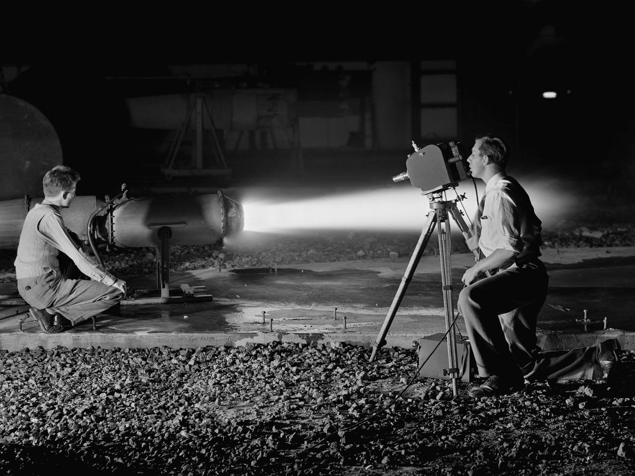
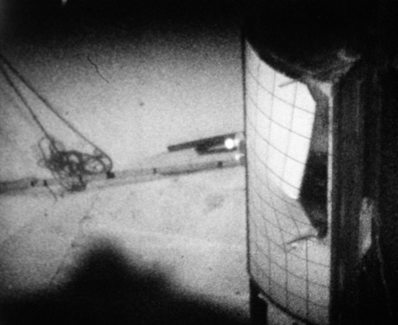
A National Advisory Committee for Aeronautics (NACA) photographer films the test of a ramjet engine at the Lewis Flight Propulsion Laboratory. The laboratory had an arsenal of facilities to test the engines and their components, and immersed itself in the study of turbojet and ramjet engines during the mid-1940s. Combustion, fuel injection, flameouts, and performance at high altitudes were of particular interest to researchers. They devised elaborate schemes to instrument the engines in order to record temperature, pressure, and other data. Many of the tests were also filmed so Lewis researchers could visually review the combustion performance along with the data. The photographer in this image was using high-speed film to document a thrust augmentation study at Lewis’ Jet Static Propulsion Laboratory. The ramjet in this photograph was equipped with a special afterburner as part of a general effort to improve engine performance. Lewis’ Photo Lab was established in 1942. The staff was expanded over the next few years as more test facilities became operational. The Photo Lab’s staff and specialized equipment have been key research tools for decades. They accompany pilots on test flights, use high-speed cameras to capture fleeting processes like combustion, and work with technology, such as the Schlieren camera, to capture supersonic aerodynamics. In addition, the group has documented construction projects, performed publicity work, created images for reports, and photographed data recording equipment.
National Aeronautics and Space Administration (NASA) photographer Arthur Laufman sets up a camera to film a Mercury capsule that was constructed by the Lewis Research Center staff. Lewis engineers and mechanics built two of the capsules for the upcoming Big Joe launches in September 1959. Big Joe was an attempt early in Project Mercury to use a full-scale Atlas booster to simulate the reentry of a mock-up Mercury capsule without actually placing it in orbit. The Photographic Branch, referred to as the Photo Lab, was part of the center’s Technical Reports Division. Originally the group performed normal and high-speed still image and motion picture photography. The photographers documented construction, performed publicity work, created images for reports, photographed data on manometer boards, and recorded test footage. Laufman joined the Photo Lab staff in 1948 and began producing full-length technical films as a tool to educate those outside of the agency on the research being conducted at Lewis. He worked with engineers to determine proper subjects for these films and develop a script. Laufman not only filmed tests, but also supporting footage of facilities, models, and staff members. He then edited the footage and added audio, visuals, and narration. The film masters were assigned standard identification numbers and add to the Photo Lab’s catalogue.
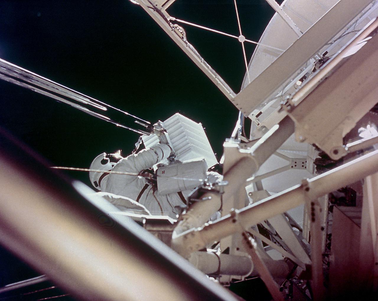
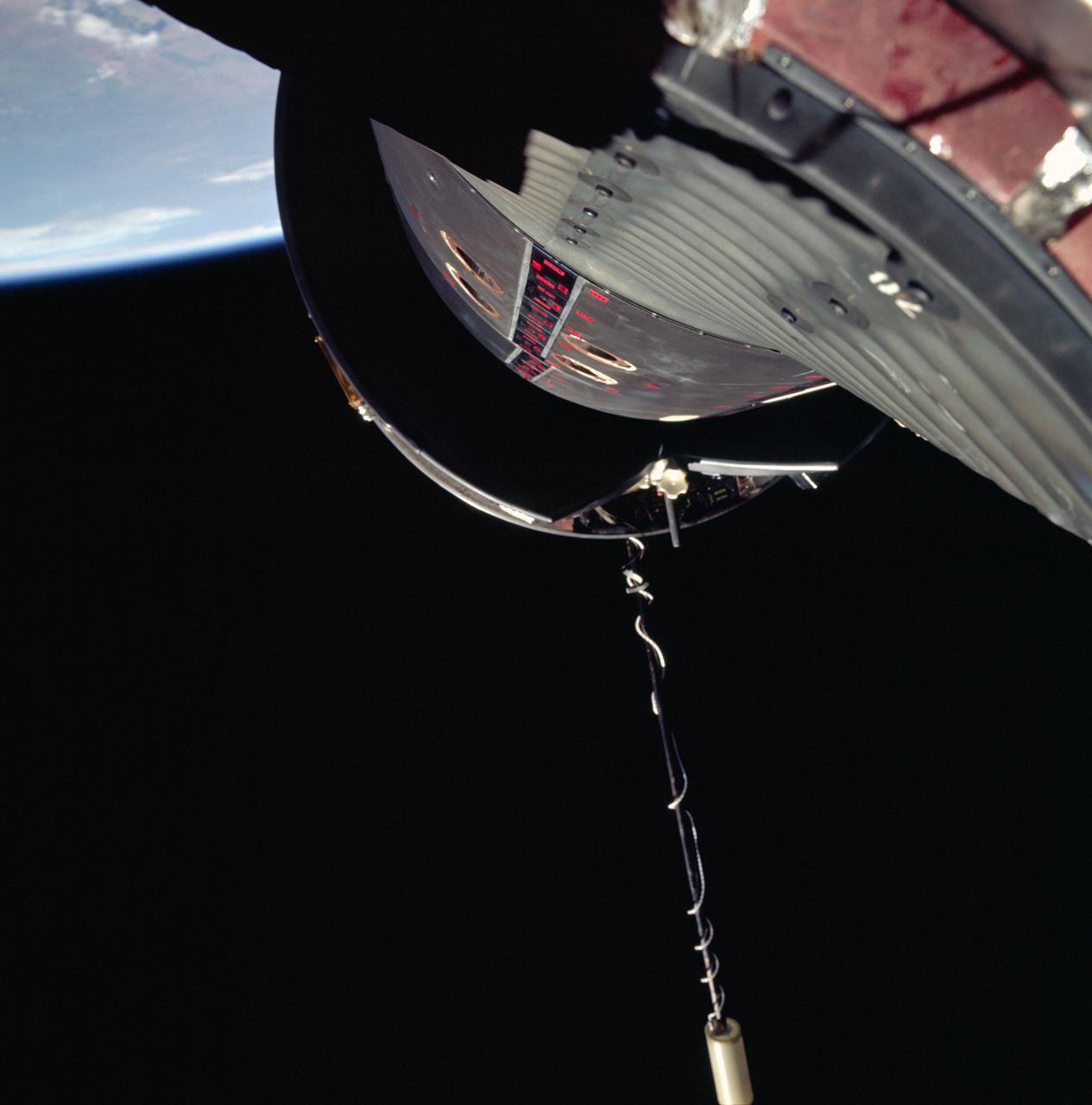
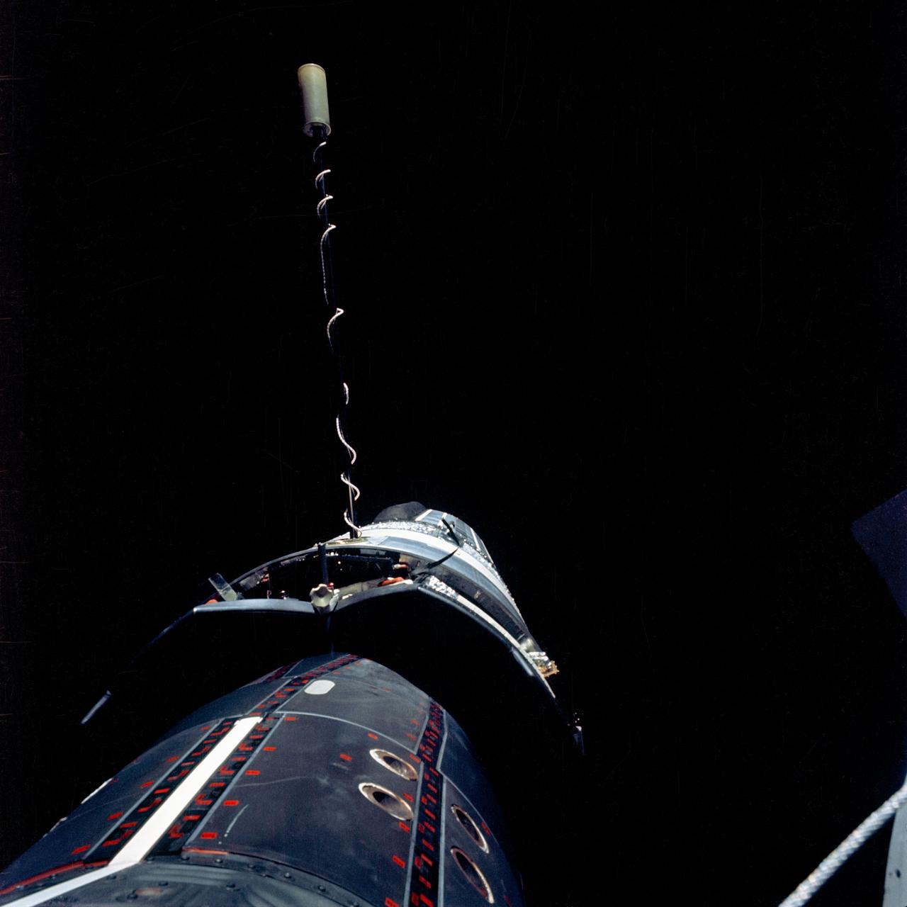
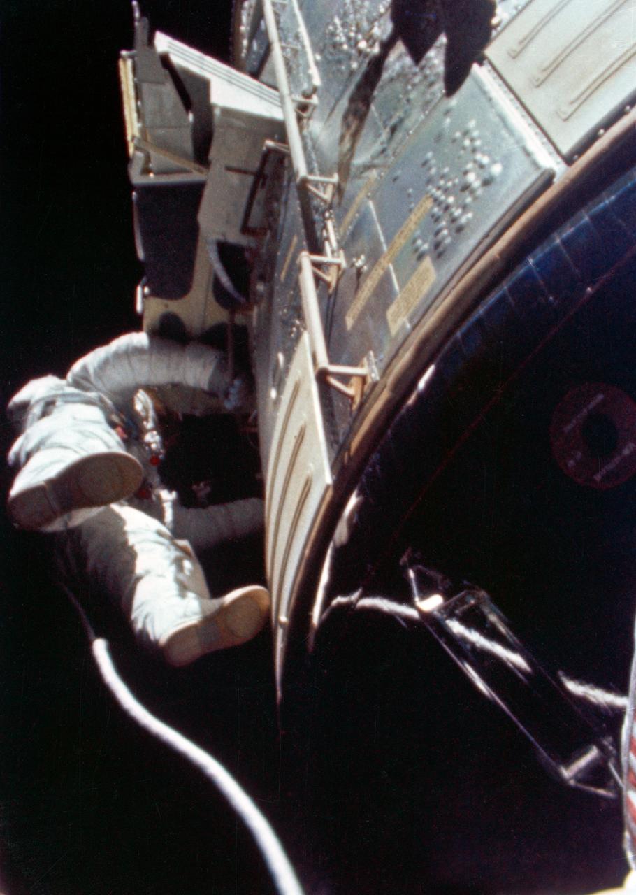
This onboard photograph depicts Astronaut Owen Garriott atop the Apollo Telescope Mount, removing a film magazine (white box) from one of Skylab's solar telescopes during an Extravehicular Activity (EVA) in the second marned Skylab mission (Skylab-3). A long boom transported it back into the waiting hands of another crew member at the airlock door below. During the operation, Garriott, film, boom, and Skylab were 435 kilometers high and speeding around the Earth at 29,000 kilometers per/hour. Because they moved together with no wind resistance, there was little sense of motion.
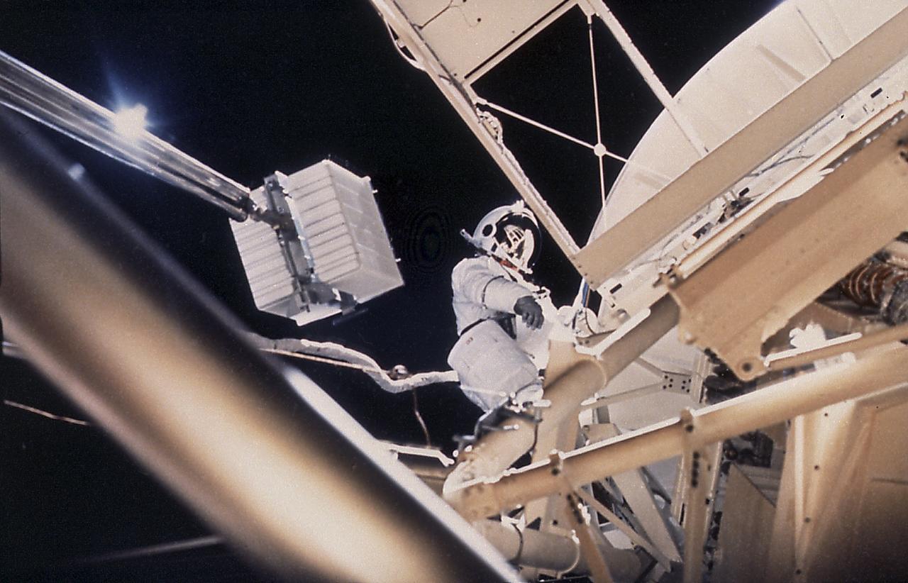
This onboard photograph depicts Astronaut Owen Garriott atop the Apollo Telescope Mount, removing a film magazine (white box) from one of Skylab's solar telescopes during an Extravehicular Activity (EVA) in the second marned Skylab mission (Skylab-3). A long boom transported it back into the waiting hands of another crew member at the airlock door below. During the operation, Garriott, film, boom, and Skylab were 435 kilometers high and speeding around the Earth at 29,000 kilometers per/hour. Because they moved together with no wind resistance, there was little sense of motion.
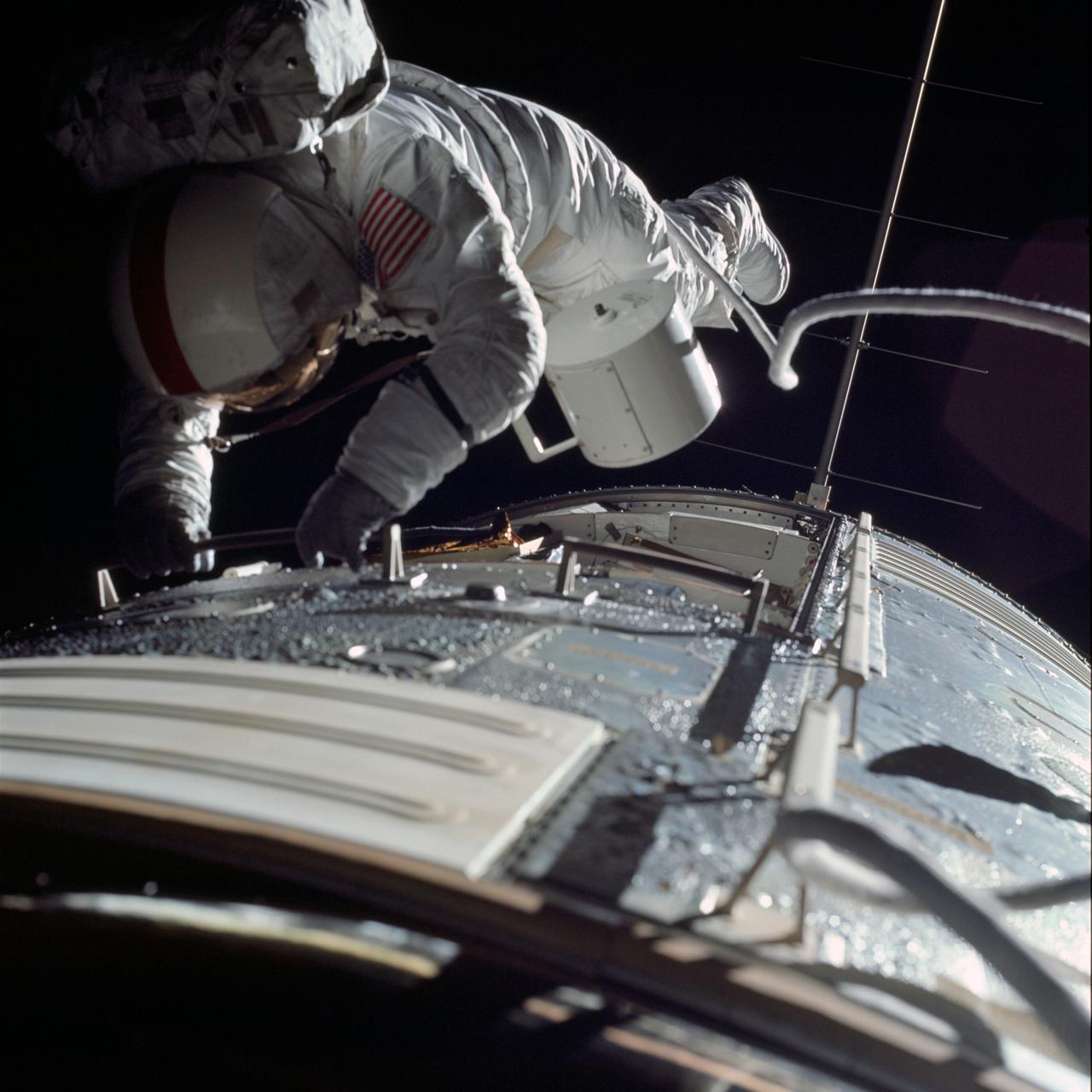
AS17-152-23391 (17 Dec. 1972) --- Astronaut Ronald E. Evans is photographed performing extravehicular activity during the Apollo 17 spacecraft's trans-Earth coast. During his EVA, Evans, command module pilot, retrieved film cassettes from the lunar sounder, mapping camera and panoramic camera. The cylindrical object at Evans' left side is the mapping camera cassette. The total time for the trans-Earth EVA was one hour, seven minutes, 18 seconds, starting at ground elapsed time of 257:25 (2:28 p.m.) and ending at G.E.T. of 258:42 (3:35 p.m.) on Sunday, Dec. 17, 1972.
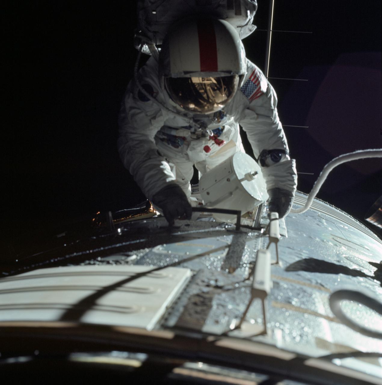
AS17-152-23393 (17 Dec. 1972) --- Astronaut Ronald E. Evans is photographed performing extravehicular activity during the Apollo 17 spacecraft's trans-Earth coast. During his EVA, command module pilot Evans retrieved film cassettes from the Lunar Sounder, Mapping Camera, and Panoramic Camera. The cylindrical object at Evans' left side is the Mapping Camera cassette. The total time for the trans-Earth EVA was one hour seven minutes 18 seconds, starting at ground elapsed time of 257:25 (2:28 p.m.) and ending at ground elapsed timed of 258:42 (3:35 p.m.) on Sunday, Dec. 17, 1972.
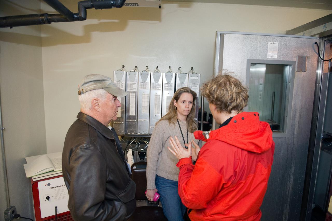
Interview with a NACA, National Advisory Committee for Aeronautics, Flight Photographer, William Wynne.
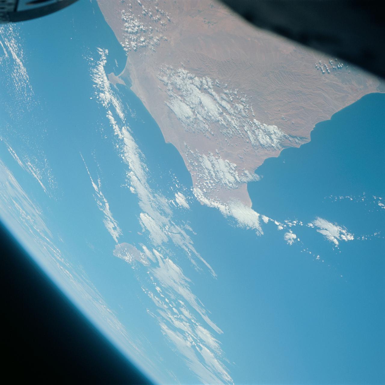
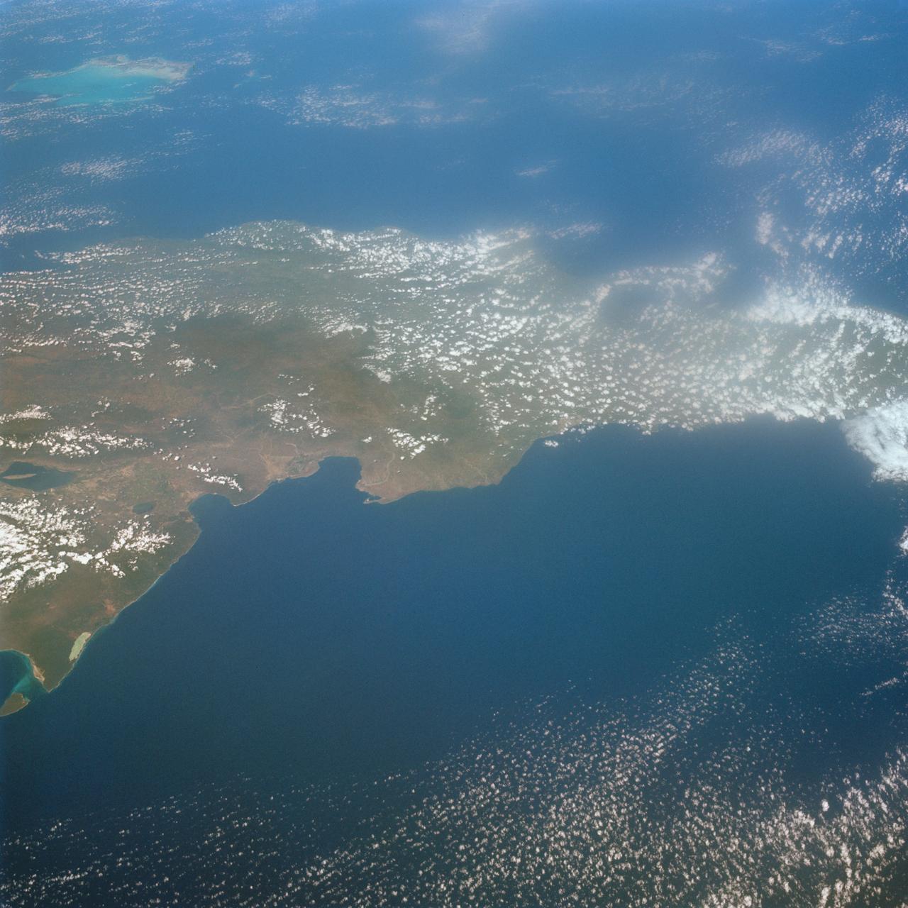
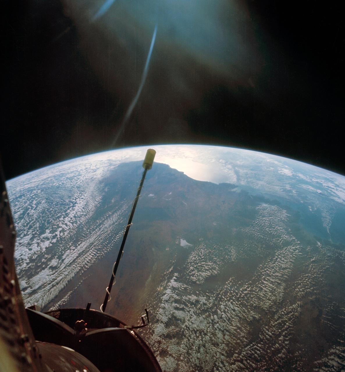
S65-63766 (12 Dec. 1965) --- Ras Azir on the coast of the Republic of Somali, looking east, as seen from the National Aeronautics and Space Administration's Gemini-7 spacecraft during its 117th revolution of Earth. Taken with a modified 70mm Hasselblad camera, using Eastman Kodak, Ektachrome MS (S.O. 217) color film. Photo credit: NASA
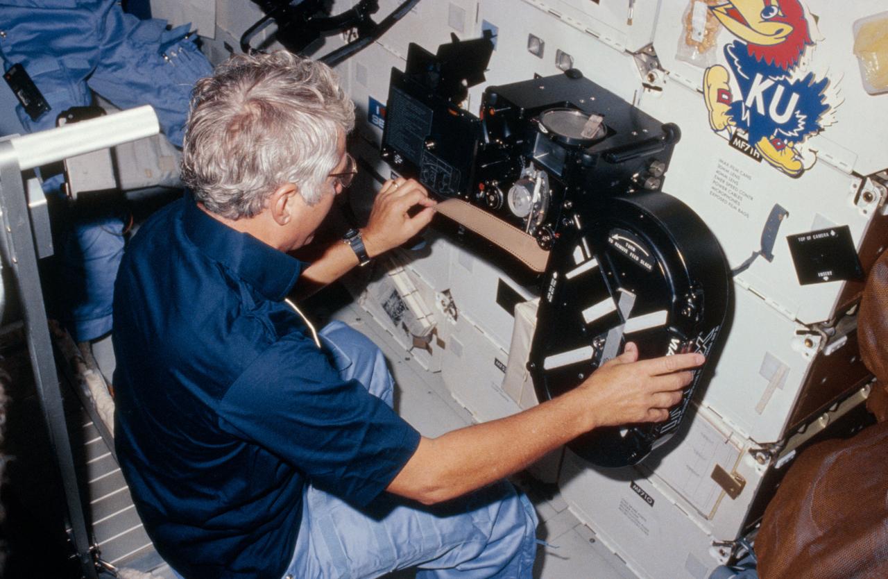
41D-11-004 (8 September 1984 --- View of Crew Commander Henry Hartsfield Jr. loading film into the IMAX camera during the 41-D mission. The camera is floating in front of the middeck lockers. Above it is a sticker of the University of Kansas mascott, the Jayhawk.
This photograph is an enlargement of a frame from a 16mm motion picture film which was mounted within the spacecraft to take film through the hatch window. CAPE KENNEDY, FL CN
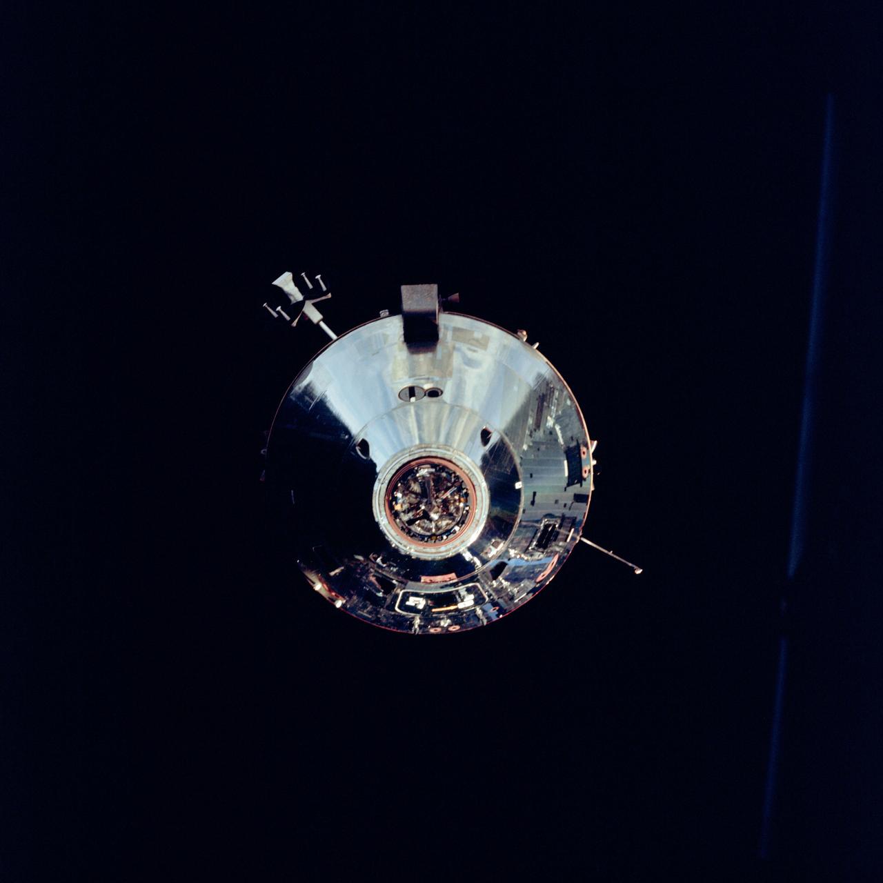
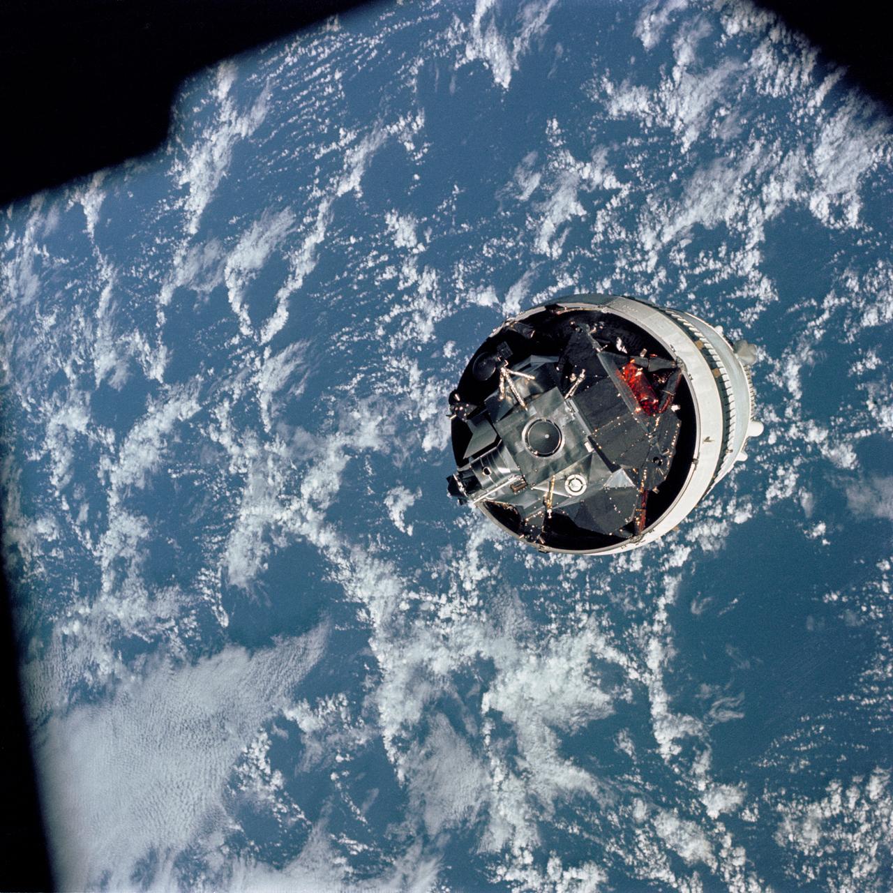
The Apollo 9 Command/Service Modules photographed from the Lunar Module,"Spider",on the fifth day of the Apollo 9 earth-orbital mission. Docking mechanism is visible in nose of the Command Module,"Gumdrop". Object jutting out from the Service Module aft bulkhead is the high-gain S-Band antenna. Film magazine was F, film type was SO-368 Ektachrome with 0.460 - 0.710 micrometers film / filter transmittance response and haze filter,80mm lens.

The Apollo 9 Command/Service Modules photographed through the window from the Lunar Module,"Spider",on the fifth day of the Apollo 9 earth-orbital mission. Docking mechanism is visible in nose of the Command Module,"Gumdrop". Film magazine was F, film type was SO-368 Ektachrome with 0.460 - 0.710 micrometers film / filter transmittance response and haze filter,80mm lens
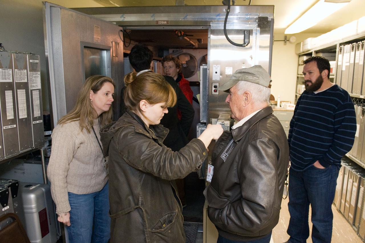
Date: 02-13-12.Location: Bldg 2, LBJ Room.Subject: Bill Anders interview with BBC's James Fox & Visit to Apollo Film Vault..Photographer: James Blair
Date: 02-13-12.Location: Bldg 2, LBJ Room.Subject: Bill Anders interview with BBC's James Fox & Visit to Apollo Film Vault..Photographer: James Blair
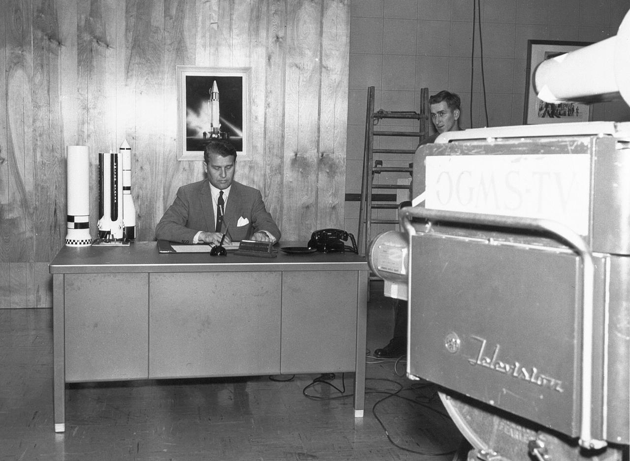
Dr. von Braun was the subject of countless television programs produced both inside and outside of NASA. He is shown here in this undated photograph preparing for one such film session.
The Lunar Module (LM) 3 "Spider",still attached to the Saturn V third (S-IVB) stage,is photographed from the Command/Service Module (CSM) "Gumdrop" on the first day of the Apollo 9 Earth-orbital mission. This picture was taken following CSM/LM-S-IVB separation,and prior to LM extraction from the S-IVB. The Spacecraft Lunar Module Adapter (SLA) panels have already been jettisoned. Film magazine was A,film type was SO-368 Ektachrome with 0.460 - 0.710 micrometers film / filter transmittance response and haze filter, 80mm lens.
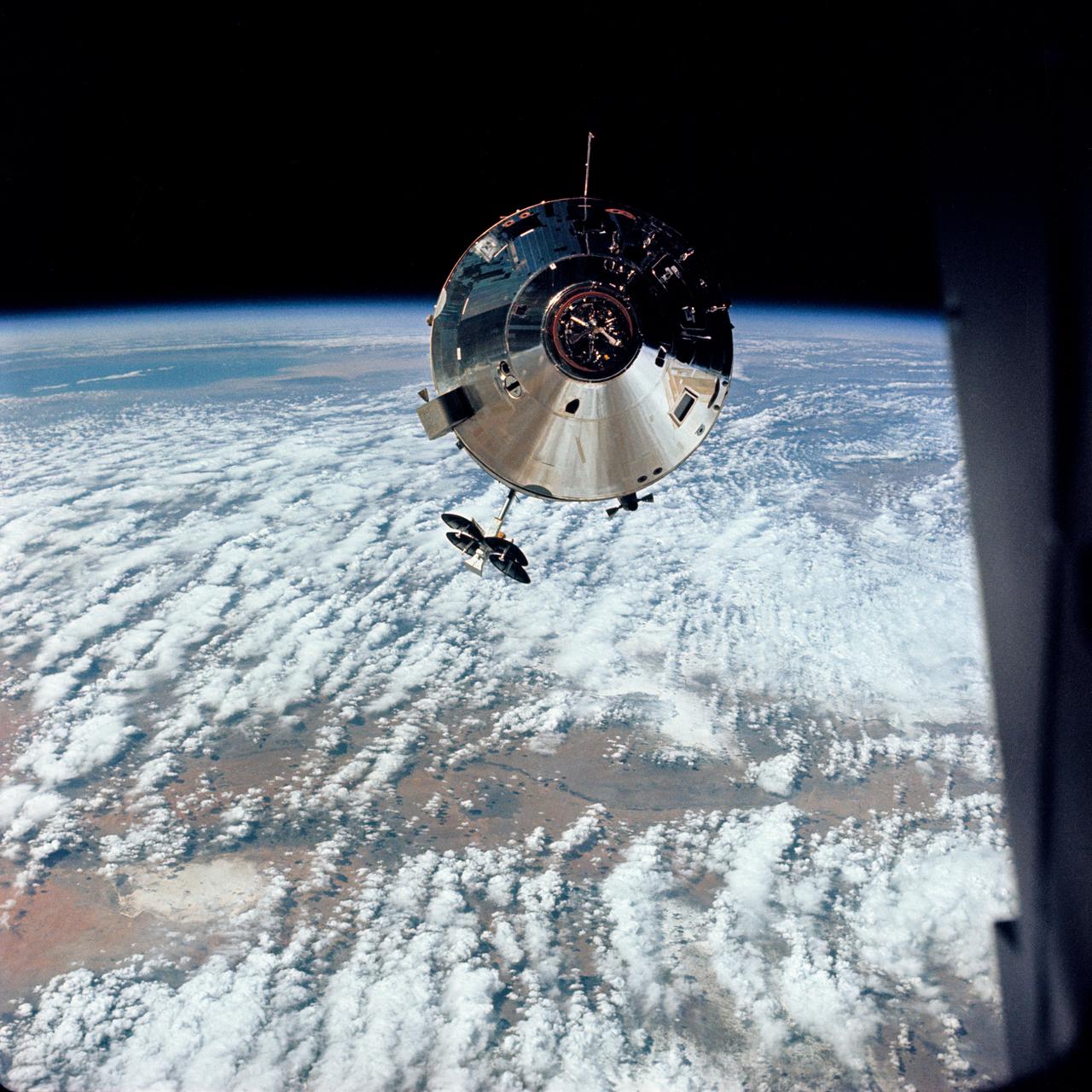
High Oblique photograph (taken over New Mexico) of the Apollo 9 Command/Service Modules taken from the Lunar Module,"Spider",on the fifth day of the Apollo 9 earth-orbital mission. Docking mechanism is visible in nose of the Command Module,"Gumdrop". Object jutting out from the Service Module aft bulkhead is the high-gain S-Band antenna. Film magazine was F, film type was SO-368 Ektachrome with 0.460 - 0.710 micrometers film / filter transmittance response and haze filter,80mm lens. Cloud cover over the Earth is 70%.

AS09-26A-3743A (9 March 1969) --- Color infrared photograph of the Yazoo River Valley, Pearl River, Pearl River Reservoir, and Jackson, Mississippi, area, taken on March 9, 1969, by one of the four synchronized cameras of the Apollo 9 Earth Resources Survey SO65 Experiment. At 1:08 p.m. (EST) when this photograph was made the Apollo 9 spacecraft was at an altitude of 105 nautical miles, and the sun elevation was at 55 degrees above the horizon. The location of the point on Earth's surface at which the four-camera combination was aimed was 32 degrees 34 minutes north latitude, and 89 degrees 57 minutes west longitude. The other three cameras used: (B) black and white film with a red filter; (C) black and white infrared film; and (D) black and white film with a green filter.
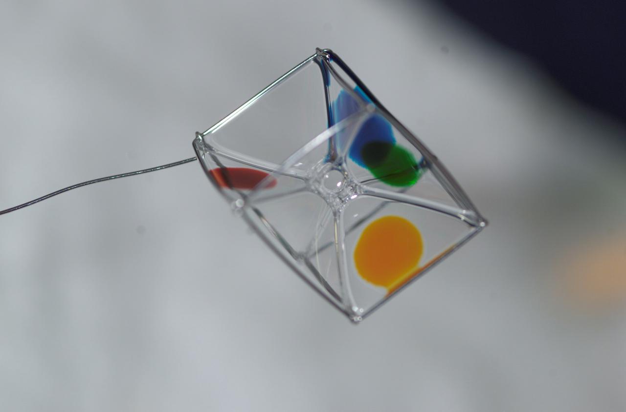
Expedition 6 astronaut Dr. Don Pettit photographed a cube shaped wire frame supporting a thin film made from a water-soap solution during his Saturday Morning Science aboard the International Space Station’s (ISS) Destiny Laboratory. Food coloring was added to several faces to observe the effects of diffusion within the film.
S99-08357 (27 July 1999) --- The fly-over of Space Shuttle Columbia's STS-93 re-entry is seen above the Johnson Space Center's Rocket Park. The Saturn V is below the streak that was left by Columbia re-entering the atmosphere. The image was captured with a Hasselblad 503cx medium format camera with a 30mm Hasselblad lens using an 8-second exposure and an aperture setting of f/8. The film was Kodak PMZ 1000 color negative film. The photographer was Mark Sowa of the NASA Johnson Space Center's photography group.
STS079-341-036 (16-26 Sept. 1996) --- Following the space shuttle Atlantis' separation from the Russian Mir Space Station, astronaut Jerome (Jay) Apt, mission specialist, eyeballs a photographic target on Earth prior to capturing it on film with a handheld 70mm camera from the aft flight deck. Scientists at the Johnson Space Center (JSC), who helped to plan the various target sites, will later analyze the film in their Houston laboratories.
Apollo 8,Moon, Latitude 15 degrees South,Longitude 170 degrees West. Camera Tilt Mode: High Oblique. Direction: Southeast. Sun Angle 17 degrees. Original Film Magazine was labeled E. Camera Data: 70mm Hasselblad; F-Stop: F-5.6; Shutter Speed: 1/250 second. Film Type: Kodak SO-3400 Black and White,ASA 40. Other Photographic Coverage: Lunar Orbiter 1 (LO I) S-3. Flight Date: December 21-27,1968.
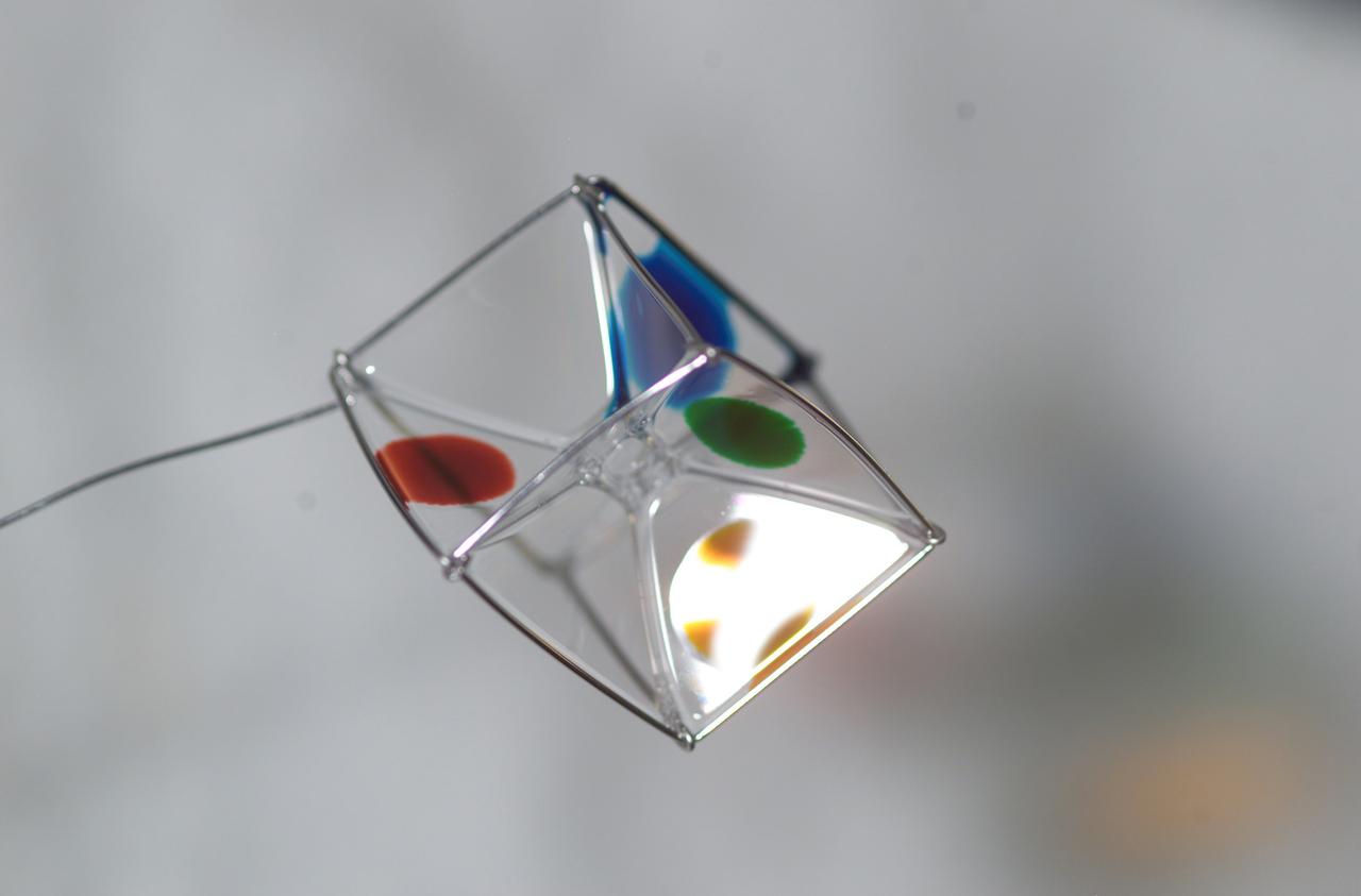
Expedition 6 astronaut Dr. Don Pettit photographed a cube shaped wire frame supporting a thin film made from a water-soap solution during his Saturday Morning Science aboard the International Space Station’s (ISS) Destiny Laboratory. Food coloring was added to several faces to observe the effects of diffusion within the film.
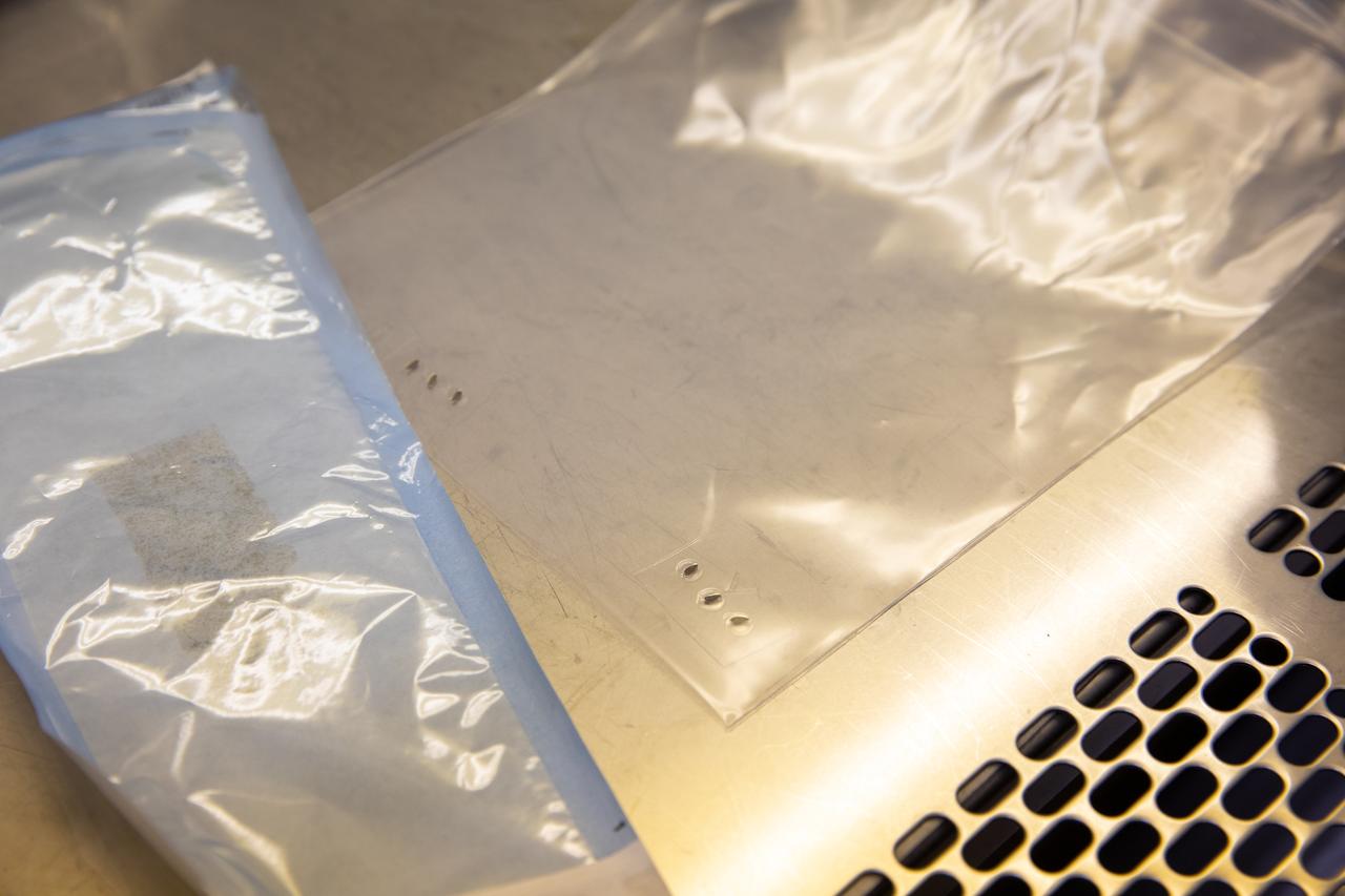
Strips of seed film – a new seed handling material containing red romaine lettuce seeds – are photographed inside the Space Station Processing Facility at NASA’s Kennedy Space Center in Florida on Jan. 16, 2020. The seed film is being prepared for the VEG-03 J experiment that will fly to the International Space Station on Northrop Grumman’s 13th resupply services (NG-13) mission. This seed film experiment involves crew aboard the orbiting laboratory planting the seeds into plant pillows – a common method used to grow plants in space – themselves for the first time ever. The water-soluble, dissolving film addresses the challenge of handling seeds in a microgravity environment and also can be used to deliver fertilizers and other beneficial substances that help plants grow. NG-13 is scheduled to launch from the agency’s Wallops Flight Facility in Virginia on Feb. 9, 2020, at 5:39 p.m. EST.
STS060-84-063 (3-11 Feb 1994) --- This is an excellent photograph of the coastal city of Santo Domingo on the Caribbean Sea. The airports including De las Americas International Airport are clearly seen. This photo illustrates the resolving power of the films. For example, two isolated smoke plumes are clearly seen each side of the city.
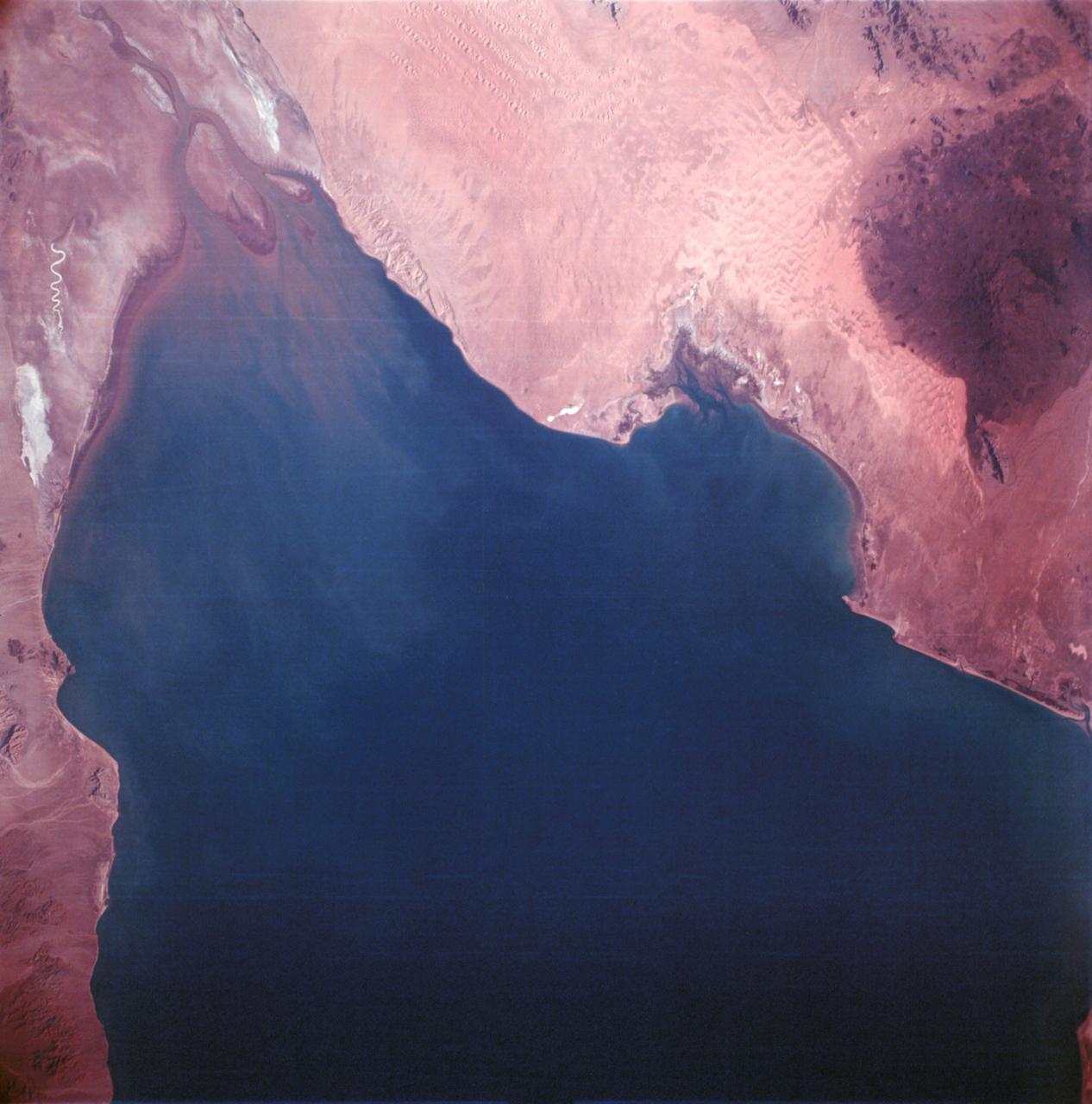
S65-34670 (3-7 June 1965) --- Richat crater in northwest Africa taken from the Gemini-4 spacecraft. Photograph was taken with a modified 70mm Hasselblad camera, using Eastman color film, ASA 64, at a lens setting of 250th of a second at f/11.
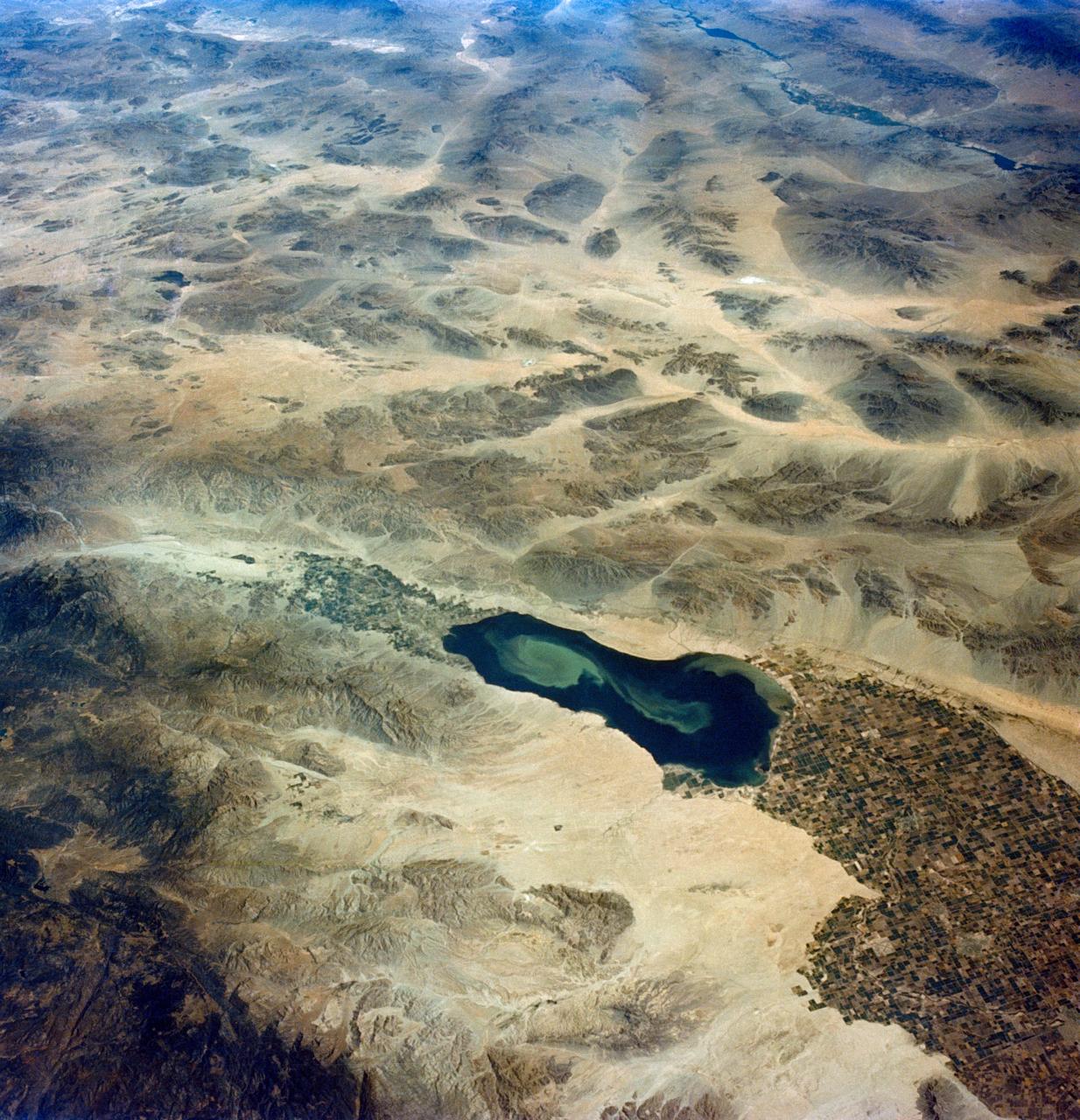
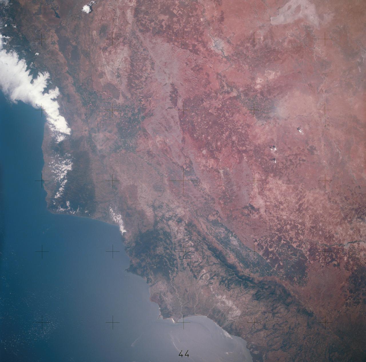
S65-45748 (21-29 Aug. 1965) --- Looking northeast, the Imperial Valley and Salton Sea in southern California is photographed from the Earth-orbiting Gemini-5 spacecraft. This picture was taken with a modified 70mm Hasselblad camera, using MS Ektachrome thin base film, ASA 64.
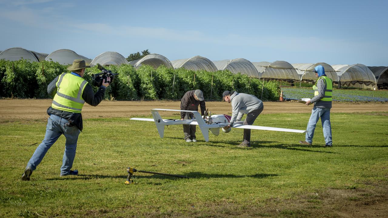
Ames video photographer Jesse Carpenter, left, films Jeff Strebler, Alex Godwin, and Jody Miller, right, as they prepare the L3Harris FVR90 Unmanned Aerial Vehicle (UAV) at the NASA/Overwatch Aero station at the Monterey Bay Academy Airport near Watsonville, California.
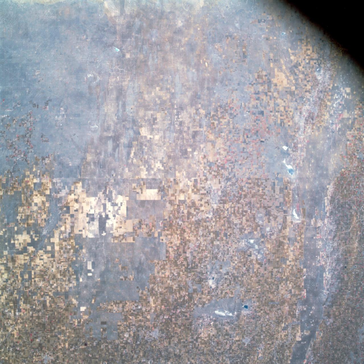
AS09-26A-3801A (12 March 1969) --- Colored infrared photograph of the Phoenix, Arizona area, taken on March 12, 1969, by one of the four synchronized cameras of the Apollo 9 Earth Resources Survey (SO65) Experiment. At 11:28 a.m. (EST) when this picture was made the Apollo 9 spacecraft was at an altitude of 127 nautical miles, and the sun elevation was 32 degrees above the horizon. The location of the point on Earth's surface at which the four-camera combination was aimed was 33 degrees 25 minutes north latitude, and 112 degrees 18 minutes west longitude. The other three cameras used: (B) black and white film with a red filter; (C) black and white infrared film; and (D) black and white film with a green filter.
AS09-26A-3792A (11 March 1969) --- Color infrared photograph of the Atlanta, Georgia area taken on March 11, 1969, by one of the four synchronized cameras of the Apollo 9 Earth Resources Survey (SO-65) experiment. At 11:21 a.m. (EST) when this picture was taken, the Apollo 9 spacecraft was at an altitude of 106 nautical miles, and the sun elevation was 47 degrees above the horizon. The location of the point on Earth's surface at which the four-camera combination was aimed was 33 degrees 10 minutes north latitude, and 84 degrees and 40 minutes west longitude. The other three cameras used: (B) black and white film with a red filter; (C) black and white infrared film; and (D) black and white film with a green filter.
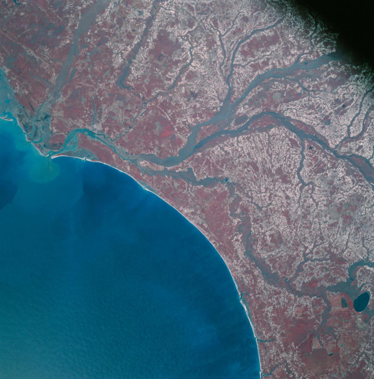
AS09-26A-3793A (12 March 1969) --- Color infrared photograph of the Atlantic Coast of South Carolina, Georgetown-Myrtle Beach-Conway area, taken on March 12, 1969, by one of the four synchronized cameras of the Apollo 9 Earth Resources Survey SO65 Experiment. At 10:00 a.m. (EST) when this picture was made the Apollo 9 spacecraft was at an altitude of 116 nautical miles, and the sun elevation was 39 degrees above the horizon. The location of the point on Earth's surface at which the four-camera combination was aimed was 33 degrees 35 minutes north latitude, and 79 degrees 3 minutes west longitude. The other three cameras used: (B) black and white film with a red filter; (C) black and white infrared film; and (D) black and white film with a green filter.

AS09-26A-3816A (12 March 1969) --- Color infrared photograph of the Atlantic coast of Georgia, Brunswick area, taken on March 12, 1969, by one of the four synchronized cameras of the Apollo 9 Earth Resources Survey SO65 Experiment. At 11:35 a.m. (EST) when this picture was made the Apollo 9 spacecraft was at an altitude of 102 nautical miles, and the sun elevation was 51 degrees above the horizon. The location of the point on Earth's surface at which the four-camera combination was aimed 31 degrees 16 minutes north latitude, and 81 degrees 17 minutes west longitude. The other three cameras used: (B) black and white film with a red filter; (C) black and white infrared film; and (D) black and white film with a green filter.
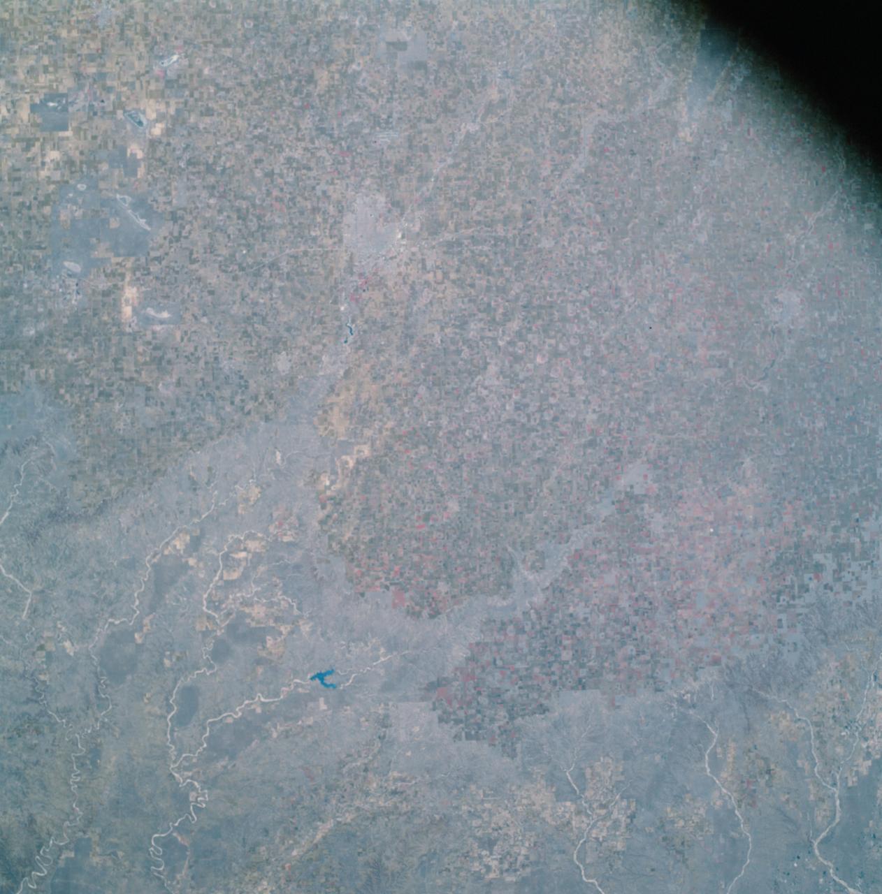
AS09-26A-3808A (12 March 1969) --- Color infrared photograph of the Lubbock, Texas area, taken on March 12, 1969, by one of the four synchronized cameras of the Apollo 9 Earth Resources Survey SO65 Experiment. At 11:31 a.m. (EST) when this picture was made the Apollo 9 spacecraft was at an altitude of 117 nautical miles, and the sun elevation was 38 degrees above the horizon. The location of the point on the surface of Earth at which the four-camera combination was aimed was 33 degrees 41 minutes north latitude, and 101 degrees 29 minutes west longitude. The other three cameras used: (B) black and white film with a red filter; (C) black and white infrared film; and (D) black and white film with a green filter.
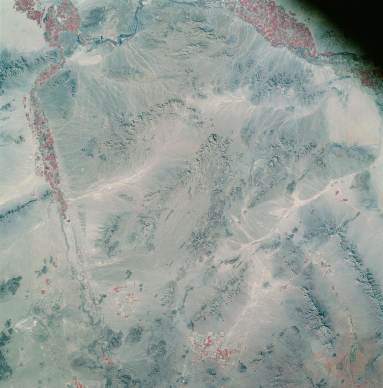
AS09-26A-3800A (12 March 1969) --- Color infrared photograph of southwestern Arizona, Yuma-Gila Desert-Gila River-Colorado River area, taken on March 12, 1969, by one of the four synchronized cameras of the Apollo 9 Earth Resources Survey SO65 Experiment. At 11:28 a.m. (EST) when this picture was made the Apollo 9 spacecraft was at an altitude of 128 nautical miles, and the sun elevation was 30 degrees above the horizon. The location of the point on Earth's surface at which the four-camera combination was aimed 33 degrees 19 minutes north latitude, and 113 degrees 45 minutes west longitude. The other three cameras used: (B) black and white film with a red filter; (C) black and white infrared film; and (D) black and white film with a green filter.
AS09-26A-3807A (12 March 1969) --- Color infrared photograph of the Texas-New Mexico border area, between Lubbock and Roswell, taken on March 12, 1969, by one of the four synchronized cameras of the Apollo 9 Earth Resources Survey (SO65). At 11:30 a.m. (EST) when this picture was made the Apollo 9 spacecraft was at an altitude of 119 nautical miles, and the sun elevation was 38 degrees above the horizon. The location of the point on Earth's surface at which the four-camera combination was aimed was 33 degrees 42 minutes north latitude, and 103 degrees 1 minute west longitude. The other three cameras used: (B) black and white film with a red filter; (C) black and white infrared film; and (D) black and white film with a green filter.

AS09-26A-3748A (9 March 1969) --- A color infrared photograph of the Salton Sea and Imperial Valley area of Southern California and the Mexicali, Mexico area, taken on March 9, 1969, by one of the four synchronized cameras of the Apollo 9 Earth Resources Survey S065 Experiment. At 2:36 p.m. (EST) when this picture was made the Apollo 9 spacecraft was at an altitude of 103 nautical miles, and the sun elevation was 45 degrees above at which the four-camera combination was aimed was 33 degrees 3 minutes north latitude, and 115 degrees 45 minutes west longitude. The other three cameras used: (B) black and white film with a red filter; (C) black and white infrared film; and (D) black and white film with a green filter.
AS09-26A-3802A (12 March 1969) --- Color infrared photograph of the Globe, Arizona area, including Roosevelt Lake and San Carlos Reservoir, taken on March 12, 1969, by one of the four synchronized cameras of the Apollo 9 Earth Resources Survey SO65 Experiment. At 11:29 a.m. (EST) when this picture was made the Apollo 9 spacecraft was at an altitude of 119 nautical miles, and the sun elevation was 38 degrees above the horizon. The location of the point on Earth's surface at which the four-camera combination was aimed was 33 degrees 42 minutes north latitude, and 103 degrees 1 minute west longitude. The other three cameras used: (B) black and white film with a red filter; (C) black and white infrared film; and (D) black and white film with a green filter.

AS09-26A-3728A (8 March 1969) --- Color infrared photograph of the Houston-Galveston-Freeport, Texas Gulf Coast area taken on March 8, 1969, by one of the four synchronized cameras of the Apollo 9 Earth Resources Survey S065 Experiment. At 3:05 p.m. (EST) when this picture was made the Apollo 9 spacecraft was at an altitude of 105 nautical miles, and the sun elevation was 54 degrees above the horizon. The location of the point on Earth's surface at which the four-camera combination was aimed was 29 degrees 4 minutes north latitude, and 95 degrees 24 minutes west longitude. The three other cameras used: (B) black and white film with a red filter; (C) black and white infrared film; and (D) black and white film with a green filter.
Apollo 8,Moon,Target of Opportunity (T/O) 10, Various targets. Latitude 18 degrees South,Longitude 163.50 degrees West. Camera Tilt Mode: High Oblique. Direction: South. Sun Angle 12 degrees. Original Film Magazine was labeled E. Camera Data: 70mm Hasselblad; F-Stop: F-5.6; Shutter Speed: 1/250 second. Film Type: Kodak SO-3400 Black and White,ASA 40. Other Photographic Coverage: Lunar Orbiter 1 (LO I) S-3. Flight Date: December 21-27,1968.

Looking for a faster computer? How about an optical computer that processes data streams simultaneously and works with the speed of light? In space, NASA researchers have formed optical thin-film. By turning these thin-films into very fast optical computer components, scientists could improve computer tasks, such as pattern recognition. Dr. Hossin Abdeldayem, physicist at NASA/Marshall Space Flight Center (MSFC) in Huntsville, Al, is working with lasers as part of an optical system for pattern recognition. These systems can be used for automated fingerprinting, photographic scarning and the development of sophisticated artificial intelligence systems that can learn and evolve. Photo credit: NASA/Marshall Space Flight Center (MSFC)
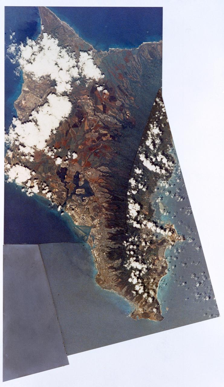
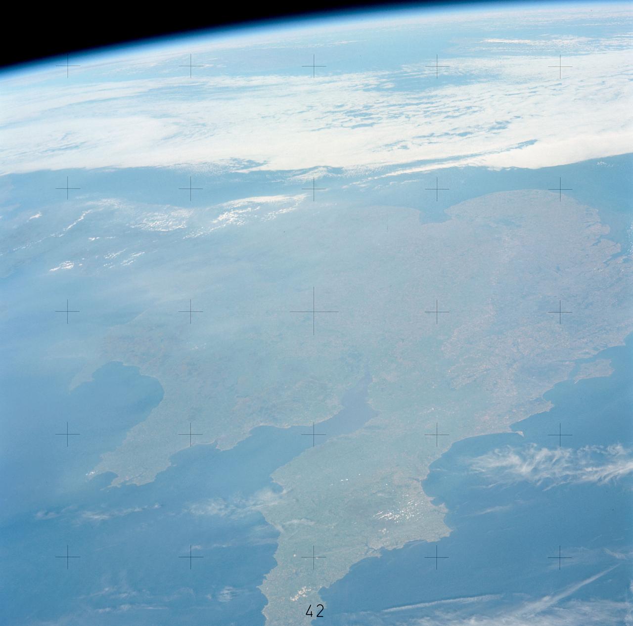
AST-17-1378 (20 July 1975) --- A near vertical view of the most southerly portion of the Island of Sicily in the Mediterranean Sea, as photographed from the Apollo spacecraft in Earth orbit during the joint U.S.-USSR Apollo-Soyuz Test Project mission. This view includes the towns of Gala, Pachino, Avela and Pozzalo. The photograph was taken at an altitude of 228 kilometers (141 statute miles) with a 70mm Hasselblad camera using high-definition aerial Ektachrome SO-242 type film.

AS17-145-22224 (12 Dec. 1972) --- Astronaut Eugene A. Cernan, Apollo 17 commander, is photographed inside the lunar module on the lunar surface following the second extravehicular activity (EVA) of his mission. Note lunar dust on his suit. The photograph was taken by astronaut Harrison H. Schmitt, lunar module pilot, using a 70mm handheld Hasselblad camera and S0-368 film.
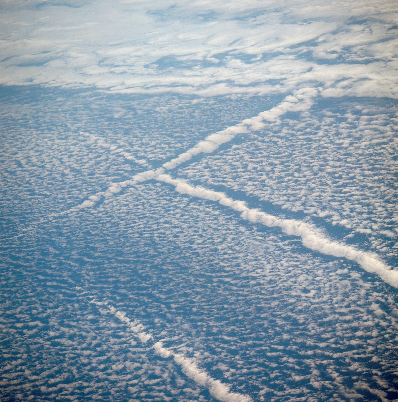
AST-01-042 (16 July 1975) --- An oblique view of unique cloud patterns over the Pacific Ocean caused by aircraft contrail shadows altering cumulus clouds and forming straight line clouds, as photographed from the Apollo spacecraft in Earth orbit during the joint U.S.-USSR Apollo-Soyuz Test Project mission. This area is southwest of Los Angeles, California. This photograph was taken at an altitude of 177 kilometers (110 statute miles) with a 70mm Hasselblad camera using medium-speed Ektachrome QX-807 type film.
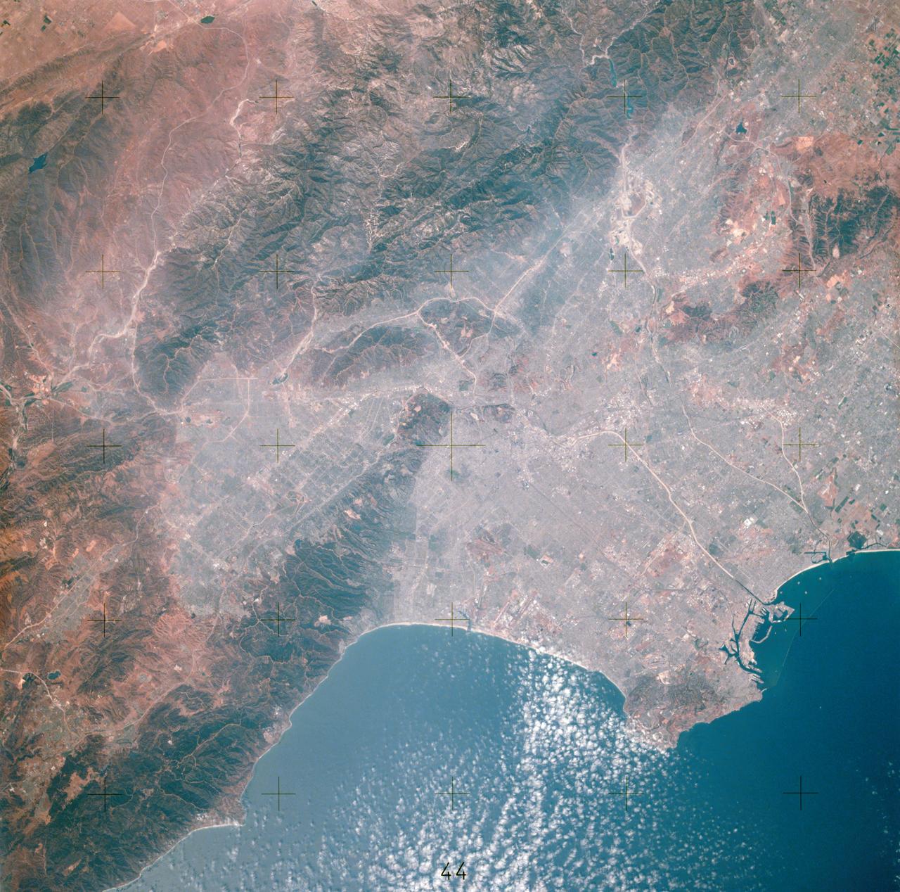
AST-14-881 (16 July 1975) --- An excellent view of Los Angeles, California, as photographed from the Apollo spacecraft in Earth orbit during the joint U.S.-USSR Apollo-Soyuz Test Project (ASTP) mission. Downtown Los Angeles is near the center of the picture. The photograph was taken at an altitude of 193 kilometers (120 statute miles), with a 70mm Hasselblad camera using SO-242 high-definition Ektachrome film.
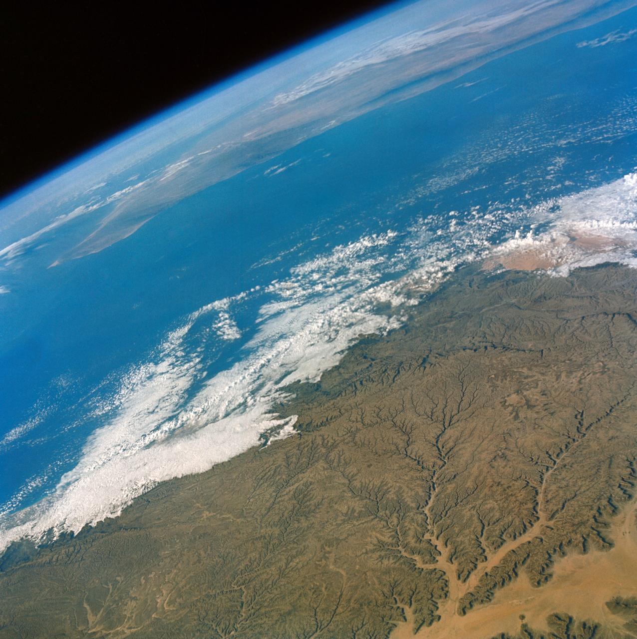
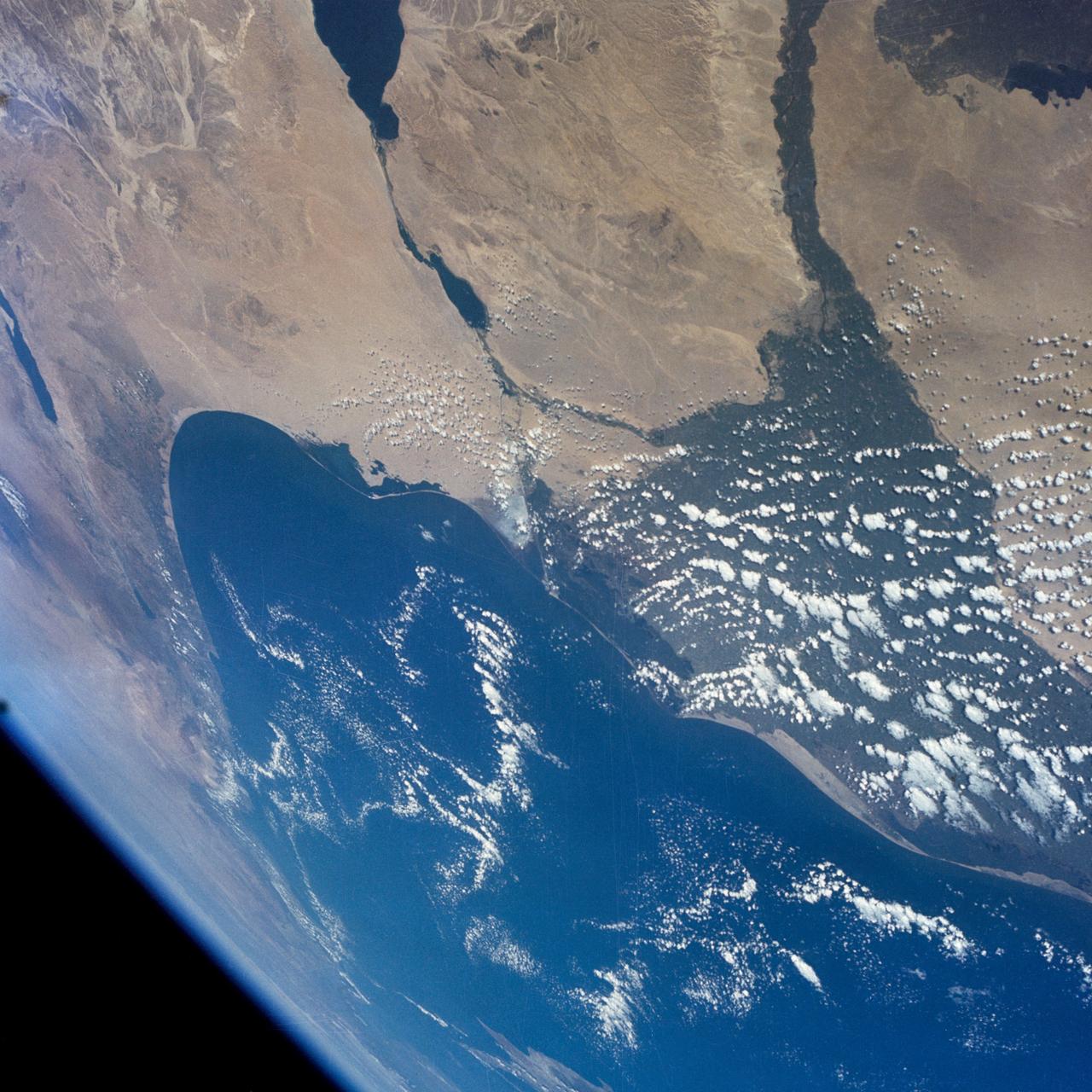
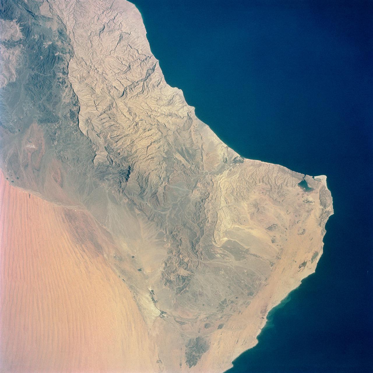
S65-34659 (3-7 June 1965) --- Among the many photographs taken from the Gemini-4 spacecraft during its orbital flight around Earth was this view of the Hahramaut Plateau on the southern portion of the Arabian Peninsula. The Wadi Hahramaut is in the foreground; with the Gulf of Aden (dark blue). This photograph was made with a modified 70mm Hasselblad camera, using Eastman color film, ASA 64, at a lens setting of 250th of a second at f/11.
AST-13-797 (24 July 1975) --- An infrared, near vertical view of the Chesapeake Bay area showing portions of Virginia, Maryland and Delaware, as photographed from the Apollo spacecraft in Earth orbit during the joint U.S.-USSR Apollo-Soyuz Test Project mission. Richmond and Norfolk can be seen in this picture. Tidewater Virginia covers much of this view. The photograph was taken at an altitude of 217 kilometers (135 statute miles) with a 70mm Hasselblad camera using infrared Aerochrome type 2443 Ektachrome film.
S65-63194 (15 Dec. 1965) --- This photograph of the National Aeronautics and Space Administration's (NASA) Gemini-7 spacecraft was taken through the hatch window of the Gemini-6 spacecraft during rendezvous and station keeping maneuvers at an altitude of approximately 160 miles on Dec. 15, 1965. The photograph was taken with a Hasselblad camera using Kodak SO 217 film with an ASA of 1964. Photo credit: NASA or National Aeronautics and Space Administration
SL3-114-1625 (July-September 1973) --- An excellent view of the expended S-IVB second stage of the Skylab 3/Saturn 1B space vehicle is seen in this photograph taken from the Skylab 3 Command and Service Module (CSM) in Earth orbit. The land mass below is Italy and France, with part of the Mediterranean Sea visible. This photograph was taken with a handheld 70mm Hasselblad camera using a 100mm lens, and medium speed Ektachrome film. Photo credit: NASA
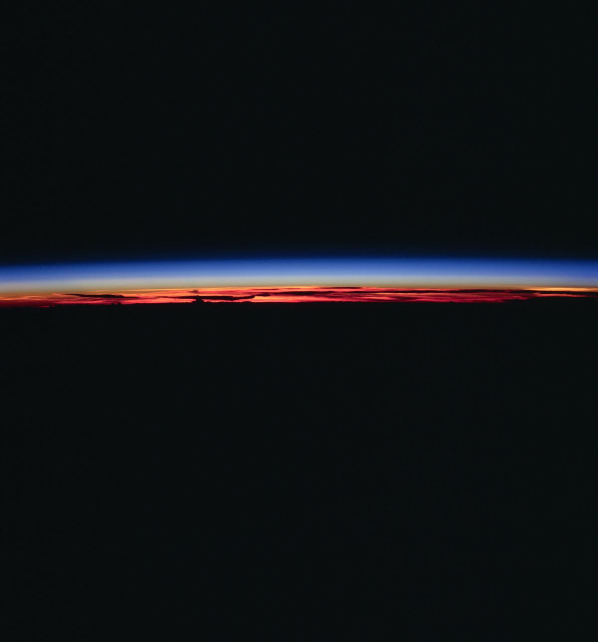
AST-27-2339 (20 July 1975) --- The Earth’s limb at sunrise and cloud silhouettes in the Southern Hemisphere, as photographed from the Apollo spacecraft during the joint U.S.-USSR Apollo-Soyuz Test Project mission. The photograph was taken at an altitude of 230 kilometers (143 statute miles) with a 70mm Hasselblad camera using medium-speed Ektachrome QX-807 type film.
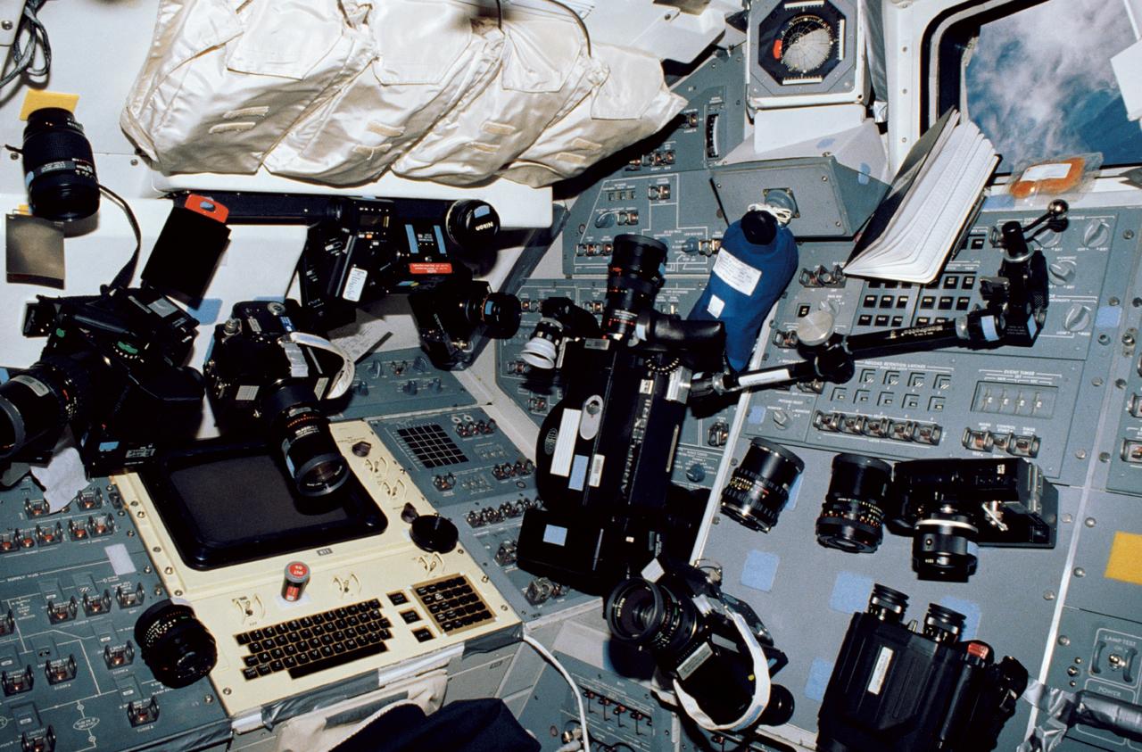
STS035-10-015 (2-10 Dec 1990) --- This busy scene shows cameras and supportive photographic gear temporarily stowed on Space Shuttle Columbia's aft flight deck. It was photographed with a 35mm camera by astronaut Jeffrey A. Hoffman, mission specialist, who called the cluster a "camera forest." The seven STS-35 crewmembers trained to record a wide variety of imagery with an equally broad range of equipment. In addition to cameras, a spot meter, film, a pair of binoculars, a bracket, lenses, lens cleaner and other photographic equipment are in the scene. Clouds over ocean waters are framed by an aft flight deck window at upper right.
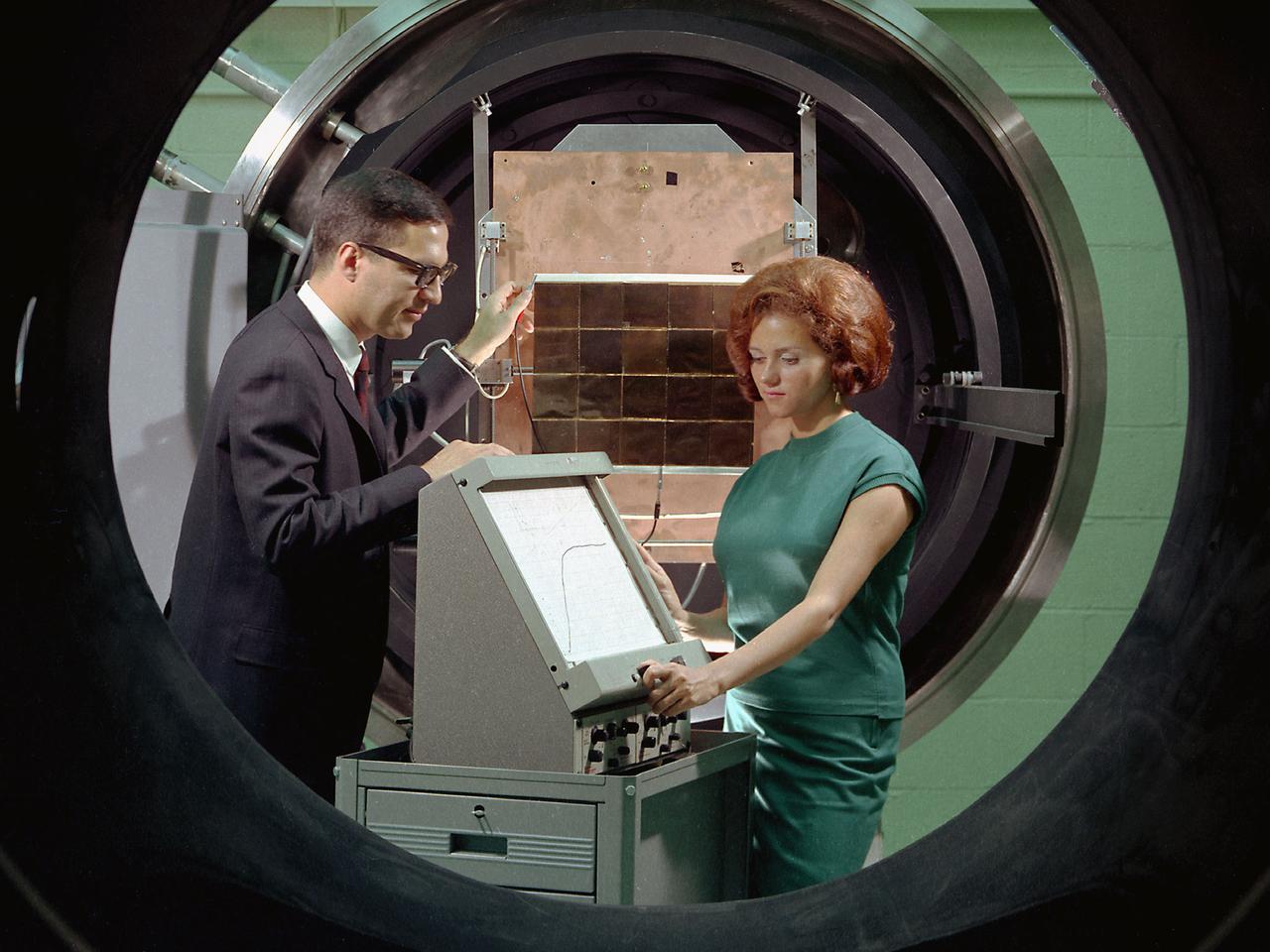
George Mazaris, works with an assistant to obtain the preliminary measurements of cadmium sulfide thin-film solar cells being tested in the Space Environmental Chamber at the National Aeronautics and Space Administration (NASA) Lewis Research Center. Lewis’ Photovoltaic Fundamentals Section was investigating thin-film alternatives to the standard rigid and fragile solar cells. The cadmium sulfide semiconductors were placed in a light, metallized substrate that could be rolled or furled during launch. The main advantage of the thin-film solar cells was their reduced weight. Lewis researchers, however, were still working on improving the performance of the semiconductor. The new thin-film solar cells were tested in a space simulation chamber in the CW-6 test cell in the Engine Research Building. The chamber created a simulated altitude of 200 miles. Sunlight was simulated by a 5000-watt xenon light. Some two dozen cells were exposed to 15 minutes of light followed by 15 minutes of darkness to test their durability in the constantly changing illumination of Earth orbit. This photograph was taken for use in a NASA recruiting publication.
S65-63849 (8 Dec. 1965) --- The eastern Mediterranean area as seen from the National Aeronautics and Space Administration's Gemini-7 spacecraft. The Nile Delta in Egypt is at bottom. The Suez Canal, Gulf of Suez and Red Sea are in the center of the photograph. The Sinai Peninsula is in the upper right corner of the picture. The body of water at the top edge of the photograph is the Gulf of Aqaba. The Dead Sea can be seen at top center. Israel, Palestine, Jordan and Syria are also at top center. The Island of Cyprus is at extreme left. Astronauts Frank Borman and James A. Lovell Jr. took this picture using a modified 70mm Hasselblad camera, with Eastman Kodak, Ektachrome MS (S.O. 217) color film. Photo credit: NASA
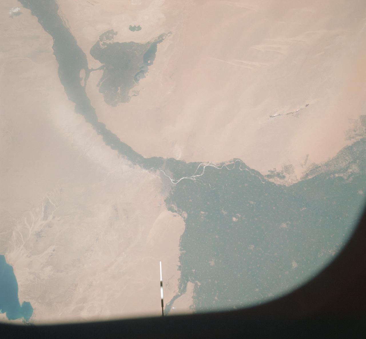
AST-09-555 (19 July 1975) --- A vertical view of a portion of the Arab Republic of Egypt, as photographed from the Apollo spacecraft in Earth orbit during the joint U.S.-USSR Apollo-Soyuz Test Project mission. The Nile Delta is in the most northerly corner of the picture. The City of Cairo on the Nile River is in the center of the photograph. The Gulf of Suez is in the most easterly corner of the picture. El Faiyum is south-southwest of Cairo. This picture was taken at an altitude of 223 kilometers (138 statute miles), with a 70mm Hasselblad camera using medium-speed Ektachrome QX-807 type film.
AST-16-1268 (20 July 1975) --- A near vertical view of a portion of the Mediterranean coast of Turkey and Syria, as photographed from the Apollo spacecraft in Earth orbit during the joint U.S-USSR Apollo-Soyuz Test Project mission. This view covers the Levant Coast north of Beirut, showing the cities of Aleppo, Hamah, Homs and Latakia. The Levantine rift bends to the northeast. This picture was taken with a 70mm Hasselblad camera using high-definition aerial Ektachrome SO-242 type film. The altitude of the spacecraft was 225 kilometers (140 statute miles) when this photograph was taken.
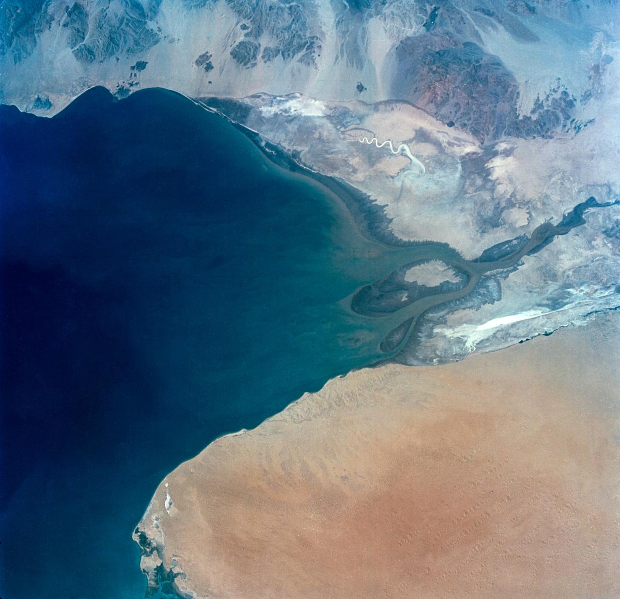
S65-34673 (3-7 June 1965) --- This photograph shows the north end of the Gulf of California at the mouth of the Colorado River as it was seen from the Gemini-4 spacecraft during orbital flight June 3-7, 1965. This picture was part of the Synoptic Terrain Photography experiments conducted during the flight to obtain high quality photographs of large land areas already mapped by aerial photography. In charge of these experiments was Dr. Paul D. Lowman Jr., NASA geologist from Goddard Space Flight Center, Greenbelt, Md. This picture was taken with a modified 70mm Hasselblad camera using Eastman color film, ASA 64 at a lens setting of 250th of a second at f/11.
This 1970 photograph shows the Skylab's Ultraviolet (UV) Spectrograph, an Apollo Telescope Mount instrument. Its telescope, with camera and TV capability, photographed the Sun in selected ultraviolet wavelengths. The spectrograph was used to record the spectrum of UV emissions, such as flares or filaments, from a small individual feature on the solar disc. Real-time TV was used by the crew to monitor the performance of the telescope, transmit to the ground, and record. The exposed films were retrieved by astronaut extravehicular activities. The Marshall Space Flight Center had program management responsibility for the development of the Skylab hardware and experiments.
STS049-71-042 (8 May 1992) --- This photograph, taken from the Earth-orbiting Space Shuttle Endeavour, shows a collapsed thunderstorm in the southwestern Pacific Ocean. The clouds were pushed from this circular area of the ocean's surface by relatively cool air that spread downward and outward from a dying thunderstorm. Around the edges of the downdrafted air, new, though smaller, storms are developing. The photo was taken on May 8, 1992, between Borneo and the Philippine island of Mindoro. Two coral atolls can be seen near the center of the photograph. The crew members used a handheld Hasselblad camera, 250-mm lens, color film to expose the image.
SL2-05-102 (June 1973) --- A black and white photograph of the San Francisco Bay California area, taken from the Skylab 1-2 space station cluster in Earth orbit. THE PICTURE SHOULD BE HELD WITH THE CLOUDS AND PACIFIC OCEAN ON THE LEFT. This photograph was taken by one of six lenses of the Itek-furnished S190-A Multispectral Photographic Facility Experiment in the Multiple Docking Adapter of the space station. Note the thickly populated and highly developed area around the Bay. Among the cities visible in this photograph are San Francisco, Oakland, Berkeley and San Jose. This view extends eastward to show a portion of the San Joaquin Valley. The S190-A experiment is part of the Skylab Earth Resources Experiments Package (EREP). Type SO-022 film was used. This station covered the spectral region from 0.6 to .07 micrometers. Photo credit: NASA

SL3-22-0214 (July-September 1973) --- A vertical view of southeastern Washington State as photographed from Earth orbit by one of the six lenses of the Itek-furnished S190-A Multispectral Photographic Facility Experiment aboard the Skylab space station. The Snake River flows into the Columbia River in the most southerly corner of the picture. The Wallula Lake is below the junction of the two rivers. The Yakima Valley is at the southwestern edge of the photograph. The Columbia Basin is in the center of the picture. The Cascade Range extends across the northwest corner of the photograph. This picture was taken with type SO-356 regular color film. The S190-A experiment is part of the Earth Resources Experiments Package. Federal agencies participating with NASA on the EREP project are the Departments of Agriculture, Commerce, Interior, the Environmental Protection Agency and the Corps of Engineers. All EREP photography is available to the public through the Department of Interior?s Earth Resources Observations Systems Data Center, Sioux Falls, South Dakota, 57198. Photo credit: NASA
SL2-03-118 (June 1973) --- An infrared photograph of the San Francisco Bay, California area, taken from the Skylab 1/2 space station in Earth orbit. THE PICTURE SHOULD BE HELD WITH THE CLOUDS AND PACIFIC OCEAN ON THE LEFT. This photograph was taken by one of the six lenses of the Itek-furnished S190-A Multispectral Photographic Facility Experiment in the Multiple Docking Adapter of the space station. Type 2443 film was used. Note the thickly populated and highly developed area around the bay. Among the cities visible in this photograph are San Francisco, Oakland, Berkeley and San Jose. This view extends eastward to show a portion of the San Joaquin Valley. The S190-A experiment is part of the Skylab Earth Resources Experiment Package (EREP). Photo credit: NASA
SL2-06-102 (June 1973) --- A black and white photograph of the San Francisco Bay California area, taken from the Skylab 1-2 space station cluster in Earth orbit. THE PICTURE SHOULD BE HELD WITH THE CLOUDS AND PACIFIC OCEAN ON THE LEFT. This photograph was taken by one of six lenses of the Itek-furnished S190-A Multispectral Photographic Facility Experiment in the Multiple Docking Adapter of the space station. Note the thickly populated and highly developed area around the Bay. Among the cities visible in this photograph are San Francisco, Oakland, Berkeley and San Jose. This view extends eastward to show a portion of the San Joaquin Valley. The S190-A experiment is part of the Skylab Earth Resources Experiments Package (EREP). Type SO-022 film was used. This station covered the spectral region from 0.5 to 0.6 micrometers. Photo credit: NASA
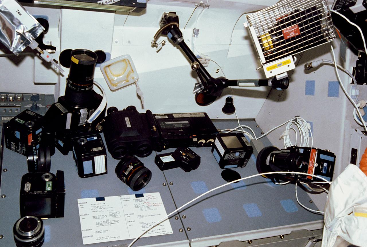
This array of photographic equipment, displayed on the aft flight deck payload station, represents just a part of the imaging and recording hardware which was carried aboard Discovery, Orbiter Vehicle (OV) 103, for STS-31's five day mission. Lenses, film magazines, cassettes, recorders, camera chassis, a pair of binoculars, spot meter, tape recorder, and a bracket-mounted light fixture are included among the array.
S73-34857 (July-September 1973) --- A composite of two photographs of the Island of Oahu, County of Honolulu, State of Hawaii, taken by one of the Skylab 3 crewmen from the Skylab space station in Earth orbit. The two pictures (SL3-128-3009 and SL3-128-3010) were taken with a hand-held 35mm Nikon camera, a 55/300mm lens and so-368 medium-speed Ektacrome film. Pearl Harbor is clearly visible. The city of Honolulu is located next to the triangle-shaped seaplane runway. Photo credit: NASA
S65-34661 (3-7 June 1965) --- Among the photographs of Earth's terrain taken from the Gemini-4 spacecraft during its orbital mission was this view of the southeastern tip of the Arabian Peninsula with the Gulf of Oman at upper right. Seif dunes (sand) at lower left. This picture was taken with a modified 70mm Hasselblad camera, using Eastman color film, ASA 64 at a setting of 250th of a second at f/11. Dr. Paul Lowman Jr., NASA geologist, was in charge of the Synoptic Terrain Photography.
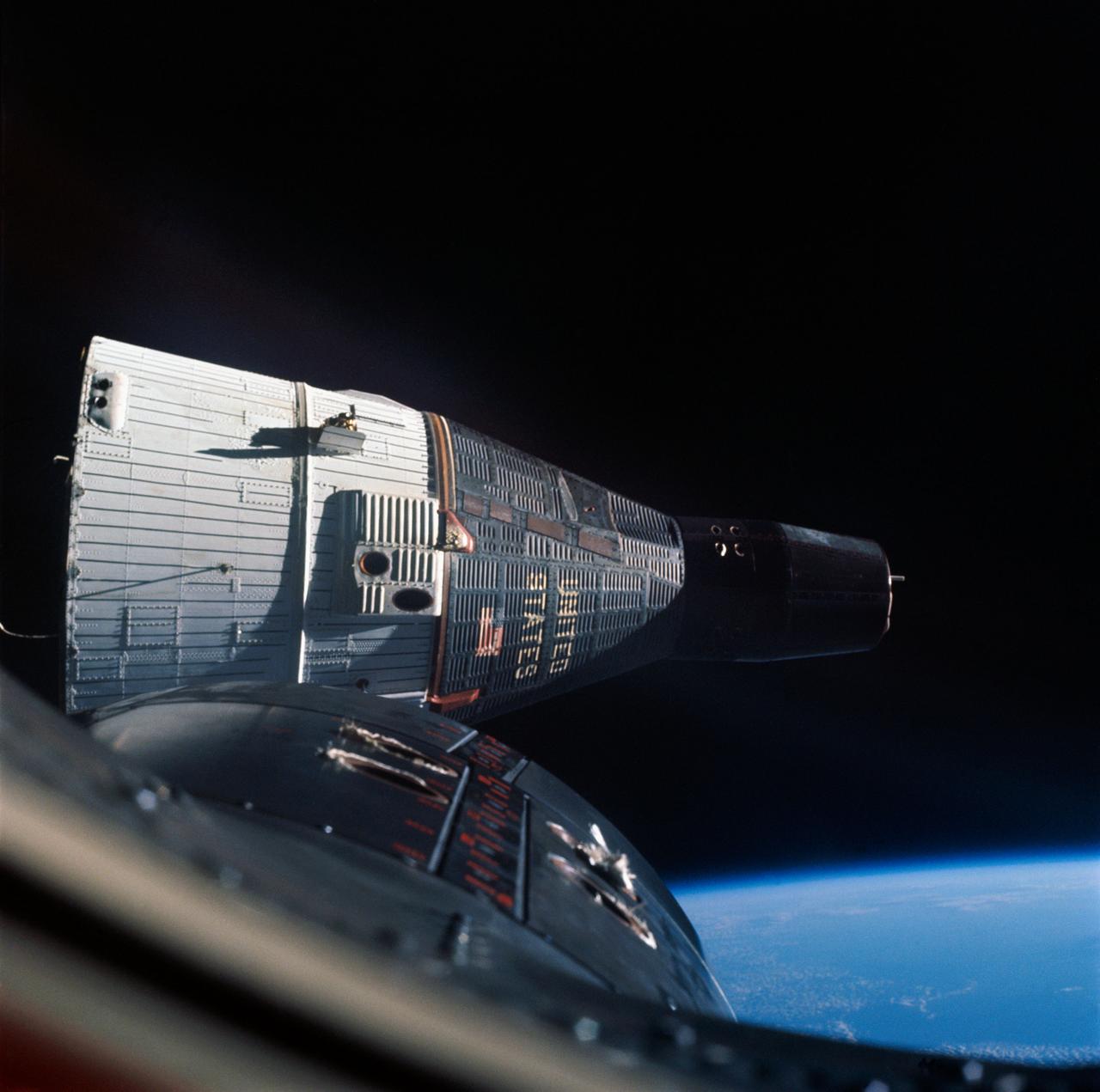
S66-54656 (13 Sept. 1966) --- Nose of Gemini-11 spacecraft and Agena Target Vehicle while docked as photographed by astronaut Richard F. Gordon Jr., pilot, during his stand-up extravehicular activity (EVA). Taken with a modified 70mm Hasselblad camera, using Eastman Kodak, Ektachrome, MS (S.O. 368) color film. Photo credit: NASA
ISS01-324-002 (18 November 2000) --- A Progress supply ship linked up to the orbiting International Space Station (ISS) at 3:48 GMT, November 18, bringing Expedition 1 commander William M. Shepherd, pilot Yuri P. Gidzenko and flight engineer Sergei K. Krikalev two tons of food, clothing, hardware and holiday gifts from their families. The photograph was taken with a 35mm camera and the film was later handed over to the STS-97 crew members for return to Earth and subsequent processing.
STS032-541-018 (12 Jan 1990) --- One of a number of frames photographed by the STS-32 crew as part of a detailed supplementary objective on documentary still photography. The DSO was monitored by Astronaut Marsha S. Ivins, mission specialist. STS032-541-018 Kodak Ektar 25 negative film. 35mm frame of LDEF suspended just over its resting place in cargo bay. White clouds and blue ocean in foreground.
This photograph was taken during installation of floor grids on the upper and lower floors inside the Skylab Orbital Workshop at the McDornell Douglas plant at Huntington Beach, California. The OWS was divided into two major compartments. The lower level provided crew accommodations for sleeping, food preparation and consumption, hygiene, waste processing and disposal, and performance of certain experiments. The upper level consisted of a large work area and housed water storage tanks, a food freezer, storage vaults for film, scientific airlocks, mobility and stability experiment equipment, and other experimental equipment.
AST-14-890 (18 July 1975) --- An oblique view of unique drainage patterns in southwestern Africa in the Rio Cuando area of Angola and South-West Africa, as photographed from the Apollo spacecraft in Earth orbit during the joint U.S.-USSR Apollo-Soyuz Test Project mission. The picture was taken at an altitude of 223 kilometers (138 statute miles) with a 70mm Hasselblad camera using high-definition Ektachrome aerial SO-242 type film.
AST-19-1550 (24 July 1975) --- A vertical view of the Lake Eyre Basin area in the state of South Australia in Australia, as photographed from the Apollo spacecraft in Earth orbit during the joint U.S.-USSR Apollo-Soyuz Test Project mission. The picture was taken at an altitude of 241 kilometers (150 statute miles) with a 70mm Hasselblad camera using medium-speed Ektachrome QX-807 type film.
AST-19-1555 (24 July 1975) --- A sunglint in the South Western Pacific Ocean, as photographed from the Apollo spacecraft in Earth orbit during the joint U.S.-USSR Apollo-Soyuz Test Project mission. The island is Bougainville of the Solomon Islands group. The horizon of Earth is in the background. The picture was taken at an altitude of 231 kilometers (143 statute miles), with a 70mm Hasselblad camera using medium-speed Ektachrome QX-807 type film.

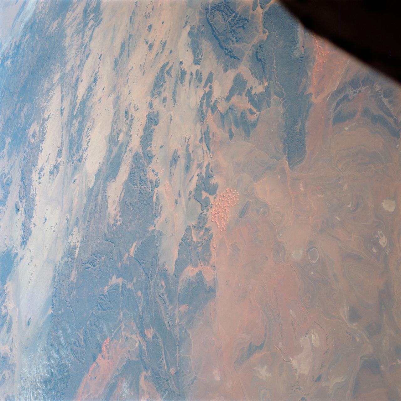
AST-02-130 (20 July 1975) --- An oblique view of a portion of Libya and the Arab Republic of Egypt, as photographed from the Apollo spacecraft in Earth orbit during the joint U.S.-USSR Apollo-Soyuz Test Project mission. The geological features are the Jebel Uweinat and Jebel Arkenu basaltic mountains in the Libyan sand sea. This picture was taken with a 70mm Hasselblad camera using medium-speed Ektachrome QX-807 type film. The spacecraft was at an altitude of 219 kilometers (136 statute miles).

AS07-04-1586 (20 Oct. 1968) --- Astronaut Walter Cunningham, Apollo 7 lunar module pilot, writes with space pen as he is photographed performing flight tasks on the ninth day of the Apollo 7 mission. Note the 70mm Hasselblad camera film magazine just above Cunningham's right hand floating in the weightless (zero gravity) environment of the spacecraft.
STS116-320-001 (9-22 Dec. 2006) --- Backdropped by the horizon of a blue and white Earth and the blackness of space, part of the Space Shuttle Discovery's aft cargo bay, its vertical stabilizer and orbital maneuvering system (OMS) pods are seen in this image photographed by an STS-116 crewmember onboard the shuttle. This image was recorded with a 35mm film-equipped camera.
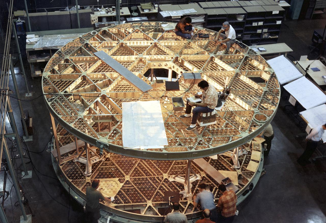
This photograph was taken during assembly of the bottom and upper floors of the Skylab Orbital Workshop (OWS). The OWS was divided into two major compartments. The lower level provided crew accommodations for sleeping, food preparation and consumption, hygiene, waste processing and disposal, and performance of certain experiments. The upper level consisted of a large work area and housed water storage tanks, a food freezer, storage vaults for film, scientific airlocks, mobility and stability experiment equipment, and other experimental equipment.

AST-30-2601 (20 July 1975) --- An area of the Cascade Mountains southeast of Seattle in the State of Washington, as photographed from the Apollo spacecraft in Earth orbit during the joint U.S.-USSR Apollo-Soyuz Test Project mission. The view includes Snoqualmie Pass, Cle Elum Lake, Kachess Lake and Keechelus Lake. The picture was taken at an altitude of 228 kilometers (141 statute miles) with a 70mm Hasselblad camera using medium-speed Ektachrome QX-807 type film.
S65-63926 (16 Dec. 1965) --- Island of Hispaniola, Dominican Republic end, as seen from the National Aeronautics and Space Administration's Gemini-7 spacecraft during its 179th revolution of Earth. North is toward the left of the picture. This photograph was taken with a modified 70mm Hasselblad camera, using Eastman Kodak, Ektachrome MS (S.O. 217) color film. Photo credit: NASA
S81-E-05468 (16 Jan. 1997) --- To protect it from exposure to light, astronaut John M. Grunsfeld, mission specialist, uses a black bag to change out a film magazine on a 70mm handheld camera during mid-week activity aboard the Space Shuttle Atlantis. The photograph was recorded with an Electronic Still Camera (ESC) and later was downlinked to flight controllers in Houston, Texas.
S66-54560 (14 Sept. 1966) --- U.S. Gulf coast area from Aransas Bay, Texas, to Mobile Bay, Alabama, as seen from the Gemini-11 spacecraft during its 29th revolution of Earth. The Galveston Bay and Houston area is in center of photograph. Further eastward along the coast can be seen the Mississippi River delta and New Orleans area. Taken with a modified 70mm Hasselblad camera, using Eastman Kodak, Ektachrome, MS (S.O. 368) color film. Photo credit: NASA
S66-54706 (14 Sept. 1966) --- Western half of Australia, including the coastline from Perth to Port Darwin, looking west, as seen from the Gemini-11 spacecraft during its 26th revolution of Earth. Photograph was made while the spacecraft was at a record-high apogee of 740 nautical miles. Taken with a modified 70mm Hasselblad camera, using Eastman Kodak, Ektachrome, MS (S.O. 368) color film. Photo credit: NASA
S65-64029 (13 Dec. 1965) --- Coast of British Guiana, South America, looking south, as seen from the National Aeronautics and Space Administration?s Gemini-7 spacecraft during its 135th revolution of Earth. This photograph was taken with a modified 70mm Hasselblad camera, using Eastman Kodak, Ektachrome MS (S.O. 217) color film. Photo credit: NASA
S66-54555 (14 Sept. 1966) --- The Gemini-11 spacecraft is docked to the Agena Target Vehicle in this photograph taken by astronaut Richard F. Gordon Jr., pilot, as he stood in the open hatch of the Gemini-11 spacecraft during his extravehicular activity (EVA). Note Agena's L-band antenna. Taken during Gemini-11's 29th revolution of Earth, using a modified 70mm Hasselblad camera, with Eastman Kodak, Ektachrome, MS (S.O. 368) color film. Photo credit: NASA
STS048-05-024 (15 Sept 1991) --- The Upper Atmosphere Research Satellite (UARS), in the grasp of the Remote Manipulator System (RMS), was captured on film by a camera aimed through one of the Space Shuttle Discovery's overhead windows. At the time of the photo, deployment of UARS' solar array panel was in progress. A few hours later, the huge satellite was free and on its way to a higher orbit. Data from UARS will enable scientists to study ozone depletion in the stratosphere, or upper atmosphere. The image was photographed with a 35mm camera.
SL3-121-2445 (July-September 1973) --- An oblique view of a portion of Great Britain looking northeastward across England and Wales, as photographed by one of the Skylab 3 crewmen aboard the Skylab space station in Earth orbit. The picture was taken with a hand-held 70mm Hasselblad camera using a 100mm lens and SO-368 medium-speed Ektacrome film. The English Channel is at lower right. The Bristol Channel is at lower left. The North Sea with much cloud cover is in the background. Photo credit: NASA
S65-63784 (7 Dec. 1965) --- Algeria, south of Celemb Bechar, as seen from the orbiting Gemini-7 spacecraft during its 42nd revolution of Earth. Note rain runoff on the desert floor. Astronaut Frank Borman and James A. Lovell Jr. were aboard the National Aeronautics and Space Administration?s Gemini-7 spacecraft. The photograph was taken with a modified 70mm Hasselblad camera, using Eastman Kodak, Ektachrome MS (S.O. 217) color film. Photo credit: NASA
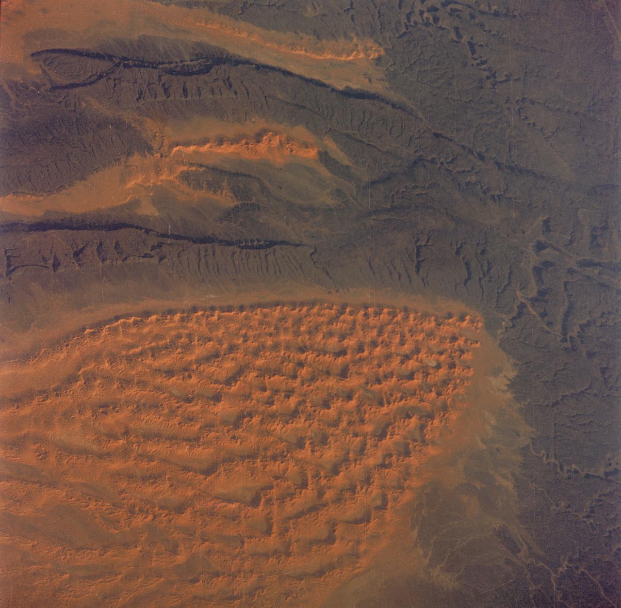
AST-27-2341 (20 July 1975) --- A near vertical view of sand dunes in the San Juan Province of Western Argentina, as photographed from the Apollo spacecraft in Earth orbit during the joint U.S.-USSR Apollo-Soyuz Test Project mission. The picture was taken at an altitude of 220 kilometers (136 statute miles) with a 70mm Hasselblad camera using medium-speed Ektachrome QX-807 type film.
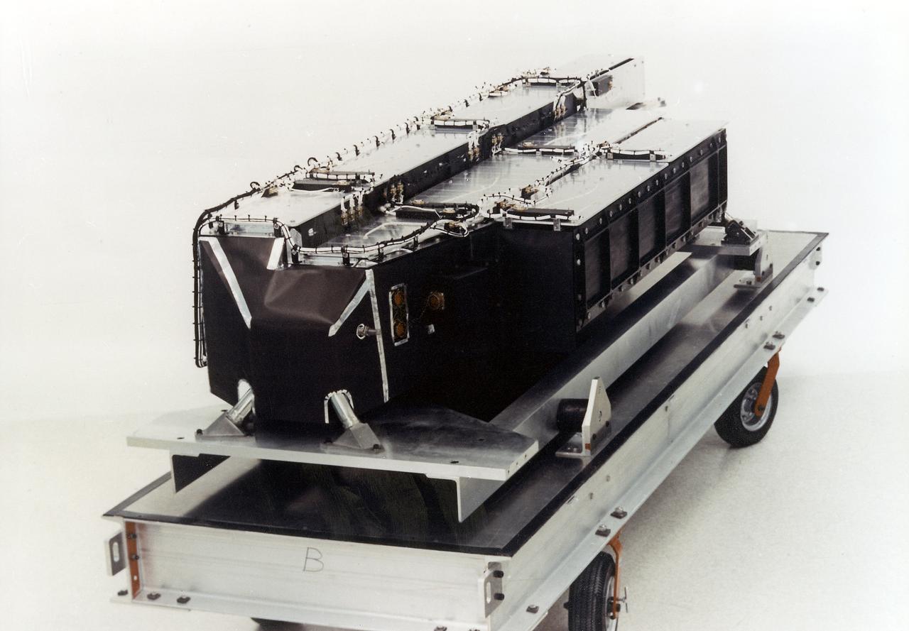
Lunar Orbiter was essentially a flying camera. The payload structure was built around a pressurized shell holding Eastman Kodak s dual-imaging photographic system, which used a camera with wide-angle and telephoto lenses that could simultaneously take two kinds of pictures on the same film. Men in in the picture are: Right to left Cliff Nelson, Calvin Broome, Israel Taback and Joe Mooreman. -- Published in James R. Hansen, Spaceflight Revolution: NASA Langley Research Center From Sputnik to Apollo, NASA SP-4308, p. 329.
S70-41982 (June 1970) --- Sequence photo from 16mm motion picture film of test at National Aeronautics and Space Administration's Langley Research Center which seeks to determine mechanism by which Apollo 13 panel was separated from the Service Module. Test used a 1/2 scale model with a honeycomb sandwich panel and was conducted in a vacuum. (First of three photographs in sequence). Photo credit: NASA
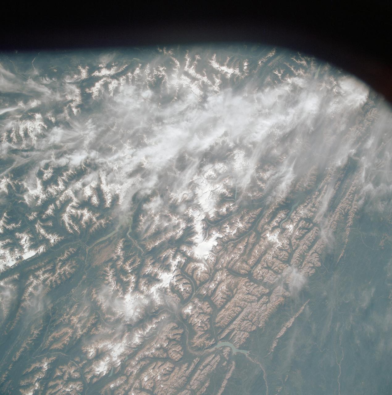
AST-19-1570 (24 July 1975) --- An oblique view of the Rocky Mountains area of British Columbia and Alberta in Canada, as photographed from the Apollo spacecraft in Earth orbit during the joint U.S.-USSR Apollo-Soyuz Test Project mission. This picture was taken at an altitude of 222 kilometers (138 statute miles) with a 70mm Hasselblad camera using medium-speed Ektachrome QX-807 type film.
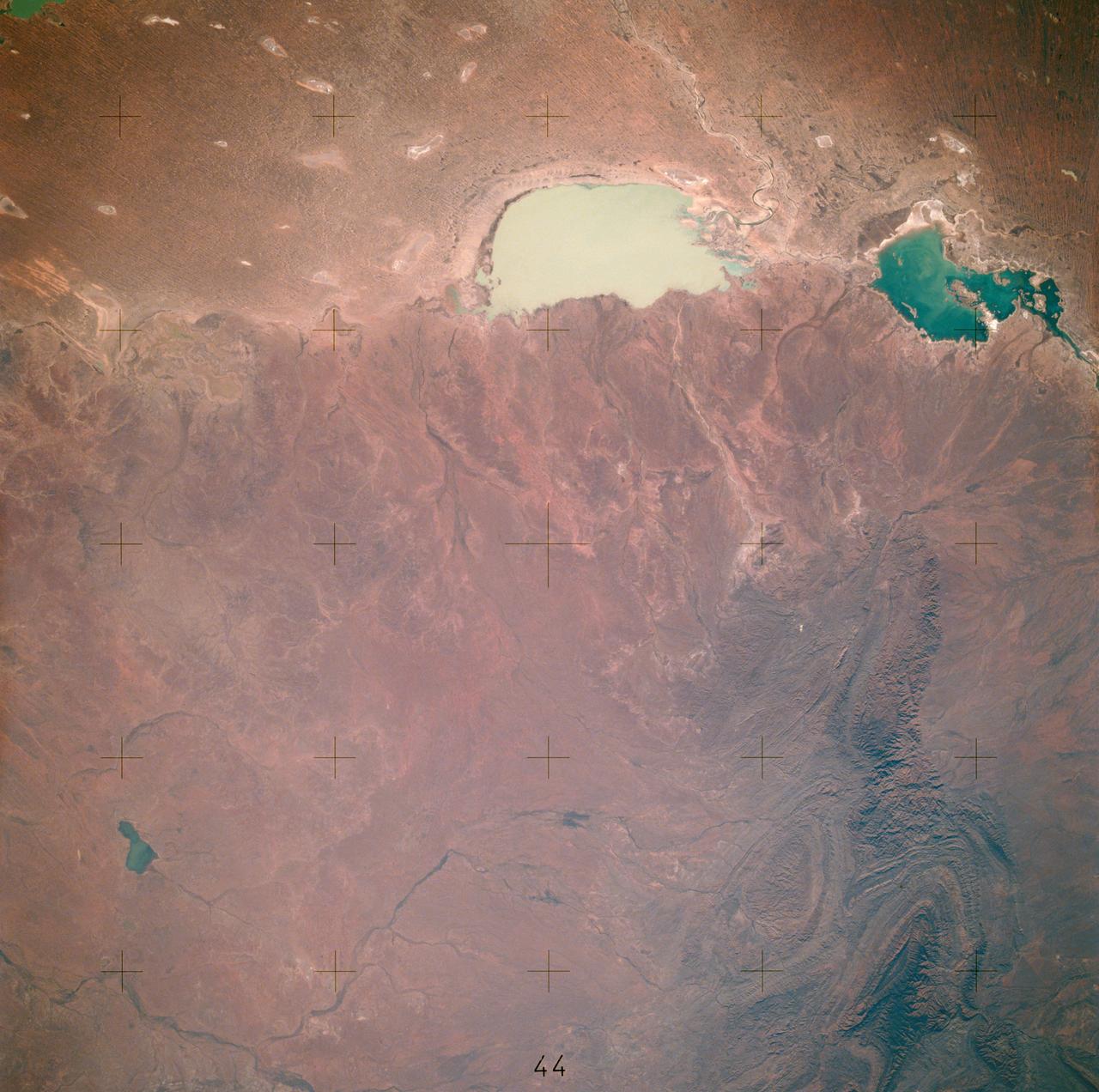
AST-16-1132 (20 July 1975) --- A vertical view of the eastern portion of the state of South Australia in Australia, as photographed from the Apollo spacecraft in Earth orbit during the joint U.S.-USSR Apollo-Soyuz Test Project mission. The highlands area is the Flinders Range. The light-colored body of water is Lake Blanche. The lake to the south is Callabonna. This picture was taken at an altitude of 224 kilometers (139 statute miles) with a 70mm Hasselblad camera using high-definition aerial Ektachrome SO-242 type film.
S65-63829 (5 Dec. 1965) --- Algeria, south of the Fort Flatters area, as seen from the National Aeronautics and Space Administration?s Gemini-7 spacecraft during its 13th revolution of Earth. The orange color area is the Tifermine Sand Dunes that reach a height of 1,000 feet. The photograph was taken with a modified 70mm Hasselblad camera, with Eastman Kodak, Ektachrome MS (S.O. 217) color film. Photo credit: NASA
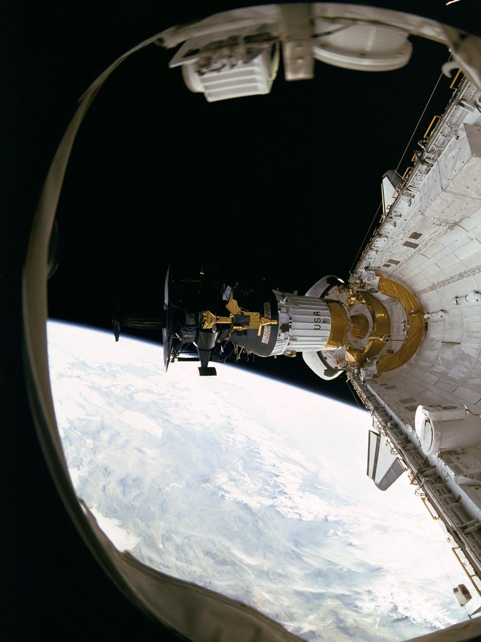
S71-43202 (5 Aug. 1971) --- Astronaut Alfred M. Worden, command module pilot of the Apollo 15 lunar landing mission, floats in space outside the spacecraft during his trans-Earth extravehicular activity (EVA). This photograph was taken from a frame of motion picture film exposed by the 16mm Maurer camera mounted in the hatch of the Command Module (CM). During his EVA, Worden made an inspection of the Service Module's (SM) Scientific Instrument Module (SIM) bay and retrieved the film cassettes from the Panoramic Camera and the Mapping Camera. The SIM bay holds eight orbital science experiments. The EVA occurred when the spacecraft was homeward bound approximately 171,000 nautical miles from Earth.
S89-48714 (18 Oct 1989) --- This photograph was taken by the STS-34 crew aboard the Space Shuttle Atlantis and shows the Galileo spacecraft being deployed on Oct. 18, 1989 from the payload bay. Galileo is a scientific craft that will go into orbit around the planet Jupiter and drop a probe into its atmosphere in search of primordial solar system material believed to be present there. The 70mm motion picture film will be used in the forthcoming "Blue Planet," which will address Earth's environmental problems from the perspective of space-based observation and solar system exploration. The film is being produced by IMAX Space Technology Inc. for the sponsor, the Smithsonian Institution, with funding provided by the Lockheed Corporation. PHOTO CREDIT: NASA/Smithsonian Institution
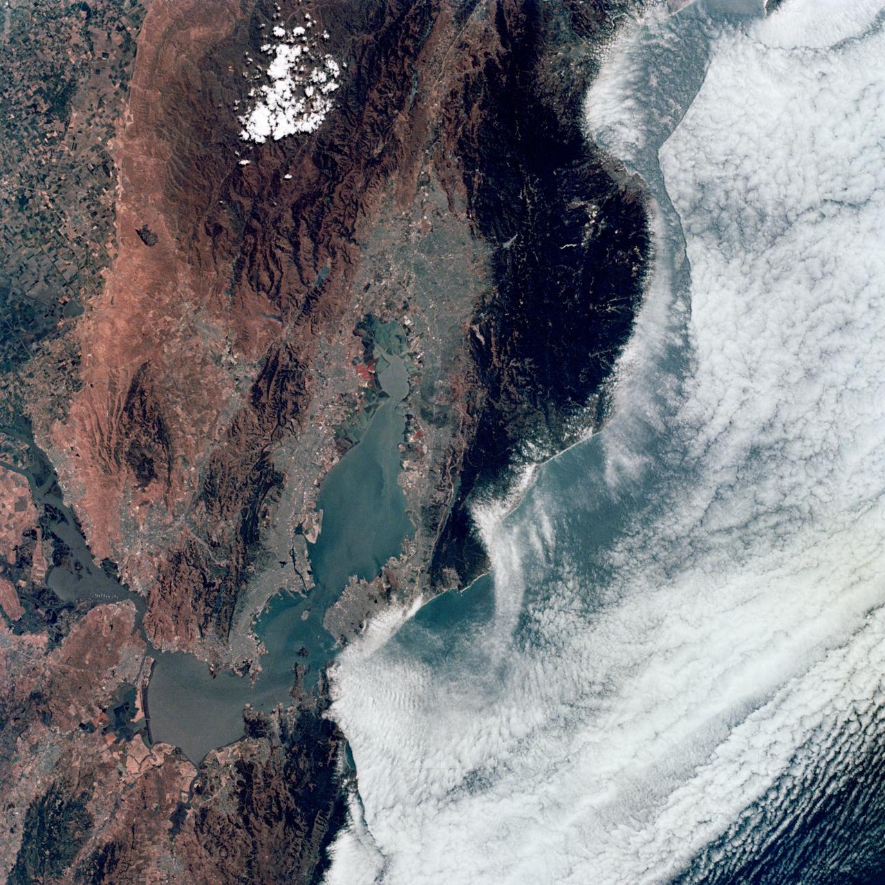
SL2-04-118 (June 1973) --- A color photograph of the San Francisco Bay, California area, taken from the Skylab space station in Earth orbit. (The picture should be held with the clouds and Pacific Ocean on the left.) Note the thickly populated and highly developed area around the bay. Among the cities visible are San Francisco, Oakland, Berkeley and San Jose. This view extends eastward to show a portion of the San Joaquin Valley. This photograph was taken by one of the six lenses of the Itek-furnished S190-A Multispectral Photographic Facility Experiment in the Multiple Docking Adapter of the space station. Type SO-356 film was used. The S190-A experiment is part of the Skylab Earth Resources Experiments Package (EREP). Photo credit: NASA
AS6-02-1485 (4 April 1968) --- View of the east coast of the United States as photographed from the National Aeronautics and Space Administration's unmanned Apollo 6 (Spacecraft 020/Saturn 502) space mission. This photograph was taken during a pass over Georgia, between Savannah and Brunswick. Altitude of the spacecraft was 100 nautical miles. Numerous jet aircraft contrails can be seen over the Atlantic Ocean. Sun glint on the surface of the ocean permits oceanographers to determine conditions of the water. This photograph was taken April 4, 1968, three hours and 14 minutes after liftoff, using Eastman Kodak SO-121 high resolution aerial Ektachrome film (exposure setting f/5.6 at 1/500 second), in a J. A. Maurer model 220G camera.
AS06-02-1436 (4 April 1968) --- View of the mouth of the Colorado River and the Gulf of California in northwestern Mexico as photographed from the unmanned Apollo 6 (Spacecraft 020/Saturn 502) space mission. Altitude of the spacecraft at the time picture was taken was 120 nautical miles. NORTH IS TOWARD LEFT SIDE OF PICTURE. At bottom edge of photograph is Baja California. In the upper left corner is the Mexican state of Sonora showing the Sonoran Desert and the Pinacate Mountains. This photograph was made three hours and seven minutes after liftoff using Eastman Kodak SO-121 high resolution aerial Ektachrome film (exposure setting was f/5.6 at 1/500 second) in a J.A. Maurer model 2200 camera.
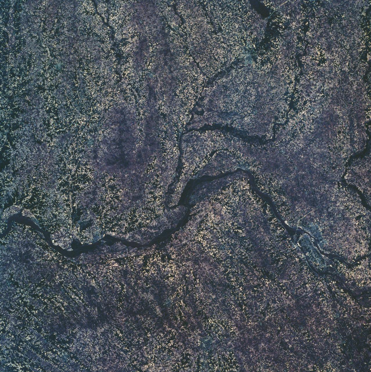
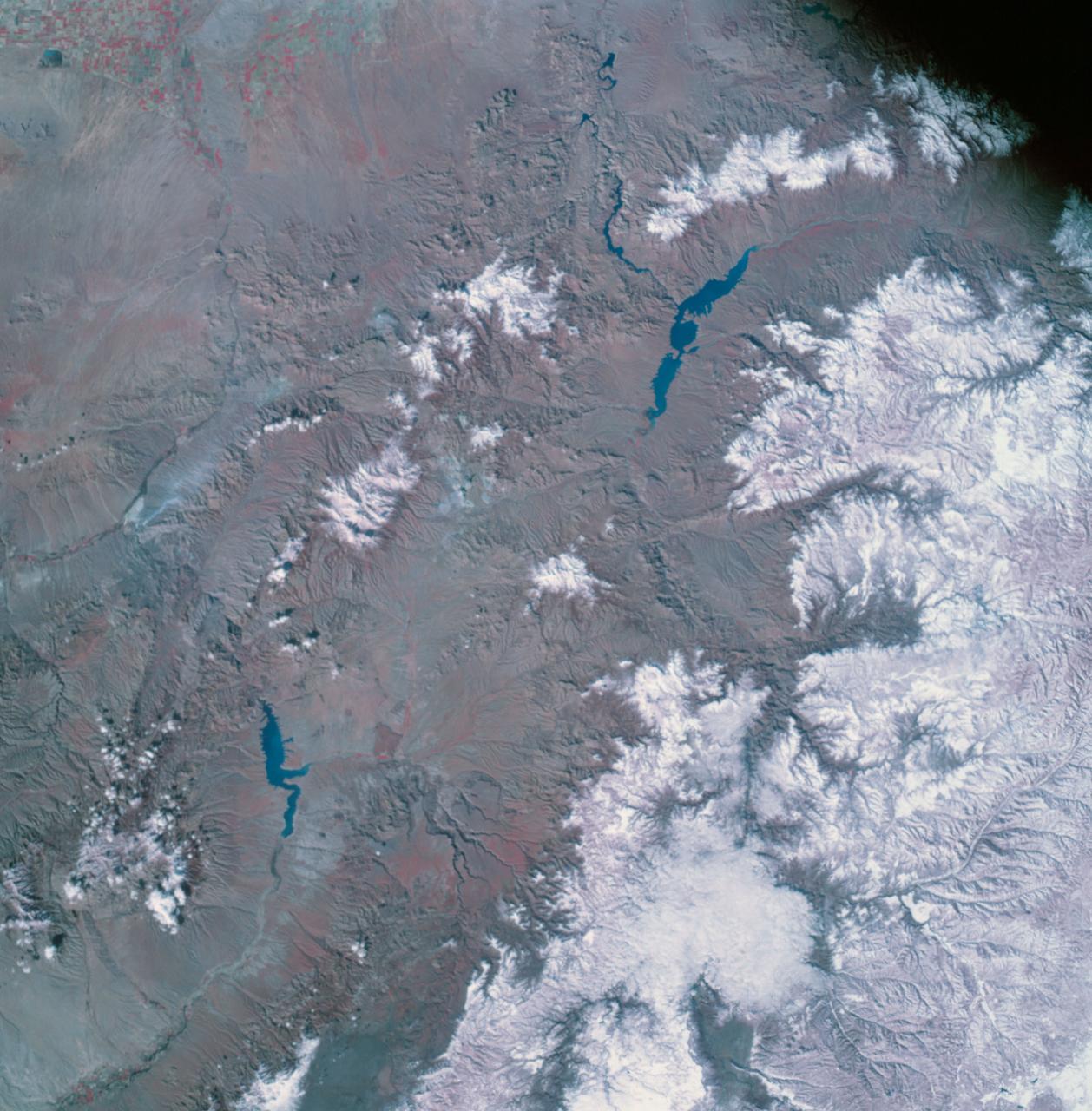
SL2-10-250 (May-June 1973) --- A vertical view of eastern Iowa and northwestern Illinois, as photographed from Skylab space station in Earth orbit. Davenport, Burlington and Muscatine, Iowa; and Rock Island and Moline, Illinois can be delineated on opposite sides of the Mississippi River. The Iowa River and tributaries of it can also be delineated. This photograph was taken with one of six lenses of the Itek-furnished Multispectral Photographic Facility Experiment S190-A mounted in the Multiple Docking Adapter (MDA) of the space station. A six-inch lens, using 70mm medium speed Ektachrome (SO-356) film, was used. Agencies participating with NASA on the EREP project are the Departments of Agriculture, Commerce and Interior; the Environmental Protection Agency and the Corps of Engineers. All EREP photography is available to the public through the Department of Interior's Earth Resources Observations Systems Data Center, Sioux Falls, South Dakota, 57198. Photo credit: NASA
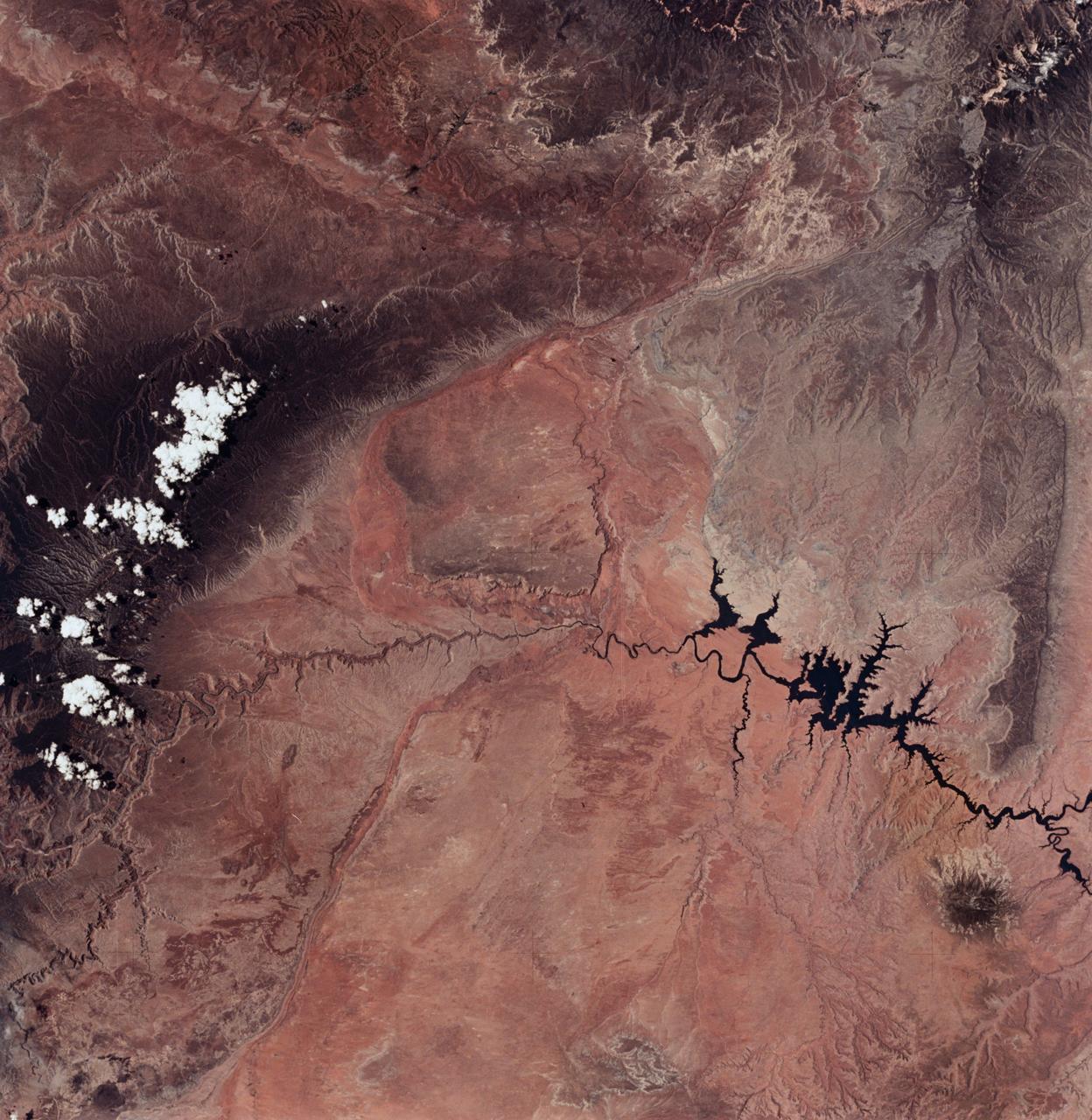
SL2-04-018 (June 1973) --- A vertical view of the Arizona-Utah border area showing the Colorado River and Grand Canyon photographed from the Skylab 1/2 space station in Earth orbit. This picture was taken by one of the six lenses of the Itek-furnished S190-A Multispectral Photographic Facility Experiment in the Multiple Docking Adapter of the space station. Type S0-356 film was used. The row of white clouds extend north-south over the dark colored Kaibab Plateau. The junction of the Colorado and Little Colorado rivers is in the southwest corner of the picture. The body of water is Lake Powell on the Colorado River upstream from the Grand Canyon. The lone peak at the eastern edge of the photograph south of Colorado River is the 10,416-foot Navajo Mountain. The S190-A experiment is part of the Skylab Earth Resources Experiments Package(EREP). Photo credit: NASA
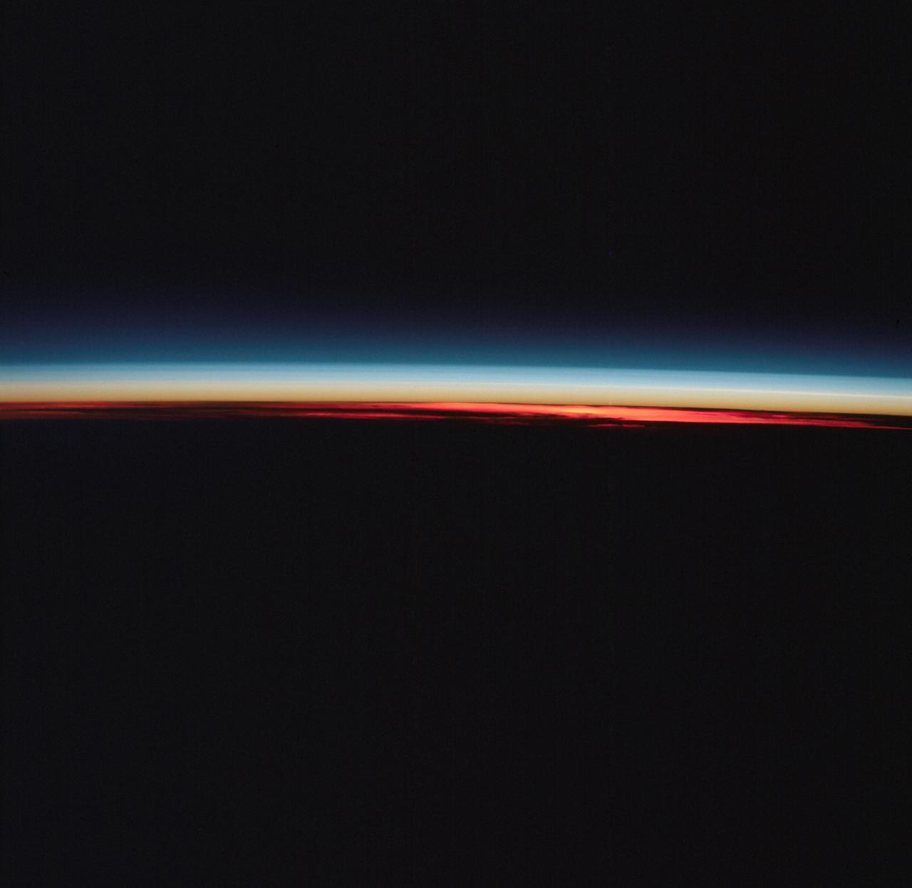
STS083-748-006 (4-8 April 1997) --- This type of scene is seen about every 45 minutes as the astronauts travel around the world. Sunrises and sunsets differ in structure, since the tropopause altitude and atmospheric lamina temperatures vary with time of day, season, and latitude. Close analysis of these terminator photographs provide counts of the number and spacing of atmospheric laminae. In the photographs, as many as 4 laminae have been noted in the normally red-to-orange troposphere, and up to 12 laminae have been counted in the blue upper atmosphere. However, true replication of human vision is not possible using present films. For instance, while on orbit, one astronaut counted 22 layers. The photograph of that event recorded only 8 such layers.

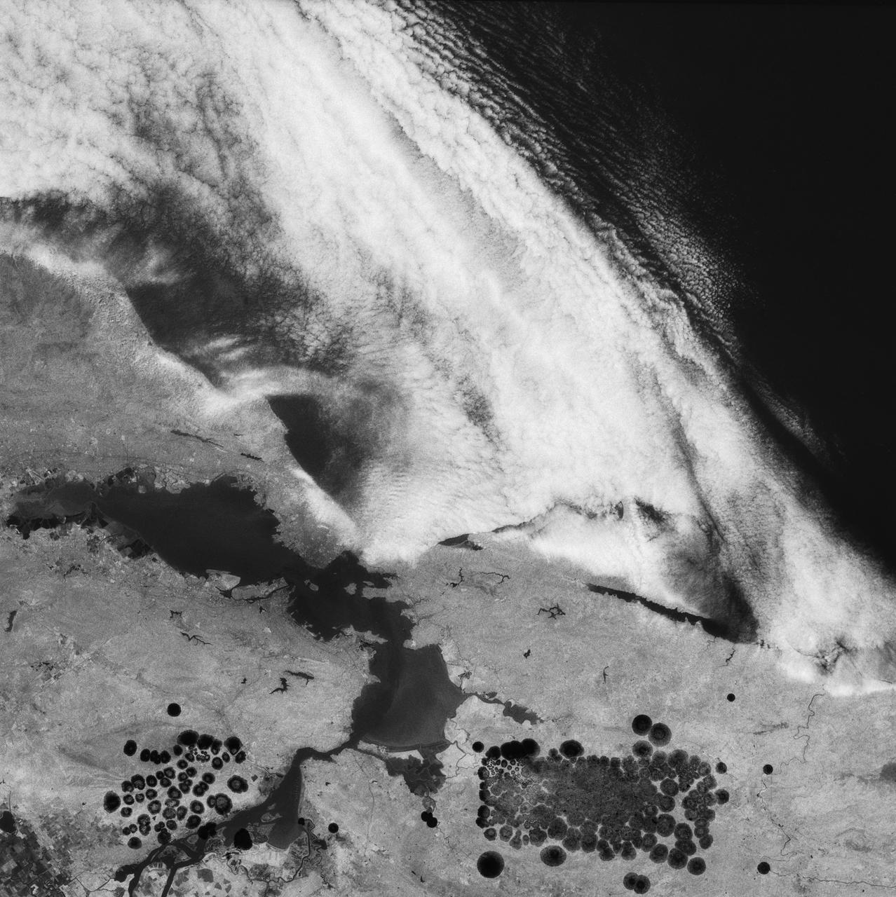
SL4-136-3388 (2 Dec. 1973) --- This excellent view of a South Pacific storm was photographed from the Skylab space station in Earth orbit by one of the Skylab 4 crewmen. The camera used was a hand-held 70mm Hasselblad, with SO-368 medium-speed Ektachrome film. This photograph of a low pressure area and associated frontal activity was taken for studying the development of such storm systems. The low sun angle enhances the relief, giving much of the picture a three-dimensional appearance. The good definition of the clouds with the cumulonimbus (thunderstorm clouds) penetrating the cirrus cloud layer makes this an interesting photograph to study. This storm, located east of New Zealand at 170 degrees west longitude and 50 degrees south latitude, is not and never became a typhoon. However, in some ways it may look similar. Photo credit: NASA