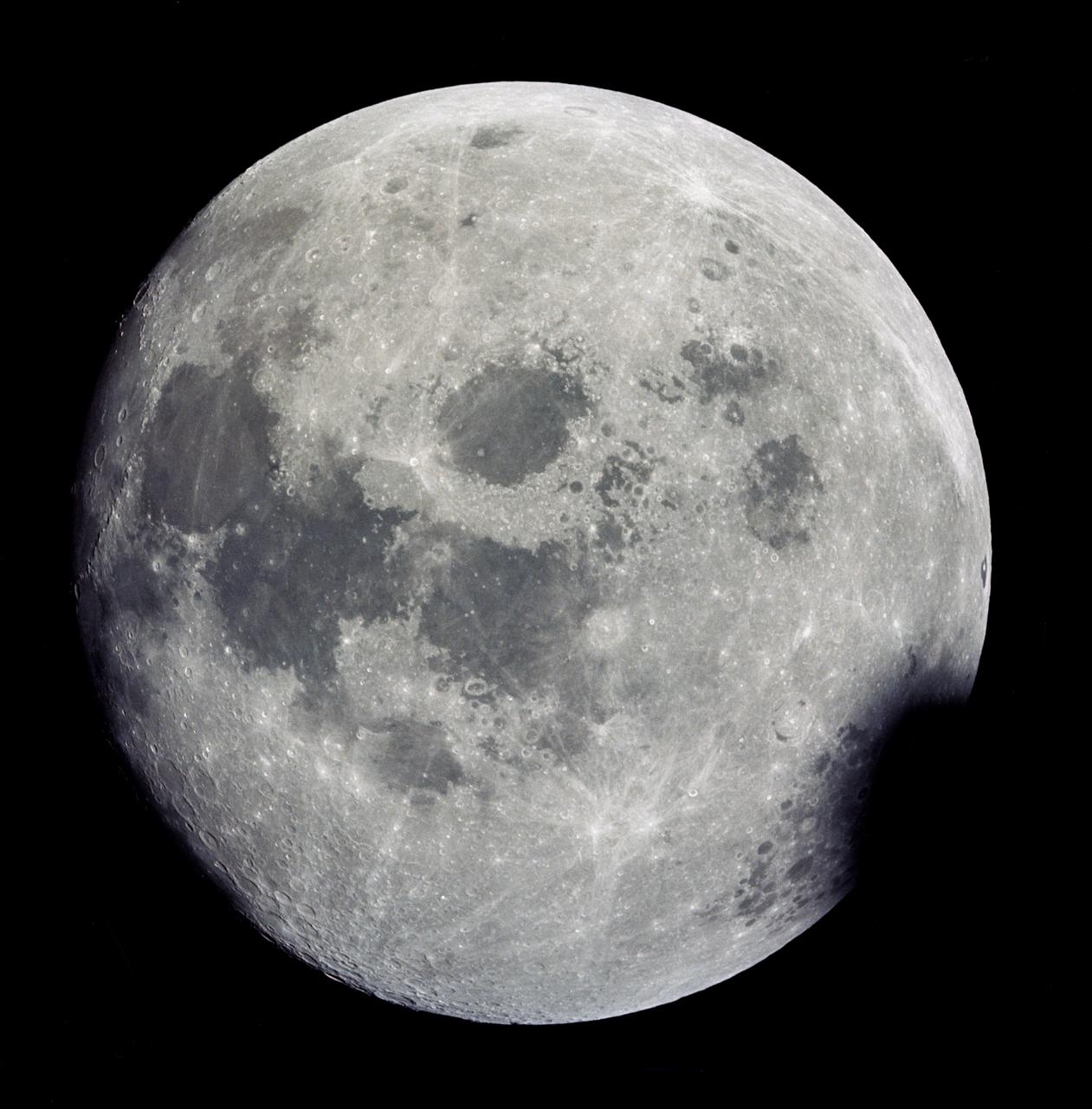
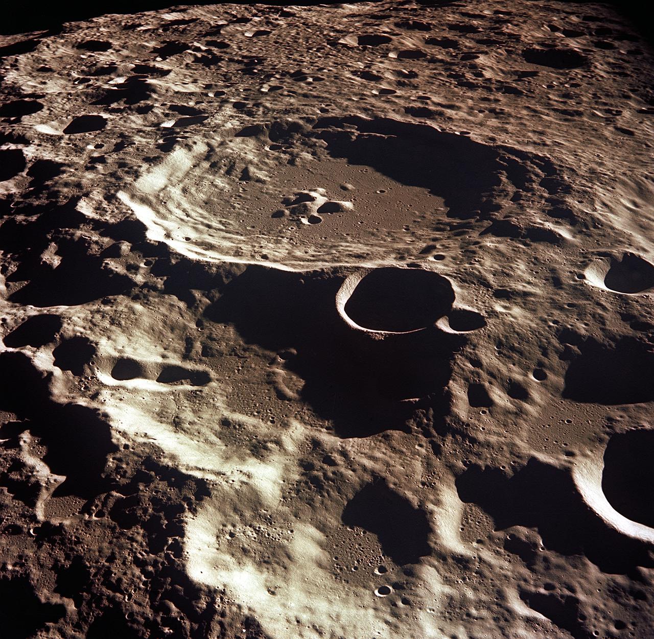
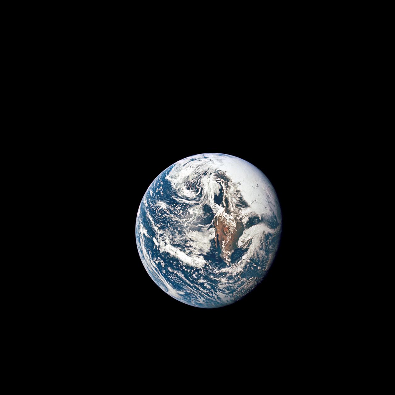
AS13-60-8703 (11-17 April 1970) --- This outstanding view of a near full moon was photographed from the Apollo 13 spacecraft during its trans-Earth journey homeward. Though the explosion of the oxygen tank in the Service Module (SM) forced the cancellation of the scheduled lunar landing, Apollo 13 made a pass around the moon prior to returning to Earth. Some of the conspicuous lunar features include the Sea of Crisis, the Sea of Fertility, the Sea of Tranquility, the Sea of Serenity, the Sea of Nectar, the Sea of Vapors, the Border Sea, Smyth's Sea, the crater Langrenus, and the crater Tsiolkovsky.
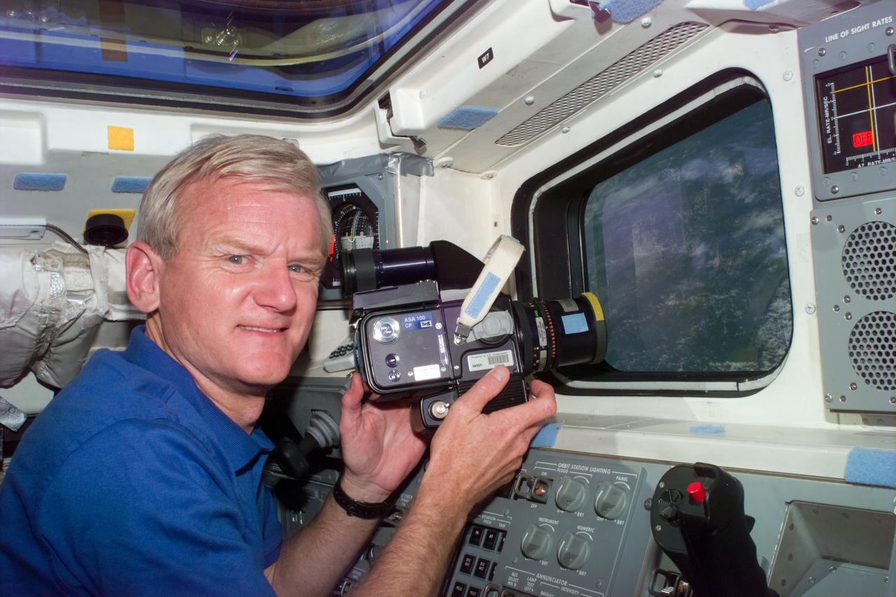
S77-E-5109 (26 May 1996) --- Astronaut John H. Casper, commander, pauses during a photography session on the aft flight deck of the Space Shuttle Endeavour. The scene was recorded with an Electronic Still Camera (ESC).
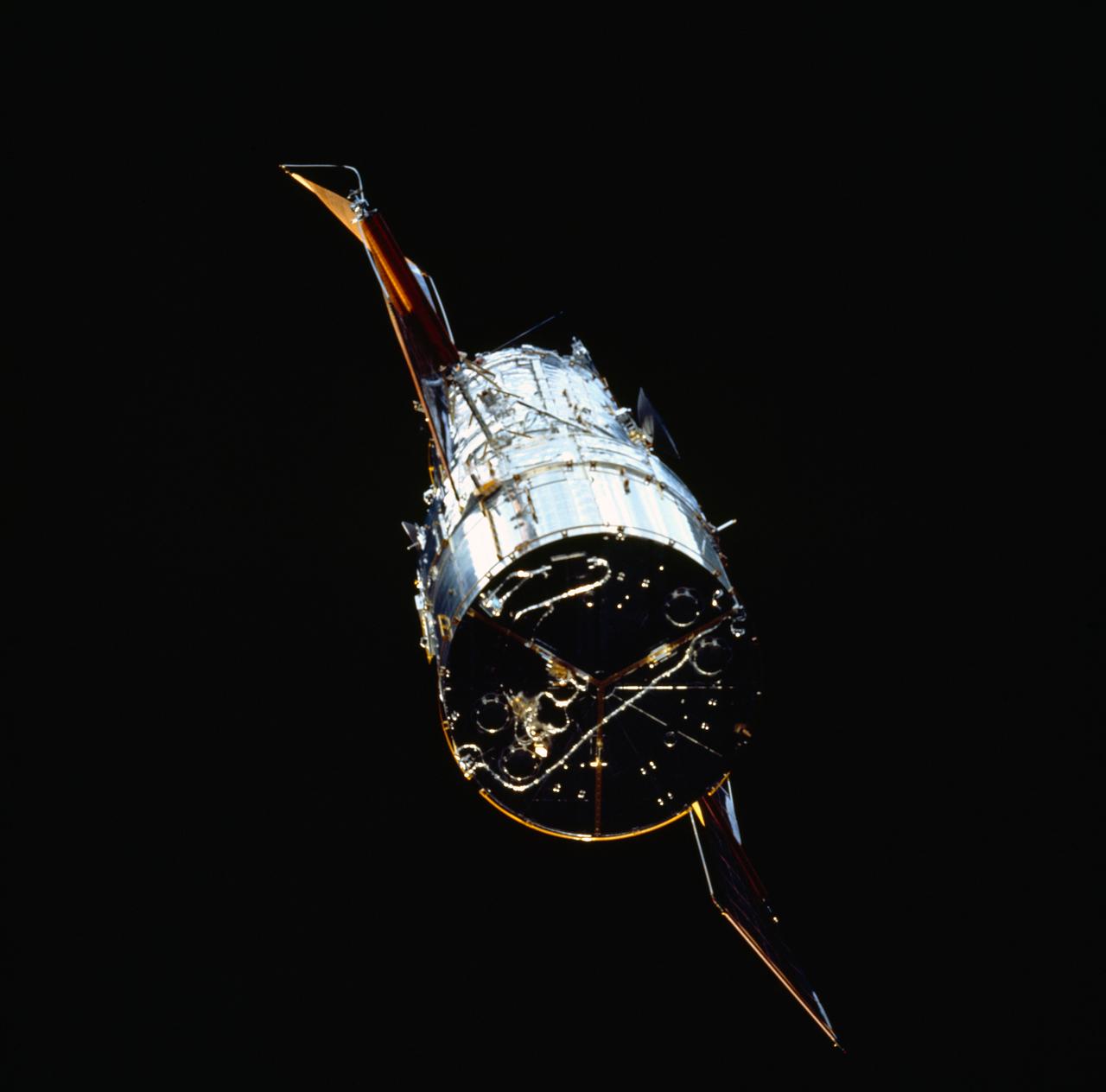
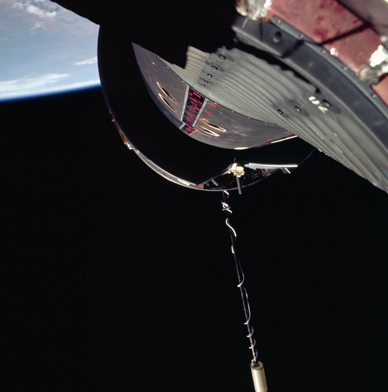
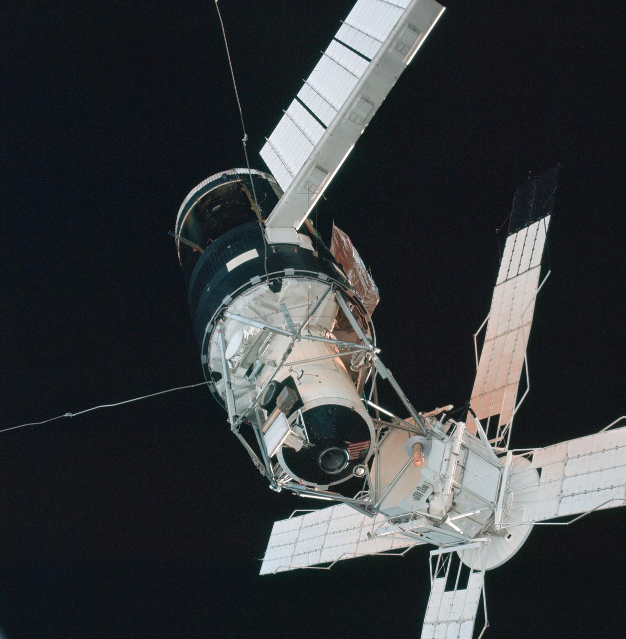
STS061-73-040 (4 Dec 1993) --- Backdropped against the blackness of space, the Hubble Space Telescope (HST) nears the Space Shuttle Endeavour. With the aid of the Remote Manipulator System (RMS), the STS-61 crew members later grappled the spacecraft and berthed it in the cargo bay for five-days of servicing chores by four space walkers.
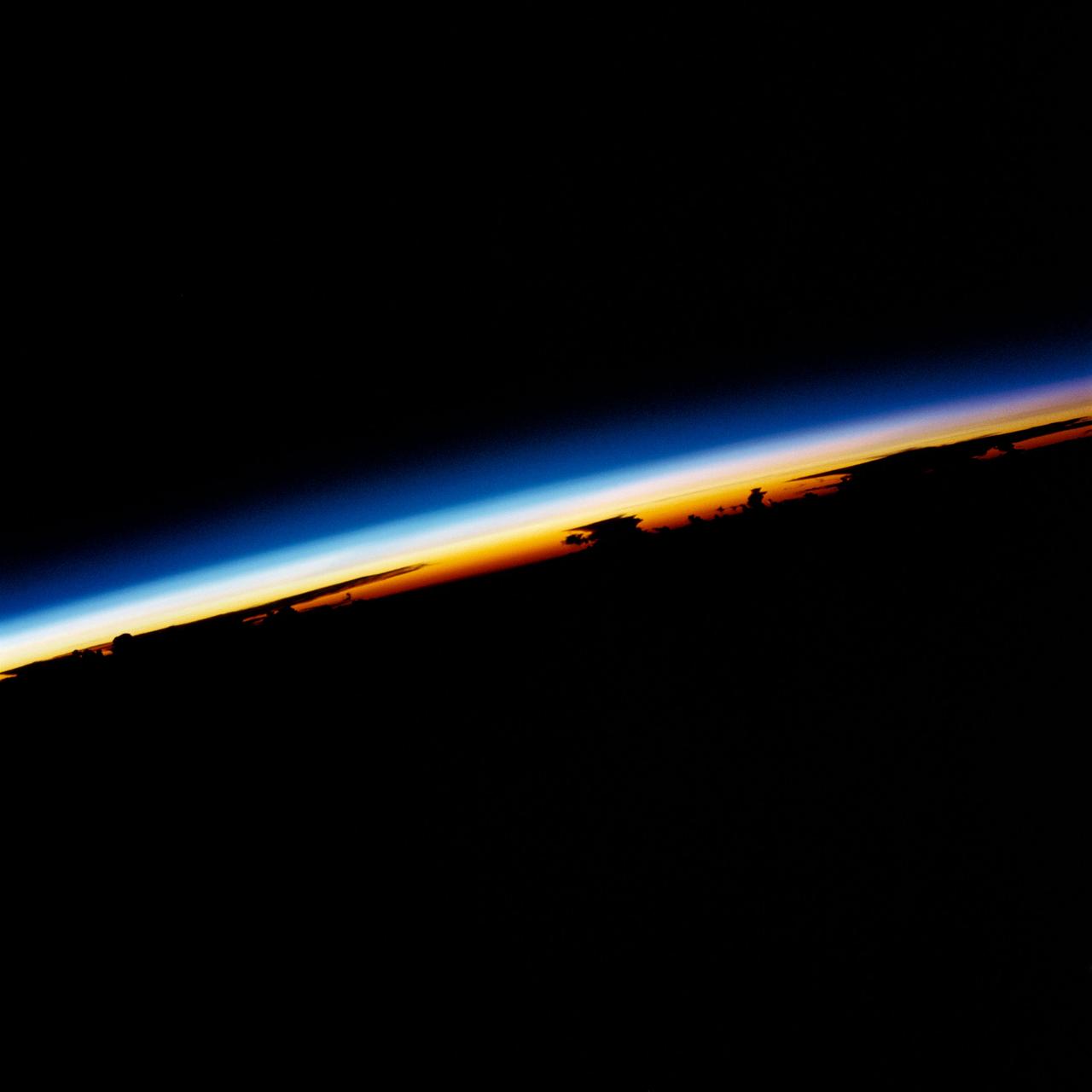
41D-32-14 (30 Aug 1984) --- A rainbow-like sunrise over the Philippine Sea greeted the six crew members aboard the Earth-orbiting Space Shuttle Discovery on its first day in space. A 70mm camera was used to record the scene at 3:08:14 p.m. (CDT), August 30, 1984, during Discovery's sixth orbit of a six-day mission. The spacecraft was above a position on Earth centered at 21.1 degrees north and 12.9 degrees east (about 250 miles north - northeast of the Philippine Islands). The scene was shown as one of the Post-Flight Press Conference (PFPC) visuals by the crew on September 12, 1984.

STS075-351-022 (22 Feb.- 9 March 1996) --- The space shuttle Columbia's vertical stabilizer appears to point to the four stars of the Southern Cross. The scene was captured with a 35mm camera just prior to a sunrise. The seven member crew was launched aboard the space shuttle Columbia on Feb. 22, 1996, and landed on March 9, 1996. Crew members were Andrew M. Allen, mission commander; Scott J. Horowitz, pilot; Franklin R. Chang-Diaz, payload commander; and Maurizio Cheli, European Space Agency (ESA); Jeffrey A. Hoffman and Claude Nicollier, ESA, all mission specialists; along with payload specialist Umberto Guidoni of the Italian Space Agency (ASI).
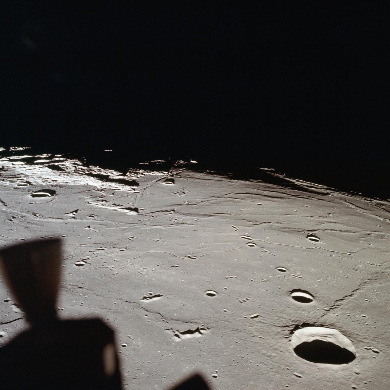
AS11-37-5437 (20 July 1969) --- The approach to Apollo Landing Site 2 in southwestern Sea of Tranquility is seen in this photograph taken from the Apollo 11 Lunar Module (LM) in lunar orbit. When this picture was made, the LM was still docked to the Command and Service Modules (CSM). Site 2 is located just right of center at the edge of the darkness. The crater Maskelyne is the large one at the lower right. Hypatia Rille (U.S. 1) is at upper left, with the crater Moltke just to the right (north) of it. Sidewinder Rille and Diamondback Rille extend from left to right across the center of the picture. This view looks generally west.
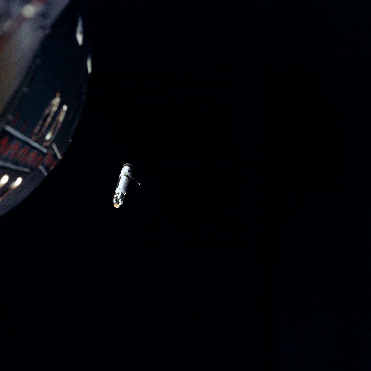
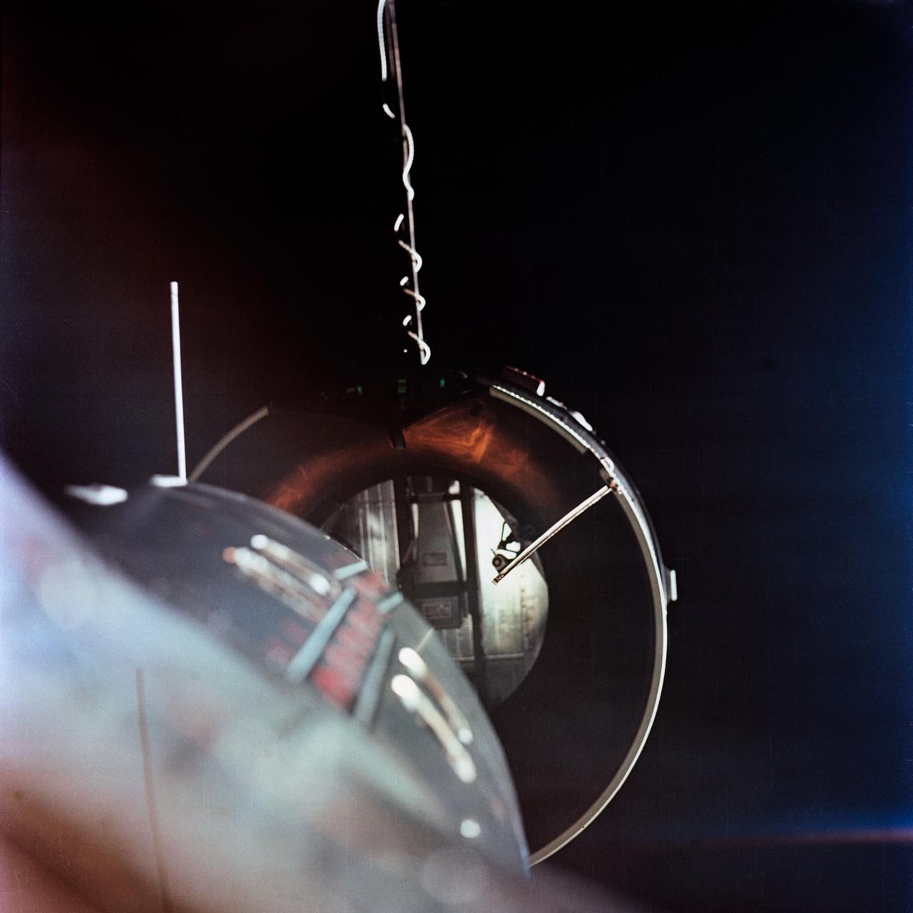
S66-54656 (13 Sept. 1966) --- Nose of Gemini-11 spacecraft and Agena Target Vehicle while docked as photographed by astronaut Richard F. Gordon Jr., pilot, during his stand-up extravehicular activity (EVA). Taken with a modified 70mm Hasselblad camera, using Eastman Kodak, Ektachrome, MS (S.O. 368) color film. Photo credit: NASA
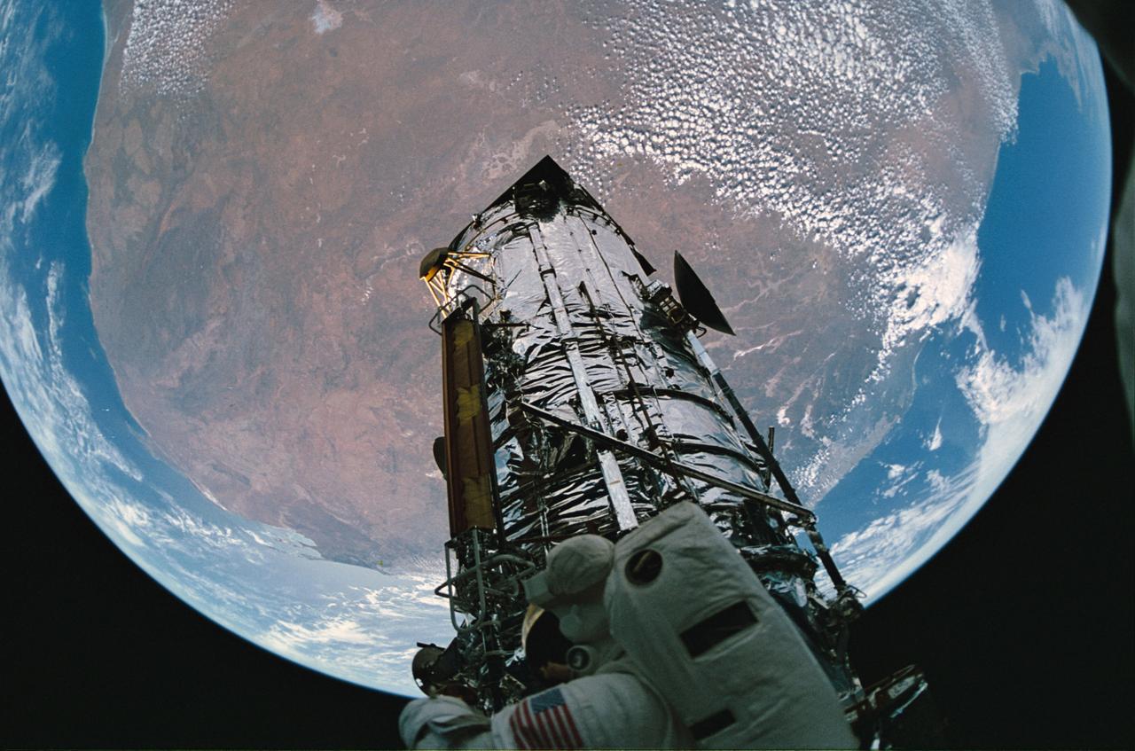
STS061-65-015 (9 Dec 1993) --- A fish-eye lens was used to capture the Hubble Space Telescope (HST), a spherical Earth and Australian landmass with a bit of distortion during the final extravehicular activity (EVA) on the STS-61 HST-servicing mission. Astronaut F. Story Musgrave can be seen at bottom of the frame.
STS064-310-005 (16 Sept. 1994) --- Astronaut Richard N. Richards, STS-64 commander, looks through one of the space shuttle Discovery's overhead flight deck windows to view the Extravehicular Activity (EVA) activities of astronauts Carl J. Meade, who took this picture, and Mark C. Lee. Wearing spacesuits in and around the space shuttle Discovery's cargo bay, astronauts Meade and Lee took turns trying out the new EVA test hardware called Simplified Aid for EVA Rescue (SAFER). Photo credit: NASA or National Aeronautics and Space Administration
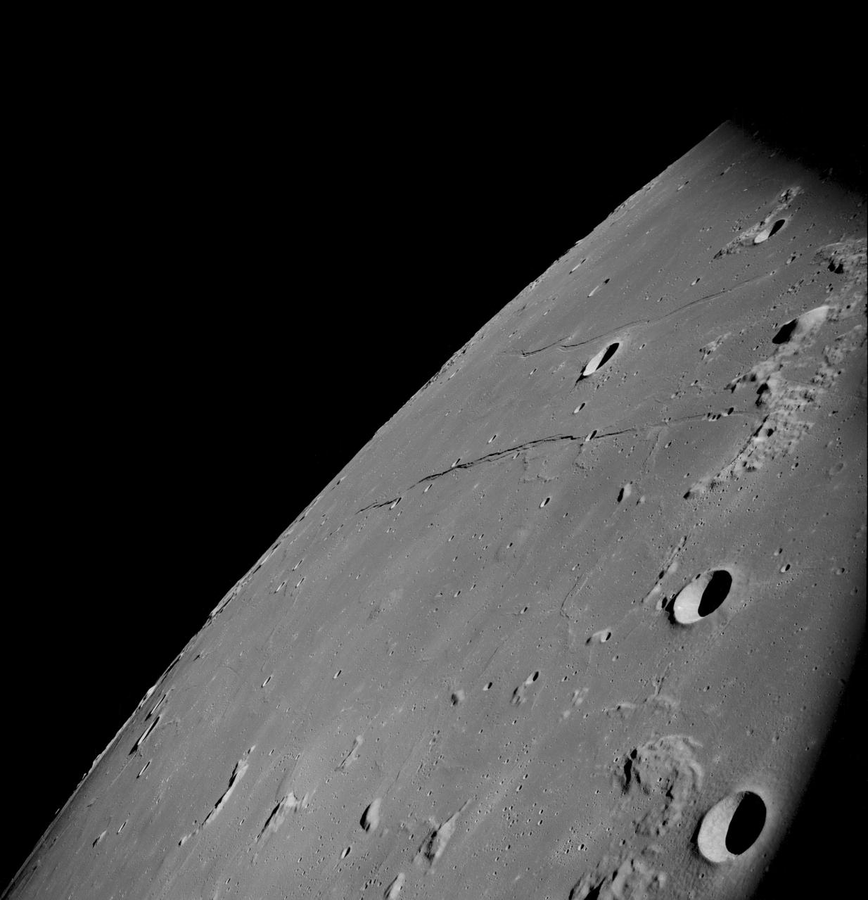
AS11-43-6412 (July 1969) --- This is a northeasterly, low-oblique view of an unmanned crater and highland area on the lunar farside, as photographed from Apollo 11. The center of the picture is located at the 167 degrees east longitude and 6 degrees north latitude. This area of the moon lies just east of International Astronomical Union crater No. 220.
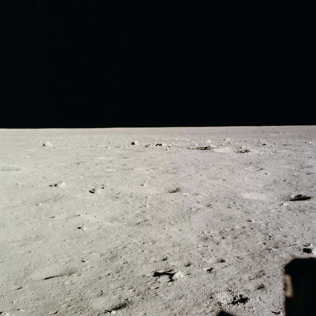
AS11-37-5458 (20 July 1969) --- This excellent view from the right-hand window of the Apollo 11 Lunar Module (LM) shows the surface of the moon in the vicinity of where the LM touched down. Numerous small rocks and craters can be seen between the LM and the lunar horizon. Astronaut Michael Collins, command module pilot, remained with the Command and Service Modules (CSM) in lunar orbit while astronauts Neil A. Armstrong, commander; and Edwin E. Aldrin Jr., lunar module pilot, descended in the LM to the lunar surface.
AS11-43-6439 (July 1969) --- An Apollo 11 oblique view of the lunar farside. The linear group of small craters is located within the large International Astronomical Union crater No. IX, and is centered at 139.5 degrees east longitude and 7 degrees north latitude. The absence of shadows is due to the high sun angle. The crater chain is approximately 34 statute miles in length, and the large crater adjacent to the crater is 10.5 statute miles in diameter.
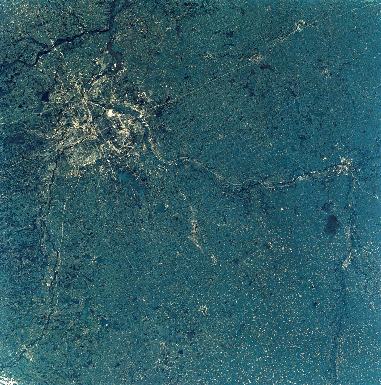
SL3-28-009 (July-September 1973) --- A near vertical view of the Minneapolis-St. Paul, Minnesota area, as photographed from Earth orbit by one of the six lenses of the Itek-furnished S190-A Multispectral Photographic Facility Experiment in the Multiple Docking Adapter of the Skylab space station. A 150mm lens, with SO-356 high definition Ektachrome film, was used to take this picture. The Mississippi River flows southeasterly through this large metropolitan area. Minneapolis is on the west bank of the Mississippi. The Minnesota River makes a large bend at the southern edge of the picture then flows northeasterly to empty into the Mississippi at Minneapolis-St. Paul. The St. Croix River, which serves as a portion of the boundary between Minnesota and Wisconsin, flows into the Mississippi downstream from the twin cities. A long, nearly straight, stretch of Interstate 35 leads southward from Minneapolis-St. Paul. Interstate 94 parallels the Mississippi toward the northwest. The highway and road network in the area is clearly visible. Note the numerous small lakes in the photograph. This view includes the smaller cities of Hastings, Faribault, Owatonna, Mankato, St. Peter, New Ulm and St. Cloud. The S190-A experiment is part of the Skylab Earth Resources Experiments Package. Photo credit: NASA
AS11-42-6285 (July 1969) --- An Apollo 11 view of a bright rayed crater on the lunar farside. The crater is unnamed. The center of this photograph is located at 100 degrees southeast longitude and 4 degrees 30 minutes north latitude. This area is just east of Smyth's Sea.
AS11-42-6248 (July 1969) --- An Apollo 11 oblique view of the lunar farside in the area of International Astronomical Union crater No. 312, which is about 30 statute miles in diameter. The center of the photograph is located at 164 degrees west longitude and 8 degrees south latitude. The sharp shadows indicate that the picture was taken at a low sun angle.
AS11-42-6237 (20 July 1969) --- An Apollo 11 oblique view of the large crater Theophilus located at the northwest edge of the Sea of Nectar on the lunar nearside. Theophilus is about 60 statute miles in diameter. The smooth area is Mare Nectaris. The smaller crater Madler, about 14 statute miles in diameter, is located to the east of Theophilus. Visible in the background are the large crater Fracastorius and the smaller crater Beaumont. The coordinates of the center of this photograph are 29 degrees east longitude and 11 degrees south latitude.
AS11-43-6422 (July 1969) --- An Apollo 11 oblique view of the lunar farside. These two odd-shaped craters are located midway between International Astronomical Union craters 218 and 220, and are centered at 155 degrees east longitude and 3 degrees north latitude. The craters total approximately 13.5 statute miles in length and 7.5 statute miles in width at their widest point.
AS11-44-6609 (16-24 July 1969) --- An oblique of the Crater Daedalus on the lunar farside as seen from the Apollo 11 spacecraft in lunar orbit. The view looks southwest. Daedalus (formerly referred to as I.A.U. Crater No. 308) is located at 179 degrees east longitude and 5.5 degrees south latitude. Daedalus has a diameter of about 50 statute miles. This is a typical scene showing the rugged terrain on the farside of the moon. While astronauts Neil A. Armstrong, commander, and Edwin E. Aldrin Jr., lunar module pilot, descended in the Lunar Module (LM) "Eagle" to explore the Sea of Tranquility region of the moon, astronaut Michael Collins, command module pilot, remained with the Command and Service Modules (CSM) "Columbia" in lunar orbit.
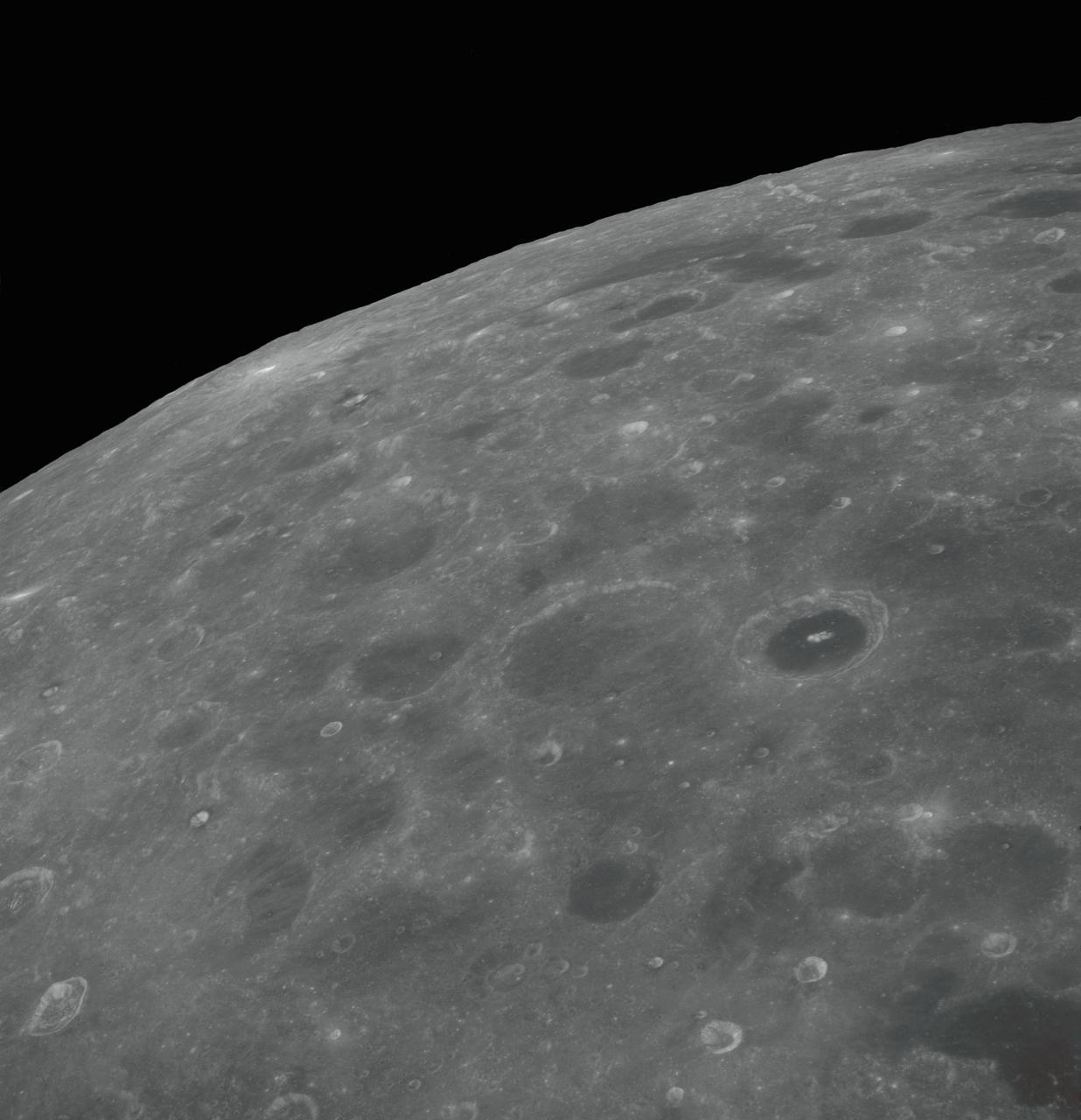
AS08-12-2192 (21-27 Dec. 1968) --- View of the lunar surface taken from the Apollo 8 spacecraft looking southward from high altitude across the Southern Sea. (Hold picture with AS8 number in upper right corner). The bright-rayed crater near the horizon is located near 130 degrees east longitude and 70 degrees south latitude. The dark-floored crater near the middle of the right side of the photograph is about 70 kilometers (45 statute miles) in diameter. Both features are beyond the eastern limb of the moon as viewed from Earth; neither has a name.
S66-54558 (14 Sept. 1966) --- Del Rio and Eagle Pass area of the Rio Grande Valley of Texas and Mexico as seen from the Gemini-11 spacecraft during its 29th revolution of Earth. Photo credit: NASA
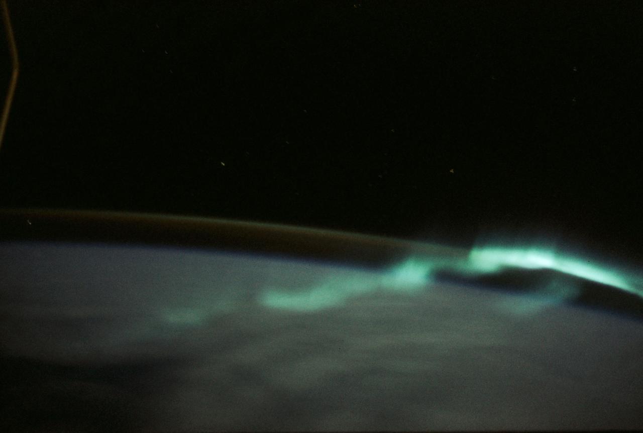
SL3-130-3130 (July-September 1973) --- An excellent view of the southern aurora, luminous bands or streamer of light, in the Southern Hemisphere, as photographed from the Skylab space station in Earth orbit. The space station was moving into the sunlight when this picture was taken. This view is near the edge of the aurora cap. The surface of the Earth is in the foreground. The permanent aurora over the South Pole is in the background. Scientist-astronaut Owen K. Garriott, Skylab 3 science pilot, took this photograph with a hand-held 35mm Nikon camera, with a four-second exposure at f/1.2, using high-speed Ektacrome film. Because auroras are caused by solar activity, they occur at the same time in the Northern and Southern hemispheres. Photo credit: NASA
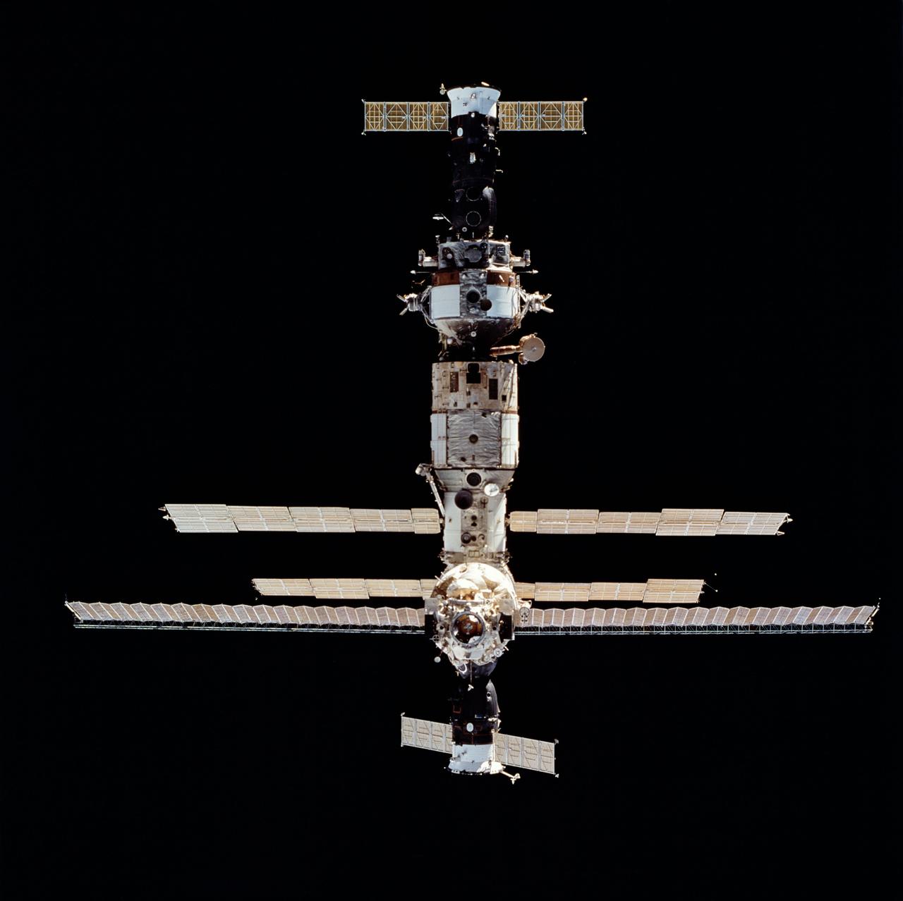
STS063-712-068 (6 Feb 1995) --- Russia's Mir Space Station during rendezvous operations with the Space Shuttle Discovery. Docked at bottom (nearest portion where longest solar array panel is visible) is a Soyuz space vehicle. On the opposite end is a Progress spacecraft. This is one of 16 still photographs released by the NASA Johnson Space Center (JSC) Public Affairs Office (PAO) on February 14, 1995. Onboard the Space Shuttle Discovery were astronauts James D. Wetherbee, mission commander; Eileen M. Collins, pilot; Bernard A. Harris, Jr., payload commander; mission specialists C. Michael Foale, Janice E. Voss, and cosmonaut Vladimir G. Titov.
AS16-118-18885 (16 April 1972) --- A good view of Earth photographed about one and one-half hours after trans-lunar injection on April 16, 1972. Although there is much cloud cover, the United States in large part, most of Mexico and some parts of Central America are clearly visible. Note Lake Michigan and Lake Superior and the Bahama Banks (see different shade of blue below Florida). Just beginning man's fifth lunar landing mission were astronauts John W. Young, commander; Thomas K. Mattingly, II, command module pilot and Charles M. Duke Jr., lunar module pilot. While astronauts Young and Duke descended in the Lunar Module (LM) "Orion" to explore the Descartes highlands region of the moon, astronaut Mattingly remained with the Command and Service Modules (CSM) "Casper" in lunar orbit.
AS07-04-1590 (20 Oct. 1968) --- Tuamotu Archipelago in the South Pacific Ocean, looking southwest, as photographed from the Apollo 7 spacecraft during its 141st revolution of Earth. The photograph was taken from an altitude of 110 nautical miles, at a ground elapsed time of 224 hours and 18 minutes.
AS08-12-2193 (21-27 Dec. 1968) --- View of the lunar surface taken from the Apollo 8 spacecraft looking southward from high altitude across the Southern Sea. (Hold picture with AS8 number in upper right corner). The bright-rayed crater near the horizon is located near 130 degrees east longitude and 70 degrees south latitude. The dark-floored crater near the middle of the right side of the photograph is about 70 kilometers (45 statute miles) in diameter. Both features are beyond the eastern limb of the moon as viewed from Earth; neither has a name.
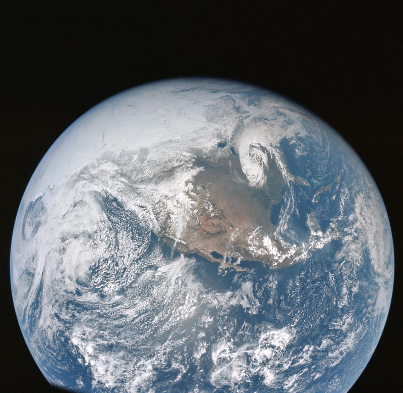
AS16-118-18880 (16 April 1972) --- A good view of Earth photographed about one hour after trans-lunar injection on April 16, 1972. Although there is much cloud cover, the United States in large part, most of Mexico and some of Central America are clearly visible. Note the Great Lakes (Michigan and Superior) and the Bahama Banks (note different shade of blue below Florida). While astronauts John W. Young, commander, and Charles M. Duke Jr., lunar module pilot, descended in the Lunar Module (LM) "Orion" to explore the Descartes highlands region of the moon, astronaut Thomas K. (Ken) Mattingly II, command module pilot, remained with the Command and Service Modules (CSM) "Casper" in lunar orbit.
S66-62984 (13 Nov. 1966) --- Astronaut Edwin Aldrin Jr. photographed inside the Gemini-12 spacecraft cabin during the spaceflight. Photo credit: NASA
AS08-12-2209 (21-27 Dec. 1968) --- High altitude oblique view of the lunar surface, looking northeastward, as seen from the Apollo 8 spacecraft. The crater Joliot-Curie, about 175 kilometers in diameter and centered near 94 degrees east longitude and 27 degrees north latitude, is near the center of the left side of this photograph. The bright rayed crater near the horizon is probably located near 105 degrees east longitude and 45 degrees north latitude. Long, narrow rays that have been reported in the polar region of Earth facing hemisphere may radiate from this crater.
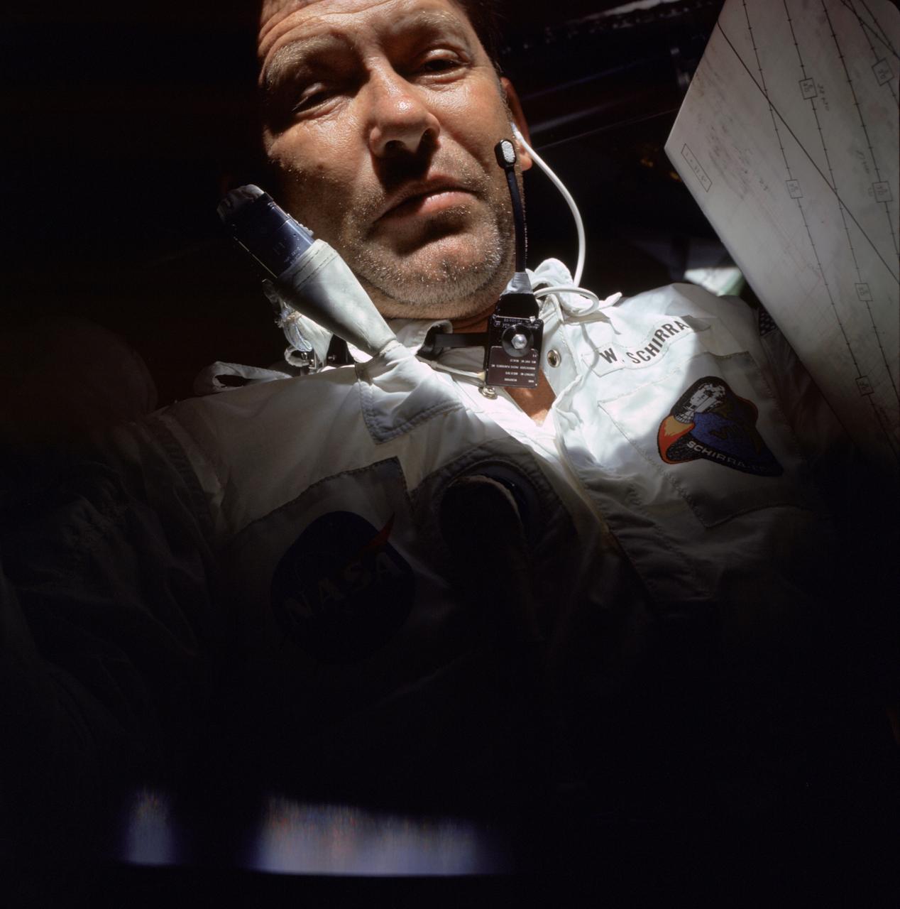
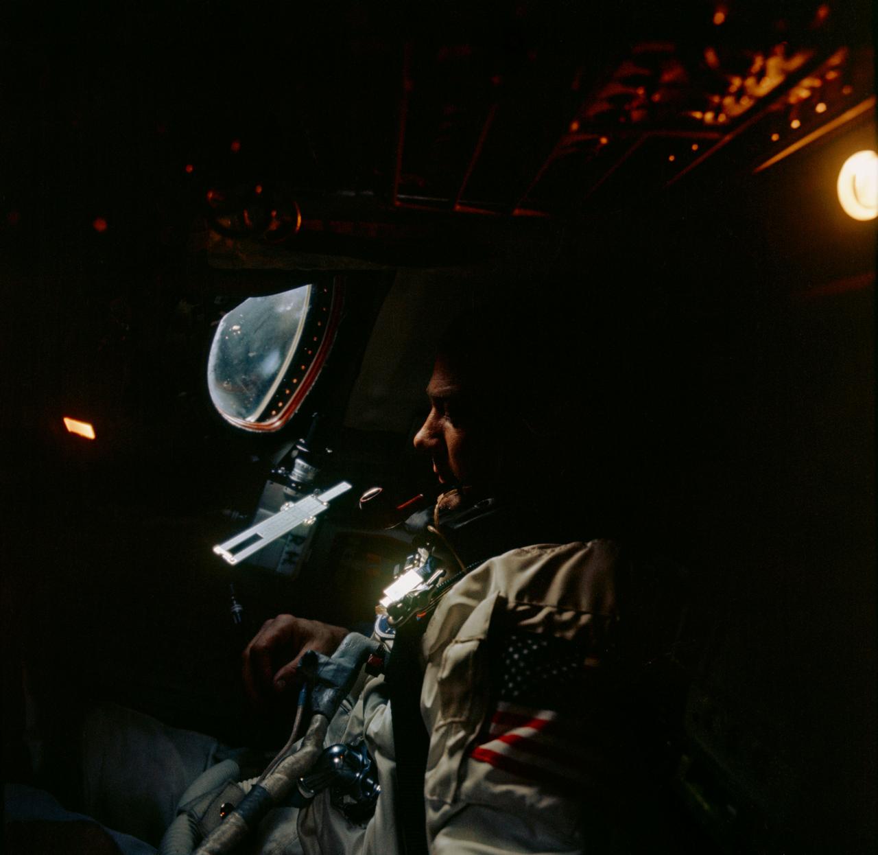
AS07-04-1582 (11-22 Oct. 1968) --- Astronaut Walter M. Schirra Jr., Apollo 7 commander, is photographed during the Apollo 7 mission.
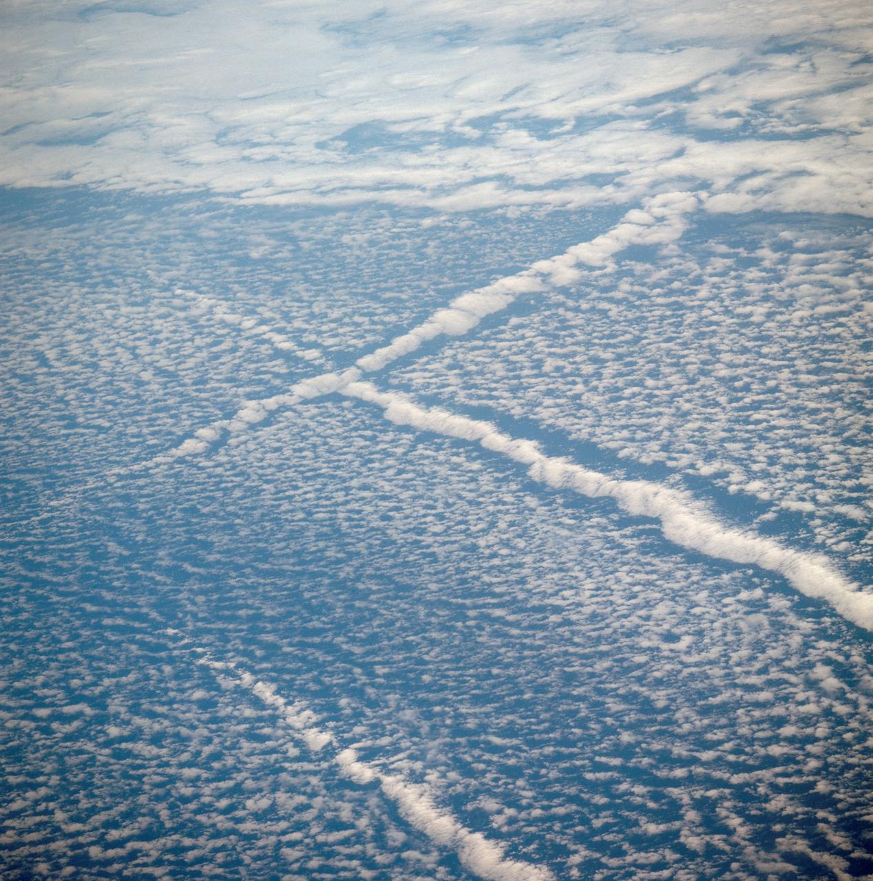
AST-01-042 (16 July 1975) --- An oblique view of unique cloud patterns over the Pacific Ocean caused by aircraft contrail shadows altering cumulus clouds and forming straight line clouds, as photographed from the Apollo spacecraft in Earth orbit during the joint U.S.-USSR Apollo-Soyuz Test Project mission. This area is southwest of Los Angeles, California. This photograph was taken at an altitude of 177 kilometers (110 statute miles) with a 70mm Hasselblad camera using medium-speed Ektachrome QX-807 type film.
AS11-36-5365 (21 July 1969) --- A close-up view of the docking target on the Apollo 11 Lunar Module (LM) photographed from the Command Module during the LM/CSM docking in lunar orbit. Astronauts Neil A. Armstrong, commander, and Edwin E. Aldrin Jr., lunar module pilot, in the LM, were returning from the lunar surface. Astronaut Michael Collins, command module pilot, remained with the Command and Service Modules (CSM) in lunar orbit while Armstrong and Aldrin explored the moon.
AS10-31-4537 (18-26 May 1969) --- This near vertical photograph taken from the Apollo 10 Command and Service Modules shows features typical of the Sea of Tranquility near Apollo Landing Site 2. HOLD PICTURE WITH PRONOUNCED LINEAR FEATURE PARALLEL TO LEFT MARGIN. The proposed landing area for Apollo 11 (Lunar Landing Site 2) is a relatively smooth maria area in the upper right quadrant of the photographed area. Apollo 10 traveled from the bottom to the top of the picture. The prominent linear feature at left is Hypatia Rille (called "U.S. 1" by the Apollo 10 crew). The prominent crater centered in Hypatia Rille at top left is Moltke AC (code name "Chuck Hole"). Moltke, the prominent crater to the right of Hypatia Rille, is centered near 24.2 degrees east longitude, and 0.6 degrees south latitude.
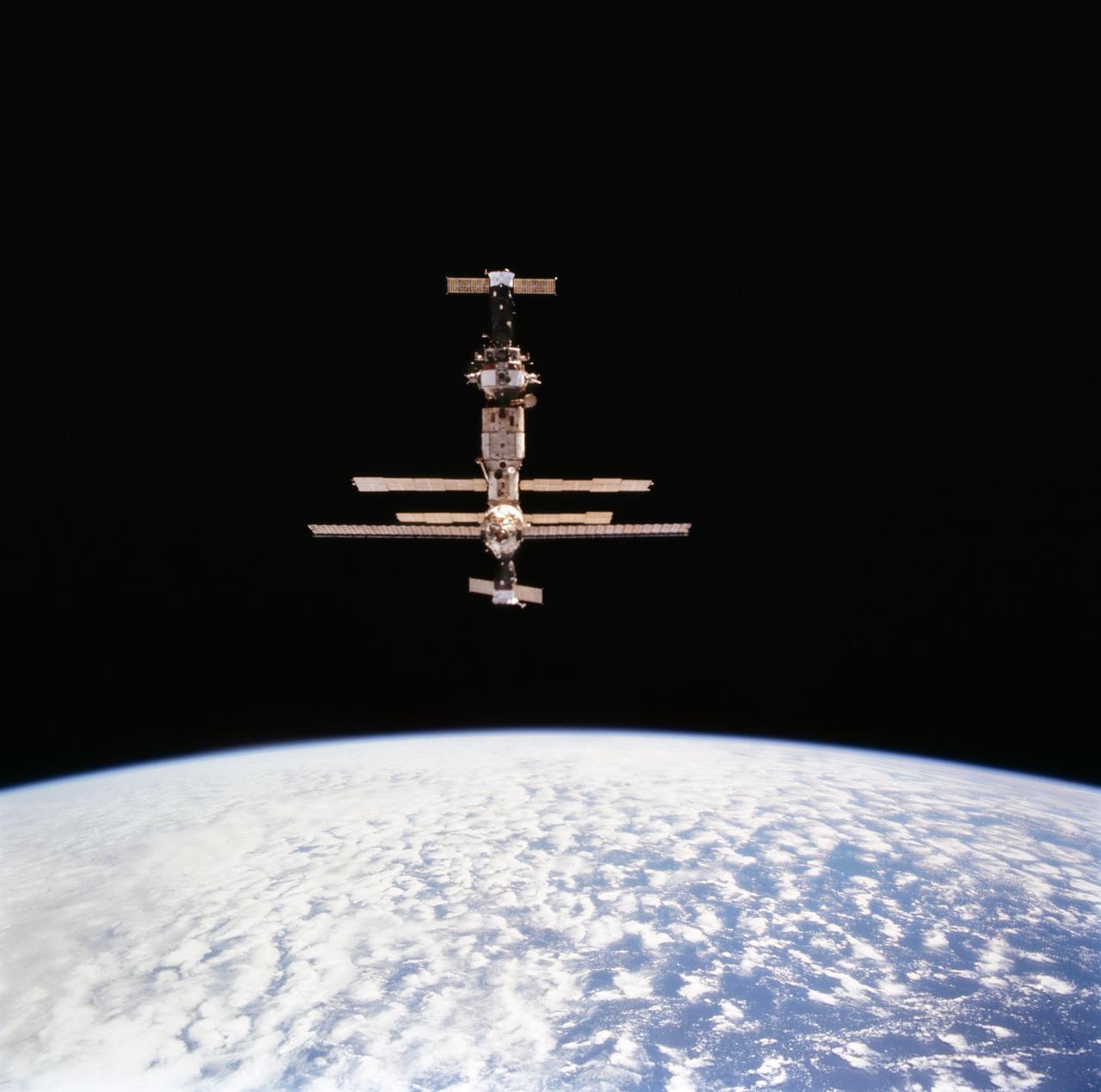
STS063-712-072 (6 Feb 1995) --- Russia's Mir Space Station over the blue and white Earth during initial approach for rendezvous operations with the Space Shuttle Discovery. Docked at bottom (nearest portion where longest solar array panel is visible) is a Soyuz space vehicle. On the opposite end is a Progress spacecraft. This is one of 16 still photographs released by the NASA Johnson Space Center (JSC) Public Affairs Office (PAO) on February 14, 1995. Onboard the Space Shuttle Discovery were astronauts James D. Wetherbee, mission commander; Eileen M. Collins, pilot; Bernard A. Harris Jr., payload commander; mission specialists C. Michael Foale, Janice E. Voss, and cosmonaut Vladimir G. Titov.
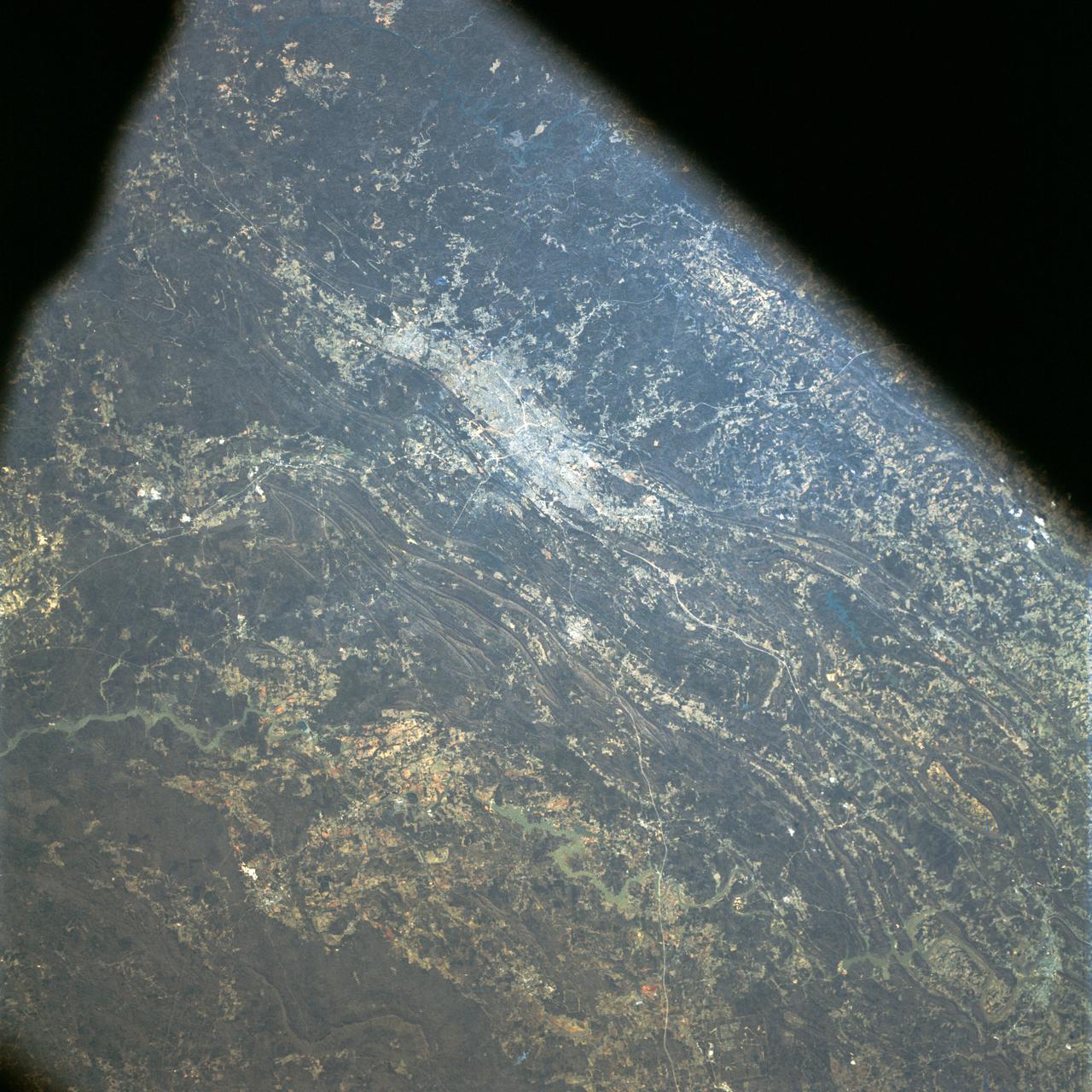
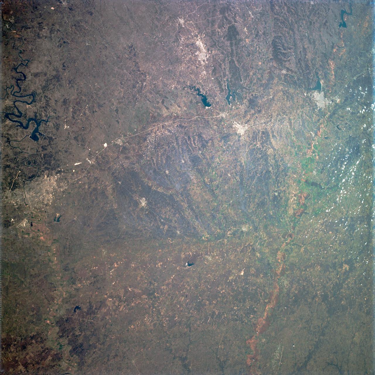
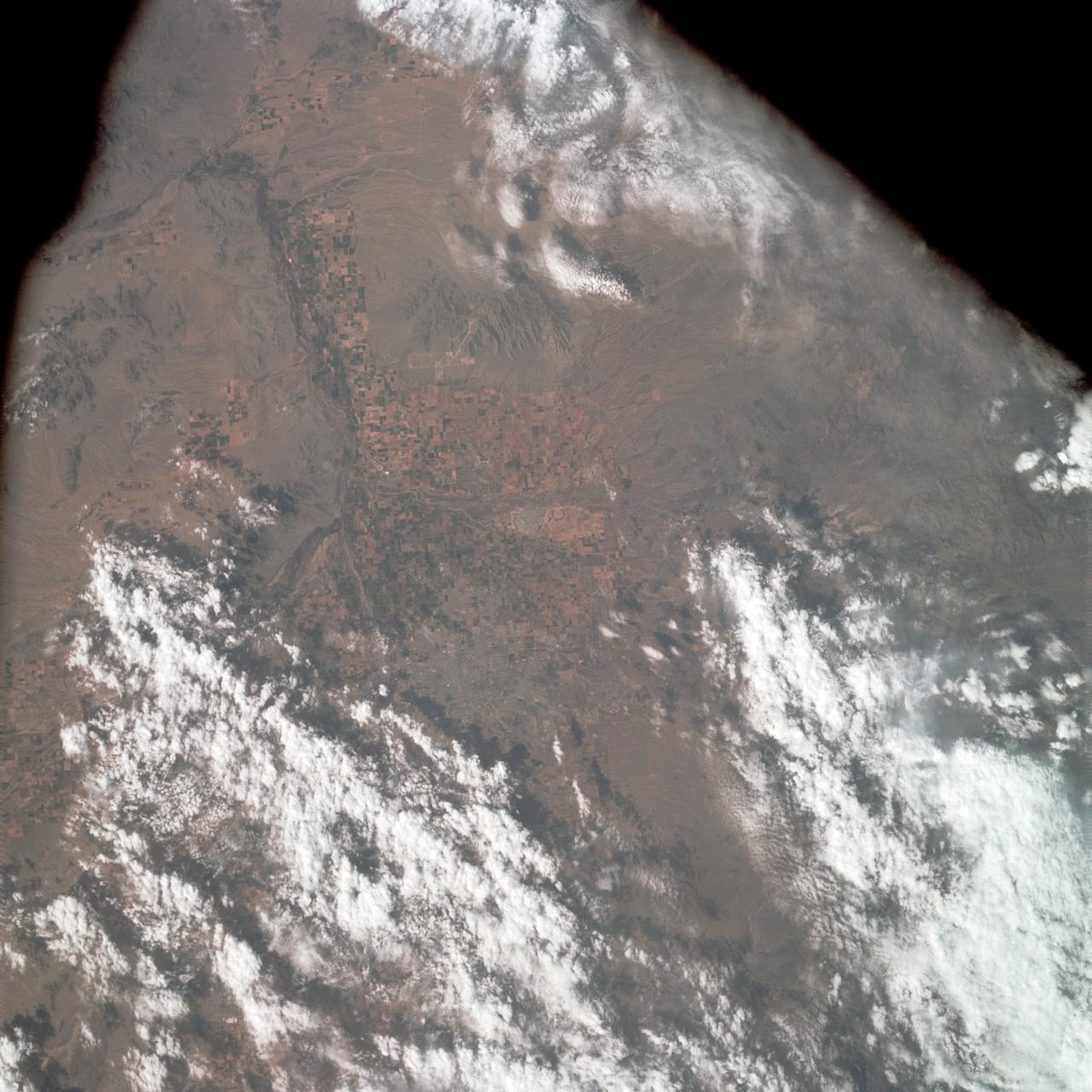
AS09-23-3566 (3-13 March 1969) --- Near vertical view of the Birmingham, Alabama area extending to Gadeden, as photographed from the Apollo 9 spacecraft during its Earth-orbital mission. The city spreads out between ridges of the folded southern Appalachian Mountains. The major stream in the picture is the Coosa River.

The greater New Orleans area, including portions of Louisiana and Mississippi, as seen from the Apollo 7 spacecraft during its 120th revolution of the earth. Photographed from an altitude of 95 nautical miles, at ground elapsed time of 190 hours and 45 minutes. The largest body of water in the picture is Lake Pontchartrain. The Mississippi River is clearly visible as it meanders past New Orleans. Note highway network, and 25-mile causeway across lake.

AS17-148-22727 (7 Dec. 1972) --- This view of Earth was seen by the Apollo 17 crew as they traveled toward the moon on their NASA lunar landing mission. This outstanding trans-lunar coast photograph extends from the Mediterranean Sea area to the Antarctica south polar ice cap. This is the first time the Apollo trajectory made it possible to photograph the south polar ice cap. Note the heavy cloud cover in the Southern Hemisphere. Almost the entire coastline of Africa is clearly visible. The Arabian Peninsula can be seen at the northeastern edge of Africa. The large island off the coast of Africa is the Malagasy Republic. The Asian mainland is on the horizon toward the northeast. The Apollo 17 crew consisted of astronauts Eugene A. Cernan, mission commander; Ronald E. Evans, command module pilot; and Harrison H. Schmitt, lunar module pilot. While astronauts Cernan and Schmitt descended in the Lunar Module (LM) to explore the moon, astronaut Evans remained with the Command and Service Modules (CSM) in lunar orbit.
AS10-27-3908 (18-26 May 1969) --- An Apollo 10 photograph of the lunar nearside looking westward across Apollo Landing Site 3 in Central Bay. Bruce, the prominent crater in the lower right corner, is about 3.7 statute miles in diameter. Topographic features on the surface of Central Bay are accentuated by the low sun angle.
S66-46270 (18 July 1966) --- Astronaut Michael Collins is photographed inside the spacecraft during the Gemini-10 mission. Photo credit: NASA
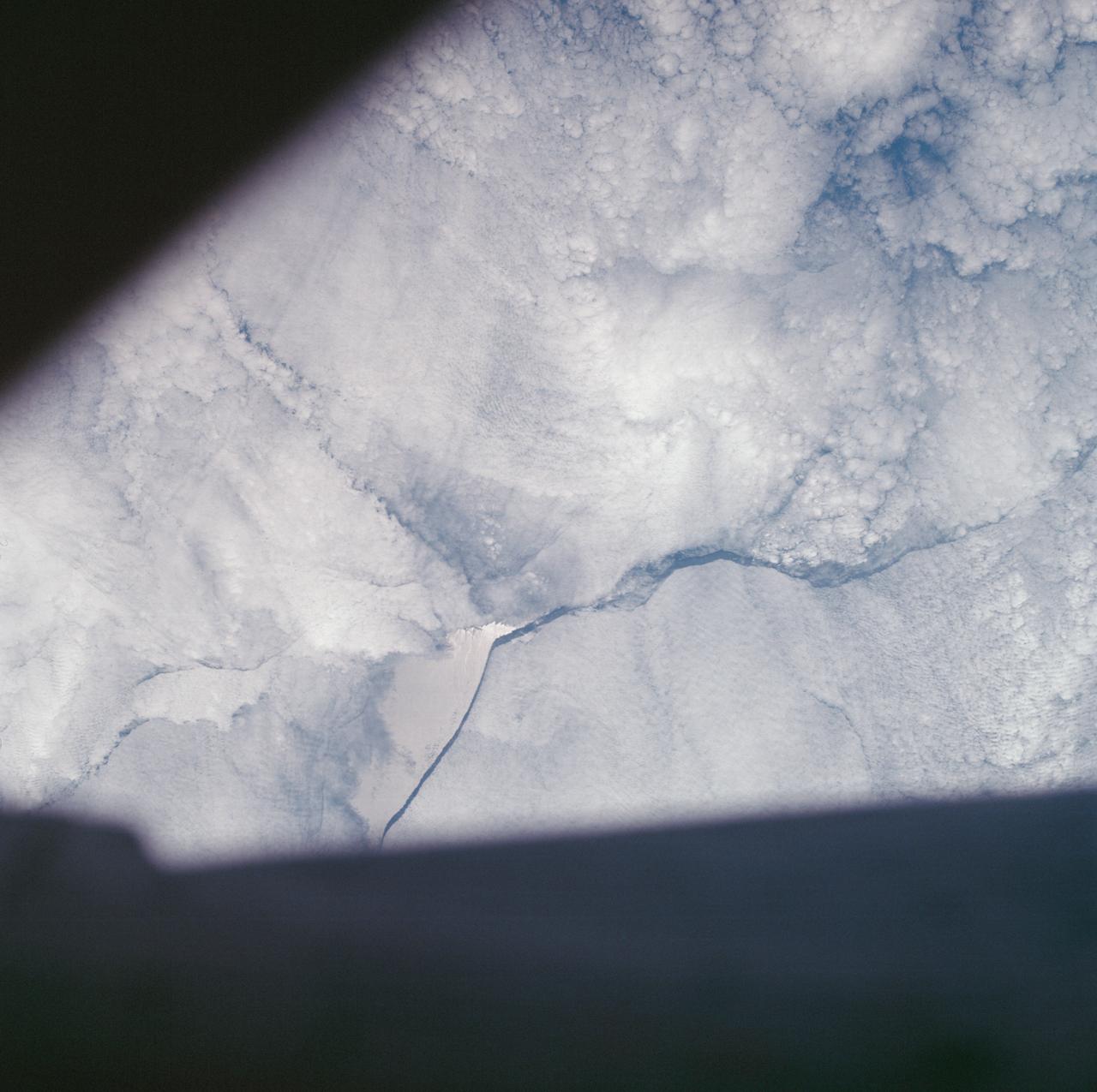
SL4-142-4577 (28 Jan. 1974) --- Two large ice islands in the vicinity of South Georgia Island in the South Atlantic Ocean, as photographed from the Skylab space station in Earth orbit by one of the Skylab 4 crewmen. The camera used was a hand-held 70mm Hasselblad, with SO-368 medium-speed Ektachrome. One of the ice islands is partially obscured by clouds. Ice islands were observed as large as 45 by 60 kilometers (27 x 37 miles) and as far north as 45 degrees south latitude. The size and distribution of the "small" icebergs (to a ship they would look very large) can be used to study the local winds and currents. Recent research has suggested the possibility of towing such Antarctic icebergs to selected areas and using them as water supplies. One such iceberg would contain many times the water as in Lake Powell. Photo credit: NASA
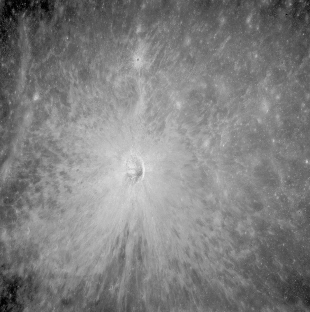
AS08-12-2148 (21-27 Dec. 1968) --- View of the lunar surface as photographed from the Apollo 8 spacecraft. Zero-phase bright spot. With near-vertical sun illumination, topographical detail is washed out and differences in surface brightness are accentuated. The numerous small bright-halo craters become conspicuous. A few larger craters have extremely bright inner walls that are commonly streaked by darker material. The bright glow near the conspicuous bright-walled crater is a halo that surrounds the position of the spacecraft shadow.
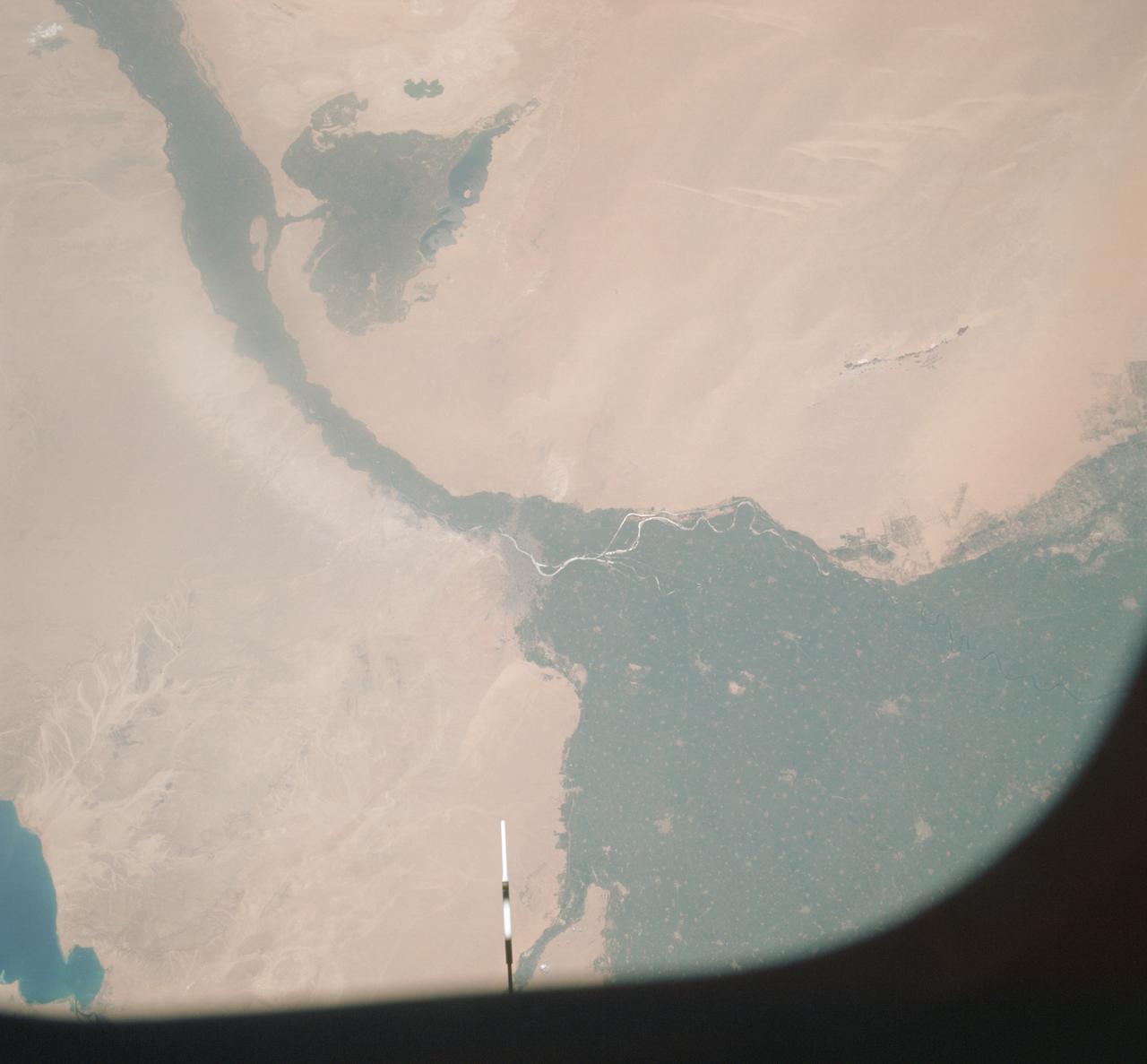
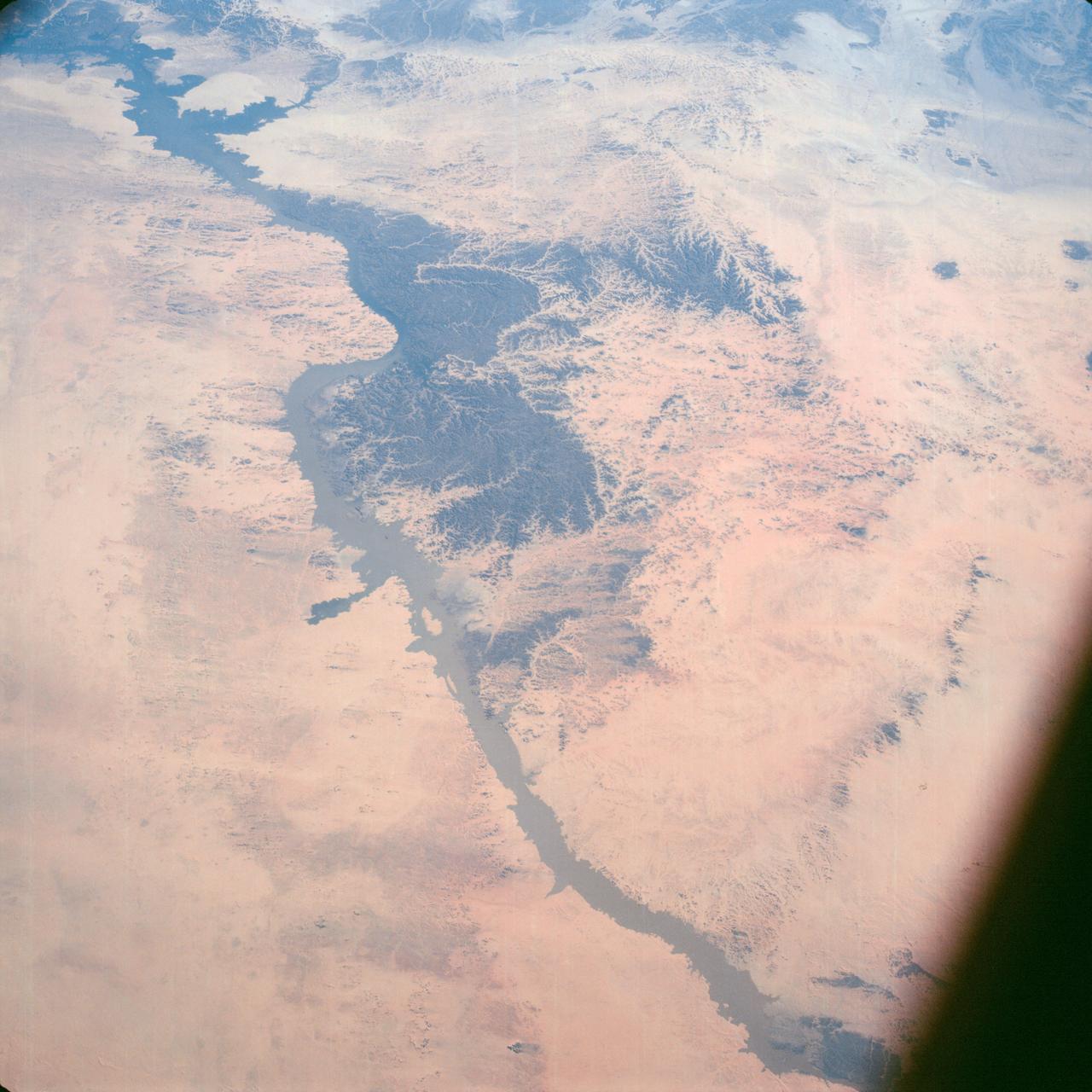
AST-09-555 (19 July 1975) --- A vertical view of a portion of the Arab Republic of Egypt, as photographed from the Apollo spacecraft in Earth orbit during the joint U.S.-USSR Apollo-Soyuz Test Project mission. The Nile Delta is in the most northerly corner of the picture. The City of Cairo on the Nile River is in the center of the photograph. The Gulf of Suez is in the most easterly corner of the picture. El Faiyum is south-southwest of Cairo. This picture was taken at an altitude of 223 kilometers (138 statute miles), with a 70mm Hasselblad camera using medium-speed Ektachrome QX-807 type film.
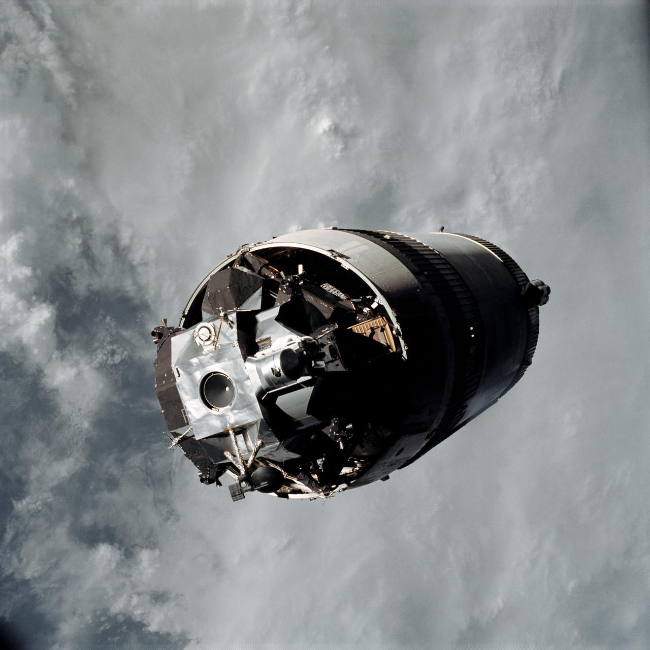
AS09-19-2919 (3 March 1969) --- The Lunar Module (LM) "Spider", still attached to the Saturn V third (S-IVB) stage, is photographed from the Command and Service Modules (CSM) "Gumdrop" on the first day of the Apollo 9 Earth-orbital mission. This picture was taken following CSM/LM-S-IVB separation and prior to LM extraction from the S-IVB. The Spacecraft Lunar Module Adapter (SLA) panels have already been jettisoned. Inside the Command Module were astronauts James A. McDivitt, commander; David R. Scott, command module pilot; and Russell L. Schweickart, lunar module pilot.
S65-63797 (12 Dec. 1965) --- Polaris, underwater launch, missile and trail, off Florida, as seen from the Gemini-7 spacecraft during its 31st revolution of Earth. Photo credit: NASA

AS11-37-5445 (20 July 1969) --- The Apollo 11 Command and Service Modules (CSM) are photographed from the Lunar Module (LM) in lunar orbit during the Apollo 11 lunar landing mission. The lunar surface below is in the north central Sea of Fertility. The coordinates of the center of the picture are 51 degrees east longitude and 1 degree north latitude. About half of the crater Taruntius G is visible in the lower left corner of the picture. Part of Taruntius H can be seen at lower right.

AS07-04-1600 (20 Oct. 1968) --- Astronaut Donn F. Eisele, Apollo 7 command module pilot, smiles through a heavy growth of beard as he is photographed during a momentary pause on the ninth day of the Apollo 7 mission.

S66-25774 (16 March 1966) --- The Agena Target Docking vehicle seen from the Gemini-8 spacecraft during rendezvous in space. The Agena is approximately 1,000 feet away from the nose of the spacecraft (lower left). Photo credit: NASA

AS09-22-3436 (March 1969) --- Los Angeles-Long Beach area of southern California, as photographed from the Apollo 9 spacecraft during its 92nd revolution of Earth. Santa Catalina Island is located off the coast. The California coastline is visible from San Clemente northward to Point Dume. Clouds cover most of the San Gabriel Mountains around Los Angeles.
AS09-22-3341 (3-13 March 1969) --- Central Texas area as photographed from the Apollo 9 spacecraft during its Earth-orbital mission. Interstate 35 runs from Austin (right center edge of picture) to Waco (near bottom left corner). Also visible are the cities of Georgetown, Taylor, Temple and Killeen. The Colorado River runs through Austin. The Brazos River flows through Waco. Lake Travis is upstream from Austin. Lake Whitney is at bottom left corner of picture. The Belton Reservoir is near bottom center. The lake formed by the dam on the Lampasas River near Belton is also clearly visible.
AS14-66-9344 (February 1971) --- The Apollo Command and Service Modules (CSM) are photographed against a black sky background from the Lunar Module (LM) above the moon. While astronauts Alan B. Shepard Jr., commander, and Edgar D. Mitchell, lunar module pilot, descended in the LM "Antares" to explore the Fra Mauro region of the moon, astronaut Stuart A. Roosa , command module pilot, remained with the CSM "Kitty Hawk" in lunar orbit.
STS005-38-943 (17 Nov. 1982) --- The Satellite Business Systems (SBS-3) satellte is deployed from its protective cradle in the cargo bay of the space shuttle Columbia. Part of Columbia's wings can be seen on both the port and starboard sides. Part of both orbital maneuvering system (OMS) pods are seen at center. The vertical stabilizer is obscured by the satellite. Photo credit: NASA
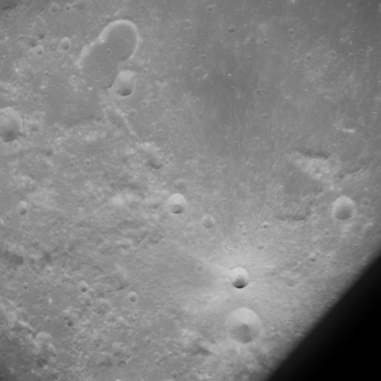
AS13-60-8675 (April 1970) --- This bright-rayed crater on the lunar farside was photographed from the Apollo 13 spacecraft during its pass around the moon. This area is northeast of Mare Marginus. The bright-rayed crater is located at about 105 degrees east longitude and 45 degrees north latitude. The crater Joliot-Curie is located between Mare Marginus and the rayed crater. This view is looking generally toward the northeast.
S66-25778 (16 March 1966) --? The Agena Target Docking Vehicle seen from the National Aeronautics and Space Administration?s Gemini-8 spacecraft during rendezvous in space. The Agena is approximately 260 feet away from the nose of the spacecraft (lower left). Crewmen for the Gemini-8 mission are astronauts Neil A. Armstrong, command pilot, and David R. Scott, pilot. Photo credit: NASA
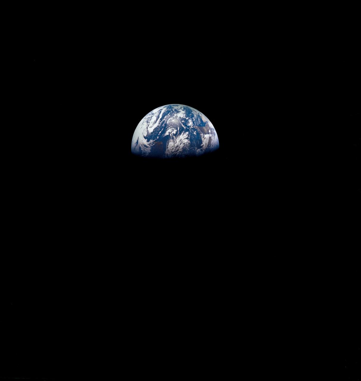
AS12-50-7362 (14 Nov. 1969) --- A view of one-third of Earth, with Australia on the horizon, as photographed by the three-man crew of Apollo 12. The Command and Service Modules, mated to the Lunar Module (yet to be removed and transpositioned for landing) were en route to the moon for man's second mission there. Onboard the spacecraft were astronauts Charles Conrad Jr., Richard F. Gordon Jr. and Alan L. Bean. Photo credit: NASA
AS08-12-2052 (21-27 Dec. 1968) --- This near-vertical photograph from the Apollo 8 spacecraft covers an area of approximately 50 x 50 statute miles within a 250-statute-miles-in-diameter crater on the lunar farside. The center of this large crater is located at about 157 degrees west longitude and 4 degrees south latitude. The large crater in the center of the picture is about 20 statute miles in diameter.
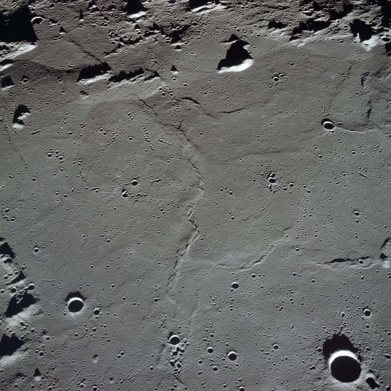
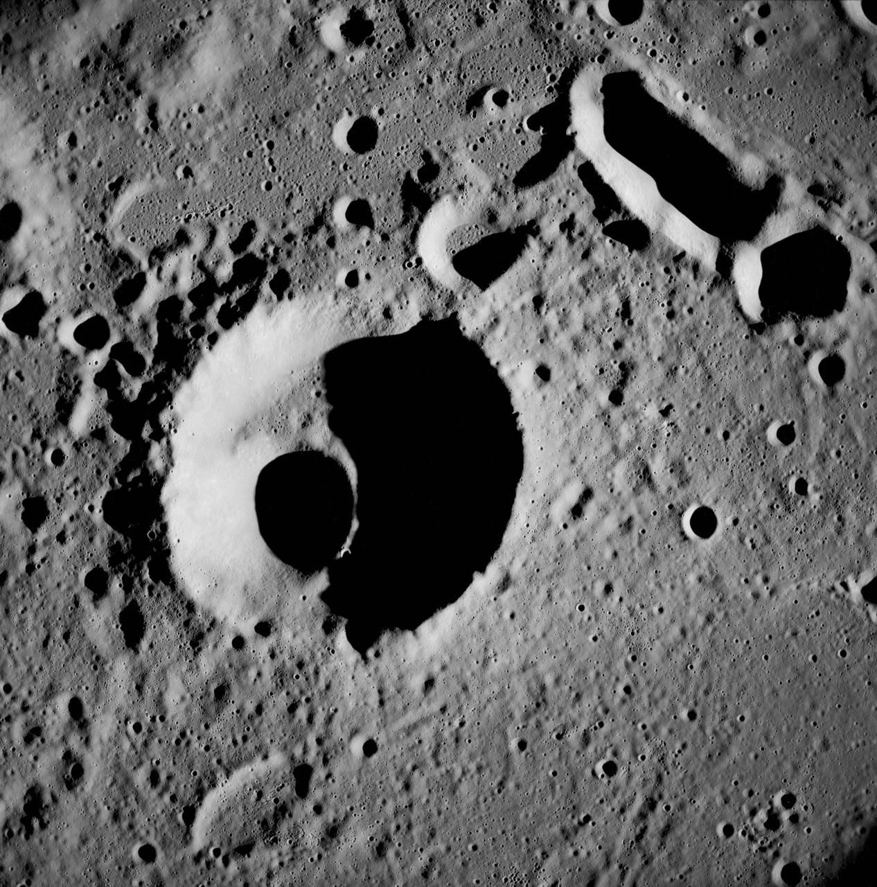
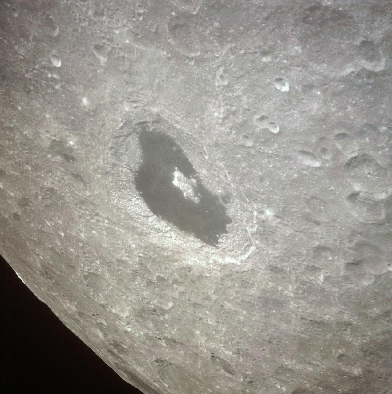
AS8-17-2704 (21-27 Dec. 1968) --- Near vertical view of the lunar farside as photographed from the Apollo 8 spacecraft. This crater, which is about 22 statute miles in diameter, is located at 167 degrees east longitude and 11 degrees south latitude. This crater is located on the eastern edge of a much larger unnamed crater which is about 90 statute miles in diameter.

SL3-111-1505 (July-September 1973) --- View of scientist-astronaut Owen K. Garriott, Skylab 3 science pilot, in his sleep restraints in the crew quarters of the Orbital Workshop (OWS). Photo credit: NASA
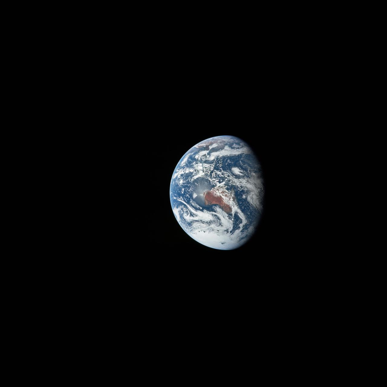
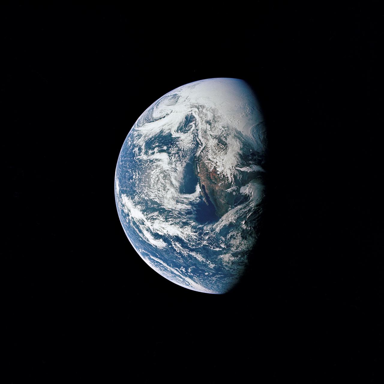
AS8-15-2561 (21-27 Dec. 1968) --- View of Earth as photographed by the Apollo 8 astronauts on their return trip from the moon. Note that the terminator is straighter than on the outbound pictures. The terminator crosses Australia. India is visible. The sun reflection is within the Indian Ocean.
AS08-13-2344 (21-27 Dec. 1968) --- This oblique photograph looks generally northwest from the Apollo 8 spacecraft into the Sea of Tranquility. (HOLD PICTURE WITH LARGE TRIANGLE FORMED BY DARK SKY AT UPPER LEFT). The three prominent craters are Taruntius F in the lower right corner; Taruntius E in the center; and Cauchy between the two linear features. The Cauchy scarp, this side of the Cauchy crater, is formed by one to three faults stepped down toward the spacecraft. Cauchy Rille, on the other side of Cauchy crater, consists of several arcuate segments of a graben. Each of the three prominent craters is 10 to 15 kilometers (6 to 9 statute miles) across.

AST-02-130 (20 July 1975) --- An oblique view of a portion of Libya and the Arab Republic of Egypt, as photographed from the Apollo spacecraft in Earth orbit during the joint U.S.-USSR Apollo-Soyuz Test Project mission. The geological features are the Jebel Uweinat and Jebel Arkenu basaltic mountains in the Libyan sand sea. This picture was taken with a 70mm Hasselblad camera using medium-speed Ektachrome QX-807 type film. The spacecraft was at an altitude of 219 kilometers (136 statute miles).
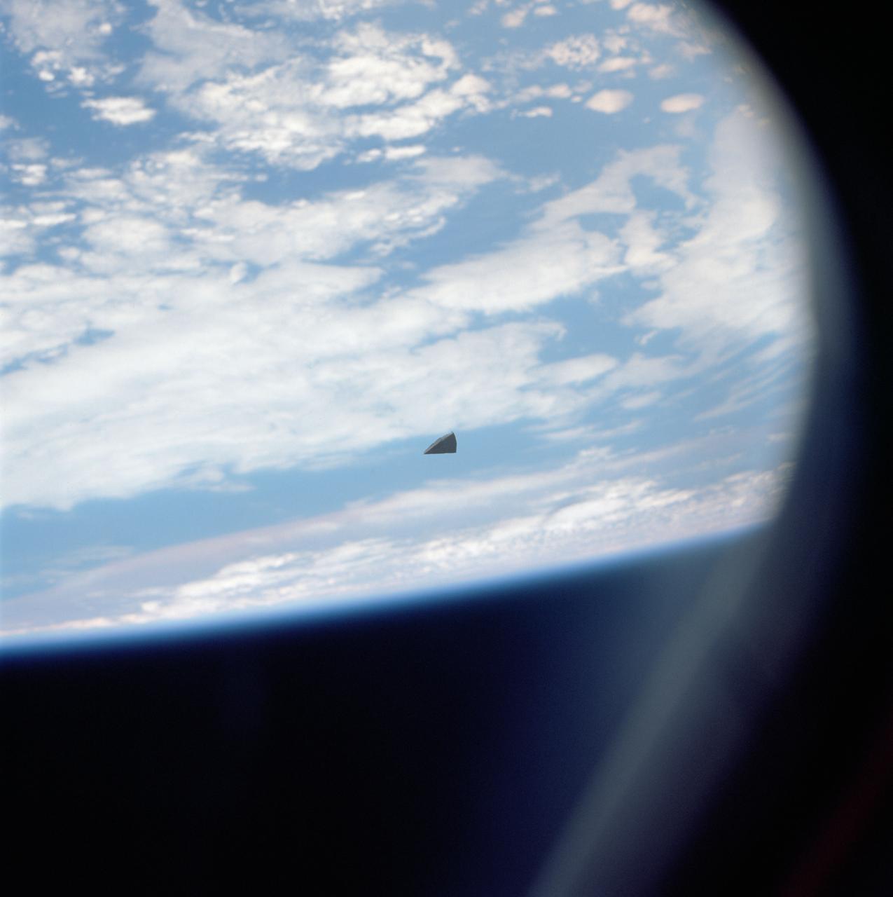
A small piece of thermal insulation tile floats in space near the Shuttle Columbia. The cloudy surface of the earth is used as a background.
AS17-148-22742 (7-19 Dec. 1972) --- Most of Australia (center) and part of Antarctica are visible in this photo of a three-quarters Earth, recorded with a 70mm handheld Hasselblad camera using a 250mm lens. The three astronauts aboard the Command and Service Modules (CSM) were in the trans-lunar coast phase of the journey when one of them snapped this shot. While astronauts Eugene A. Cernan commander, and Harrison H. Schmitt, lunar module pilot, descended in the Lunar Module (LM) "Challenger" to explore the Taurus-Littrow region of the moon, astronaut Ronald E. Evans, command module pilot, remained with the CSM "America" in lunar orbit.
SL4-140-4110 (January 1974) --- View of the USSR, Siberia area from Skylab 4. Other areas seen are Ozero, Kanka, Ussiriysk, the Sea of Japan and Kavalerovo (45.5N, 135.5E). Photo credit: NASA
AS10-34-5026 (18-26 May 1969) --- An Apollo 10 photograph of Earth taken from 100,000 miles away. Visible are many areas of Europe and Africa. Among the features and countries identifiable are Portugal, Spain, Italy, the Mediterranean Sea, Greece, Turkey, Bulgaria, the Black Sea, Libya, Egypt, Saudi Arabia, the Sinai Peninsula, the Nile Delta, Lake Chad, and South Africa. The crew members for Apollo 10 are astronauts Thomas P. Stafford, commander; John W. Young, command module pilot; and Eugene E. Cernan, lunar module pilot. Astronaut Young remained in lunar orbit, in the Command and Service Modules (CSM) "Charlie Brown", while astronauts Stafford and Cernan descended to within nine miles of the lunar surface, in the Lunar Module (LM) "Snoopy".
STS063-712-017 (6 Feb. 1995) --- Russia's Mir Space Station during rendezvous operations with the Space Shuttle Discovery. Docked at the bottom of the Mir facility is a Soyuz spacecraft. On the opposite end (almost cropped out of frame at top) is a Progress spacecraft. Onboard the Space Shuttle Discovery were astronauts James D. Wetherbee, mission commander; Eileen M. Collins, pilot; Bernard A. Harris, Jr., payload commander; C. Michael Foale and Janice E. Voss, mission specialists; along with cosmonaut Vladimir G. Titov, mission specialist.
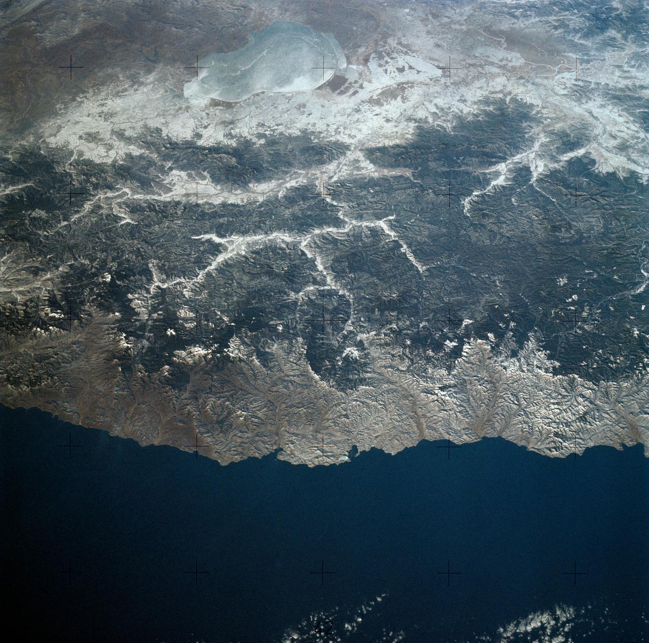
SL3-28-059 (July-September 1973) --- A vertical view of the Lake Mead and Las Vegas, Nevada area as photographed from Earth orbit by one of the six lenses of the Itek-furnished S190-A Multispectral Photographic Facility Experiment aboard the Skylab space station. Lake Mead is water of the Colorado River impounded by Hoover Dam. Most of the land in the picture is Nevada. However, a part of the northwest corner of Arizona can be seen. Federal agencies participating with NASA on the EREP project are the Departments of Agriculture, Commerce, Interior, the Environmental Protection Agency and the Corps of Engineers. All EREP photography is available to the public through the Department of Interior?s Earth Resources Observations Systems Data Center, Sioux Falls, South Dakota, 57198. Photo credit: NASA
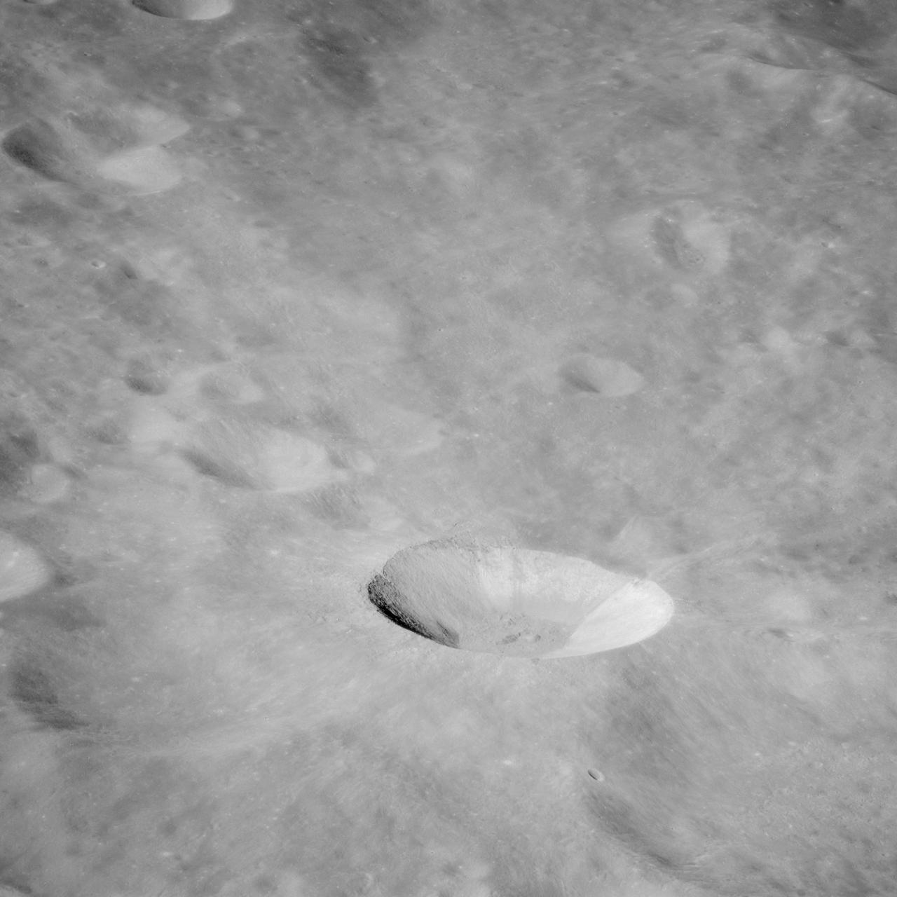
AS10-32-4845 (18-26 May 1969) --- An Apollo 10 southwest oblique view of the crater Censorinus which is located in the highland terrain bordering the Sea of Tranquility. HOLD PICUTRE WITH WINDOW FRAME AT LOWER LEFT. Censorinus is the bright crater in the lower left of the photograph. Censorinus is about 5 kilometers (about 3 statute miles) in diameter. Immediately to the left of Censorinus is the larger crater Censorinus A. The Sea of Tranquility is to the lower right of the photograph, which was taken from the Command and Service Modules. Censorinus is one of the brighter craters on the lunar surface.
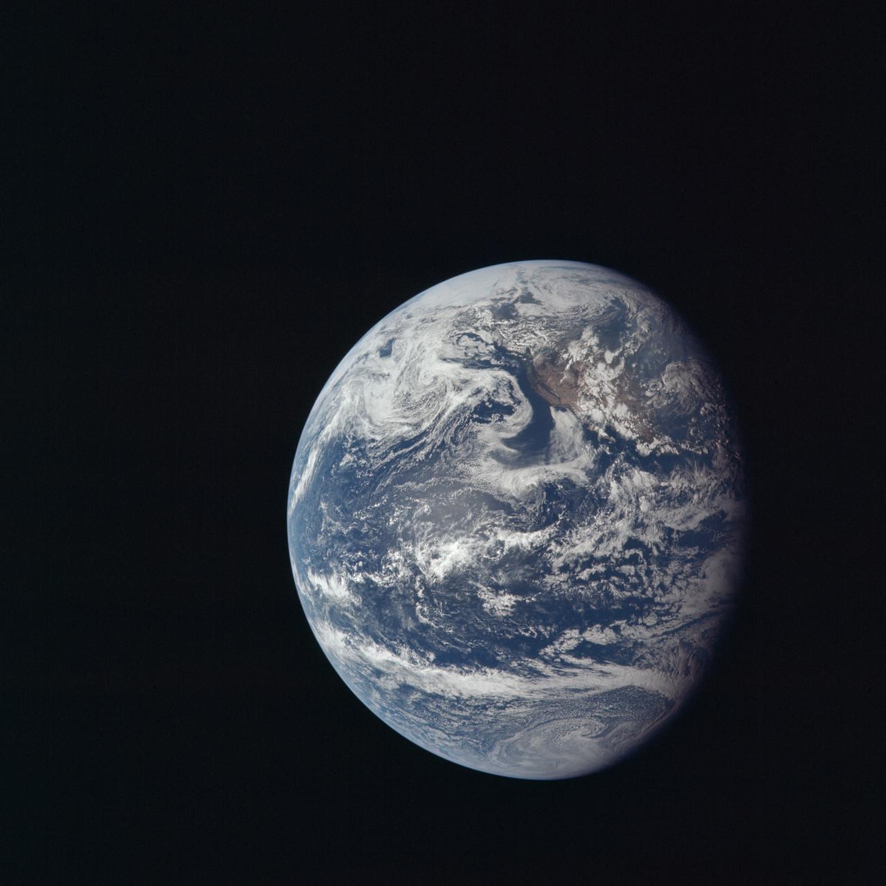
AS11-36-5337 (16 July 1969) --- This view of Earth showing clouds over its surface was photographed from the Apollo 11 spacecraft during its translunar journey toward the moon. The spacecraft was already about 10,000 nautical miles from Earth when this picture was taken. Portions of the land mass of North America and Central America can be seen. Aboard Apollo 11 were astronauts Neil A. Armstrong, Michael Collins and Edwin E. Aldrin Jr.

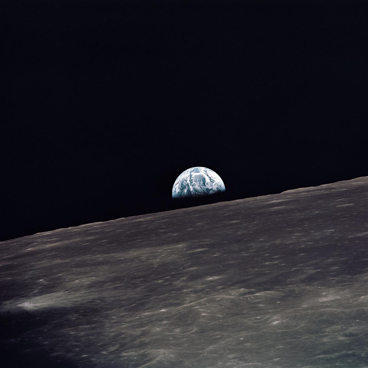
AS08-14-2383 (24 Dec. 1968) --- The rising Earth is about five degrees above the lunar horizon in this telephoto view taken from the Apollo 8 spacecraft near 110 degrees east longitude. The horizon, about 570 kilometers (350 statute miles) from the spacecraft, is near the eastern limb of the moon as viewed from Earth. Width of the view at the horizon is about 150 kilometers (95 statute miles). On Earth 240,000 statute miles away the sunset terminator crosses Africa. The crew took the photo around 10:40 a.m. Houston time on the morning of Dec. 24, and that would make it 15:40 GMT on the same day. The South Pole is in the white area near the left end of the terminator. North and South America are under the clouds.
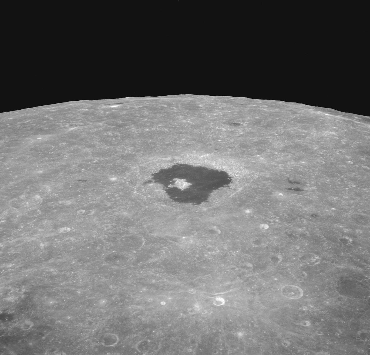
AS08-12-2196 (21-27 Dec. 1968) --- An oblique view from the Apollo 8 spacecraft looking eastward across the lunar surface from about 115 degrees east longitude to the horizon near 180 degrees east longitude. The crater Tsiolkovsky in the center of the picture is 150 kilometers wide and is located at 129 degrees east longitude and 21 degrees south latitude. While in lunar orbit, Apollo 8 moved toward the camera position over the terrain along the left (north) side of this photograph.
AS07-07-1832 (15 Oct. 1968) --- Toba, Kakar, Fort Sandeman, Sulaiman Range area in (West) Pakistan, as seen from the Apollo 7 spacecraft during its 84th revolution of Earth. Note geological features such as folded mountain structures, anticlines and synclines. Photographed from an altitude of 108 nautical miles, at ground elapsed time of 132 hours and 30 minutes.
AS07-05-1644 (13 Oct. 1968) --- Remarkable cloud patterns as seen from the Apollo 7 spacecraft during its 34th revolution of Earth. Note break in two adjacent decks of strato-cumulus cloud formations. Sea can be seen through holes in clouds.
AST-30-2601 (20 July 1975) --- An area of the Cascade Mountains southeast of Seattle in the State of Washington, as photographed from the Apollo spacecraft in Earth orbit during the joint U.S.-USSR Apollo-Soyuz Test Project mission. The view includes Snoqualmie Pass, Cle Elum Lake, Kachess Lake and Keechelus Lake. The picture was taken at an altitude of 228 kilometers (141 statute miles) with a 70mm Hasselblad camera using medium-speed Ektachrome QX-807 type film.
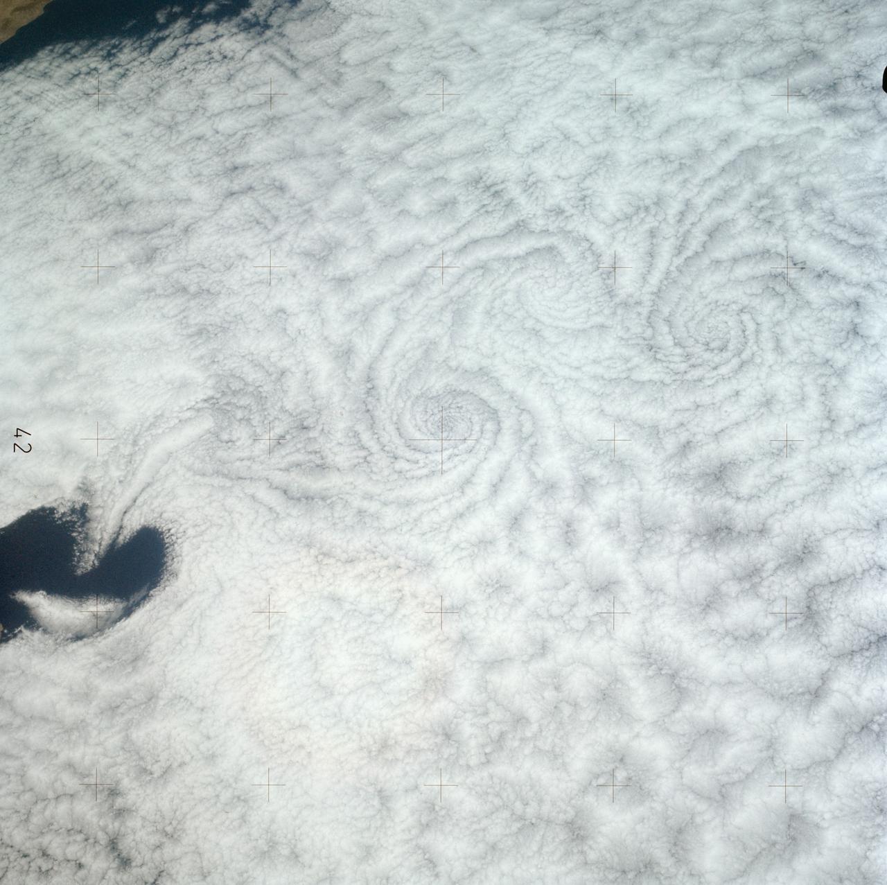
SL3-121-2371 (July-September 1973) --- A pattern of downstream eddies in the stratocumulus clouds over the Pacific Ocean west of Baja California, as photographed by the crewmen of the second Skylab manned mission (Skylab 3) from the space station cluster in Earth orbit. The clouds, produced by the cold California current running to the south and southwest, are prevented from rising by warm air above them. Photo credit: NASA
AS10-32-4819 (18-26 May 1969) --- An Apollo 10 northwestward oblique view of Triesnecker crater, centered near 3.6 degrees east longitude, and 4 degrees north latitude. HOLD PICTURE WITH SKY AT UPPER RIGHT. This picture, taken from the Command and Service Modules, shows terrain features typical of northeastern Central Bay. Beyond the highlands, the smooth floor of the Sea of Vapors extends almost to the horizon some 600 kilometers (375 statute miles) from the spacecraft. Triesnecker crater, about 27 kilometers (17 statute miles) in diameter, was 135 kilometers (85 statute miles) northwest of Apollo 10 when the picture was taken. The intersecting linear features to the right of Triesnecker crater are the Triesnecker Rilles.
AS10-27-3907 (18-26 May 1969) --- Apollo 10 westward view across Apollo Landing Site 3 in the Central Bay. Apollo Landing Site 3 is in the middle distance at the left margin of the pronounced ridge in the left half of the photograph. Bruce, the prominent crater, near the bottom of the scene, is about 6 kilometers (3.7 statute miles) in diameter. Topographic features on the surface of the Central Bay are accentuated by the low sun angle. Sun angles range from near 6 degrees at the bottom of the photograph to less than one degree at the top.
S65-63826 (5 Dec. 1965) --- Oriente Province, eastern end of Cuba, as seen from the National Aeronautics and Space Administration's Gemini-7 spacecraft during its 14th revolution of Earth. Guantanamo Bay is in the center of the picture on the southern coast of Cuba. Santiago de Cuba is located about one inch from the bottom edge of the picture, or about three inches westward down the coast from Guantanamo. This photograph was taken with a modified 70mm Hasselblad camera, using Eastman Kodak, Ektachrome MS (S.O. 217) color film. Photo credit: NASA
S65-63926 (16 Dec. 1965) --- Island of Hispaniola, Dominican Republic end, as seen from the National Aeronautics and Space Administration's Gemini-7 spacecraft during its 179th revolution of Earth. North is toward the left of the picture. This photograph was taken with a modified 70mm Hasselblad camera, using Eastman Kodak, Ektachrome MS (S.O. 217) color film. Photo credit: NASA
AS8-17-2744 (21-27 Dec. 1968) --- Oblique view of the lunar surface taken from the Apollo 8 spacecraft looking westward showing typical lunar farside terrain. (HOLD PICTURE SO THAT DARK IRREGULAR AREA SURROUNDED BY LIGHT SPOTS IS IN THE LOWER RIGHT QUARTER). The sharp crater near the center of then scene is near 117 degrees east longitude and 5 degrees south latitude; and it is 25 kilometers (15 statute miles) in diameter. That crater is on the rim of a large crater that occupies the lower right quarter of the photograph.

S66-46025 (18 July 1966) --- Astronaut Michael Collins, Gemini-10 pilot, photographed this MSC-8 color patch outside the spacecraft during the Gemini-10/Agena docking mission. The experiment was for the purpose of showing what effect the environment of space will have upon the color photography taken in cislunar space and on the lunar surface during an Apollo mission. Photo credit: NASA
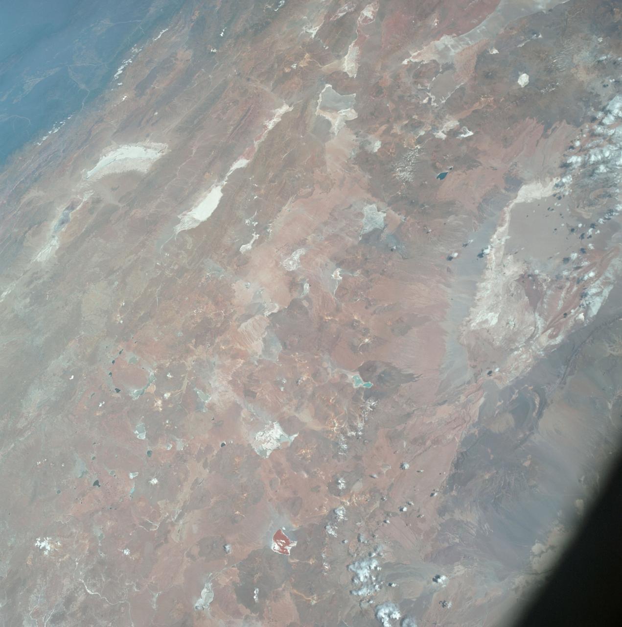
AS07-04-1593 (21 Oct. 1968) --- This Earth observation photograph shows Argentina, Chile, Bolivia, Salar de Atacama, the Andes Mountains, and Gran Chaco. The coordinates for the center of this photograph are 23.00 degrees south and 67.30 degrees west, taken at an altitude of 175 miles during the 154th revolution around Earth. The crew consisted of astronauts Walter M. Schirra, Donn F. Eisele and Walter Cunningham.
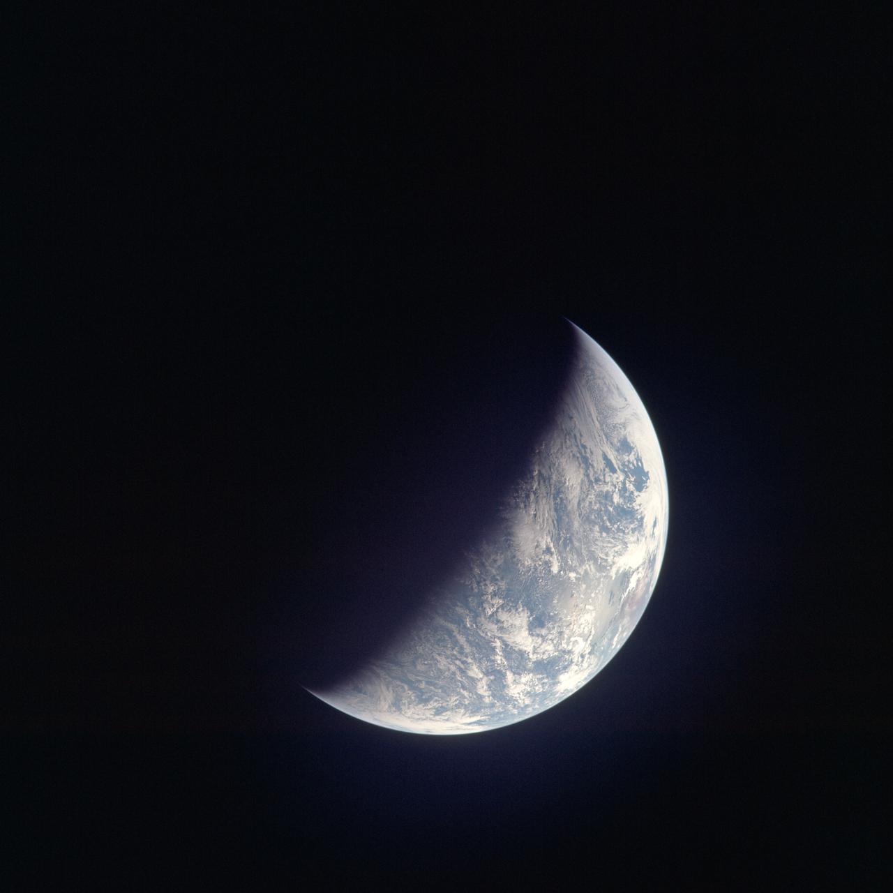
AS13-60-8588 (17 April 1970) --- This photograph of Earth was taken from the National Aeronautics and Space Administration's (NASA) Apollo 13 spacecraft during its trans-Earth journey home. The most visible land mass includes southwestern United States and northwestern Mexico. The peninsula of Baja California is clearly seen. Most of the land area is under heavy cloud cover. The Apollo 13 crew consisted of astronauts James A. Lovell Jr., commander; John L. Swigert Jr., command module pilot; and Fred W. Haise Jr., lunar module pilot.
AS09-22-3441 (March 1969) --- Near vertical view of the Phoenix, Arizona area as photographed from the Apollo 9 spacecraft during its Earth-orbital mission. Farmland patterns checkerboard the area along the Gila River. Phoenix is located right of center near the clouds.
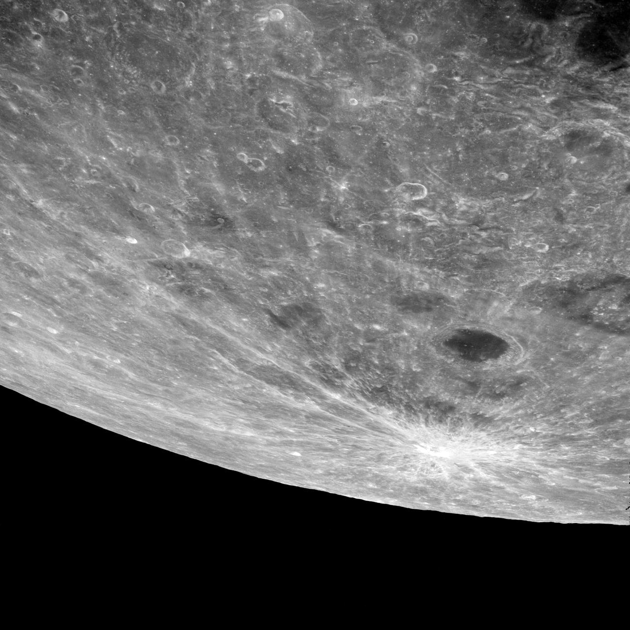
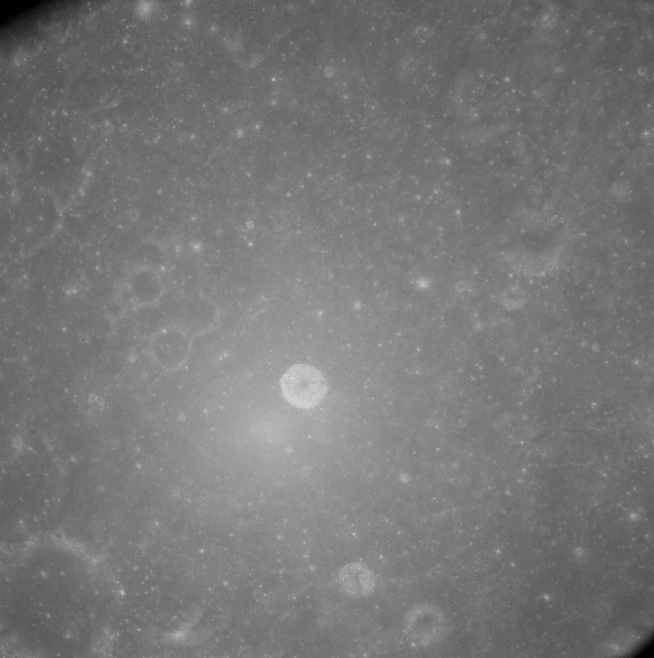
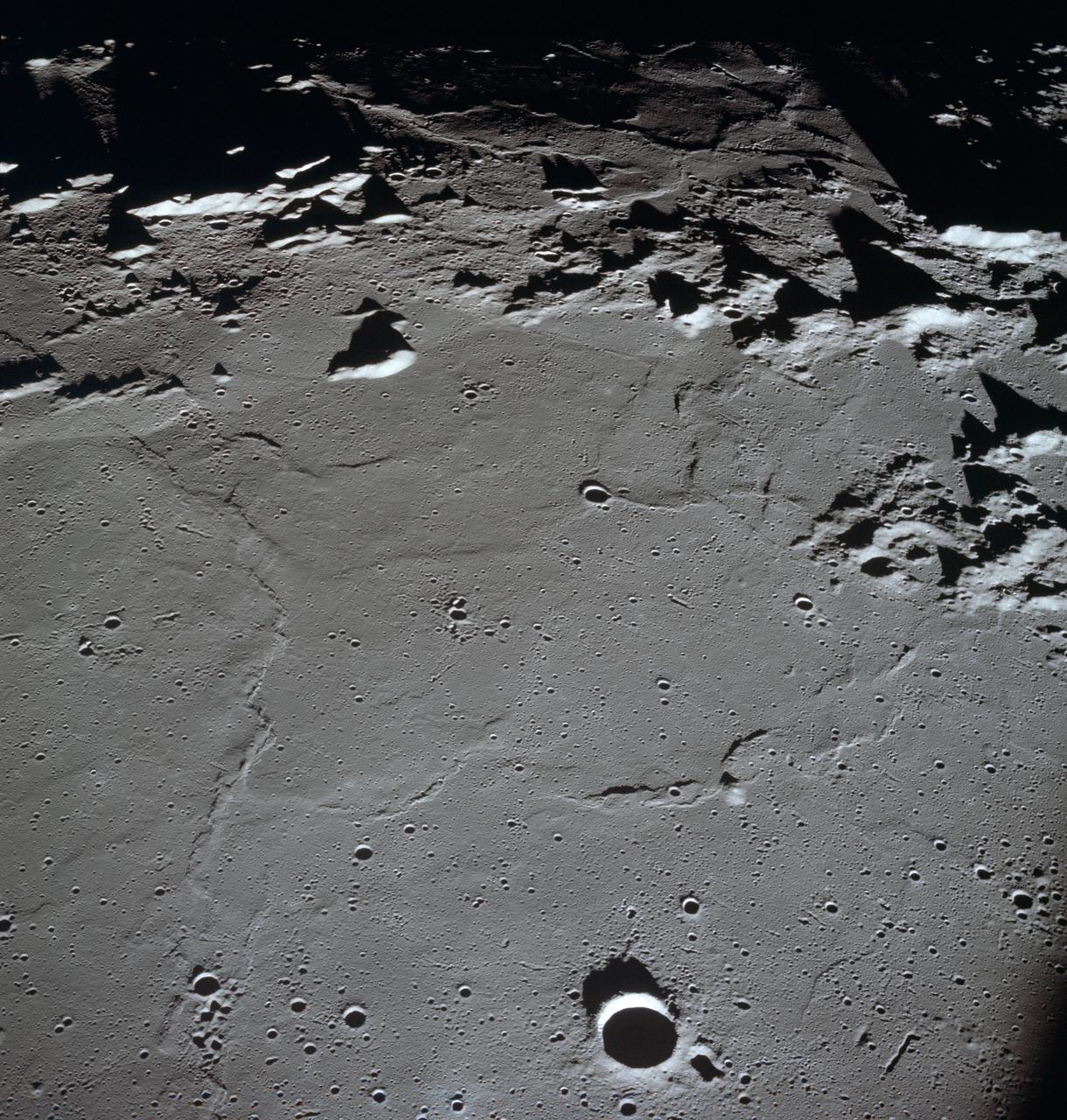
AS13-60-8659 (14 April 1970) --- Excellent view of the lunar farside showing the crater Tsiolkovsky, as photographed by the crew of the Apollo 13 mission during their lunar pass. The view is looking southeast toward the lunar horizon. The approximate coordinates of Tsiolkovsky are 128.5 degrees east longitude and 20.5 degrees south latitude. The Apollo 13 crew members were forced to cancel their scheduled lunar landing because of an apparent explosion of oxygen tank number two in the Service Module (SM).

AS09-20-3128 (3-13 March 1969) --- Cape Hatteras, North Carolina, area as photographed from the Apollo 9 spacecraft during its Earth-orbital mission. Cape Lookout is near bottom of picture. Cape Hatteras juts the farthest out into the Atlantic. Largest inland body of water is Pamlico Sound; and to the north of it is Albemarle Sound.
AS10-34-5013 (18 May 1969) --- A view of Earth from 36,000 nautical miles away as photographed from the Apollo 10 spacecraft during its trans-lunar journey toward the moon. While the Yucatan Peninsula is obscured by clouds, nearly all of Mexico north of the Isthmus of Tehuantepec can be clearly delineated. The Gulf of California and Baja California and the San Joaquin Valley can be easily identified. Also, the delta of the Rio Grande River and the Texas coast are visible. Note the color differences (greens - east, browns - west) along the 100 degrees meridian. The crew members on Apollo 10 are astronauts Thomas P. Stafford, commander; John W. Young, command module pilot; and Eugene E. Cernan, lunar module pilot. Astronaut Young remained in lunar orbit, in the Command and Service Modules (CSM) "Charlie Brown", while astronauts Stafford and Cernan descended to within nine miles of the lunar surface, in the Lunar Module (LM) "Snoopy".
AS10-31-4650 (18-26 May 1969) --- This Apollo 10 oblique telephoto view of the lunar nearside is centered on the crater Hyginus located at 6.3 degrees north latitude, near the northeast margin of Central Bay. HOLD PICTURE WITH SKY AT TOP. The crater is about 10 kilometers (6.5 statue miles) in diameter. From the crater the prominent Hyginus Rille extends east-southeast toward the camera and northwest toward the Sea of Vapors. The rille is about 3 kilometers (2 statue miles) wide and more than 200 kilometers (130 statue miles) long. The horizon is not visible in this photograph, taken from the Command and Service Modules. The sunrise terminator is between the spacecraft and the horizon. At the time this picture was taken Apollo 10 was 325 kilometers (200 statute miles) southeast of Hyginus.
S66-25784 (16 March 1966) --? The Agena Target Docking Vehicle seen from the National Aeronautics and Space Administration?s Gemini adapter of the Agena is approximately two feet from the nose of the spacecraft (lower left). Crewmen for the Gemini-8 mission were astronauts Neil A. Armstrong, command pilot, and David R. Scott, pilot. Photo credit: NASA
AS7-05-1667 (13 Oct. 1968) --- Kabul, Afghanistan area as seen from the Apollo 7 spacecraft during its 39th revolution of Earth. Photographed from an altitude of 127 nautical miles, at ground elapsed time of 61 hours and 20 minutes. Also, visible in picture are the Panjshir River and the Koh-i-Baba Mountains.
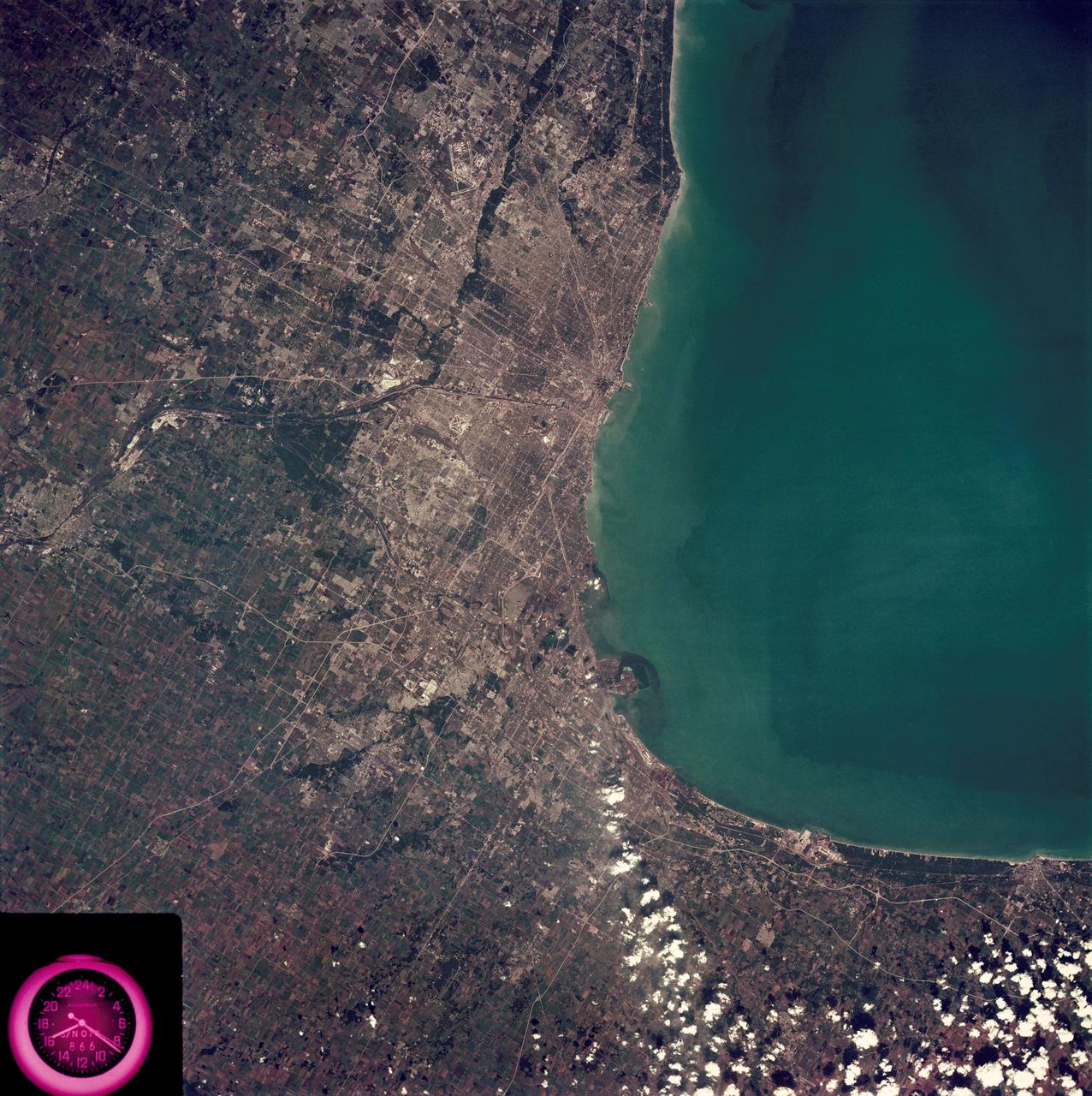
SL3-88-222 (18 Sept. 1973) --- The metropolitan area of Chicago is encompassed in this Skylab 3 Earth Resources Experiments Package (EREP) S190-B photograph taken on Sept. 18, 1973 from the Skylab space station cluster in Earth orbit. The surrounding major cities of Aurora and Joliet, Illinois; Hammond, Gary and East Chicago, Indiana, are easily delineated. The photograph reveals the following: (1) Cultural differentiation of commercial, industrial and residential areas for use in population and social studies in micro-macro community planning and in cultural pattern studies in the improvement of urban areas. (Aurora is one of 27 census cities of interest to Robert Alexander, a principal investigator. Alexander is with the U.S. Geological Survey). (2) The transportation network with major corridors and their interchanges, primary and feeder streets for use in network analysis and in the development of models for population movement and land use projection. (3) The agricultural lands for land use identification on crop inventory analysis; airports for use in delineation of service and infringement of major man-made features that affect ecosystem balance (support to environmental impact studies). (4) Air and water plumes for use in case studies, natural and man-made differentiation of pollution sources, in support of model development and in ecosystem research studies on the effects of pollution. (5) Recreational centers for use in relating recreational centers to population centers, establishing possible demands and in development of possible future recreational centers to support the demand. All EREP photography is available to the public through the Department of Interior?s Earth Resources Observations Systems Data Center, Sioux Falls, South Dakota, 57198. Photo credit: NASA
AS10-34-5173 (18-26 May 1969) --- An Apollo 10 photograph of the lunar farside showing an area in the vicinity of International Astronomical Union (I.A.U.) crater No. 300, taken from the Command and Service Modules. This view is looking south over typical rugged lunar terrain. I.A.U. crater No. 300 is located at 155 degrees east longitude and 10 degrees south latitude.
This view of southern California as seen from the Apollo 7 spacecraft during its 18th revolution of the earth. Photographed from an altitude of 124 nautical miles. The coast of California can be seen from Point Mugu southward to Oceanside. Santa Catalina can be seen below the off shore clouds. Details of the Los Angeles area are obscured by pollution which extends from Banning westard for 100 miles to beyond Malibu. In the upper portion of the photograph can be seen (left to right) the San Joaquin Valley beyond Bakersfield, the Techachapi Mountains, the Sierra Nevada, Owens Valley, Death Valley and the Mojave Desert.
Lake Nasser on the Nile River in southeastern United Arab Republic (Egypt) as seen from the Apollo 7 spacecraft during its 10th revolution of the earth. Photographed from an altitude of 130 nautical miles, at ground elapsed time of 14 hours and 56 minutes. Lake Nasser was created by the contruction of the Aswan Dam on the Nile.
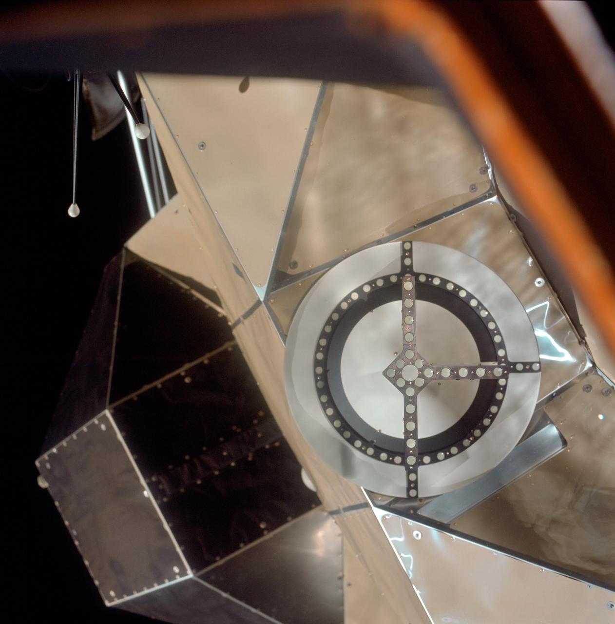
A close-up view of the Skylab space station cluster photographed against a black sky background from the Skylab 3 command module during the "fly around" inspection prior to docking. Note the one solar array system wing on the Orbital Workshop (OWS) which was successfully deployed during EVA on the first manned Skylab mission. The primary docking part at the forward end of the Multiple Docking Adapter (MDA) is visible below the Apollo Telescope Mount (ATM).
SL4-141-4340 (20 Jan. 1974) --- An oblique view of the southern part of the Sea of Okhotsk, north of Japan, as photographed from the Skylab space station in Earth orbit by one of the Skylab 4 crewmen. The camera used was a hand-held 70mm Hasselblad, and SO-368 medium-speed Ektachrome. NORTH IS AT THE TOP WHEN THE PICTURE IS HELD WITH THE LARGEST LAND MASS AT THE BOTTOM. Most of the land area is Hokkaido Island, Japan. The southern tip of Sakhalin Island (Soviet Union) is in the northwest corner. This photograph was taken to aid in the study of the formation of sea ice. Comparison of these photographs will be made with observations made during a joint USSR-U.S. experiment in the Bering Sea a year earlier. Observations in the Sea of Okhotsk are of interest because the ice has a morphology similar to that of the Bering Sea. Photo credit: NASA
AS09-23-3561 (3-13 March 1969) --- Near vertical view of the Lubbock area in west Texas as photographed from the Apollo 9 spacecraft during its Earth-orbital mission. Conspicuous patterns of farmland surround the city and extend eastward (up) to the Caprock Escarpment. The Double Mountain fork of the Brazos River drains east (toward upper center); Leeland is at lower center; Brownfield at lower right. The sharp edge of a cloud disk cuts across the upper right corner.

41G-102-047 (13 Oct. 1984) --- An unusual picture, photographed by astronaut Kathryn D. Sullivan, shows the beginning and ending location of her eight-day mission in space with six other 41-G crew members aboard the space shuttle Challenger. The picture was made moments before touchdown at the KSC landing facility. Dr. Sullivan aimed a 35mm camera through the port hole in Challenger's hatch. The five ground features represented as circles or pentagonals are launch areas. Photo credit: NASA
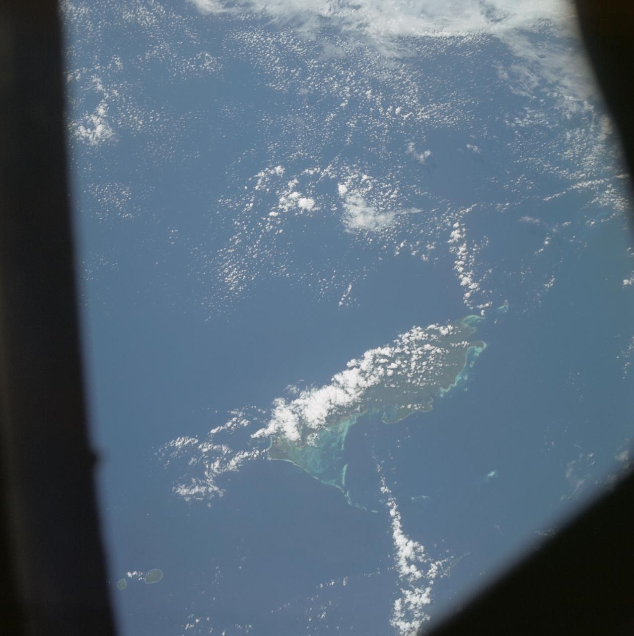
S66-54692 (14 Sept. 1966) --- Indonesian Islands (partial cloud cover): Sumatra, Java, Bali, Borneo, and Sumbawa, as photographed from the Gemini-11 spacecraft during its 26th revolution of Earth, at an altitude of 570 nautical miles. Photo credit: NASA
AS07-04-1609 (21 Oct. 1968) --- Woodlark Island in the Solomon Sea, east of New Guinea and northeast of Australia, as seen from the Apollo 7 spacecraft during its 158th revolution of Earth. Photographed from an altitude of 140 nautical miles, at ground elapsed time of 251 hours and 21 minutes.
AS10-27-3890 (18-26 May 1969) --- A view of Earth rising above the lunar horizon photographed from the Apollo 10 Lunar Module, looking west in the direction of travel. The Lunar Module at the time the picture was taken was located above the lunar farside highlands at approximately 105 degrees east longitude.

AS07-05-1652 (13 Oct. 1968) --- Pacific coast area of southwestern Mexico, State of Guerrero, from Acapulco to Tecoanapa, as seen from the Apollo 7 spacecraft during its 34th revolution of Earth. Photographed from an altitude of 125 nautical miles, at ground elapsed time of 54 hours and 10 minutes. Much cloud cover in area.