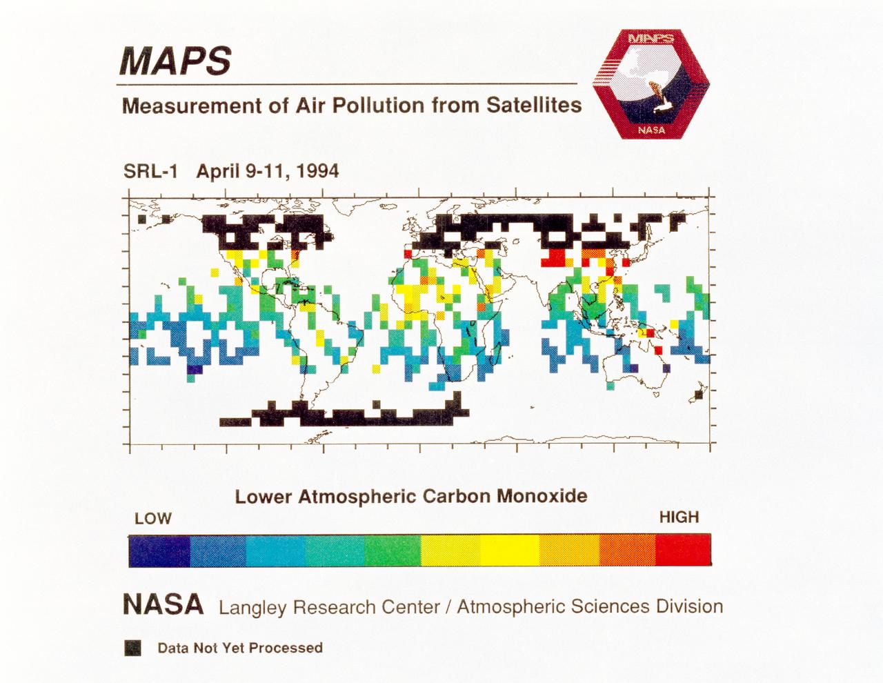
STS059-S-040 (12 April 1994) --- STS-59's MAPS (Measurement of Air Pollution from Satellites) experiment is sending real-time data that provides the most comprehensive view of carbon monoxide concentrations on Earth ever recorded. This computer image shows a summary of "quick look" data obtained by the MAPS instrument during its first days of operations as part of the Space Shuttle Endeavour's SRL-1 payload. This data will be processed using more sophisticated techniques following the flight. The color red indicates areas with the highest levels of carbon monoxide. These Northern Hemisphere springtime carbon monoxide values are generally significantly higher than the values found in the Southern Hemisphere. This is in direct contrast to the data obtained by the MAPS experiment during November 1981 and October 1984, i.e. during Northern Hemisphere fall. The astronauts aboard Endeavour have seen fires in most of the areas showing higher carbon monoxide values (China, Eastern Australia, and equatorial Africa). The relationship between the observed fires and the higher carbon monoxide values will be investigated following SRL-1 by combining the MAPS data with meteorological data, surface imagery, and Space Shuttle hand-held photographs. By the end of SRL-1, MAPS will have acquired data over most of the globe between 57 degrees north and 57 degrees south latitudes. The entire data set will be carefully analyzed using sophisticated post-flight data processing techniques. The data will then be applied in a variety of scientific studies concerning chemistry and transport processes in the atmosphere. The MAPS experiment measures the carbon monoxide in the lower atmosphere. This gas is produced both as a result of natural processes and as a result of human activities. The primary human resources of carbon monoxide are automobiles and industry and the burning of plant materials. The primary natural source is the interaction of sunlight with naturally occurring ozone and water vapor. The strength of all of these sources changes seasonally.
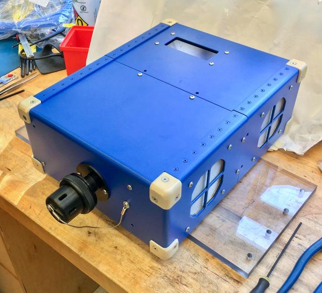
jsc2020e004941 (2/7/2020) --- A preflight view of the Airborne Particulate Monitor (APM) engineering unit. APM technology has applications in environmental monitoring and air pollution studies on Earth. Its combination of two instruments into one box offers a wider range of particle size measurement than other commercially available instruments.
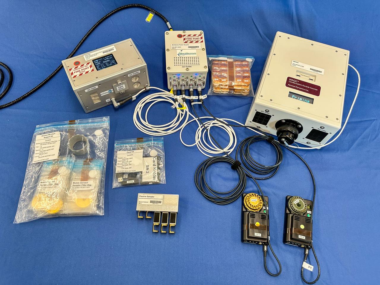
jsc2025e036188 (2/3/2025) --- A preflight image of the Exploration Aerosol Monitors (ExAM) hardware which includes the Moderated Aerosol Growth with Internal water Cycling (MAGIC) particle counter, the OPto-electrical Realtime Aerosol classifier (OPERA), the Mobile Aerosol Reference Samplers (MARS). Aerosol Monitors demonstrates technologies to continuously monitor the concentration of airborne pollutant particles, which must be kept within safe ranges, inside the International Space Station. Image courtesy of BioServe.
iss038e001785 (11/14/2013) --- Close-up view of DIAPASON in the U.S. Laboratory aboard the International Space Station (ISS). The DIAPASON conducts high-accuracy environmental control,pollution monitoring and particle recording with a simple instrument that captures nanoparticles.
iss038e001780 (11/14/2013) --- A view of NASA astronaut Rick Mastracchio, posing with DIAPASON, in the U.S. Laboratory aboard the International Space Station(ISS). The DIAPASON conducts high-accuracy environmental control,pollution monitoring and particle recording with a simple instrument that captures nanoparticles.

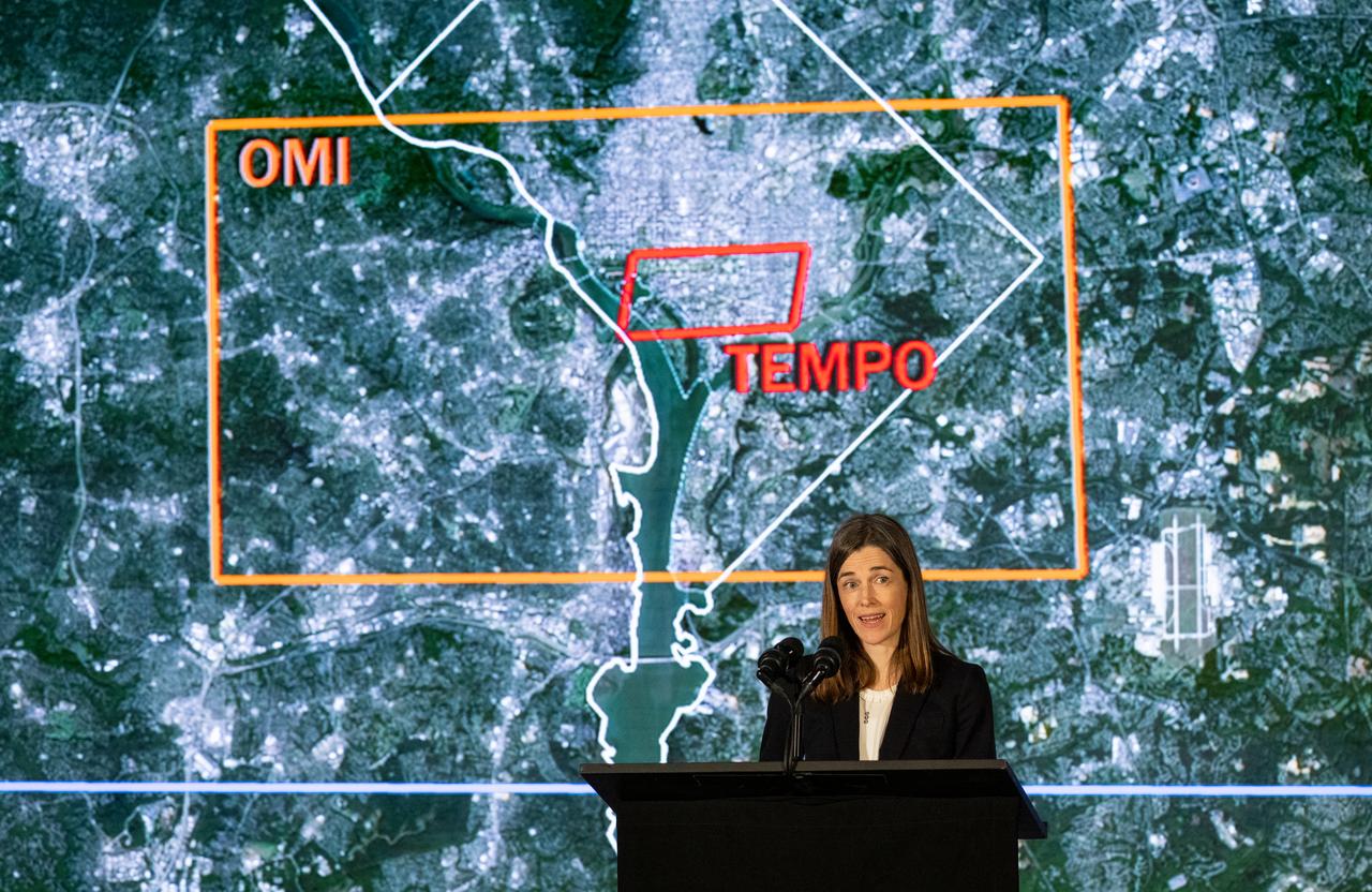
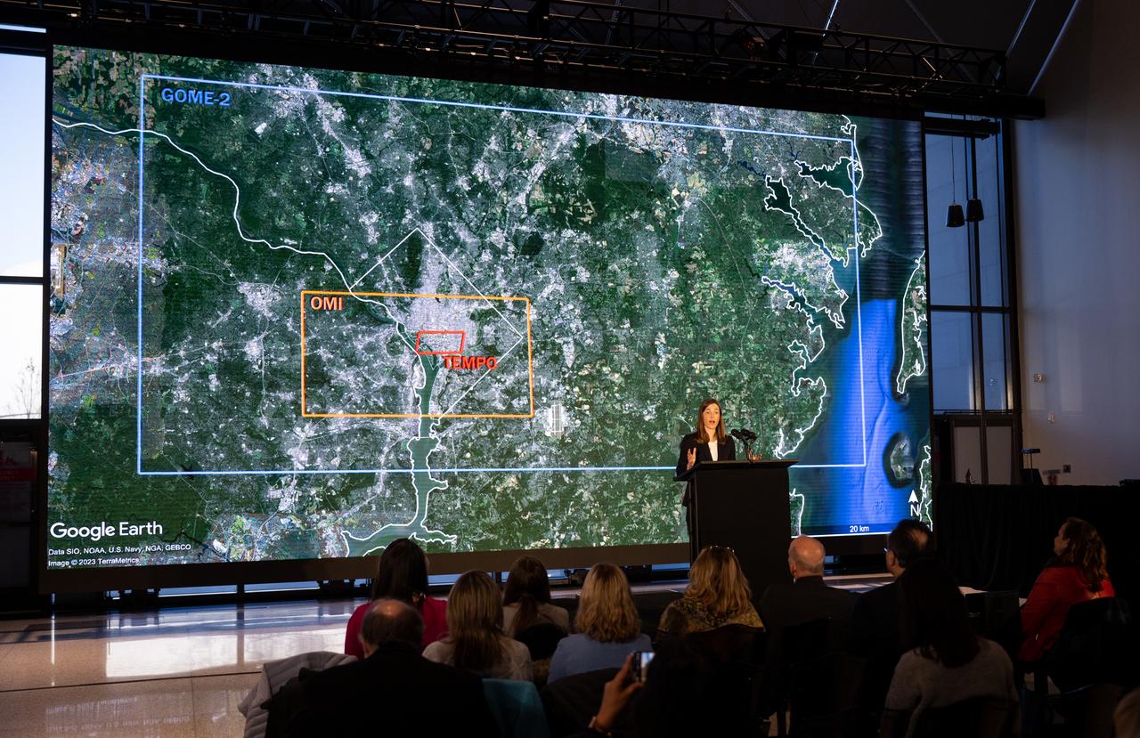
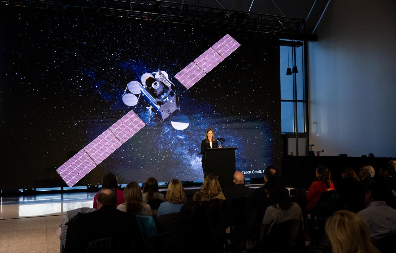
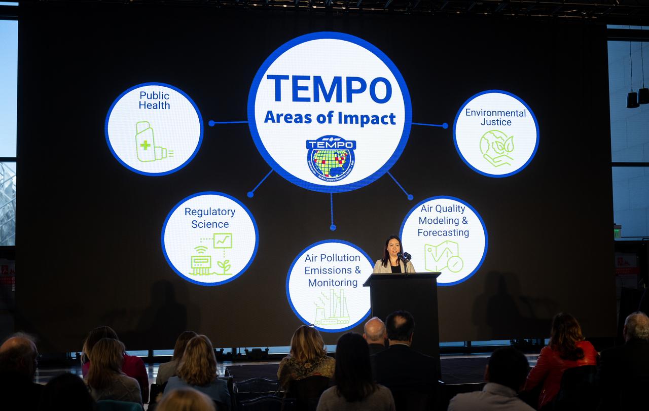
Erika Wright, education specialist at the Center for Astrophysics | Harvard & Smithsonian, speaks during a briefing on NASA’s TEMPO (Tropospheric Emissions: Monitoring of Pollution) instrument, Tuesday, March 14, 2023 at the Smithsonian’s National Air and Space Museum in Washington. NASA’s TEMPO instrument, the first Earth Venture Instrument mission, will measure air pollution across North America from Mexico City to the Canadian oil sands and from the Atlantic to the Pacific hourly and at a high spatial resolution. A partnership between NASA and the Center for Astrophysics | Harvard & Smithsonian, TEMPO will launch on a commercial satellite to geostationary orbit as early as April. Photo Credit: (NASA/Joel Kowsky)

Caroline Nowlan, atmospheric physicist at the Center for Astrophysics | Harvard & Smithsonian, speaks during a briefing on NASA’s TEMPO (Tropospheric Emissions: Monitoring of Pollution) instrument, Tuesday, March 14, 2023 at the Smithsonian’s National Air and Space Museum in Washington. NASA’s TEMPO instrument, the first Earth Venture Instrument mission, will measure air pollution across North America from Mexico City to the Canadian oil sands and from the Atlantic to the Pacific hourly and at a high spatial resolution. A partnership between NASA and the Center for Astrophysics | Harvard & Smithsonian, TEMPO will launch on a commercial satellite to geostationary orbit as early as April. Photo Credit: (NASA/Joel Kowsky)

Karen St. Germain, director of the Earth Science Division of NASA’s Science Mission Directorate, answers a question during a briefing on NASA’s TEMPO (Tropospheric Emissions: Monitoring of Pollution) instrument, Tuesday, March 14, 2023 at the Smithsonian’s National Air and Space Museum in Washington. NASA’s TEMPO instrument, the first Earth Venture Instrument mission, will measure air pollution across North America from Mexico City to the Canadian oil sands and from the Atlantic to the Pacific hourly and at a high spatial resolution. A partnership between NASA and the Center for Astrophysics | Harvard & Smithsonian, TEMPO will launch on a commercial satellite to geostationary orbit as early as April. Photo Credit: (NASA/Joel Kowsky)

Ellen Stofan, under secretary for Science and Research at the Smithsonian Institution, speaks during a briefing on NASA’s TEMPO (Tropospheric Emissions: Monitoring of Pollution) instrument, Tuesday, March 14, 2023 at the Smithsonian’s National Air and Space Museum in Washington. NASA’s TEMPO instrument, the first Earth Venture Instrument mission, will measure air pollution across North America from Mexico City to the Canadian oil sands and from the Atlantic to the Pacific hourly and at a high spatial resolution. A partnership between NASA and the Center for Astrophysics | Harvard & Smithsonian, TEMPO will launch on a commercial satellite to geostationary orbit as early as April. Photo Credit: (NASA/Joel Kowsky)

Barry Lefer, tropospheric composition program manager in the Earth Science Division of NASA’s Science Mission Directorate, speaks during a briefing on NASA’s TEMPO (Tropospheric Emissions: Monitoring of Pollution) instrument, Tuesday, March 14, 2023 at the Smithsonian’s National Air and Space Museum in Washington. NASA’s TEMPO instrument, the first Earth Venture Instrument mission, will measure air pollution across North America from Mexico City to the Canadian oil sands and from the Atlantic to the Pacific hourly and at a high spatial resolution. A partnership between NASA and the Center for Astrophysics | Harvard & Smithsonian, TEMPO will launch on a commercial satellite to geostationary orbit as early as April. Photo Credit: (NASA/Joel Kowsky)

Caroline Nowlan, atmospheric physicist at the Center for Astrophysics | Harvard & Smithsonian, speaks during a briefing on NASA’s TEMPO (Tropospheric Emissions: Monitoring of Pollution) instrument, Tuesday, March 14, 2023 at the Smithsonian’s National Air and Space Museum in Washington. NASA’s TEMPO instrument, the first Earth Venture Instrument mission, will measure air pollution across North America from Mexico City to the Canadian oil sands and from the Atlantic to the Pacific hourly and at a high spatial resolution. A partnership between NASA and the Center for Astrophysics | Harvard & Smithsonian, TEMPO will launch on a commercial satellite to geostationary orbit as early as April. Photo Credit: (NASA/Joel Kowsky)

Ellen Stofan, under secretary for Science and Research at the Smithsonian Institution, speaks during a briefing on NASA’s TEMPO (Tropospheric Emissions: Monitoring of Pollution) instrument, Tuesday, March 14, 2023 at the Smithsonian’s National Air and Space Museum in Washington. NASA’s TEMPO instrument, the first Earth Venture Instrument mission, will measure air pollution across North America from Mexico City to the Canadian oil sands and from the Atlantic to the Pacific hourly and at a high spatial resolution. A partnership between NASA and the Center for Astrophysics | Harvard & Smithsonian, TEMPO will launch on a commercial satellite to geostationary orbit as early as April. Photo Credit: (NASA/Joel Kowsky)

Karen St. Germain, director of the Earth Science Division of NASA’s Science Mission Directorate, speaks during a briefing on NASA’s TEMPO (Tropospheric Emissions: Monitoring of Pollution) instrument, Tuesday, March 14, 2023 at the Smithsonian’s National Air and Space Museum in Washington. NASA’s TEMPO instrument, the first Earth Venture Instrument mission, will measure air pollution across North America from Mexico City to the Canadian oil sands and from the Atlantic to the Pacific hourly and at a high spatial resolution. A partnership between NASA and the Center for Astrophysics | Harvard & Smithsonian, TEMPO will launch on a commercial satellite to geostationary orbit as early as April. Photo Credit: (NASA/Joel Kowsky)

Caroline Nowlan, atmospheric physicist at the Center for Astrophysics | Harvard & Smithsonian, answers a question during a briefing on NASA’s TEMPO (Tropospheric Emissions: Monitoring of Pollution) instrument, Tuesday, March 14, 2023 at the Smithsonian’s National Air and Space Museum in Washington. NASA’s TEMPO instrument, the first Earth Venture Instrument mission, will measure air pollution across North America from Mexico City to the Canadian oil sands and from the Atlantic to the Pacific hourly and at a high spatial resolution. A partnership between NASA and the Center for Astrophysics | Harvard & Smithsonian, TEMPO will launch on a commercial satellite to geostationary orbit as early as April. Photo Credit: (NASA/Joel Kowsky)

NASA Public Affairs Officer Karen Fox moderates a briefing on NASA’s TEMPO (Tropospheric Emissions: Monitoring of Pollution) instrument, Tuesday, March 14, 2023 at the Smithsonian’s National Air and Space Museum in Washington. NASA’s TEMPO instrument, the first Earth Venture Instrument mission, will measure air pollution across North America from Mexico City to the Canadian oil sands and from the Atlantic to the Pacific hourly and at a high spatial resolution. A partnership between NASA and the Center for Astrophysics | Harvard & Smithsonian, TEMPO will launch on a commercial satellite to geostationary orbit as early as April. Photo Credit: (NASA/Joel Kowsky)
Caroline Nowlan, atmospheric physicist at the Center for Astrophysics | Harvard & Smithsonian, speaks during a briefing on NASA’s TEMPO (Tropospheric Emissions: Monitoring of Pollution) instrument, Tuesday, March 14, 2023 at the Smithsonian’s National Air and Space Museum in Washington. NASA’s TEMPO instrument, the first Earth Venture Instrument mission, will measure air pollution across North America from Mexico City to the Canadian oil sands and from the Atlantic to the Pacific hourly and at a high spatial resolution. A partnership between NASA and the Center for Astrophysics | Harvard & Smithsonian, TEMPO will launch on a commercial satellite to geostationary orbit as early as April. Photo Credit: (NASA/Joel Kowsky)
Caroline Nowlan, atmospheric physicist at the Center for Astrophysics | Harvard & Smithsonian, speaks during a briefing on NASA’s TEMPO (Tropospheric Emissions: Monitoring of Pollution) instrument, Tuesday, March 14, 2023 at the Smithsonian’s National Air and Space Museum in Washington. NASA’s TEMPO instrument, the first Earth Venture Instrument mission, will measure air pollution across North America from Mexico City to the Canadian oil sands and from the Atlantic to the Pacific hourly and at a high spatial resolution. A partnership between NASA and the Center for Astrophysics | Harvard & Smithsonian, TEMPO will launch on a commercial satellite to geostationary orbit as early as April. Photo Credit: (NASA/Joel Kowsky)

Karen St. Germain, director of the Earth Science Division of NASA’s Science Mission Directorate, speaks during a briefing on NASA’s TEMPO (Tropospheric Emissions: Monitoring of Pollution) instrument, Tuesday, March 14, 2023 at the Smithsonian’s National Air and Space Museum in Washington. NASA’s TEMPO instrument, the first Earth Venture Instrument mission, will measure air pollution across North America from Mexico City to the Canadian oil sands and from the Atlantic to the Pacific hourly and at a high spatial resolution. A partnership between NASA and the Center for Astrophysics | Harvard & Smithsonian, TEMPO will launch on a commercial satellite to geostationary orbit as early as April. Photo Credit: (NASA/Joel Kowsky)

Karen St. Germain, director of the Earth Science Division of NASA’s Science Mission Directorate, speaks during a briefing on NASA’s TEMPO (Tropospheric Emissions: Monitoring of Pollution) instrument, Tuesday, March 14, 2023 at the Smithsonian’s National Air and Space Museum in Washington. NASA’s TEMPO instrument, the first Earth Venture Instrument mission, will measure air pollution across North America from Mexico City to the Canadian oil sands and from the Atlantic to the Pacific hourly and at a high spatial resolution. A partnership between NASA and the Center for Astrophysics | Harvard & Smithsonian, TEMPO will launch on a commercial satellite to geostationary orbit as early as April. Photo Credit: (NASA/Joel Kowsky)
Caroline Nowlan, atmospheric physicist at the Center for Astrophysics | Harvard & Smithsonian, speaks during a briefing on NASA’s TEMPO (Tropospheric Emissions: Monitoring of Pollution) instrument, Tuesday, March 14, 2023 at the Smithsonian’s National Air and Space Museum in Washington. NASA’s TEMPO instrument, the first Earth Venture Instrument mission, will measure air pollution across North America from Mexico City to the Canadian oil sands and from the Atlantic to the Pacific hourly and at a high spatial resolution. A partnership between NASA and the Center for Astrophysics | Harvard & Smithsonian, TEMPO will launch on a commercial satellite to geostationary orbit as early as April. Photo Credit: (NASA/Joel Kowsky)

Barry Lefer, tropospheric composition program manager in the Earth Science Division of NASA’s Science Mission Directorate, speaks during a briefing on NASA’s TEMPO (Tropospheric Emissions: Monitoring of Pollution) instrument, Tuesday, March 14, 2023 at the Smithsonian’s National Air and Space Museum in Washington. NASA’s TEMPO instrument, the first Earth Venture Instrument mission, will measure air pollution across North America from Mexico City to the Canadian oil sands and from the Atlantic to the Pacific hourly and at a high spatial resolution. A partnership between NASA and the Center for Astrophysics | Harvard & Smithsonian, TEMPO will launch on a commercial satellite to geostationary orbit as early as April. Photo Credit: (NASA/Joel Kowsky)

Barry Lefer, tropospheric composition program manager in the Earth Science Division of NASA’s Science Mission Directorate, speaks during a briefing on NASA’s TEMPO (Tropospheric Emissions: Monitoring of Pollution) instrument, Tuesday, March 14, 2023 at the Smithsonian’s National Air and Space Museum in Washington. NASA’s TEMPO instrument, the first Earth Venture Instrument mission, will measure air pollution across North America from Mexico City to the Canadian oil sands and from the Atlantic to the Pacific hourly and at a high spatial resolution. A partnership between NASA and the Center for Astrophysics | Harvard & Smithsonian, TEMPO will launch on a commercial satellite to geostationary orbit as early as April. Photo Credit: (NASA/Joel Kowsky)

Christopher Browne, director of the Smithsonian’s National Air and Space Museum delivers remarks during a briefing on NASA’s TEMPO (Tropospheric Emissions: Monitoring of Pollution) instrument, Tuesday, March 14, 2023 at the Smithsonian’s National Air and Space Museum in Washington. NASA’s TEMPO instrument, the first Earth Venture Instrument mission, will measure air pollution across North America from Mexico City to the Canadian oil sands and from the Atlantic to the Pacific hourly and at a high spatial resolution. A partnership between NASA and the Center for Astrophysics | Harvard & Smithsonian, TEMPO will launch on a commercial satellite to geostationary orbit as early as April. Photo Credit: (NASA/Joel Kowsky)
Karen St. Germain, director of the Earth Science Division of NASA’s Science Mission Directorate, speaks during a briefing on NASA’s TEMPO (Tropospheric Emissions: Monitoring of Pollution) instrument, Tuesday, March 14, 2023 at the Smithsonian’s National Air and Space Museum in Washington. NASA’s TEMPO instrument, the first Earth Venture Instrument mission, will measure air pollution across North America from Mexico City to the Canadian oil sands and from the Atlantic to the Pacific hourly and at a high spatial resolution. A partnership between NASA and the Center for Astrophysics | Harvard & Smithsonian, TEMPO will launch on a commercial satellite to geostationary orbit as early as April. Photo Credit: (NASA/Joel Kowsky)
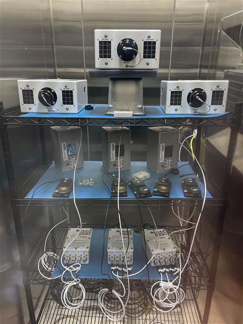
jsc2025e036187 (4/4/2025) --- The Exploration Aerosol Monitors (ExAM) hardware in BioServe Space Technologies’ environmental chamber: the Moderated Aerosol Growth with Internal water Cycling (MAGIC) particle counter (x3; top), the OPto-electrical Realtime Aerosol classifier (OPERA, x3; middle, back), the Mobile Aerosol Reference Samplers (MARS, x5; middle, front); power supplies (bottom). Aerosol Monitors demonstrates technologies to continuously monitor the concentration of airborne pollutant particles, which must be kept within safe ranges, inside the International Space Station.
Laura Judd, associate program manager for the Applied Sciences Health and Air Quality Applications in the Applied Sciences Program of NASA’s Earth Science Division, speaks during a briefing on NASA’s TEMPO (Tropospheric Emissions: Monitoring of Pollution) instrument, Tuesday, March 14, 2023 at the Smithsonian’s National Air and Space Museum in Washington. NASA’s TEMPO instrument, the first Earth Venture Instrument mission, will measure air pollution across North America from Mexico City to the Canadian oil sands and from the Atlantic to the Pacific hourly and at a high spatial resolution. A partnership between NASA and the Center for Astrophysics | Harvard & Smithsonian, TEMPO will launch on a commercial satellite to geostationary orbit as early as April. Photo Credit: (NASA/Joel Kowsky)

Laura Judd, associate program manager for the Applied Sciences Health and Air Quality Applications in the Applied Sciences Program of NASA’s Earth Science Division, speaks during a briefing on NASA’s TEMPO (Tropospheric Emissions: Monitoring of Pollution) instrument, Tuesday, March 14, 2023 at the Smithsonian’s National Air and Space Museum in Washington. NASA’s TEMPO instrument, the first Earth Venture Instrument mission, will measure air pollution across North America from Mexico City to the Canadian oil sands and from the Atlantic to the Pacific hourly and at a high spatial resolution. A partnership between NASA and the Center for Astrophysics | Harvard & Smithsonian, TEMPO will launch on a commercial satellite to geostationary orbit as early as April. Photo Credit: (NASA/Joel Kowsky)
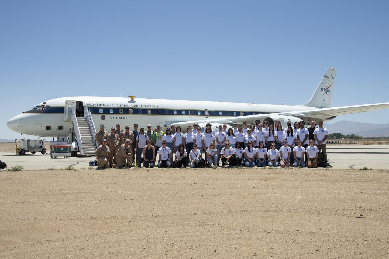
A group of university students and mentors flew aboard NASA Armstrong Flight Research Center’s DC-8 aircraft to study air quality as part of NASA’s Student Airborne Research Program (SARP). Based at NASA’s Armstrong Building 703 in Palmdale, California, the DC-8 flew over the Central Valley to measure pollution and monitor air quality on Tuesday, June 21, 2022.

Barry Lefer, tropospheric composition program manager in the Earth Science Division of NASA’s Science Mission Directorate, at podium, answers a question during a briefing on NASA’s TEMPO (Tropospheric Emissions: Monitoring of Pollution) instrument along with Caroline Nowlan, atmospheric physicist at the Center for Astrophysics | Harvard & Smithsonian, left, Karen St. Germain, director of the Earth Science Division of NASA’s Science Mission Directorate, second from left, Laura Judd, associate program manager for the Applied Sciences Health and Air Quality Applications in the Applied Sciences Program of NASA’s Earth Science Division, third from right, Erika Wright, education specialist at the Center for Astrophysics | Harvard & Smithsonian, second from right, and Karen Fox, NASA Public Affairs Officer, right, Tuesday, March 14, 2023 at the Smithsonian’s National Air and Space Museum in Washington. NASA’s TEMPO instrument, the first Earth Venture Instrument mission, will measure air pollution across North America from Mexico City to the Canadian oil sands and from the Atlantic to the Pacific hourly and at a high spatial resolution. A partnership between NASA and the Center for Astrophysics | Harvard & Smithsonian, TEMPO will launch on a commercial satellite to geostationary orbit as early as April. Photo Credit: (NASA/Joel Kowsky)
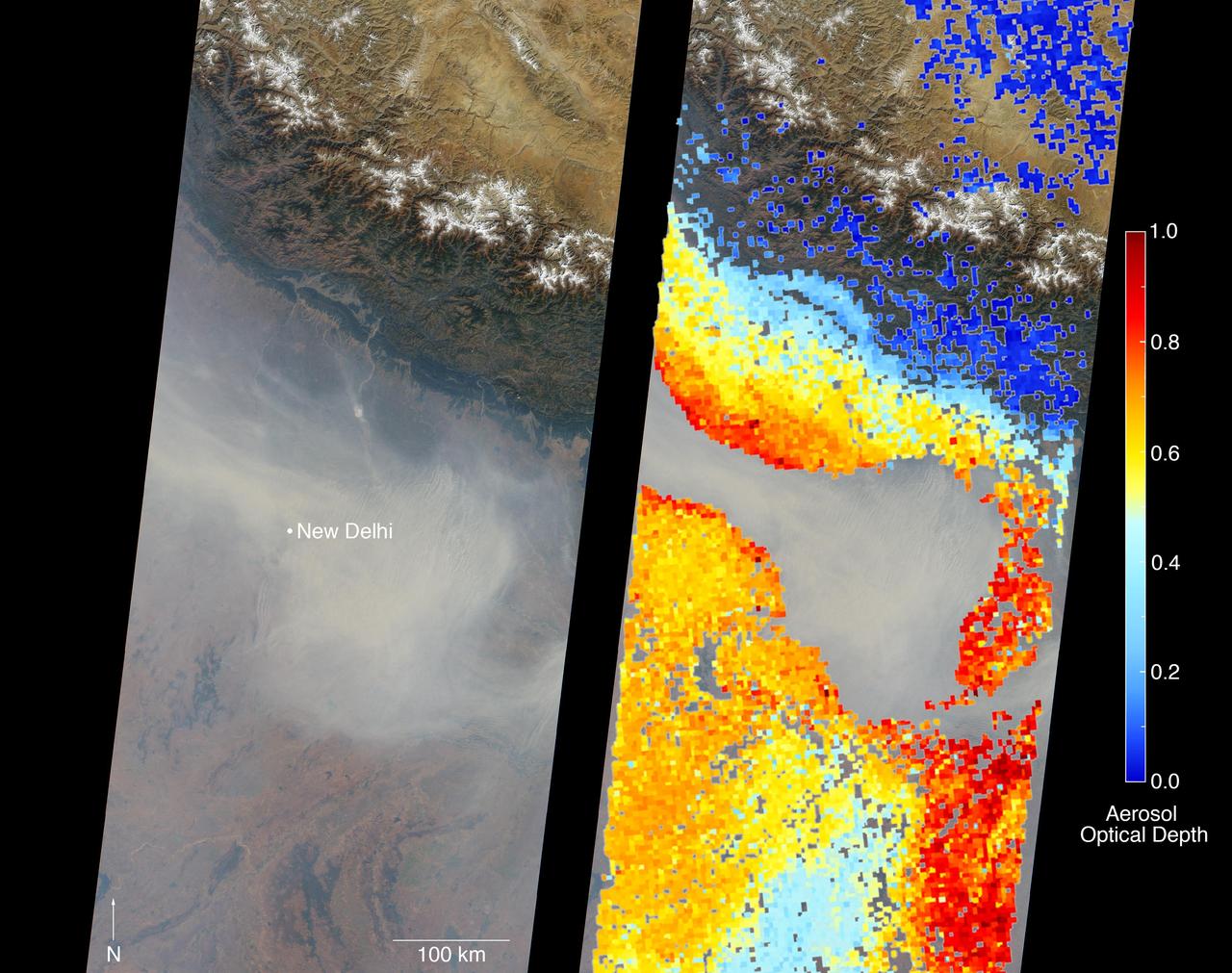
New Delhi, India's capital city, is currently suffering though a period of particularly poor air quality. In early November 2016, monitors at various locations in the area posted air quality index measurements as high as the 900s (the most severe ranking, "hazardous," is any air quality index measurement over 300). Thousands of schools have been closed, and a survey by the Associate Chambers of Commerce and Industry of India reports that 10 percent of the city's workers called in sick due to air-pollution-related health issues. According to several published news reports, the extreme air pollution may be due to a combination of nearby agricultural burning after harvest, urban construction and solid-waste burning, as well as remnants of firecracker smoke and additional car emissions after the celebration of Diwali, the Hindu festival of lights, on October 30. The Multi-angle Imaging SpectroRadiometer (MISR) instrument aboard NASA's Terra satellite passed over the region on Saturday, Nov. 5, 2016, at around 11:05 a.m. local time. At left is an image acquired from MISR's vertical viewing camera. The Himalayas stretch across the northern portion of the image. This towering mountain range tends to concentrate pollution in the region immediately to the south, including New Delhi, by preventing pollutants from blowing northwards. New Delhi, whose location is indicated on the image, is under a patch of especially thick haze. At 6:00 a.m. local time on that date, the U.S. Mission India NowCast Air Quality Index for New Delhi was reported at 751, more than twice the threshold for hazardous air quality. At right, a map of aerosol optical depth is superimposed on the image. Optical depth is a quantitative measure of the abundance of aerosols (tiny particles in the atmosphere). Optical depths for the area around New Delhi have not been calculated because the haze is so thick that the algorithm has classified the area as a cloud. In the region immediately surrounding the thick haze, optical depths approach 1.0. An optical depth of 1.0 means that only about 37 percent of direct sunlight reaches the surface due to interactions with particles in the atmosphere. These data were acquired during Terra orbit 89805. Other MISR data are available through the NASA Langley Research Center; for more information, go to https://eosweb.larc.nasa.gov/project/misr/misr_table. MISR was built and is managed by NASA's Jet Propulsion Laboratory, Pasadena, California, for NASA's Science Mission Directorate, Washington, D.C. The Terra spacecraft is managed by NASA's Goddard Space Flight Center, Greenbelt, Maryland. The MISR data were obtained from the NASA Langley Research Center Atmospheric Science Data Center, Hampton, Virginia. JPL is a division of the California Institute of Technology in Pasadena. http://photojournal.jpl.nasa.gov/catalog/PIA21100

The takeoff set the stage for a two-day Helios endurance flight in the stratosphere planned for mid-July. The Helios wing, spanning 247 feet and weighing about 2,400 pounds, is giving NASA and industry engineers confidence that remotely piloted aircraft will be able to stay aloft for weeks at a time, providing environmental monitoring capabilities and telecommunications relay services Helios is an all-electric airplane. In addition to being non-polluting, Helios can fly above storms, and use the power of the sun to stay aloft during daylight. Key to the success of this type of aircraft is the ability to fly in darkness, using fuel cells when sunlight cannot furnish energy. Helios flew over the Navy's Pacific Missile Range Facility where favorable sun exposure and test ranges closed to other air traffic benefited the NASA research effort. In 2003 the aircraft was lost to a crash.

The Anti-Atlas Mountains of Morocco formed as a result of the collision of the African and Eurasian tectonic plates about 80 million years ago. This collision destroyed the Tethys Ocean; the limestone, sandstone, claystone, and gypsum layers that formed the ocean bed were folded and crumpled to create the Anti-Atlas Mountains. In this ASTER image of southwest Morocco, visible, near infrared, and short wavelength infrared bands are combined to dramatically highlight the different rock types, and illustrate the complex folding. The ability to map geology using ASTER data is enhanced by bands that are sensitive to differences in rock mineralogy. The image was acquired on November 5, 2007, covers an area of 51.9 by 60.8 km, and is located at 28.1 degrees north and 10.7 degrees west. With its 14 spectral bands from the visible to the thermal infrared wavelength region and its high spatial resolution of about 50 to 300 feet (15 to 90 meters), ASTER images Earth to map and monitor the changing surface of our planet. ASTER is one of five Earth-observing instruments launched Dec. 18, 1999, on Terra. The instrument was built by Japan's Ministry of Economy, Trade and Industry. A joint U.S./Japan science team is responsible for validation and calibration of the instrument and data products. The broad spectral coverage and high spectral resolution of ASTER provides scientists in numerous disciplines with critical information for surface mapping and monitoring of dynamic conditions and temporal change. Example applications are monitoring glacial advances and retreats; monitoring potentially active volcanoes; identifying crop stress; determining cloud morphology and physical properties; wetlands evaluation; thermal pollution monitoring; coral reef degradation; surface temperature mapping of soils and geology; and measuring surface heat balance. https://photojournal.jpl.nasa.gov/catalog/PIA23533
Chausey is a group of small islands and islets off the coast of Normandy and is part of the French Channel Islands. Chausey bounced back and forth between England and France for 800 years before finally officially belonging to France in the 19th century. The archipelago comprises 365 islands at low tide (2019 image), compared to only 52 islands at high tide (2018 image). The images were acquired July 7, 2018 and September 10, 2019, cover an area of 6.7 by 10.5 km, and are located at 48.9 degrees north, 1.8 degrees west. With its 14 spectral bands from the visible to the thermal infrared wavelength region and its high spatial resolution of about 50 to 300 feet (15 to 90 meters), ASTER images Earth to map and monitor the changing surface of our planet. ASTER is one of five Earth-observing instruments launched Dec. 18, 1999, on Terra. The instrument was built by Japan's Ministry of Economy, Trade and Industry. A joint U.S./Japan science team is responsible for validation and calibration of the instrument and data products. The broad spectral coverage and high spectral resolution of ASTER provides scientists in numerous disciplines with critical information for surface mapping and monitoring of dynamic conditions and temporal change. Example applications are monitoring glacial advances and retreats; monitoring potentially active volcanoes; identifying crop stress; determining cloud morphology and physical properties; wetlands evaluation; thermal pollution monitoring; coral reef degradation; surface temperature mapping of soils and geology; and measuring surface heat balance. https://photojournal.jpl.nasa.gov/catalog/PIA25800
Mar Menor, in southeast Spain, is Europe's largest coastal saltwater lagoon. For the past 40 years, Mar Menor has faced severe contamination from agricultural runoff, leading to large algal blooms, and ecological degradation. Now, major restoration and prevention programs are in place to restore the lagoon, and try to reverse the damage. The image was acquired August 24, 2023, covers an area of 22.6 by 27.4 km, and is located at 37.7 degrees north, 0.8 degrees west. With its 14 spectral bands from the visible to the thermal infrared wavelength region and its high spatial resolution of about 50 to 300 feet (15 to 90 meters), ASTER images Earth to map and monitor the changing surface of our planet. ASTER is one of five Earth-observing instruments launched Dec. 18, 1999, on Terra. The instrument was built by Japan's Ministry of Economy, Trade and Industry. A joint U.S./Japan science team is responsible for validation and calibration of the instrument and data products. The broad spectral coverage and high spectral resolution of ASTER provides scientists in numerous disciplines with critical information for surface mapping and monitoring of dynamic conditions and temporal change. Example applications are monitoring glacial advances and retreats; monitoring potentially active volcanoes; identifying crop stress; determining cloud morphology and physical properties; wetlands evaluation; thermal pollution monitoring; coral reef degradation; surface temperature mapping of soils and geology; and measuring surface heat balance. https://photojournal.jpl.nasa.gov/catalog/PIA26009
Grande Comore is the largest island of the Union of the Comoros, an island nation located in the Mozambique Channel northwest of Madagascar. The nation was granted independence from France in 1975, and became the Federated Islamic Republic of the Comoro Islands. In 2001, the government reformed as the Union of the Comoros. The three islands making up the country are all of volcanic origin, and Grande Comore is still volcanically active. The image was acquired June 22, 2022, covers an area of 25.7 by 67.4 km, and is located at 11.7 degrees south, 43.3 degrees east. With its 14 spectral bands from the visible to the thermal infrared wavelength region and its high spatial resolution of about 50 to 300 feet (15 to 90 meters), ASTER images Earth to map and monitor the changing surface of our planet. ASTER is one of five Earth-observing instruments launched Dec. 18, 1999, on Terra. The instrument was built by Japan's Ministry of Economy, Trade and Industry. A joint U.S./Japan science team is responsible for validation and calibration of the instrument and data products. The broad spectral coverage and high spectral resolution of ASTER provides scientists in numerous disciplines with critical information for surface mapping and monitoring of dynamic conditions and temporal change. Example applications are monitoring glacial advances and retreats; monitoring potentially active volcanoes; identifying crop stress; determining cloud morphology and physical properties; wetlands evaluation; thermal pollution monitoring; coral reef degradation; surface temperature mapping of soils and geology; and measuring surface heat balance. https://photojournal.jpl.nasa.gov/catalog/PIA25444
![More than 70% of the world's hazelnuts come from Turkey, and about 60% come from the Eastern Black Sea region on the slopes of the Pontic mountain range, around the ancient coastal city of Giresun. The tradition of hazelnut farming goes back thousands of years. Presently, most of the hazelnut products are processed by women [BBC Travel]. The image was acquired August 15, 2024, covers an area of 35.7 by 36.2 km, and is located at 40.9 degrees north, 38.4 degrees east. With its 14 spectral bands from the visible to the thermal infrared wavelength region and its high spatial resolution of about 50 to 300 feet (15 to 90 meters), ASTER images Earth to map and monitor the changing surface of our planet. ASTER is one of five Earth-observing instruments launched Dec. 18, 1999, on Terra. The instrument was built by Japan's Ministry of Economy, Trade and Industry. A joint U.S./Japan science team is responsible for validation and calibration of the instrument and data products. The broad spectral coverage and high spectral resolution of ASTER provides scientists in numerous disciplines with critical information for surface mapping and monitoring of dynamic conditions and temporal change. Example applications are monitoring glacial advances and retreats; monitoring potentially active volcanoes; identifying crop stress; determining cloud morphology and physical properties; wetlands evaluation; thermal pollution monitoring; coral reef degradation; surface temperature mapping of soils and geology; and measuring surface heat balance. https://photojournal.jpl.nasa.gov/catalog/PIA26450](https://images-assets.nasa.gov/image/PIA26450/PIA26450~medium.jpg)
More than 70% of the world's hazelnuts come from Turkey, and about 60% come from the Eastern Black Sea region on the slopes of the Pontic mountain range, around the ancient coastal city of Giresun. The tradition of hazelnut farming goes back thousands of years. Presently, most of the hazelnut products are processed by women [BBC Travel]. The image was acquired August 15, 2024, covers an area of 35.7 by 36.2 km, and is located at 40.9 degrees north, 38.4 degrees east. With its 14 spectral bands from the visible to the thermal infrared wavelength region and its high spatial resolution of about 50 to 300 feet (15 to 90 meters), ASTER images Earth to map and monitor the changing surface of our planet. ASTER is one of five Earth-observing instruments launched Dec. 18, 1999, on Terra. The instrument was built by Japan's Ministry of Economy, Trade and Industry. A joint U.S./Japan science team is responsible for validation and calibration of the instrument and data products. The broad spectral coverage and high spectral resolution of ASTER provides scientists in numerous disciplines with critical information for surface mapping and monitoring of dynamic conditions and temporal change. Example applications are monitoring glacial advances and retreats; monitoring potentially active volcanoes; identifying crop stress; determining cloud morphology and physical properties; wetlands evaluation; thermal pollution monitoring; coral reef degradation; surface temperature mapping of soils and geology; and measuring surface heat balance. https://photojournal.jpl.nasa.gov/catalog/PIA26450

Super typhoon Mangkhut slammed into the northern Philippines on September 15 with wind speeds equivalent to a category 5 hurricane. South of where the eye made landfall, the storm's effects could be seen clearly five days later. The ASTER image of Dagupan and the Lingayen Gulf shows flooded and water-saturated areas in dark blue. Sediment-laden waters from swollen rivers enter the ocean and appear as blue-green plumes. The image was acquired September 22, 2018, covers an area of 51.4 by 61.2 kilometers, and is located at 16.2 degrees north, 120.3 degrees east. With its 14 spectral bands from the visible to the thermal infrared wavelength region and its high spatial resolution of about 50 to 300 feet (15 to 90 meters), ASTER images Earth to map and monitor the changing surface of our planet. ASTER is one of five Earth-observing instruments launched Dec. 18, 1999, on Terra. The instrument was built by Japan's Ministry of Economy, Trade and Industry. A joint U.S./Japan science team is responsible for validation and calibration of the instrument and data products. The broad spectral coverage and high spectral resolution of ASTER provides scientists in numerous disciplines with critical information for surface mapping and monitoring of dynamic conditions and temporal change. Example applications are monitoring glacial advances and retreats; monitoring potentially active volcanoes; identifying crop stress; determining cloud morphology and physical properties; wetlands evaluation; thermal pollution monitoring; coral reef degradation; surface temperature mapping of soils and geology; and measuring surface heat balance. https://photojournal.jpl.nasa.gov/catalog/PIA22705

Lake Mackay is the largest of hundreds of ephemeral lakes scattered throughout Western Australia and the Northern Territory, and is the second largest lake in Australia. The darker areas indicate some form of desert vegetation or algae, moisture within the soils, and lowest elevations where water pools. The image was acquired on September 19, 2010 and covers an area of 27 x 41 km. With its 14 spectral bands from the visible to the thermal infrared wavelength region and its high spatial resolution of 15 to 90 meters (about 50 to 300 feet), ASTER images Earth to map and monitor the changing surface of our planet. ASTER is one of five Earth-observing instruments launched Dec. 18, 1999, on Terra. The instrument was built by Japan's Ministry of Economy, Trade and Industry. A joint U.S./Japan science team is responsible for validation and calibration of the instrument and data products. The broad spectral coverage and high spectral resolution of ASTER provides scientists in numerous disciplines with critical information for surface mapping and monitoring of dynamic conditions and temporal change. Example applications are: monitoring glacial advances and retreats; monitoring potentially active volcanoes; identifying crop stress; determining cloud morphology and physical properties; wetlands evaluation; thermal pollution monitoring; coral reef degradation; surface temperature mapping of soils and geology; and measuring surface heat balance. The U.S. science team is located at NASA's Jet Propulsion Laboratory, Pasadena, Calif. The Terra mission is part of NASA's Science Mission Directorate, Washington, D.C. More information about ASTER is available at <a href="http://asterweb.jpl.nasa.gov/" rel="nofollow">asterweb.jpl.nasa.gov/</a>. Image Credit: NASA/GSFC/METI/ERSDAC/JAROS, and U.S./Japan ASTER Science Team
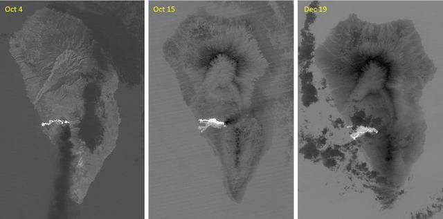
The major volcanic eruption of Cumbre Vieja volcano on La Palma, Canary Islands, began on September 21, 2021. For three months, lava poured out of the volcanic ridge, and flowed to the sea, engulfed 3000+ dwellings. The October 4 ASTER thermal infrared image shows the first flow reaching the coast. On October 15, a second flow followed to the north. By December 19, activity had stopped, and the flows are cooling. The images cover an area of 32.5 by 49.3 km, and are located at 28.6 degrees north, 17.9 degrees west. With its 14 spectral bands from the visible to the thermal infrared wavelength region and its high spatial resolution of about 50 to 300 feet (15 to 90 meters), ASTER images Earth to map and monitor the changing surface of our planet. ASTER is one of five Earth-observing instruments launched Dec. 18, 1999, on Terra. The instrument was built by Japan's Ministry of Economy, Trade and Industry. A joint U.S./Japan science team is responsible for validation and calibration of the instrument and data products. The broad spectral coverage and high spectral resolution of ASTER provides scientists in numerous disciplines with critical information for surface mapping and monitoring of dynamic conditions and temporal change. Example applications are monitoring glacial advances and retreats; monitoring potentially active volcanoes; identifying crop stress; determining cloud morphology and physical properties; wetlands evaluation; thermal pollution monitoring; coral reef degradation; surface temperature mapping of soils and geology; and measuring surface heat balance. https://photojournal.jpl.nasa.gov/catalog/PIA25085
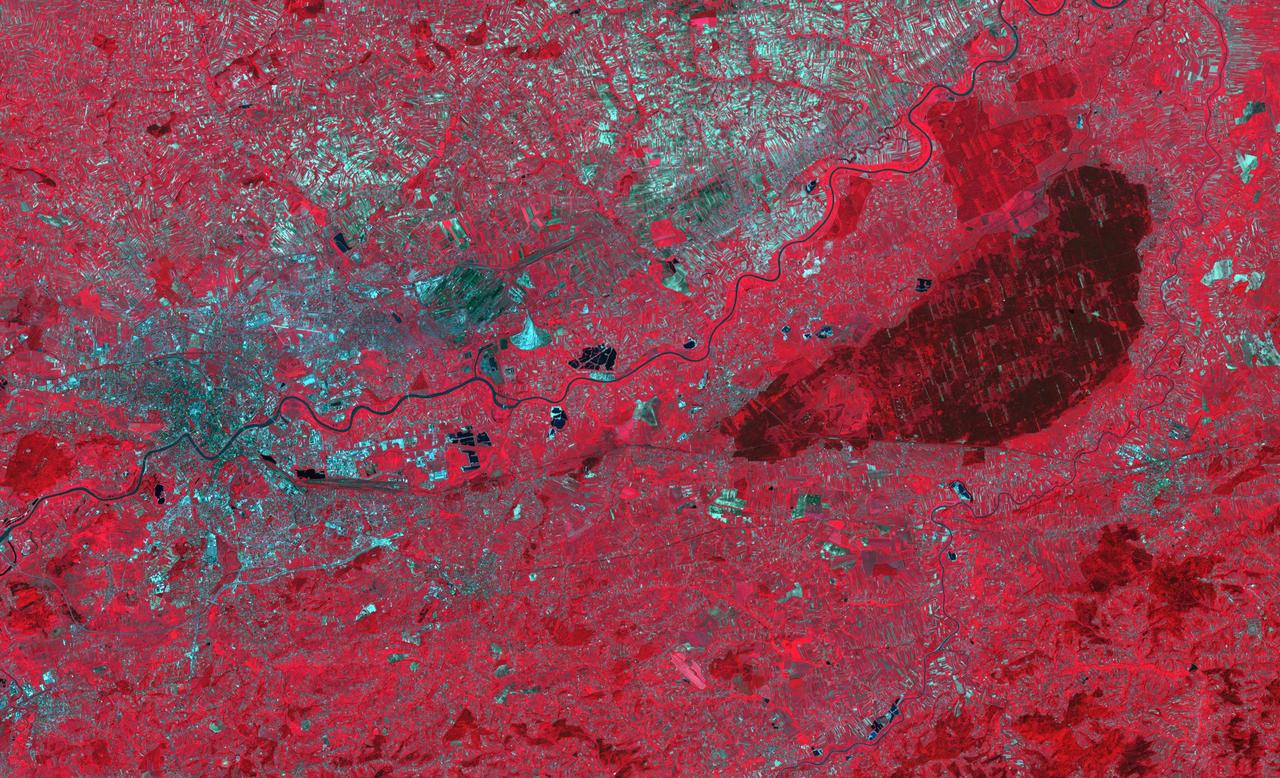
The Niepolmice Forest in Poland consists of six nature reserves, providing sanctuary for such threatened animals as lynx, wild cats and European Bison. Because of its proximity to Krakow, the old capital of Poland (left side of image), the forest (right side of image, dark red area) was a hunting ground for Polish Royalty beginning in the 13th century. The image was acquired May 25, 2003, covers an area of 29.5 by 48.5 km, and is located at 50 degrees north, 20.4 degrees east. With its 14 spectral bands from the visible to the thermal infrared wavelength region and its high spatial resolution of about 50 to 300 feet (15 to 90 meters), ASTER images Earth to map and monitor the changing surface of our planet. ASTER is one of five Earth-observing instruments launched Dec. 18, 1999, on Terra. The instrument was built by Japan's Ministry of Economy, Trade and Industry. A joint U.S./Japan science team is responsible for validation and calibration of the instrument and data products. The broad spectral coverage and high spectral resolution of ASTER provides scientists in numerous disciplines with critical information for surface mapping and monitoring of dynamic conditions and temporal change. Example applications are monitoring glacial advances and retreats; monitoring potentially active volcanoes; identifying crop stress; determining cloud morphology and physical properties; wetlands evaluation; thermal pollution monitoring; coral reef degradation; surface temperature mapping of soils and geology; and measuring surface heat balance. https://photojournal.jpl.nasa.gov/catalog/PIA23678
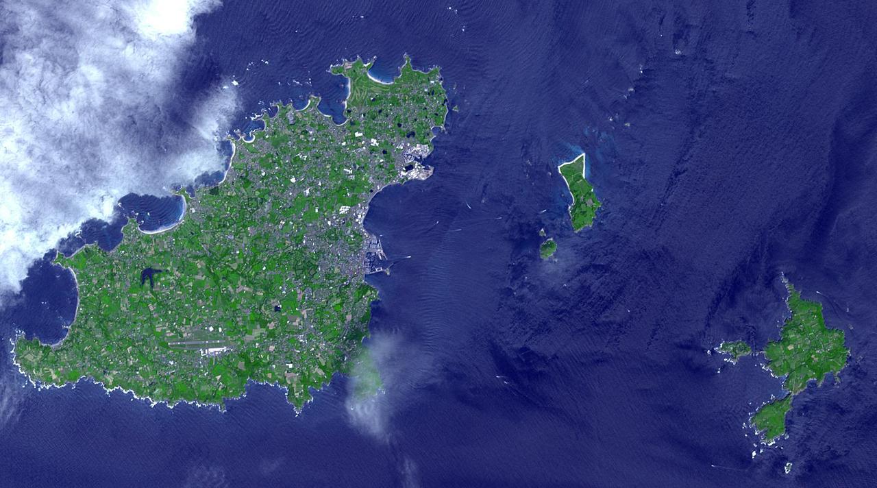
Sark (lower right) is part of the English Channel Islands off the coast of Normandy, France. It is a royal fief, part of the Bailiwick of Guernsey (left side), and has its own set of laws based on Norman law, its own parliament, and exchequer. Until 2008, it was the last feudal state in Europe with hereditary government. Sark is one of the few places in the world where cars are banned. The image was acquired June 16, 2017, covers an area of 14.1 by 25.3 km, and is located at 49.4 degrees north, 2.5 degrees west. With its 14 spectral bands from the visible to the thermal infrared wavelength region and its high spatial resolution of about 50 to 300 feet (15 to 90 meters), ASTER images Earth to map and monitor the changing surface of our planet. ASTER is one of five Earth-observing instruments launched Dec. 18, 1999, on Terra. The instrument was built by Japan's Ministry of Economy, Trade and Industry. A joint U.S./Japan science team is responsible for validation and calibration of the instrument and data products. The broad spectral coverage and high spectral resolution of ASTER provides scientists in numerous disciplines with critical information for surface mapping and monitoring of dynamic conditions and temporal change. Example applications are monitoring glacial advances and retreats; monitoring potentially active volcanoes; identifying crop stress; determining cloud morphology and physical properties; wetlands evaluation; thermal pollution monitoring; coral reef degradation; surface temperature mapping of soils and geology; and measuring surface heat balance. https://photojournal.jpl.nasa.gov/catalog/PIA25859
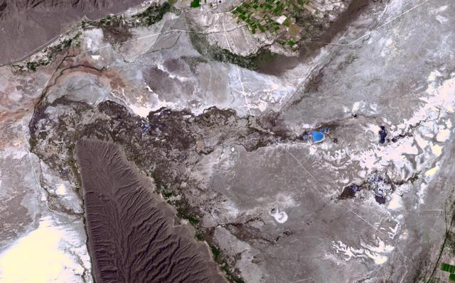
In the northern Mexican state of Cohuilla lies the Cuatro Cienegas Basin. Dotting the landscape are small pools, formed by natural springs, in which are found live stromatolites. These stony layered structures are formed by colonies of cyanobacteria that trap sedimentary grains. Their major presence in the fossil record of several billion years ago is evidence of some of the earliest form of life on Earth. NASA stated that the biological reserve of Cuatro Ciénegas could have strong links to discovering life on Mars, since the adaptability of bioforms in the region was unique in the world. The image was acquired April 1, 2017, covers an area of 14.9 by 23.8 km, and is located at 26.9 degrees north, 102.1 degrees west. With its 14 spectral bands from the visible to the thermal infrared wavelength region and its high spatial resolution of about 50 to 300 feet (15 to 90 meters), ASTER images Earth to map and monitor the changing surface of our planet. ASTER is one of five Earth-observing instruments launched Dec. 18, 1999, on Terra. The instrument was built by Japan's Ministry of Economy, Trade and Industry. A joint U.S./Japan science team is responsible for validation and calibration of the instrument and data products. The broad spectral coverage and high spectral resolution of ASTER provides scientists in numerous disciplines with critical information for surface mapping and monitoring of dynamic conditions and temporal change. Example applications are monitoring glacial advances and retreats; monitoring potentially active volcanoes; identifying crop stress; determining cloud morphology and physical properties; wetlands evaluation; thermal pollution monitoring; coral reef degradation; surface temperature mapping of soils and geology; and measuring surface heat balance. https://photojournal.jpl.nasa.gov/catalog/PIA23535
Hamelin Pool Marine Nature Reserve is located in the Shark Bay World Heritage Site in Western Australia. It is one of the very few places in the world where living stromatolites can be found. These are the first living examples of structures built by cyanobacteria. These bacteria are direct descendants of the oldest form of photosynthetic life on earth, dating back 3,500 million years (Wikipedia). The image was acquired December 30, 2010, covers an area of 34 x 46 km, and is located at 26.4 degrees south latitude, 114.1 degrees east longitude. With its 14 spectral bands from the visible to the thermal infrared wavelength region and its high spatial resolution of 15 to 90 meters (about 50 to 300 feet), ASTER images Earth to map and monitor the changing surface of our planet. ASTER is one of five Earth-observing instruments launched Dec. 18, 1999, on Terra. The instrument was built by Japan's Ministry of Economy, Trade and Industry. A joint U.S./Japan science team is responsible for validation and calibration of the instrument and data products. The broad spectral coverage and high spectral resolution of ASTER provides scientists in numerous disciplines with critical information for surface mapping and monitoring of dynamic conditions and temporal change. Example applications are: monitoring glacial advances and retreats; monitoring potentially active volcanoes; identifying crop stress; determining cloud morphology and physical properties; wetlands evaluation; thermal pollution monitoring; coral reef degradation; surface temperature mapping of soils and geology; and measuring surface heat balance. The U.S. science team is located at NASA's Jet Propulsion Laboratory, Pasadena, Calif. The Terra mission is part of NASA's Science Mission Directorate, Washington, D.C. More information about ASTER is available at <a href="http://asterweb.jpl.nasa.gov/" rel="nofollow">asterweb.jpl.nasa.gov/</a>. Credit: NASA/GSFC/METI/ERSDAC/JAROS, and U.S./Japan ASTER Science Team Image Addition Date: 2013-03-15 <b><a href="http://www.nasa.gov/audience/formedia/features/MP_Photo_Guidelines.html" rel="nofollow">NASA image use policy.</a></b> <b><a href="http://www.nasa.gov/centers/goddard/home/index.html" rel="nofollow">NASA Goddard Space Flight Center</a></b> enables NASA’s mission through four scientific endeavors: Earth Science, Heliophysics, Solar System Exploration, and Astrophysics. Goddard plays a leading role in NASA’s accomplishments by contributing compelling scientific knowledge to advance the Agency’s mission. <b>Follow us on <a href="http://twitter.com/NASA_GoddardPix" rel="nofollow">Twitter</a></b> <b>Like us on <a href="http://www.facebook.com/pages/Greenbelt-MD/NASA-Goddard/395013845897?ref=tsd" rel="nofollow">Facebook</a></b> <b>Find us on <a href="http://instagram.com/nasagoddard?vm=grid" rel="nofollow">Instagram</a></b>
The National Aeronautics and Space Administration (NASA) Lewis Research Center’s Convair F-106B Delta Dart equipped with air sampling equipment in the mid-1970s. NASA Lewis created and managed the Global Air Sampling Program (GASP) in 1972 in partnership with several airline companies. NASA researchers used the airliners’ Boeing 747 aircraft to gather air samples to determine the amount of pollution present in the stratosphere. Private companies developed the air sampling equipment for the GASP program, and Lewis created a particle collector. The collector was flight tested on NASA Lewis’ F-106B in the summer of 1973. The sampling equipment was automatically operated once the proper altitude was achieved. The sampling instruments collected dust particles in the air so their chemical composition could be analyzed. The equipment analyzed one second’s worth of data at a time. The researchers also monitored carbon monoxide, monozide, ozone, and water vapor. The 747 flights began in December 1974 and soon included four airlines flying routes all over the globe. The F-106B augmented the airline data with sampling of its own, seen here. It gathered samples throughout this period from locations such as New Mexico, Texas, Michigan, and Ohio. In July 1977 the F-106B flew eight GASP flights in nine days over Alaska to supplement the earlier data gathered by the airlines.
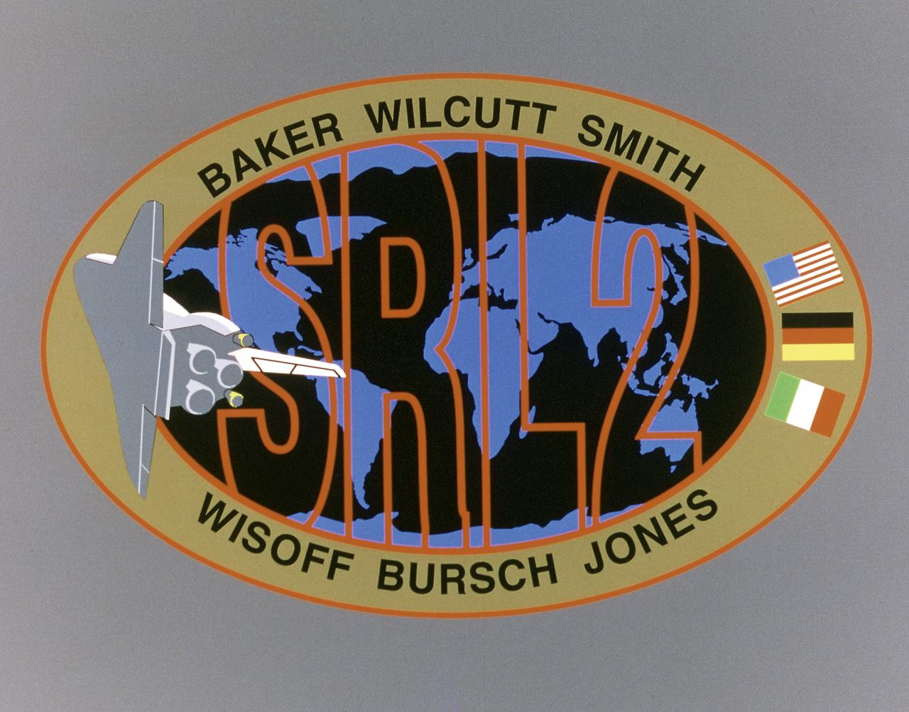
This STS-68 patch was designed by artist Sean Collins. Exploration of Earth from space is the focus of the design of the insignia, the second flight of the Space Radar Laboratory (SRL-2). SRL-2 was part of NASA's Mission to Planet Earth (MTPE) project. The world's land masses and oceans dominate the center field, with the Space Shuttle Endeavour circling the globe. The SRL-2 letters span the width and breadth of planet Earth, symbolizing worldwide coverage of the two prime experiments of STS-68: The Shuttle Imaging Radar-C and X-Band Synthetic Aperture Radar (SIR-C/X-SAR) instruments; and the Measurement of Air Pollution from Satellites (MAPS) sensor. The red, blue, and black colors of the insignia represent the three operating wavelengths of SIR-C/X-SAR, and the gold band surrounding the globe symbolizes the atmospheric envelope examined by MAPS. The flags of international partners Germany and Italy are shown opposite Endeavour. The relationship of the Orbiter to Earth highlights the usefulness of human space flights in understanding Earth's environment, and the monitoring of its changing surface and atmosphere. In the words of the crew members, the soaring Orbiter also typifies the excellence of the NASA team in exploring our own world, using the tools which the Space Program developed to explore the other planets in the solar system.
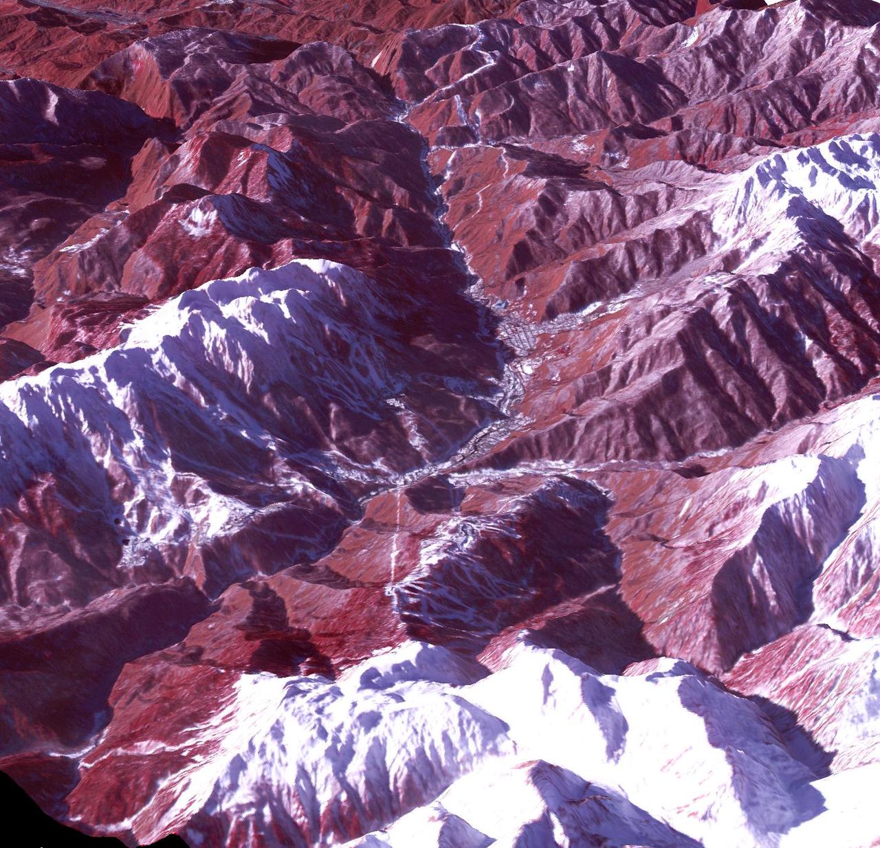
On September 24 at 11:29 GMT, a magnitude 7.7 earthquake struck in south-central Pakistan at a relatively shallow depth of 20 kilometers. The earthquake occurred as the result of oblique strike-slip motion, consistent with rupture within the Eurasian tectonic plate. Tremors were felt as far away as New Delhi as well as Karachi in Pakistan. Even though the immediate area to the epicenter is sparsely populated, the majority of houses are of mud brick construction and damage is expected to be extensive. The perspective view, looking to the east, shows the location of the epicenter in Pakistan's Makran fold belt. The image is centered near 27 degrees north latitude, 65.5 degrees east longitude, and was acquired December 13, 2012. With its 14 spectral bands from the visible to the thermal infrared wavelength region and its high spatial resolution of 15 to 90 meters (about 50 to 300 feet), ASTER images Earth to map and monitor the changing surface of our planet. ASTER is one of five Earth-observing instruments launched Dec. 18, 1999, on Terra. The instrument was built by Japan's Ministry of Economy, Trade and Industry. A joint U.S./Japan science team is responsible for validation and calibration of the instrument and data products. The broad spectral coverage and high spectral resolution of ASTER provides scientists in numerous disciplines with critical information for surface mapping and monitoring of dynamic conditions and temporal change. Example applications are: monitoring glacial advances and retreats; monitoring potentially active volcanoes; identifying crop stress; determining cloud morphology and physical properties; wetlands evaluation; thermal pollution monitoring; coral reef degradation; surface temperature mapping of soils and geology; and measuring surface heat balance. The U.S. science team is located at NASA's Jet Propulsion Laboratory, Pasadena, Calif. The Terra mission is part of NASA's Science Mission Directorate, Washington, D.C. More information about ASTER is available at <a href="http://asterweb.jpl.nasa.gov/" rel="nofollow">asterweb.jpl.nasa.gov/</a>. Image Credit: NASA/GSFC/METI/ERSDAC/JAROS, and U.S./Japan ASTER Science Team Image Addition Date: 2013-09-24 <b><a href="http://www.nasa.gov/audience/formedia/features/MP_Photo_Guidelines.html" rel="nofollow">NASA image use policy.</a></b> <b><a href="http://www.nasa.gov/centers/goddard/home/index.html" rel="nofollow">NASA Goddard Space Flight Center</a></b> enables NASA’s mission through four scientific endeavors: Earth Science, Heliophysics, Solar System Exploration, and Astrophysics. Goddard plays a leading role in NASA’s accomplishments by contributing compelling scientific knowledge to advance the Agency’s mission. <b>Follow us on <a href="http://twitter.com/NASA_GoddardPix" rel="nofollow">Twitter</a></b> <b>Like us on <a href="http://www.facebook.com/pages/Greenbelt-MD/NASA-Goddard/395013845897?ref=tsd" rel="nofollow">Facebook</a></b> <b>Find us on <a href="http://instagram.com/nasagoddard?vm=grid" rel="nofollow">Instagram</a></b>
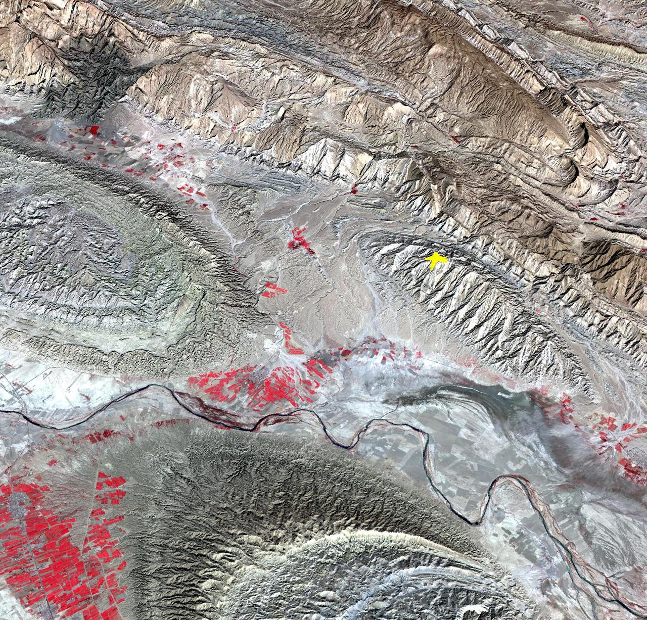
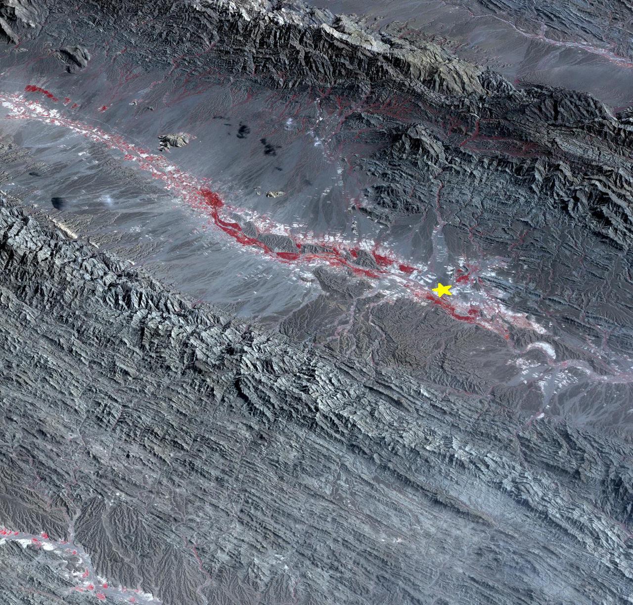
On April 9, 2013 at 11:52 GMT, a magnitude 6.3 earthquake hit southwestern Iran's Bushehr province near the town of Kaki. Preliminary information is that several villages have been destroyed and many people have died, as reported by BBC News. This perspective view of the region was acquired Nov. 17, 2012, by the Advanced Spaceborne Thermal Emission and Reflection Radiometer (ASTER) instrument on NASA's Terra spacecraft. The location of the earthquake's epicenter is marked with a yellow star. Vegetation is displayed in red; the vertical exaggeration of the topography is 2X. The image is centered near 28.5 degrees north latitude, 51.6 degrees east longitude. With its 14 spectral bands from the visible to the thermal infrared wavelength region and its high spatial resolution of 15 to 90 meters (about 50 to 300 feet), ASTER images Earth to map and monitor the changing surface of our planet. ASTER is one of five Earth-observing instruments launched Dec. 18, 1999, on Terra. The instrument was built by Japan's Ministry of Economy, Trade and Industry. A joint U.S./Japan science team is responsible for validation and calibration of the instrument and data products. The broad spectral coverage and high spectral resolution of ASTER provides scientists in numerous disciplines with critical information for surface mapping and monitoring of dynamic conditions and temporal change. Example applications are: monitoring glacial advances and retreats; monitoring potentially active volcanoes; identifying crop stress; determining cloud morphology and physical properties; wetlands evaluation; thermal pollution monitoring; coral reef degradation; surface temperature mapping of soils and geology; and measuring surface heat balance. The U.S. science team is located at NASA's Jet Propulsion Laboratory, Pasadena, Calif. The Terra mission is part of NASA's Science Mission Directorate, Washington, D.C. More information about ASTER is available at <a href="http://asterweb.jpl.nasa.gov/" rel="nofollow">asterweb.jpl.nasa.gov/</a>. Image Credit: NASA/GSFC/METI/ERSDAC/JAROS, and U.S./Japan ASTER Science Team Image Addition Date: 2013-04-10 <b><a href="http://www.nasa.gov/audience/formedia/features/MP_Photo_Guidelines.html" rel="nofollow">NASA image use policy.</a></b> <b><a href="http://www.nasa.gov/centers/goddard/home/index.html" rel="nofollow">NASA Goddard Space Flight Center</a></b> enables NASA’s mission through four scientific endeavors: Earth Science, Heliophysics, Solar System Exploration, and Astrophysics. Goddard plays a leading role in NASA’s accomplishments by contributing compelling scientific knowledge to advance the Agency’s mission. <b>Follow us on <a href="http://twitter.com/NASA_GoddardPix" rel="nofollow">Twitter</a></b> <b>Like us on <a href="http://www.facebook.com/pages/Greenbelt-MD/NASA-Goddard/395013845897?ref=tsd" rel="nofollow">Facebook</a></b> <b>Find us on <a href="http://instagram.com/nasagoddard?vm=grid" rel="nofollow">Instagram</a></b>
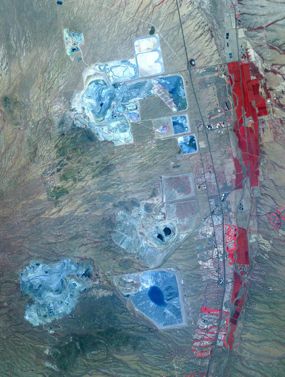
Arizona produces 60% of the total copper mined in the US; in 2007, 750,000 tons of copper came out of the state. One of the major mining districts is located about 30 km south of Tucson. Starting around 1950, open-pit mining replaced underground operations, and the ASARCO-Mission complex, Twin Buttes, and Sierrita mines became large open pit operations. Accompanying copper mineralization, silver, molybdenum, zinc, lead and gold are extracted. In addition to the pits themselves, enormous leach ponds and tailings piles surround the pits. The image was acquired May 31, 2012, covers an area of 22 by 28 km, and is located at 31.9 degrees north, 111 degrees west. With its 14 spectral bands from the visible to the thermal infrared wavelength region and its high spatial resolution of 15 to 90 meters (about 50 to 300 feet), ASTER images Earth to map and monitor the changing surface of our planet. ASTER is one of five Earth-observing instruments launched Dec. 18, 1999, on Terra. The instrument was built by Japan's Ministry of Economy, Trade and Industry. A joint U.S./Japan science team is responsible for validation and calibration of the instrument and data products. The broad spectral coverage and high spectral resolution of ASTER provides scientists in numerous disciplines with critical information for surface mapping and monitoring of dynamic conditions and temporal change. Example applications are: monitoring glacial advances and retreats; monitoring potentially active volcanoes; identifying crop stress; determining cloud morphology and physical properties; wetlands evaluation; thermal pollution monitoring; coral reef degradation; surface temperature mapping of soils and geology; and measuring surface heat balance. The U.S. science team is located at NASA's Jet Propulsion Laboratory, Pasadena, Calif. The Terra mission is part of NASA's Science Mission Directorate, Washington, D.C. More information about ASTER is available at <a href="http://asterweb.jpl.nasa.gov/" rel="nofollow">asterweb.jpl.nasa.gov/</a> Credit: NASA/GSFC/METI/ERSDAC/JAROS, and U.S./Japan ASTER Science Team <b><a href="http://www.nasa.gov/audience/formedia/features/MP_Photo_Guidelines.html" rel="nofollow">NASA image use policy.</a></b> <b><a href="http://www.nasa.gov/centers/goddard/home/index.html" rel="nofollow">NASA Goddard Space Flight Center</a></b> enables NASA’s mission through four scientific endeavors: Earth Science, Heliophysics, Solar System Exploration, and Astrophysics. Goddard plays a leading role in NASA’s accomplishments by contributing compelling scientific knowledge to advance the Agency’s mission. <b>Follow us on <a href="http://twitter.com/NASAGoddardPix" rel="nofollow">Twitter</a></b> <b>Like us on <a href="http://www.facebook.com/pages/Greenbelt-MD/NASA-Goddard/395013845897?ref=tsd" rel="nofollow">Facebook</a></b> <b>Find us on <a href="http://instagram.com/nasagoddard?vm=grid" rel="nofollow">Instagram</a></b>
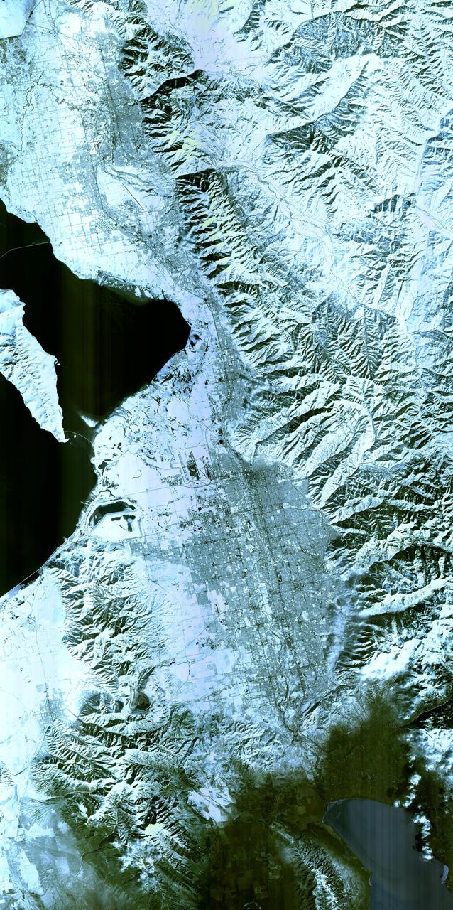
Salt Lake City, Utah, Winter 2001 The 2002 Winter Olympics are hosted by Salt Lake City at several venues within the city, in nearby cities, and within the adjacent Wasatch Mountains. This simulated natural color image presents a snowy, winter view of north central Utah that includes all of the Olympic sites. The image extends from Ogden in the north, to Provo in the south; and includes the snow-capped Wasatch Mountains and the eastern part of the Great Salt Lake. This image was acquired on February 8, 2001 by the Advanced Spaceborne Thermal Emission and Reflection Radiometer (ASTER) on NASA's Terra satellite. With its 14 spectral bands from the visible to the thermal infrared wavelength region, and its high spatial resolution of 15 to 90 meters (about 50 to 300 feet), ASTER will image Earth for the next 6 years to map and monitor the changing surface of our planet. ASTER is one of five Earth-observing instruments launched December 18,1999, on NASA's Terra satellite. The instrument was built by Japan's Ministry of Economy, Trade and Industry. A joint U.S./Japan science team is responsible for validation and calibration of the instrument and the data products. Dr. Anne Kahle at NASA's Jet Propulsion Laboratory, Pasadena, California, is the U.S. Science team leader; Bjorn Eng of JPL is the project manager. ASTER is the only high resolution imaging sensor on Terra. The Terra mission is part of NASA's Earth Science Enterprise, along-term research and technology program designed to examine Earth's land, oceans, atmosphere, ice and life as a total integrated system. The broad spectral coverage and high spectral resolution of ASTER will provide scientists in numerous disciplines with critical information for surface mapping, and monitoring dynamic conditions and temporal change. Example applications are: monitoring glacial advances and retreats; monitoring potentially active volcanoes; identifying crop stress; determining cloud morphology and physical properties; wetlands evaluation; thermal pollution monitoring; coral reef degradation; surface temperature mapping of soils and geology; and measuring surface heat balance. Image credit: NASA/GSFC/METI/ERSDAC/JAROS, and U.S./Japan ASTER Science Team Credit: <b><a href="http://www.earthobservatory.nasa.gov/" rel="nofollow"> NASA Earth Observatory</a></b> <b><a href="http://www.nasa.gov/audience/formedia/features/MP_Photo_Guidelines.html" rel="nofollow">NASA image use policy.</a></b> <b><a href="http://www.nasa.gov/centers/goddard/home/index.html" rel="nofollow">NASA Goddard Space Flight Center</a></b> enables NASA’s mission through four scientific endeavors: Earth Science, Heliophysics, Solar System Exploration, and Astrophysics. Goddard plays a leading role in NASA’s accomplishments by contributing compelling scientific knowledge to advance the Agency’s mission. <b>Follow us on <a href="http://twitter.com/NASAGoddardPix" rel="nofollow">Twitter</a></b> <b>Like us on <a href="http://www.facebook.com/pages/Greenbelt-MD/NASA-Goddard/395013845897?ref=tsd" rel="nofollow">Facebook</a></b> <b>Find us on <a href="http://instagram.com/nasagoddard?vm=grid" rel="nofollow">Instagram</a></b>
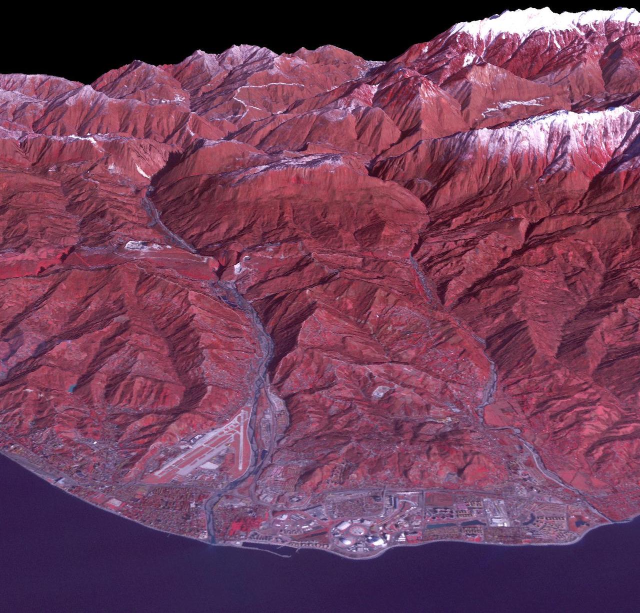
Sochi, Russia Winter Olympic Sites (Coastal Cluster) The Black Sea resort of Sochi, Russia, is the warmest city ever to host the Winter Olympic Games, which open on Feb. 7, 2014, and run through Feb. 23. This north-looking image, acquired on Jan. 4, 2014, by the Advanced Spaceborne Thermal Emission and Reflection Radiometer (ASTER) instrument on NASA's Terra spacecraft, shows the Sochi Olympic Park Coastal Cluster -- the circular area on the shoreline in the bottom center of the image -- which was built for Olympic indoor sports. Even curling has its own arena alongside multiple arenas for hockey and skating. The Olympic alpine events will take place at the Mountain Cluster, located in a snow-capped valley at the top right of the image. Sochi itself, a city of about 400,000, is not visible in the picture. It's farther west (left) along the coast, past the airport at bottom left. In the image, red indicates vegetation, white is snow, buildings are gray and the ocean is dark blue. The area imaged is about 15 miles (24 kilometers) from west to east (left to right) at the coastline and 25 miles (41 kilometers) from front to back. Height is exaggerated 1.5 times. The image was created from the ASTER visible and near-infrared bands, draped over ASTER-derived digital elevation data. With its 14 spectral bands from the visible to the thermal infrared wavelength region and its high spatial resolution of 15 to 90 meters (about 50 to 300 feet), ASTER images Earth to map and monitor the changing surface of our planet. ASTER is one of five Earth-observing instruments launched Dec. 18, 1999, on Terra. The instrument was built by Japan's Ministry of Economy, Trade and Industry. A joint U.S./Japan science team is responsible for validation and calibration of the instrument and data products. The broad spectral coverage and high spectral resolution of ASTER provides scientists in numerous disciplines with critical information for surface mapping and monitoring of dynamic conditions and temporal change. Example applications are: monitoring glacial advances and retreats; monitoring potentially active volcanoes; identifying crop stress; determining cloud morphology and physical properties; wetlands evaluation; thermal pollution monitoring; coral reef degradation; surface temperature mapping of soils and geology; and measuring surface heat balance. The U.S. science team is located at NASA's Jet Propulsion Laboratory, Pasadena, Calif. The Terra mission is part of NASA's Science Mission Directorate, Washington, D.C. More information about ASTER is available at <a href="http://asterweb.jpl.nasa.gov/" rel="nofollow">asterweb.jpl.nasa.gov/</a>. Image credit: NASA/GSFC/METI/ERSDAC/JAROS, and U.S./Japan ASTER Science Team <b><a href="http://www.nasa.gov/audience/formedia/features/MP_Photo_Guidelines.html" rel="nofollow">NASA image use policy.</a></b> <b><a href="http://www.nasa.gov/centers/goddard/home/index.html" rel="nofollow">NASA Goddard Space Flight Center</a></b> enables NASA’s mission through four scientific endeavors: Earth Science, Heliophysics, Solar System Exploration, and Astrophysics. Goddard plays a leading role in NASA’s accomplishments by contributing compelling scientific knowledge to advance the Agency’s mission. <b>Follow us on <a href="http://twitter.com/NASAGoddardPix" rel="nofollow">Twitter</a></b> <b>Like us on <a href="http://www.facebook.com/pages/Greenbelt-MD/NASA-Goddard/395013845897?ref=tsd" rel="nofollow">Facebook</a></b> <b>Find us on <a href="http://instagram.com/nasagoddard?vm=grid" rel="nofollow">Instagram</a></b>
Sochi, Russia Winter Olympic Sites (Mountain Cluster) The 2014 Winter Olympic ski runs may be rated double black diamond, but they're not quite as steep as they appear in this image of the skiing and snowboarding sites for the Sochi Winter Olympic Games, acquired on Jan. 4, 2014, by the Advanced Spaceborne Thermal Emission and Reflection Radiometer (ASTER) instrument on NASA's Terra spacecraft. Rosa Khutar ski resort near Sochi, Russia, is in the valley at center, and the runs are visible on the shadowed slopes on the left-hand side of the valley. Height has been exaggerated 1.5 times to bring out topographic details. The games, which begin on Feb. 7 and continue for 17 days, feature six new skiing and boarding events plus the return of the legendary Jamaican bobsled team to the winter games for the first time since 2002. In this southwest-looking image, red indicates vegetation, white is snow, and the resort site appears in gray. The area imaged is about 11 miles (18 kilometers) across in the foreground and 20 miles (32 kilometers) from front to back. The image was created from the ASTER visible and near-infrared bands, draped over ASTER-derived digital elevation data. With its 14 spectral bands from the visible to the thermal infrared wavelength region and its high spatial resolution of 15 to 90 meters (about 50 to 300 feet), ASTER images Earth to map and monitor the changing surface of our planet. ASTER is one of five Earth-observing instruments launched Dec. 18, 1999, on Terra. The instrument was built by Japan's Ministry of Economy, Trade and Industry. A joint U.S./Japan science team is responsible for validation and calibration of the instrument and data products. The broad spectral coverage and high spectral resolution of ASTER provides scientists in numerous disciplines with critical information for surface mapping and monitoring of dynamic conditions and temporal change. Example applications are: monitoring glacial advances and retreats; monitoring potentially active volcanoes; identifying crop stress; determining cloud morphology and physical properties; wetlands evaluation; thermal pollution monitoring; coral reef degradation; surface temperature mapping of soils and geology; and measuring surface heat balance. The U.S. science team is located at NASA's Jet Propulsion Laboratory, Pasadena, Calif. The Terra mission is part of NASA's Science Mission Directorate, Washington, D.C. More information about ASTER is available at <a href="http://asterweb.jpl.nasa.gov/" rel="nofollow">asterweb.jpl.nasa.gov/</a>. credit:NASA/GSFC/METI/ERSDAC/JAROS, and U.S./Japan ASTER Science Team <b><a href="http://www.nasa.gov/audience/formedia/features/MP_Photo_Guidelines.html" rel="nofollow">NASA image use policy.</a></b> <b><a href="http://www.nasa.gov/centers/goddard/home/index.html" rel="nofollow">NASA Goddard Space Flight Center</a></b> enables NASA’s mission through four scientific endeavors: Earth Science, Heliophysics, Solar System Exploration, and Astrophysics. Goddard plays a leading role in NASA’s accomplishments by contributing compelling scientific knowledge to advance the Agency’s mission. <b>Follow us on <a href="http://twitter.com/NASAGoddardPix" rel="nofollow">Twitter</a></b> <b>Like us on <a href="http://www.facebook.com/pages/Greenbelt-MD/NASA-Goddard/395013845897?ref=tsd" rel="nofollow">Facebook</a></b> <b>Find us on <a href="http://instagram.com/nasagoddard?vm=grid" rel="nofollow">Instagram</a></b>

The first flight of a large aircraft to be powered by electric fuel cells began with a takeoff at 8:43 a.m. HST today from the Hawaiian island of Kauai. The Helios Prototype flying wing, built by AeroVironment, Inc., of Monrovia, Calif., as part of NASA's Environmental Research Aircraft and Sensor Technology (ERAST) program, used solar panels to power its 10 electric motors for takeoff and during daylight portions of its planned 20-hour shakedown flight. As sunlight diminishes, Helios will switch to a fuel cell system to continue flight into the night. The takeoff set the stage for a two-day Helios endurance flight in the stratosphere planned for mid-July. The Helios wing, spanning 247 feet and weighing about 2,400 pounds, is giving NASA and industry engineers confidence that remotely piloted aircraft will be able to stay aloft for weeks at a time, providing environmental monitoring capabilities and telecommunications relay services. Helios is an all-electric airplane. In addition to being non-polluting, Helios can fly above storms, and use the power of the sun to stay aloft during daylight. Key to the success of this type of aircraft is the ability to fly in darkness, using fuel cells when sunlight cannot furnish energy. Helios flew over the Navy's Pacific Missile Range Facility where favorable sun exposure and test ranges closed to other air traffic benefited the NASA research effort. In 2003 the aircraft was lost to a crash.

The first flight of a large aircraft to be powered by electric fuel cells began with a takeoff at 8:43 a.m. HST today from the Hawaiian island of Kauai. The Helios Prototype flying wing, built by AeroVironment, Inc., of Monrovia, Calif., as part of NASA's Environmental Research Aircraft and Sensor Technology (ERAST) program, used solar panels to power its 10 electric motors for takeoff and during daylight portions of its planned 20-hour shakedown flight. As sunlight diminishes, Helios will switch to a fuel cell system to continue flight into the night. The takeoff set the stage for a two-day Helios endurance flight in the stratosphere planned for mid-July. The Helios wing, spanning 247 feet and weighing about 2,400 pounds, is giving NASA and industry engineers confidence that remotely piloted aircraft will be able to stay aloft for weeks at a time, providing environmental monitoring capabilities and telecommunications relay services. Helios is an all-electric airplane. In addition to being non-polluting, Helios can fly above storms, and use the power of the sun to stay aloft during daylight. Key to the success of this type of aircraft is the ability to fly in darkness, using fuel cells when sunlight cannot furnish energy. Helios flew over the Navy's Pacific Missile Range Facility where favorable sun exposure and test ranges closed to other air traffic benefited the NASA research effort. In 2003 the aircraft was lost to a crash.
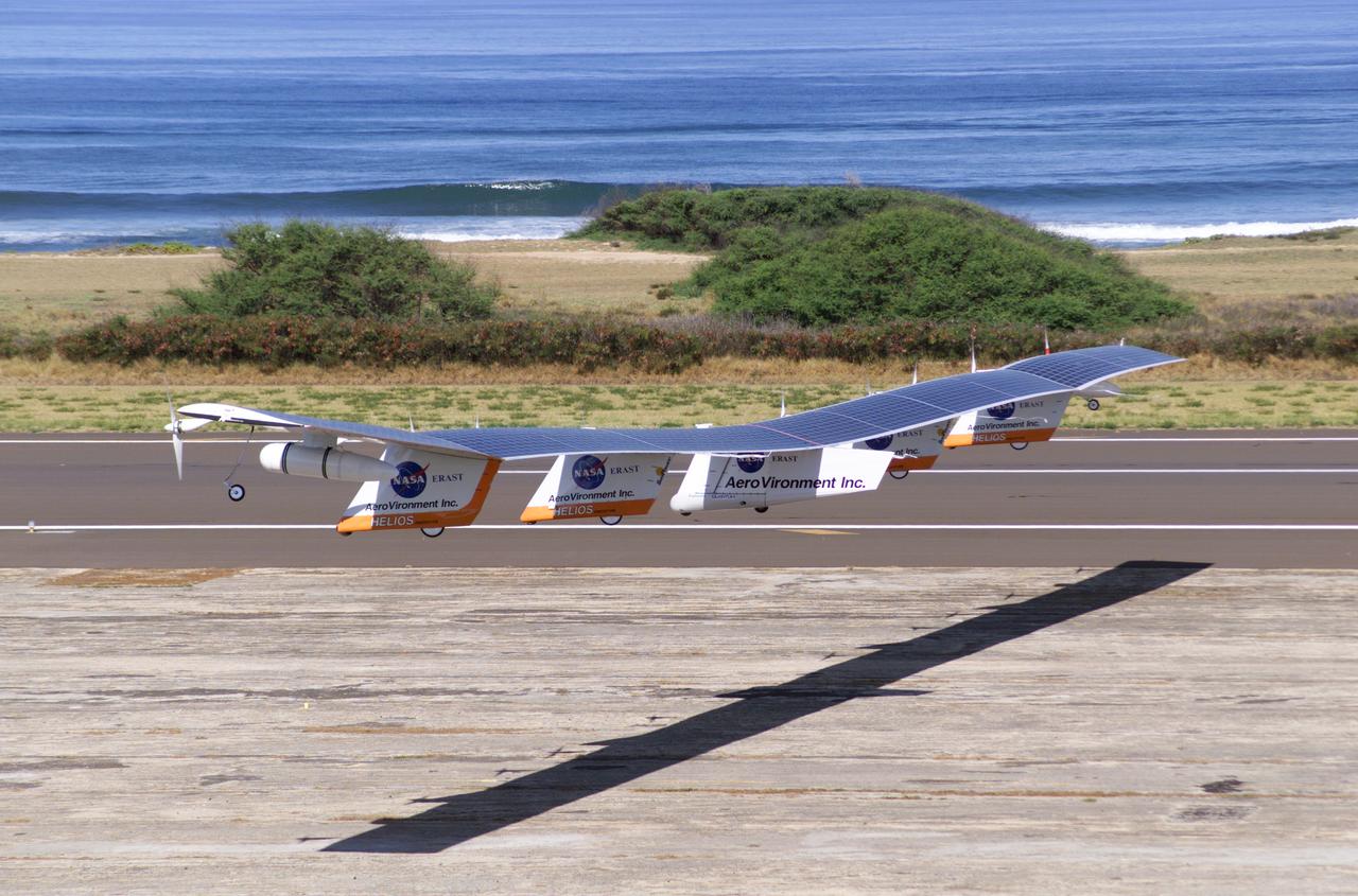
The first flight of a large aircraft to be powered by electric fuel cells began with a takeoff at 8:43 a.m. HST today from the Hawaiian island of Kauai. The Helios Prototype flying wing, built by AeroVironment, Inc., of Monrovia, Calif., as part of NASA's Environmental Research Aircraft and Sensor Technology (ERAST) program, used solar panels to power its 10 electric motors for takeoff and during daylight portions of its planned 20-hour shakedown flight. As sunlight diminishes, Helios will switch to a fuel cell system to continue flight into the night. The takeoff set the stage for a two-day Helios endurance flight in the stratosphere planned for mid-July. The Helios wing, spanning 247 feet and weighing about 2,400 pounds, gave NASA and industry engineers confidence that remotely piloted aircraft would be able to stay aloft for weeks at a time, providing environmental monitoring capabilities and telecommunications relay services. Helios was an all-electric airplane. In addition to being non-polluting, Helios flew above storms, and used the power of the sun to stay aloft during daylight. Key to the success of this type of aircraft was the ability to fly in darkness, using fuel cells when sunlight cannot furnish energy. Helios flew over the Navy's Pacific Missile Range Facility where favorable sun exposure and test ranges closed to other air traffic benefited the NASA research effort. In 2003 the aircraft was lost to a crash.
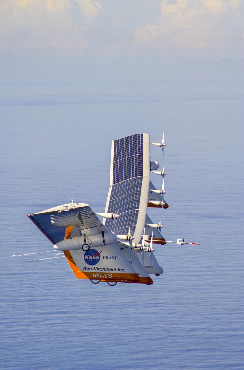
The first flight of a large aircraft to be powered by electric fuel cells began with a takeoff at 8:43 a.m. HST today from the Hawaiian island of Kauai. The Helios Prototype flying wing, built by AeroVironment, Inc., of Monrovia, Calif., as part of NASA's Environmental Research Aircraft and Sensor Technology (ERAST) program, used solar panels to power its 10 electric motors for takeoff and during daylight portions of its planned 20-hour shakedown flight. As sunlight diminishes, Helios will switch to a fuel cell system to continue flight into the night. The takeoff set the stage for a two-day Helios endurance flight in the stratosphere planned for mid-July. The Helios wing, spanning 247 feet and weighing about 2,400 pounds, is giving NASA and industry engineers confidence that remotely piloted aircraft will be able to stay aloft for weeks at a time, providing environmental monitoring capabilities and telecommunications relay services. Helios is an all-electric airplane. In addition to being non-polluting, Helios can fly above storms, and use the power of the sun to stay aloft during daylight. Key to the success of this type of aircraft is the ability to fly in darkness, using fuel cells when sunlight cannot furnish energy. Helios flew over the Navy's Pacific Missile Range Facility where favorable sun exposure and test ranges closed to other air traffic benefited the NASA research effort. In 2003 the aircraft was lost to a crash.
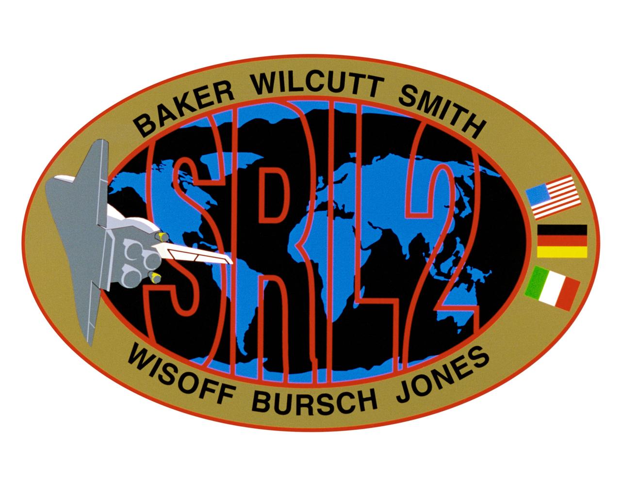
STS068-S-001 (March 1994) --- Exploration of Earth from space is the focus of the design of the STS-68 insignia, the second flight of the Space Radar Laboratory (SRL-2). SRL-2 is part of NASA's Mission to Planet Earth (MTPE) *project. The world's land masses and oceans dominate the center field, with the space shuttle Endeavour circling the globe. The SRL-2 letters span the width and breadth of planet Earth, symbolizing worldwide coverage of the two prime experiments of STS-68 - The Shuttle Imaging Radar-C and X-Band Synthetic Aperture Radar (SIR-C/X-SAR) instruments, and the Measurement of Air Pollution from Satellites (MAPS) sensor. The red, blue and black colors of the insignia represent the three operating wavelengths of SIR-C/X-SAR, and the gold band surrounding the globe symbolizes the atmospheric envelope examined by MAPS. The flags of international partners Germany and Italy are shown opposite Endeavour. The relationship of the orbiter to Earth highlights the usefulness of human spaceflights in understanding Earth's environment, and the monitoring its changing surface and atmosphere. In the words of the crew members, "the soaring orbiter also typifies the excellence of the NASA team in exploring our own world, using the tools which the Space Program developed to explore the other planets in the solar system". This STS-68 patch was designed by artist Sean Collins. The NASA insignia design for space shuttle flights is reserved for use by the astronauts and for other official use as the NASA Administrator may authorize. Public availability has been approved only in the forms of illustrations by the various news media. When and if there is any change in this policy, which is not anticipated, the change will be publicly announced. Photo credit: NASA
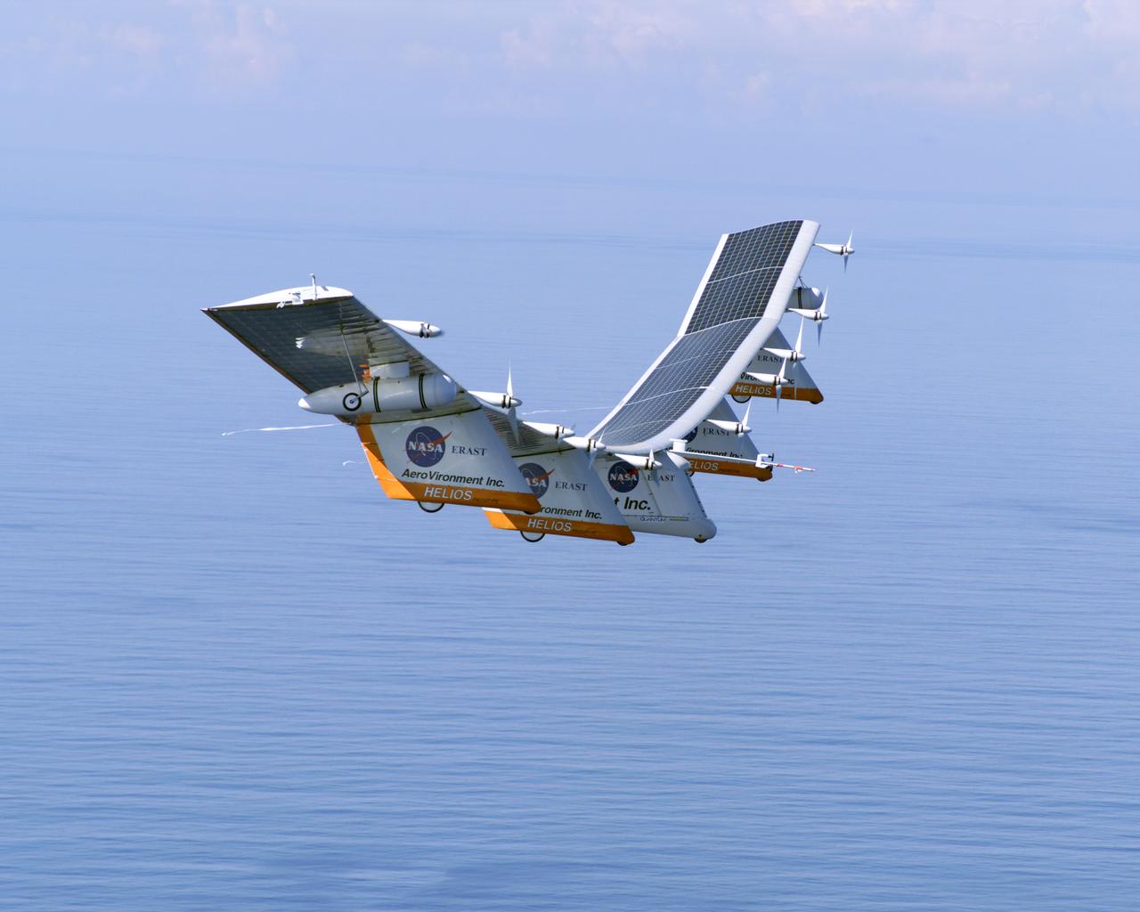
The first flight of a large aircraft to be powered by electric fuel cells began with a takeoff at 8:43 a.m. HST today from the Hawaiian island of Kauai. The Helios Prototype flying wing, built by AeroVironment, Inc., of Monrovia, Calif., as part of NASA's Environmental Research Aircraft and Sensor Technology (ERAST) program, used solar panels to power its 10 electric motors for takeoff and during daylight portions of its planned 20-hour shakedown flight. As sunlight diminishes, Helios will switch to a fuel cell system to continue flight into the night. The takeoff set the stage for a two-day Helios endurance flight in the stratosphere planned for mid-July. The Helios wing, spanning 247 feet and weighing about 2,400 pounds, is giving NASA and industry engineers confidence that remotely piloted aircraft will be able to stay aloft for weeks at a time, providing environmental monitoring capabilities and telecommunications relay services. Helios is an all-electric airplane. In addition to being non-polluting, Helios can fly above storms, and use the power of the sun to stay aloft during daylight. Key to the success of this type of aircraft is the ability to fly in darkness, using fuel cells when sunlight cannot furnish energy. Helios flew over the Navy's Pacific Missile Range Facility where favorable sun exposure and test ranges closed to other air traffic benefited the NASA research effort. In 2003 the aircraft was lost to a crash.
An aerial view of the Wallops Island launch facilities taken by the Wallops Incident Response Team Oct. 29 following the failed launch attempt of Orbital Science Corp.'s Antares rocket Oct. 28. Credit: NASA/Terry Zaperach --- The Wallops Incident Response Team completed today an initial assessment of Wallops Island, Virginia, following the catastrophic failure of Orbital Science Corp.’s Antares rocket shortly after liftoff at 6:22 p.m. EDT Tuesday, Oct. 28, from Pad 0A of the Mid-Atlantic Regional Spaceport at NASA’s Wallops Flight Facility in Virginia. “I want to praise the launch team, range safety, all of our emergency responders and those who provided mutual aid and support on a highly-professional response that ensured the safety of our most important resource -- our people,” said Bill Wrobel, Wallops director. “In the coming days and weeks ahead, we'll continue to assess the damage on the island and begin the process of moving forward to restore our space launch capabilities. There's no doubt in my mind that we will rebound stronger than ever.” The initial assessment is a cursory look; it will take many more weeks to further understand and analyze the full extent of the effects of the event. A number of support buildings in the immediate area have broken windows and imploded doors. A sounding rocket launcher adjacent to the pad, and buildings nearest the pad, suffered the most severe damage. At Pad 0A the initial assessment showed damage to the transporter erector launcher and lightning suppression rods, as well as debris around the pad. The Wallops team also met with a group of state and local officials, including the Virginia Department of Environmental Quality, the Virginia Department of Emergency Management, the Virginia Marine Police, and the U.S. Coast Guard. The Wallops environmental team also is conducting assessments at the site. Preliminary observations are that the environmental effects of the launch failure were largely contained within the southern third of Wallops Island, in the area immediately adjacent to the pad. Immediately after the incident, the Wallops’ industrial hygienist collected air samples at the Wallops mainland area, the Highway 175 causeway, and on Chincoteague Island. No hazardous substances were detected at the sampled locations. Additional air, soil and water samples will be collected from the incident area as well as at control sites for comparative analysis. The Coast Guard and Virginia Marine Resources Commission reported today they have not observed any obvious signs of water pollution, such as oil sheens. Furthermore, initial assessments have not revealed any obvious impacts to fish or wildlife resources. The Incident Response Team continues to monitor and assess. Following the initial assessment, the response team will open the area of Wallops Island, north of the island flagpole opposite of the launch pad location, to allow the U.S. Navy to return back to work. Anyone who finds debris or damage to their property in the vicinity of the launch mishap is cautioned to stay away from it and call the Incident Response Team at 757-824-1295. Further updates on the situation and the progress of the ongoing investigation will be available at: <a href="http://www.orbital.com" rel="nofollow">www.orbital.com</a> and <a href="http://www.nasa.gov/orbital" rel="nofollow">www.nasa.gov/orbital</a> <b><a href="http://www.nasa.gov/audience/formedia/features/MP_Photo_Guidelines.html" rel="nofollow">NASA image use policy.</a></b> <b><a href="http://www.nasa.gov/centers/goddard/home/index.html" rel="nofollow">NASA Goddard Space Flight Center</a></b> enables NASA’s mission through four scientific endeavors: Earth Science, Heliophysics, Solar System Exploration, and Astrophysics. Goddard plays a leading role in NASA’s accomplishments by contributing compelling scientific knowledge to advance the Agency’s mission. <b>Follow us on <a href="http://twitter.com/NASAGoddardPix" rel="nofollow">Twitter</a></b> <b>Like us on <a href="http://www.facebook.com/pages/Greenbelt-MD/NASA-Goddard/395013845897?ref=tsd" rel="nofollow">Facebook</a></b> <b>Find us on <a href="http://instagram.com/nasagoddard?vm=grid" rel="nofollow">Instagram</a></b>