
Uroyoan Walker, President University of Puerto Rico visits Goddard Space Flight Center

Uroyoan Walker, President University of Puerto Rico visits Goddard Space Flight Center

Uroyoan Walker, President University of Puerto Rico visits Goddard Space Flight Center
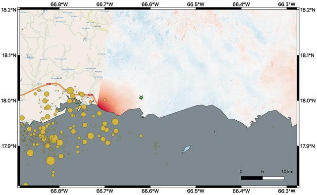
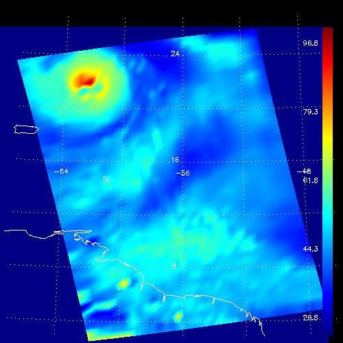
By comparing interferometric synthetic aperture radar (InSAR) data acquired on Jan. 9, 2020, with data acquired on Dec. 28, 2019, from the Copernicus Sentinel-1A satellite, NASA scientists were able to map where, how much and in what direction the ground shifted following a 6.4-magnitude earthquake off the coast of Puerto Rico. Managed by the European Space Agency (ESA), the Copernicus Sentinel-1A satellite was able to see the eastern two-thirds of the island during the Jan. 9 flyover. On the map, red indicates areas where the ground was changed, or displaced, with darker shades corresponding to more significant displacement. The scientists found that the greatest displacement from the flyover area occurred west of the city of Ponce (identified by the green star), not far from the quake's offshore epicenter. They recorded up to 5.5 inches (14 centimeters) of ground change there. The ground appeared to shift downward and slightly to the west. The epicenter of the quake and the cluster of quakes and aftershocks in the region identified by the United States Geological Survey (shown as orange circles) fall just west of the satellite's Jan. 9 track. Because of this, scientists also plan to analyze data from Sentinel-1A's forthcoming Jan. 14 flyover, which will include western Puerto Rico. https://photojournal.jpl.nasa.gov/catalog/PIA23428
The Advanced Rapid Imaging and Analysis (ARIA) team at NASA's Jet Propulsion Laboratory in Pasadena, California, and Caltech, also in Pasadena, created this Damage Proxy Map (DPM) depicting areas of Eastern Puerto Rico that are likely damaged (shown by red and yellow pixels) as a result of Hurricane Maria (a Category 4 hurricane at landfall in Puerto Rico on Sept. 20, 2017). The map is derived from synthetic aperture radar (SAR) images from the Copernicus Sentinel-1A and Sentinel-1B satellites, operated by the European Space Agency (ESA). The images were taken before (March 25, 2017) and after (Sept. 21, 2017) the storm's landfall. The map was delivered to responding agencies, including the Federal Emergency Management Agency (FEMA), on Sept. 22, 2017. FEMA combined the map with building infrastructure data to estimate a damage density map, which was sent to its Urban Search and Rescue teams in the field in Puerto Rico. The map covers an area of 105 by 60 miles (169 by 96 kilometers), shown by the large red polygon in the figure. The inset, denoted by the orange rectangle, shows the extent of damage in and around the capital city of San Juan. Each pixel measures about 98 feet (30 meters) across. The color variation from yellow to red indicates increasingly more significant ground surface change. Preliminary validation was done by comparing the map with anecdotal reports of damage. This damage proxy map should be used as guidance to identify damaged areas, and may be less reliable over vegetated and flooded areas. Sentinel-1 data were accessed through the Copernicus Open Access Hub. The image contains modified Copernicus Sentinel data (2017), processed by ESA and analyzed by the NASA-JPL/Caltech ARIA team. This research was carried out at JPL under a contract with NASA. https://photojournal.jpl.nasa.gov/catalog/PIA21964

Ingrid Padilla, Professor in Environmental and Water Resources Engineering, University of Puerto Rico, Mayaguez (UPRM) speaks on a panel at a White House Hispanic Heritage month event titled “Soaring Together: Inspiring the Next Generation of Space Leaders” at the Eisenhower Executive Office Building, Monday, Sept. 30, 2024 in Washington. Photo Credit: (NASA/Aubrey Gemignani)
From left to right, U.S. Representative Madeleine Dean, D-Pa., former astronaut and current director of NASA’s Glenn Research Center, Dr. Janet Kavandi, NASA astronaut Serena Auñón-Chancellor, U.S. resident commissioner of Puerto Rico, Jenniffer González-Colón, R-Puerto Rico, and NASA Administrator Jim Bridenstine pose for a photo just before a bipartisan Congressional Caucus for Women’s Issues briefing on NASA’s Artemis lunar exploration program, Wednesday, September 11, 2019 at the Rayburn House Office Building in Washington. Photo Credit: (NASA/Aubrey Gemignani)
This partial frame from an animation was generated using radar data collected by the National Science Foundation 1,000-foot 305-meter Arecibo Observatory in Puerto Rico.
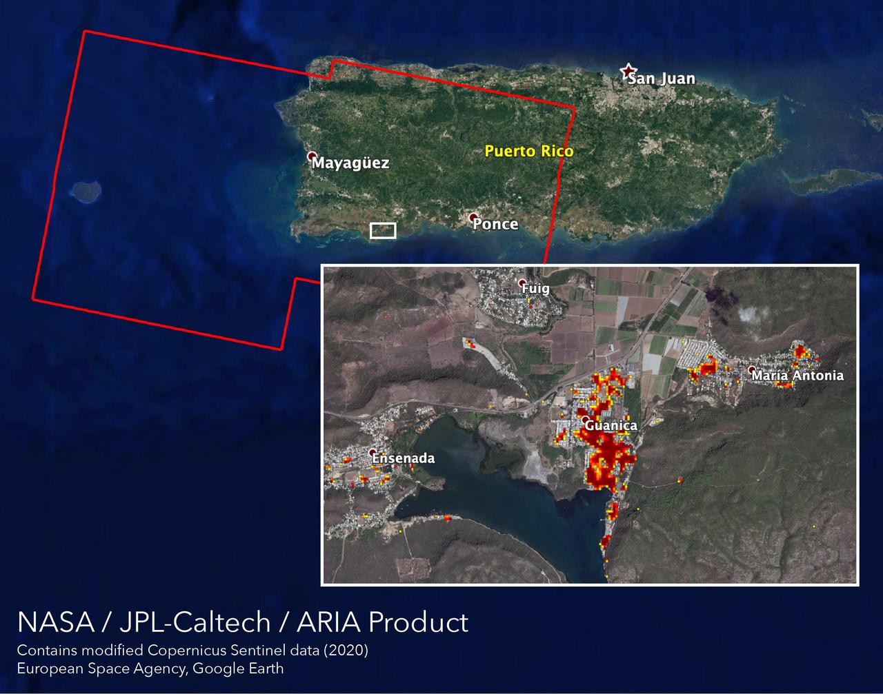
NASA scientists are helping local and federal agencies assess the extent of the damage in Puerto Rico following a 6.4-magnitude earthquake and hundreds of aftershocks. Using synthetic aperture radar data from the Copernicus Sentinel-1 satellites operated by the European Space Agency (ESA), the Advanced Rapid Imaging and Analysis (ARIA) team at NASA's Jet Propulsion Laboratory and Caltech in Pasadena, California created a new damage map that includes the southwestern coast near the main quake's epicenter. The ARIA team compared post-quake satellite data acquired on Jan. 14 with data as far back as Sept. 2019 to produce the map. The color variation from yellow to dark red indicates increasingly more significant damage. Their analysis shows that Guanica, west of the city of Ponce, was particularly hard hit. The map covers an area of 107 by 47 miles (172 by 76 kilometers), shown with the large red polygon, with each pixel measuring about 100 feet (30 meters) across. The data is most sensitive to building damage rather than small scale changes or partial structural damage. It is also less reliable over heavy vegetation. Even with these limitations, the map can still serve an important role in identifying the areas that may need help the most. The map contains modified Copernicus Sentinel data processed by ESA and analyzed by ARIA team scientists at NASA JPL and Caltech. https://photojournal.jpl.nasa.gov/catalog/PIA23429
These visualizations of Hurricane Jeanne on September 24, 2004 were captured by NASA Terra spacecraft after the hurricane caused widespread destruction on Puerto Rico, Haiti and the Dominican Republic.
This composite image was created by inserting approximately 70 orbits of NASA Magellan data into an image obtained at the Arecibo, Puerto Rico radiotelescope and shows a geologically complex region in the southern hemisphere of Venus. http://photojournal.jpl.nasa.gov/catalog/PIA00217

This artist concept depicts the pulsar planet system discovered by Aleksander Wolszczan in 1992. Wolszczan used the Arecibo radio telescope in Puerto Rico to find three planets circling a pulsar called PSR B1257+12.

Resident Commissioner of Puerto Rico, Jenniffer González-Colón, R-Puerto Rico, provides welcoming remarks at a bipartisan Congressional Caucus for Women’s Issues briefing on NASA’s Artemis lunar exploration program, Wednesday, September 11, 2019 at the Rayburn House Office Building in Washington. Photo Credit: (NASA/Aubrey Gemignani)
Resident Commissioner of Puerto Rico, Jenniffer González-Colón, R-Puerto Rico, provides opening remarks at a bipartisan Congressional Caucus for Women’s Issues briefing on NASA’s Artemis lunar exploration program, Wednesday, September 11, 2019 at the Rayburn House Office Building in Washington. Photo Credit: (NASA/Aubrey Gemignani)

During STS-31, the Hubble Space Telescope (HST) grappled by the remote manipulator system (RMS) end effector is held in appendage deploy position above Discovery, Orbiter Vehicle (OV) 103. The solar array (SA) bistem cassette has been released from its latch fittings. The bistem spreader bars begin to unfurl the SA wing. The secondary deployment mechanism (SDM) handle is visible at the SA end. Stowed against either side of the HST System Support Module (SSM) forward shell are the high-gain antennae (HGA). Puerto Rico and the Dominican Republic are recognizable at the left of the frame.

Dr. Wernher von Braun, Marshall's first Center Director (1960-1970), skin diving in Puerto Rico.

ISS044E059041 (08/21/2015) --- Hurricane Danny as seen from the International Space Station as it traversed the Caribbean Sea headed for Puerto Rico, the Dominican Republic and Cuba.

2016 LUNAR ROVER CHALLENGE HIGH SCHOOL 1ST PLACE WINNER: TEAM #6 RAFAELINA E. LEBRON FLORES FROM PUERTO RICO.
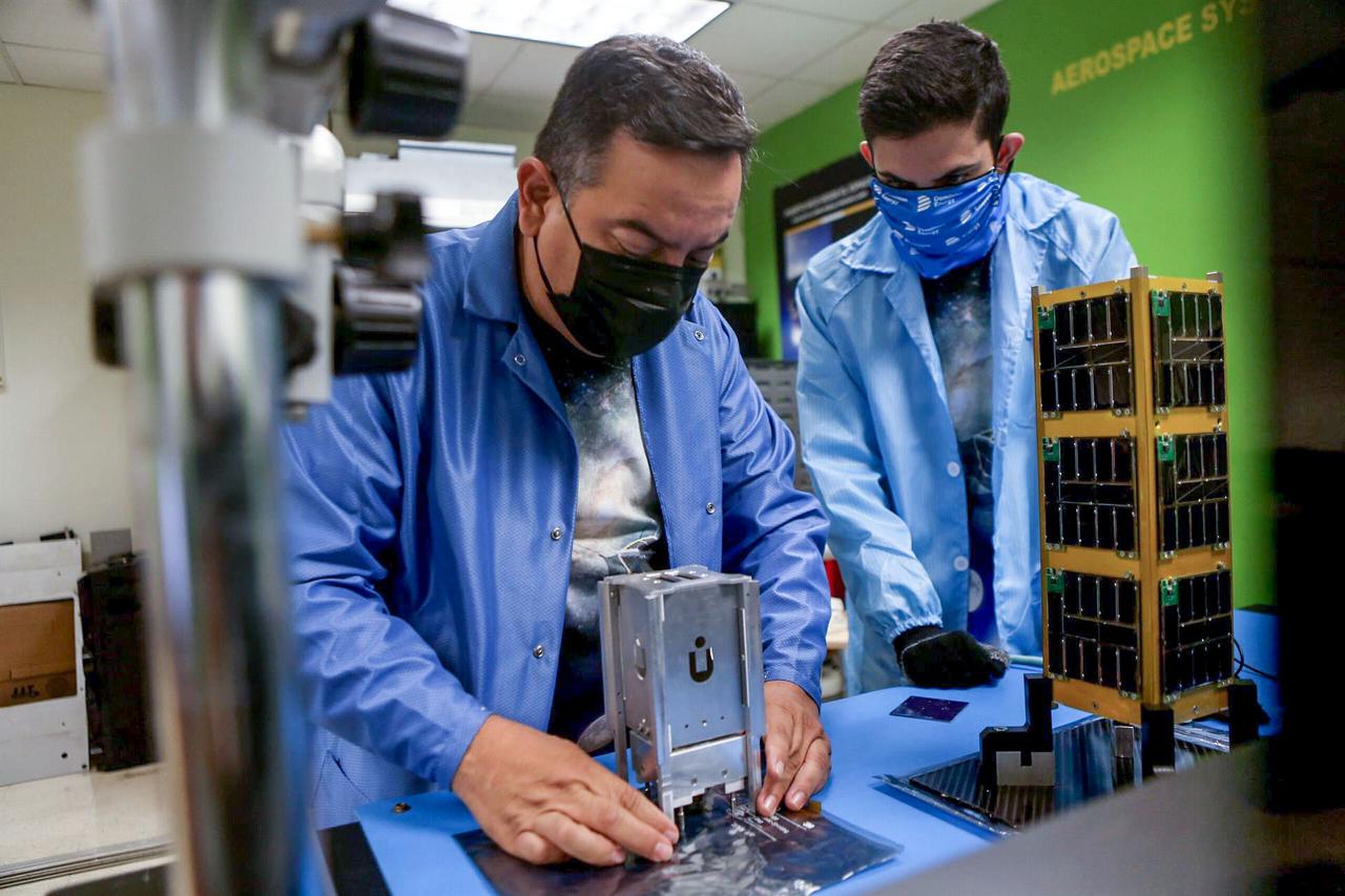
jsc2021e037903 (8/24/2021) --- Dr. Amilcar Rincon-Charris and Edwardivan Labarca-Torres working with the integration of the PRCuNaR2 payload. The Puerto Rico CubeSat NanoRocks 2 (PR-CuNaR2) is an educational and scientific microsatellite that seeks to increase understanding of the outcomes of relevant collisions among millimeter-sized particles, or “pebbles”, in a protoplanetary disk. Image courtesy of Inter-American University of Puerto Rico.
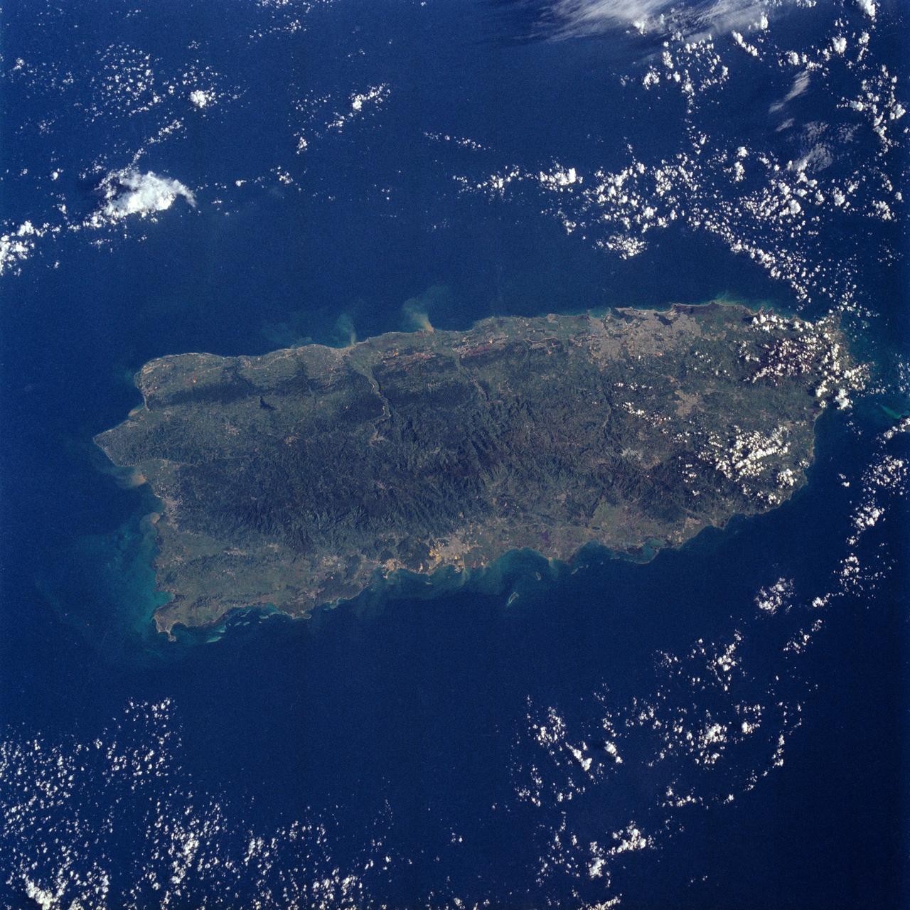
STS034-76-088 (18-23 Oct. 1989) --- A nearly vertical view over the island of Puerto Rico. NASA photo experts believe this to be an excellent view of Puerto Rico, because it has no cloud cover and the island is captured in its entirety. A 70mm handheld aimed through the space shuttle Atlantis' aft windows was used to expose the frame. Center point of the frame is 18.0 degrees north latitude and 66.5 degrees west longitude.
From left to right, Director of NASA’s Glenn Research Center, Dr. Janet Kavandi, Representative Debbie Lesko, R-Ariz., NASA astronaut Serena Auñón-Chancellor, and Resident Commissioner of Puerto Rico, Jenniffer González-Colón, R-Puerto Rico, speak to each other at the conclusion of a bipartisan Congressional Caucus for Women’s Issues briefing on NASA’s Artemis lunar exploration program, Wednesday, September 11, 2019 at the Rayburn House Office Building in Washington. Photo Credit: (NASA/Aubrey Gemignani)
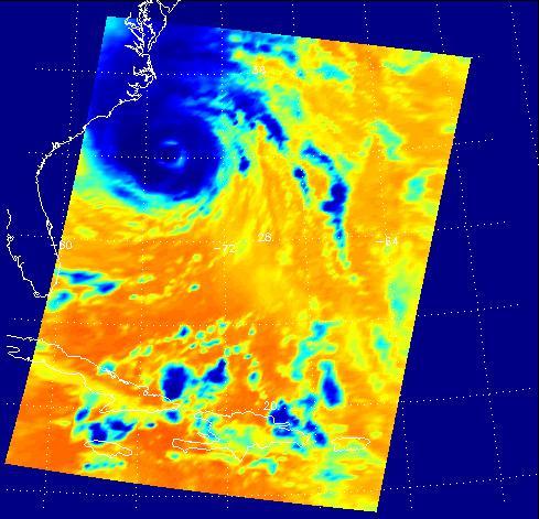
NASA Aqua spacecraft continues to track the gradual organization of Tropical Storm Emily, as seen in this image taken Aug. 2, 2011 at 1:05 p.m. EDT. At that time, the storm was located about 270 miles southeast of San Juan, Puerto Rico.
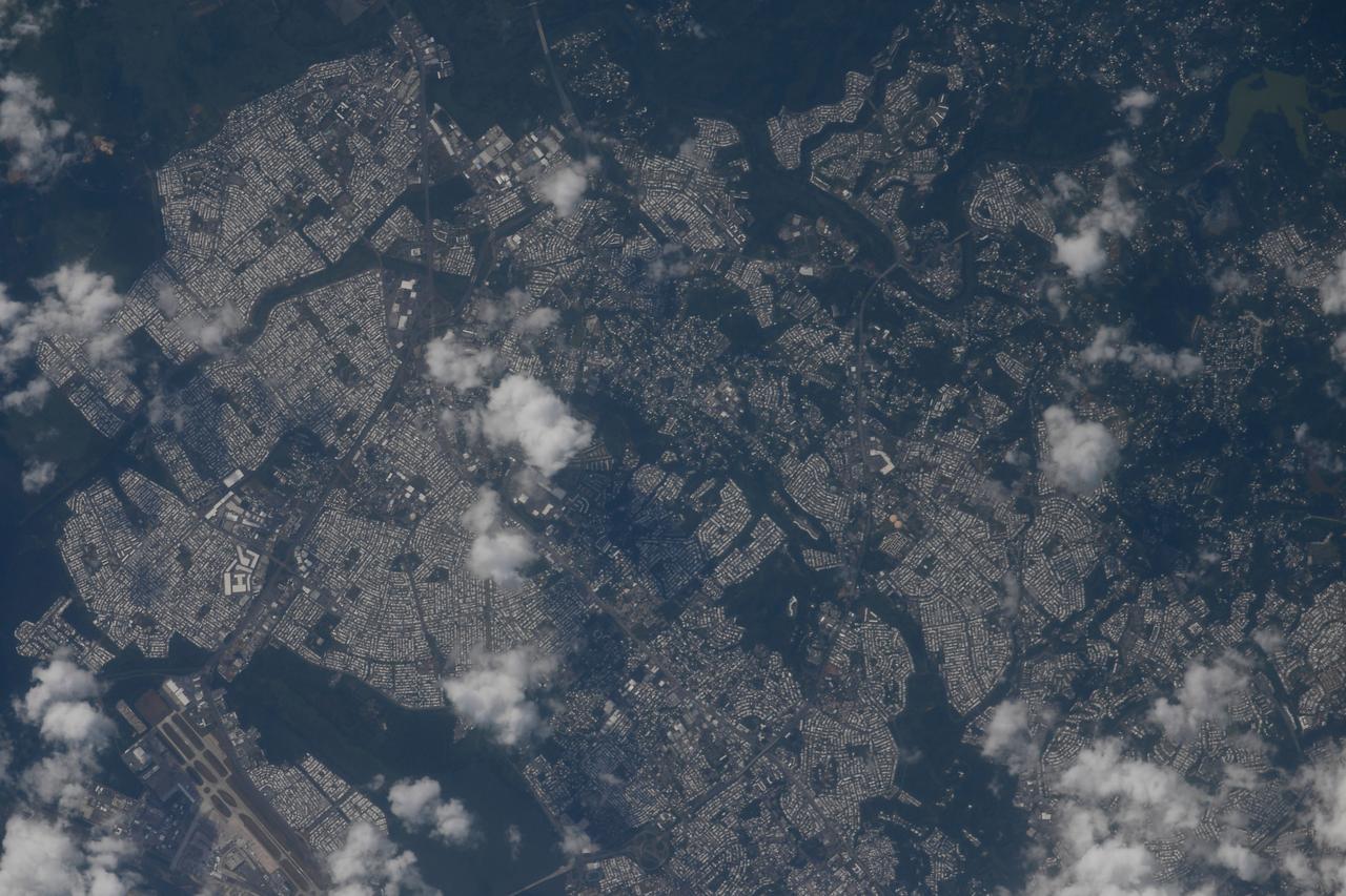
iss063e009535 (May 7, 2020) --- The city of San Juan, Puerto Rico, and surrounding municipalities are pictured from the International Space Station as it orbited off the Atlantic coast of the U.S. territory. Credit: Roscosmos

jsc2021e037904 (8/24/2021) --- Group photo of the PRCuNaR2 development team. From top left to right, Hector Gonzalez, Carlos Gibson, Lucas Soto, Amilcar Rincon, Xavier Alvarez, Ian Ortiz and Jesus Marrero. From bottom left to right, Edwardivan Labarca, Natalie Cruz and Carlos Vergara. The Puerto Rico CubeSat NanoRocks 2 (PR-CuNaR2) is an educational and scientific microsatellite that seeks to increase understanding of the outcomes of relevant collisions among millimeter-sized particles, or “pebbles”, in a protoplanetary disk. Image courtesy of Inter-American University of Puerto Rico.
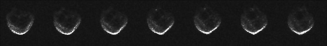
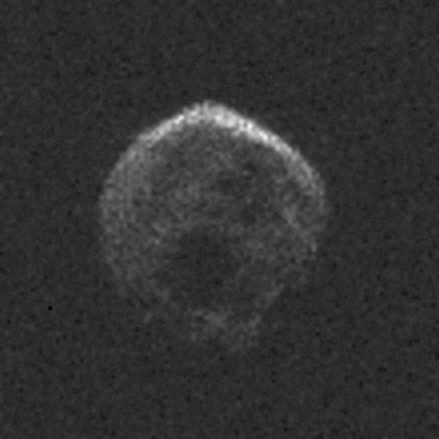
These first radar images of 2015 TB145 from the National Science Foundation 1,000-foot 305-meter Arecibo Observatory in Puerto Rico, indicate the near-Earth object is spherical in shape and approximately 2,000 feet 600 meters in diameter. The radar images were taken on Oct. 30, 2015, and the image resolution is 25 feet (7.5 meters) per pixel. The celestial object is more than likely a dead comet that has shed its volatiles after numerous passes around the sun. http://photojournal.jpl.nasa.gov/catalog/PIA20040

iss054e012391 (Jan. 1, 2018) --- Despite the cloudiness during this nighttime photograph taken by Expedition 54 crew members aboard the International Space Station, the Caribbean islands of (from top left to bottom right) Puerto Rico, Cuba, Haiti and the Dominican Republic are seen from an altitude of 250 miles.
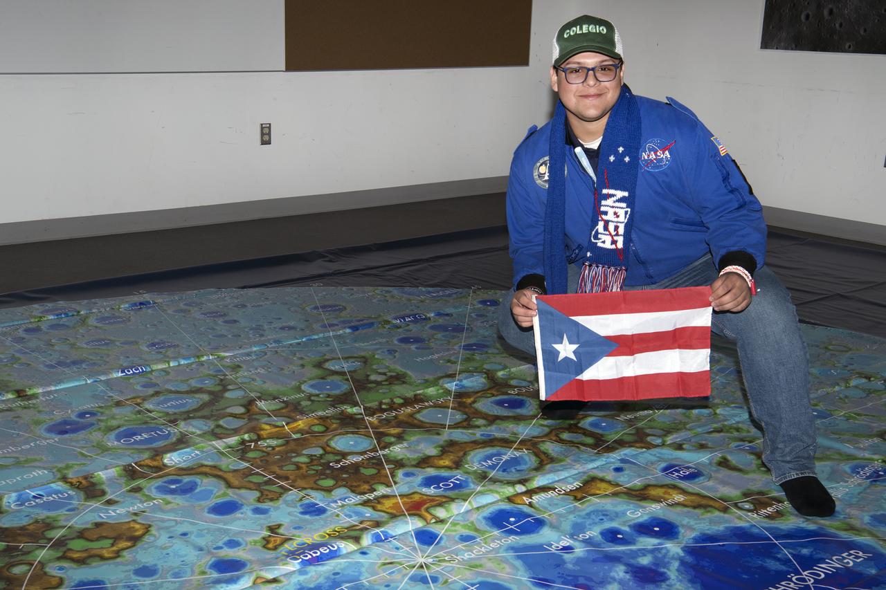
Social media followers visited GSFC Feb 10, 2020 learning role of Artemis, LRO Lunar Reconnaisssance Orbiter, and spoke with science experts while touring center Here student holds Puerto Rico flag over map
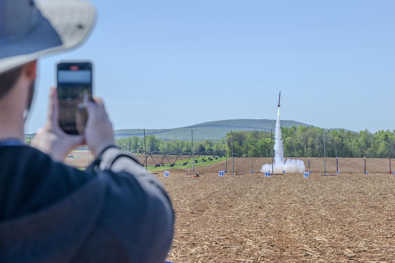
Over 1,000 middle school, high school, and collegiate students from across the U.S. and Puerto Rico launched high-powered, amateur rockets on April 13, just north of NASA’s Marshall Space Flight Center in Huntsville, Alabama, as part of the agency’s annual Student Launch rocketry competition.
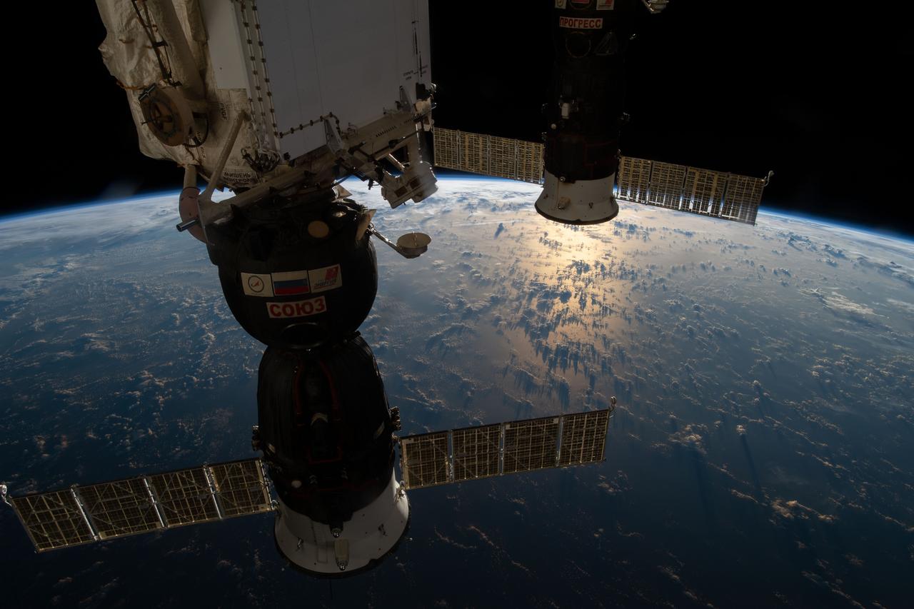
iss059e102792 (June 12, 2019) --- Two docked Russian spaceships, the Soyuz MS-12 crew ship (foreground) and the Progress 72 resupply ship, are pictured as the International Space Station orbited 258 miles above the Atlantic Ocean northeast of Puerto Rico.
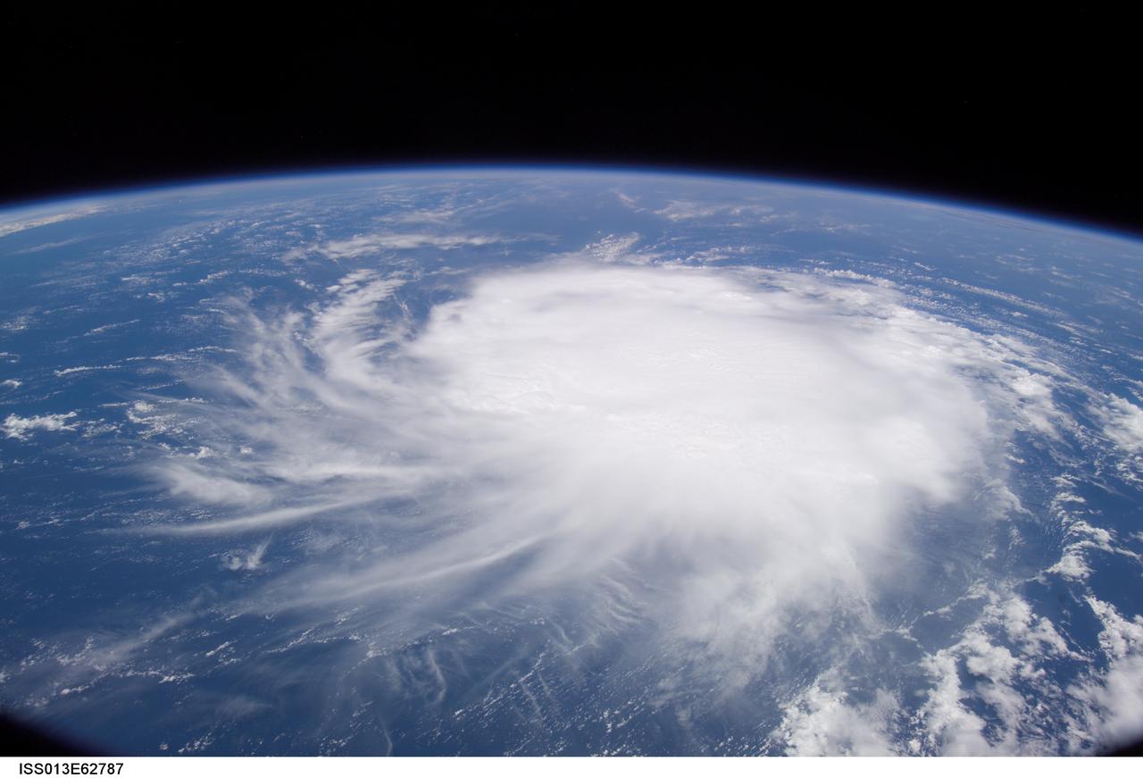
ISS013-E-62787 (2 August 2006) --- Tropical Storm Chris was located to the east of Puerto Rico and the Leeward Islands at at 9:29 a.m. (CDT), August 2, when one of the members of the Expedition 13 crew recorded this digital still image.

ISS006-E-16953 (9 January 2003) --- The Space Station Remote Manipulator System (SSRMS) or Canadarm2 is backdropped against the Caribbean Sea in this digital still camera's view taken from the International Space Station (ISS). Puerto Rico is in the left side of the frame.

iss055e023899 (April 15, 2018) --- The United States island territory of Puerto Rico and the surrounding blue waters of the Caribbean Sea on its southern coast and the Atlantic Ocean on its northern coast were pictured by an Expedition 55 crew member aboard the International Space Station.
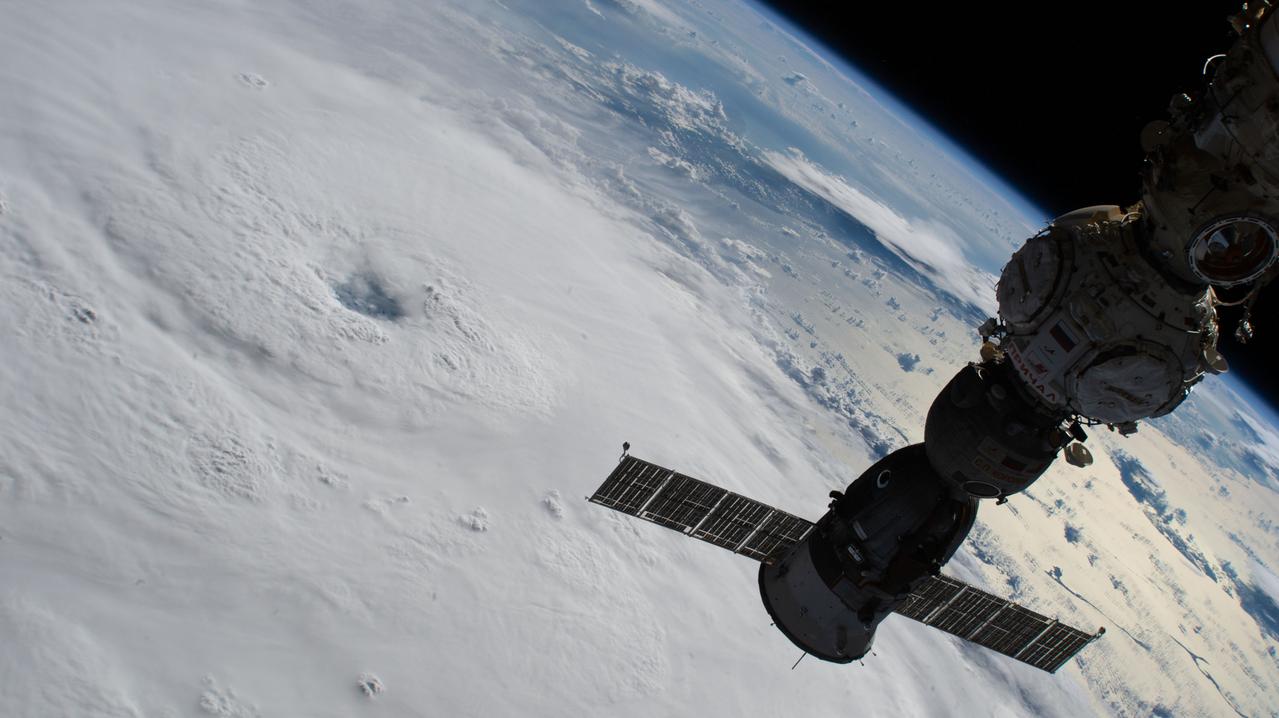
iss067e375885 (Sept. 20, 2022) --- Hurricane Fiona is pictured from the International Space Station as it orbited 259 miles above the Atlantic Ocean north of Puerto Rico. In the foreground, the Soyuz MS-22 crew ship docked to the Prichal module is silhouetted above the storm.

STS069-715-019 (15 September 1995) --- This photograph of Hurricane Marilyn was captured on film as it moves over Puerto Rico, in this 70mm frame. The southern half of Puerto Rico can be seen outside the cloud cover. The island of Hispaniola is seen in lower left-hand corner. During the 11-plus day mission, the astronauts aboard the Space Shuttle Endeavour caught with their cameras at least two large oceanic storms. Another hurricane, named Luis, followed a similar path earlier in the flight. Endeavour, with a five-member crew, launched on September 7, 1995, from the Kennedy Space Center (KSC) and ended its mission there September 18, 1995, with a successful landing on Runway 33. The multifaceted mission carried the crew of astronauts David M. Walker, mission commander; Kenneth D. Cockrell, pilot; and James S. Voss (payload commander), James H. Newman, Michael L. Gernhardt, all mission specialists.
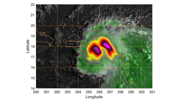
TEMPEST-D — a weather-observing satellite the size of a cereal box — captured imagery of Hurricane Dorian off the coast of Puerto Rico in the early morning hours (local time) of Aug. 28, 2019. At a vantage point 250 miles (400 kilometers) above the storm, the CubeSat used its miniaturized radio-wave-based instrument to see through the clouds, revealing areas with strong rain and moisture being pulled into the storm. The green colors show moisture spiraling into the storm's center, and the yellow to pink colors correspond to the most intense rainfall. TEMPEST-D — short for Temporal Experiment for Storms and Tropical Systems Demonstration — is an experiment in shrinking weather satellites to a size that makes them inexpensive enough to produce in multiples. The goal is eventual real-time storm coverage with many small satellites that can track storms around the world. https://photojournal.jpl.nasa.gov/catalog/PIA23414

Resident Commissioner Jenniffer González-Colón, R-Puerto Rico, asks NASA Administrator Jim Bridenstine a question during a House Committee on Science, Space, and Technology hearing to review the Fiscal Year 2020 budget request for the National Aeronautics and Space Administration, Tuesday, April 2, 2019 at the Rayburn House Office Building in Washington. Photo Credit: (NASA/Aubrey Gemignani)
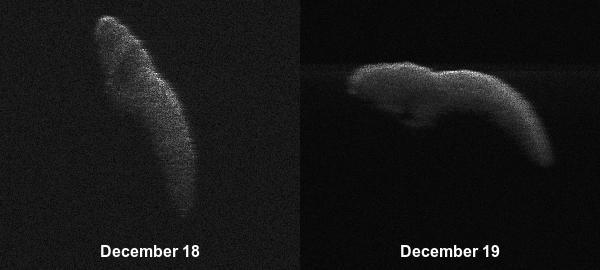
These two radar images of near-Earth asteroid 2003 SD220 were obtained on Dec. 18 and 19 by coordinating observations with the Arecibo Observatory's 1,000-foot (305-meter) antenna in Puerto Rico and the National Science Foundation's (NSF) 330-foot (100-meter) Green Bank Telescope in West Virginia. The radar images reveal the asteroid is at least one mile (1.6 kilometers) long. https://photojournal.jpl.nasa.gov/catalog/PIA22969
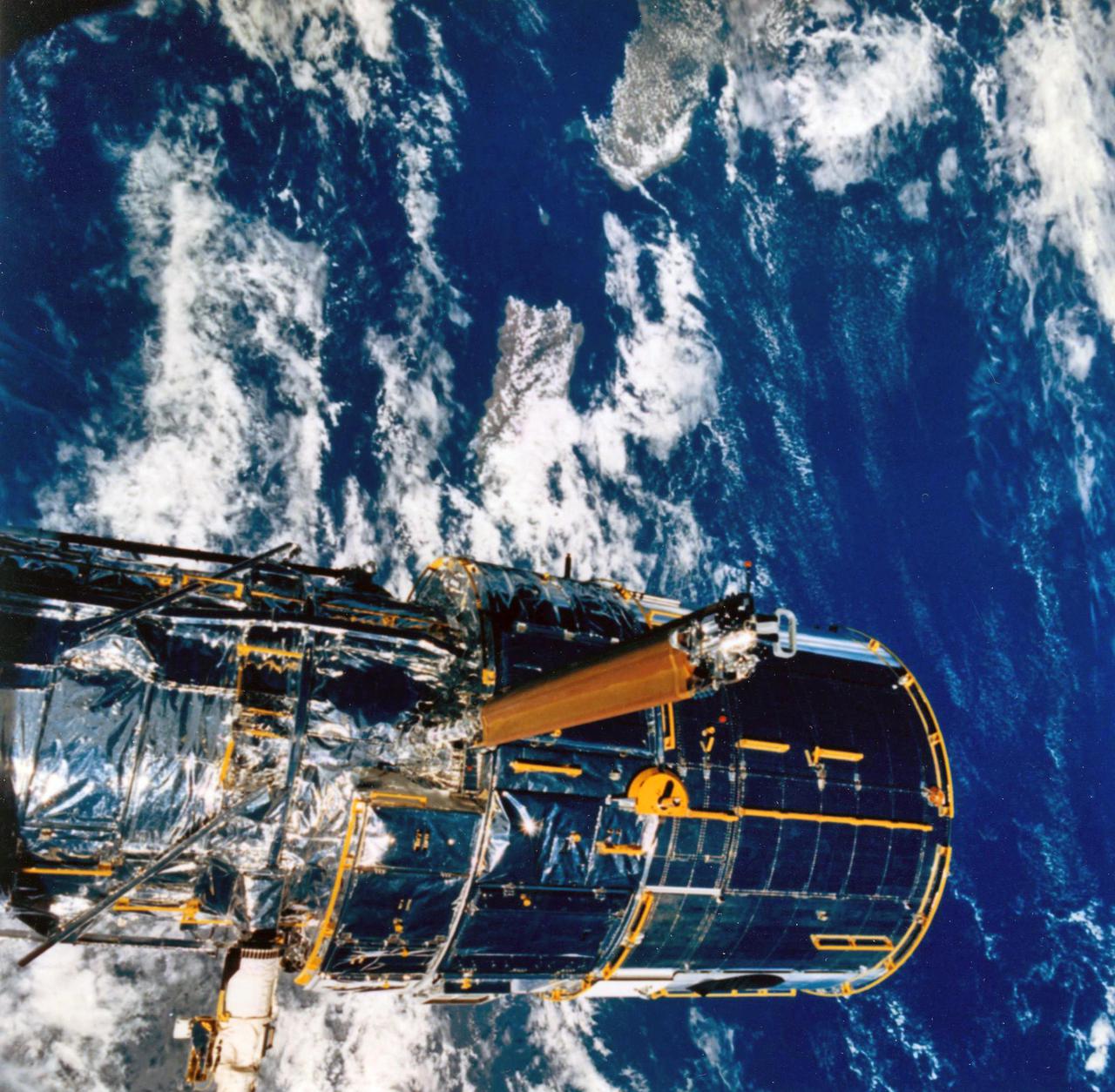
JOHNSON SPACE CENTER, HOUSTON, TEXAS-- STS-31 ONBOARD SCENE -- The Hubble Space Telescope (HST) is suspended in space by Discovery's remote manipulator system prior to deployment of its solar array panels and antennae and its ultimate release. Puerto Rico and the Dominican Republic are recognizable at left of the frame. The photo was taken with a handheld Hasselblad camera. This was among the first photos NASA released on April 30 from the five-day mission.

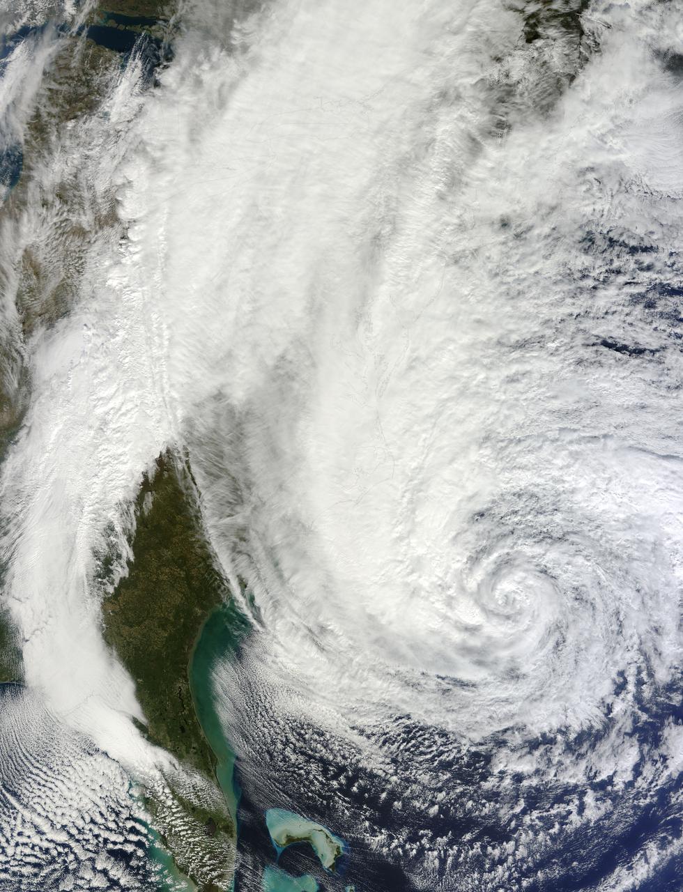
ISS028-E-028782 (22 Aug. 2011) --- This panoramic view of recently-formed Hurricane Irene was acquired by the crew of the International Space Station early Monday afternoon from a point over the coastal waters of Venezuela. At the time Irene was packing winds of 80mph and was just north of the Mona Passage between Hispaniola and Puerto Rico. Although no eye was visible at this time, the storm was strengthening and exhibited the size and structure of a classic ?Cape Verde? hurricane as it tracked west-northwestward towards the southern Bahamas.

AS08-16-2581 (21-27 Dec. 1968) --- This photograph of Earth was taken from the Apollo 8 spacecraft while it was in Earth orbit. Most of the southeastern United States and the Caribbean Sea area, the U.S. coastline from Chesapeake Bay to the Florida Peninsula can be seen. The Bahamas and the islands of Cuba, Jamaica, Hispaniola and Puerto Rico extend across the Caribbean, the light blue of the shallow Bahama banks contrasting sharply with the darker hue of the deeper water, especially in the Tongue of the Ocean area.
iss073e0854494 (Sept. 21, 2025) --- The coastlines of Colombia and Venezuela (left), illuminated by city lights, are separated from the island nations of the Dominican Republic and Puerto Rico (far right) by the dark expanse of the Caribbean Sea. The International Space Station was orbiting approximately 260 miles above Earth when this photograph was taken at around 1:06 a.m. local time.
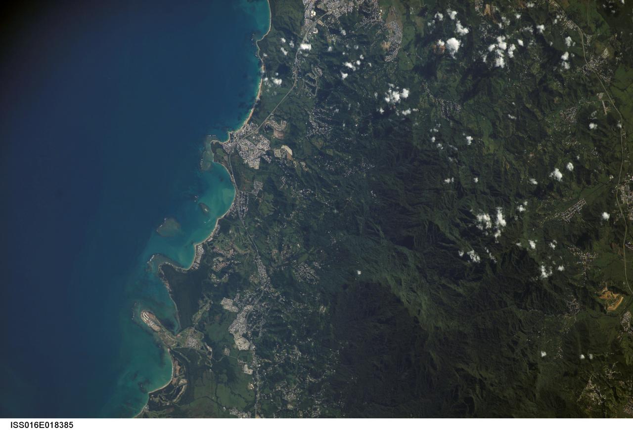
ISS016-E-018385 (23 Dec. 2008) --- Luquillo Mountains, Puerto Rico are featured in this image photographed by an Expedition 16 crewmember on the International Space Station. The Luquillo Mountains are located in the northeastern portion of Puerto Rico and rise to elevations of 1,075 meters. According to scientists, the mountains are comprised mainly of volcanic rock material that was uplifted by tectonism - Puerto Rico is located between the junction of the North American and Caribbean plates - approximately 37--28 million years ago. Prevailing easterly winds bring moisture from the Caribbean Sea that falls as precipitation as they cross the mountains. Higher elevations receive more rainfall than lower elevations, leading to subtropical forest types in the lowlands and montane forest types near the summits. This image, taken during the rainy season, illustrates the rich vegetation cover of the mountains. The rapid change in ecosystems with elevation, land use history, and exposure to frequent natural disturbances (such as hurricanes) makes the Luquillo Mountains as ideal location for ecological study. The Luquillo Experimental Forest Long Term Ecological Research (LTER) site is contained within the Luquillo National Forest, covering much of the mountains to the southwest of the city of Luquillo (center). Historical human land uses in the Forest -- such as logging, agriculture, charcoal production, and coffee plantations - have determined much of the current ecosystem structure. Results of LTER site research indicates that the forest ecosystems recover more rapidly from natural disturbances (like hurricanes) than they do from human disturbance.
Students from across the United States and as far away as Puerto Rico and South America came to Huntsville, Alabama for the 9th annual Great Moonbuggy Race at the U.S. Space Rocket Center. Seventy-seven teams, representing high schools and colleges from 21 states, Puerto Rico, and Columbia, raced human powered vehicles over a lunar-like terrain. In this photograph, the New Orleans area schools team #2 from New Orleans, Louisiana maneuvers through an obstacle course. The team captured second place in the high school division competition. Vehicles powered by two team members, one male and one female, raced one at a time over a half-mile obstacle course of simulated moonscape terrain. The competition is inspired by the development, some 30 years ago, of the Lunar Roving Vehicle (LRV), a program managed by the Marshall Space Flight Center. The LRV team had to design a compact, lightweight, all-terrain vehicle that could be transported to the Moon in the small Apollo spacecraft. The Great Moonbuggy Race challenges students to design and build a human powered vehicle so they will learn how to deal with real-world engineering problems, similar to those faced by the actual NASA LRV team.

Students from across the United States and as far away as Puerto Rico and South America came to Huntsville, Alabama for the 9th annual Great Moonbuggy Race at the U.S. Space Rocket Center. Seventy-seven teams, representing high schools and colleges from 21 states, Puerto Rico, and Columbia, raced human powered vehicles over a lunar-like terrain. A team from Cornell University in Ithaca, New York, took the first place honor in the college division. In this photograph, the Cornell #1 team, the collegiate first place winner, maneuvers their vehicle through the course. Vehicles powered by two team members, one male and one female, raced one at a time over a half-mile obstacle course of simulated moonscape terrain. The competition is inspired by development, some 30 years ago, of the Lunar Roving Vehicle (LRV), a program managed by the Marshall Space Flight Center. The LRV team had to design a compact, lightweight, all-terrain vehicle that could be transported to the Moon in the small Apollo spacecraft. The Great Moonbuggy Race challenges students to design and build a humanpowered vehicle so they will learn how to deal with real-world engineering problems similar to those faced by the actual NASA LRV team.

Students from across the United States and as far away as Puerto Rico and South America came to Huntsville, Alabama for the 9th annual Great Moonbuggy Race at the U.S. Space Rocket Center. Seventy-seven teams, representing high schools and colleges from 21 states, Puerto Rico, and Columbia, raced human powered vehicles over a lunar-like terrain. A team from Cornell University in Ithaca, New York, took the first place honor in the college division. This photograph shows the Cornell #2 team driving their vehicle through the course. The team finished the race in second place in the college division. Vehicles powered by two team members, one male and one female, raced one at a time over a half-mile obstacle course of simulated moonscape terrain. The competition is inspired by development, some 30 years ago, of the Lunar Roving Vehicle (LRV), a program managed by the Marshall Space Flight Center. The LRV team had to design a compact, lightweight, all-terrain vehicle, that could be transported to the Moon in the small Apollo spacecraft. The Great Moonbuggy Race challenges students to design and build a human powered vehicle so they will learn how to deal with real-world engineering problems, similar to those faced by the actual NASA LRV team.
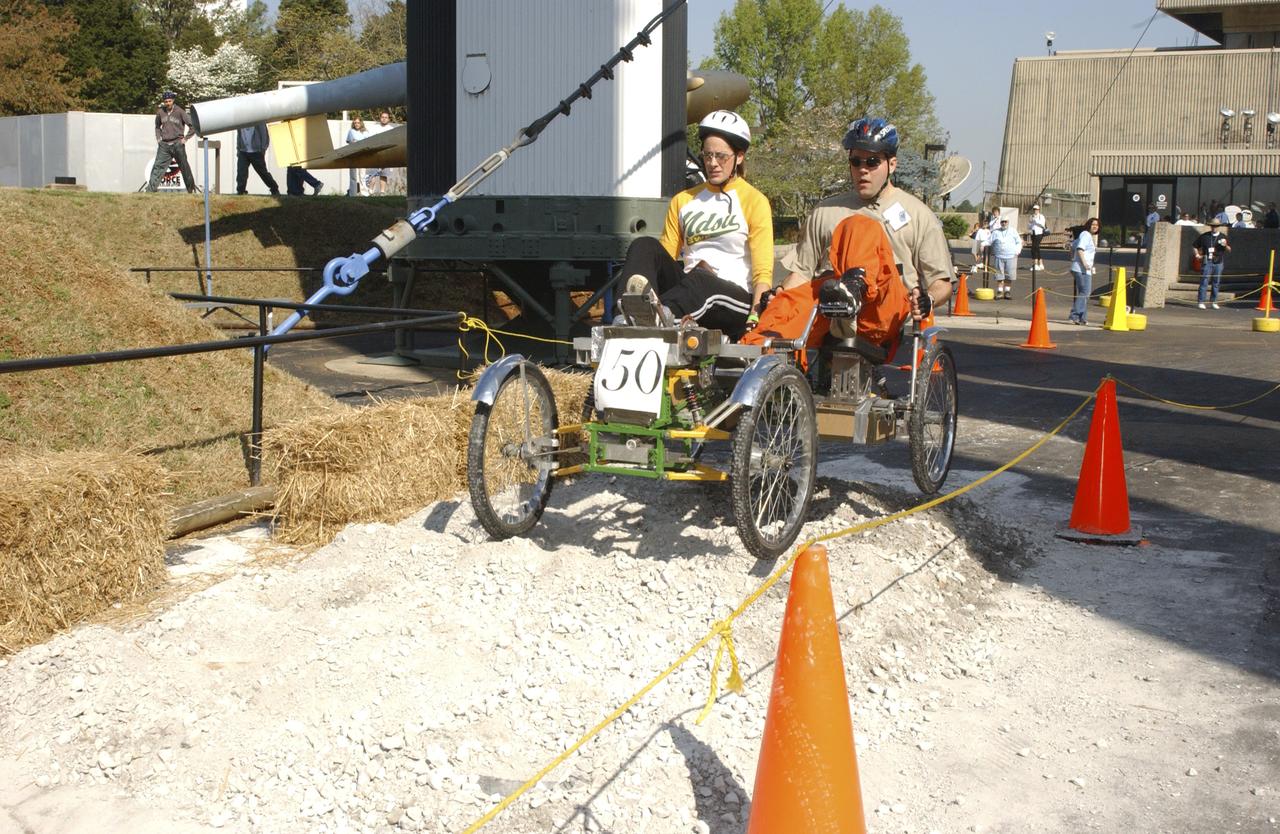
Students from across the United States and as far away as Puerto Rico came to Huntsville, Alabama for the 10th annual Great Moonbuggy Race at the U.S. Space Rocket Center. Sixty-eight teams, representing high schools and colleges from all over the United States, and Puerto Rico, raced human powered vehicles over a lunar-like terrain. Vehicles powered by two team members, one male and one female, raced one at a time over a half-mile obstacle course of simulated moonscape terrain. The competition is inspired by development, some 30 years ago, of the Lunar Roving Vehicle (LRV), a program managed by the Marshall Space Flight Center. The LRV team had to design a compact, lightweight, all-terrain vehicle that could be transported to the Moon in the small Apollo spacecraft. The Great Moonbuggy Race challenges students to design and build a human powered vehicle so they will learn how to deal with real-world engineering problems similar to those faced by the actual NASA LRV team. In this photograph, Team No. 1 from North Dakota State University in Fargo conquers one of several obstacles on their way to victory. The team captured first place honors in the college level competition.

From left to right, moderator Trina Espinoza, Science Communicator, Hispanic Heritage Foundation, Ingrid Padilla, Professor in Environmental and Water Resources Engineering, University of Puerto Rico, Mayaguez (UPRM), Frank Avila, Deputy Director, Source Operations, National Geospatial-Intelligence Agency (NGA), and Diana Trujillo, NASA Human Spaceflight Director, speak on a panel at a White House Hispanic Heritage month event titled “Soaring Together: Inspiring the Next Generation of Space Leaders” at the Eisenhower Executive Office Building, Monday, Sept. 30, 2024 in Washington. Photo Credit: (NASA/Aubrey Gemignani)

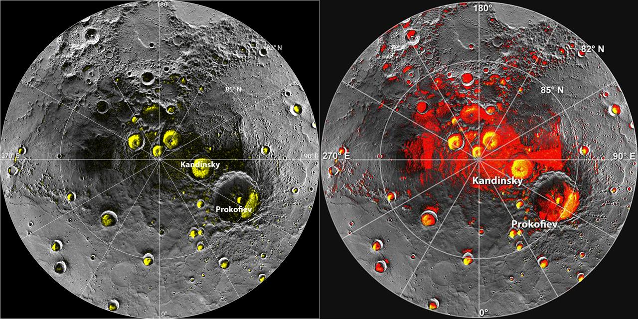
This orthographic projection view from NASA MESSENGER spacecraft provides a look at Mercury north polar region. The yellow regions in many of the craters mark locations that show evidence for water ice, as detected by Earth-based radar observations from Arecibo Observatory in Puerto Rico. MESSENGER has collected compelling new evidence that the deposits are indeed water ice, including imaging within the permanently shaded interiors of some of the craters, such as Prokofiev and Fuller. Instrument: Mercury Dual Imaging System (MDIS) Arecibo Radar Image: In yellow (Harmon et al., 2011, Icarus 211, 37-50) http://photojournal.jpl.nasa.gov/catalog/PIA19411

Diana Trujillo, NASA Human Spaceflight Director, right, speaks on a panel with, from left to right, moderator Trina Espinoza, Science Communicator, Hispanic Heritage Foundation, Ingrid Padilla, Professor in Environmental and Water Resources Engineering, University of Puerto Rico, Mayaguez (UPRM), and Frank Avila, Deputy Director, Source Operations, National Geospatial-Intelligence Agency (NGA), at a White House Hispanic Heritage month event titled “Soaring Together: Inspiring the Next Generation of Space Leaders” at the Eisenhower Executive Office Building, Monday, Sept. 30, 2024 in Washington. Photo Credit: (NASA/Aubrey Gemignani)

Diana Trujillo, NASA Human Spaceflight Director, right, speaks on a panel with, from left to right, moderator Trina Espinoza, Science Communicator, Hispanic Heritage Foundation, Ingrid Padilla, Professor in Environmental and Water Resources Engineering, University of Puerto Rico, Mayaguez (UPRM), and Frank Avila, Deputy Director, Source Operations, National Geospatial-Intelligence Agency (NGA), at a White House Hispanic Heritage month event titled “Soaring Together: Inspiring the Next Generation of Space Leaders” at the Eisenhower Executive Office Building, Monday, Sept. 30, 2024 in Washington. Photo Credit: (NASA/Aubrey Gemignani)

Diana Trujillo, NASA Human Spaceflight Director, speaks on a panel with, from left to right, moderator Trina Espinoza, Science Communicator, Hispanic Heritage Foundation, Ingrid Padilla, Professor in Environmental and Water Resources Engineering, University of Puerto Rico, Mayaguez (UPRM), and Frank Avila, Deputy Director, Source Operations, National Geospatial-Intelligence Agency (NGA), at a White House Hispanic Heritage month event titled “Soaring Together: Inspiring the Next Generation of Space Leaders” at the Eisenhower Executive Office Building, Monday, Sept. 30, 2024 in Washington. Photo Credit: (NASA/Aubrey Gemignani)
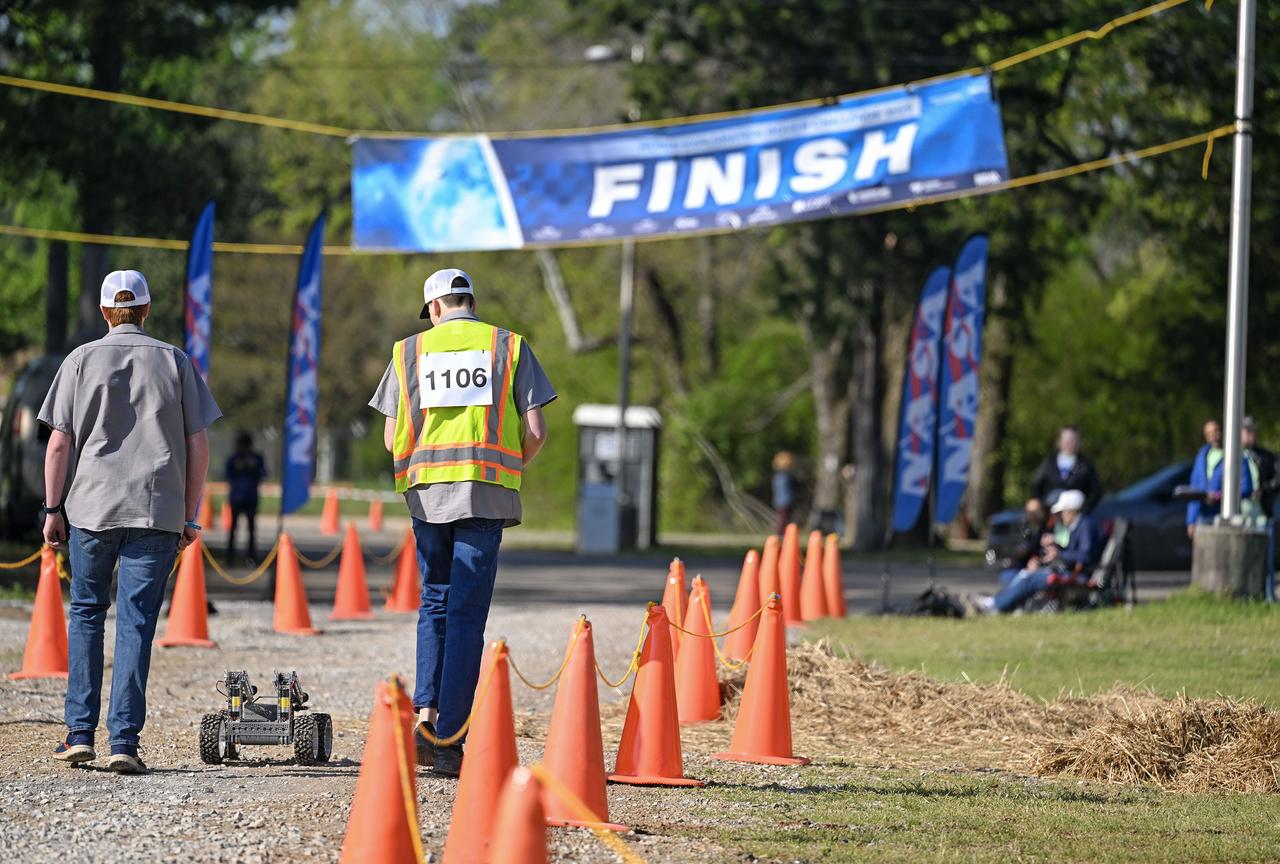
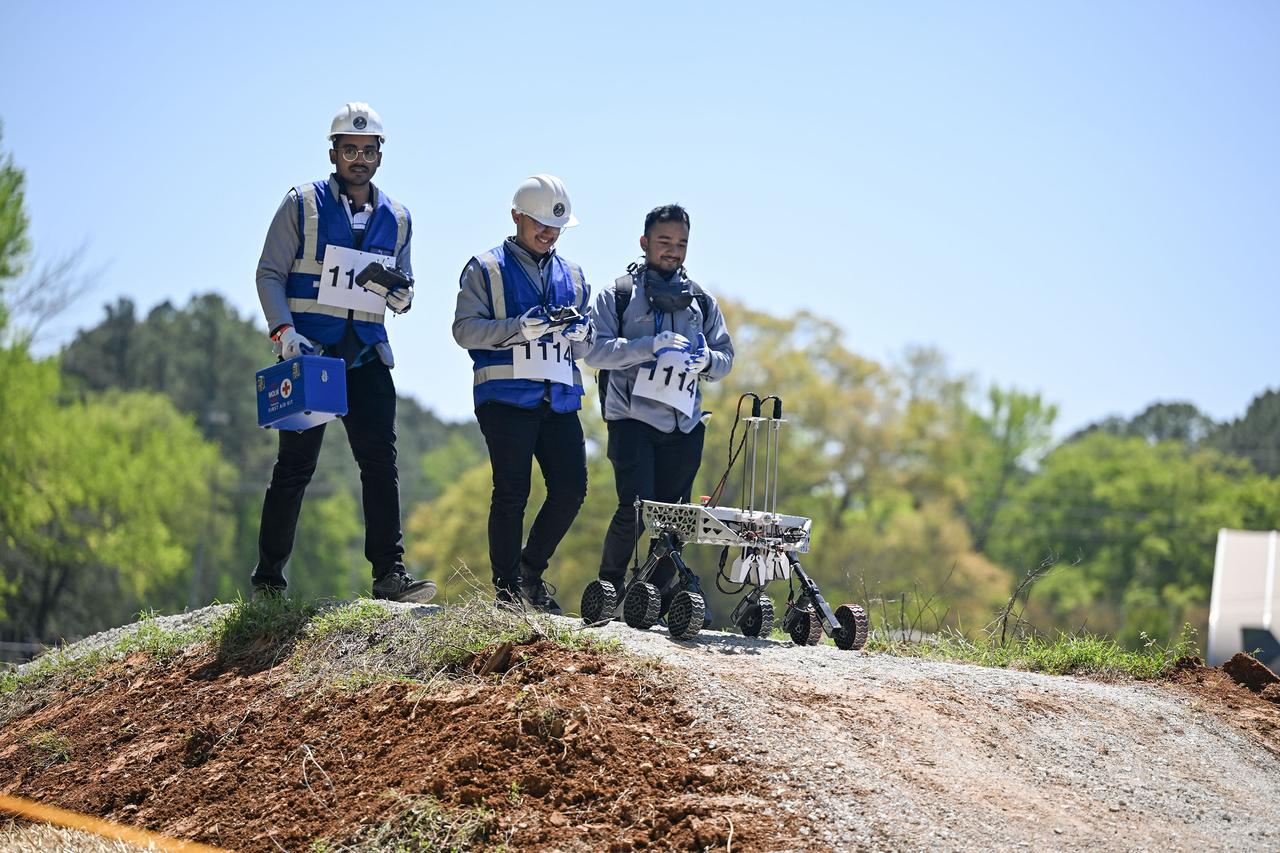
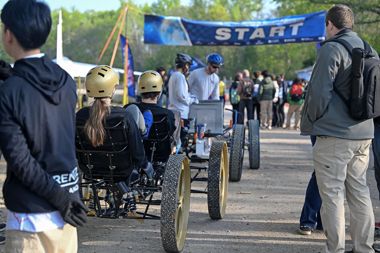
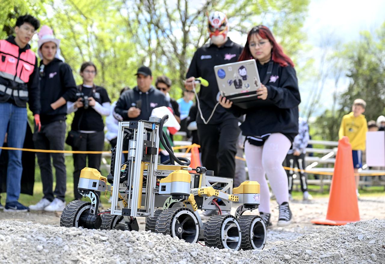
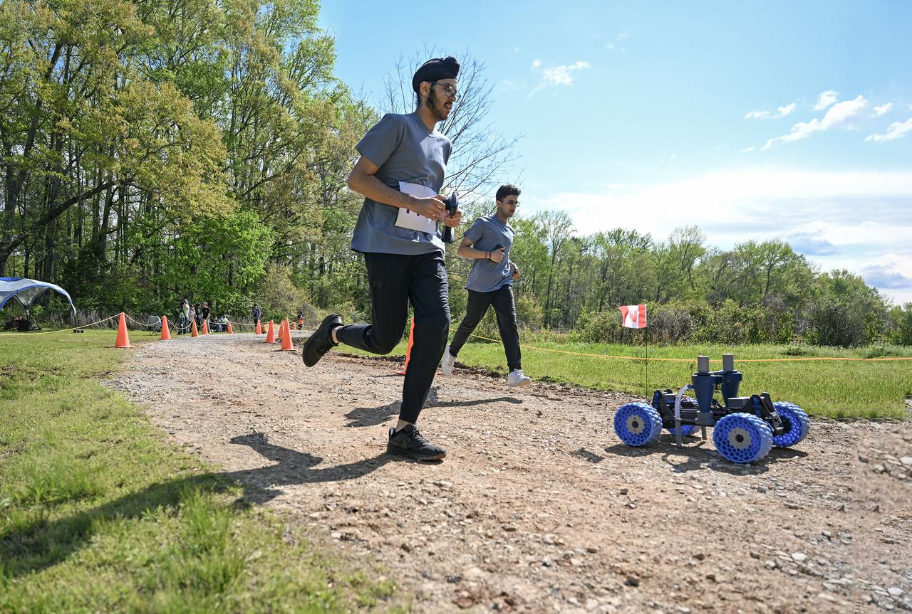
More than 500 students with 75 teams from around the world participated in the 31st year of NASA’s Human Exploration Rover Challenge (HERC) on April 11 and April 12, 2025, near NASA’s Marshall Space Flight Center in Huntsville, Alabama. Participating teams represented 35 colleges and universities, 38 high schools, and two middle schools from 20 states, Puerto Rico, and 16 other nations. NASA expanded the 2025 challenge to include a remote-control division - named Remote-Operated Vehicular Research - and invited middle school students to participate. Teams were awarded points based on navigating a half-mile obstacle course, conducting mission-specific task challenges, and completing multiple safety and design reviews with NASA engineers.

More than 500 students with 75 teams from around the world participated in the 31st year of NASA’s Human Exploration Rover Challenge (HERC) on April 11 and April 12, 2025, near NASA’s Marshall Space Flight Center in Huntsville, Alabama. Participating teams represented 35 colleges and universities, 38 high schools, and two middle schools from 20 states, Puerto Rico, and 16 other nations. NASA expanded the 2025 challenge to include a remote-control division - named Remote-Operated Vehicular Research - and invited middle school students to participate. Teams were awarded points based on navigating a half-mile obstacle course, conducting mission-specific task challenges, and completing multiple safety and design reviews with NASA engineers.

More than 500 students with 75 teams from around the world participated in the 31st year of NASA’s Human Exploration Rover Challenge (HERC) on April 11 and April 12, 2025, near NASA’s Marshall Space Flight Center in Huntsville, Alabama. Participating teams represented 35 colleges and universities, 38 high schools, and two middle schools from 20 states, Puerto Rico, and 16 other nations. NASA expanded the 2025 challenge to include a remote-control division - named Remote-Operated Vehicular Research - and invited middle school students to participate. Teams were awarded points based on navigating a half-mile obstacle course, conducting mission-specific task challenges, and completing multiple safety and design reviews with NASA engineers.
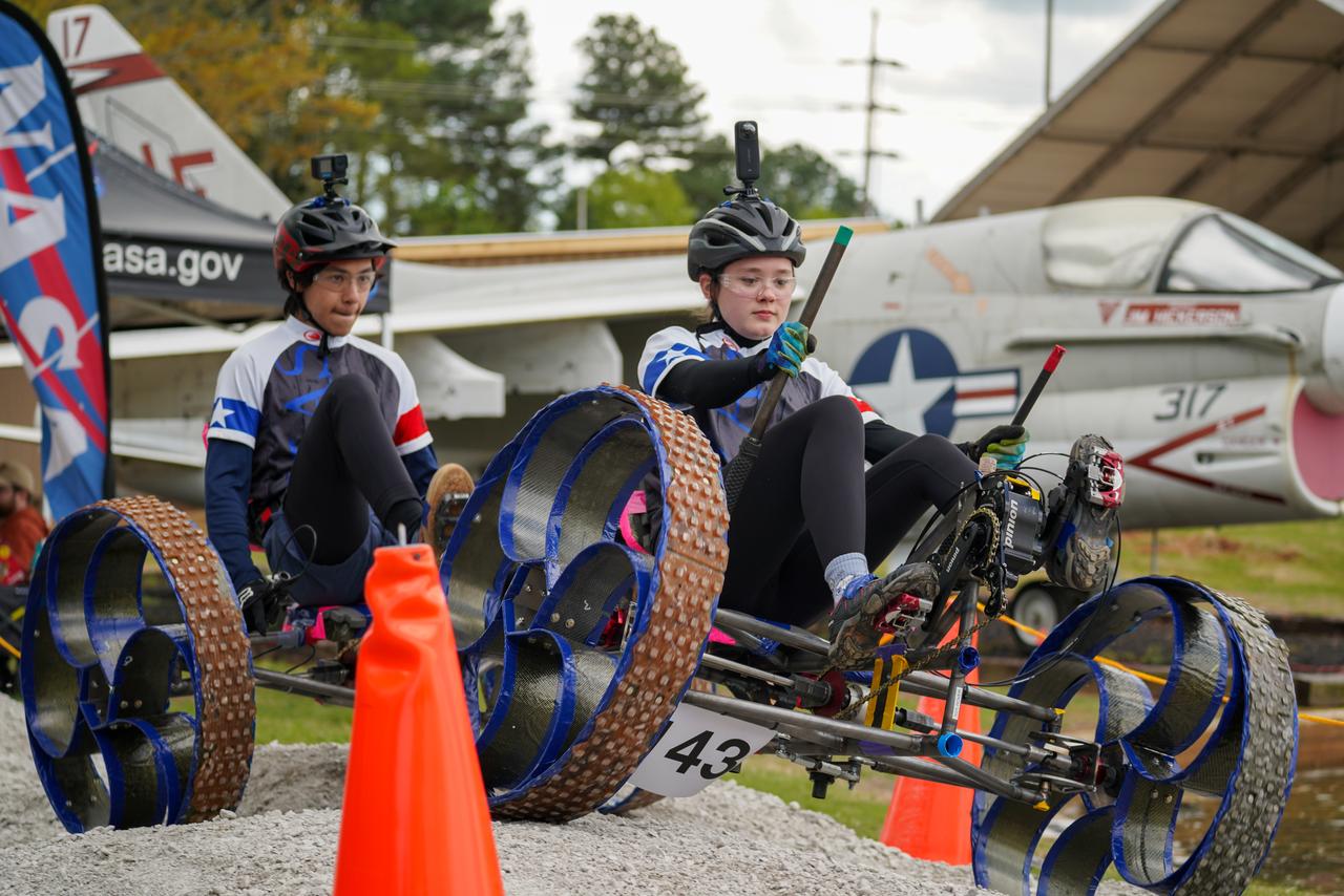
More than 500 students with 75 teams from around the world participated in the 31st year of NASA’s Human Exploration Rover Challenge (HERC) on April 11 and April 12, 2025, near NASA’s Marshall Space Flight Center in Huntsville, Alabama. Participating teams represented 35 colleges and universities, 38 high schools, and two middle schools from 20 states, Puerto Rico, and 16 other nations. NASA expanded the 2025 challenge to include a remote-control division - named Remote-Operated Vehicular Research - and invited middle school students to participate. Teams were awarded points based on navigating a half-mile obstacle course, conducting mission-specific task challenges, and completing multiple safety and design reviews with NASA engineers.

More than 500 students with 75 teams from around the world participated in the 31st year of NASA’s Human Exploration Rover Challenge (HERC) on April 11 and April 12, 2025, near NASA’s Marshall Space Flight Center in Huntsville, Alabama. Participating teams represented 35 colleges and universities, 38 high schools, and two middle schools from 20 states, Puerto Rico, and 16 other nations. NASA expanded the 2025 challenge to include a remote-control division - named Remote-Operated Vehicular Research - and invited middle school students to participate. Teams were awarded points based on navigating a half-mile obstacle course, conducting mission-specific task challenges, and completing multiple safety and design reviews with NASA engineers.

CAPE CANAVERAL, Fla. – Students from the University of Florida, University of Central Florida and the University of Puerto Rico brainstorm ideas during the 2013 International Space Apps Challenge, or ISAC, at The Astronaut Memorial Foundation’s Center for Space Education in Florida. During the worldwide two-day challenge, more than 9,000 people and 484 organizations came together in 83 cities across 44 countries, as well as online, to develop new ways of solving challenges that NASA faces. At Kennedy, four teams brainstormed ideas with subject matter experts and others and worked nearly 32 hours straight to present their concepts to a panel of three technical and non-technical judges. Challenges tackled at Kennedy were: Deployable Greenhouse, Kennedy Space Center 2040, Seven Minutes of Science, and Moonville – Lunar Industry Game. Photo credit: NASA_Charisse Nahser
More than 500 students with 75 teams from around the world participated in the 31st year of NASA’s Human Exploration Rover Challenge (HERC) on April 11 and April 12, 2025, near NASA’s Marshall Space Flight Center in Huntsville, Alabama. Participating teams represented 35 colleges and universities, 38 high schools, and two middle schools from 20 states, Puerto Rico, and 16 other nations. NASA expanded the 2025 challenge to include a remote-control division - named Remote-Operated Vehicular Research - and invited middle school students to participate. Teams were awarded points based on navigating a half-mile obstacle course, conducting mission-specific task challenges, and completing multiple safety and design reviews with NASA engineers.
More than 500 students with 75 teams from around the world participated in the 31st year of NASA’s Human Exploration Rover Challenge (HERC) on April 11 and April 12, 2025, near NASA’s Marshall Space Flight Center in Huntsville, Alabama. Participating teams represented 35 colleges and universities, 38 high schools, and two middle schools from 20 states, Puerto Rico, and 16 other nations. NASA expanded the 2025 challenge to include a remote-control division - named Remote-Operated Vehicular Research - and invited middle school students to participate. Teams were awarded points based on navigating a half-mile obstacle course, conducting mission-specific task challenges, and completing multiple safety and design reviews with NASA engineers.
The Swarmathon team from the University of Puerto Rico at Arecibo received the Best Poster Award during the awards ceremony for NASA’s Swarmathon University Challenge IV, at the Kennedy Space Center Visitor Complex in Florida on June 12, 2019. Students and mentors from some of the Swarmathon teams were at Kennedy to participate in a student/mentor panel, hear from speakers, get a behind-the-scenes tour of Kennedy Space Center, dine with an astronaut and receive awards. For the challenge, university students developed algorithms for robotic swarms that are robust and adaptable like the foraging strategies of ant colonies. The fourth and final Swarmathon challenge was a combined virtual and physical competition. Fourth from right is Melanie Moses, a professor of computer science at the University of New Mexico, the host location for Swarmathon. Second from right is Theresa Martinez, engagement manager of the Minority University Research and Education Program, managed at Kennedy.
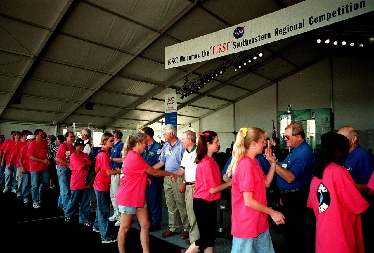
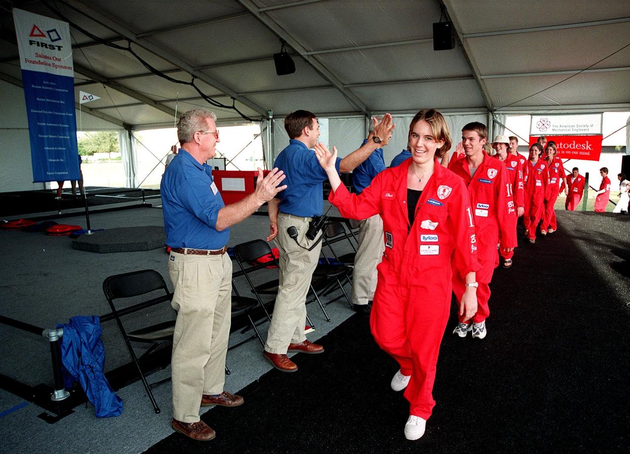
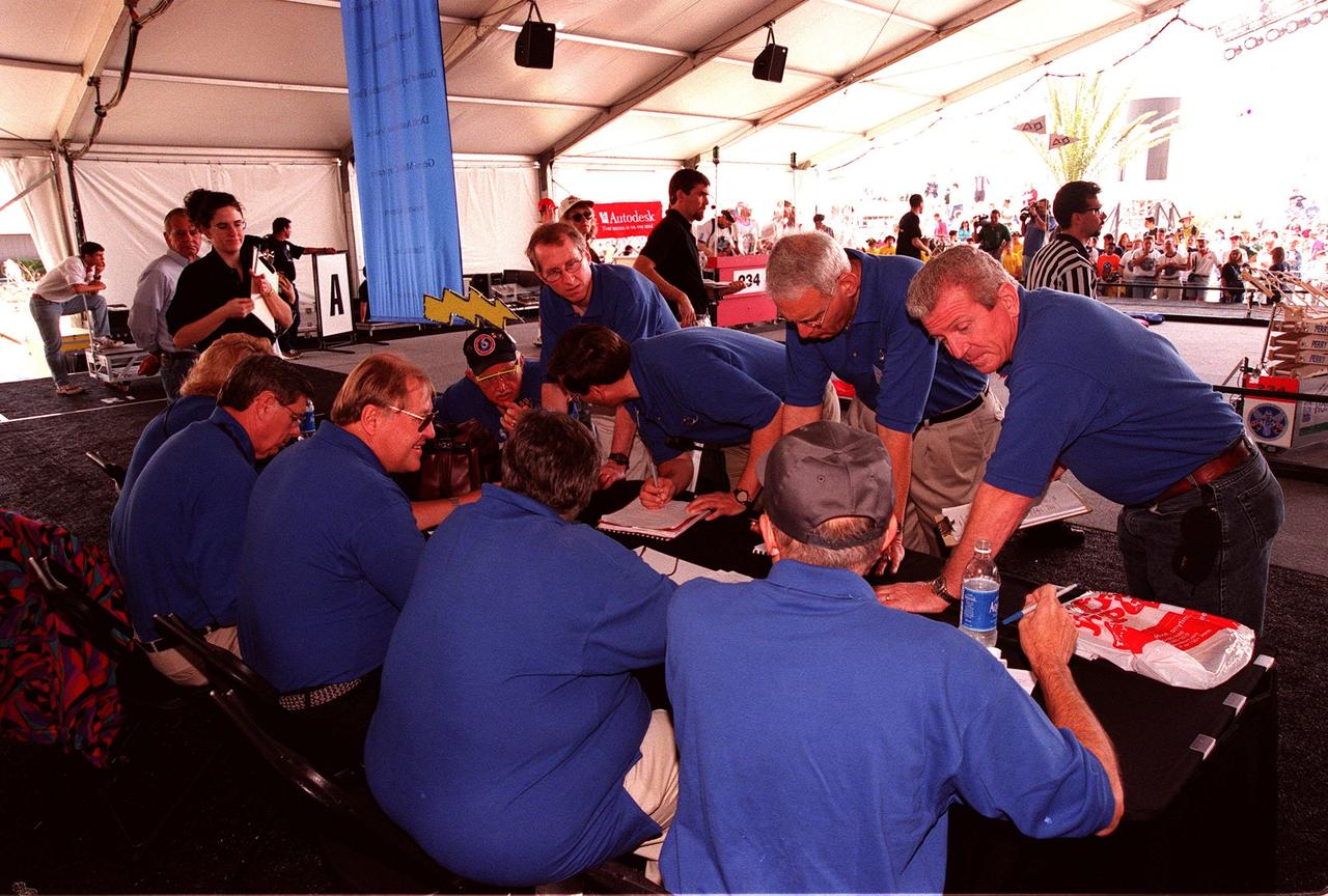
At the award ceremony for the 1999 FIRST Southeastern Regional robotic competition held at KSC, the Space Coast FIRST Team walks past the greeting line. In the middle, shaking hands with the team, are KSC's Director of Engineering Development Sterling Walker (left) and Center Director Roy Bridges (right). The Space Coast Team included Rockledge, Cocoa Beach and Merritt Island High Schools. FIRST is a nonprofit organization, For Inspiration and Recognition of Science and Technology, that sponsors the event pitting gladiator robots against each other in an athletic-style competition. The FIRST robotics competition is designed to provide students with a hands-on, inside look at engineering and other professional careers, pairing high school students with engineer mentors and corporations. The regional event comprised 27 teams. Along with the championship award, which went to high school teams from Miami and San German, Puerto Rico, 15 other awards were presented

More than 500 students with 75 teams from around the world participated in the 31st year of NASA’s Human Exploration Rover Challenge (HERC) on April 11 and April 12, 2025, near NASA’s Marshall Space Flight Center in Huntsville, Alabama. Participating teams represented 35 colleges and universities, 38 high schools, and two middle schools from 20 states, Puerto Rico, and 16 other nations. NASA expanded the 2025 challenge to include a remote-control division - named Remote-Operated Vehicular Research - and invited middle school students to participate. Teams were awarded points based on navigating a half-mile obstacle course, conducting mission-specific task challenges, and completing multiple safety and design reviews with NASA engineers.
More than 500 students with 75 teams from around the world participated in the 31st year of NASA’s Human Exploration Rover Challenge (HERC) on April 11 and April 12, 2025, near NASA’s Marshall Space Flight Center in Huntsville, Alabama. Participating teams represented 35 colleges and universities, 38 high schools, and two middle schools from 20 states, Puerto Rico, and 16 other nations. NASA expanded the 2025 challenge to include a remote-control division - named Remote-Operated Vehicular Research - and invited middle school students to participate. Teams were awarded points based on navigating a half-mile obstacle course, conducting mission-specific task challenges, and completing multiple safety and design reviews with NASA engineers.
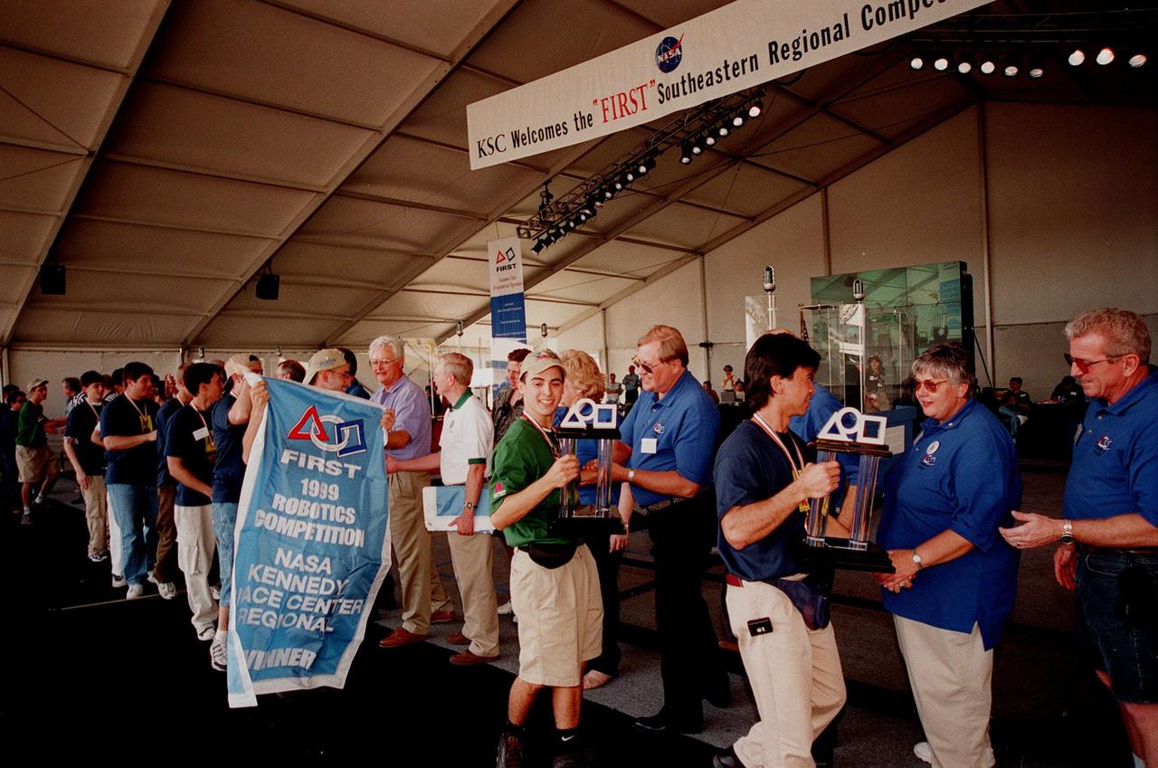
At the award ceremony for the 1999 FIRST Southeastern Regional robotic competition held at KSC, the winning teams from Miami and San German, Puerto Rico, parade with their trophies and championship flag by the line of judges and officials. In the middle of the line is Center Director Roy Bridges. At the far right is Deputy Director for Launch and Payload Processing Loren Shriver, who served as one of the judges for the competition. FIRST is a nonprofit organization, For Inspiration and Recognition of Science and Technology, that sponsors the event pitting gladiator robots against each other in an athletic-style competition. The FIRST robotics competition is designed to provide students with a hands-on, inside look at engineering and other professional careers, pairing high school students with engineer mentors and corporations. The regional event comprised 27 teams. Along with the championship award, 15 other awards were presented
More than 500 students with 75 teams from around the world participated in the 31st year of NASA’s Human Exploration Rover Challenge (HERC) on April 11 and April 12, 2025, near NASA’s Marshall Space Flight Center in Huntsville, Alabama. Participating teams represented 35 colleges and universities, 38 high schools, and two middle schools from 20 states, Puerto Rico, and 16 other nations. NASA expanded the 2025 challenge to include a remote-control division - named Remote-Operated Vehicular Research - and invited middle school students to participate. Teams were awarded points based on navigating a half-mile obstacle course, conducting mission-specific task challenges, and completing multiple safety and design reviews with NASA engineers.
At the start of the award ceremony at the 1999 FIRST Southeastern Regional robotic competition held at KSC, judges, including Deputy Director for Launch and Payload Processing Loren Shriver (left), give "high fives" to a winning team from Minnesota as they enter. FIRST is a nonprofit organization, For Inspiration and Recognition of Science and Technology, that sponsors the event pitting gladiator robots against each other in an athletic-style competition. The FIRST robotics competition is designed to provide students with a hands-on, inside look at engineering and other professional careers, pairing high school students with engineer mentors and corporations. The regional event comprised 27 teams. Along with the championship award, which went to high school teams in Miami and San German, Puerto Rico, 15 other awards were presented

At the award ceremony for the 1999 FIRST Southeastern Regional robotic competition held at KSC, one of the winning teams, from Ocoee, Fla., is greeted by (left to right) astronaut David Brown, Deputy Director for Launch and Payload Processing Loren Shriver, Center Director Roy Bridges, and two unidentified judges. FIRST is a nonprofit organization, For Inspiration and Recognition of Science and Technology, that sponsors the event pitting gladiator robots against each other in an athletic-style competition. The FIRST robotics competition is designed to provide students with a hands-on, inside look at engineering and other professional careers, pairing high school students with engineer mentors and corporations. The regional event comprised 27 teams. Along with the championship award, which went to high school teams from Miami and San German, Puerto Rico, 15 other awards were presented
At the 1999 FIRST Southeastern Regional robotic competition held at KSC, judges compare notes about a match. Serving as judges are Deputy Director for Launch and Payload Processing Loren Shriver (above right) and former KSC Director of Shuttle Processing Robert Sieck (below, with back to camera). FIRST is a nonprofit organization, For Inspiration and Recognition of Science and Technology, that sponsors the event pitting gladiator robots against each other in an athletic-style competition. The FIRST robotics competition is designed to provide students with a hands-on, inside look at engineering and other professional careers, pairing high school students with engineer mentors and corporations. The regional event comprised 27 teams. Along with the championship award, which went to high school teams in Miami and San German, Puerto Rico, 15 other awards were presented
This false-color image shows the amount of atmospheric water vapor observed by AIRS two weeks prior to the passage of Hurricane Isabel, and then when it was a Category 5 storm. The region shown includes parts of South America and the West Indies. Puerto Rico is the large island below the upper left corner. Total water vapor represents the depth of a layer if all the water vapor in the atmosphere were to condense and fall to the surface. The color bar on the right sides of the plots give the thickness of this layer in millimeters (mm). The first image, from August 28, shows typical tropical water vapor amounts over the ocean: between roughly 25 and 50 mm, or 1 to 2 inches. The highest values of roughly 80 mm, seen as a red blob over South America, corresponds to intense thunderstorms. Thunderstorms pull in water vapor from surrounding regions and concentrate it, with much of it then falling as rain. http://photojournal.jpl.nasa.gov/catalog/PIA00430
More than 500 students with 75 teams from around the world participated in the 31st year of NASA’s Human Exploration Rover Challenge (HERC) on April 11 and April 12, 2025, near NASA’s Marshall Space Flight Center in Huntsville, Alabama. Participating teams represented 35 colleges and universities, 38 high schools, and two middle schools from 20 states, Puerto Rico, and 16 other nations. NASA expanded the 2025 challenge to include a remote-control division - named Remote-Operated Vehicular Research - and invited middle school students to participate. Teams were awarded points based on navigating a half-mile obstacle course, conducting mission-specific task challenges, and completing multiple safety and design reviews with NASA engineers.
Kicking off the award ceremony at the 1999 FIRST Southeastern Regional robotic competition held at KSC are David Brown, Executive Director of FIRST; Woody Flowers, national advisor for FIRST; and astronaut David Brown. FIRST is a nonprofit organization, For Inspiration and Recognition of Science and Technology, that sponsors the event pitting gladiator robots against each other in an athletic-style competition. The FIRST robotics competition is designed to provide students with a hands-on, inside look at engineering and other professional careers, pairing high school students with engineer mentors and corporations. The regional event comprised 27 teams. Along with the championship award, which went to high school teams in Miami and San German, Puerto Rico, 15 other awards were presented
More than 500 students with 75 teams from around the world participated in the 31st year of NASA’s Human Exploration Rover Challenge (HERC) on April 11 and April 12, 2025, near NASA’s Marshall Space Flight Center in Huntsville, Alabama. Participating teams represented 35 colleges and universities, 38 high schools, and two middle schools from 20 states, Puerto Rico, and 16 other nations. NASA expanded the 2025 challenge to include a remote-control division - named Remote-Operated Vehicular Research - and invited middle school students to participate. Teams were awarded points based on navigating a half-mile obstacle course, conducting mission-specific task challenges, and completing multiple safety and design reviews with NASA engineers.
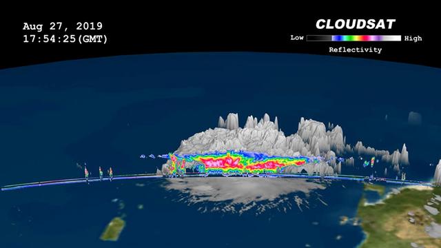
On, Aug. 27, 2019 NASA's CloudSat satellite passed over Dorian, still a tropical storm at the time, near Puerto Rico. CloudSat uses an advanced cloud-profiling radar that "slices" through clouds giving us the ability to see how tall they are, where the different cloud layers are, and where the heavier bands of rain are found within the storm system. The 3D animation shows Dorian when it had maximum sustained winds of 52 mph (84 kph) with some of its cloud tops extending about 9 miles (15 kilometer) into the atmosphere. The colors represent the size of water or ice droplets inside the storm — deep red and pink indicate larger droplets with areas of moderate and heavy rainfall. Movie available at https://photojournal.jpl.nasa.gov/catalog/PIA23359
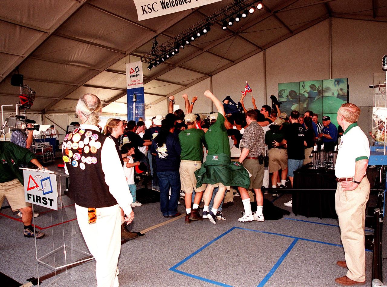
At the award ceremony for the 1999 FIRST Southeastern Regional robotic competition held at KSC, the winning teams, from Miami and San German, Puerto Rico, jump for joy and wave a flag. In the foreground, at left, are Woody Flowers, national advisor to FIRST, and at right, Roy Bridges, KSC director. FIRST is a nonprofit organization, For Inspiration and Recognition of Science and Technology, that sponsors the event pitting gladiator robots against each other in an athletic-style competition. The FIRST robotics competition is designed to provide students with a hands-on, inside look at engineering and other professional careers, pairing high school students with engineer mentors and corporations. The regional event comprised 27 teams. Along with the championship award, 15 other awards were presented
More than 500 students with 75 teams from around the world participated in the 31st year of NASA’s Human Exploration Rover Challenge (HERC) on April 11 and April 12, 2025, near NASA’s Marshall Space Flight Center in Huntsville, Alabama. Participating teams represented 35 colleges and universities, 38 high schools, and two middle schools from 20 states, Puerto Rico, and 16 other nations. NASA expanded the 2025 challenge to include a remote-control division - named Remote-Operated Vehicular Research - and invited middle school students to participate. Teams were awarded points based on navigating a half-mile obstacle course, conducting mission-specific task challenges, and completing multiple safety and design reviews with NASA engineers.
NASA launched a Terrier-Improved Malemute suborbital sounding rocket carrying the RockSat-X payload with university and community college student experiments at 6:04 a.m. EDT Wednesday, Aug. 12, from NASA’s Wallops Flight Facilityin Virginia. More than 60 students and instructors from across the continental United States, Hawaii and Puerto Rico were on hand to witness the launch of their experiments. The payload flew to an altitude of about 97 miles and descended via parachute into the Atlantic Ocean off the coast of Wallops. Payload recovery operations began after lift-off. Developed by students from seven higher education programs, the experiments flew through the RockSat-X program in conjunction with the Colorado Space Grant Consortium. Participating institutions in this flight are the University of Colorado, Boulder; Northwest Nazarene University, Nampa, Idaho; the University of Puerto Rico; the University of Nebraska, Lincoln; Virginia Tech University, Blacksburg; Capitol Technology University, Laurel, Maryland; and University of Hawai'i Community Colleges at the Honolulu, Kapi'olani, Kaua'i, and Windward campuses. The next launch scheduled from Wallops is a NASA Black Brant IX suborbital sounding rocket carrying several technology development instruments. The launch is scheduled between 7 and 7:41 p.m. Sept. 29. The backup launch days are Sept. 30 through Oct. 12. <b><a href="http://www.nasa.gov/audience/formedia/features/MP_Photo_Guidelines.html" rel="nofollow">NASA image use policy.</a></b> <b><a href="http://www.nasa.gov/centers/goddard/home/index.html" rel="nofollow">NASA Goddard Space Flight Center</a></b> enables NASA’s mission through four scientific endeavors: Earth Science, Heliophysics, Solar System Exploration, and Astrophysics. Goddard plays a leading role in NASA’s accomplishments by contributing compelling scientific knowledge to advance the Agency’s mission. <b>Follow us on <a href="http://twitter.com/NASAGoddardPix" rel="nofollow">Twitter</a></b> <b>Like us on <a href="http://www.facebook.com/pages/Greenbelt-MD/NASA-Goddard/395013845897?ref=tsd" rel="nofollow">Facebook</a></b> <b>Find us on <a href="http://instagrid.me/nasagoddard/?vm=grid" rel="nofollow">Instagram</a></b>
NASA's CloudSat satellite flew over Hurricane Irma on Sept. 6, 2017 at 1:45 p.m. EDT (17:45 UTC) as the storm was approaching Puerto Rico in the Atlantic Ocean. Hurricane Irma contained estimated maximum sustained winds of 185 miles per hour (160 knots) with a minimum pressure of 918 millibars. CloudSat transected the eastern edge of Hurricane Irma's eyewall, revealing details of the storm's cloud structure beneath its thick canopy of cirrus clouds. The CloudSat Cloud Profiling Radar excels in detecting the organization and placement of cloud layers beneath a storm's cirrus canopy, which are not readily detected by other satellite sensors. The CloudSat overpass reveals the inner details beneath the cloud tops of this large system; intense areas of convection with moderate to heavy rainfall (deep red and pink colors), cloud-free areas (moats) in between the inner and outer cloud bands of Hurricane Irma and cloud top heights averaging around 9 to 10 miles (15 to 16 kilometers). Lower values of reflectivity (areas of green and blue) denote smaller-sized ice and water particle sizes typically located at the top of a storm system (in the anvil area). The Cloud Profiling Radar loses signal at around 3 miles (5 kilometers) in height (in the melting layer) due to water (ice) particles larger than 0.12 inches (3 millimeters) in diameter. Moderate to heavy rainfall occurs in these areas where signal weakening is detectable. Smaller cumulus and cumulonimbus cloud types are evident as CloudSat moves farther south, beneath the thick cirrus canopy. An animation is available at https://photojournal.jpl.nasa.gov/catalog/PIA21947
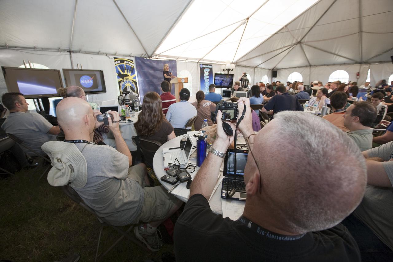
CAPE CANAVERAL, Fla. - At NASA's Kennedy Space Center in Florida, NASA's space shuttle Discovery Flow Director Stephanie Stilson has a rapt audience in the participants of NASA's STS-132 Tweetup. NASA is hosting 150 people from around the world and providing them with a behind-the-scenes perspective to share with their followers via the social networking service Twitter. Attendees were randomly selected from more than 1,000 online registrations and include people from more than 30 states, the District of Columbia, Puerto Rico, the Netherlands, New Zealand and England. The Tweeters are being given the chance to meet with shuttle technicians, managers, engineers and astronauts, to take a tour of Kennedy, and to experience the exhilaration of the launch of space shuttle Atlantis' STS-132 mission. A tent was set up especially for the occasion near the countdown clock at Kennedy's Press Site. Atlantis' liftoff is set for 2:20 p.m. EDT on May 14. STS-132 is the 34th mission to the station and the last scheduled flight for Atlantis. For more information on the STS-132 mission objectives, payload and crew, visit http:__www.nasa.gov_mission_pages_shuttle_shuttlemissions_sts132_index.html. Photo Credit: NASA_Amanda Diller

NMTSat is a student-built satellite built by undergraduate and graduates students primarily from New Mexico Tech. NMTSat is designed to operate five sensors in four experiments in space for 3 months of data collection. The experiments will provide data on earth’s magnetic field, high altitude plasma density, atmospheric weather measurements, and an optical beacon experiment. Approximately 50 students have contributed to NMTSat and its design not including the students and groups who have developed the science instruments. NMTSat CubeSat is providing the opportunity for these science experiments to be conducted on orbit and demonstrates the collaborative nature of the Educational Launch of Nano Satellite (ELaNa) Program at NASA. The instruments have been contributed by New Mexico Tech, Turabo University in Puerto Rico, Los Alamos National Laboratory, and Atmospheric and Space Technology Research Associates (ASTRA) in Boulder, CO. Dr. Anders M. Jorgensen, Associate Professor at New Mexico Tech is the PI and Dr. Hien Vo from Vietnamese-German University in Ho Chi Minh University in Vietnam is a Co-Investigator. NMTSat is funded by the New Mexico NASA EPSCoR program as well as New Mexico Tech.
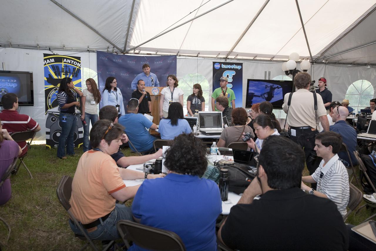
CAPE CANAVERAL, Fla. - At NASA's Kennedy Space Center in Florida, the support personnel for NASA's STS-132 Tweetup introduce themselves to the participants. NASA is hosting 150 people from around the world and providing them with a behind-the-scenes perspective to share with their followers via the social networking service Twitter. Attendees were randomly selected from more than 1,000 online registrations and include people from more than 30 states, the District of Columbia, Puerto Rico, the Netherlands, New Zealand and England. The Tweeters are being given the chance to meet with shuttle technicians, managers, engineers and astronauts, to take a tour of Kennedy, and to experience the exhilaration of the launch of space shuttle Atlantis' STS-132 mission. A tent was set up especially for the occasion near the countdown clock at Kennedy's Press Site. Atlantis' liftoff is set for 2:20 p.m. EDT on May 14. STS-132 is the 34th mission to the station and the last scheduled flight for Atlantis. For more information on the STS-132 mission objectives, payload and crew, visit http:__www.nasa.gov_mission_pages_shuttle_shuttlemissions_sts132_index.html. Photo Credit: NASA_Amanda Diller

NMTSat is a student-built satellite built by undergraduate and graduates students primarily from New Mexico Tech. NMTSat is designed to operate five sensors in four experiments in space for 3 months of data collection. The experiments will provide data on earth’s magnetic field, high altitude plasma density, atmospheric weather measurements, and an optical beacon experiment. Approximately 50 students have contributed to NMTSat and its design not including the students and groups who have developed the science instruments. NMTSat CubeSat is providing the opportunity for these science experiments to be conducted on orbit and demonstrates the collaborative nature of the Educational Launch of Nano Satellite (ELaNa) Program at NASA. The instruments have been contributed by New Mexico Tech, Turabo University in Puerto Rico, Los Alamos National Laboratory, and Atmospheric and Space Technology Research Associates (ASTRA) in Boulder, CO. Dr. Anders M. Jorgensen, Associate Professor at New Mexico Tech is the PI and Dr. Hien Vo from Vietnamese-German University in Ho Chi Minh University in Vietnam is a Co-Investigator. NMTSat is funded by the New Mexico NASA EPSCoR program as well as New Mexico Tech.
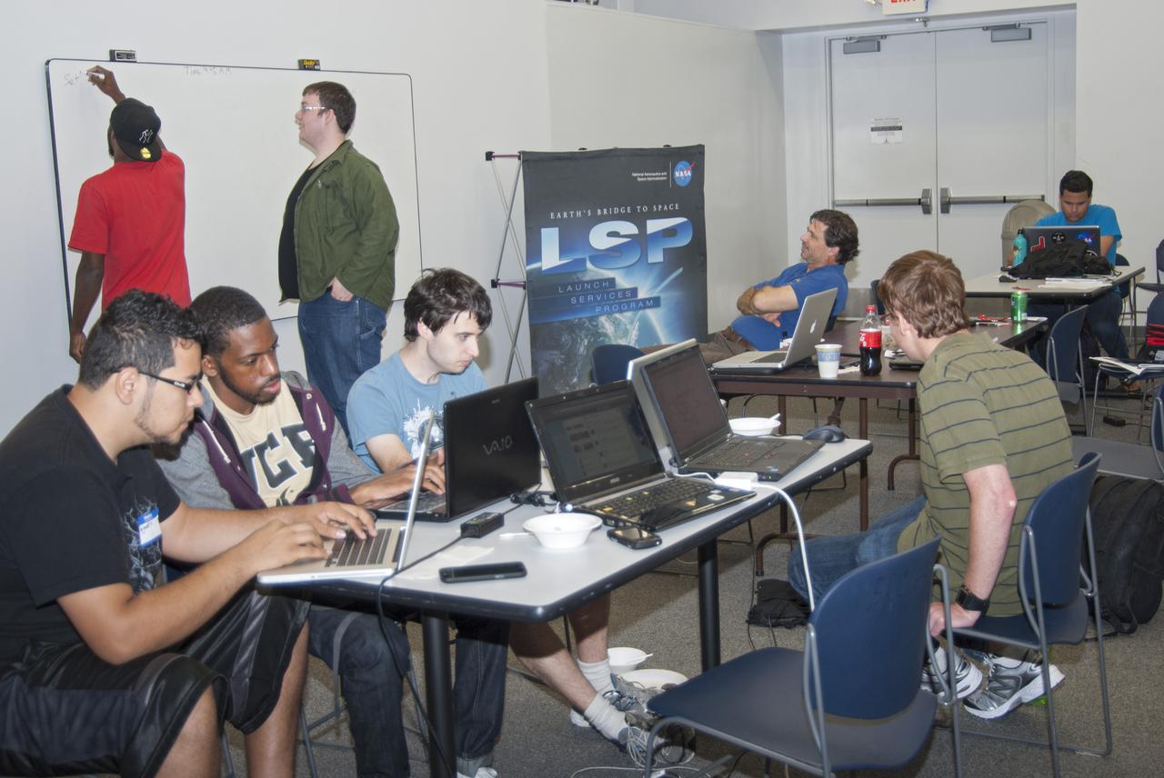
CAPE CANAVERAL, Fla. – Students from the University of Florida, the University of Central Florida, the University of Puerto Rico and private citizens brainstorm ideas during the 2013 International Space Apps Challenge, or ISAC, at The Astronaut Memorial Foundation’s Center for Space Education in Florida. Seated near the Launch Services Program poster is NASA subject matter expert Dr. Phil Metzger from Kennedy Space Center’s Swampworks Laboratory. During the worldwide two-day challenge, more than 9,000 people and 484 organizations came together in 83 cities across 44 countries, as well as online, to develop new ways of solving challenges that NASA faces. At Kennedy, four teams brainstormed ideas with subject matter experts and others and worked nearly 32 hours straight to present their concepts to a panel of three technical and non-technical judges. Challenges tackled at Kennedy were: Deployable Greenhouse, Kennedy Space Center 2040, Seven Minutes of Science, and Moonville – Lunar Industry Game. Photo credit: NASA_Charisse Nahser

NMTSat is a student-built satellite built by undergraduate and graduates students primarily from New Mexico Tech. NMTSat is designed to operate five sensors in four experiments in space for 3 months of data collection. The experiments will provide data on earth’s magnetic field, high altitude plasma density, atmospheric weather measurements, and an optical beacon experiment. Approximately 50 students have contributed to NMTSat and its design not including the students and groups who have developed the science instruments. NMTSat CubeSat is providing the opportunity for these science experiments to be conducted on orbit and demonstrates the collaborative nature of the Educational Launch of Nano Satellite (ELaNa) Program at NASA. The instruments have been contributed by New Mexico Tech, Turabo University in Puerto Rico, Los Alamos National Laboratory, and Atmospheric and Space Technology Research Associates (ASTRA) in Boulder, CO. Dr. Anders M. Jorgensen, Associate Professor at New Mexico Tech is the PI and Dr. Hien Vo from Vietnamese-German University in Ho Chi Minh University in Vietnam is a Co-Investigator. NMTSat is funded by the New Mexico NASA EPSCoR program as well as New Mexico Tech.

A Mod-1 2000-kilowatt wind turbine designed by National Aeronautics and Space Administration (NASA) Lewis Research Center and constructed in Boone, North Carolina. The wind turbine program was a joint program between NASA and the Energy Research and Development Administration (ERDA) during the 1970s to develop less expensive forms of energy. NASA Lewis was assigned the responsibility of developing large horizontal-axis wind turbines. The program included a series of increasingly powerful wind turbines, designated: Mod-0A, Mod-1, WTS-4, and Mod-5. The program’s first device was a Mod-0 100-kilowatt wind turbine test bed at NASA’s Plum Brook Station. There were four Mod-0A 200-kilowatt turbines built in New Mexico, Hawaii, Puerto Rico, and Rhode Island. The 2000-kilowatt wind turbine in North Carolina, seen here, was the only Mod-1 machine constructed. The two-bladed, 200-foot diameter device was built in May 1979 and began operation that September. The Mod-1 turbine performed exceedingly well and was fully integrated into the local power grid. NASA researchers also used the North Carolina device to study its effect on noise and television transmission.

A Mod-0A 200-kilowatt wind turbine designed by National Aeronautics and Space Administration (NASA) Lewis Research Center and constructed in Block Island, Rhode Island. The wind turbine program was a joint program between NASA and the Energy Research and Development Administration (ERDA) during the 1970s to develop less expensive forms of energy. NASA Lewis was assigned the responsibility of developing large horizontal-axis wind turbines. The program included a series of increasingly powerful wind turbines, designated: Mod-0A, Mod-1, WTS-4, and Mod-5. The program’s first device was a Mod-0 100-kilowatt wind turbine test bed at NASA’s Plum Brook Station. This Mod-0A 200-kilowatt turbine, completed in 1977, was the program’s second-generation device. It included a 125-foot diameter blade atop a 100-foot tall tower. This early wind turbine was designed determine its operating problems, integrate with the local utilities, and assess the attitude of the local community. There were additional Mod-0A turbines built in Culebra, Puerto Rico; Clayton, New Mexico; and Oahu, Hawaii. The Mod-0A turbines suffered durability issues with the rotor blade and initially appeared unreliable. NASA engineers addressed the problems, and the turbines proved to be reliable and efficient devices that operated for a number of years. The information gained from these early models was vital to the design and improvement of the later generations.
This false-color image shows Hurricane Isabel viewed by the AIRS and AMSU-A instruments at 1:30 EDT in the morning of Thursday September 18, 2003. Isabel will be ashore within 12 hours, bringing widespread flooding and destructive winds. In figure 1 on the left, data retrieved by the AIRS infrared sensor shows the hurricane's eye as the small ring of pale blue near the upper left corner of the image. The dark blue band around the eye shows the cold tops of hundreds of powerful thunderstorms. These storms are embedded in the 120 mile per hour winds swirling counterclockwise around Isabel's eye. Cape Hatteras is the finger of land north-northwest of the eye. Isabel's winds will soon push ashore a 4- to 8-foot high mound of 'storm surge' and accompanying high surf, leading to flooding of Cape Hatteras and other islands of North Carolina's Outer Banks. Also seen in the image are several organized bands of cold, (blue) thunderstorm tops being pulled into the storm center. Other thunderstorm are forming north of the islands of Jamaica, Cuba, Hispaniola and Puerto Rico near the bottom of the picture. http://photojournal.jpl.nasa.gov/catalog/PIA00428
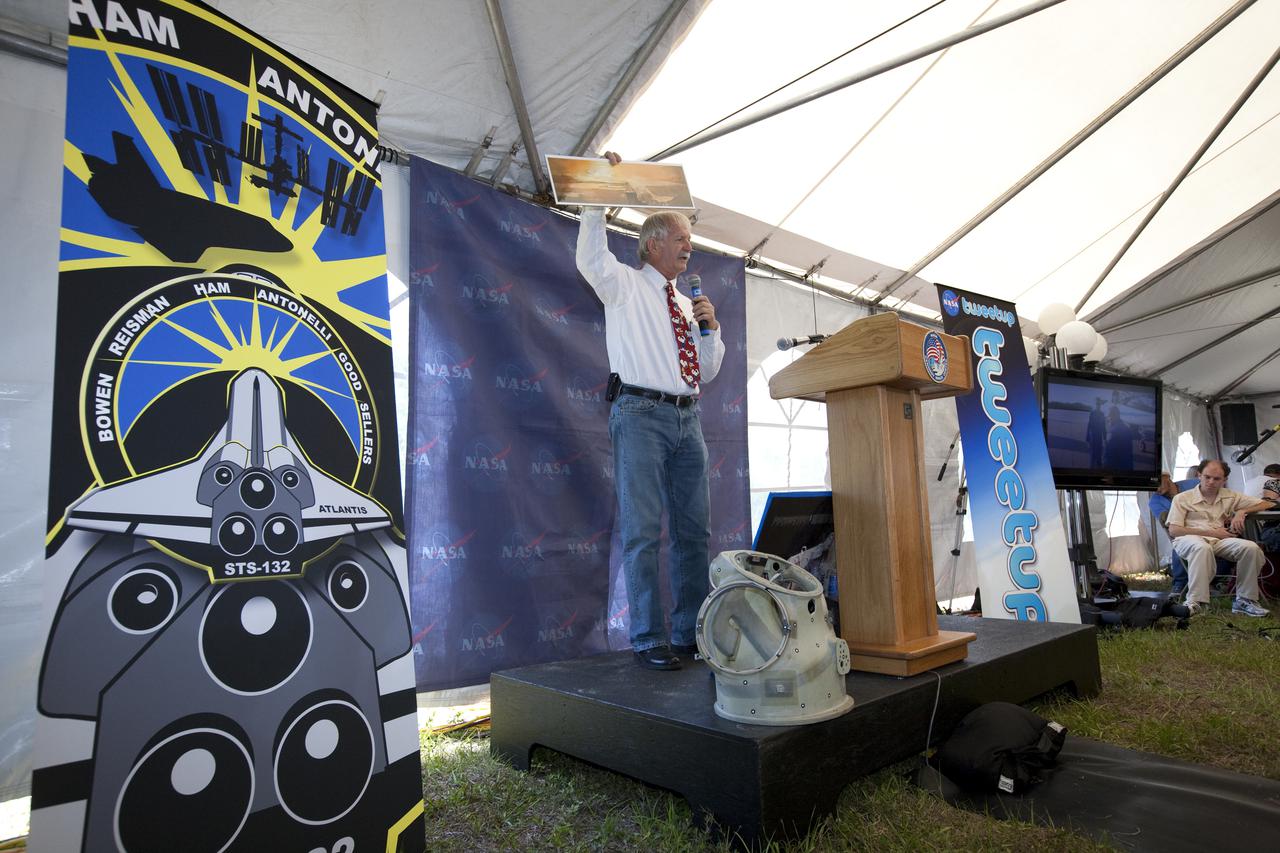
CAPE CANAVERAL, Fla. - At NASA's Kennedy Space Center in Florida, NASA's Ron Woods, a flight crew equipment specialist, presents one of his space-themed paintings to the participants in NASA's STS-132 Tweetup. NASA is hosting 150 people from around the world and providing them with a behind-the-scenes perspective to share with their followers via the social networking service Twitter. Attendees were randomly selected from more than 1,000 online registrations and include people from more than 30 states, the District of Columbia, Puerto Rico, the Netherlands, New Zealand and England. The Tweeters are being given the chance to meet with shuttle technicians, managers, engineers and astronauts, to take a tour of Kennedy, and to experience the exhilaration of the launch of space shuttle Atlantis' STS-132 mission. A tent was set up especially for the occasion near the countdown clock at Kennedy's Press Site. Atlantis' liftoff is set for 2:20 p.m. EDT on May 14. STS-132 is the 34th mission to the station and the last scheduled flight for Atlantis. For more information on the STS-132 mission objectives, payload and crew, visit http:__www.nasa.gov_mission_pages_shuttle_shuttlemissions_sts132_index.html. Photo Credit: NASA_Amanda Diller
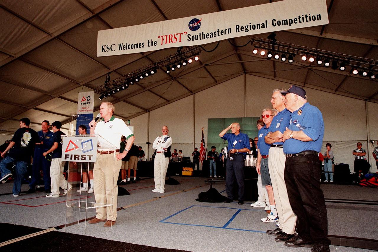
At the award ceremony for the 1999 FIRST Southeastern Regional robotic competition held at KSC, Center Director Roy Bridges addresses the teams, encouraging them to continue their interest in engineering. Directly behind him (left) are Woody Flowers, national advisor to FIRST, and (right) former KSC Director of Shuttle Processing Robert Sieck, who served as one of the judges. At the far left, students gather around astronaut David Brown, who was present during the two days of matches. At right are other judges, including Deputy Director for Launch and Payload Processing Loren Shriver (third from right). FIRST is a nonprofit organization, For Inspiration and Recognition of Science and Technology, that sponsors the event pitting gladiator robots against each other in an athletic-style competition. The FIRST robotics competition is designed to provide students with a hands-on, inside look at engineering and other professional careers, pairing high school students with engineer mentors and corporations. The regional event comprised 27 teams. Along with the championship award, which went to high school teams in Miami and San German, Puerto Rico, 15 other awards were presented

“My background and experience have been unique. I didn't grow up in space. I didn't grow up in a family of people who watched the Moon landing. I came to discover space at a much later age. That and the fact that I come from the cultural background I come from (being born and raised in Puerto Rico), has always made me question some of the assumptions about why we do what we do in space and how we go about it. “In my experience and in my career that has proven effective because people want the challenge, and they want to engage everyone and make sure that the best of the best are participating. I have found myself in settings where my point of view has been valued because I was asking some of the questions that some folks took for granted. “I think it’s also that I came at a good time when we are having these important discussions about diversity and inclusion, and people do want these different kinds of views. Space is so international now that this diversity is such an important aspect of it too. Even as an adult starting to learn about these topics, it was natural for me to be having these discussions with other colleagues from Latin America and South Africa and Australia. It’s a key feature of my own experience but also, I think, the time that we’re living right now, which is really exciting.” Laura M. Delgado López, Policy Analyst for NASA’s Science Mission Directorate, poses for a portrait on Monday, Sept. 21, 2020 in Virginia. Photo Credit: (NASA/Joel Kowsky)
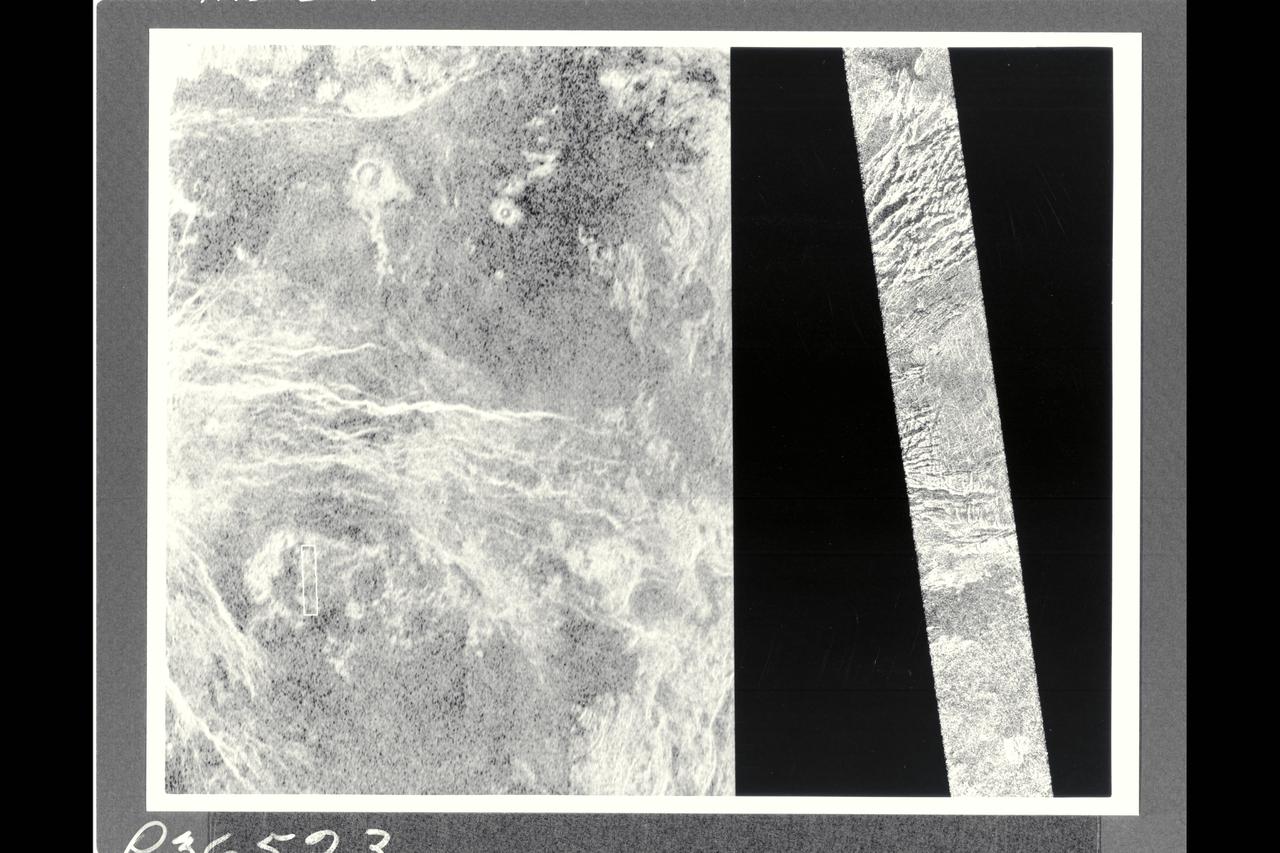
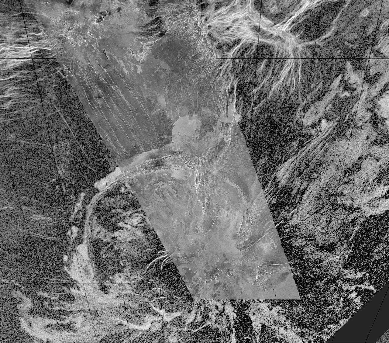
This image shows a comparison between a Magellan image (right) and the highest resolution Earth-based radar image of Venus, obtained by the US National Astronomy and Ionosphere Center's Arecibo Observatory in Puerto Rico. The small white bot in the Arecibo image on the left corresponds to the Magellan image. This portion of a Magellan radar image strip shows a small region on the east flank of a major volcanic upland called Beta Regio. The image is centered a t 23 degrees north latitude and 286.7 degrees east longitude. The ridge and valley network in the middle part of the image is formed by intersecting faults which have broken the Venusian crust into a complex deformed type of surface called tessera, the Latin word for tile. The parallel mountains and valleys resemble the Basin and Range Province kn the western United States. The irregular dark patch near the top of the image is a smooth surface, proboably formed by lava flows in a region about 10 km (6 mi.) across. Similar dark surfaces within the valleys indicate lava flows that are younger than the tessera. The Arecibo image contains probable impact craters, mapped in detail by Magellan. The Magellan image has a resolution of 120 meters, (400 feet). The image segment is 20 km (12.4 mi.) wide adn 150 km (90 mi.) long. The Arecibo image has a resolution of 1-3 km (0.6-1.8 mi.) and is approx. 900 km (550 mi.) across.
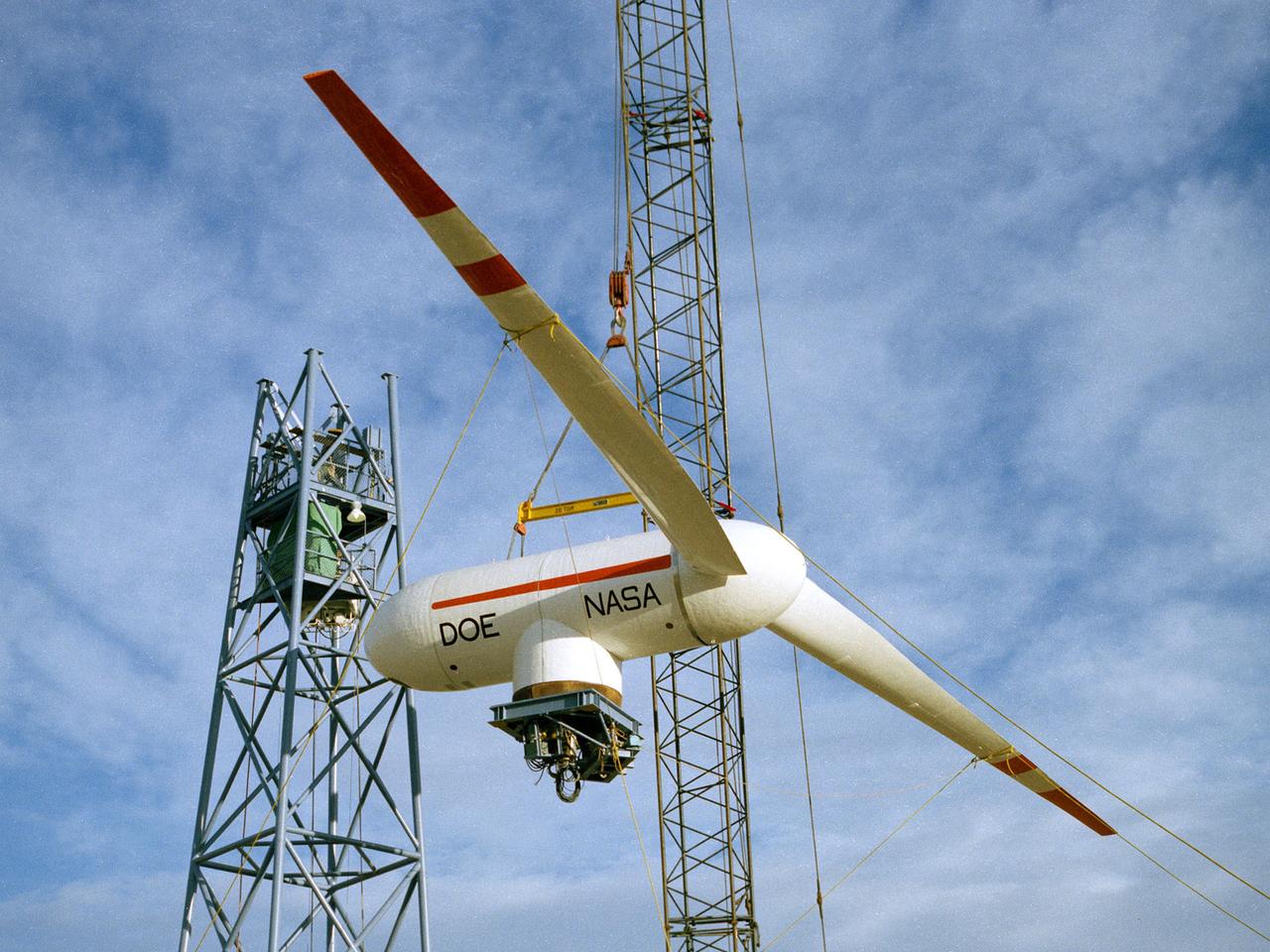
TA Mod-0A 200-kilowatt wind turbine designed by National Aeronautics and Space Administration (NASA) Lewis Research Center and constructed in Clayton, New Mexico. The wind turbine program was a joint effort by NASA and the Energy Research and Development Administration (ERDA) during the 1970s to develop less expensive forms of energy. NASA Lewis was assigned the responsibility of developing large horizontal-axis wind turbines. The program included a series of increasingly powerful wind turbines, designated: Mod-0A, Mod-1, WTS-4, and Mod-5. The program’s first device was a Mod-0 100-kilowatt wind turbine test bed built at NASA’s Plum Brook Station. This Mod-0A 200-kilowatt turbine built in Clayton in 1977 was the program’s second device. It included a 125-foot long blade atop a 100-foot tall tower. The Mod-0A was designed to determine the turbine’s operating problems, integrate the system with the local utilities, and assess the attitude of the local community. There were additional Mod-0A turbines built in Culebra, Puerto Rico; Block Island, Rhode Island; and Oahu, Hawaii. The Mod-0A turbines were initially unreliable and suffered issues with the durability of the rotor blade. Lewis engineers addressed the problems, and the wind turbines proved to be reliable and efficient devices that operated for a number of years. The information gained from these early models was vital to the design and improvement of the later generations.
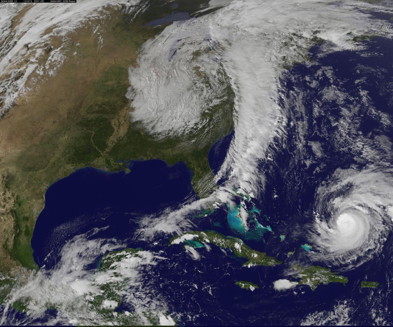
NASA image acquired acquired October 28, 2012 <b>For the latest info from NASA on Hurricane Sandy go to: <a href="http://1.usa.gov/Ti5SgS" rel="nofollow">1.usa.gov/Ti5SgS</a></b> At noon Eastern Daylight Time (16:00 Universal Time) on October 28, 2012, the Moderate Resolution Imaging Spectroradiometer (MODIS) on NASA’s Terra satellite acquired this image of Hurricane Sandy off the southeastern United States. At 11 a.m. local time (one hour before the image was captured), the U.S. National Hurricane Center reported that the storm was located at 32.5° North and 72.6° West, about 250 miles (400 kilometers) southeast of Cape Hatteras, North Carolina, and 575 miles (930 kilometers) south of New York City. Maximum sustained winds were 75 miles (120 kilometers) per hour, and the central pressure was 951 millibars (28.08 inches). Forecasters predicted that the storm would continue heading north-northeast until the morning of October and then take a hard turn to the northwest into the coastaline of Delaware, New Jersey, or New York. The wind field from the storm was said to stretch 500 to 700 miles and was likely to affect an area from South Carolina to Maine, and as far inland as the Great Lakes. The storm has already caused significant damage in the Bahamas, Cuba, Jamaica, Puerto Rico, the Dominican Republic, and Haiti; at least 65 lives have been lost to the storm. NASA image courtesy LANCE MODIS Rapid Response Team at NASA GSFC. Caption by Michael Carlowicz. Instrument: Terra - MODIS Credit: <b><a href="http://www.earthobservatory.nasa.gov/" rel="nofollow"> NASA Earth Observatory</a></b> <b><a href="http://www.nasa.gov/audience/formedia/features/MP_Photo_Guidelines.html" rel="nofollow">NASA image use policy.</a></b> <b><a href="http://www.nasa.gov/centers/goddard/home/index.html" rel="nofollow">NASA Goddard Space Flight Center</a></b> enables NASA’s mission through four scientific endeavors: Earth Science, Heliophysics, Solar System Exploration, and Astrophysics. Goddard plays a leading role in NASA’s accomplishments by contributing compelling scientific knowledge to advance the Agency’s mission. <b>Follow us on <a href="http://twitter.com/NASA_GoddardPix" rel="nofollow">Twitter</a></b> <b>Like us on <a href="http://www.facebook.com/pages/Greenbelt-MD/NASA-Goddard/395013845897?ref=tsd" rel="nofollow">Facebook</a></b> <b>Find us on <a href="http://instagrid.me/nasagoddard/?vm=grid" rel="nofollow">Instagram</a></b>
Hurricane Gonzalo has made the jump to major hurricane status and on Oct. 15 was a Category 4 storm on the Saffir-Simpson Hurricane Scale. NOAA's GOES-East satellite provided imagery of the storm. According to the National Hurricane Center, Gonzalo is the first category 4 hurricane in the Atlantic basin since Ophelia in 2011. NOAA's GOES-East satellite provides visible and infrared images of weather from its orbit in a fixed position over the Earth. On Oct. 15 at 15:15 UTC (11:15 a.m. EDT) GOES saw Gonzalo had tightly wrapped bands of thunderstorms spiraling into the center of its circulation. The eye of the storm was obscured by high clouds in the image. NOAA aircraft data and microwave images clearly show concentric eyewalls, with the inner radius of maximum winds now only about 4-5 nautical miles from the center. NOAA manages the GOES satellites, while NASA/NOAA's GOES Project at NASA's Goddard Space Flight Center in Greenbelt, Maryland created the image. The NASA/NOAA GOES Project creates images and animations from GOES data. At 11 a.m. EDT on Oct. 15, Gonzalo's maximum sustained winds increased to near 130 mph (215 kph) and the National Hurricane Center (NHC) noted that fluctuations in intensity are expected over the next couple of days. Gonzalo's cloud-covered eye was located near latitude 23.5 north and longitude 68.0 west, about 640 miles (1,025 km) south-southwest of Bermuda. Gonzalo is moving toward the northwest near 12 mph (19 kph). The minimum central pressure recently reported by an air force reconnaissance aircraft was 949 millibars. Tropical storm conditions are possible in Bermuda by late Thursday night, Oct. 16, and hurricane conditions are possible over Bermuda on Friday Oct. 16. Ocean swells however, will be felt over a much larger area, reached the U.S. east coast on Oct. 16. Large swells generated by Gonzalo are affecting portions of the Virgin Islands, the northern coasts of Puerto Rico and the Dominican Republic and portions of the Bahamas. Swells will reach much of the east coast of the United States and Bermuda on Thursday. By late Oct. 16, Gonzalo is expected to turn to the northeast and the center is expected to approach Bermuda sometime on Oct. 17. Credit: NASA/GSFC/Jeff Schmaltz/MODIS Land Rapid Response Team <b><a href="http://www.nasa.gov/audience/formedia/features/MP_Photo_Guidelines.html" rel="nofollow">NASA image use policy.</a></b> <b><a href="http://www.nasa.gov/centers/goddard/home/index.html" rel="nofollow">NASA Goddard Space Flight Center</a></b> enables NASA’s mission through four scientific endeavors: Earth Science, Heliophysics, Solar System Exploration, and Astrophysics. Goddard plays a leading role in NASA’s accomplishments by contributing compelling scientific knowledge to advance the Agency’s mission. <b>Follow us on <a href="http://twitter.com/NASAGoddardPix" rel="nofollow">Twitter</a></b> <b>Like us on <a href="http://www.facebook.com/pages/Greenbelt-MD/NASA-Goddard/395013845897?ref=tsd" rel="nofollow">Facebook</a></b> <b>Find us on <a href="http://instagram.com/nasagoddard?vm=grid" rel="nofollow">Instagram</a></b>
New observations by the MESSENGER spacecraft provide compelling support for the long-held hypothesis that Mercury harbors abundant water ice and other frozen volatile materials in its permanently shadowed polar craters. Three independent lines of evidence support this conclusion: the first measurements of excess hydrogen at Mercury's north pole with MESSENGER's Neutron Spectrometer, the first measurements of the reflectance of Mercury's polar deposits at near-infrared wavelengths with the Mercury Laser Altimeter (MLA), and the first detailed models of the surface and near-surface temperatures of Mercury's north polar regions that utilize the actual topography of Mercury's surface measured by the MLA. These findings are presented in three papers published online today in Science Express. Given its proximity to the Sun, Mercury would seem to be an unlikely place to find ice. But the tilt of Mercury's rotational axis is almost zero — less than one degree — so there are pockets at the planet's poles that never see sunlight. Scientists suggested decades ago that there might be water ice and other frozen volatiles trapped at Mercury's poles. The idea received a boost in 1991, when the Arecibo radio telescope in Puerto Rico detected unusually radar-bright patches at Mercury's poles, spots that reflected radio waves in the way one would expect if there were water ice. Many of these patches corresponded to the location of large impact craters mapped by the Mariner 10 spacecraft in the 1970s. But because Mariner saw less than 50 percent of the planet, planetary scientists lacked a complete diagram of the poles to compare with the images. MESSENGER's arrival at Mercury last year changed that. Images from the spacecraft's Mercury Dual Imaging System taken in 2011 and earlier this year confirmed that radar-bright features at Mercury's north and south poles are within shadowed regions on Mercury's surface, findings that are consistent with the water-ice hypothesis. To read more go to: <a href="http://1.usa.gov/TtNwM2" rel="nofollow">1.usa.gov/TtNwM2</a> Image Credit: NASA/Johns Hopkins University Applied Physics Laboratory/Carnegie Institution of Washington/National Astronomy and Ionosphere Center, Arecibo Observatory <b><a href="http://www.nasa.gov/audience/formedia/features/MP_Photo_Guidelines.html" rel="nofollow">NASA image use policy.</a></b> <b><a href="http://www.nasa.gov/centers/goddard/home/index.html" rel="nofollow">NASA Goddard Space Flight Center</a></b> enables NASA’s mission through four scientific endeavors: Earth Science, Heliophysics, Solar System Exploration, and Astrophysics. Goddard plays a leading role in NASA’s accomplishments by contributing compelling scientific knowledge to advance the Agency’s mission. <b>Follow us on <a href="http://twitter.com/NASA_GoddardPix" rel="nofollow">Twitter</a></b> <b>Like us on <a href="http://www.facebook.com/pages/Greenbelt-MD/NASA-Goddard/395013845897?ref=tsd" rel="nofollow">Facebook</a></b> <b>Find us on <a href="http://instagram.com/nasagoddard?vm=grid" rel="nofollow">Instagram</a></b>