
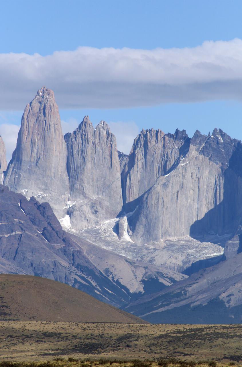
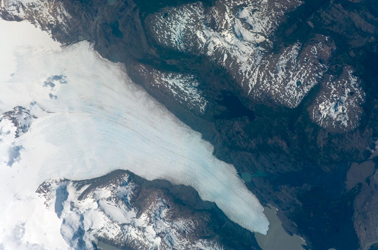
Grinding glaciers and granite peaks mingle in Chile’s Torres del Paine National Park. The Advanced Land Imager (ALI) on NASA’s Earth Observing-1 (EO-1) satellite captured this summertime image of the park on January 21, 2013. This image shows just a portion of the park, including Grey Glacier and the mountain range of Cordillera del Paine. The rivers of glacial ice in Torres del Paine National Park grind over bedrock, turning some of that rock to dust. Many of the glaciers terminate in freshwater lakes, which are rich with glacial flour that colors them brown to turquoise. Skinny rivers connect some of the lakes to each other (image upper and lower right). Cordillera del Paine rises between some of the wide glacial valleys. The compact mountain range is a combination of soaring peaks and small glaciers, most notably the Torres del Paine (Towers of Paine), three closely spaced peaks emblematic of the mountain range and the larger park. By human standards, the mountains of Cordillera del Paine are quite old. But compared to the Rocky Mountains (70 million years old), and the Appalachians (about 480 million years), the Cordillera del Paine are very young—only about 12 million years old. A study published in 2008 described how scientists used zircon crystals to estimate the age of Cordillera del Paine. The authors concluded that the mountain range was built in three pulses, creating a granite laccolith, or dome-shaped feature, more than 2,000 meters (7,000 feet) thick. NASA Earth Observatory image created by Jesse Allen and Robert Simmon, using Advanced Land Imager data from the NASA EO-1 team. Caption by Michon Scott. Instrument: EO-1 - ALI View more info: <a href="http://earthobservatory.nasa.gov/IOTD/view.php?id=80266" rel="nofollow">earthobservatory.nasa.gov/IOTD/view.php?id=80266</a> Credit: <b><a href="http://www.earthobservatory.nasa.gov/" rel="nofollow"> NASA Earth Observatory</a></b> <b><a href="http://www.nasa.gov/audience/formedia/features/MP_Photo_Guidelines.html" rel="nofollow">NASA image use policy.</a></b> <b><a href="http://www.nasa.gov/centers/goddard/home/index.html" rel="nofollow">NASA Goddard Space Flight Center</a></b> enables NASA’s mission through four scientific endeavors: Earth Science, Heliophysics, Solar System Exploration, and Astrophysics. Goddard plays a leading role in NASA’s accomplishments by contributing compelling scientific knowledge to advance the Agency’s mission. <b>Follow us on <a href="http://twitter.com/NASA_GoddardPix" rel="nofollow">Twitter</a></b> <b>Like us on <a href="http://www.facebook.com/pages/Greenbelt-MD/NASA-Goddard/395013845897?ref=tsd" rel="nofollow">Facebook</a></b> <b>Find us on <a href="http://instagrid.me/nasagoddard/?vm=grid" rel="nofollow">Instagram</a></b>
The Cuernos del Paine mountains in Torres del Paine National Park in Chile, photographed during NASA's AirSAR 2004 campaign. AirSAR 2004 is a three-week expedition in Central and South America by an international team of scientists that is using an all-weather imaging tool, called the Airborne Synthetic Aperture Radar (AirSAR), located onboard NASA's DC-8 airborne laboratory. Scientists from many parts of the world are combining ground research with NASA's AirSAR technology to improve and expand on the quality of research they are able to conduct. Founded in 1959, Torres del Paine National Park encompasses 450,000 acres in the Patagonia region of Chile. This region is being studied by NASA using a DC-8 equipped with an Airborne Synthetic Aperture Radar (AirSAR) developed by scientists from NASA’s Jet Propulsion Laboratory. This is a very sensitive region that is important to scientists because the temperature has been consistently rising causing a subsequent melting of the region’s glaciers. AirSAR will provide a baseline model and unprecedented mapping of the region. This data will make it possible to determine whether the warming trend is slowing, continuing or accelerating. AirSAR will also provide reliable information on ice shelf thickness to measure the contribution of the glaciers to sea level.
The Cuernos del Paine mountains in Torres del Paine National Park, Chile, during NASA's AirSAR 2004 campaign. AirSAR 2004 is a three-week expedition in Central and South America by an international team of scientists that is using an all-weather imaging tool, called the Airborne Synthetic Aperture Radar (AirSAR), located onboard NASA's DC-8 airborne laboratory. Scientists from many parts of the world are combining ground research with NASA's AirSAR technology to improve and expand on the quality of research they are able to conduct. Founded in 1959, Torres del Paine National Park encompasses 450,000 acres in the Patagonia region of Chile. This region is being studied by NASA using a DC-8 equipped with an Airborne Synthetic Aperture Radar (AirSAR) developed by scientists from NASA’s Jet Propulsion Laboratory. This is a very sensitive region that is important to scientists because the temperature has been consistently rising causing a subsequent melting of the region’s glaciers. AirSAR will provide a baseline model and unprecedented mapping of the region. This data will make it possible to determine whether the warming trend is slowing, continuing or accelerating. AirSAR will also provide reliable information on ice shelf thickness to measure the contribution of the glaciers to sea level.
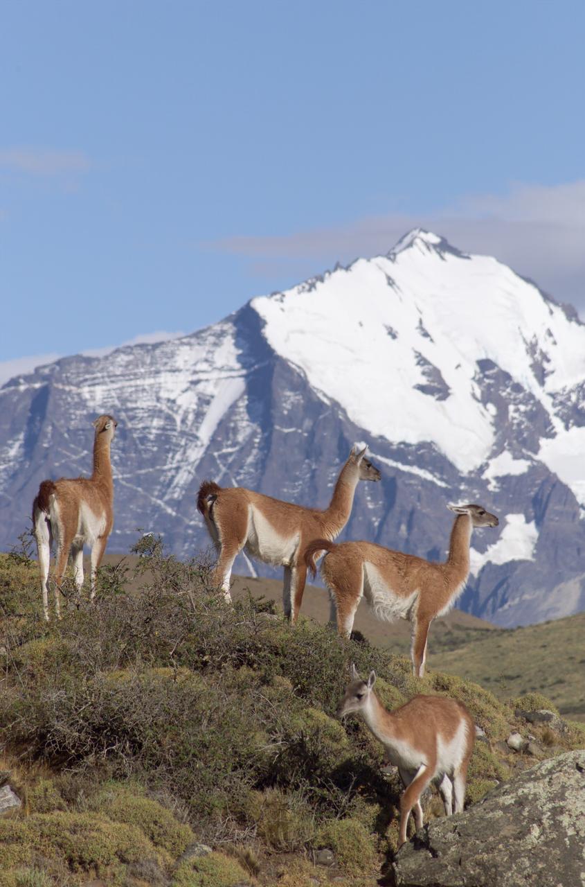
The Cuernos del Paine mountains in Torres del Paine National Park in Chile provide a backdrop to a herd of guanacos during NASA's AirSAR 2004 campaign. AirSAR 2004 is a three-week expedition in Central and South America by an international team of scientists that is using an all-weather imaging tool, called the Airborne Synthetic Aperture Radar (AirSAR), located onboard NASA's DC-8 airborne laboratory. Scientists from many parts of the world are combining ground research with NASA's AirSAR technology to improve and expand on the quality of research they are able to conduct. Founded in 1959, Torres del Paine National Park encompasses 450,000 acres in the Patagonia region of Chile. This region is being studied by NASA using a DC-8 equipped with an Airborne Synthetic Aperture Radar (AirSAR) developed by scientists from NASA’s Jet Propulsion Laboratory. This is a very sensitive region that is important to scientists because the temperature has been consistently rising causing a subsequent melting of the region’s glaciers. AirSAR will provide a baseline model and unprecedented mapping of the region. This data will make it possible to determine whether the warming trend is slowing, continuing or accelerating. AirSAR will also provide reliable information on ice shelf thickness to measure the contribution of the glaciers to sea level.

A fox at Torres del Paine National Park in Chile during NASA's AirSAR 2004 campaign. AirSAR 2004 is a three-week expedition in Central and South America by an international team of scientists that is using an all-weather imaging tool, called the Airborne Synthetic Aperture Radar (AirSAR), located onboard NASA's DC-8 airborne laboratory. Scientists from many parts of the world are combining ground research with NASA's AirSAR technology to improve and expand on the quality of research they are able to conduct. Founded in 1959, Torres del Paine National Park encompasses 450,000 acres in the Patagonia region of Chile. This region is being studied by NASA using a DC-8 equipped with an Airborne Synthetic Aperture Radar (AirSAR) developed by scientists from NASA’s Jet Propulsion Laboratory. This is a very sensitive region that is important to scientists because the temperature has been consistently rising causing a subsequent melting of the region’s glaciers. AirSAR will provide a baseline model and unprecedented mapping of the region. This data will make it possible to determine whether the warming trend is slowing, continuing or accelerating. AirSAR will also provide reliable information on ice shelf thickness to measure the contribution of the glaciers to sea level.
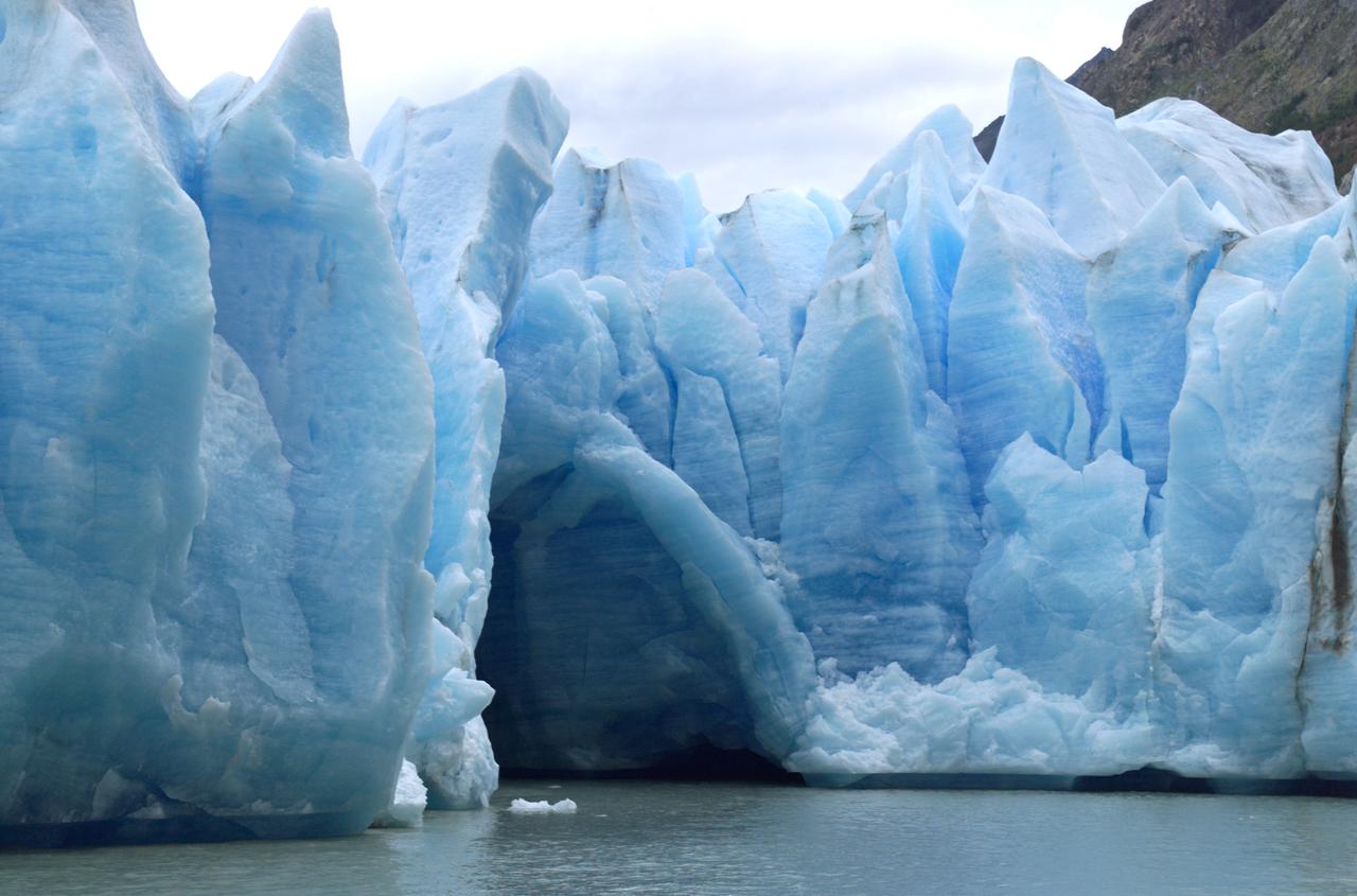
A cave in Glacier Grey in Torres del Paine National Park, seen during NASA's AirSAR 2004 campaign in Chile. AirSAR 2004 is a three-week expedition in Central and South America by an international team of scientists that is using an all-weather imaging tool, called the Airborne Synthetic Aperture Radar (AirSAR), located onboard NASA's DC-8 airborne laboratory. Scientists from many parts of the world are combining ground research with NASA's AirSAR technology to improve and expand on the quality of research they are able to conduct. Founded in 1959, Torres del Paine National Park encompasses 450,000 acres in the Patagonia region of Chile. This region is being studied by NASA using a DC-8 equipped with an Airborne Synthetic Aperture Radar (AirSAR) developed by scientists from NASA’s Jet Propulsion Laboratory. This is a very sensitive region that is important to scientists because the temperature has been consistently rising causing a subsequent melting of the region’s glaciers. AirSAR will provide a baseline model and unprecedented mapping of the region. This data will make it possible to determine whether the warming trend is slowing, continuing or accelerating. AirSAR will also provide reliable information on ice shelf thickness to measure the contribution of the glaciers to sea level.
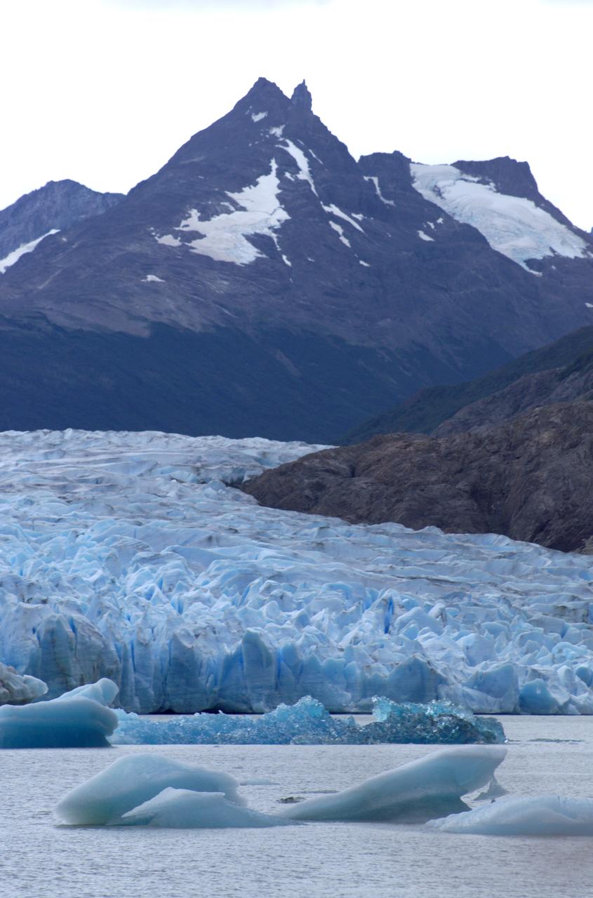
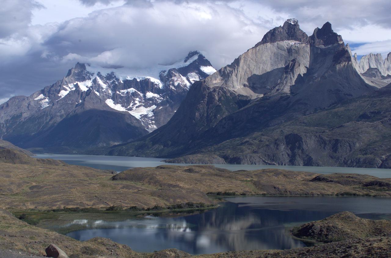
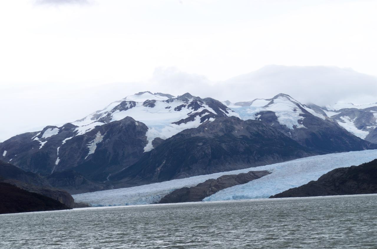
Glacier Grey in front of the Cuernos del Paine mountains, photographed from Lago Grey (Grey Lake) during NASA's AirSAR 2004 campaign in Chile. AirSAR 2004 is a three-week expedition in Central and South America by an international team of scientists that is using an all-weather imaging tool, called the Airborne Synthetic Aperture Radar (AirSAR), located onboard NASA's DC-8 airborne laboratory. Scientists from many parts of the world are combining ground research with NASA's AirSAR technology to improve and expand on the quality of research they are able to conduct. Founded in 1959, Torres del Paine National Park encompasses 450,000 acres in the Patagonia region of Chile. This region is being studied by NASA using a DC-8 equipped with an Airborne Synthetic Aperture Radar (AirSAR) developed by scientists from NASA’s Jet Propulsion Laboratory. This is a very sensitive region that is important to scientists because the temperature has been consistently rising causing a subsequent melting of the region’s glaciers. AirSAR will provide a baseline model and unprecedented mapping of the region. This data will make it possible to determine whether the warming trend is slowing, continuing or accelerating. AirSAR will also provide reliable information on ice shelf thickness to measure the contribution of the glaciers to sea level.
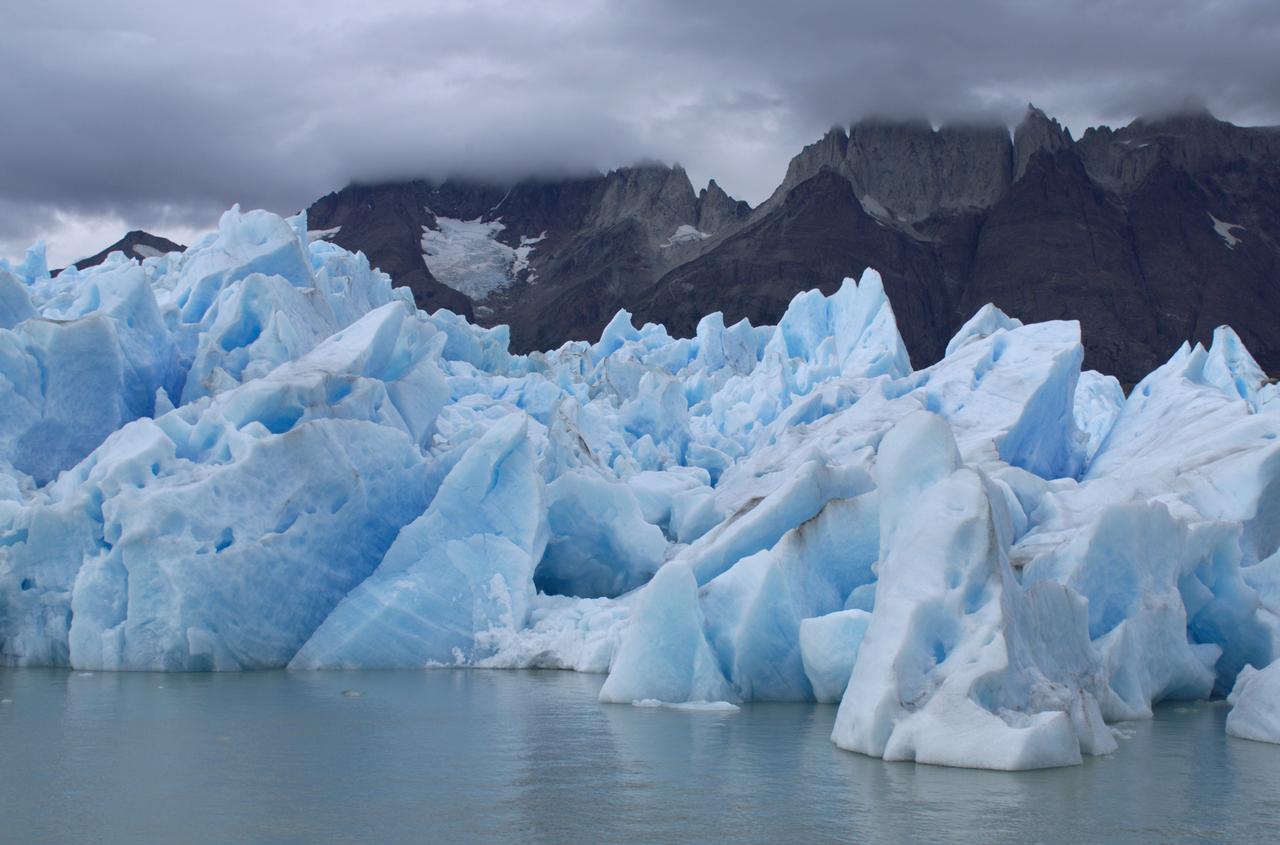
View of Glacier Grey from Lago Grey (Grey Lake), with the Cuernos del Paine mountains in the background, seen during NASA's AirSAR 2004 campaign in Chile. AirSAR 2004 is a three-week expedition in Central and South America by an international team of scientists that is using an all-weather imaging tool, called the Airborne Synthetic Aperture Radar (AirSAR), located onboard NASA's DC-8 airborne laboratory. Scientists from many parts of the world are combining ground research with NASA's AirSAR technology to improve and expand on the quality of research they are able to conduct. Founded in 1959, Torres del Paine National Park encompasses 450,000 acres in the Patagonia region of Chile. This region is being studied by NASA using a DC-8 equipped with an Airborne Synthetic Aperture Radar (AirSAR) developed by scientists from NASA’s Jet Propulsion Laboratory. This is a very sensitive region that is important to scientists because the temperature has been consistently rising causing a subsequent melting of the region’s glaciers. AirSAR will provide a baseline model and unprecedented mapping of the region. This data will make it possible to determine whether the warming trend is slowing, continuing or accelerating. AirSAR will also provide reliable information on ice shelf thickness to measure the contribution of the glaciers to sea level.
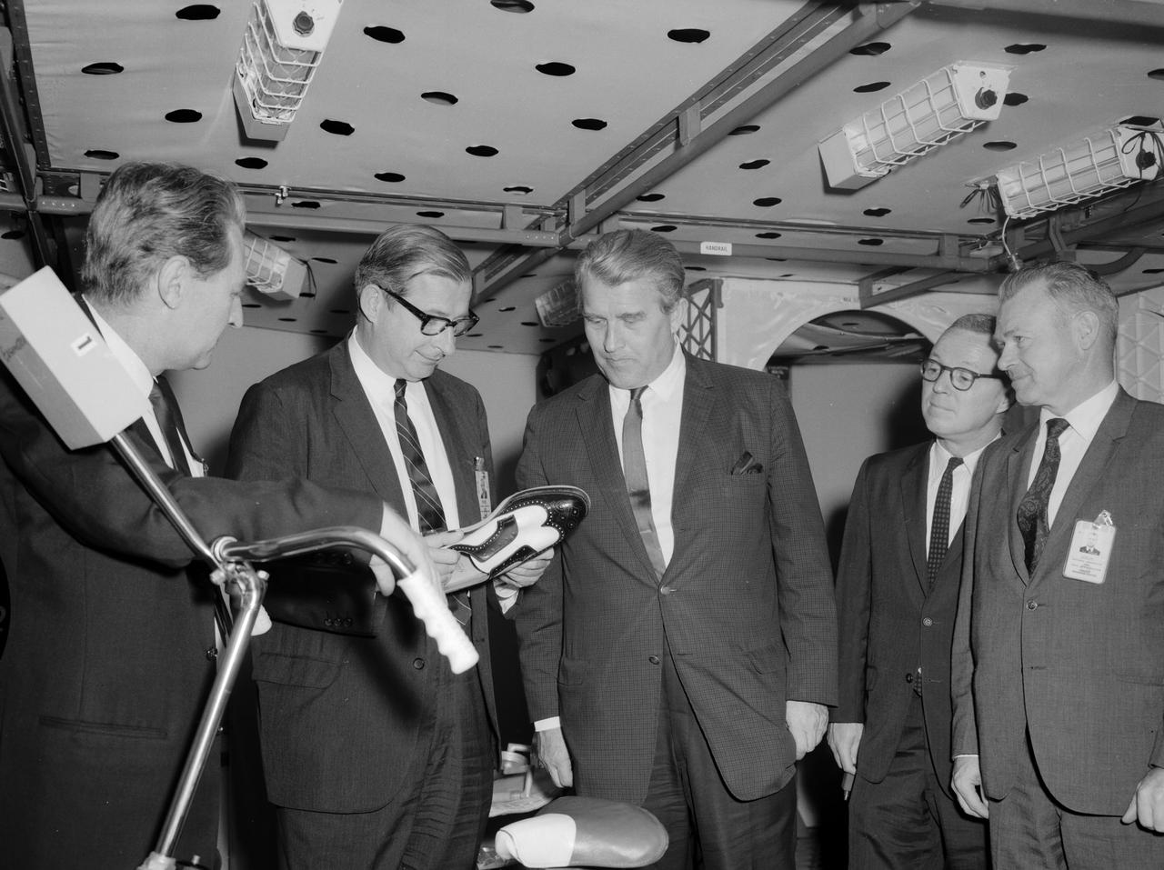
Pictured from the left, in the Saturn I mockup, are: William Brooksbank, Marshall Space Flight Center (MSFC) Propulsion and Vehicle Engineering Laboratory; Dr. Thomas O. Paine, Deputy Administrator of the National Aeronautics and Space Administration (NASA); Dr. Wernher von Braun, MSFC director; Colonel Clare F. Farley, executive officer of the Office of the Administrator; and Charles J. Donlan, newly appointed deputy associate administrator for Manned Space Flight, technical. The party examined an ordinary man’s shoe (held by Paine) outfitted for use in the Saturn I Workshop. The shoe had a unique fastener built into the sole to allow an astronaut to move about the workshop floor and to remain in one position if he desired. Dr. Paine and his party indulged in a two-day tour at the Marshall Space Flight Center getting acquainted with Marshall personnel and programs. It was Paine’s first visit to the center since assuming the NASA post on February 1, 1968.
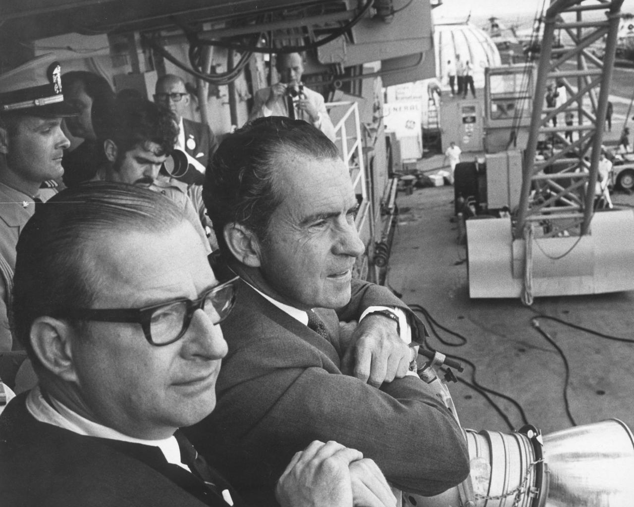
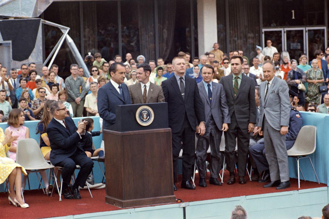
Dr. Thomas Paine, NASA administrator (left) and U.S. President Richard Milhous Nixon wait aboard the recovery ship, the U.S.S. Hornet, for splashdown of the Apollo 11 in the Pacific Ocean. Navy para-rescue men recovered the capsule housing the 3-man crew. The crew was taken to safety aboard the U.S.S. Hornet, where they were quartered in a Mobile Quarantine Facility (MQF). The Apollo 11 mission, the first manned lunar mission, launched from the Kennedy Space Center, Florida via the Saturn V launch vehicle on July 16, 1969 and safely returned to Earth on July 24, 1969. The Saturn V vehicle was developed by the Marshall Space Flight Center (MSFC) under the direction of Dr. Wernher von Braun. Aboard were Neil A. Armstrong, commander; Michael Collins, Command Module (CM) pilot; and Edwin E. Aldrin Jr., Lunar Module (LM) pilot. The CM, piloted by Michael Collins remained in a parking orbit around the Moon while the LM, named “Eagle’’, carrying astronauts Neil Armstrong and Edwin Aldrin, landed on the Moon. Armstrong was the first human to ever stand on the lunar surface, followed by Edwin (Buzz) Aldrin. During 2½ hours of surface exploration, the crew collected 47 pounds of lunar surface material for analysis back on Earth. With the success of Apollo 11, the national objective to land men on the Moon and return them safely to Earth had been accomplished.
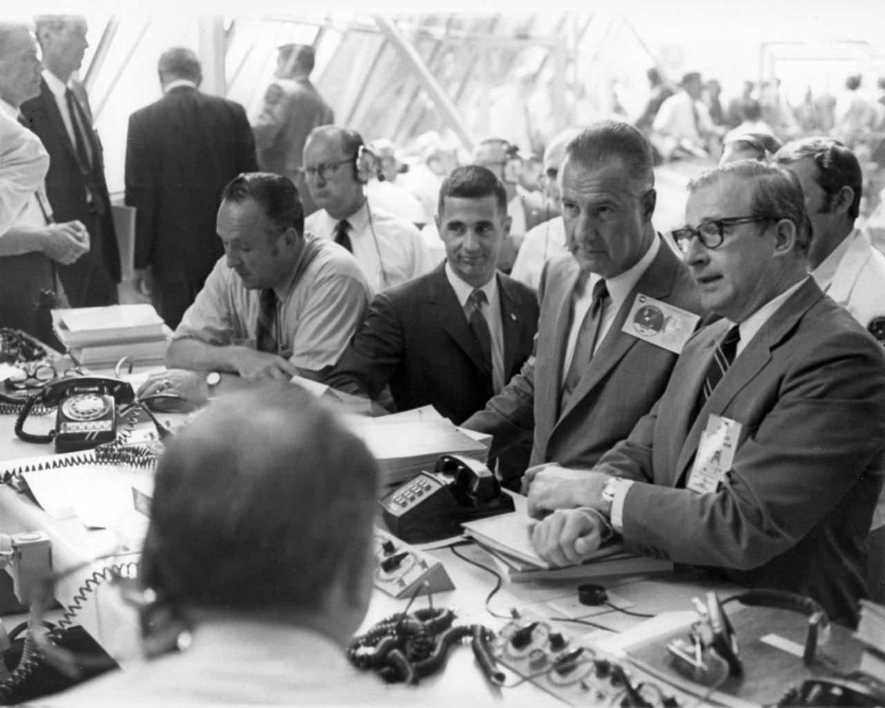
From the right, NASA administrator, Dr. Thomas O. Paine talks with U.S. Vice President Spiro T. Agnew while awaiting the launch of Saturn V (AS-506) that carried the Apollo 11 spacecraft to the Moon for man’s historic first landing on the lunar surface. At center is astronaut William Anders, a member of the first crew to orbit the moon during the Apollo 8 mission. At left is Lee B. James, director of Program Management at the NASA Marshall Space Flight Center (MSFC) where the Saturn V was developed. The craft lifted off from launch pad 39 at Kennedy Space Flight Center (KSC) on July 16, 1969. The moon bound crew included astronauts Neil A. Armstrong, commander; Michael Collins, Command Module (CM) pilot; and Edwin E. Aldrin Jr., Lunar Module (M) pilot. The mission finalized with splashdown in the Pacific Ocean on July 24, 1969. With the success of Apollo 11, the national objective to land men on the Moon and return them safely to Earth had been accomplished.
Glacier Grey view from Lago Grey (Grey Lake), photographed during NASA's AirSAR 2004 campaign in Chile. Land visible in this photo was covered by glacier just 6 years earlier. AirSAR 2004 is a three-week expedition in Central and South America by an international team of scientists that is using an all-weather imaging tool, called the Airborne Synthetic Aperture Radar (AirSAR), located onboard NASA's DC-8 airborne laboratory. Scientists from many parts of the world are combining ground research with NASA's AirSAR technology to improve and expand on the quality of research they are able to conduct. Founded in 1959, Torres del Paine National Park encompasses 450,000 acres in the Patagonia region of Chile. This region is being studied by NASA using a DC-8 equipped with an Airborne Synthetic Aperture Radar (AirSAR) developed by scientists from NASA’s Jet Propulsion Laboratory. This is a very sensitive region that is important to scientists because the temperature has been consistently rising causing a subsequent melting of the region’s glaciers. AirSAR will provide a baseline model and unprecedented mapping of the region. This data will make it possible to determine whether the warming trend is slowing, continuing or accelerating. AirSAR will also provide reliable information on ice shelf thickness to measure the contribution of the glaciers to sea level.

Close-up view of Grey Glacier from Lago Grey (Grey Lake), taken during NASA's AirSAR 2004 campaign in Chile. AirSAR 2004 is a three-week expedition in Central and South America by an international team of scientists that is using an all-weather imaging tool, called the Airborne Synthetic Aperture Radar (AirSAR), located onboard NASA's DC-8 airborne laboratory. Scientists from many parts of the world are combining ground research with NASA's AirSAR technology to improve and expand on the quality of research they are able to conduct. Founded in 1959, Torres del Paine National Park encompasses 450,000 acres in the Patagonia region of Chile. This region is being studied by NASA using a DC-8 equipped with an Airborne Synthetic Aperture Radar (AirSAR) developed by scientists from NASA’s Jet Propulsion Laboratory. This is a very sensitive region that is important to scientists because the temperature has been consistently rising causing a subsequent melting of the region’s glaciers. AirSAR will provide a baseline model and unprecedented mapping of the region. This data will make it possible to determine whether the warming trend is slowing, continuing or accelerating. AirSAR will also provide reliable information on ice shelf thickness to measure the contribution of the glaciers to sea level.

S70-34903 (14 April 1970) --- Dr. Thomas O. Paine, Administrator, National Aeronautics and Space Administration (NASA), talks on the telephone to President Richard M. Nixon. Dr. Paine is seated at his console in the Mission Operations Control Room (MOCR) at the Mission Control Center (MCC), Manned Spacecraft Center (MSC). Also pictured are Dr. Rocco Petrone, Apollo program director, Office Manned Spaceflight, NASA Headquarters (facing camera); and Chester M. Lee, Apollo mission director, Office of Manned Spaceflight, NASA Headquarters (HQ). Dr. Paine and the President were discussing the revised Apollo 13 flight plan following discovery of an oxygen cell failure in the Apollo 13 spacecraft several hours earlier.

S70-34903 (14 April 1970) --- Dr. Thomas O. Paine, Administrator, National Aeronautics and Space Administration (NASA), talks on the telephone to President Richard M. Nixon. Dr. Paine is seated at his console in the Mission Operations Control Room (MOCR) at the Mission Control Center (MCC), Manned Spacecraft Center (MSC). Also pictured are Dr. Rocco Petrone, Apollo program director, Office Manned Spaceflight, NASA Headquarters (facing camera); and Chester M. Lee, Apollo mission director, Office of Manned Spaceflight, NASA Headquarters (HQ). Dr. Paine and the President were discussing the revised Apollo 13 flight plan following discovery of an oxygen cell failure in the Apollo 13 spacecraft several hours earlier.
iss056e096830 (July 15, 2018) --- The mountainous and glacial Torres del Paine National Park in southern Chile is pictured as the International Space Station began a quick orbital pass over the South American continent.
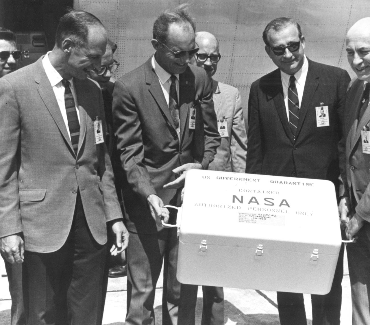
The Apollo 11 mission, the first manned lunar mission, launched from the Kennedy Space Center, Florida via the Marshall Space Flight Center (MSFC) developed Saturn V launch vehicle on July 16, 1969 and safely returned to Earth on July 24, 1969. Aboard the space craft were astronauts Neil A. Armstrong, commander; Michael Collins, Command Module (CM) pilot; and Edwin E. Aldrin Jr., Lunar Module (LM) pilot. The CM, piloted by Michael Collins remained in a parking orbit around the Moon while the LM, named “Eagle’’, carrying astronauts Neil Armstrong and Edwin Aldrin, landed on the Moon. During 2½ hours of surface exploration, the crew collected 47 pounds of lunar surface material for analysis back on Earth. This photograph was taken as the mission’s first loaded sample return container arrived at Ellington Air Force Base by air from the Pacific recovery area. The rock box was immediately taken to the Lunar Receiving Laboratory at the Manned Spacecraft Center (MSC) in Houston, Texas. Happily posing for the photograph with the rock container are (L-R) Richard S. Johnston (back), special assistant to the MSC Director; George M. Low, MSC Apollo Spacecraft Program manager; George S. Trimble (back), MSC Deputy Director; Lt. General Samuel C. Phillips, Apollo Program Director, Office of Manned Spaceflight at NASA headquarters; Eugene G. Edmonds, MSC Photographic Technology Laboratory; Dr. Thomas O. Paine, NASA Administrator; and Dr. Robert R. Gilruth, MSC Director.
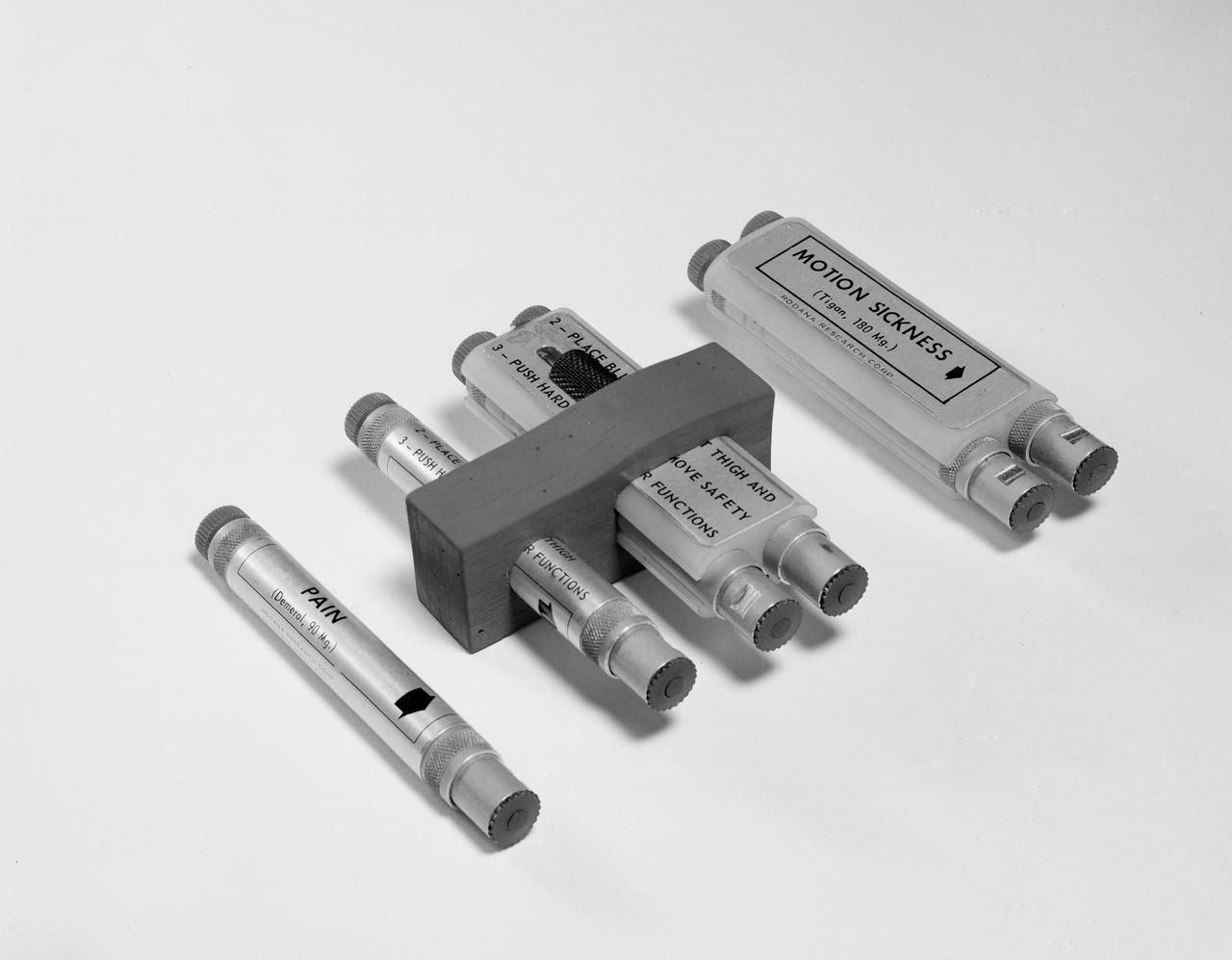
S62-08371 (1962) --- The automatic medical injectors carried on the Mercury-Atlas 9 flight. The injectors provide the astronaut with injection tubes of Tigan, for preventing motion sickness and Demerol, for relieving pain. The tubes encased in the block are stowed in the astronauts survival kit. The single injection tubes are placed in a pocket of the astronauts spacesuit. Photo credit: NASA
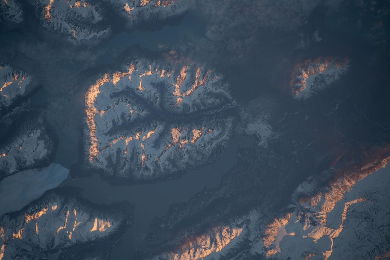
iss056e097055 (July 15, 2018) --- The mountainous and glacial Torres del Paine National Park in the southern-most part of Chile is pictured as the International Space Station began a quick orbital pass over the South American nation from the Pacific Ocean back out over the Atlantic Ocean.
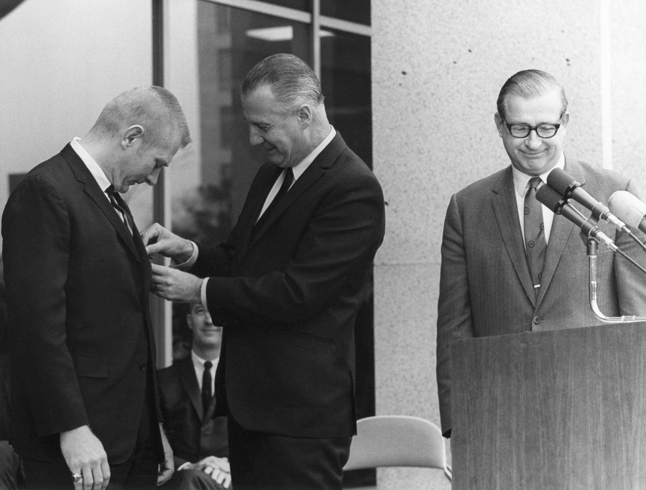
JSC2013-E-009914 (1969) -- Vice President Spiro Agnew pins Flight Director Eugene F. Kranz as NASA Administrator Thomas Paine and Apollo 9 Commander James A. McDivitt look on. Photo credit: NASA Hq. photo identification no. is 69-H-537
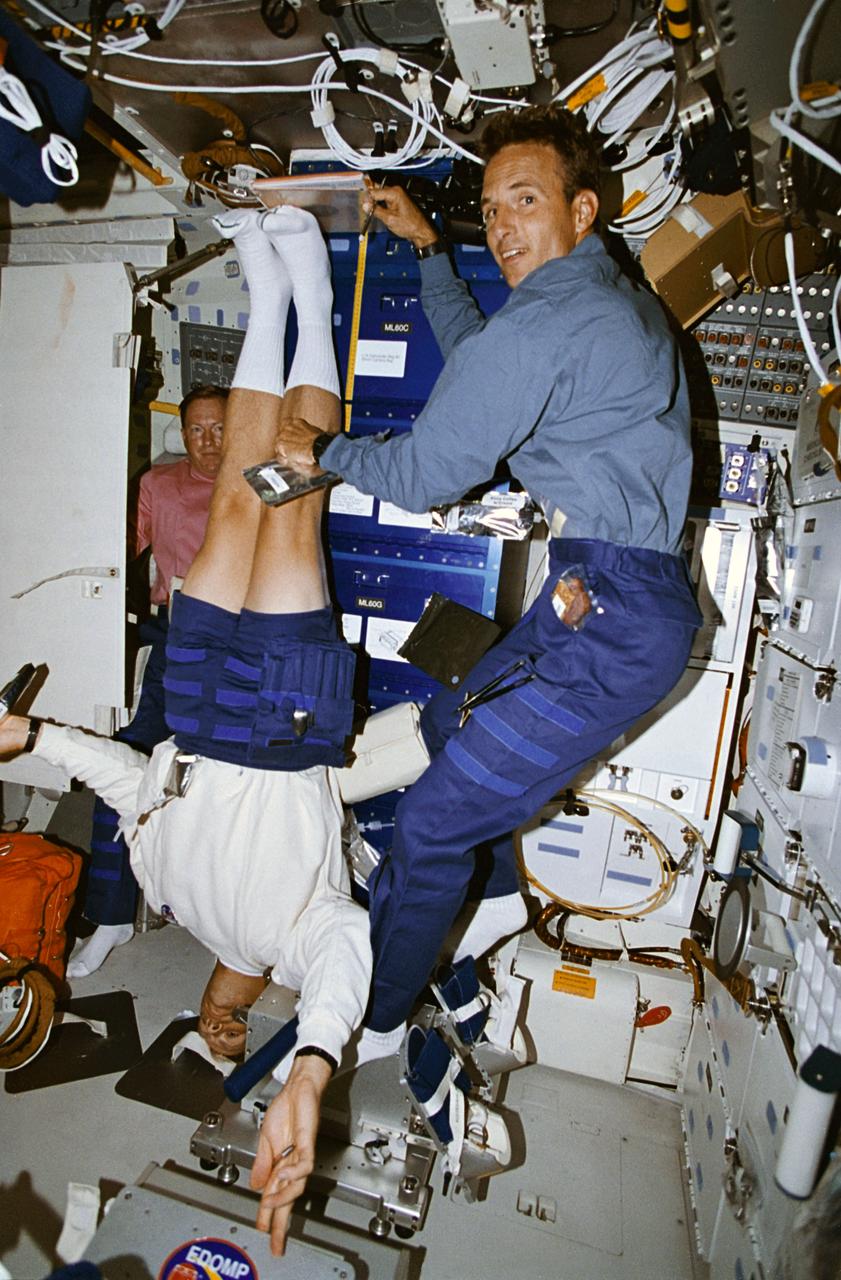
STS064-05-020 (9-20 Sept. 1994) --- Astronaut Mark C. Lee gets his height measured by astronaut Jerry M. Linenger as part of a daily in-flight routine supporting a medical Detailed Supplementary Objective (DSO). Astronaut Richard N. Richards, STS-64 mission commander, looks on in the background. This study was designed to collect information about back pain and height changes experienced by astronauts during flight. Crew members participating in this DSO are required to record height measurements and long back-pain symptoms daily. As an ongoing program, this DSO will gather data from 30 astronauts who spend more than eight consecutive days in space. Photo credit: NASA or National Aeronautics and Space Administration
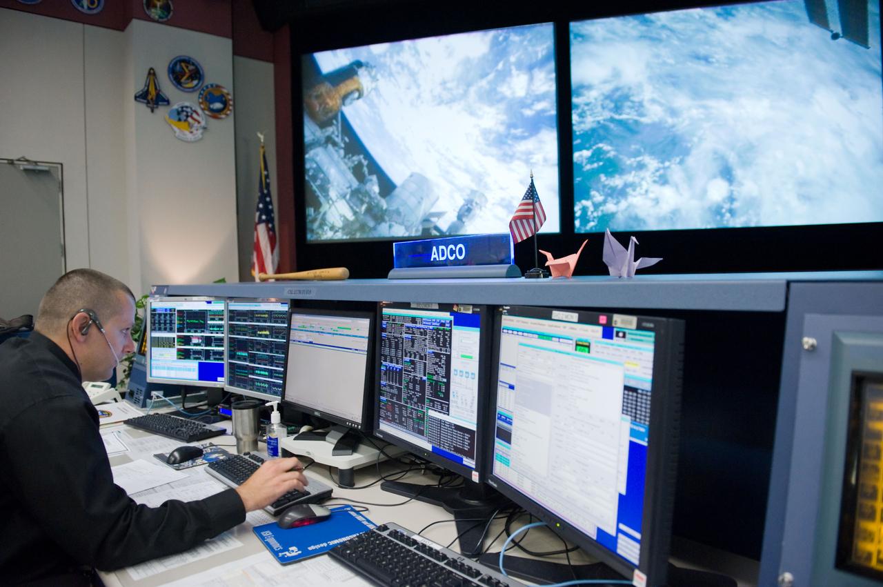
PHOTO DATE: 3-25-11 LOCATION: Bldg. 30M, FCR-1 SUBJECT: JAXA flight control team gave the Folding Paper Cranes to NASA ISS mission control team and now they are decorated on their consoles. The Folding Paper Cranes are for the people who suffer terrible pain from the earthquake in Japan. PHOTOGRAPHER: Lauren Harnett

PHOTO DATE: 3-25-11 LOCATION: Bldg. 30M, FCR-1 SUBJECT: JAXA flight control team gave the Folding Paper Cranes to NASA ISS mission control team and now they are decorated on their consoles. The Folding Paper Cranes are for the people who suffer terrible pain from the earthquake in Japan. PHOTOGRAPHER: Lauren Harnett

CAPE CANAVERAL, Fla. – Kennedy Space Center workers learn about the benefits of foam-rolling exercises and techniques to relieve the strain and pain of overused muscles and connective tissue. The class was part of the National Employee Health and Fitness Day event. Yoga, cardio dance, and boot camp classes were also offered throughout the day at the Operations and Checkout Building's Fitness Center. Photo credit: NASA/ Dimitri Gerondidakis
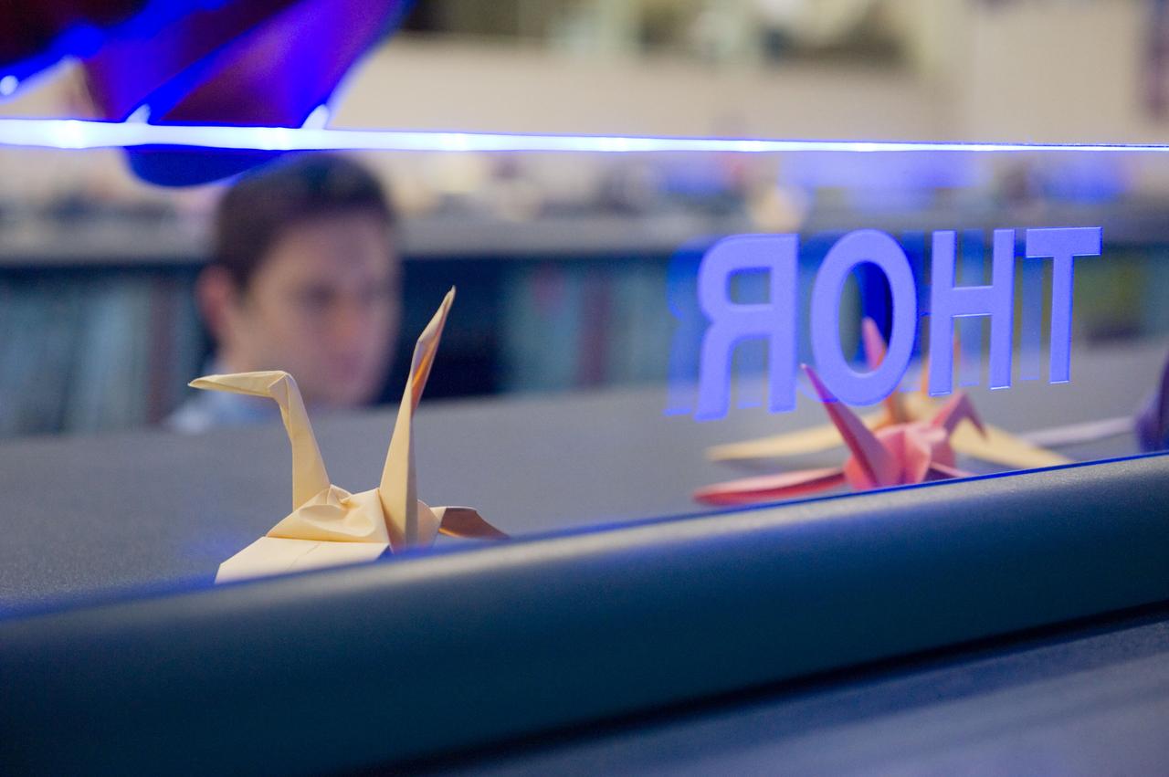
PHOTO DATE: 3-25-11 LOCATION: Bldg. 30M, FCR-1 SUBJECT: JAXA flight control team gave the Folding Paper Cranes to NASA ISS mission control team and now they are decorated on their consoles. The Folding Paper Cranes are for the people who suffer terrible pain from the earthquake in Japan. PHOTOGRAPHER: Lauren Harnett
S70-35600 (18 April 1970) --- President Richard M. Nixon introduces Sigurd A. Sjoberg (far right), director of Flight Operations at Manned Spacecraft Center, and the four Apollo 13 flight directors during the President?s post-mission visit to the Manned Spacecraft Center. The flight directors are, from left to right, Glynn S. Lunney, Eugene A. Kranz, Gerald D. Griffin and Milton L. Windler. Dr. Thomas O. Paine, Administrator, National Aeronautics and Space Administration, is seated at left. President Nixon was on the site to present the Presidential Medal of Freedom - the nation?s highest civilian honor -to the Apollo 13 Mission Operations Team.
ProVision Technologies, a NASA research partnership center at Sternis Space Center in Mississippi, has developed a new hyperspectral imaging (HSI) system that is much smaller than the original large units used aboard remote sensing aircraft and satellites. The new apparatus is about the size of a breadbox. Health-related applications of HSI include non-invasive analysis of human skin to characterize wounds and wound healing rates (especially important for space travelers who heal more slowly), determining if burns are first-, second-, or third degree (rather than painful punch biopsies). The work is sponsored under NASA's Space Product Development (SPD) program.
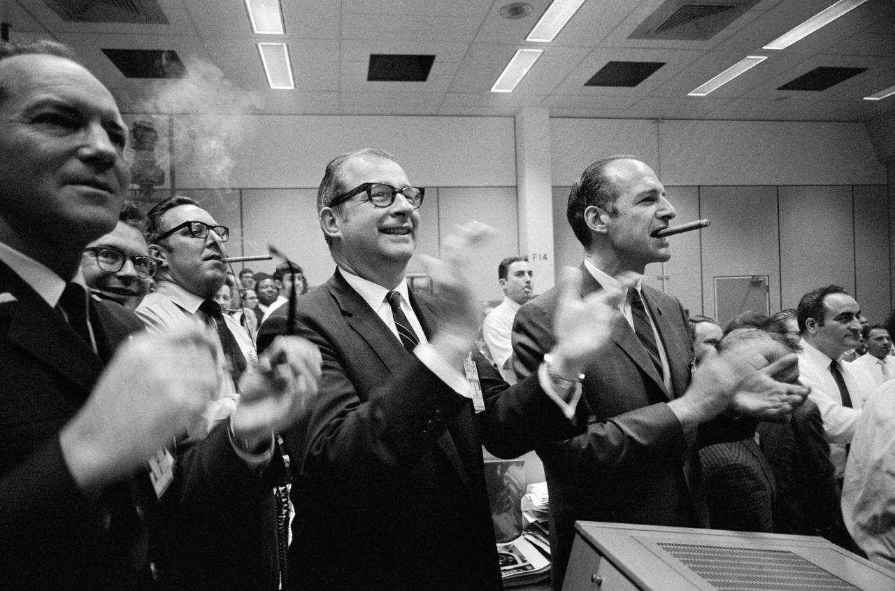
S70-35148 (17 April 1970) --- Staff members from NASA Headquarters (NASA HQ), Manned Spacecraft Center (MSC), and Dr. Thomas Paine (center of frame) applaud the successful splashdown of the Apollo 13 mission while Dr. George Low smokes a cigar (right), in the MSC Mission Control Center (MCC), located in Building 30. Apollo 13 crewmembers, astronauts James A. Lovell Jr., commander; John L. Swigert Jr., command module pilot; and Fred W. Haise Jr., lunar module pilot, splashed down at 12:07:44 p.m. (CST), April 17, 1970, in the south Pacific Ocean.
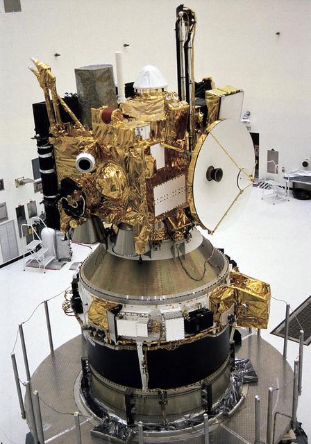
In the Payload Hazardous Servicing Facility, the integrated Mars Observer/Transfer Orbit Stage (TOS) payload is ready for encapsulation in the Titan III nose fairing. The TOS booster maiden flight was dedicated to Thomas O. Paine, a former NASA administrator who strongly supported interplanetary exploration and was an early backer of the TOS program. Launched September 25, 1992 from the Kennedy Space Flight Center aboard a Titan III rocket and the TOS, the Mars Observer spacecraft was to be the first U.S. spacecraft to study Mars since the Viking missions 18 years prior. Unfortunately, the Mars Observer spacecraft fell silent just 3 days prior to entering orbit around Mars.
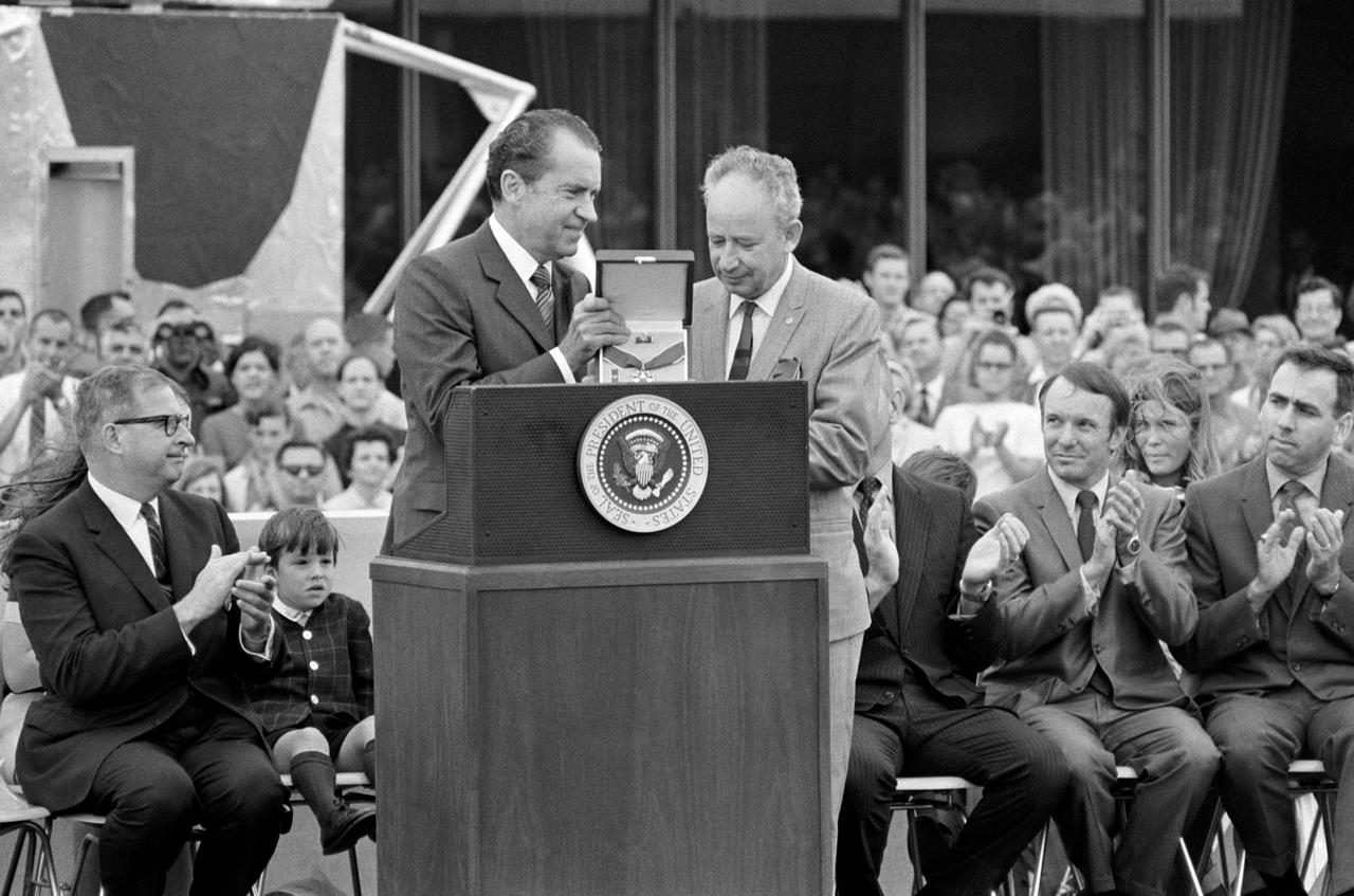
S70-35594 (18 April 1970) --- President Richard M. Nixon presents the Presidential Medal of Freedom to the Apollo 13 Mission Operations Team at Manned Spacecraft Center (MSC). Accepting for the team is Sigurd A. Sjoberg, director of Flight Operations at MSC. Dr. Thomas O. Paine, Administrator, National Aeronautics and Space Administration (NASA), is at left. Also seen here on the speaker's platform are Jeffrey C. Lovell, son of astronaut James A. Lovell Jr., commander of the Apollo 13 mission; Gerald D. Griffin (second from right) and Milton L. Windler, two of four flight directors who worked around the clock during the mission.
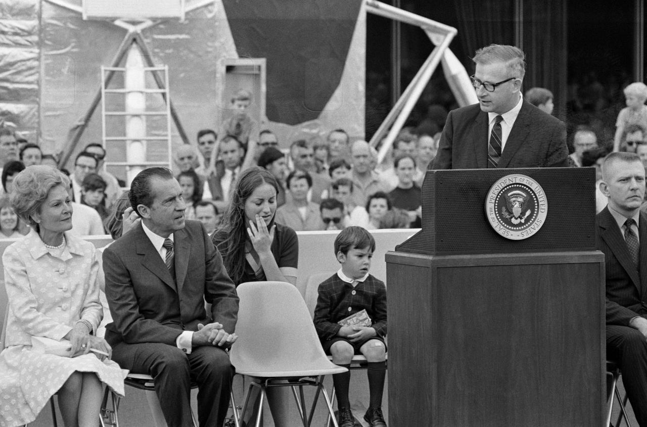
S70-35595 (18 April 1970) --- President Richard M. Nixon is welcomed to Manned Spacecraft Center (MSC) and introduced by Dr. Thomas O. Paine, Administrator, National Aeronautics and Space Administration (NASA). The First Lady is at extreme left. Others on the speakers platform in this view are Barbara and Jeffrey C. Lovell, children of astronaut James A. Lovell Jr., commander; and Eugene F. Kranz (extreme right), one of four flight directors on duty around the clock during the mission. President Nixon was on the site to present the Presidential Medal of Freedom to the Apollo 13 Mission Operations Team.

S70-35148 (17 April 1970) --- Staff members from NASA Headquarters (NASA HQ), Manned Spacecraft Center (MSC), and Dr. Thomas Paine (center of frame) applaud the successful splashdown of the Apollo 13 mission while Dr. George Low smokes a cigar (right), in the MSC Mission Control Center (MCC), located in Building 30. Apollo 13 crewmembers, astronauts James A. Lovell Jr., commander; John L. Swigert Jr., command module pilot; and Fred W. Haise Jr., lunar module pilot, splashed down at 12:07:44 p.m. (CST), April 17, 1970, in the south Pacific Ocean.
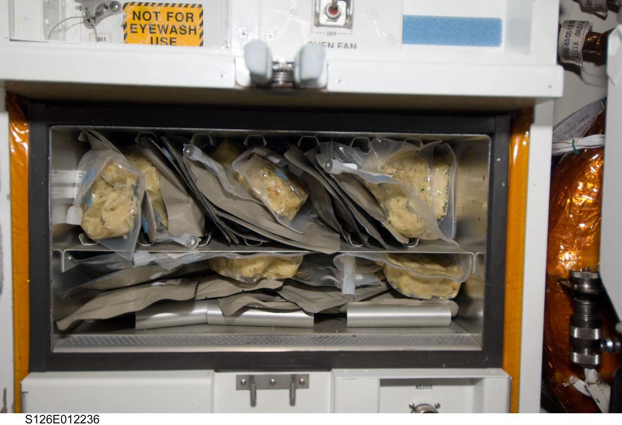
S126-E-12236 (27 Nov. 2008) --- Not far away from this close-up scene of the galley on the Space Shuttle Endeavour were nine astronauts and a cosmonaut eager to share a Thanksgiving meal to top off almost two weeks of joint activities, including an involved home improvement project on the International Space Station. Unlike most of their families and friends on Earth, who probably went through pains to prepare elaborate meals for this festive occasion, the STS-126 and Expedition 18 crewmembers merely needed add water to these prepared packets
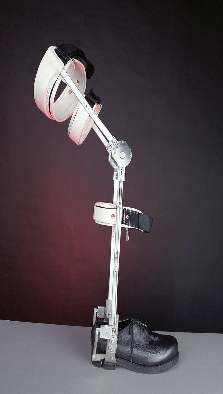
A knee brace that uses Space Shuttle propulsion technology has moved a step closer to being available to help knee injury and stroke patients and may possibly benefit patients with birth defects, spinal cord injuries, and post-polio conditions. After years of hard work, inventors at NASA's Marshall Space Flight Center (MSFC) in Huntsville, Alabama, have turned over the final design and prototype to industry partners at Horton's Orthotic Lab in Little Rock, Arkansas for further clinical testing. The device, called the Selectively Lockable Knee Brace, may mean faster, less painful rehabilitation for patients by allowing the knee to move when weight is not on the heel. Devices currently on the market lock the knee in a rigid, straight-leg position, or allow continuous free motion. The knee brace is just one example of how space technology is being used to improve the lives of people on Earth. NASA's MSFC inventors Michael Shadoan and Neill Myers are space propulsion engineers who use the same mechanisms and materials to build systems for rockets that they used to design and develop the knee brace.
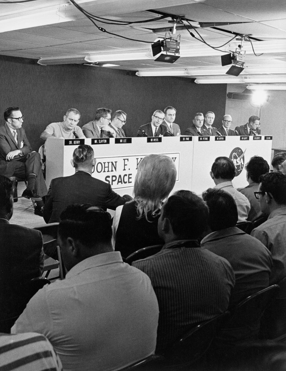
S70-36782 (10 April 1970) --- Several NASA and military officials (background at dais) meet the press on April 10, 1970, during a scheduled a T-1 prelaunch briefing for the Apollo 13 mission in the Apollo News Center at the Kennedy Space Center. The briefing participants, from the left, are Dr. Charles A. Berry, Director, Medical Research and Operations Directorate, Manned Spacecraft Center (MSC); Dr. Donald K. (Deke) Slayton, director of flight crew operations, MSC; Chester M. Lee of the Apollo Program Directorate, Office Manned Space Flight (OMSF),NASA Hq. and Apollo 13 Mission Director; Dale Myers, Associate Administrator, OMSF,NASA Hq.; Dr. Thomas O. Paine, NASA Administrator; Dr. Rocco A. Petrone, Apollo Program Director, OMSF,NASA Hq.; Walter J. Kapryan, NASA's Director of Launch Operations; James A. McDivitt, Manager of the Apollo Spacecraft Program Office; Roy E. Godfrey, Manager, Saturn Program Office; and Col. Kenneth J. Mask, USAF, DOD Manned Space Flight Support Office. Photo credit: NASA
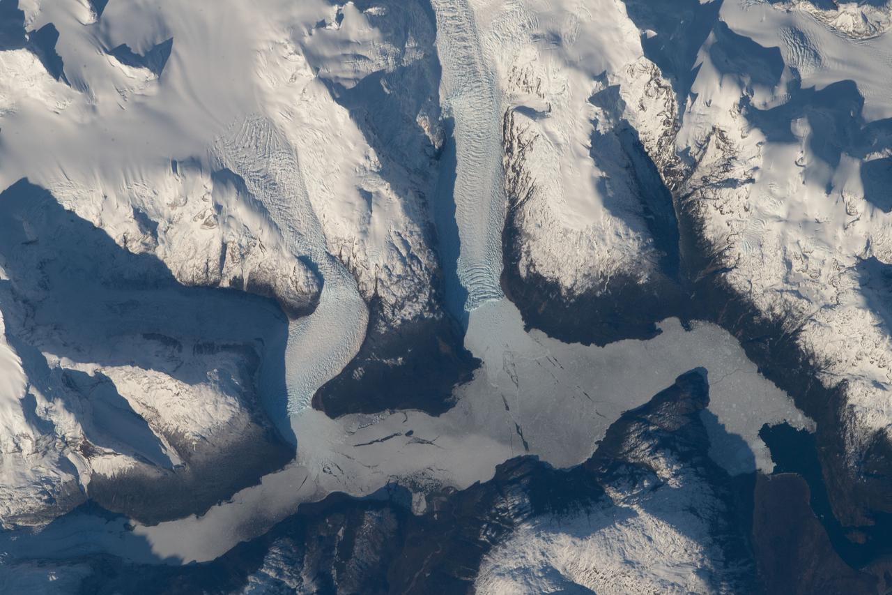
ISS016-E-012047 (22 Nov. 2007) --- Tyndall Glacier, located in the Torres del Paine National Park in Chile, is featured in this image photographed by an Expedition 16 crewmember on the International Space Station. This glacier, which has a measured total area of 331 square kilometers and length of 32 kilometers (1996 measurements), begins in the Patagonian Andes Mountains to the west and terminates in Lago Geikie. A medial moraine is visible in the center of the glacier, extending along its length (center left). These accumulations of soil and rock debris form along the edges of a glacier as it flows downhill across the landscape (much like a snowplow builds ridges of snow along the roadside). Glaciers flowing downslope through adjacent feeder valleys merge when they encounter each other, and debris entrained along their sides becomes concentrated in the central portion of the new combined ice mass -- much as small streams join to form a river. Crevasse fields are also visible in the image. The crevasses -- small, but potentially quite deep fissures -- form as a result of stress between slower- and faster-moving ice within the glacier. Crevasse fields on Tyndall Glacier are most evident near rock promontories extending into the glacier -- causing the ice to slow as it flows around the obstruction.

A knee brace that uses Space Shuttle propulsion technology has moved a step closer to being available to help knee injury and stroke patients and may possibly benefit patients with birth defects, spinal cord injuries, and post-polio conditions. After years of hard work, inventors at NASA's Marshall Space Flight Center (MSFC) in Huntsville, Alabama, have turned over the final design and prototype to industry partners at Horton's Orthotic Lab in Little Rock, Arkansas for further clinical testing. The device, called the Selectively Lockable Knee Brace, may mean faster, less painful rehabilitation for patients by allowing the knee to move when weight is not on the heel. Devices currently on the market lock the knee in a rigid, straight-leg position, or allow continuous free motion. Pictured here is a knee brace prototype being tested and fitted at Horton's Orthotic Lab. The knee brace is just one example of how space technology is being used to improve the lives of people on Earth. NASA's MSFC inventors Michael Shadoan and Neill Myers are space propulsion engineers who use the same mechanisms and materials to build systems for rockets that they used to design and develop the knee brace.
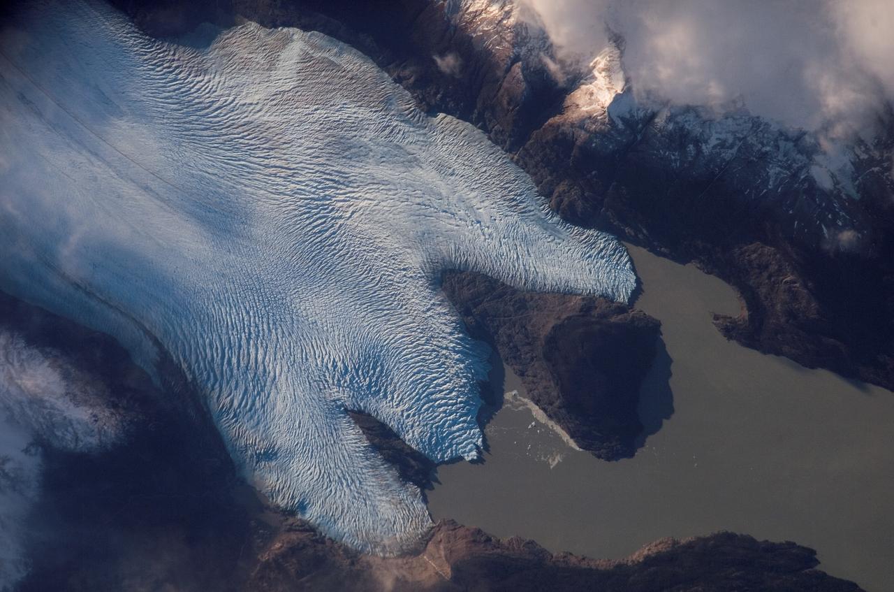
ISS015-E-10699 (4 June 2007) --- Grey Glacier is featured in this image photographed by an Expedition 15 crewmember on the International Space Station. The Southern Patagonian ice field of Chile and Argentina hosts several spectacular glaciers -- including Grey Glacier located in the Torres del Paine National Park in Chile. This glacier, which has a measured total area of 270 square kilometers and length of 28 kilometers (1996 measurements), begins in the Patagonian Andes Mountains to the west and terminates in three distinct lobes into Grey Lake. This view captures a striking blue coloration of the glacier -- this is due to absorption of visible red wavelengths, and scattering of light in the blue wavelengths as it is transmitted through the ice. Certain portions of the glacier visible in the image are indeed grey. Linear grey-brown moraines are accumulations of soil and rock debris that form along the edges of a glacier as it flows downhill across the landscape (much like a bulldozer blade). Glaciers flowing down-slope through adjacent feeder valleys ultimately meet, and debris entrained along their sides becomes concentrated in the central portion of the resulting single large glacier -- much as smaller streams of water join to form a single large river. Three of these medial moraines are visible in the ice mass at center left. Grey-brown patches of debris from adjacent mountainsides color the surface of the easternmost lobe of the glacier (top). Several crevasse fields are visible in the image. The crevasses -- each a small canyon in the ice - form as a result of stress between the slower- and faster-moving ice within the glacier. The crevasse patterns of Grey Glacier are complex, perhaps due to the three-lobed nature of its terminus, or end, into Grey Lake. The rugged surface of the glacier is also demonstrated by the jagged shadows cast onto the surface of the lake.
NPP is lowered into the thermal vacuum chamber. Once inside the Iron Maiden (visible in the lower left) is fitted in place. Then air is pumped out of the chamber and temperature extremes are applied to replicate orbit conditions. Credit: Ball Aerospace The NPP satellite sits surrounded by 144 rock concert speakers. They're stacked in a circle 16 feet high in a testing room at Ball Aerospace in Boulder, Colorado. As engineers set up for the environmental test, Pink Floyd's song "Money" plays gently in the background. The music stops. The room clears. Then the sound engineer wearing earplugs and headphones in the control room next door flips a switch. Slowly, the noise of thousands of pounds of exploding rocket fuel builds louder and louder until it blasts the satellite at a deafening 143.6 decibels -- loud enough to cause serious damage and pain to unprotected ears. "I was outside the building when they did the full level acoustics," says Glenn Iona, NPP Chief Engineer at NASA Goddard Space Flight Center, Greenbelt, Md. "and I could feel the ground shaking." To read more go to: <a href="http://www.nasa.gov/mission_pages/NPP/news/npp-testing.html" rel="nofollow">www.nasa.gov/mission_pages/NPP/news/npp-testing.html</a> <b><a href="http://www.nasa.gov/centers/goddard/home/index.html" rel="nofollow">NASA Goddard Space Flight Center</a></b> enables NASA’s mission through four scientific endeavors: Earth Science, Heliophysics, Solar System Exploration, and Astrophysics. Goddard plays a leading role in NASA’s accomplishments by contributing compelling scientific knowledge to advance the Agency’s mission. <b>Follow us on <a href="http://twitter.com/NASA_GoddardPix" rel="nofollow">Twitter</a></b> <b>Like us on <a href="http://www.facebook.com/pages/Greenbelt-MD/NASA-Goddard/395013845897?ref=tsd" rel="nofollow">Facebook</a></b> <b>Find us on <a href="http://web.stagram.com/n/nasagoddard/?vm=grid" rel="nofollow">Instagram</a></b>