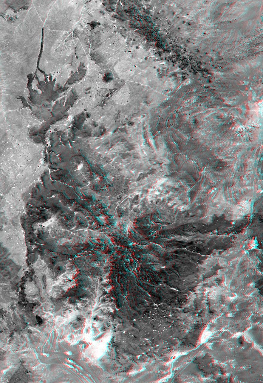
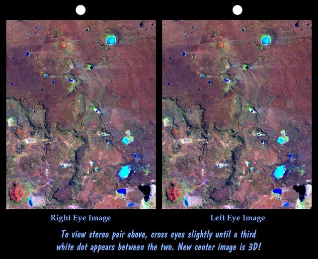
This anaglyph, from NASA Shuttle Radar Topography Mission, shows elatively young volcanoes in northern Patagonia, at Los Menucos, Argentina. 3D glasses are necessary to view this image.
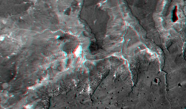
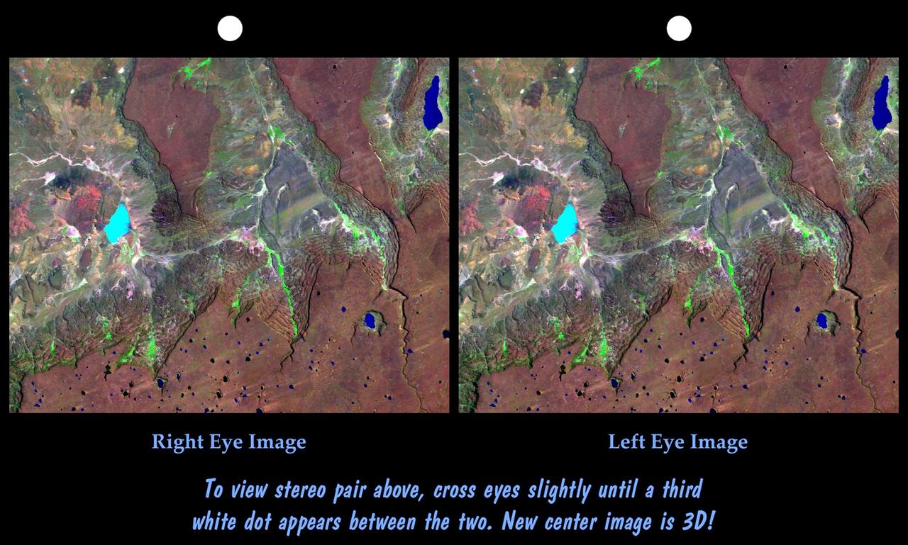
This view of northern Patagonia, near El Cain, Argentina shows complexly eroded volcanic terrain, with basalt mesas, sinkholes, landslide debris, playas, and relatively few integrated drainage channels.
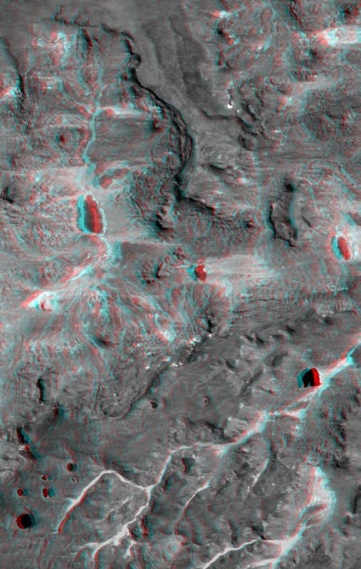
This anaglyph, from NASA Shuttle Radar Topography Mission, shows complexly eroded volcanic terrain in northern Patagonia, near El Cain, Argentina. 3D glasses are necessary to view this image.
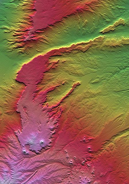
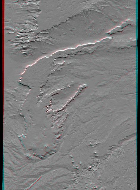
This view of northern Patagonia, at Los Menucos, Argentina shows remnants of relatively young volcanoes built upon an eroded plain of much older and contorted volcanic, granitic, and sedimentary rocks.
This topographic image acquired by NASA Shuttle Radar Topography Mission SRTM from data collected on February 15, 2000, of Patagonia, Argentina shows a spectacular landscape formed by volcanoes, rivers, and wind.
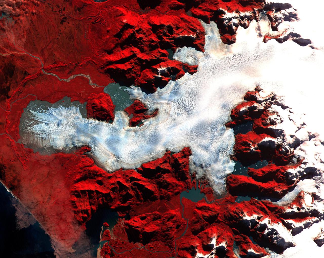
This ASTER image was acquired on May 2, 2000 over the North Patagonia Ice Sheet, Chile near latitude 47 degrees south, longitude 73 degrees west. The image covers 36 x 30 km. The false color composite displays vegetation in red. The image dramatically shows a single large glacier, covered with crevasses. A semi-circular terminal moraine indicates that the glacier was once more extensive than at present. ASTER data are being acquired over hundreds of glaciers worldwide to measure their changes over time. Since glaciers are sensitive indicators of warming or cooling, this program can provide global data set critical to understand climate change. This image is located at 46.5 degrees south latitude and 73.9 degrees west longitude. http://photojournal.jpl.nasa.gov/catalog/PIA02670

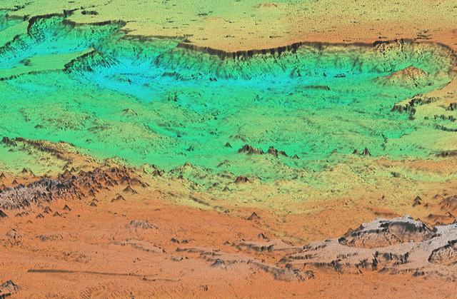
This anaglyph, from NASA Shuttle Radar Topography Mission, shows Meseta de Somuncura, a semi-arid basalt plateau in northern Patagonia. 3D glasses are necessary to view this image.
This perspective view acquired by NASA Shuttle Radar Topography Mission SRTM from data collected in the year 2000 shows Patagonia, Argentina, a spectacular landscape formed by volcanoes, rivers, and wind.
The Meseta de Somuncura is a semi-arid basalt plateau in northern Patagonia. This view of the northwestern part of the plateau, near Los Menucos, Argentina, shows numerous depressions where the upper basalt layers are missing or collapsed.
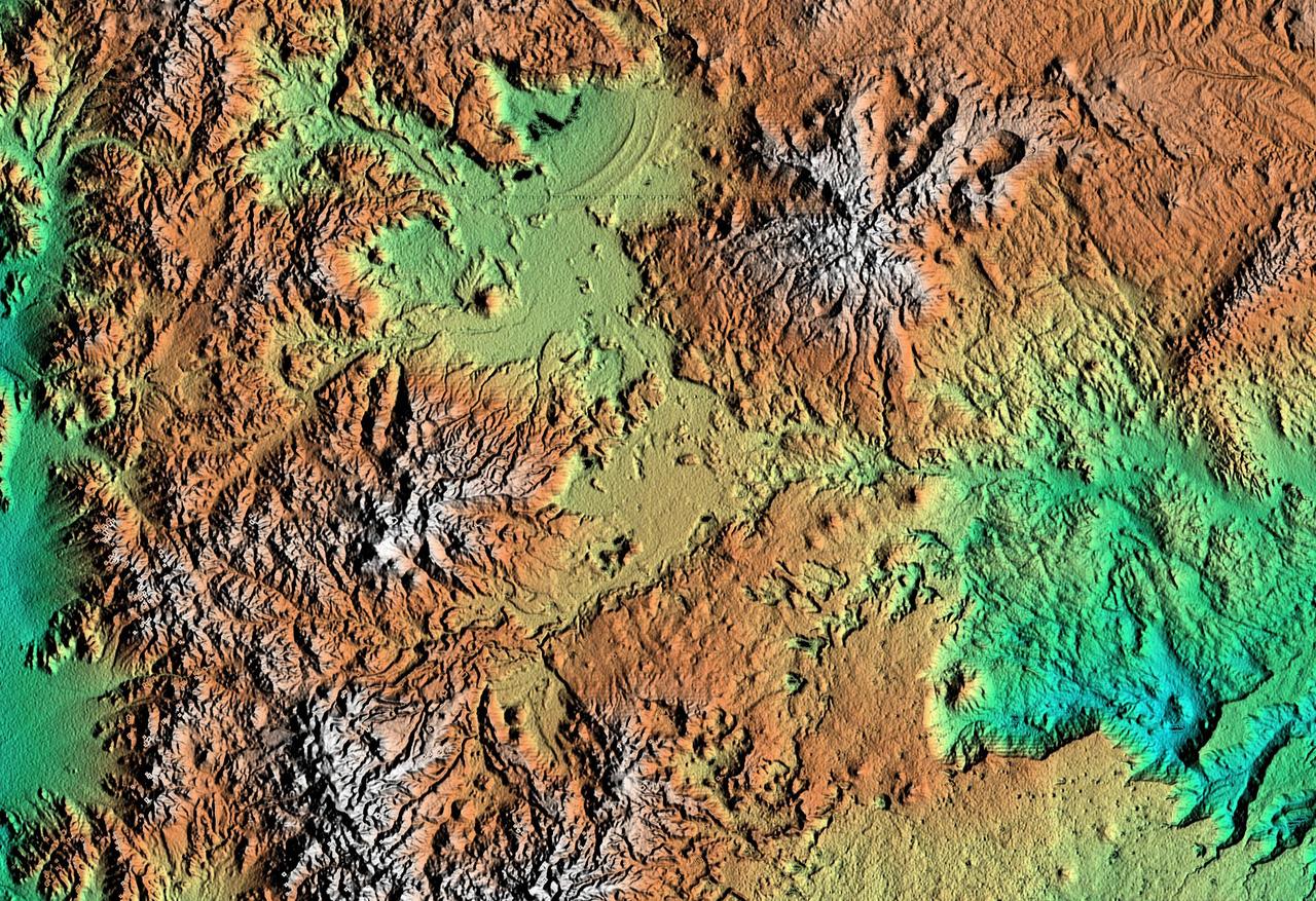
All of the major landforms relate to volcanism and/or erosion in this Shuttle Radar Topography Mission scene of Patagonia, near La Esperanza, Argentina.
This anaglyph, from NASA Shuttle Radar Topography Mission, is of Patagonia, near La Esperanza, Argentina. 3D glasses are necessary to view this image.

GMT013_21_50_Terry Virts_maybe Patagonia zoom_129C
Earth observation taken during a day pass by the Expedition 40 crew aboard the International Space Station. File identifies it as: Patagonia.

Earth observation taken during a day pass by the Expedition 40 crew aboard the International Space Station. File identifies it as: Patagonia.
Earth Observations taken by Expedition 38 crewmember. Photographer indicates Patagonia. Image was released by astronaut on Twitter.
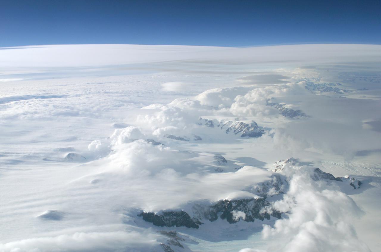
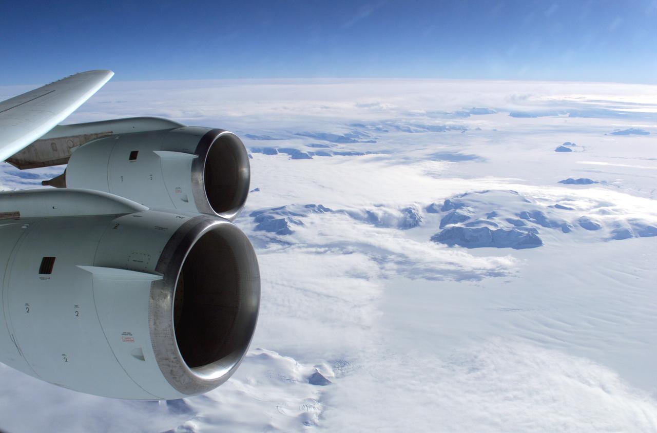
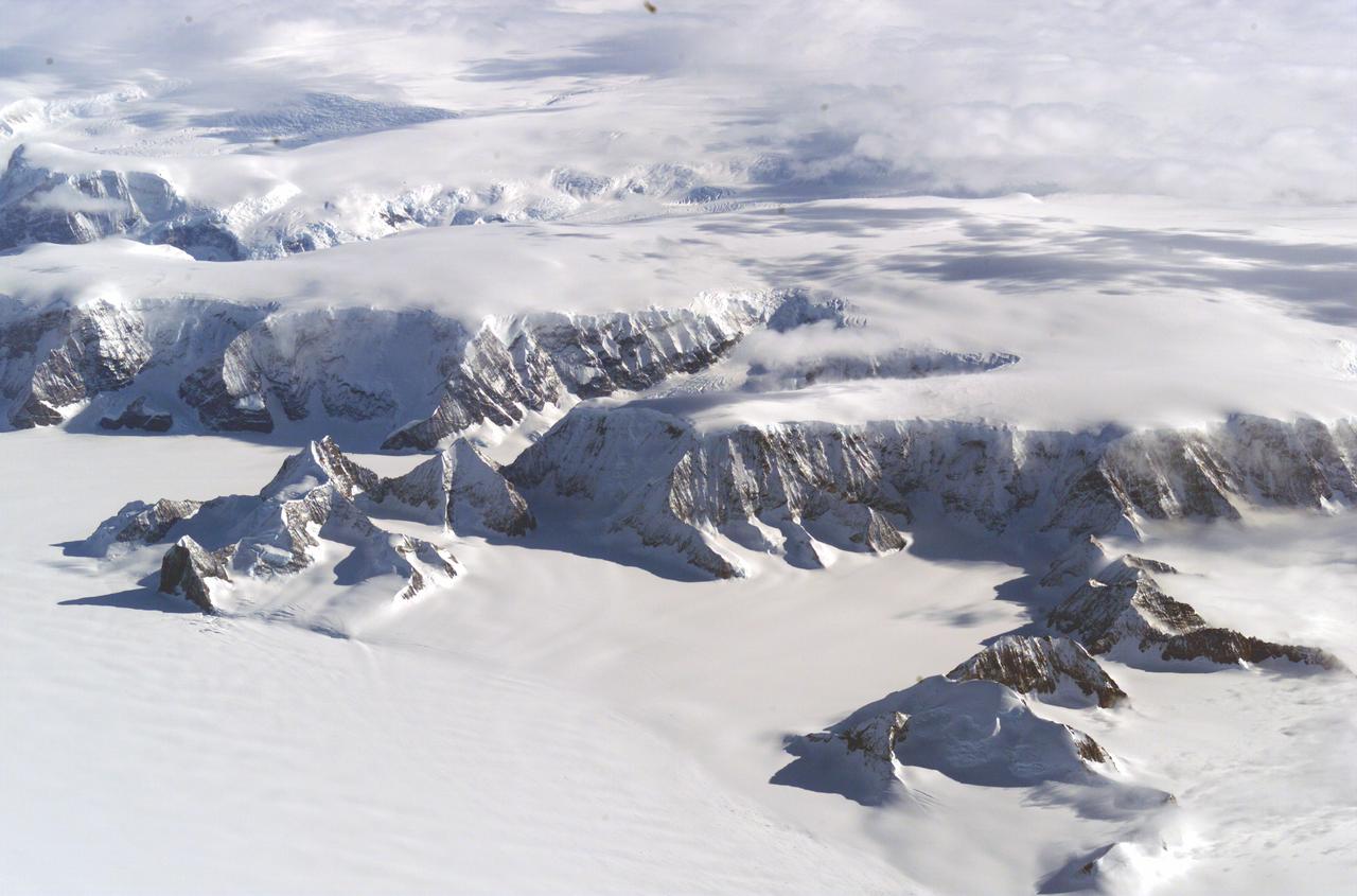
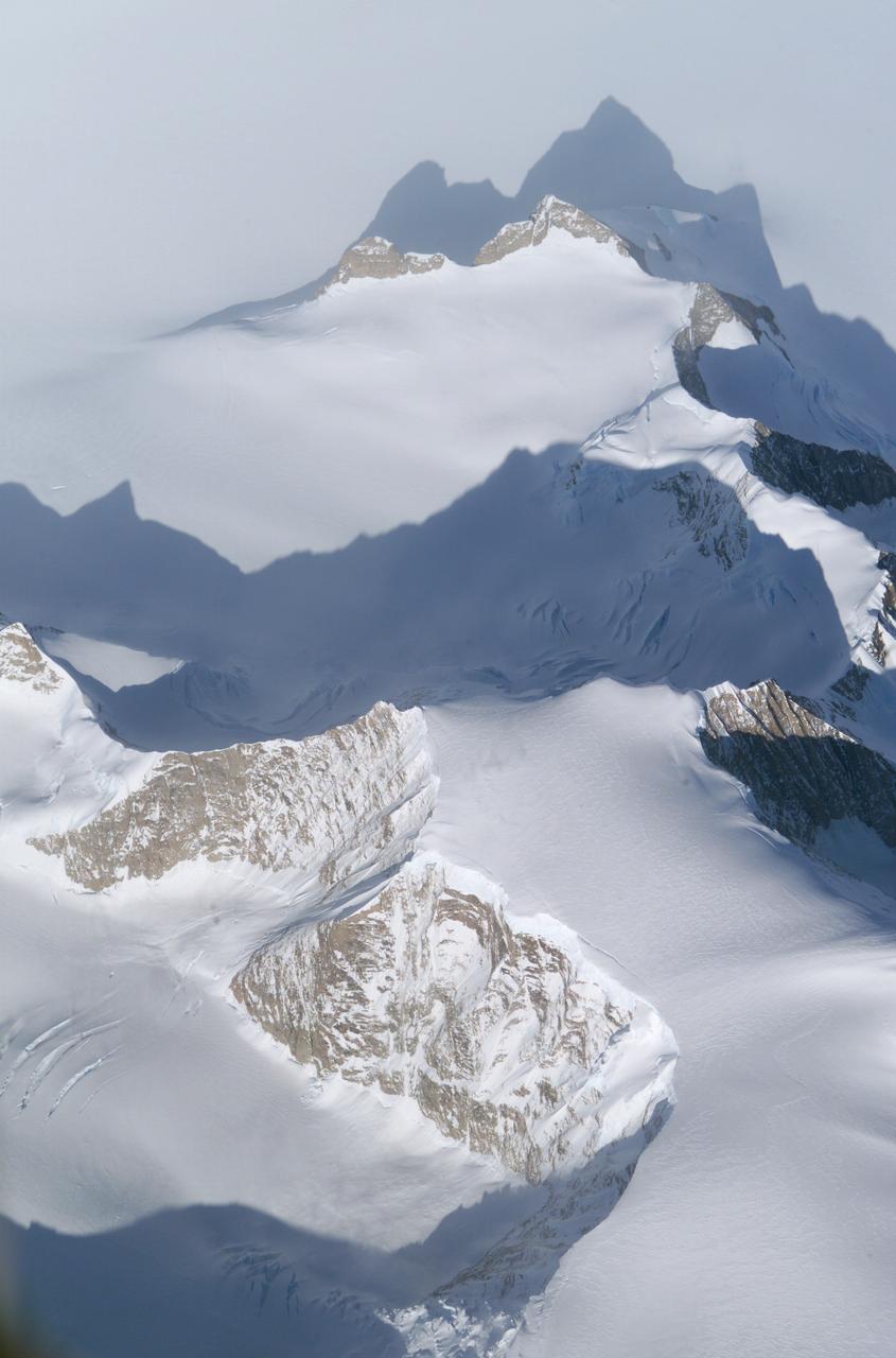
The Larsen Ice Shelf in Antarctica viewed from NASA's DC-8 aircraft during the AirSAR 2004 campaign. AirSAR 2004 is a three-week expedition in Central and South America by an international team of scientists that is using an all-weather imaging tool, called the Airborne Synthetic Aperture Radar (AirSAR), located onboard NASA's DC-8 airborne laboratory. Scientists from many parts of the world are combining ground research with NASA's AirSAR technology to improve and expand on the quality of research they are able to conduct. These photos are from the DC-8 aircraft while flying an AirSAR mission over Antarctica. The Antarctic Peninsula is more similar to Alaska and Patagonia than to the rest of the Antarctic continent. It is drained by fast glaciers, receives abundant precipitation, and melts significantly in the summer months. In recent decades, the Peninsula has experienced significant atmospheric warming (about 2 degrees C since 1950), which has triggered a vast and spectacular retreat of its floating ice shelves, glacier reduction, a decrease in permanent snow cover and a lengthening of the melt season. As a result, the contribution to sea level from this region could be rapid and substantial. With an area of 120,000 km, or ten times the Patagonia ice fields, the Peninsula could contribute as much as 0.4mm/yr sea level rise, which would be the largest single contribution to sea level from anywhere in the world. This region is being studied by NASA using a DC-8 equipped with the Airborne Synthetic Aperture Radar developed by scientists from NASA’s Jet Propulsion Laboratory. AirSAR will provide a baseline model and unprecedented mapping of the region. This data will make it possible to determine whether the warming trend is slowing, continuing or accelerating. AirSAR will also provide reliable information on ice shelf thickness to measure the contribution of the glaciers to sea level.

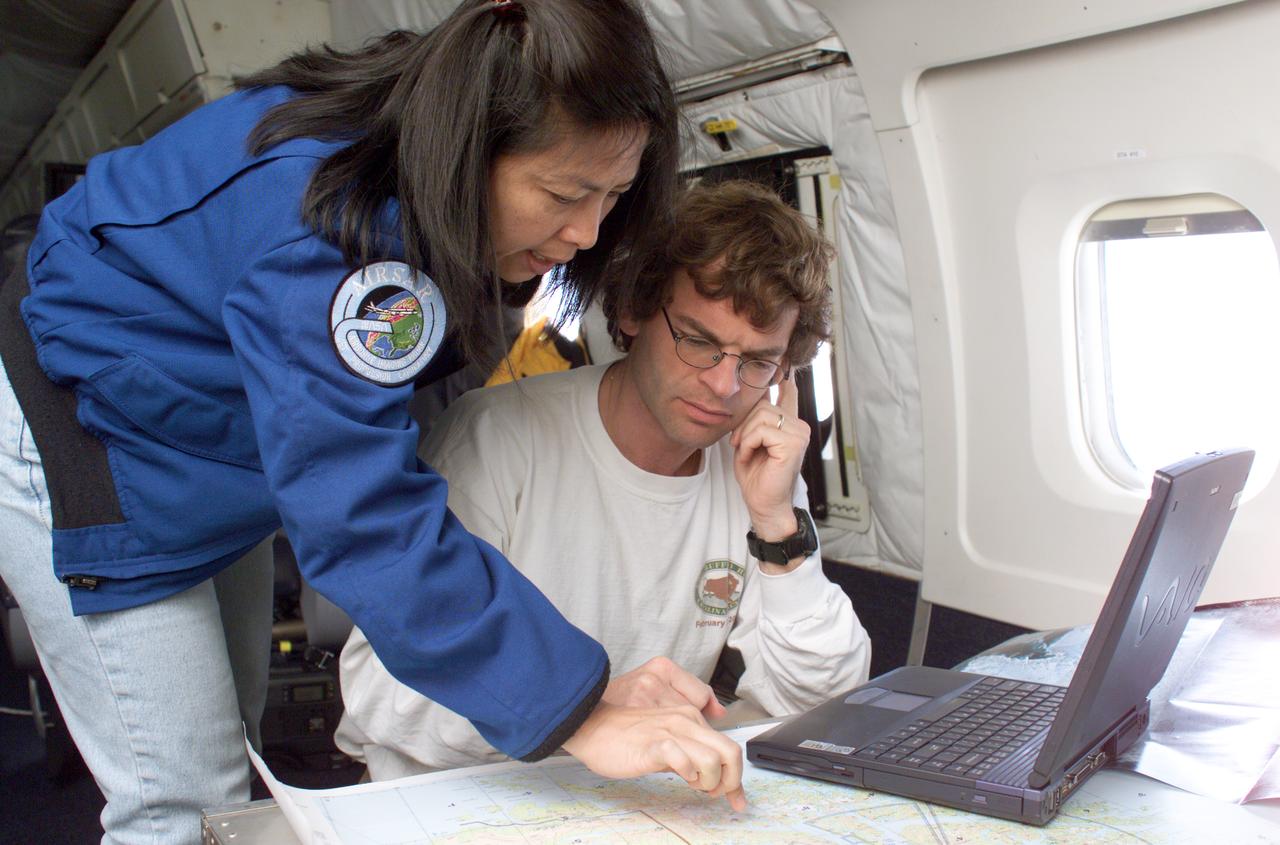
NASA DC-8 Mission Manager Walter Klein and Chilean Air Force Advisor Captain Saez review maps of the Antarctic Peninsula during an AirSAR 2004 mission. AirSAR 2004 is a three-week expedition in Central and South America by an international team of scientists that is using an all-weather imaging tool, called the Airborne Synthetic Aperture Radar (AirSAR), located onboard NASA's DC-8 airborne laboratory. Scientists from many parts of the world are combining ground research with NASA's AirSAR technology to improve and expand on the quality of research they are able to conduct. These photos are from the DC-8 aircraft while flying an AirSAR mission over Antarctica. The Antarctic Peninsula is more similar to Alaska and Patagonia than to the rest of the Antarctic continent. It is drained by fast glaciers, receives abundant precipitation, and melts significantly in the summer months. In recent decades, the Peninsula has experienced significant atmospheric warming (about 2 degrees C since 1950), which has triggered a vast and spectacular retreat of its floating ice shelves, glacier reduction, a decrease in permanent snow cover and a lengthening of the melt season. As a result, the contribution to sea level from this region could be rapid and substantial. With an area of 120,000 km, or ten times the Patagonia ice fields, the Peninsula could contribute as much as 0.4mm/yr sea level rise, which would be the largest single contribution to sea level from anywhere in the world. This region is being studied by NASA using a DC-8 equipped with the Airborne Synthetic Aperture Radar developed by scientists from NASA’s Jet Propulsion Laboratory. AirSAR will provide a baseline model and unprecedented mapping of the region. This data will make it possible to determine whether the warming trend is slowing, continuing or accelerating. AirSAR will also provide reliable information on ice shelf thickness to measure the contribution of the glaciers to sea level.
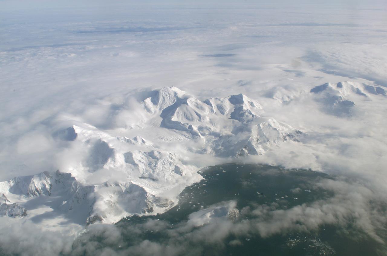
An AirSAR 2004 view from the DC-8 as it approaches the Larsen Ice Shelf, which is part of the Antarctic Peninsula. AirSAR 2004 is a three-week expedition in Central and South America by an international team of scientists that is using an all-weather imaging tool, called the Airborne Synthetic Aperture Radar (AirSAR), located onboard NASA's DC-8 airborne laboratory. Scientists from many parts of the world are combining ground research with NASA's AirSAR technology to improve and expand on the quality of research they are able to conduct. These photos are from the DC-8 aircraft while flying an AirSAR mission over Antarctica. The Antarctic Peninsula is more similar to Alaska and Patagonia than to the rest of the Antarctic continent. It is drained by fast glaciers, receives abundant precipitation, and melts significantly in the summer months. In recent decades, the Peninsula has experienced significant atmospheric warming (about 2 degrees C since 1950), which has triggered a vast and spectacular retreat of its floating ice shelves, glacier reduction, a decrease in permanent snow cover and a lengthening of the melt season. As a result, the contribution to sea level from this region could be rapid and substantial. With an area of 120,000 km, or ten times the Patagonia ice fields, the Peninsula could contribute as much as 0.4mm/yr sea level rise, which would be the largest single contribution to sea level from anywhere in the world. This region is being studied by NASA using a DC-8 equipped with the Airborne Synthetic Aperture Radar developed by scientists from NASA’s Jet Propulsion Laboratory. AirSAR will provide a baseline model and unprecedented mapping of the region. This data will make it possible to determine whether the warming trend is slowing, continuing or accelerating. AirSAR will also provide reliable information on ice shelf thickness to measure the contribution of the glaciers to sea level.

The Larsen Ice Shelf in Antarctica viewed from NASA's DC-8 aircraft during the AirSAR 2004 campaign. AirSAR 2004 is a three-week expedition in Central and South America by an international team of scientists that is using an all-weather imaging tool, called the Airborne Synthetic Aperture Radar (AirSAR), located onboard NASA's DC-8 airborne laboratory. Scientists from many parts of the world are combining ground research with NASA's AirSAR technology to improve and expand on the quality of research they are able to conduct. These photos are from the DC-8 aircraft while flying an AirSAR mission over Antarctica. The Antarctic Peninsula is more similar to Alaska and Patagonia than to the rest of the Antarctic continent. It is drained by fast glaciers, receives abundant precipitation, and melts significantly in the summer months. In recent decades, the Peninsula has experienced significant atmospheric warming (about 2 degrees C since 1950), which has triggered a vast and spectacular retreat of its floating ice shelves, glacier reduction, a decrease in permanent snow cover and a lengthening of the melt season. As a result, the contribution to sea level from this region could be rapid and substantial. With an area of 120,000 km, or ten times the Patagonia ice fields, the Peninsula could contribute as much as 0.4mm/yr sea level rise, which would be the largest single contribution to sea level from anywhere in the world. This region is being studied by NASA using a DC-8 equipped with an Airborne Synthetic Aperture Radar (AirSAR) developed by scientists from NASA’s Jet Propulsion Laboratory. AirSAR will provide a baseline model and unprecedented mapping of the region. This data will make it possible to determine whether the warming trend is slowing, continuing or accelerating. AirSAR will also provide reliable information on ice shelf thickness to measure the contribution of the glaciers to sea level.
The Larsen Ice Shelf in Antarctica viewed from NASA's DC-8 aircraft during the AirSAR 2004 campaign. AirSAR 2004 is a three-week expedition in Central and South America by an international team of scientists that is using an all-weather imaging tool, called the Airborne Synthetic Aperture Radar (AirSAR), located onboard NASA's DC-8 airborne laboratory. Scientists from many parts of the world are combining ground research with NASA's AirSAR technology to improve and expand on the quality of research they are able to conduct. These photos are from the DC-8 aircraft while flying an AirSAR mission over Antarctica. The Antarctic Peninsula is more similar to Alaska and Patagonia than to the rest of the Antarctic continent. It is drained by fast glaciers, receives abundant precipitation, and melts significantly in the summer months. In recent decades, the Peninsula has experienced significant atmospheric warming (about 2 degrees C since 1950), which has triggered a vast and spectacular retreat of its floating ice shelves, glacier reduction, a decrease in permanent snow cover and a lengthening of the melt season. As a result, the contribution to sea level from this region could be rapid and substantial. With an area of 120,000 km, or ten times the Patagonia ice fields, the Peninsula could contribute as much as 0.4mm/yr sea level rise, which would be the largest single contribution to sea level from anywhere in the world. This region is being studied by NASA using a DC-8 equipped with the Airborne Synthetic Aperture Radar developed by scientists from NASA’s Jet Propulsion Laboratory. AirSAR will provide a baseline model and unprecedented mapping of the region. This data will make it possible to determine whether the warming trend is slowing, continuing or accelerating. AirSAR will also provide reliable information on ice shelf thickness to measure the contribution of the glaciers to sea level.

The Larsen Ice Shelf in Antarctica viewed from NASA's DC-8 aircraft during the AirSAR 2004 campaign. AirSAR 2004 is a three-week expedition in Central and South America by an international team of scientists that is using an all-weather imaging tool, called the Airborne Synthetic Aperture Radar (AirSAR), located onboard NASA's DC-8 airborne laboratory. Scientists from many parts of the world are combining ground research with NASA's AirSAR technology to improve and expand on the quality of research they are able to conduct. These photos are from the DC-8 aircraft while flying an AirSAR mission over Antarctica. The Antarctic Peninsula is more similar to Alaska and Patagonia than to the rest of the Antarctic continent. It is drained by fast glaciers, receives abundant precipitation, and melts significantly in the summer months. In recent decades, the Peninsula has experienced significant atmospheric warming (about 2 degrees C since 1950), which has triggered a vast and spectacular retreat of its floating ice shelves, glacier reduction, a decrease in permanent snow cover and a lengthening of the melt season. As a result, the contribution to sea level from this region could be rapid and substantial. With an area of 120,000 km, or ten times the Patagonia ice fields, the Peninsula could contribute as much as 0.4mm/yr sea level rise, which would be the largest single contribution to sea level from anywhere in the world. This region is being studied by NASA using a DC-8 equipped with the Airborne Synthetic Aperture Radar developed by scientists from NASA’s Jet Propulsion Laboratory. AirSAR will provide a baseline model and unprecedented mapping of the region. This data will make it possible to determine whether the warming trend is slowing, continuing or accelerating. AirSAR will also provide reliable information on ice shelf thickness to measure the contribution of the glaciers to sea level.
The Larsen Ice Shelf in Antarctica viewed from NASA's DC-8 aircraft during the AirSAR 2004 campaign. AirSAR 2004 is a three-week expedition in Central and South America by an international team of scientists that is using an all-weather imaging tool, called the Airborne Synthetic Aperture Radar (AirSAR), located onboard NASA's DC-8 airborne laboratory. Scientists from many parts of the world are combining ground research with NASA's AirSAR technology to improve and expand on the quality of research they are able to conduct. These photos are from the DC-8 aircraft while flying an AirSAR mission over Antarctica. The Antarctic Peninsula is more similar to Alaska and Patagonia than to the rest of the Antarctic continent. It is drained by fast glaciers, receives abundant precipitation, and melts significantly in the summer months. In recent decades, the Peninsula has experienced significant atmospheric warming (about 2 degrees C since 1950), which has triggered a vast and spectacular retreat of its floating ice shelves, glacier reduction, a decrease in permanent snow cover and a lengthening of the melt season. As a result, the contribution to sea level from this region could be rapid and substantial. With an area of 120,000 km, or ten times the Patagonia ice fields, the Peninsula could contribute as much as 0.4mm/yr sea level rise, which would be the largest single contribution to sea level from anywhere in the world. This region is being studied by NASA using a DC-8 equipped with the Airborne Synthetic Aperture Radar developed by scientists from NASA’s Jet Propulsion Laboratory. AirSAR will provide a baseline model and unprecedented mapping of the region. This data will make it possible to determine whether the warming trend is slowing, continuing or accelerating. AirSAR will also provide reliable information on ice shelf thickness to measure the contribution of the glaciers to sea level.
The Larsen Ice Shelf in Antarctica viewed from NASA's DC-8 aircraft during the AirSAR 2004 campaign. AirSAR 2004 is a three-week expedition in Central and South America by an international team of scientists that is using an all-weather imaging tool, called the Airborne Synthetic Aperture Radar (AirSAR), located onboard NASA's DC-8 airborne laboratory. Scientists from many parts of the world are combining ground research with NASA's AirSAR technology to improve and expand on the quality of research they are able to conduct. These photos are from the DC-8 aircraft while flying an AirSAR mission over Antarctica. The Antarctic Peninsula is more similar to Alaska and Patagonia than to the rest of the Antarctic continent. It is drained by fast glaciers, receives abundant precipitation, and melts significantly in the summer months. In recent decades, the Peninsula has experienced significant atmospheric warming (about 2 degrees C since 1950), which has triggered a vast and spectacular retreat of its floating ice shelves, glacier reduction, a decrease in permanent snow cover and a lengthening of the melt season. As a result, the contribution to sea level from this region could be rapid and substantial. With an area of 120,000 km, or ten times the Patagonia ice fields, the Peninsula could contribute as much as 0.4mm/yr sea level rise, which would be the largest single contribution to sea level from anywhere in the world. This region is being studied by NASA using a DC-8 equipped with the Airborne Synthetic Aperture Radar developed by scientists from NASA’s Jet Propulsion Laboratory. AirSAR will provide a baseline model and unprecedented mapping of the region. This data will make it possible to determine whether the warming trend is slowing, continuing or accelerating. AirSAR will also provide reliable information on ice shelf thickness to measure the contribution of the glaciers to sea level.
The Larsen Ice Shelf in Antarctica viewed from NASA's DC-8 aircraft during the AirSAR 2004 campaign. AirSAR 2004 is a three-week expedition in Central and South America by an international team of scientists that is using an all-weather imaging tool, called the Airborne Synthetic Aperture Radar (AirSAR), located onboard NASA's DC-8 airborne laboratory. Scientists from many parts of the world are combining ground research with NASA's AirSAR technology to improve and expand on the quality of research they are able to conduct. These photos are from the DC-8 aircraft while flying an AirSAR mission over Antarctica. The Antarctic Peninsula is more similar to Alaska and Patagonia than to the rest of the Antarctic continent. It is drained by fast glaciers, receives abundant precipitation, and melts significantly in the summer months. In recent decades, the Peninsula has experienced significant atmospheric warming (about 2 degrees C since 1950), which has triggered a vast and spectacular retreat of its floating ice shelves, glacier reduction, a decrease in permanent snow cover and a lengthening of the melt season. As a result, the contribution to sea level from this region could be rapid and substantial. With an area of 120,000 km, or ten times the Patagonia ice fields, the Peninsula could contribute as much as 0.4mm/yr sea level rise, which would be the largest single contribution to sea level from anywhere in the world. This region is being studied by NASA using a DC-8 equipped with the Airborne Synthetic Aperture Radar developed by scientists from NASA’s Jet Propulsion Laboratory. AirSAR will provide a baseline model and unprecedented mapping of the region. This data will make it possible to determine whether the warming trend is slowing, continuing or accelerating. AirSAR will also provide reliable information on ice shelf thickness to measure the contribution of the glaciers to sea level.
NASA JPL scientists Yunling Lou and Dr. Eric Rignot work on line selection while flying AirSAR missions over the Antarctic Peninsula. AirSAR 2004 is a three-week expedition in Central and South America by an international team of scientists that is using an all-weather imaging tool, called the Airborne Synthetic Aperture Radar (AirSAR), located onboard NASA's DC-8 airborne laboratory. Scientists from many parts of the world are combining ground research with NASA's AirSAR technology to improve and expand on the quality of research they are able to conduct. These photos are from the DC-8 aircraft while flying an AirSAR mission over Antarctica. The Antarctic Peninsula is more similar to Alaska and Patagonia than to the rest of the Antarctic continent. It is drained by fast glaciers, receives abundant precipitation, and melts significantly in the summer months. In recent decades, the Peninsula has experienced significant atmospheric warming (about 2 degrees C since 1950), which has triggered a vast and spectacular retreat of its floating ice shelves, glacier reduction, a decrease in permanent snow cover and a lengthening of the melt season. As a result, the contribution to sea level from this region could be rapid and substantial. With an area of 120,000 km, or ten times the Patagonia ice fields, the Peninsula could contribute as much as 0.4mm/yr sea level rise, which would be the largest single contribution to sea level from anywhere in the world. This region is being studied by NASA using a DC-8 equipped with the Airborne Synthetic Aperture Radar developed by scientists from NASA’s Jet Propulsion Laboratory. AirSAR will provide a baseline model and unprecedented mapping of the region. This data will make it possible to determine whether the warming trend is slowing, continuing or accelerating. AirSAR will also provide reliable information on ice shelf thickness to measure the contribution of the glaciers to sea level.
The Larsen Ice Shelf in Antarctica viewed from NASA's DC-8 aircraft during the AirSAR 2004 campaign. AirSAR 2004 is a three-week expedition in Central and South America by an international team of scientists that is using an all-weather imaging tool, called the Airborne Synthetic Aperture Radar (AirSAR), located onboard NASA's DC-8 airborne laboratory. Scientists from many parts of the world are combining ground research with NASA's AirSAR technology to improve and expand on the quality of research they are able to conduct. These photos are from the DC-8 aircraft while flying an AirSAR mission over Antarctica. The Antarctic Peninsula is more similar to Alaska and Patagonia than to the rest of the Antarctic continent. It is drained by fast glaciers, receives abundant precipitation, and melts significantly in the summer months. In recent decades, the Peninsula has experienced significant atmospheric warming (about 2 degrees C since 1950), which has triggered a vast and spectacular retreat of its floating ice shelves, glacier reduction, a decrease in permanent snow cover and a lengthening of the melt season. As a result, the contribution to sea level from this region could be rapid and substantial. With an area of 120,000 km, or ten times the Patagonia ice fields, the Peninsula could contribute as much as 0.4mm/yr sea level rise, which would be the largest single contribution to sea level from anywhere in the world. This region is being studied by NASA using a DC-8 equipped with the Airborne Synthetic Aperture Radar developed by scientists from NASA’s Jet Propulsion Laboratory. AirSAR will provide a baseline model and unprecedented mapping of the region. This data will make it possible to determine whether the warming trend is slowing, continuing or accelerating. AirSAR will also provide reliable information on ice shelf thickness to measure the contribution of the glaciers to sea level.
ISS010-E-18306 (19 February 2005) --- Patagonia Glacier in Argentina is featured in this image photographed by an Expedition 10 crewmember on the International Space Station.
ISS047e014747 (03/22/2016) --- Crewmembers of the International Space Stations Expedition 47 captured this image of southern South America. Patagonia is a sparsely populated region located at the southern end of South America, shared by Argentina and Chile. The region comprises the southern section of the Andes mountains as well as the deserts, steppes and grasslands east of this southern portion of the Andes. The Colorado and Barrancas rivers, which run from the Andes to the Atlantic, are commonly considered the northern limit of Argentine Patagonia
ISS033-E-010399 (7 Oct. 2012) --- One of the Expedition 33 crew members aboard the International Space Station took this photograph of Chile featuring the North Patagonia Ice Field and the Arenales Glaciers.
iss068e039568 (Jan. 10, 2023) --- Argentino Lake in the Patagonia region of southern Argentina is pictured from the International Space Station as it orbited 268 miles above the Pacific Ocean off the coast of the South American nation.

iss071e064589 (May 8, 2024) --- An artifical lake created by the Florentino Ameghino Dam on the Chubut River is pictured from the International Space Station as it orbited 266 miles above the Patagonia region of Argentina.
This anaglyph, from NASA Shuttle Radar Topography Mission, shows basalt cliffs along the northwest edge of the Meseta de Somuncura plateau near Sierra Colorada, Argentina. 3D glasses are necessary to view this image.

ISS043E044527 (03/23/2015) --- This Earth observation of the Patagonia Ice Fields in South America was taken during a day pass of the International Space Station by the crew of Expedition 43. The Commander of 43, NASA astronaut Terry Virts tweeted this comment on the Earth image: "Awe-inspiring Earth"!

iss072e030246 (Oct. 7, 2024) --- The first rays of an orbital sunrise illuminate Earth's atmosphere in this photograph from the International Space Station as it orbited 269 miles above the Pacific Ocean near Chile's Patagonia coast on the South American continent.
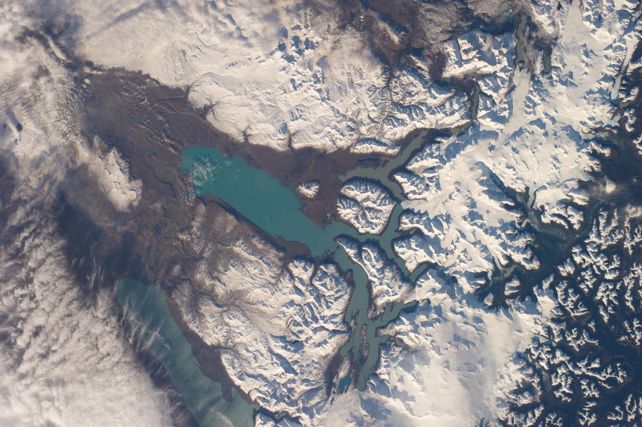
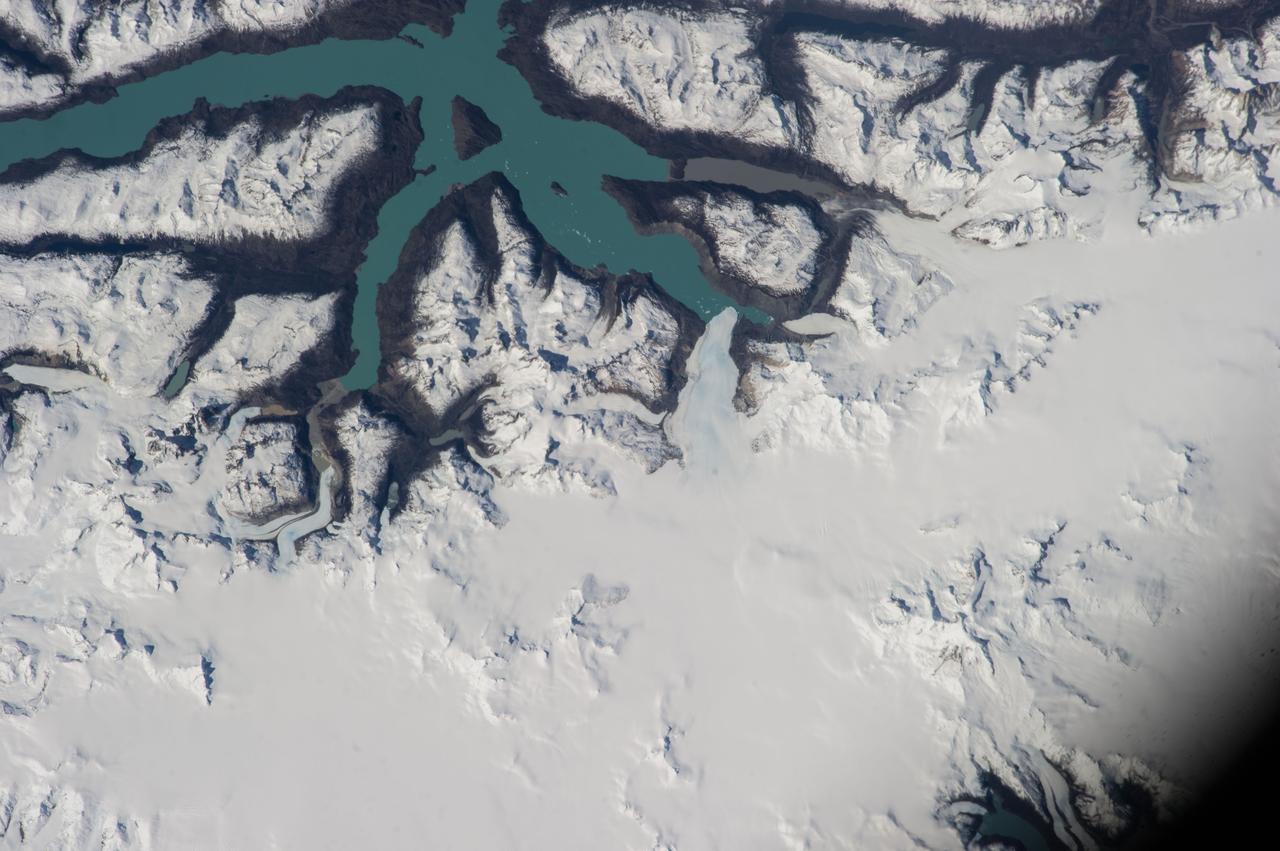
ISS040-E-006206 (1 June 2014) --- One of the Expedition 40 crew members aboard the International Space Station on June 1, 2014, photographed a series of images of the glacial lakes of Patagonia, a region located at the southern end of South America, shared by Argentina and Chile.
ISS037-E-004176 (28 Sept. 2013) --- Part of Chile, featuring Lake O'Higgins, Andes Mountains and a South Patagonia ice field, was photographed by one of the Expedition 37 crew members aboard the International Space Station on Sept. 28, 2013.
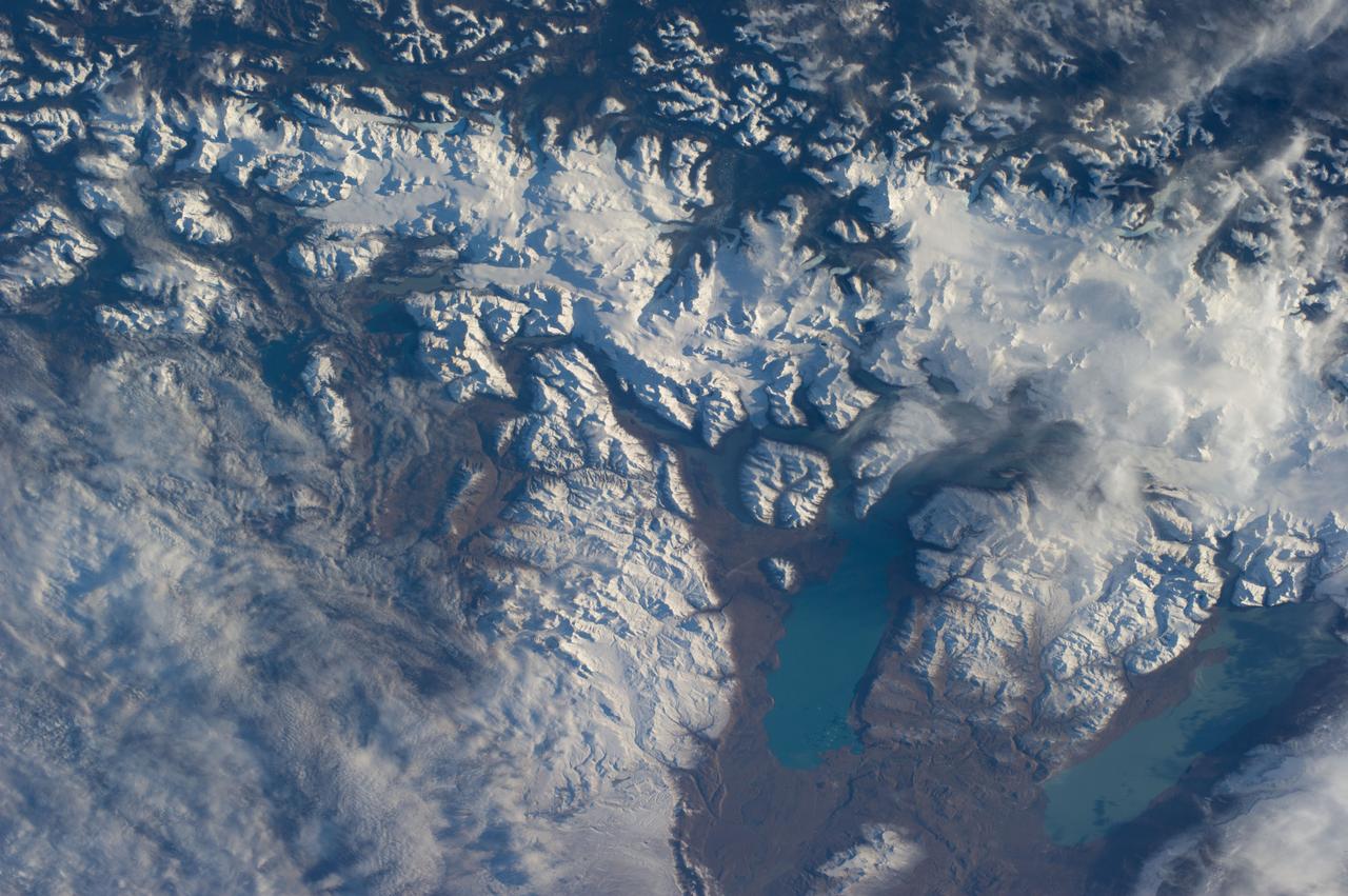
ISS040-E-006219 (1 June 2014) --- One of the Expedition 40 crew members aboard the International Space Station on June 1, 2014, photographed a series of images of the glacial lakes of Patagonia, a region located at the southern end of South America, shared by Argentina and Chile.

iss072e024551 (Sept. 25, 2024) --- Comet C/2023 A3 (Tsuchinshan-ATLAS) was about 44 million miles away from Earth in this photograph from the International Space Station as it orbited 272 miles above the South Pacific Ocean west of the Patagonia region of South America just before sunrise.
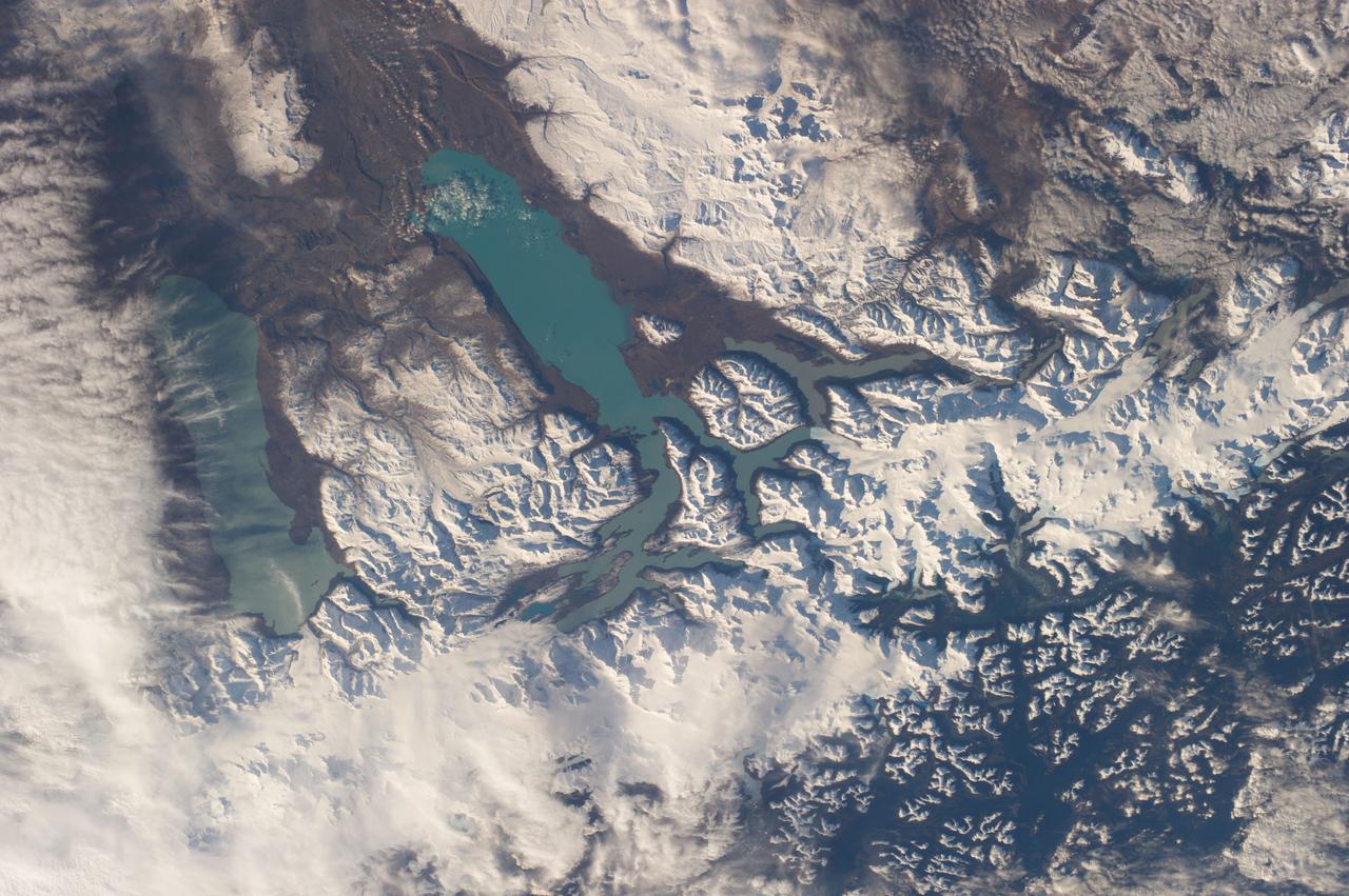
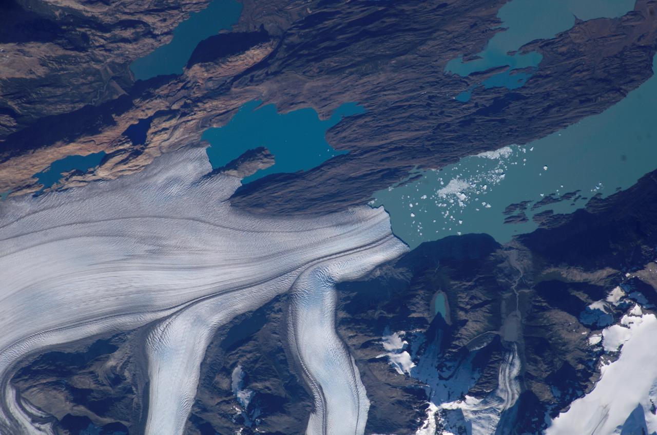
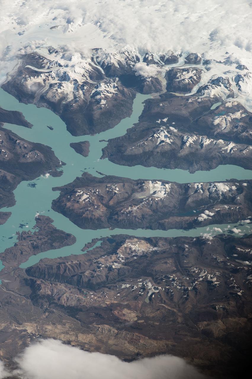
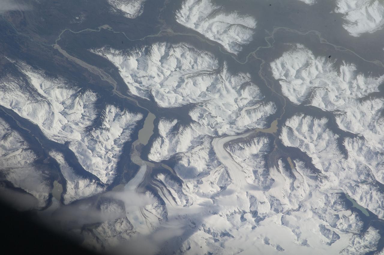
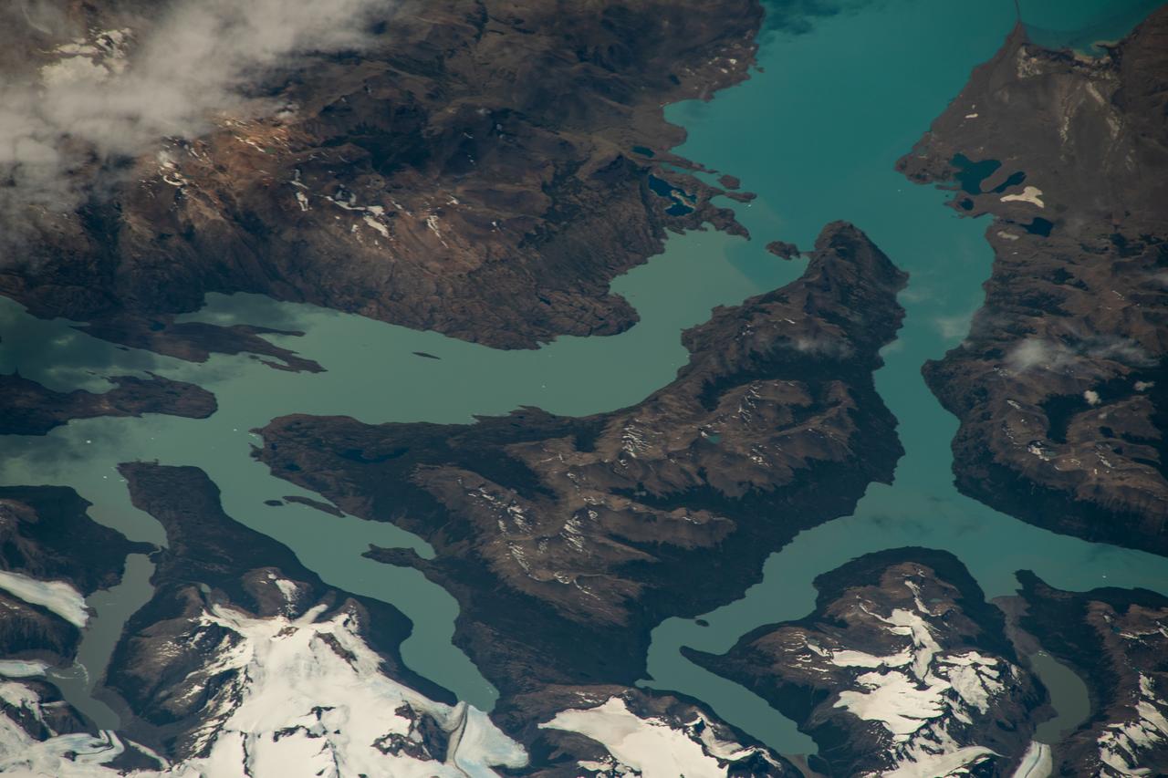
ISS040-E-006209 (1 June 2014) --- One of the Expedition 40 crew members aboard the International Space Station on June 1, 2014, photographed a series of images of the glacial lakes of Patagonia, a region located at the southern end of South America, shared by Argentina and Chile.
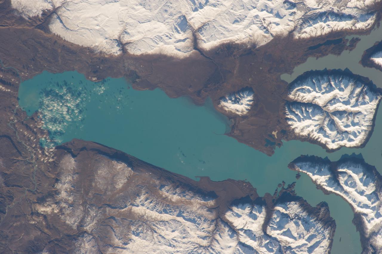
ISS040-E-006208 (1 June 2014) --- One of the Expedition 40 crew members aboard the International Space Station on June 1, 2014, photographed a series of images of the glacial lakes of Patagonia, a region located at the southern end of South America, shared by Argentina and Chile.

iss072e316172 (Oct. 23, 2024) --- The International Space Station is pictured from the SpaceX Dragon crew spacecraft by a SpaceX Crew-8 member shortly after undocking from the Harmony module's space-facing port. The orbital outpost was soaring 272 miles above the cloudy Patagonia region of South America at the time of this photograph.
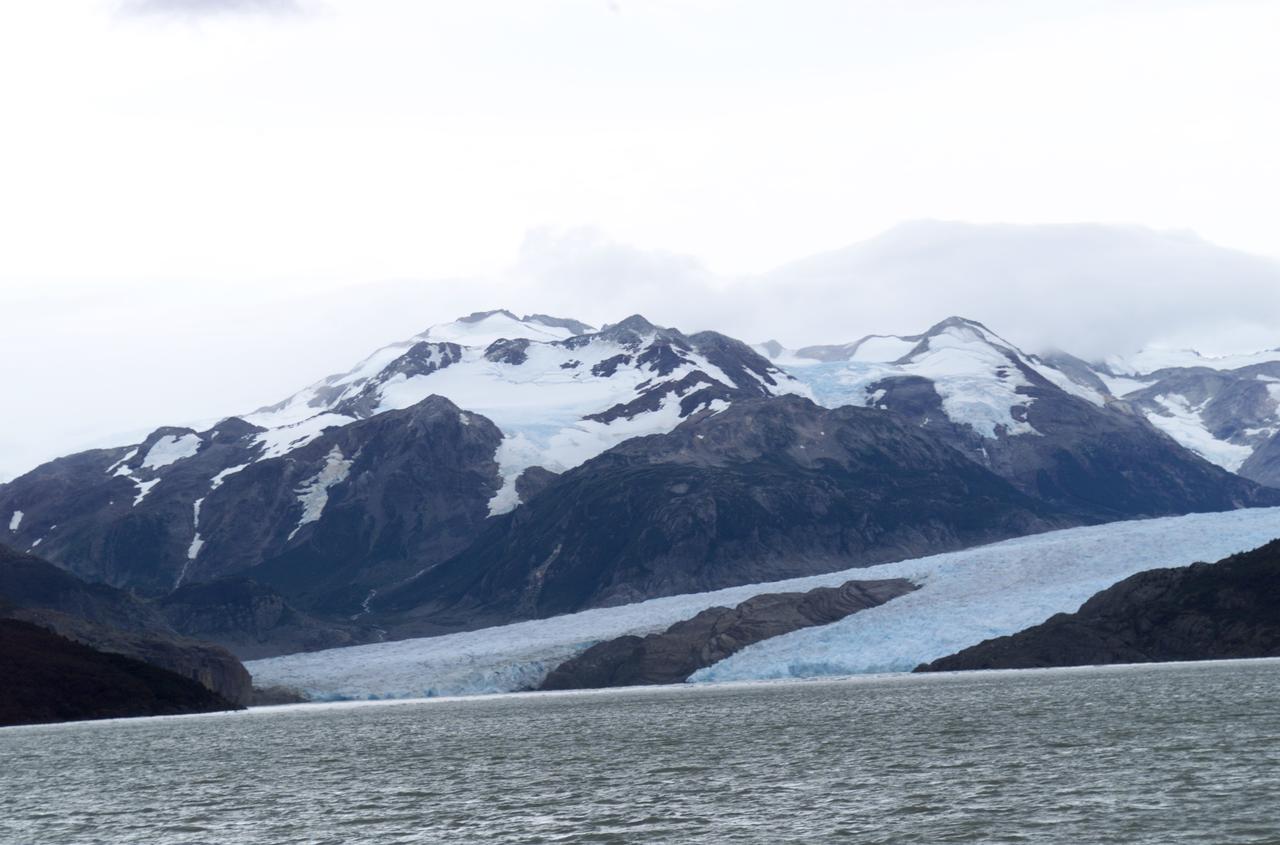
Glacier Grey view from Lago Grey (Grey Lake), photographed during NASA's AirSAR 2004 campaign in Chile. Land visible in this photo was covered by glacier just 6 years earlier. AirSAR 2004 is a three-week expedition in Central and South America by an international team of scientists that is using an all-weather imaging tool, called the Airborne Synthetic Aperture Radar (AirSAR), located onboard NASA's DC-8 airborne laboratory. Scientists from many parts of the world are combining ground research with NASA's AirSAR technology to improve and expand on the quality of research they are able to conduct. Founded in 1959, Torres del Paine National Park encompasses 450,000 acres in the Patagonia region of Chile. This region is being studied by NASA using a DC-8 equipped with an Airborne Synthetic Aperture Radar (AirSAR) developed by scientists from NASA’s Jet Propulsion Laboratory. This is a very sensitive region that is important to scientists because the temperature has been consistently rising causing a subsequent melting of the region’s glaciers. AirSAR will provide a baseline model and unprecedented mapping of the region. This data will make it possible to determine whether the warming trend is slowing, continuing or accelerating. AirSAR will also provide reliable information on ice shelf thickness to measure the contribution of the glaciers to sea level.

JPL scientist Dr. David Imel and U.S. Air Force Colonel Gwen Linde, the Defense Department Attache Officer assigned to the Chilean Embassy, lead Chilean students on a tour of the DC-8 aircraft at Carlos Ibanez del Campo International Airport in Punta Arenas, Chile. AirSAR 2004 is a three-week expedition by an international team of scientists that is using an all-weather imaging tool, called the Airborne Synthetic Aperture Radar (AirSAR) which is located onboard NASA's DC-8 airborne laboratory. Scientists from many parts of the world including NASA's Jet Propulsion Laboratory are combining ground research done in several areas in Central and South America with NASA's AirSAR technology to improve and expand on the quality of research they are able to conduct. In South America and Antarctica, AirSAR will collect imagery and data to help determine the contribution of Southern Hemisphere glaciers to sea level rise due to climate change. In Patagonia, researchers found this contribution had more than doubled from 1995 to 2000, compared to the previous 25 years. AirSAR data will make it possible to determine whether that trend is decreasing, continuing or accelerating. AirSAR will also provide reliable information on ice shelf thickness to measure the contribution of the glaciers to sea level.

NASA DC-8 Pilots Craig Bomben and Bill Brockett explain the DC-8 cockpit to Chilean students onboard the DC-8 aircraft at Carlos Ibanez del Campo International Airport in Punta Arenas, Chile. AirSAR 2004 is a three-week expedition by an international team of scientists that is using an all-weather imaging tool, called the Airborne Synthetic Aperture Radar (AirSAR) which is located onboard NASA's DC-8 airborne laboratory. Scientists from many parts of the world including NASA's Jet Propulsion Laboratory are combining ground research done in several areas in Central and South America with NASA's AirSAR technology to improve and expand on the quality of research they are able to conduct. In South America and Antarctica, AirSAR will collect imagery and data to help determine the contribution of Southern Hemisphere glaciers to sea level rise due to climate change. In Patagonia, researchers found this contribution had more than doubled from 1995 to 2000, compared to the previous 25 years. AirSAR data will make it possible to determine whether that trend is decreasing, continuing or accelerating. AirSAR will also provide reliable information on ice shelf thickness to measure the contribution of the glaciers to sea level.

NASA DC-8 Ground Support Technicians Mark Corlew and Mike Lakowski perform routine maintenance on the aircraft at Carlos Ibanez del Campo International Airport in Punta Arenas, Chile. AirSAR 2004 is a three-week expedition by an international team of scientists that is using an all-weather imaging tool, called the Airborne Synthetic Aperture Radar (AirSAR) which is located onboard NASA's DC-8 airborne laboratory. Scientists from many parts of the world including NASA's Jet Propulsion Laboratory are combining ground research done in several areas in Central and South America with NASA's AirSAR technology to improve and expand on the quality of research they are able to conduct. In South America and Antarctica, AirSAR will collect imagery and data to help determine the contribution of Southern Hemisphere glaciers to sea level rise due to climate change. In Patagonia, researchers found this contribution had more than doubled from 1995 to 2000, compared to the previous 25 years. AirSAR data will make it possible to determine whether that trend is decreasing, continuing or accelerating. AirSAR will also provide reliable information on ice shelf thickness to measure the contribution of the glaciers to sea level.

NASA DC-8 Ground Support Technician Joe Niquette performs routine maintenance on the DC-8 aircraft at Carlos Ibanez del Campo International Airport in Punta Arenas, Chile. AirSAR 2004 is a three-week expedition by an international team of scientists that is using an all-weather imaging tool, called the Airborne Synthetic Aperture Radar (AirSAR) which is located onboard NASA's DC-8 airborne laboratory. Scientists from many parts of the world including NASA's Jet Propulsion Laboratory are combining ground research done in several areas in Central and South America with NASA's AirSAR technology to improve and expand on the quality of research they are able to conduct. In South America and Antarctica, AirSAR will collect imagery and data to help determine the contribution of Southern Hemisphere glaciers to sea level rise due to climate change. In Patagonia, researchers found this contribution had more than doubled from 1995 to 2000, compared to the previous 25 years. AirSAR data will make it possible to determine whether that trend is decreasing, continuing or accelerating. AirSAR will also provide reliable information on ice shelf thickness to measure the contribution of the glaciers to sea level.
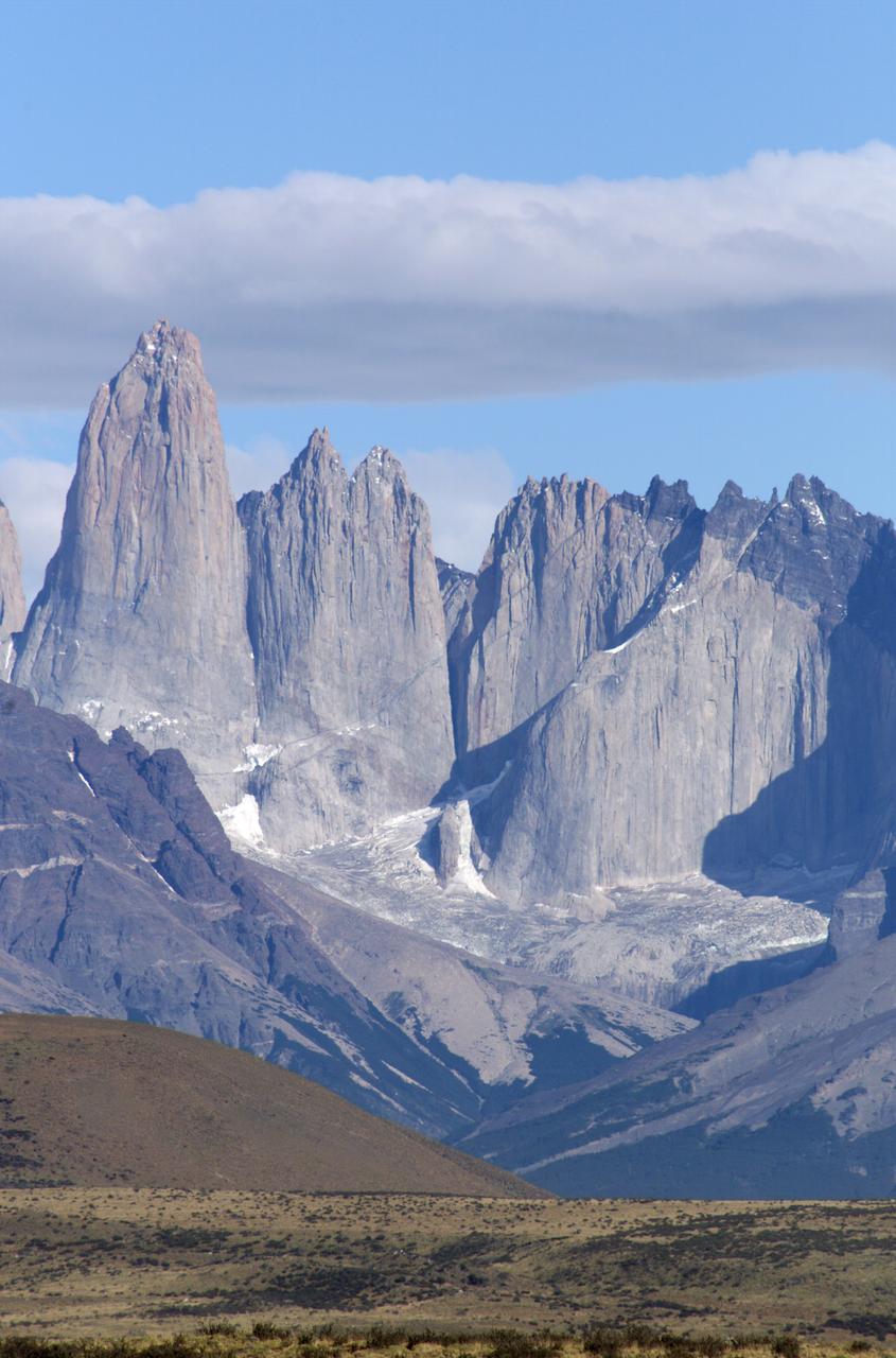
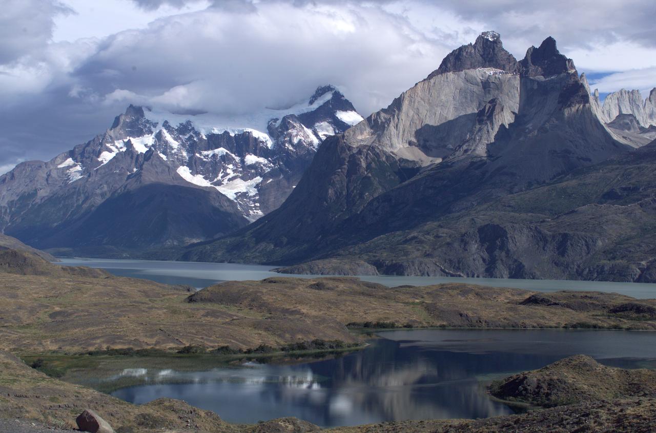
The Cuernos del Paine mountains in Torres del Paine National Park in Chile, photographed during NASA's AirSAR 2004 campaign. AirSAR 2004 is a three-week expedition in Central and South America by an international team of scientists that is using an all-weather imaging tool, called the Airborne Synthetic Aperture Radar (AirSAR), located onboard NASA's DC-8 airborne laboratory. Scientists from many parts of the world are combining ground research with NASA's AirSAR technology to improve and expand on the quality of research they are able to conduct. Founded in 1959, Torres del Paine National Park encompasses 450,000 acres in the Patagonia region of Chile. This region is being studied by NASA using a DC-8 equipped with an Airborne Synthetic Aperture Radar (AirSAR) developed by scientists from NASA’s Jet Propulsion Laboratory. This is a very sensitive region that is important to scientists because the temperature has been consistently rising causing a subsequent melting of the region’s glaciers. AirSAR will provide a baseline model and unprecedented mapping of the region. This data will make it possible to determine whether the warming trend is slowing, continuing or accelerating. AirSAR will also provide reliable information on ice shelf thickness to measure the contribution of the glaciers to sea level.
Close-up view of Grey Glacier from Lago Grey (Grey Lake), taken during NASA's AirSAR 2004 campaign in Chile. AirSAR 2004 is a three-week expedition in Central and South America by an international team of scientists that is using an all-weather imaging tool, called the Airborne Synthetic Aperture Radar (AirSAR), located onboard NASA's DC-8 airborne laboratory. Scientists from many parts of the world are combining ground research with NASA's AirSAR technology to improve and expand on the quality of research they are able to conduct. Founded in 1959, Torres del Paine National Park encompasses 450,000 acres in the Patagonia region of Chile. This region is being studied by NASA using a DC-8 equipped with an Airborne Synthetic Aperture Radar (AirSAR) developed by scientists from NASA’s Jet Propulsion Laboratory. This is a very sensitive region that is important to scientists because the temperature has been consistently rising causing a subsequent melting of the region’s glaciers. AirSAR will provide a baseline model and unprecedented mapping of the region. This data will make it possible to determine whether the warming trend is slowing, continuing or accelerating. AirSAR will also provide reliable information on ice shelf thickness to measure the contribution of the glaciers to sea level.
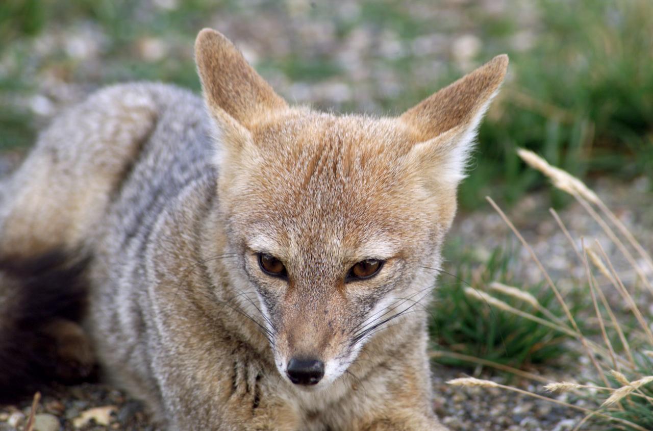
A fox at Torres del Paine National Park in Chile during NASA's AirSAR 2004 campaign. AirSAR 2004 is a three-week expedition in Central and South America by an international team of scientists that is using an all-weather imaging tool, called the Airborne Synthetic Aperture Radar (AirSAR), located onboard NASA's DC-8 airborne laboratory. Scientists from many parts of the world are combining ground research with NASA's AirSAR technology to improve and expand on the quality of research they are able to conduct. Founded in 1959, Torres del Paine National Park encompasses 450,000 acres in the Patagonia region of Chile. This region is being studied by NASA using a DC-8 equipped with an Airborne Synthetic Aperture Radar (AirSAR) developed by scientists from NASA’s Jet Propulsion Laboratory. This is a very sensitive region that is important to scientists because the temperature has been consistently rising causing a subsequent melting of the region’s glaciers. AirSAR will provide a baseline model and unprecedented mapping of the region. This data will make it possible to determine whether the warming trend is slowing, continuing or accelerating. AirSAR will also provide reliable information on ice shelf thickness to measure the contribution of the glaciers to sea level.
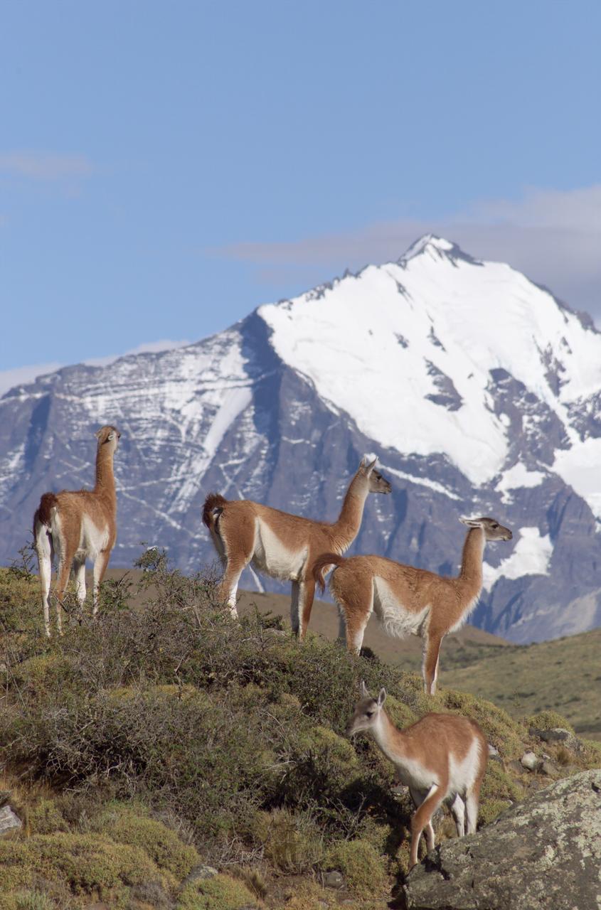
The Cuernos del Paine mountains in Torres del Paine National Park in Chile provide a backdrop to a herd of guanacos during NASA's AirSAR 2004 campaign. AirSAR 2004 is a three-week expedition in Central and South America by an international team of scientists that is using an all-weather imaging tool, called the Airborne Synthetic Aperture Radar (AirSAR), located onboard NASA's DC-8 airborne laboratory. Scientists from many parts of the world are combining ground research with NASA's AirSAR technology to improve and expand on the quality of research they are able to conduct. Founded in 1959, Torres del Paine National Park encompasses 450,000 acres in the Patagonia region of Chile. This region is being studied by NASA using a DC-8 equipped with an Airborne Synthetic Aperture Radar (AirSAR) developed by scientists from NASA’s Jet Propulsion Laboratory. This is a very sensitive region that is important to scientists because the temperature has been consistently rising causing a subsequent melting of the region’s glaciers. AirSAR will provide a baseline model and unprecedented mapping of the region. This data will make it possible to determine whether the warming trend is slowing, continuing or accelerating. AirSAR will also provide reliable information on ice shelf thickness to measure the contribution of the glaciers to sea level.

NASA DC-8 Mission Manager Walter Klein poses with a group of Chilean Students onboard the aircraft at Carlos Ibanez del Campo International Airport in Punta Arenas, Chile. AirSAR 2004 is a three-week expedition by an international team of scientists that is using an all-weather imaging tool, called the Airborne Synthetic Aperture Radar (AirSAR) which is located onboard NASA's DC-8 airborne laboratory. Scientists from many parts of the world including NASA's Jet Propulsion Laboratory are combining ground research done in several areas in Central and South America with NASA's AirSAR technology to improve and expand on the quality of research they are able to conduct. In South America and Antarctica, AirSAR will collect imagery and data to help determine the contribution of Southern Hemisphere glaciers to sea level rise due to climate change. In Patagonia, researchers found this contribution had more than doubled from 1995 to 2000, compared to the previous 25 years. AirSAR data will make it possible to determine whether that trend is decreasing, continuing or accelerating. AirSAR will also provide reliable information on ice shelf thickness to measure the contribution of the glaciers to sea level.
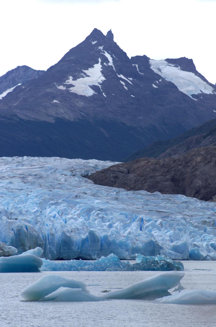
Glacier Grey in front of the Cuernos del Paine mountains, photographed from Lago Grey (Grey Lake) during NASA's AirSAR 2004 campaign in Chile. AirSAR 2004 is a three-week expedition in Central and South America by an international team of scientists that is using an all-weather imaging tool, called the Airborne Synthetic Aperture Radar (AirSAR), located onboard NASA's DC-8 airborne laboratory. Scientists from many parts of the world are combining ground research with NASA's AirSAR technology to improve and expand on the quality of research they are able to conduct. Founded in 1959, Torres del Paine National Park encompasses 450,000 acres in the Patagonia region of Chile. This region is being studied by NASA using a DC-8 equipped with an Airborne Synthetic Aperture Radar (AirSAR) developed by scientists from NASA’s Jet Propulsion Laboratory. This is a very sensitive region that is important to scientists because the temperature has been consistently rising causing a subsequent melting of the region’s glaciers. AirSAR will provide a baseline model and unprecedented mapping of the region. This data will make it possible to determine whether the warming trend is slowing, continuing or accelerating. AirSAR will also provide reliable information on ice shelf thickness to measure the contribution of the glaciers to sea level.
The Cuernos del Paine mountains in Torres del Paine National Park, Chile, during NASA's AirSAR 2004 campaign. AirSAR 2004 is a three-week expedition in Central and South America by an international team of scientists that is using an all-weather imaging tool, called the Airborne Synthetic Aperture Radar (AirSAR), located onboard NASA's DC-8 airborne laboratory. Scientists from many parts of the world are combining ground research with NASA's AirSAR technology to improve and expand on the quality of research they are able to conduct. Founded in 1959, Torres del Paine National Park encompasses 450,000 acres in the Patagonia region of Chile. This region is being studied by NASA using a DC-8 equipped with an Airborne Synthetic Aperture Radar (AirSAR) developed by scientists from NASA’s Jet Propulsion Laboratory. This is a very sensitive region that is important to scientists because the temperature has been consistently rising causing a subsequent melting of the region’s glaciers. AirSAR will provide a baseline model and unprecedented mapping of the region. This data will make it possible to determine whether the warming trend is slowing, continuing or accelerating. AirSAR will also provide reliable information on ice shelf thickness to measure the contribution of the glaciers to sea level.
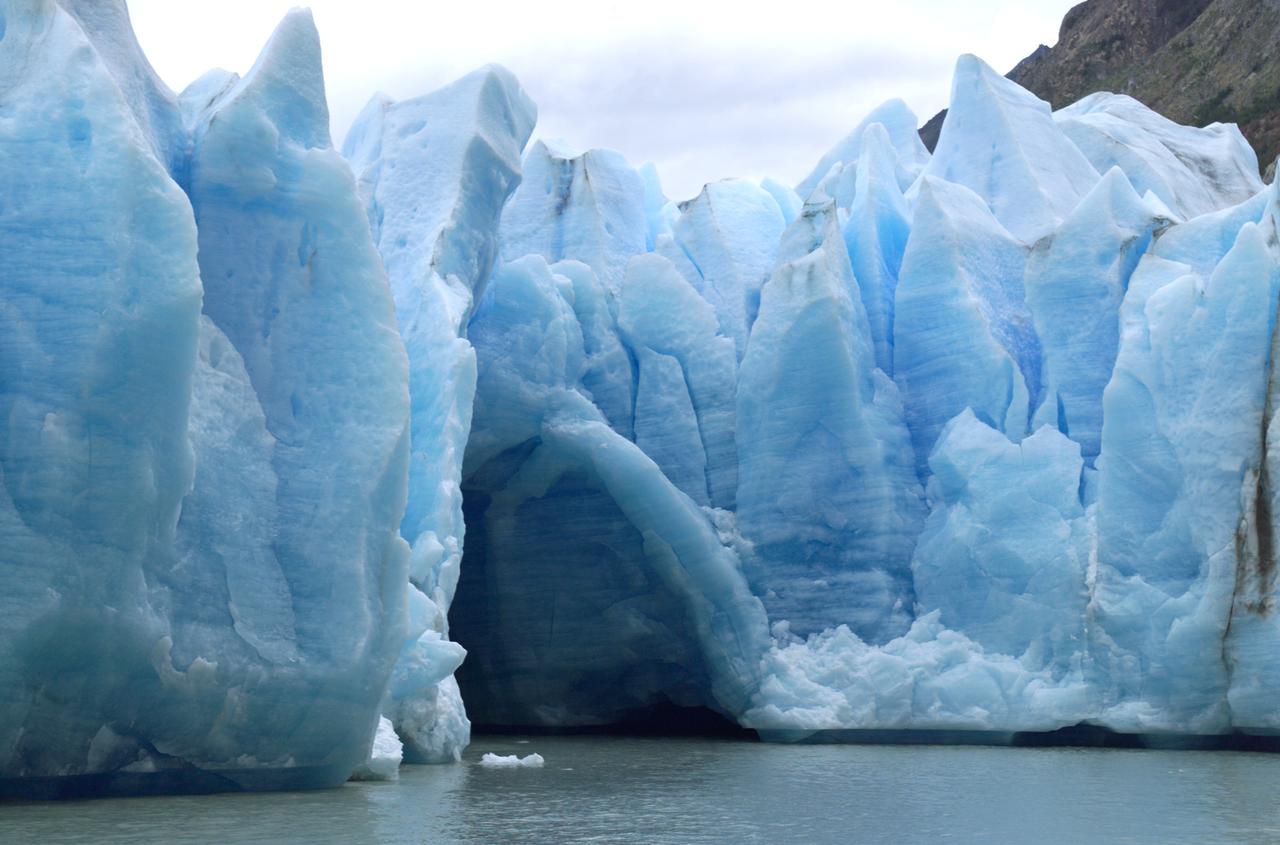
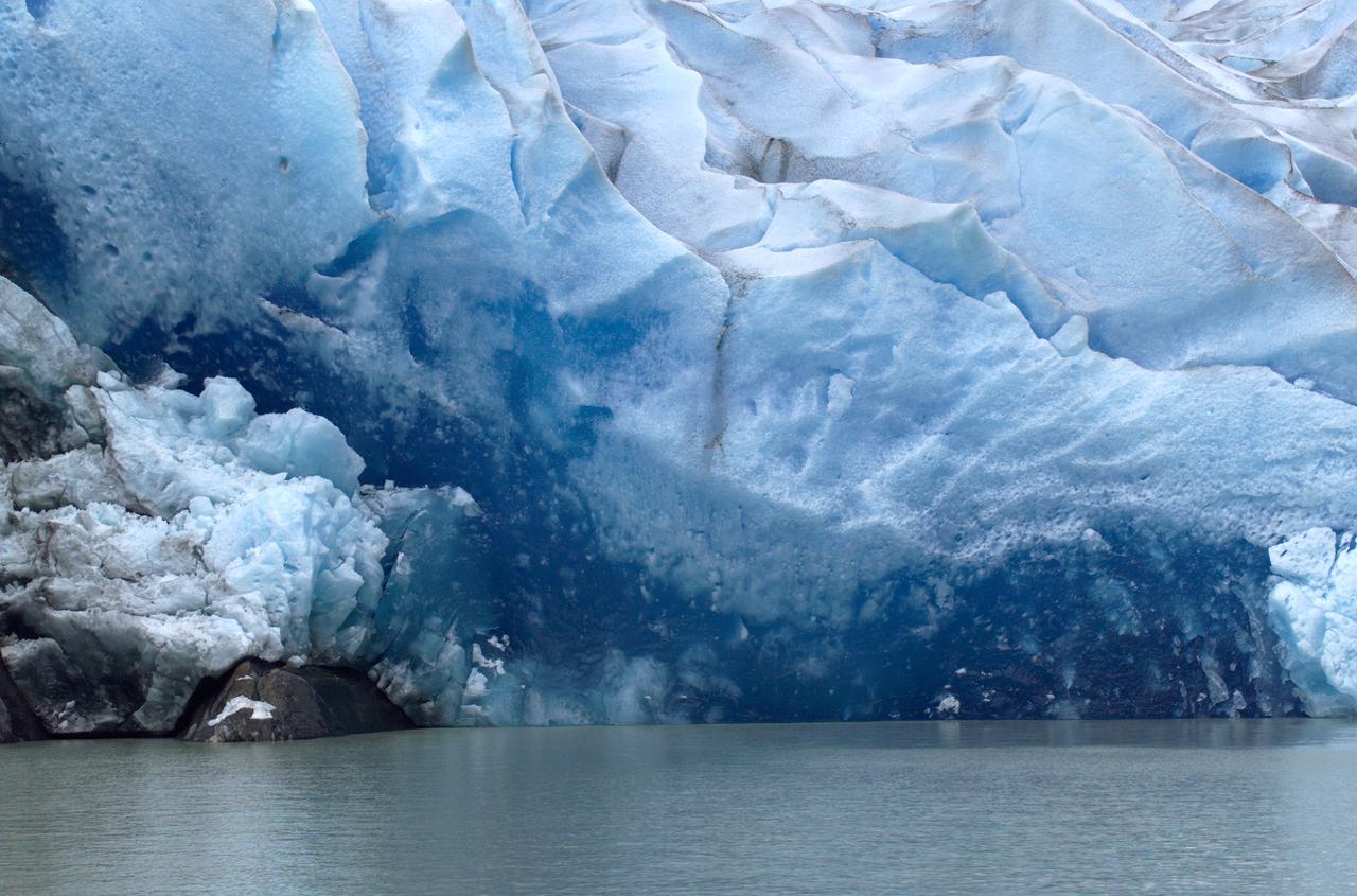
A cave in Glacier Grey in Torres del Paine National Park, seen during NASA's AirSAR 2004 campaign in Chile. AirSAR 2004 is a three-week expedition in Central and South America by an international team of scientists that is using an all-weather imaging tool, called the Airborne Synthetic Aperture Radar (AirSAR), located onboard NASA's DC-8 airborne laboratory. Scientists from many parts of the world are combining ground research with NASA's AirSAR technology to improve and expand on the quality of research they are able to conduct. Founded in 1959, Torres del Paine National Park encompasses 450,000 acres in the Patagonia region of Chile. This region is being studied by NASA using a DC-8 equipped with an Airborne Synthetic Aperture Radar (AirSAR) developed by scientists from NASA’s Jet Propulsion Laboratory. This is a very sensitive region that is important to scientists because the temperature has been consistently rising causing a subsequent melting of the region’s glaciers. AirSAR will provide a baseline model and unprecedented mapping of the region. This data will make it possible to determine whether the warming trend is slowing, continuing or accelerating. AirSAR will also provide reliable information on ice shelf thickness to measure the contribution of the glaciers to sea level.
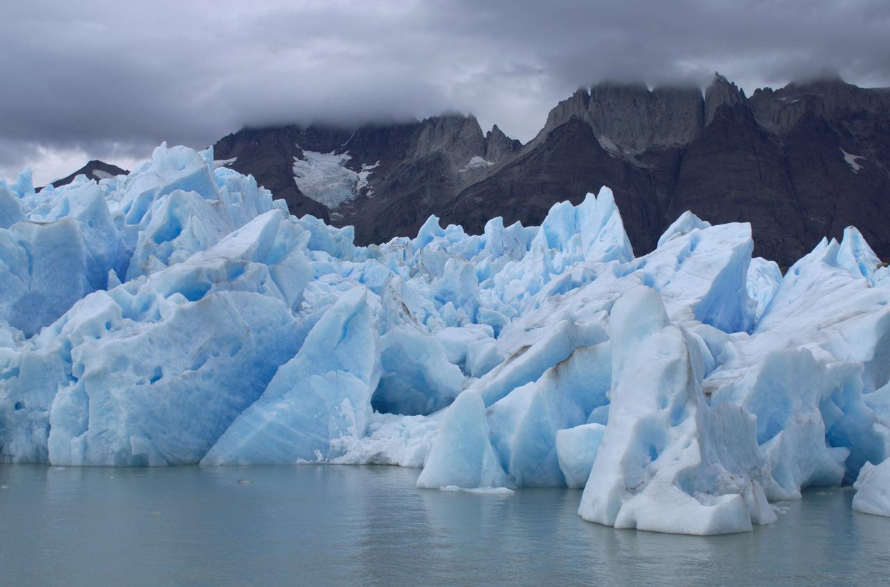
View of Glacier Grey from Lago Grey (Grey Lake), with the Cuernos del Paine mountains in the background, seen during NASA's AirSAR 2004 campaign in Chile. AirSAR 2004 is a three-week expedition in Central and South America by an international team of scientists that is using an all-weather imaging tool, called the Airborne Synthetic Aperture Radar (AirSAR), located onboard NASA's DC-8 airborne laboratory. Scientists from many parts of the world are combining ground research with NASA's AirSAR technology to improve and expand on the quality of research they are able to conduct. Founded in 1959, Torres del Paine National Park encompasses 450,000 acres in the Patagonia region of Chile. This region is being studied by NASA using a DC-8 equipped with an Airborne Synthetic Aperture Radar (AirSAR) developed by scientists from NASA’s Jet Propulsion Laboratory. This is a very sensitive region that is important to scientists because the temperature has been consistently rising causing a subsequent melting of the region’s glaciers. AirSAR will provide a baseline model and unprecedented mapping of the region. This data will make it possible to determine whether the warming trend is slowing, continuing or accelerating. AirSAR will also provide reliable information on ice shelf thickness to measure the contribution of the glaciers to sea level.
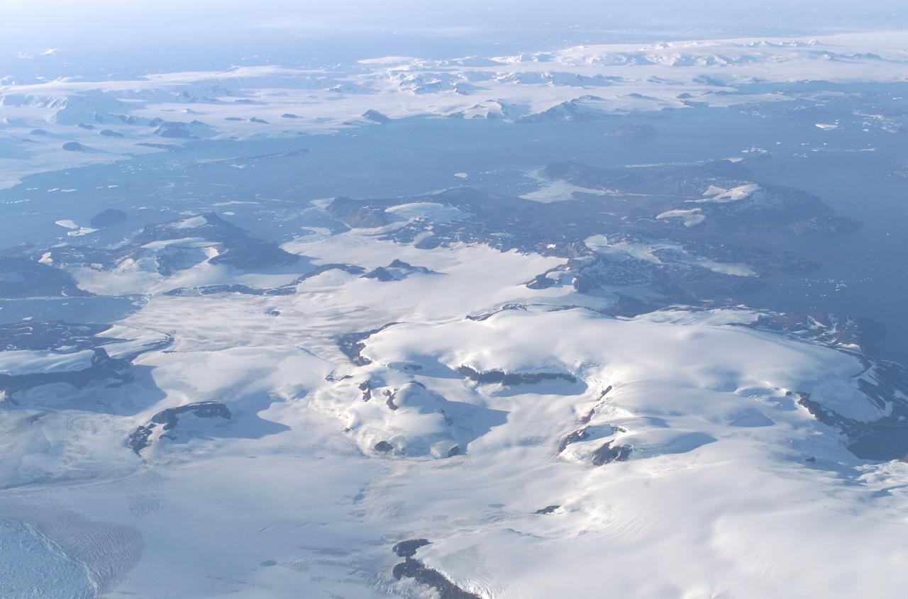
James Ross Island captured by NASA photographer James Ross(no relation), from NASA's DC-8 aircraft during an AirSAR 2004 mission over the Antarctic Peninsula. James Ross Island, named for 19th century British polar explorer Sir James Clark Ross, is located at the northern tip of the Antarctic Peninsula. The island is about 1500 m high and 40-60 km wide. In recent decades, the area has experienced significant atmospheric warming (about 2 degrees C since 1950), which has triggered a vast and spectacular retreat of its floating ice shelves, glacier reduction, a decrease in permanent snow cover and a lengthening of the melt season. AirSAR 2004 is a three-week expedition in Central and South America by an international team of scientists that is using an all-weather imaging tool, called the Airborne Synthetic Aperture Radar (AirSAR), located onboard NASA's DC-8 airborne laboratory. Scientists from many parts of the world are combining ground research with NASA's AirSAR technology to improve and expand on the quality of research they are able to conduct. These photos are from the DC-8 aircraft while flying an AirSAR mission over Antarctica. The Antarctic Peninsula is more similar to Alaska and Patagonia than to the rest of the Antarctic continent. It is drained by fast glaciers, receives abundant precipitation, and melts significantly in the summer months. This region is being studied by NASA using a DC-8 equipped with the Airborne Synthetic Aperture Radar developed by scientists from NASA’s Jet Propulsion Laboratory. AirSAR will provide a baseline model and unprecedented mapping of the region. This data will make it possible to determine whether the warming trend is slowing, continuing or accelerating. AirSAR will also provide reliable information on ice shelf thickness to measure the contribution of the glaciers to sea level.
The Meseta de Somuncura is a broad plateau capped by basalt. Near its western edge is evidence of multiple volcanic events and a complex erosion history.

This anaglyph, from NASA Shuttle Radar Topography Mission, shows Meseta de Somuncura, a broad plateau capped by basalt. Near its western edge is evidence of multiple volcanic events. 3D glasses are necessary to view this image.
Basalt cliffs along the northwest edge of the Meseta de Somuncura plateau near Sierra Colorada, Argentina show an unusual and striking pattern of erosion.
In addition to an elevation model of most of Earth landmass, NASA Shuttle Radar Topography Mission will produce C-band radar imagery of the same area.
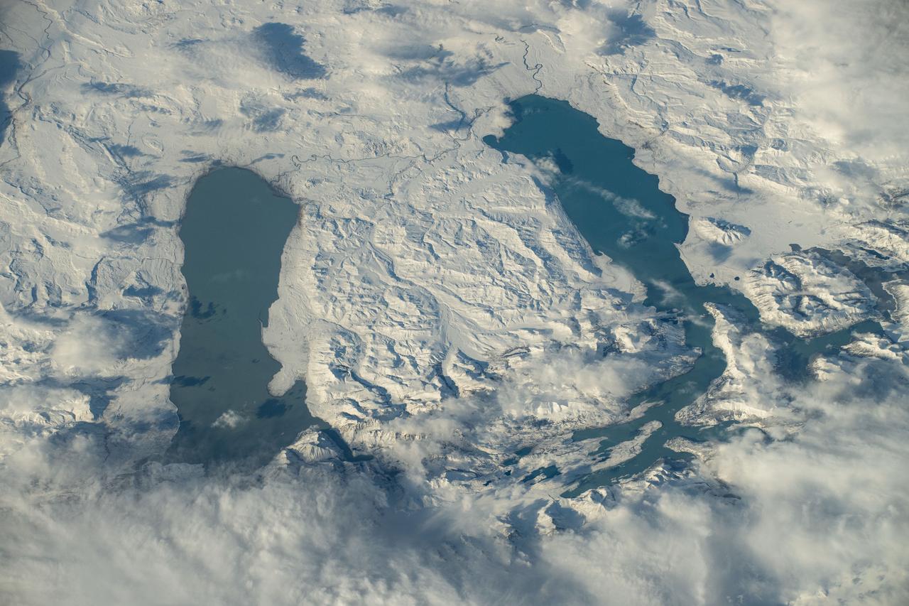
iss071e309961 (July 3, 2024) --In Southern Patagonia, two lakes run near parallel to one another, Viedma (left) and Argentino (right). The surrounding terrain is covered in snow around six months out of the year. Both lakes are fed by melting glacial ice by the nearby glaciers located in Los Glaciares National Park. As the International Space Station soared 272 miles above, NASA astronaut Butch Wilmore captured this photo.
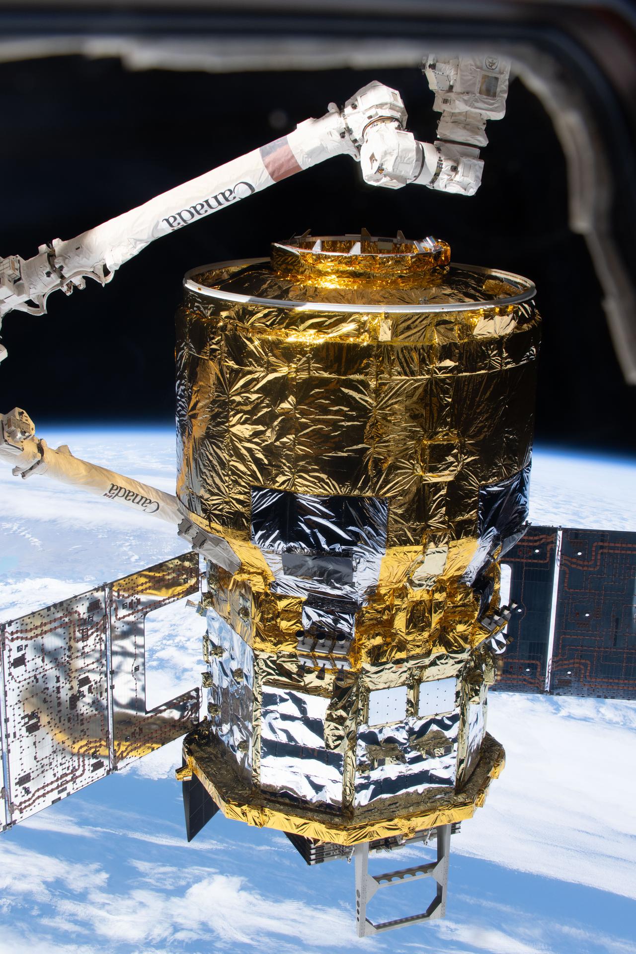
iss074e0364782 (March 5, 2026) --- The HTV‑X1 cargo spacecraft from JAXA (Japan Aerospace Exploration Agency) is in the grasp of the Canadarm2 robotic arm after being detached from the Earth‑facing port on the International Space Station’s Harmony module. The orbital outpost was soaring 274 miles above the Pacific Ocean off the coast of South America’s Patagonia region at the time of this photograph. Credit: NASA/Jessica Meir
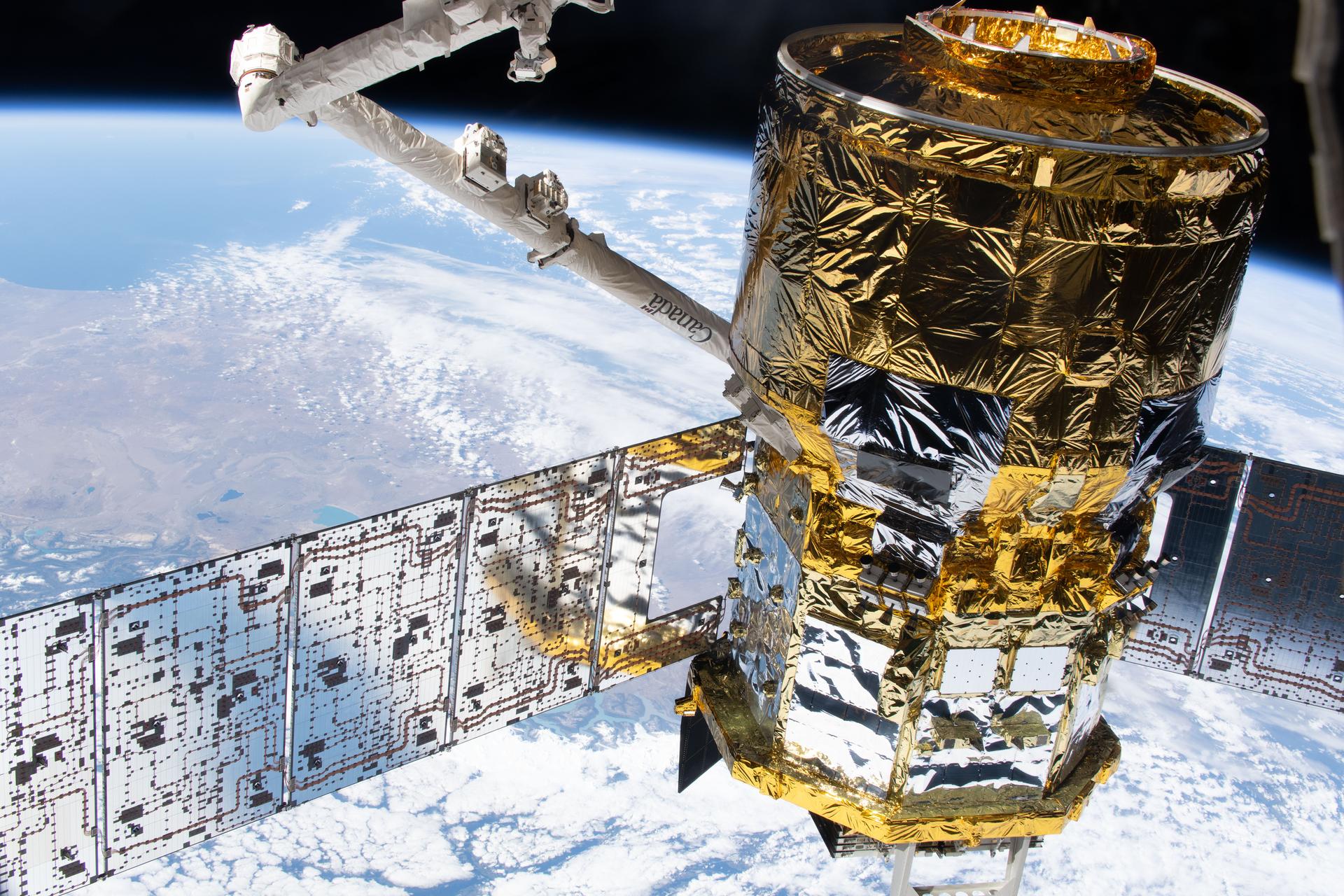
iss074e0364790 (March 5, 2026) --- The HTV‑X1 cargo spacecraft from JAXA (Japan Aerospace Exploration Agency) is in the grasp of the Canadarm2 robotic arm after being detached from the Earth‑facing port of the International Space Station’s Harmony module. The orbital outpost was soaring 274 miles above the Pacific Ocean off the coast of South America’s Patagonia region at the time of this photograph. Credit: NASA/Jessica Meir
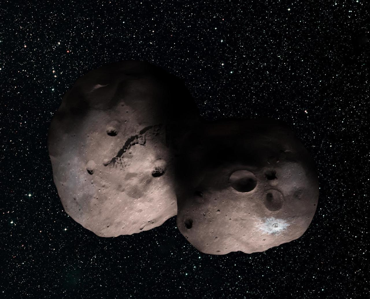
This is one artist's concept of Kuiper Belt object 2014 MU69, the next flyby target for NASA's New Horizons mission. This binary concept is based on telescope observations made at Patagonia, Argentina, on July 17, 2017, when MU69 passed in front of a star. New Horizons scientists theorize that it could be a single body with a large chunk taken out of it, or two bodies that are close together or even touching. https://photojournal.jpl.nasa.gov/catalog/PIA21867
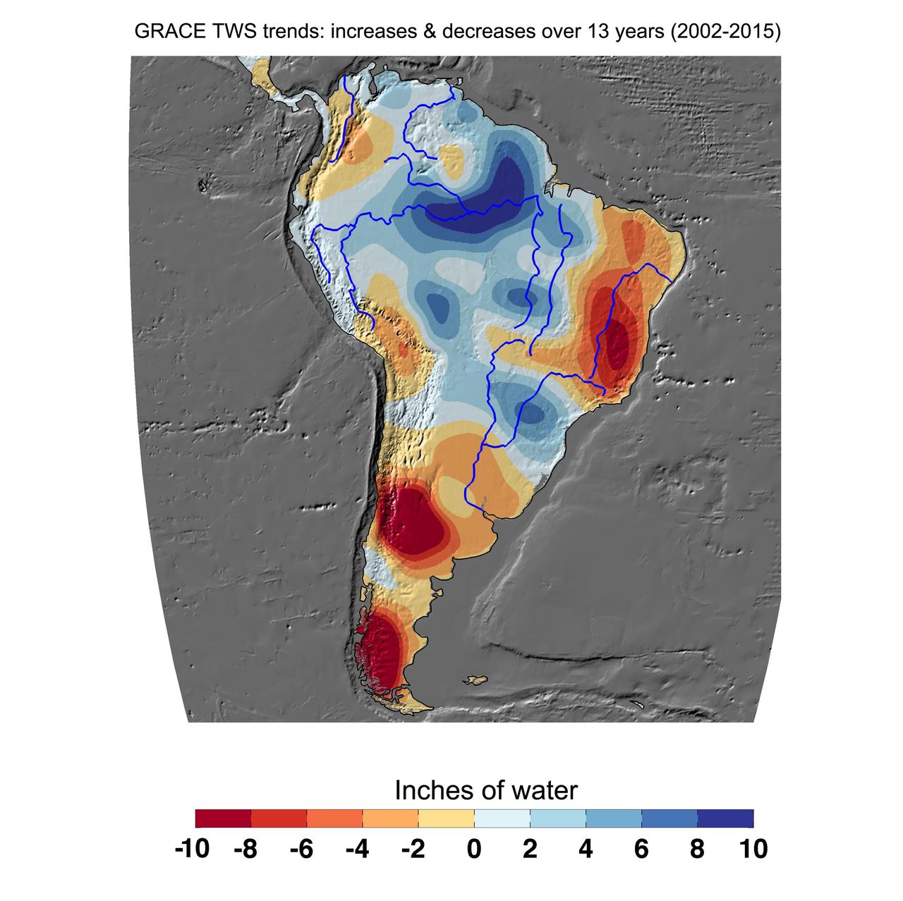
Cumulative total freshwater losses in South America from 2002 to 2015 (in inches) observed by NASA's Gravity Recovery and Climate Experiment (GRACE) mission. Total water refers to all of the snow, surface water, soil water and groundwater combined. Much of the Amazon River basin experienced increasing total water storage during this time period, though the persistent Brazilian drought is apparent to the east. Groundwater depletion strongly impacted total water losses in the Guarani aquifer of Argentina and neighboring countries. Significant water losses due to the melting ice fields of Patagonia are also observed. http://photojournal.jpl.nasa.gov/catalog/PIA20205
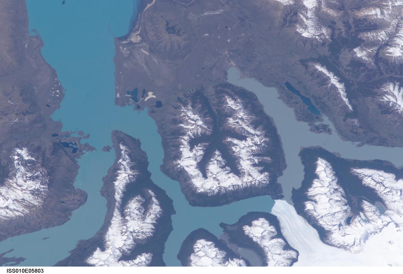
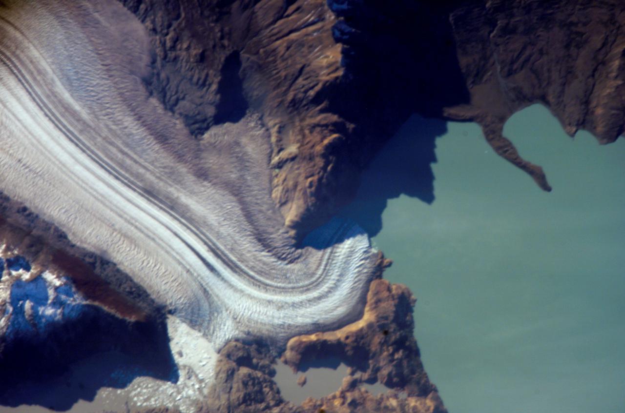
ISS037-E-005104 (2 Oct. 2013) --- Upsala Glacier Retreat and Patagonia Icefield are featured in this image photographed by an Expedition 37 crew member on the International Space Station. This photograph highlights the snout of the Upsala Glacier (49.88S 73.3W) on the Argentine side of the North Patagonian Icefield. Ice flow in this glacier (white mass, left) is from the north (left). Dark lines of rocky moraine within the ice give a sense of the slow ice flow from left to right. A smaller side glacier joins Upsala at the present-day ice front—the wall from which masses of ice periodically collapse into Lake Argentino. In this image the 2.75-kilometer-long wall casts a thin, dark shadow. The surface of Lake Argentino is whitened by a mass of ice debris from a recent collapse of the ice wall. Larger icebergs that have calved appear as white dots on the lake surface at right. Remotely sensed data, including detailed astronaut images such as this, have recorded the position of the ice front over the years. Even though the ice actually flows slowly southward, comparison of this October 2013 image with older data (not shown) indicates that the ice wall of the glacier has moved backwards—upstream—an average of 3.6 kilometers since early 2002. This so-called “retreat” is believed by scientists to indicate local climatic warming in this part of South America. The warming not only causes the ice front to retreat but more importantly, causes overall thinning of the glacier ice mass, as a study of 63 glaciers in Patagonia has shown is now a general trend (Rignot et al. 2003). Ice-front retreat is now known to be related to volumetric loss due to melting. Water color is related to glacier flow. Lake Argentino receives most of the ice from the glacier and thus also receives most of the “rock flour” (rocks ground to white powder by the ice scraping against the rock floor of the valley) from underneath the glacier. Glacial flour turns the lake water a gray-green hue in this image. The darker blue of the smaller lakes (top) indicates that they are receiving much less rock flour.
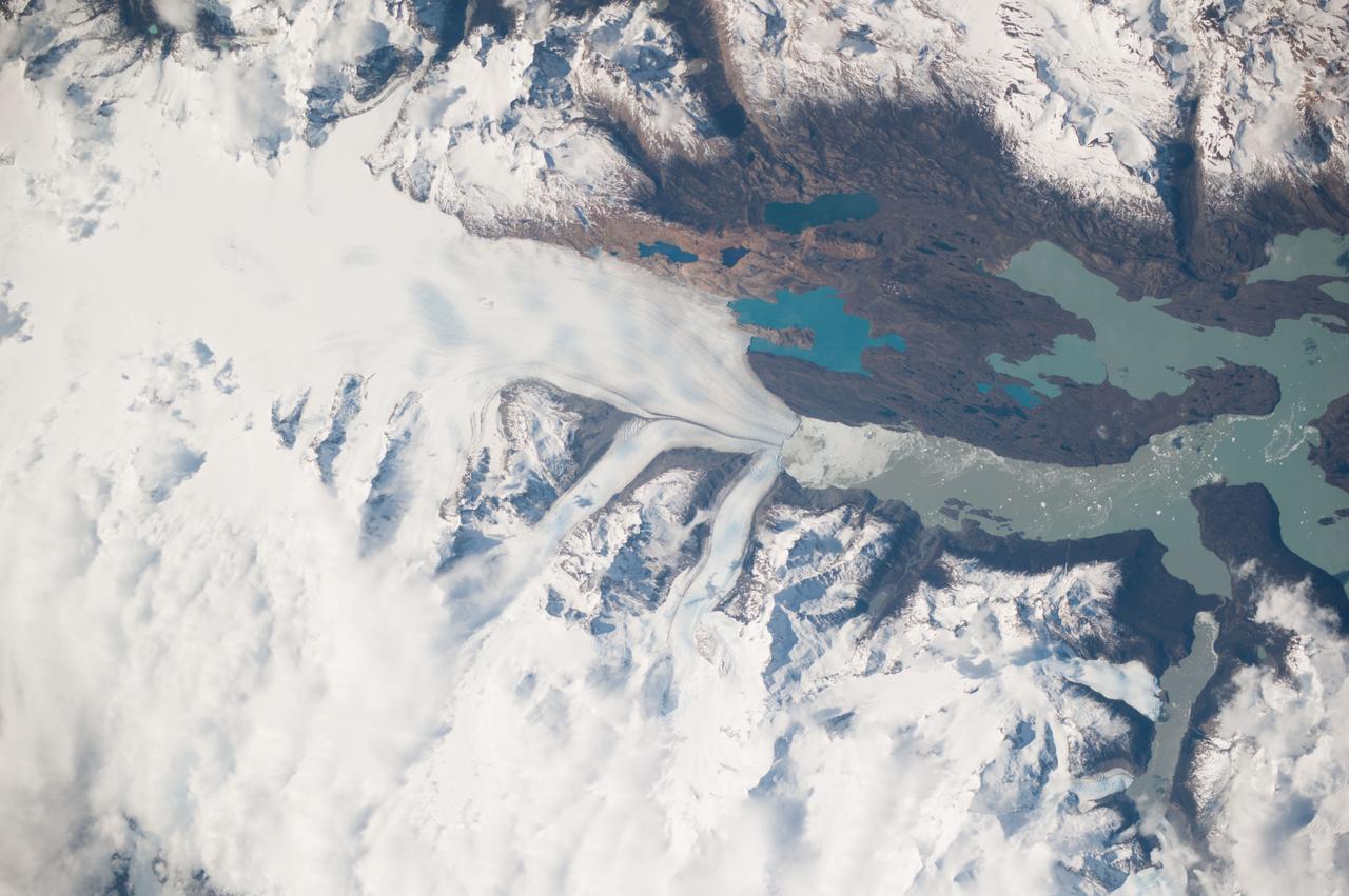
ISS010-E-05803 (4 November 2004) --- Moreno Glacier, Argentina is featured in this digital image photographed by an Expedition 10 crewmember on the International Space Station (ISS). Perito Moreno (or Moreno Glacier) is located in the ice fields of southern Patagonia and is the centerpiece of the Parque Nacional Los Glaciares. The glacier is also noteworthy as a tourist attraction, due to periodic formation of an ice dam between the main portion of Lago (Lake) Argentino to the northeast and a southern extension of the lake (Brazo Rico). NASA scientists studying the Space Station imagery made the following observations about the photo: Meltwater runoff from the surrounding mountains fills Brazo Rico to a higher elevation than nearby Lago Argentino and exerts hydrostatic pressure on the ice dam. This pressure leads to formation of drainage tunnels and fractures in the ice dam, which eventually fails. Earlier this year (March 2004) the ice dam collapsed in a spectacular show. A new ice dam across the Brazo Rico arm of Lago Argentino is visible in this image. The past extent of glaciations in the region is marked by several valleys formerly filled by flowing ice. A particularly striking example of this landscape feature is in the center of the image, where five glacial valleys converge to a central star-shaped outflow valley. Widespread recession of the glaciers in southern Patagonia has occurred over the last 30 years possibly due to warming of the regional climate. Contrary to this trend, Perito Moreno seems to be maintaining equilibrium between ice formation in the mountains and ice loss due to melting and calving into Lago Argentino.
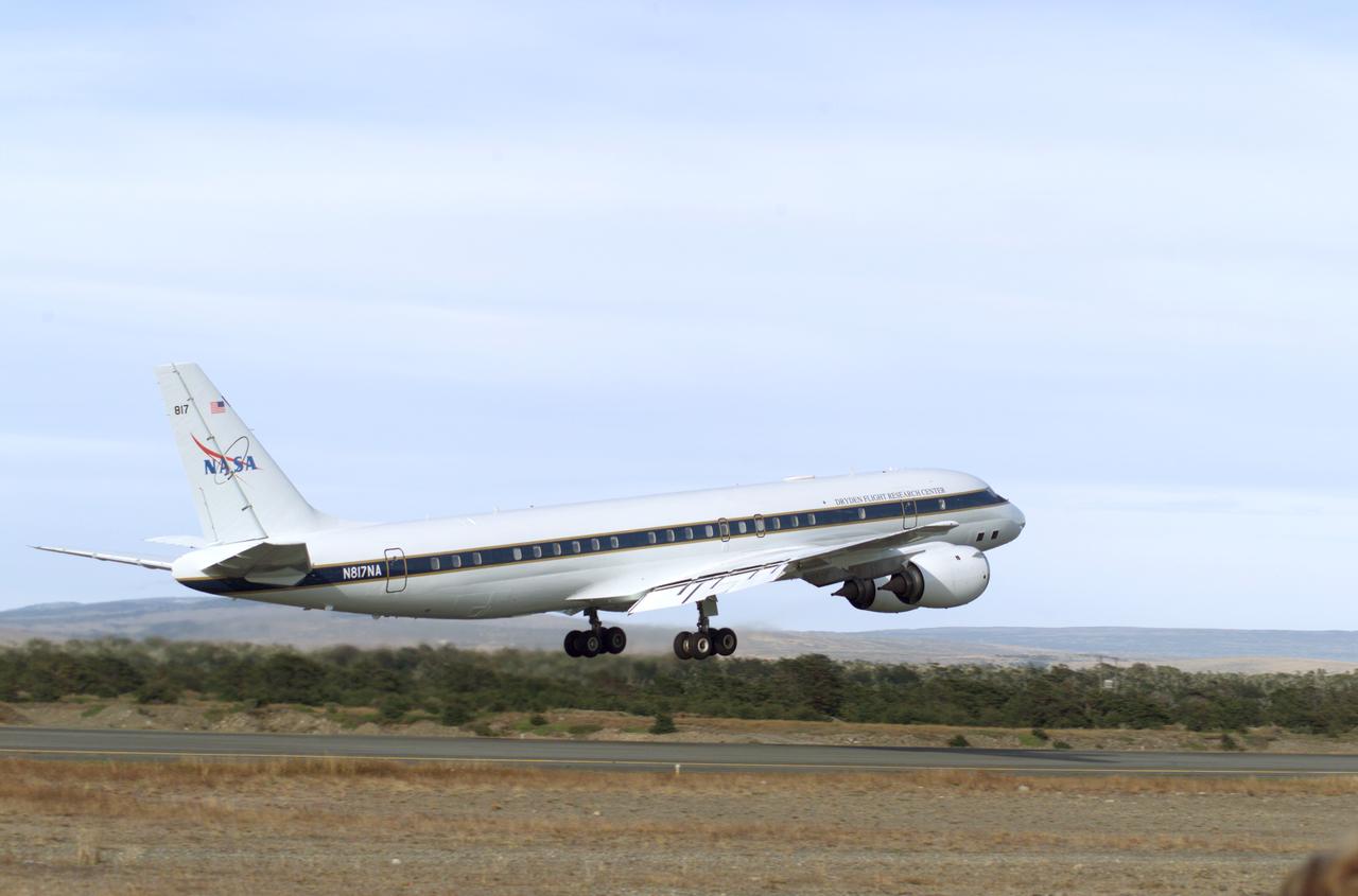
NASA's DC-8 flying laboratory takes off from Carlos Ibanez International Airport in Punta Arenas, Chile, during NASA's AirSAR 2004 campaign. AirSAR 2004 is a three-week expedition in Central and South America by an international team of scientists that is using an all-weather imaging tool, called the Airborne Synthetic Aperture Radar (AirSAR), located onboard NASA's DC-8 airborne laboratory. Scientists from many parts of the world are combining ground research with NASA's AirSAR technology to improve and expand on the quality of research they are able to conduct.
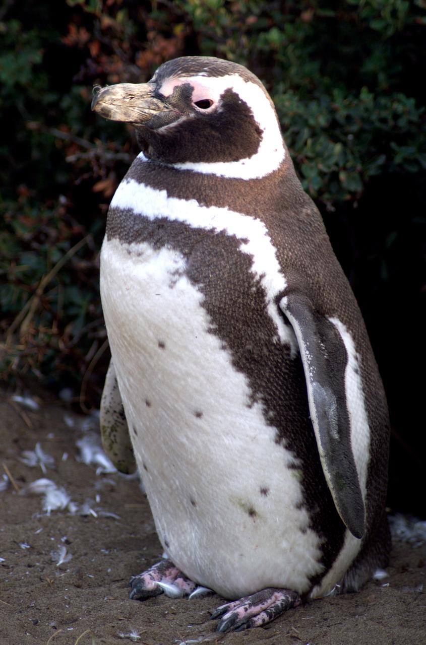
A penguin near Punta Arena, Chile, photographed in its natural summer habitat during NASA's AirSAR 2004 campaign. AirSAR 2004 is a three-week expedition in Central and South America by an international team of scientists that is using an all-weather imaging tool, called the Airborne Synthetic Aperture Radar (AirSAR), located onboard NASA's DC-8 airborne laboratory. Scientists from many parts of the world are combining ground research with NASA's AirSAR technology to improve and expand on the quality of research they are able to conduct.
NASA’s DC-8 aircraft prior to launch from Carlos Ibanez International Airport in Punta Arenas, Chile, during AirSAR 2004. AirSAR 2004 is a three-week expedition in Central and South America by an international team of scientists that is using an all-weather imaging tool, called the Airborne Synthetic Aperture Radar (AirSAR), located onboard NASA's DC-8 airborne laboratory. Scientists from many parts of the world are combining ground research with NASA's AirSAR technology to improve and expand on the quality of research they are able to conduct.

NASA’s DC-8 aircraft at Carlos Ibanez International Airport in Punta Arenas, Chile. A portion of AirSAR hardware is visible on the left rear fuselage. AirSAR 2004 is a three-week expedition in Central and South America by an international team of scientists that is using an all-weather imaging tool, called the Airborne Synthetic Aperture Radar (AirSAR), located onboard NASA's DC-8 airborne laboratory. Scientists from many parts of the world are combining ground research with NASA's AirSAR technology to improve and expand on the quality of research they are able to conduct.

Chilean Air Force Captain Saez and Dr. Tom Mace, DFRC Director of Airborne Sciences, discuss airborne science during a DC-8 ferry flight from Santiago to Punta Arenas, Chile. AirSAR 2004 is a three-week expedition by an international team of scientists that uses an all-weather imaging tool, called the Airborne Synthetic Aperture Radar (AirSAR) which is located onboard NASA's DC-8 airborne laboratory. Scientists from many parts of the world including NASA's Jet Propulsion Laboratory are combining ground research done in several areas in Central and South America with NASA's AirSAR technology to improve and expand on the quality of research they are able to conduct. In South America and Antarctica, AirSAR collected imagery and data to help determine the contribution of Southern Hemisphere glaciers to sea level rise due to climate change. In Patagonia, researchers found this contribution had more than doubled from 1995 to 2000, compared to the previous 25 years. AirSAR data will make it possible to determine whether that trend is continuing or accelerating. AirSAR will also provide reliable information on ice shelf thickness to measure the contribution of the glaciers to sea level.

L to R; NASA Dryden Mission Manager Walter Klein (in tan flight suit), JPL AirSAR Scientist Tim Miller, and Mission Manager David Bushman briefing press in Santiago, Chile, for NASA's AirSAR 2004 mission. AirSAR 2004 is a three-week expedition by an international team of scientists that uses an all-weather imaging tool, called the Airborne Synthetic Aperture Radar (AirSAR) which is located onboard NASA's DC-8 airborne laboratory. Scientists from many parts of the world including NASA's Jet Propulsion Laboratory are combining ground research done in several areas in Central and South America with NASA's AirSAR technology to improve and expand on the quality of research they are able to conduct. In South America and Antarctica, AirSAR collected imagery and data to help determine the contribution of Southern Hemisphere glaciers to sea level rise due to climate change. In Patagonia, researchers found this contribution had more than doubled from 1995 to 2000, compared to the previous 25 years. AirSAR data will make it possible to determine whether that trend is continuing or accelerating. AirSAR will also provide reliable information on ice shelf thickness to measure the contribution of the glaciers to sea level.
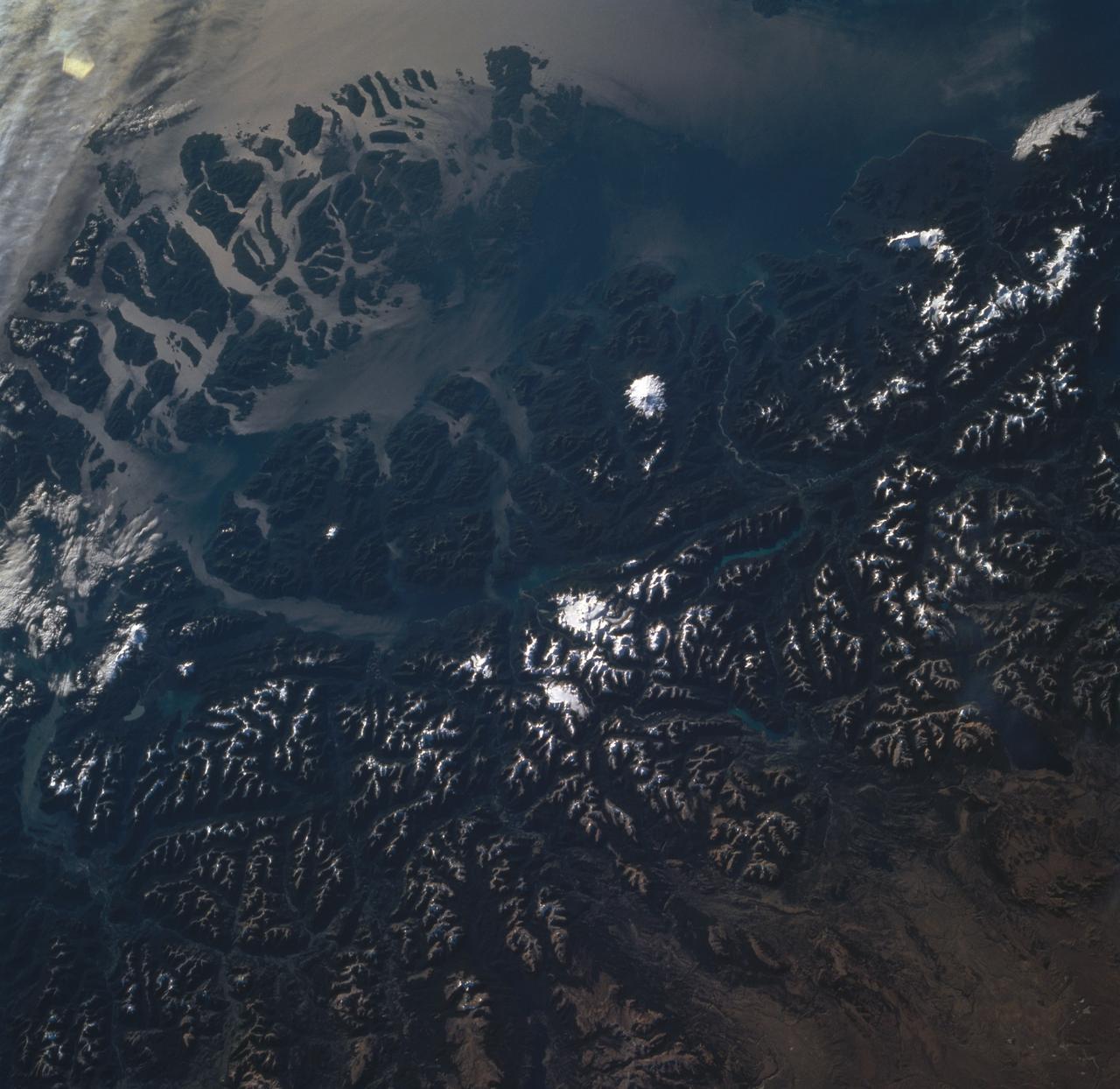
STS060-85-000AH (3-11 Feb 1994) --- This view is centered at about 44 degrees south along the Chilean continental margin of South America. The dark-colored coastal region is heavily forested by dense old-growth forests that are now being cut, but east of the mountains in Argentina the dry climate supports very little vegetation. This desert region known as Patagonia appears as light brown colors. The coastline is especially dramatic because it is shaped by the tortuous channels carved by glaciers which have left fjords. These fjords have effectively cut across the continental divide, and are bordered by active volcanoes which reach elevations between 2, 000 - 3,000 meters. The prominent volcanic peak in the center of the frame is Mt. Melimoya. To the north is a long, snow-covered volcanic ridge called Cerro Yantales. Cerro Yantales recently reported greatly increased fumarolic activity, including the emission of yellow gases near the summit. Russian and American scientists will use this photography to look for further evidence of increased activity like snow melt around the peak. Other Russian and American scientists are particularly interested in mapping the summertime snowline and firm (permanent snow field) elevations as early indications of any potential climatic variation in the making.

STS089-709-049 (22-31 Jan. 1998) --- This oblique photograph of Argentina and Chile was among several of South America photographed with a 70mm handheld camera from the Earth-orbiting space shuttle Endeavour. This part of Patagonia in Argentina and the lake district of Chile and Argentina are in southern South America between latitudes 40 degrees and 43 degrees. It is a beautiful alpine region noted for skiing and for the recent immigration of rich Americans and Europeans. On the west side of the Andes are a series of snow-capped volcanoes that are formed due to melting of sediments and portions of the Pacific Plate, which are being subducted beneath South America. East of the mountains the plains are barren and windswept, noted as having "the curse of sterility" by Charles Darwin. In the mountain regions some alpine valleys are filled by lovely lakes, such as Nahuel Huapi (in sunglint). The university town and ski resort of Bariloche, Argentina is the light area on the southeastern shore. In 1901 Robert Leroy Parker and Harry Longabaugh (aka Butch Cassidy and Sundance Kid) bought a ranch near the town of Cholila (lower left in the photo) with the proceeds of a robbery of the First National Bank of Winnemucca, Nevada. They lived there as successful ranchers until 1907, when they were reportedly forced to sell out and flee to Bolivia where their career ended at the hands of the Bolivian army. Photo credit: NASA

Pilot Bill Brockett (left) and Chilean Air Force Captain Saez with school children in the cockpit of NASA Dryden's DC-8 flying laboratory. Brockett explained NASA's AirSAR 2004 mission in Chile. AirSAR 2004 is a three-week expedition by an international team of scientists that uses an all-weather imaging tool, called the Airborne Synthetic Aperture Radar (AirSAR) which is located onboard NASA's DC-8 airborne laboratory. Scientists from many parts of the world including NASA's Jet Propulsion Laboratory are combining ground research done in several areas in Central and South America with NASA's AirSAR technology to improve and expand on the quality of research they are able to conduct. In South America and Antarctica, AirSAR collected imagery and data to help determine the contribution of Southern Hemisphere glaciers to sea level rise due to climate change. In Patagonia, researchers found this contribution had more than doubled from 1995 to 2000, compared to the previous 25 years. AirSAR data will make it possible to determine whether that trend is continuing or accelerating. AirSAR will also provide reliable information on ice shelf thickness to measure the contribution of the glaciers to sea level.

Dr. Tom Mace, NASA DFRC Director of Airborne Sciences, talks with a student from Punta Arenas, Chile, during a tour of the DC-8 aircraft while it was in the country supporting the AirSAR 2004 campaign. AirSAR 2004 is a three-week expedition by an international team of scientists that uses an all-weather imaging tool, called the Airborne Synthetic Aperture Radar (AirSAR) which is located onboard NASA's DC-8 airborne laboratory. Scientists from many parts of the world including NASA's Jet Propulsion Laboratory are combining ground research done in several areas in Central and South America with NASA's AirSAR technology to improve and expand on the quality of research they are able to conduct. In South America and Antarctica, AirSAR collected imagery and data to help determine the contribution of Southern Hemisphere glaciers to sea level rise due to climate change. In Patagonia, researchers found this contribution had more than doubled from 1995 to 2000, compared to the previous 25 years. AirSAR data will make it possible to determine whether that trend is continuing or accelerating. AirSAR will also provide reliable information on ice shelf thickness to measure the contribution of the glaciers to sea level.

NASA Dryden Mission Manager Walter Klein poses with school children that visited the DC-8 during AirSAR 2004 in Punta Arenas, Chile. AirSAR 2004 is a three-week expedition by an international team of scientists that uses an all-weather imaging tool, called the Airborne Synthetic Aperture Radar (AirSAR) which is located onboard NASA's DC-8 airborne laboratory. Scientists from many parts of the world including NASA's Jet Propulsion Laboratory are combining ground research done in several areas in Central and South America with NASA's AirSAR technology to improve and expand on the quality of research they are able to conduct. In South America and Antarctica, AirSAR collected imagery and data to help determine the contribution of Southern Hemisphere glaciers to sea level rise due to climate change. In Patagonia, researchers found this contribution had more than doubled from 1995 to 2000, compared to the previous 25 years. AirSAR data will make it possible to determine whether that trend is continuing or accelerating. AirSAR will also provide reliable information on ice shelf thickness to measure the contribution of the glaciers to sea level.

NASA Dryden Mission Manager Walter Klein talks with school children from Punta Arenas, Chile, during a tour of the DC-8 aircraft while it was in the country supporting the AirSAR 2004 campaign. AirSAR 2004 is a three-week expedition by an international team of scientists that uses an all-weather imaging tool, called the Airborne Synthetic Aperture Radar (AirSAR) which is located onboard NASA's DC-8 airborne laboratory. Scientists from many parts of the world including NASA's Jet Propulsion Laboratory are combining ground research done in several areas in Central and South America with NASA's AirSAR technology to improve and expand on the quality of research they are able to conduct. In South America and Antarctica, AirSAR collected imagery and data to help determine the contribution of Southern Hemisphere glaciers to sea level rise due to climate change. In Patagonia, researchers found this contribution had more than doubled from 1995 to 2000, compared to the previous 25 years. AirSAR data will make it possible to determine whether that trend is continuing or accelerating. AirSAR will also provide reliable information on ice shelf thickness to measure the contribution of the glaciers to sea level.

School children from Punta Arenas, Chile, talk with Dr. David Imel, an AirSAR scientist from NASA JPL, during AirSAR 2004. AirSAR 2004 is a three-week expedition by an international team of scientists that uses an all-weather imaging tool, called the Airborne Synthetic Aperture Radar (AirSAR) which is located onboard NASA's DC-8 airborne laboratory. Scientists from many parts of the world including NASA's Jet Propulsion Laboratory are combining ground research done in several areas in Central and South America with NASA's AirSAR technology to improve and expand on the quality of research they are able to conduct. In South America and Antarctica, AirSAR collected imagery and data to help determine the contribution of Southern Hemisphere glaciers to sea level rise due to climate change. In Patagonia, researchers found this contribution had more than doubled from 1995 to 2000, compared to the previous 25 years. AirSAR data will make it possible to determine whether that trend is continuing or accelerating. AirSAR will also provide reliable information on ice shelf thickness to measure the contribution of the glaciers to sea level.

STS113-708-014 (23 November - 7 December 2002) --- The STS-113 crewmembers used a handheld 70mm still camera to record this image of Patagonia lakes in southern Argentina. The lowest of the three lakes in this view is Lake Argentino. The next one north (middle lake) is Lake Viedma, and the lake on the top margin is Lake San Martín. According to NASA scientists studying the STS-113 Earth imagery, all three of these large lakes have been carved out by glaciers in the "recent" ice age, descending from the Andes Mountains (under cloud along the right side of the view). Three glacier tongues can be discerned as small white features leading into the western (left) ends of each lake. The rounded ends of the lakes, according to the Johnson Space Center scientists, are produced by the slow "flowing" action of glacial ice on the plains next to the mountain chain. Snow cap on lower peaks next to the cloud make a jagged pattern.
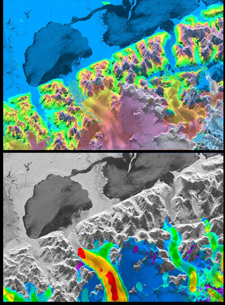
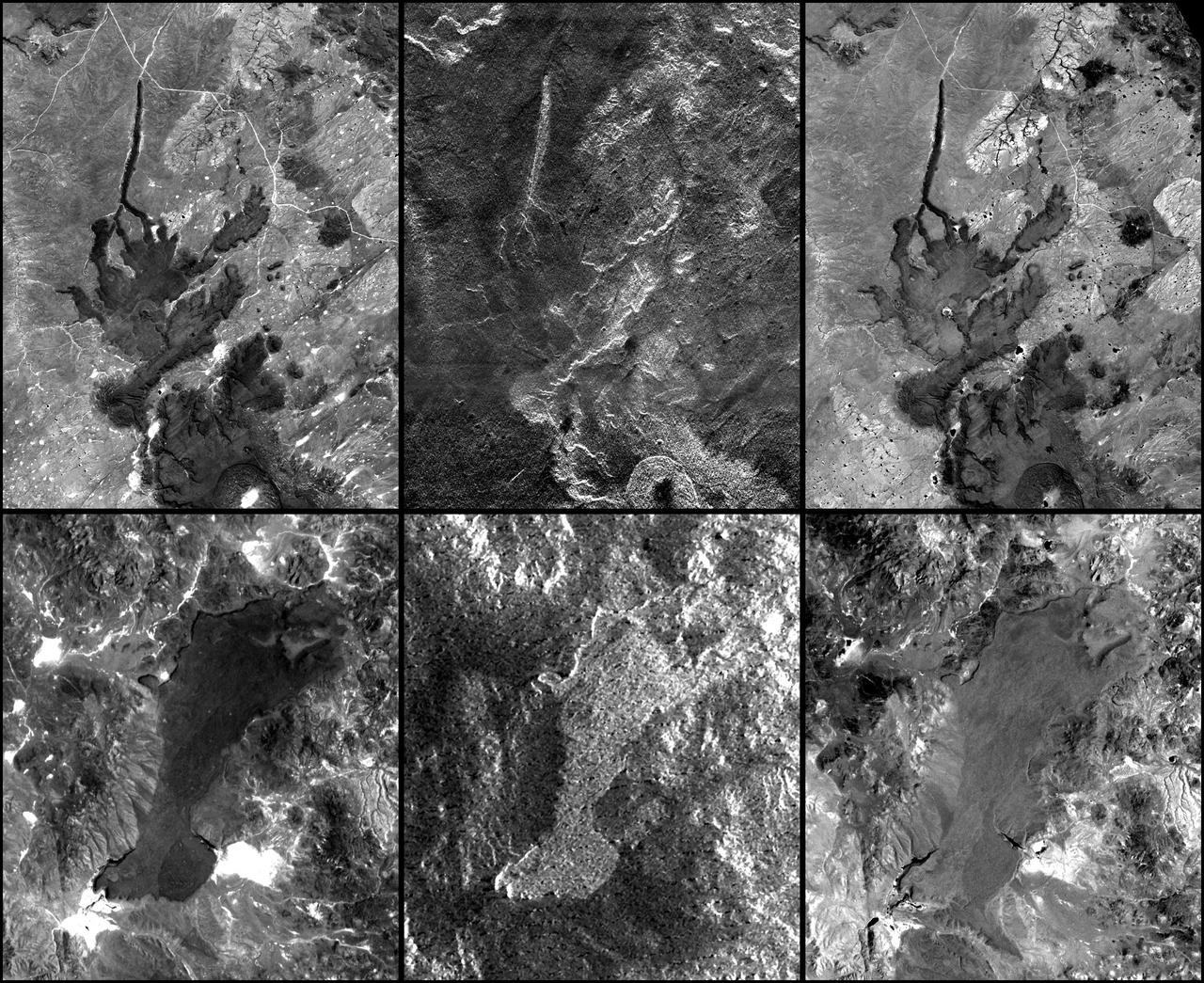
A NASA radar instrument has been successfully used to measure some of the fastest moving and most inaccessible glaciers in the world -- in Chile's huge, remote Patagonia ice fields -- demonstrating a technique that could produce more accurate predictions of glacial response to climate change and corresponding sea level changes. This image, produced with interferometric measurements made by the Spaceborne Imaging Radar-C and X-band Synthetic Aperture Radar (SIR-C/X-SAR) flown on the Space Shuttle last fall, has provided the first detailed measurements of the mass and motion of the San Rafael Glacier. Very few measurements have been made of the Patagonian ice fields, which are the world's largest mid-latitude ice masses and account for more than 60 percent of the Southern Hemisphere's glacial area outside of Antarctica. These features make the area essential for climatologists attempting to understand the response of glaciers on a global scale to changes in climate, but the region's inaccessibility and inhospitable climate have made it nearly impossible for scientists to study its glacial topography, meteorology and changes over time. Currently, topographic data exist for only a few glaciers while no data exist for the vast interior of the ice fields. Velocity has been measured on only five of the more than 100 glaciers, and the data consist of only a few single-point measurements. The interferometry performed by the SIR-C/X-SAR was used to generate both a digital elevation model of the glaciers and a map of their ice motion on a pixel-per-pixel basis at very high resolution for the first time. The data were acquired from nearly the same position in space on October 9, 10 and 11, 1994, at L-band frequency (24-cm wavelength), vertically transmitted and received polarization, as the Space Shuttle Endeavor flew over several Patagonian outlet glaciers of the San Rafael Laguna. The area shown in these two images is 50 kilometers by 30 kilometers (30 miles by 18 miles) in size and is centered at 46.6 degrees south latitude, 73.8 degrees west longitude. North is toward the upper right. The top image is a digital elevation model of the scene, where color and saturation represent terrain height (between 0 meters and 2,000 meters or up to 6,500 feet) and brightness represents radar backscatter. Low elevations are shown in blue and high elevations are shown in pink. The digital elevation map of the glacier surface has a horizontal resolution of 15 meters (50 feet) and a vertical resolution of 10 meters (30 feet). High-resolution maps like these acquired over several years would allow scientists to calculate directly long-term changes in the mass of the glacier. The bottom image is a map of ice motion parallel to the radar look direction only, which is from the top of the image. Purple indicates ice motion away from the radar at more than 6 centimeters per day; dark blue is ice motion toward or away at less than 6 cm per day; light blue is motion toward the radar of 6 cm to 20 cm (about 2 to 8 inches) per day; green is motion toward the radar of 20 cm to 45 cm (about 8 to 18 inches) per day; yellow is 45 cm to 85 cm (about 18 to 33 inches) per day; orange is 85 cm to 180 cm (about 33 to 71 inches) per day; red is greater than 180 cm (71 inches) per day. The velocity estimates are accurate to within 5 millimeters per day. The largest velocities are recorded on the San Rafael Glacier in agreement with previous work. Other outlet glaciers exhibit ice velocities of less than 1 meter per day. Several kilometers before its terminus, (left of center) the velocity of the San Rafael Glacier exceeds 10 meters (32 feet) per day, and ice motion cannot be estimated from the data. There, a revisit time interval of less than 12 hours would have been necessary to estimate ice motion from interferometry data. The results however demonstrate that the radar interferometry technique permits the monitoring of glacier characteristics unattainable by any other means. http://photojournal.jpl.nasa.gov/catalog/PIA01781
ISS030-E-091253 (21 Feb. 2012) --- Perito Moreno Glacier near Lake Argentino, Argentina is featured in this image photographed by an Expedition 30 crew member on the International Space Station. The largest glacier tongue in this image is known as the Perito Moreno Glacier (center). It descends from the Southern Patagonian Icefield (top) at great altitudes (greater than 2,100 meters, 6,825 feet) in the southern Andes Mountains, down into the water and warmer altitudes of Lake Argentino at approximately 180 meters above sea level. The glacier is 30 kilometers long (image width represents approximately 60 kilometers on the ground). Perito Moreno is one of the largest glaciers in Patagonia, and is perhaps the most famous for the fact that it periodically cuts off the major southern arm (known as Brazo Rico) of Lake Argentino completely from the rest of the lake. This is because the glacier advances right across the lake until it meets the opposite shoreline. The ice tongue is “grounded” (meaning that it is not floating, as occurs at the termini of glaciers and ice shelves where they enter the sea), thus forming a natural dam which prevents the lake water on either side from circulating, which in turn causes muddier, “milkier” water to concentrate in Brazo Rico. Sub-ice water, flows under the ice, not only carrying the mud into the lake but also helping lubricate the glacier’s downhill movement. Because of its effect as a dam, meltwater from the south raises water levels in Brazo Rico by as much as 30 meters above the level of the water in Lago Argentino. The great pressure of this higher water ultimately causes the ice tongue to rupture catastrophically, in a great natural spectacle. The last rupture took place in March 2012. The process then repeats, on average every four to five years, as the glacier starts to grow back towards the opposite shoreline. The repeatability of the rupture has contributed to the event becoming a major tourist attraction in the region.
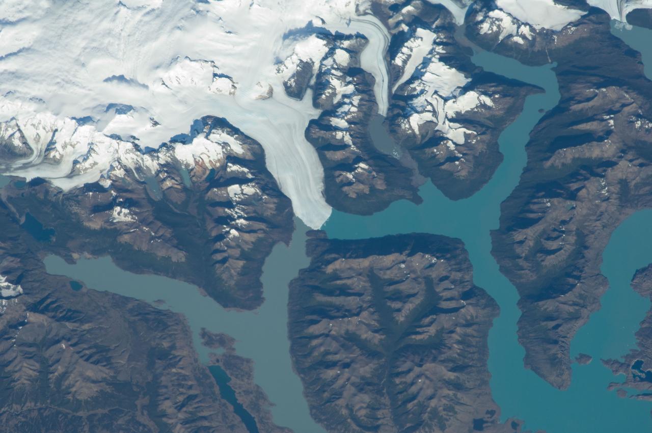
ISS013-E-06947 (12 April 2006) --- Viedma Glacier, Argentina is featured in this image photographed by an Expedition 13 crewmember on the International Space Station. The ice fields of Patagonia, located at the southern end of South America, are the largest masses of ice in the temperate Southern Hemisphere (approximately 55,000 square kilometers in area). The ice fields contain numerous valley glaciers that terminate in melt-water-fed lakes. These are known as "calving" glaciers, as they lose mass by collapse of large ice chunks from the terminus--or end--of the glacier. These newly separated chunks of ice are then free to float away, much like ice cubes in a punch bowl. The Patagonian glaciers are closely monitored using remotely sensed data as they respond to regional climate change. Visual comparison of time series of images is typically performed to quantify change in ice extent and position. The terminus of the Viedma Glacier, approximately two kilometers across where it enters Lake Viedma, is shown in this image. Moraines are accumulations of soil and rock debris that form along the sides and front of a glacier as it flows across the landscape (much like a bulldozer). Independent valley glaciers can merge together as they flow down-slope, and the moraines become entrained in the center of the new ice mass. These medial moraines are visible as dark parallel lines within the white central mass of the glacier (image center and left). Crevasses - oriented roughly perpendicular to the medial moraines - are also visible in the grey-brown ice along the sides of the glacier. According to scientists, the canyon-like crevasses form as a result of stress between the slower moving ice along the valley sides and the more rapidly moving ice in the center of the glacier. Calving of ice from the southwestern fork of the glacier terminus is visible at image lower left.
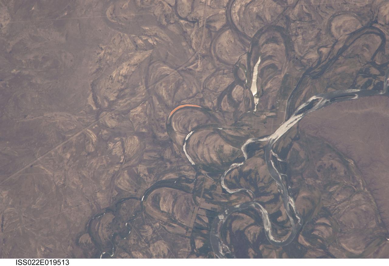
ISS022-E-019513 (4 Jan. 2010) --- The Rio Negro floodplain in Patagonia, Argentina is featured in this image photographed by an Expedition 22 crew member on the International Space Station. The Rio Negro is recognizable by astronaut crews from orbit as one of the most meandering rivers in South America. This is well illustrated in this view, where the entire river floodplain (approximately 10 kilometers wide) is covered with curved relics of channels known as meander scars. The main channel of the river, flowing south at this point?60 kilometers south of the city of Choele Choel (not shown)?appears in partial sun glint at right. Sun glint occurs when light is reflected off a water surface directly back towards the viewer, imparting a silvery sheen to those areas. When meander scars contain water they are known as oxbow lakes, some of which are also highlighted by sun glint in the image. Meander scars show the numerous past positions of river bends, produced as the river snaked across the plain in the very recent geological past. The Rio Negro is a dramatic example of how mobile a river can be. The orange tint to the water in one of the oxbow lakes (center) could result from orange salt-loving algae. Their appearance here would be unusual since floodplain lakes are usually too fresh for algae blooms. But an explanation may lie in the location of the Rio Negro on the margin of Argentina?s arid Patagonian region with annual rainfall less than 12 inches (300 mm). Evaporation in this cloudless region could be high enough for some lakes to become salty. The Rio Negro flows generally southeast from the Andes Mts. to the Atlantic Ocean. Its floodplain supports the biggest pear- and apple-growing region of Argentina. Rectangular farm boundaries can be seen at bottom center. The river also hosts the world?s longest kayak regatta (653 kilometers), which lasts six days.
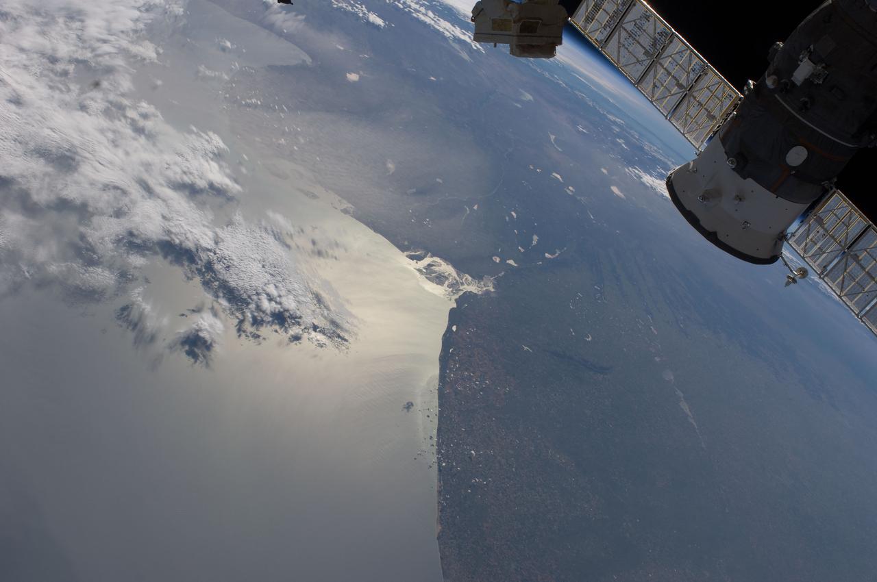
ISS030-E-005118 (22 Nov. 2011) --- A dust plume over the Bahia Blanca, Argentina is featured in this image photographed by an Expedition 30 crew member on the International Space Station. This panoramic view of eastern Argentina and the Atlantic coastline is centered near Bahia Blanca, which is also highlighted by sun glint. The oblique view looks generally westward (and downwards) from the orbital position of the space station towards a large plume of dust blowing southeastward from the interior and over the open Atlantic Ocean. The only significant cloud cover was located offshore (upper left). Northwestern and central Argentina are subject to frequent dust storms where a combination of extensive late Pleistocene loess?fine sediments deposited by wind and typically associated with former continental glaciers?and strong, dry westerly winds descending from the Andes, known locally as the pampero sucio, combine to produce sudden and extensive clouds of the fine soil. The particular dust event illustrated by the image covers much of the province of Rio Negro and the southern parts of the provinces of La Pampa and Buenos Aires as well as the coastal waters between the Gulf of San Matias (upper left) and Bahia Blanca (center), located approximately 330 kilometers to the northeast. The area illustrated by the image includes the agriculturally productive southern Pampas plain region where it transitions to the drier, less productive low hills and valleys of northern Patagonia. A docked Russian Progress spacecraft is visible at upper right.
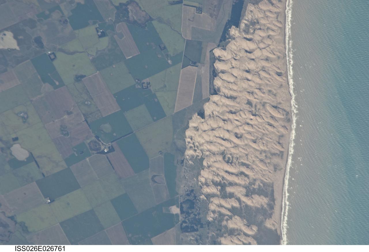
ISS026-E-026761 (13 Feb. 2011) --- Medano Blanco coastal dunes in Buenos Aires Province, Argentina are featured in this image photographed by an Expedition 26 crew member on the International Space Station. The Medano Blanco (White Dunes) are a well known recreational area 35 kilometers west of the twin cities of Nicochea-Quequen, one of the biggest ports in the province of Buenos Aires, central Argentina. The Medano Blanco dunes separate the Atlantic Ocean from intensive sunflower agricultural cropland, visible as the angular pattern of green and brown fields at left. The dune field extends 3.5 kilometers at its widest part. Narrow cordons of coastal dunes stretch along this part of Argentina’s coastline for hundreds of kilometers. Small streams, oriented towards the coast, cross the farmland at upper left. Water from these is dammed behind the dunes, and even within the dunes, where wetlands flourish. This is the drier southern part of Buenos Aires province near the more arid and windier border with Patagonia—one of the windiest places on Earth. The effect of strong westerly winds (blowing bottom to top in this slightly oblique image) can be seen everywhere in this detailed photograph. The dune sand is blown from local beaches onshore where it forms the dunes. The prominent dune ridge crests are oriented at right angles to the prevailing wind. Geologists suspect that erosion by wind has excavated numerous hollows which now dot the farmland as small shallow lakes. A stand of dark green trees has been planted on the upwind side of a health spa—located at the white dot (center left) which is the roof of a stately building—as a protective barrier against the wind. The white fringe along the seashore is formed from lines of breaking waves. Crossing swell trains can be seen offshore in the Atlantic Ocean. The curvature of the swell pattern offshore also shows the effect of the westerly wind, and indeed drives the local sea current in this area—slightly more prominent onshore swells approach the coast from the southeast. The light brown tint of seawater nearer the shore is the fine muddy fraction of the coastal sediment being washed seaward (after being stirred up by wave action) and then east by the current.
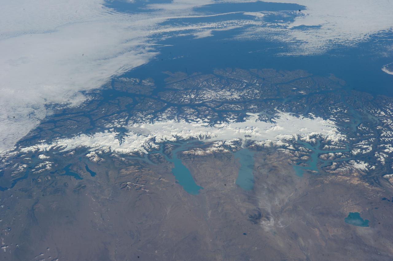
ISS038-E-047324 (13 Feb. 2014) --- This grand panorama of the Southern Patagonia Icefield (center) was imaged by an Expedition 38 crew member on the International Space Station on one of the rare clear days in the southern Andes Mountains. With an area of 13,000 square kilometers, the icefield is the largest temperate ice sheet in the Southern Hemisphere. Storms that swirl into the region from the southern Pacific Ocean (top) bring rain and snow (equivalent to a total of 2-11 meters of rainfall per year) resulting in the buildup of the ice sheet shown here (center). During the ice ages the glaciers were far larger. Geologists now know that ice tongues extended far onto the plains in the foreground, completely filling the great Patagonian lakes on repeated occasions. Similarly, ice tongues extended into the dense network of fjords (arms of the sea) on the Pacific side of the icefield. Ice tongues today appear tiny compared to the view that an "ice age" astronaut would have seen. A study of the surface topography of sixty-three glaciers, based on Shuttle Radar Topography Mission (SRTM) data, compared data from 2000 to data from studies going back about 30 years (1968-1975). Many glacier tongues showed significant annual "retreat" of their ice fronts, a familiar signal of climate change. The study also revealed that the almost invisible loss by glacier thinning is far more significant in explaining ice loss. The researchers concluded that volume loss by frontal collapse is 4-10 times smaller than that caused by thinning. Scaled over the entire icefield, including frontal loss (so-called calving when ice masses collapse into the lakes), it was calculated that 13.5 cubic kilometers of ice was lost each year over the study period. This number becomes more meaningful compared with the rate measured in the last five years of the study (1995-2000), when the rate increased almost threefold, averaging 38.7 cubic kilometers per year. Extrapolating results from the low altitude glacier tongues implies that the high plateau ice on the spine of the Andes is thinning as well. In the decade since this study the often-imaged Upsala Glacier has retreated a further three kilometers, as shown recently in images taken by crew members aboard the space station. Glacier Pio X, named for Pope Pius X, is the only large glacier that is growing in length.