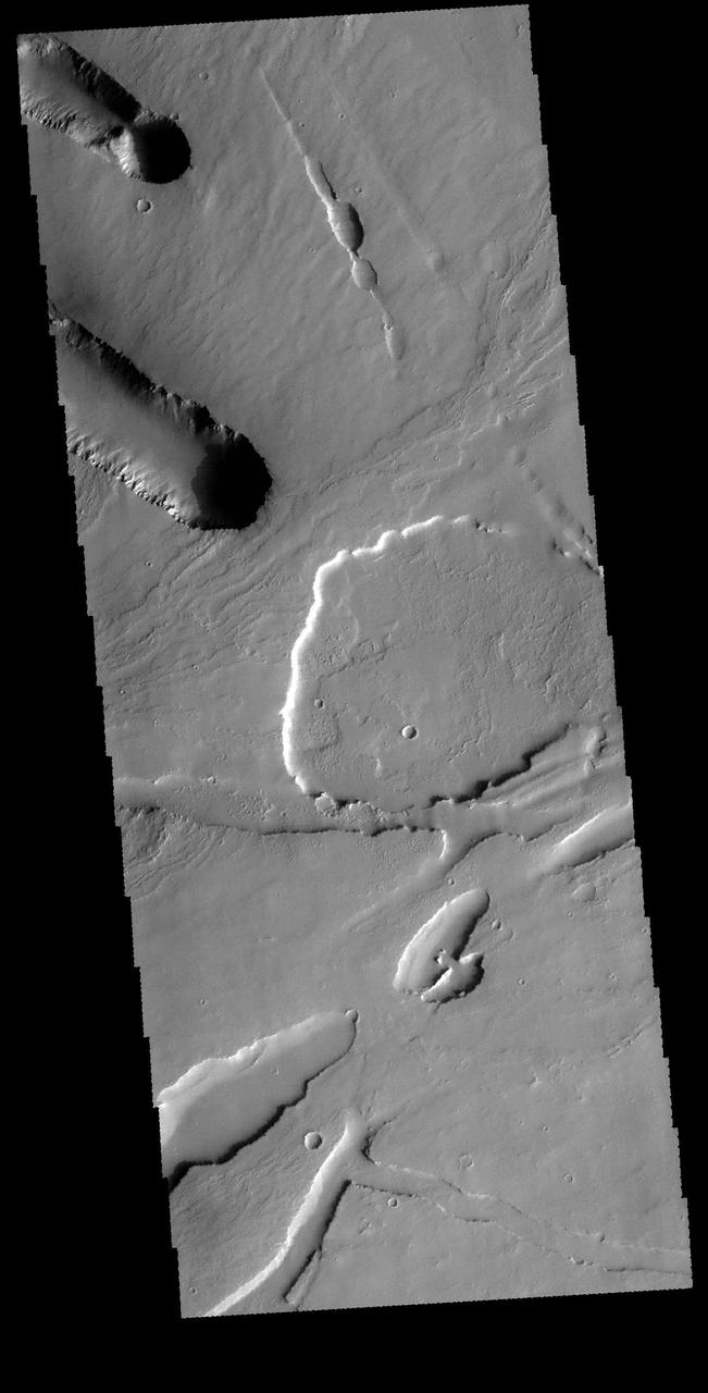
This VIS image shows part of the area where Pavonis Chasma intersects with Pavonis Fossae. It is a region of lava flows from Pavonis Mons and depressions likely formed by collapse into lava tubes and tectonic graben. Orbit Number: 65596 Latitude: 3.32631 Longitude: 249.947 Instrument: VIS Captured: 2016-09-27 00:55 http://photojournal.jpl.nasa.gov/catalog/PIA21160
The two depression crossing this image are called Pavonis Fossae and are located just north of the volcano in this image captured by NASA 2001 Mars Odyssey spacecraft.

The two depression crossing this image are called Pavonis Fossae and are located on the northern lower flank of Pavonis Mons. These linear features are most likely created by a combination of both tectonic and volcanic forces. The top feature has several narrow 'walls' within the depression, indicating a collapse of the roof of an empty lava tube. Pavonis Mons is the central volcano of the three large Tharsis volcanoes. All three volcanoes form a line located along a tectonic bulge caused by extensional forces in the region. Pavonis Mons is the smallest of the three with a summit of only 14km (8.7 miles). Orbit Number: 90136 Latitude: 3.50046 Longitude: 249.786 Instrument: VIS Captured: 2022-04-10 02:31 https://photojournal.jpl.nasa.gov/catalog/PIA25472

The windstreaks in this image from NASA 2001 Mars Odyssey spacecraft are located on the lava plains between Pavonis Mons and Noctis Fossae.
![The linear features in this VIS image are called Oti Fossae. Oti Fossae is located on the eastern flank of Arsia Mons and aligns with the regional northeast/southwest trend of the major Tharsis volcanoes. Graben are formed by extension of the crust and faulting. When large amounts of pressure or tension are applied to rocks on timescales that are fast enough that the rock cannot respond by deforming, the rock breaks along faults. In the case of a graben, two parallel faults are formed by extension of the crust and the rock in between the faults drops downward into the space created by the extension. The crustal deformation in this region was from the inflation of the surface by the rise of magma that created the Tharsis volcanoes. Arsia Mons is the southernmost and youngest of the three large, aligned Tharsis volcanoes [Arsia Mons, Pavonis Mons and Ascreaus Mons, from south to north]. This alignment may indicate a large fracture/vent system was responsible for the eruptions that formed all three volcanoes. Arsia Mons is 270 miles (450km) in diameter, almost 12 miles (20km) high, and the summit caldera is 72 miles (120km) wide. For comparison, the largest volcano on Earth is Mauna Loa. From its base on the sea floor, Mauna Loa measures only 6.3 miles high and 75 miles in diameter. Orbit Number: 89712 Latitude: -8.73951 Longitude: 243.785 Instrument: VIS Captured: 2022-03-06 04:33 https://photojournal.jpl.nasa.gov/catalog/PIA25392](https://images-assets.nasa.gov/image/PIA25392/PIA25392~medium.jpg)
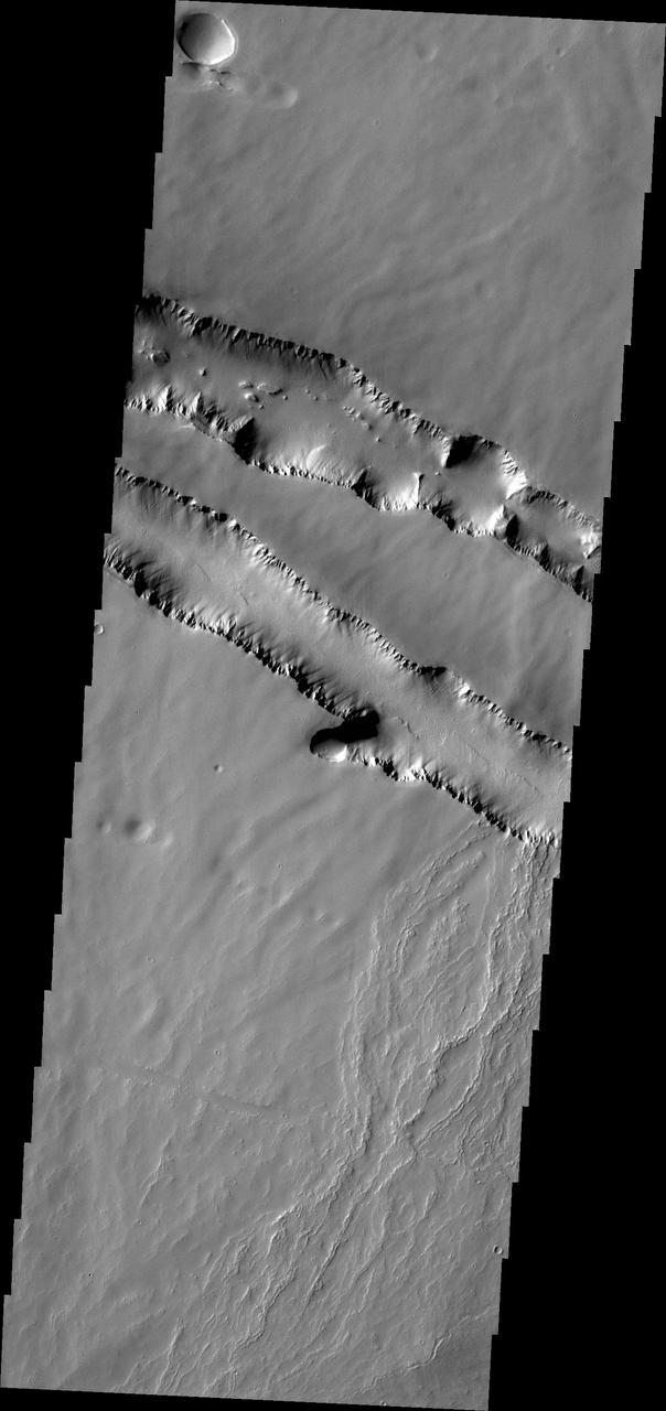
The linear features in this VIS image are called Oti Fossae. Oti Fossae is located on the eastern flank of Arsia Mons and aligns with the regional northeast/southwest trend of the major Tharsis volcanoes. Graben are formed by extension of the crust and faulting. When large amounts of pressure or tension are applied to rocks on timescales that are fast enough that the rock cannot respond by deforming, the rock breaks along faults. In the case of a graben, two parallel faults are formed by extension of the crust and the rock in between the faults drops downward into the space created by the extension. The crustal deformation in this region was from the inflation of the surface by the rise of magma that created the Tharsis volcanoes. Arsia Mons is the southernmost and youngest of the three large, aligned Tharsis volcanoes [Arsia Mons, Pavonis Mons and Ascreaus Mons, from south to north]. This alignment may indicate a large fracture/vent system was responsible for the eruptions that formed all three volcanoes. Arsia Mons is 270 miles (450km) in diameter, almost 12 miles (20km) high, and the summit caldera is 72 miles (120km) wide. For comparison, the largest volcano on Earth is Mauna Loa. From its base on the sea floor, Mauna Loa measures only 6.3 miles high and 75 miles in diameter. Orbit Number: 89712 Latitude: -8.73951 Longitude: 243.785 Instrument: VIS Captured: 2022-03-06 04:33 https://photojournal.jpl.nasa.gov/catalog/PIA25392
![The linear features in the bottom half of this VIS image are called Oti Fossae. Oti Fossae is located on the eastern flank of Arsia Mons and aligns with the regional northeast/southwest trend of the major Tharsis volcanoes. Fossae are typically tectonic features termed graben. Graben are formed by extension of the crust and faulting. When large amounts of pressure or tension are applied to rocks on timescales that are fast enough that the rock cannot respond by deforming, the rock breaks along faults. In the case of a graben, two parallel faults are formed by extension of the crust and the rock in between the faults drops downward into the space created by the extension. The crustal deformation in this region was from the inflation of the surface by the rise of magma that created the Tharsis volcanoes. Arsia Mons is the southernmost and youngest of the three large, aligned Tharsis volcanoes [Arsia Mons, Pavonis Mons and Ascreaus Mons, from south to north]. This alignment may indicate a large fracture/vent system was responsible for the eruptions that formed all three volcanoes. Arsia Mons is 270 miles (450km) in diameter, almost 12 miles (20km) high, and the summit caldera is 72 miles (120km) wide. For comparison, the largest volcano on Earth is Mauna Loa. From its base on the sea floor, Mauna Loa measures only 6.3 miles high and 75 miles in diameter. Orbit Number: 94404 Latitude: -8.85515 Longitude: 242.188 Instrument: VIS Captured: 2023-03-27 12:39 https://photojournal.jpl.nasa.gov/catalog/PIA26025](https://images-assets.nasa.gov/image/PIA26025/PIA26025~medium.jpg)
The linear features in the bottom half of this VIS image are called Oti Fossae. Oti Fossae is located on the eastern flank of Arsia Mons and aligns with the regional northeast/southwest trend of the major Tharsis volcanoes. Fossae are typically tectonic features termed graben. Graben are formed by extension of the crust and faulting. When large amounts of pressure or tension are applied to rocks on timescales that are fast enough that the rock cannot respond by deforming, the rock breaks along faults. In the case of a graben, two parallel faults are formed by extension of the crust and the rock in between the faults drops downward into the space created by the extension. The crustal deformation in this region was from the inflation of the surface by the rise of magma that created the Tharsis volcanoes. Arsia Mons is the southernmost and youngest of the three large, aligned Tharsis volcanoes [Arsia Mons, Pavonis Mons and Ascreaus Mons, from south to north]. This alignment may indicate a large fracture/vent system was responsible for the eruptions that formed all three volcanoes. Arsia Mons is 270 miles (450km) in diameter, almost 12 miles (20km) high, and the summit caldera is 72 miles (120km) wide. For comparison, the largest volcano on Earth is Mauna Loa. From its base on the sea floor, Mauna Loa measures only 6.3 miles high and 75 miles in diameter. Orbit Number: 94404 Latitude: -8.85515 Longitude: 242.188 Instrument: VIS Captured: 2023-03-27 12:39 https://photojournal.jpl.nasa.gov/catalog/PIA26025
![The linear features in the bottom half of this VIS image are called Oti Fossae. Oti Fossae is located on the eastern flank of Arsia Mons and aligns with the regional northeast/southwest trend of the major Tharsis volcanoes. Fossae are typically tectonic features termed graben. Graben are formed by extension of the crust and faulting. When large amounts of pressure or tension are applied to rocks on timescales that are fast enough that the rock cannot respond by deforming, the rock breaks along faults. In the case of a graben, two parallel faults are formed by extension of the crust and the rock in between the faults drops downward into the space created by the extension. The crustal deformation in this region was from the inflation of the surface by the rise of magma that created the Tharsis volcanoes. Arsia Mons is the southernmost and youngest of the three large, aligned Tharsis volcanoes [Arsia Mons, Pavonis Mons and Ascreaus Mons, from south to north]. This alignment may indicate a large fracture/vent system was responsible for the eruptions that formed all three volcanoes. Arsia Mons is 270 miles (450km) in diameter, almost 12 miles (20km) high, and the summit caldera is 72 miles (120km) wide. For comparison, the largest volcano on Earth is Mauna Loa. From its base on the sea floor, Mauna Loa measures only 6.3 miles high and 75 miles in diameter. Orbit Number: 94978 Latitude: -8.70852 Longitude: 242.873 Instrument: VIS Captured: 2023-05-13 18:56 https://photojournal.jpl.nasa.gov/catalog/PIA26224](https://images-assets.nasa.gov/image/PIA26224/PIA26224~medium.jpg)
The linear features in the bottom half of this VIS image are called Oti Fossae. Oti Fossae is located on the eastern flank of Arsia Mons and aligns with the regional northeast/southwest trend of the major Tharsis volcanoes. Fossae are typically tectonic features termed graben. Graben are formed by extension of the crust and faulting. When large amounts of pressure or tension are applied to rocks on timescales that are fast enough that the rock cannot respond by deforming, the rock breaks along faults. In the case of a graben, two parallel faults are formed by extension of the crust and the rock in between the faults drops downward into the space created by the extension. The crustal deformation in this region was from the inflation of the surface by the rise of magma that created the Tharsis volcanoes. Arsia Mons is the southernmost and youngest of the three large, aligned Tharsis volcanoes [Arsia Mons, Pavonis Mons and Ascreaus Mons, from south to north]. This alignment may indicate a large fracture/vent system was responsible for the eruptions that formed all three volcanoes. Arsia Mons is 270 miles (450km) in diameter, almost 12 miles (20km) high, and the summit caldera is 72 miles (120km) wide. For comparison, the largest volcano on Earth is Mauna Loa. From its base on the sea floor, Mauna Loa measures only 6.3 miles high and 75 miles in diameter. Orbit Number: 94978 Latitude: -8.70852 Longitude: 242.873 Instrument: VIS Captured: 2023-05-13 18:56 https://photojournal.jpl.nasa.gov/catalog/PIA26224
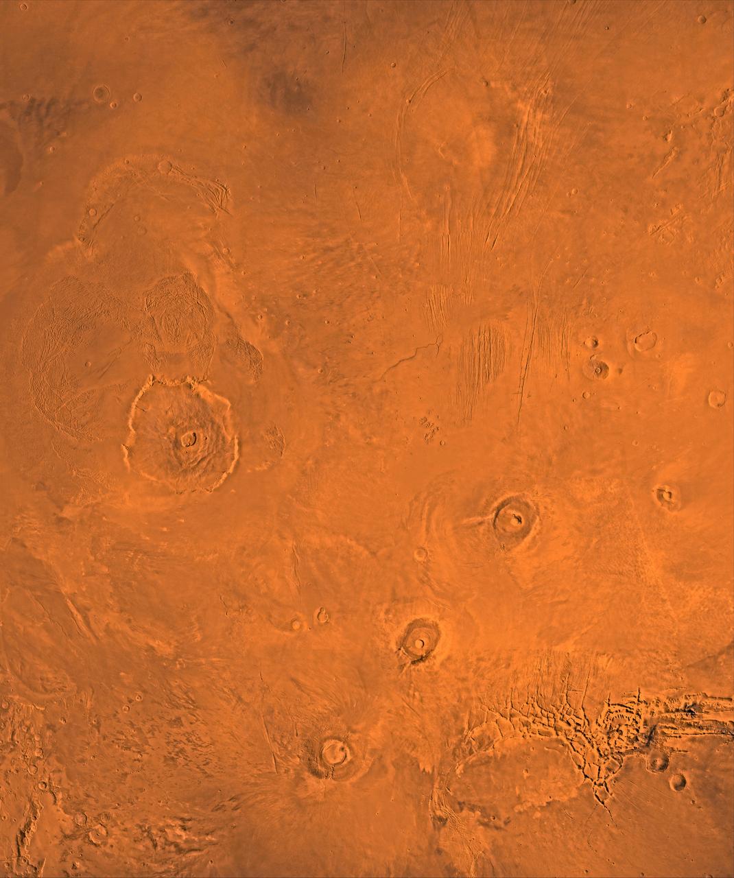
A color image of the Tharsis region of Mars; north toward top. The scene shows the Tharsis bulge, a huge ridge covered by the 3 large aligned Tharsis Montes shield volcanoes (from lower left to right): Arsia, Pavonis, and Ascraeus Mons. To the left of the Tharsis Montes lies the huge Olympus Mons shield volcano, followed clockwise by Alba Patera (north center), several smaller volcanoes, and the linear depressions of Mareotis and Tempe Fossae (upper right). This image is a composite of Viking medium-resolution images in black and white and low-resolution images in color. The image extends from latitude 50 degrees N. to 20 degrees S. and from longitude 85 degrees to 150 degrees. Mercator projection is used between latitudes 20 degrees S. and 30 degrees N.; Lambert projection is used above latitude 30 degrees N. The Tharsis bulge encompasses the most intensely and most recently active volcanic region of the planet. Each Tharsis Montes volcano is 350-400 km in diameter and about 17 km above the surrounding plain. The volcanoes are about 700 km apart and appear to be above a major northeast-trending fracture zone along the bulge, now buried by volcanic deposits. Olympus Mons (left center) is the largest known volcano in the Solar System. It is 27 km high, over 600 km at the base, and is surrounded by a well-defined scarp that is up to 6 km high. The summit calderas (central depressions) of all four volcanoes probably formed from recurrent collapse following drainage of magma resulting from flank eruptions. 1,600-km-diameter Alba Patera (north center) far exceeds any other known volcano in areal extent; it covers eight times the area of Olympus Mons but reaches only about 6 km in height. Fossae (linear depressions) of the Tharsis area are fault-bound graben formed by upwarping of the Tharsis bulge. http://photojournal.jpl.nasa.gov/catalog/PIA00408