Pavonis Mons

Pavonis Mons
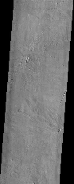
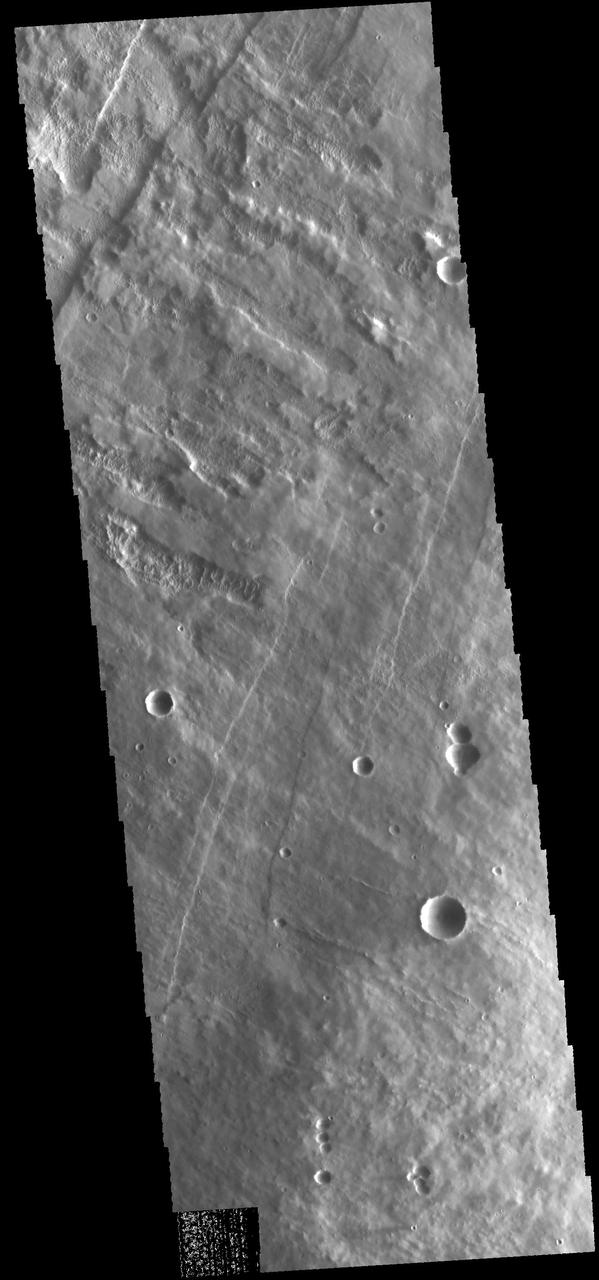
Pavonis Mons Features
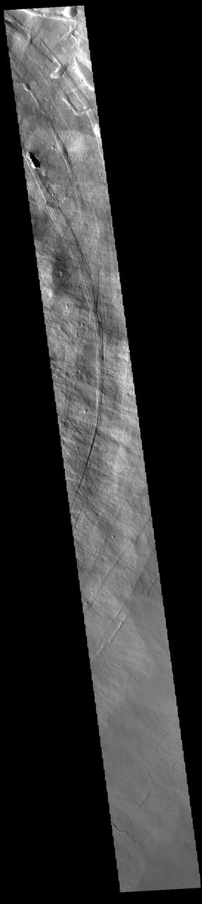
Pavonis Mons Aureole
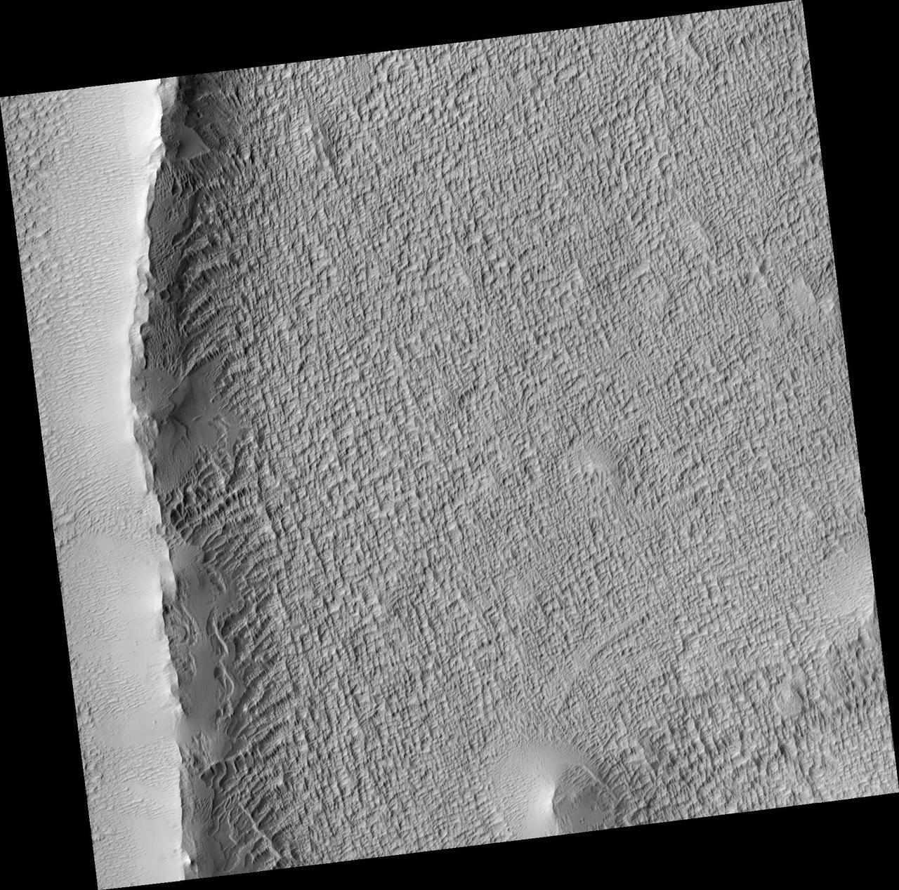
Work of Wind on Pavonis Mons
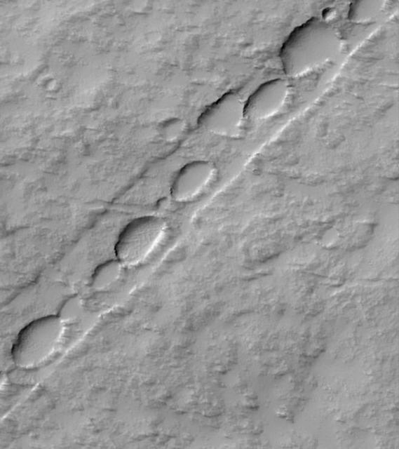
Chain of Pits on Pavonis Mons
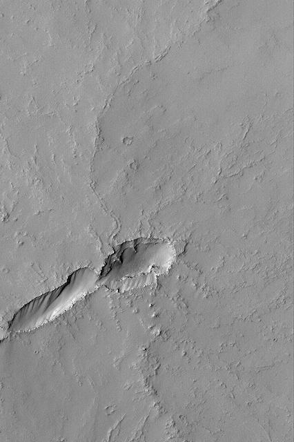
Volcano Near Pavonis Mons
This VIS image shows a cross section of Pavonis Mons. Pavonis Mons is the central volcano of the three large Tharsis volcanoes. In order from north to south the volcanoes are Ascreaus Mons, Pavonis Mons and Arsia Mons. All three volcanoes form a line located along a tectonic bulge caused by extensional forces in the region. Along this trend there are increased tectonic features and additional lava flows that arose from the flanks of the volcanoes rather than just the summit. Like the other large volcanoes in the region, Pavonis Mons is a shield volcano. Shield volcanoes are formed by lava flows originating near or at the summit, building up layers upon layers of lava. In shield volcanoes summit calderas are typically formed where the surface collapses into the void formed by an emptied magma chamber. Pavonis Mons is the smallest of the three volcanoes with a summit of only 14km (8.7 miles) and a width of 375 km (233 miles). Like most shield volcanoes the surface has a low profile. In the case of Pavonis Mons the average slope is only 4 degrees. Pavonis means peacock in Latin, making its name peacock mountain. Orbit Number: 94828 Latitude: 0.739028 Longitude: 248.934 Instrument: VIS Captured: 2023-05-01 10:34 https://photojournal.jpl.nasa.gov/catalog/PIA26180
Lava Flows near Pavonis Mons
Dust Mantle Near Pavonis Mons
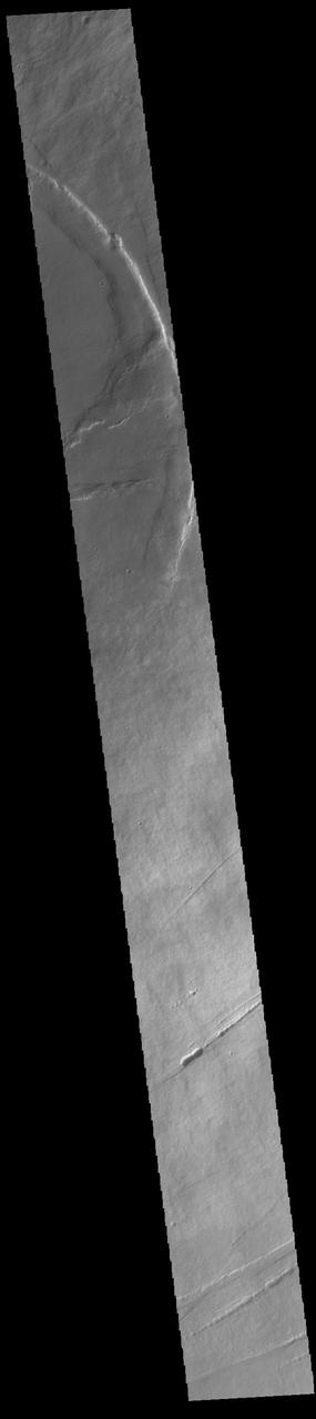
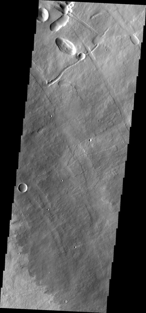
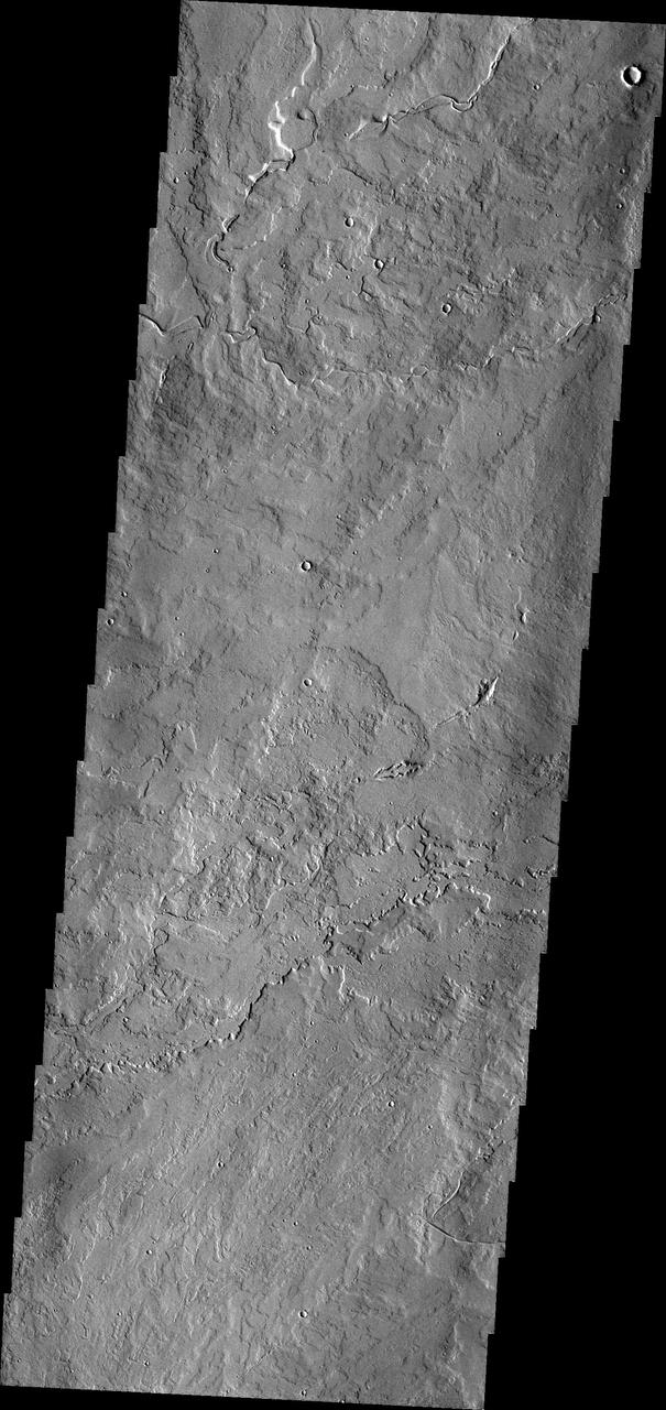
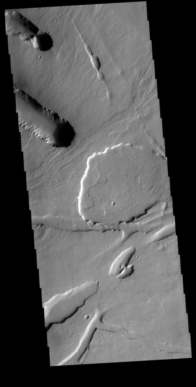
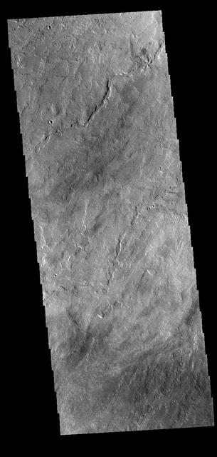
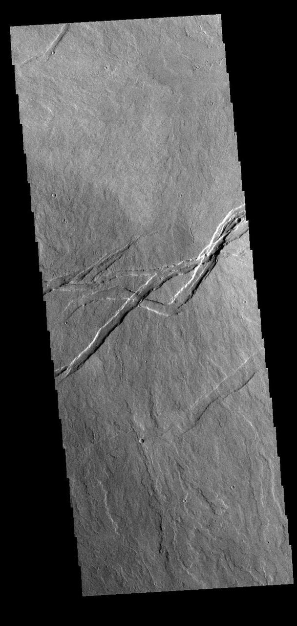
This VIS image shows part of the eastern flank of Pavonis Mons. Pavonis Mons is the central volcano of the three large Tharsis volcanoes. All three volcanoes form a line located along a tectonic bulge caused by extensional forces in the region. Pavonis Mons is the smallest of the three with a summit of only 14km (8.7 miles). The linear features in the image are concentric faults. Pavonis means peacock in Latin, making the name peacock mountain. Orbit Number: 86667 Latitude: 1.2754 Longitude: 249.141 Instrument: VIS Captured: 2021-06-28 11:12 https://photojournal.jpl.nasa.gov/catalog/PIA24960
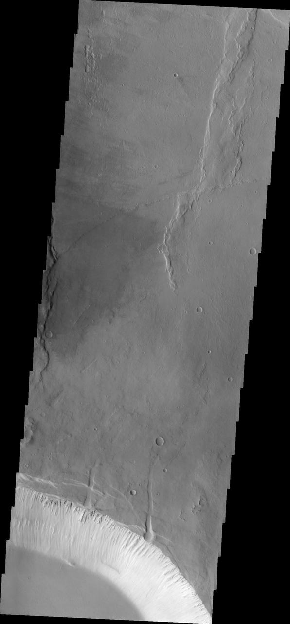
This VIS image shows part of the southwestern flank of Pavonis Mons. Pavonis Mons is the central volcano of the three large Tharsis volcanoes. All three volcanoes form a line located along a tectonic bulge caused by extensional forces in the region. Pavonis Mons is the smallest of the three with a summit of only 14km (46,000 ft). The linear features in the image are concentric faults. Pavonis means peacock in Latin, making the name peacock mountain. Orbit Number: 78194 Latitude: -0.288861 Longitude: 248.551 Instrument: VIS Captured: 2019-07-31 19:21 https://photojournal.jpl.nasa.gov/catalog/PIA23446
This image captured by NASA Mars Odyssey shows a portion of the flank of Pavonis Mons.
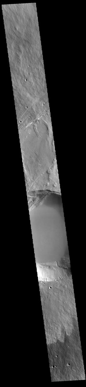
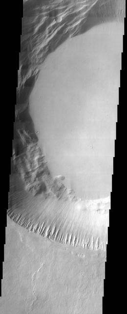
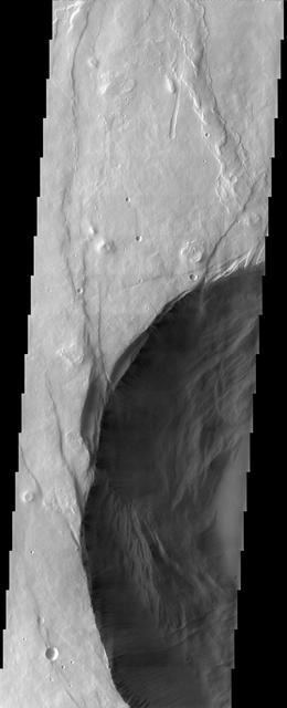
This VIS image shows a cross section of Pavonis Mons, including part of the summit caldera (circular region near the top of the image). Pavonis Mons is the central volcano of the three large Tharsis volcanoes. In order from north to south the volcanoes are Ascreaus Mons, Pavonis Mons and Arsia Mons. All three volcanoes form a line located along a tectonic bulge caused by extensional forces in the region. Along this trend there are increased tectonic features and additional lava flows that arose from the flanks of the volcanoes rather than just the summit. Like the other large volcanoes in the region, Pavonis Mons is a shield volcano. Shield volcanoes are formed by lava flows originating near or at the summit, building up layers upon layers of lava. In shield volcanoes summit calderas are typically formed where the surface collapses into the void formed by an emptied magma chamber. Pavonis Mons is the smallest of the three volcanoes with a summit of only 14km (8.7 miles) and a width of 375 km (233 miles). Like most shield volcanoes the surface has a low profile. In the case of Pavonis Mons the average slope is only 4 degrees. Pavonis means peacock in Latin, making it's name peacock mountain. Orbit Number: 91047 Latitude: 0.277333 Longitude: 248.096 Instrument: VIS Captured: 2022-06-24 02:47 https://photojournal.jpl.nasa.gov/catalog/PIA25540

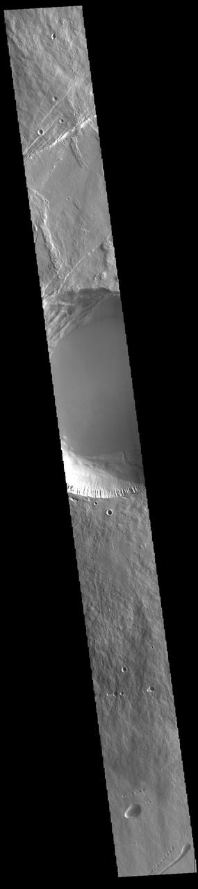
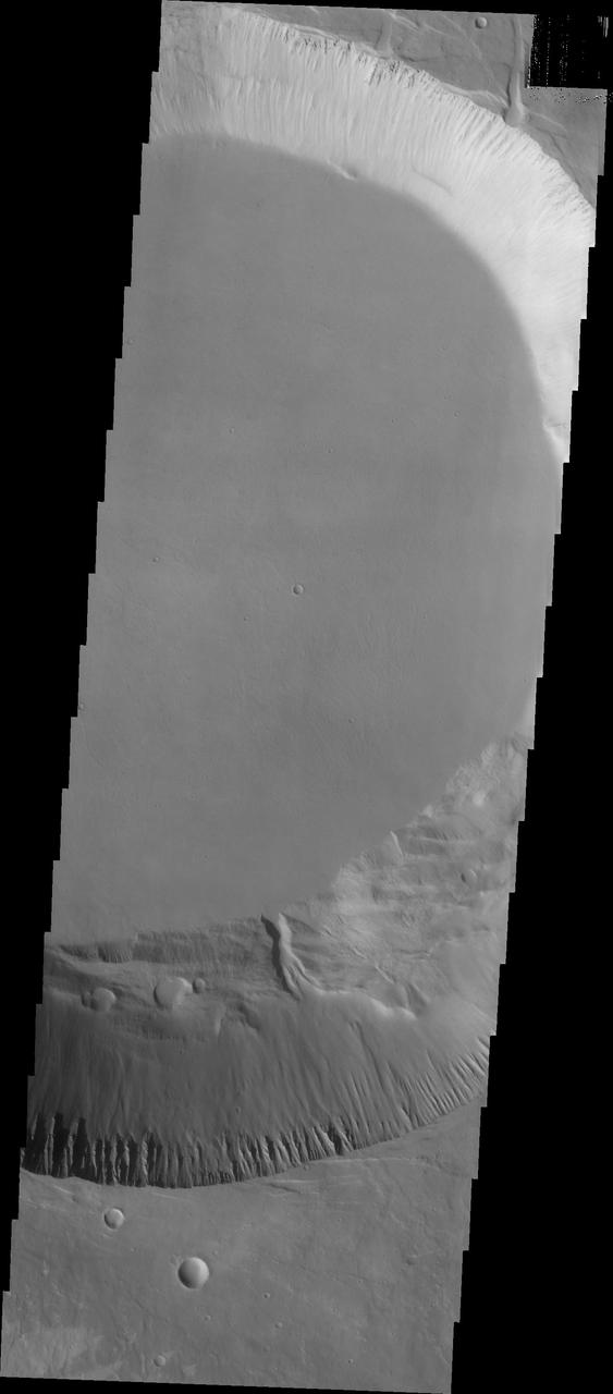
This VIS image shows a cross section of Pavonis Mons, including part of the summit caldera (circular region in the middle of the image). Pavonis Mons is the central volcano of the three large Tharsis volcanoes. In order from north to south the volcanoes are Ascreaus Mons, Pavonis Mons and Arsia Mons. All three volcanoes form a line located along a tectonic bulge caused by extensional forces in the region. Along this trend there are increased tectonic features and additional lava flows that arose from the flanks of the volcanoes rather than just the summit. Like the other large volcanoes in the region, Pavonis Mons is a shield volcano. Shield volcanoes are formed by lava flows originating near or at the summit, building up layers upon layers of lava. In shield volcanoes summit calderas are typically formed where the surface collapses into the void formed by an emptied magma chamber. Pavonis Mons is the smallest of the three volcanoes with a summit of only 14km (8.7 miles) and a width of 375 km (233 miles). Like most shield volcanoes the surface has a low profile. In the case of Pavonis Mons the average slope is only 4 degrees. Pavonis means peacock in Latin, making it's name peacock mountain. Orbit Number: 89612 Latitude: 0.716663 Longitude: 247.469 Instrument: VIS Captured: 2022-02-25 22:59 https://photojournal.jpl.nasa.gov/catalog/PIA25403
This VIS image shows a cross section of the upper elevations of Pavonis Mons, including part of the summit caldera (circular region near the center of the image). Pavonis Mons is the central volcano of the three large Tharsis volcanoes. In order from north to south the volcanoes are Ascreaus Mons, Pavonis Mons and Arsia Mons. All three volcanoes form a line located along a tectonic bulge caused by extensional forces in the region. Along this trend there are increased tectonic features and additional lava flows that arose from the flanks of the volcanoes rather than just the summit. Like the other large volcanoes in the region, Pavonis Mons is a shield volcano. Shield volcanoes are formed by lava flows originating near or at the summit, building up layers upon layers of lava. In shield volcanoes summit calderas are typically formed where the surface collapses into the void formed by an emptied magma chamber. Pavonis Mons is the smallest of the three volcanoes with a summit of only 14km (8.7 miles) and a width of 375 km (233 miles). Like most shield volcanoes the surface has a low profile. In the case of Pavonis Mons the average slope is only 4 degrees. Pavonis means peacock in Latin, making it's name peacock mountain. Orbit Number: 92650 Latitude: 0.705474 Longitude: 247.87 Instrument: VIS Captured: 2022-11-03 03:34 https://photojournal.jpl.nasa.gov/catalog/PIA25768
This image captured by NASA 2001 Mars Odyssey spacecraft shows part of the western flank of Pavonis Mons.
This image from NASA 2001 Mars Odyssey shows the eastern flank of Pavonis Mons.
This image from NASA Mars Odyssey shows a portion of the northeastern flank of Pavonis Mons, one of the large Tharsis volcanoes.
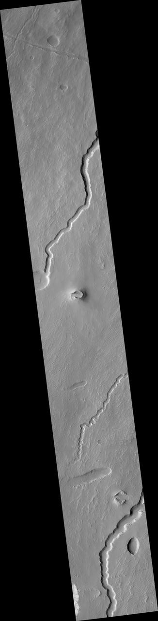
The small channels seen in this image from NASA 2001 Mars Odyssey spacecraft are lava channels just southeastern of Pavonis Mons.
This image from NASA 2001 Mars Odyssey spacecraft shows the southern margin of Pavonis Mons.
This image from NASA 2001 Mars Odyssey spacecraft shows the summit caldera of Pavonis Mons.
The lava flows in this image captured by NASA 2001 Mars Odyssey spacecraft originated at Pavonis Mons.
Radial Ridge in Deposit Near Pavonis Mons
Possible Cinder Cone on the Southern Flank of Pavonis Mons
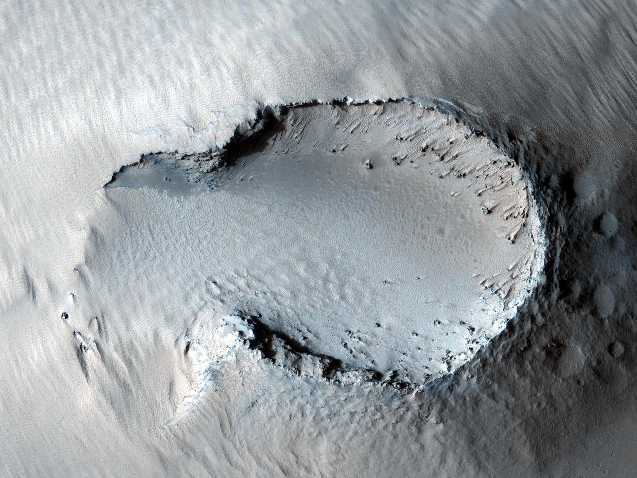
Public-Requested Mars Image: Crater on Pavonis Mons
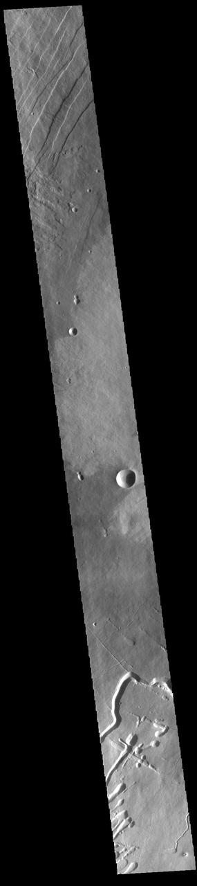
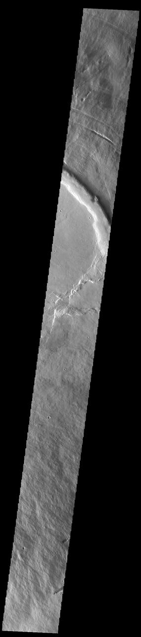
This VIS image shows part of the western flank of Pavonis Mons. Pavonis Mons is the central volcano of the three large Tharsis volcanoes. All three volcanoes form a line located along a tectonic bulge caused by extensional forces in the region. Pavonis Mons is the smallest of the three with a summit of only 14km (46,000 ft). The linear features at the top of the image are concentric faults. The linear and sinuous channel-like features at the bottom of the image likely formed by collapse of the roof of lava tubes into the empty space beneath. Pavonis means peacock in Latin, making the name peacock mountain. Orbit Number: 89637 Latitude: 0.453403 Longitude: 246.269 Instrument: VIS Captured: 2022-02-28 00:23 https://photojournal.jpl.nasa.gov/catalog/PIA25454
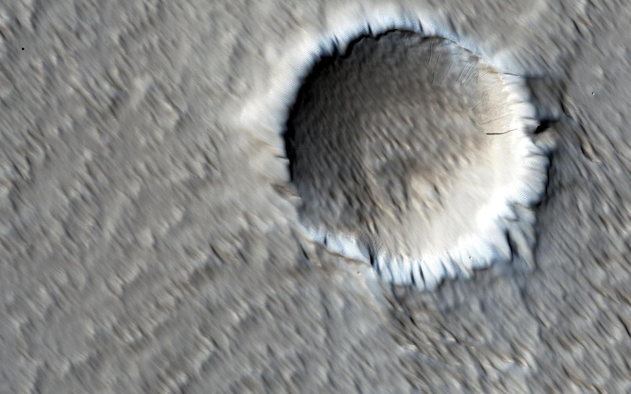
Click on the image for larger version This image shows a circular impact crater and an oval volcanic caldera on the southern flank of a large volcano on Mars called Pavonis Mons. The caldera is also the source of numerous finger-like lava flows and at least one sinuous lava channel. Both the caldera and the crater are degraded by aeolian (wind) erosion. The strong prevailing winds have apparently carved deep grooves into the terrain. When looking at the scene for the first time, the image seems motion blurred. However, upon a closer look, the smaller, young craters are pristine, so the image must be sharp and the "blurriness" is due to the processes acting on the terrain. This suggests that the deflation-produced grooves, along with the crater and the caldera, are old features and deflation is not very active today. Alternatively, perhaps these craters are simply too young to show signs of degradation. This deeply wind-scoured terrain type is unique to Mars. Wind-carved stream-lined landforms on Earth are called "yardangs," but they don't form extensive terrains like this one. The basaltic lavas on the flanks of this volcano have been exposed to wind for such a long time that there are no parallels on Earth. Terrestrial landscapes and terrestrial wind patterns change much more rapidly than on Mars. http://photojournal.jpl.nasa.gov/catalog/PIA21064
This VIS image shows part of the eastern flank of Pavonis Mons. Pavonis Mons is the central volcano of the three large Tharsis volcanoes. All three volcanoes form a line located along a tectonic bulge caused by extensional forces in the region. Pavonis Mons is the smallest of the three with a summit of only 14km (46,000 ft). Pavonis means peacock in Latin, making the name peacock mountain. Orbit Number: 94229 Latitude: 1.10568 Longitude: 249.38 Instrument: VIS Captured: 2023-03-13 02:53 https://photojournal.jpl.nasa.gov/catalog/PIA25997
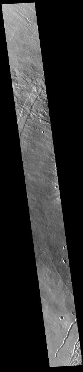
This VIS image shows part of the northwestern flank of Pavonis Mons. Pavonis Mons is the central volcano of the three large Tharsis volcanoes. All three volcanoes form a line located along a tectonic bulge caused by extensional forces in the region. Pavonis Mons is the smallest of the three with a summit of only 14km (46,000 ft). The linear features in the image are concentric faults. Pavonis means peacock in Latin, making the name peacock mountain. Orbit Number: 88202 Latitude: 0.534605 Longitude: 245.963 Instrument: VIS Captured: 2021-11-01 20:33 https://photojournal.jpl.nasa.gov/catalog/PIA25193
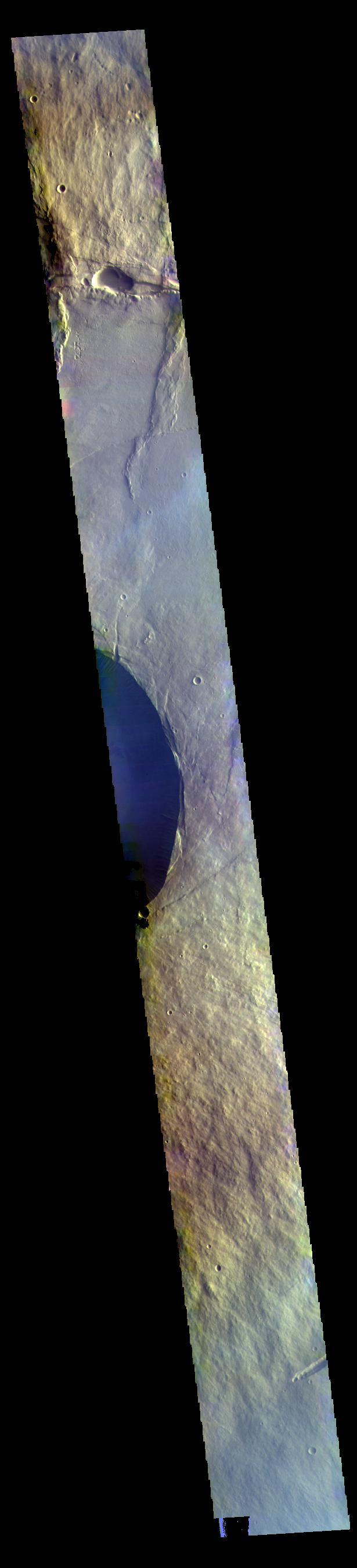
This VIS image shows a cross section of Pavonis Mons, including the central part of the smaller summit caldera (circular depression). On the top side of the caldera is a complex region of fault related collapse of the wall of the caldera. Several intersecting faults are visible there. The faults would have formed areas of weakness in the caldera wall, precipitating into gravity driven down slope movement of materials. This caldera is approximately 5km (3 miles) deep, much deeper that the larger caldera that surrounds the northern and eastern sides of the small caldera. Pavonis Mons, like the other large volcanoes in the region, is a shield volcano. Shield volcanoes are formed by lava flows originating near or at the summit, building up layers upon layers of lava. In shield volcanoes summit calderas are typically formed where the surface collapses into the void formed by an emptied magma chamber. Pavonis Mons is one of the three aligned Tharsis Volcanoes. In order from north to south are Ascreaus Mons, Pavonis Mons and Arsia Mons. The three aligned volcanoes are located along a topographic rise in the Tharsis region. Along this trend there are increased tectonic features and additional lava flows that arose from the flanks of the volcanoes rather than the summit. Pavonis Mons is the smallest of the three volcanoes, rising 14 km (8 miles) above the mean Mars surface level with a width of 375 km (233 miles). Like most shield volcanoes the surface has a low profile. In the case of Pavonis Mons the average slope is only 4 degrees. Orbit Number: 88177 Latitude: 0.900987 Longitude: 247.141 Instrument: VIS Captured: 2021-10-30 19:09 https://photojournal.jpl.nasa.gov/catalog/PIA25157

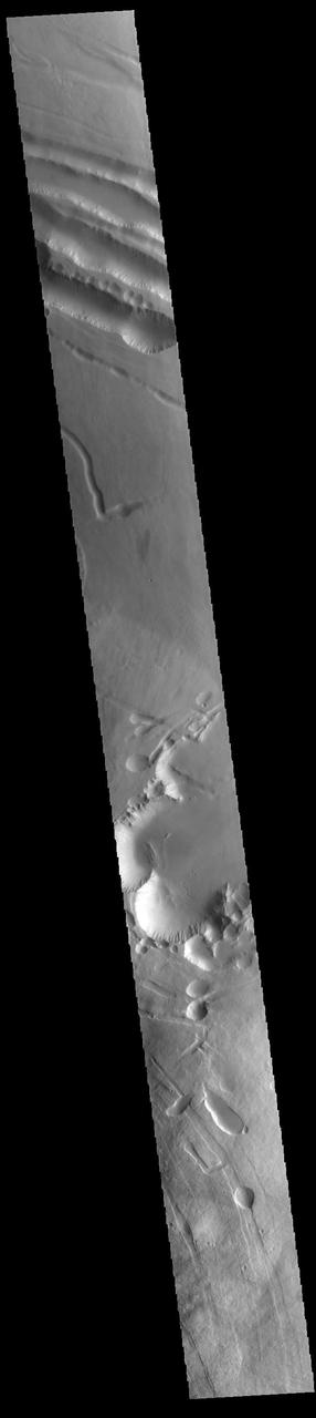
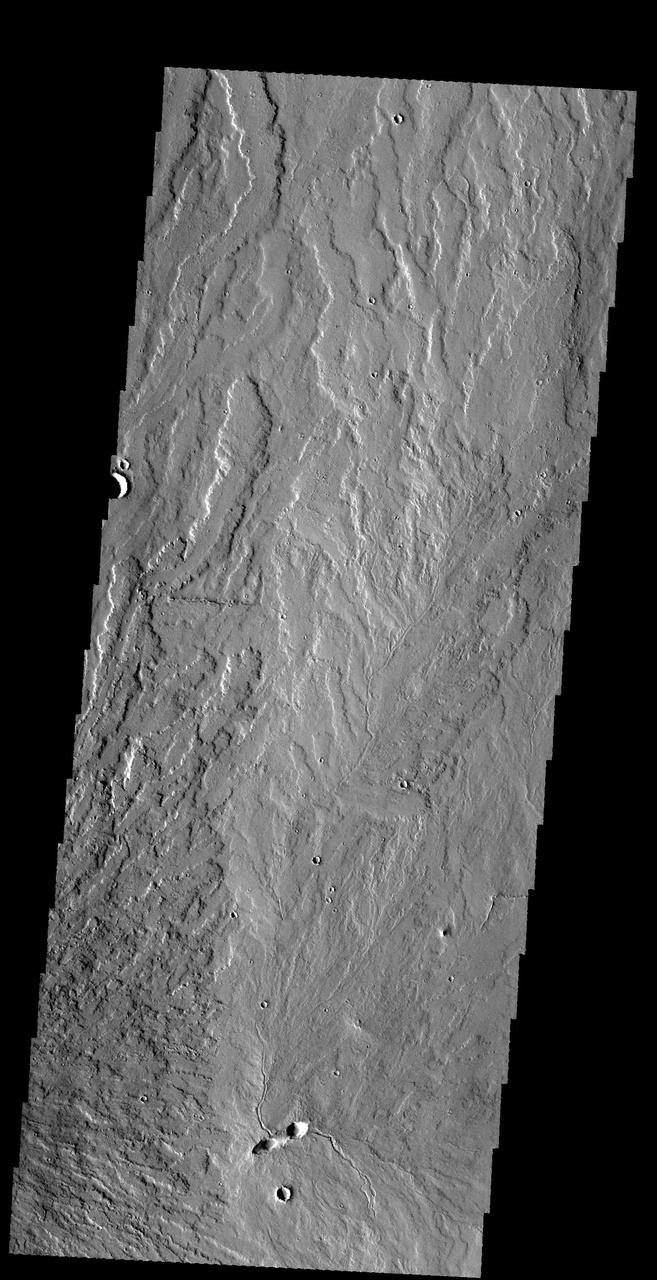
This images shows part of the northeastern flank and margin of Pavonis Mons. Collapse features are common on the the margins of the Tharsis volcanoes along the vent axis
This image captured by NASA 2001 Mars Odyssey spacecraft shows part of the southern flank of Pavonis Mons. Visible at the bottom of the image are collapse features and lava channels.

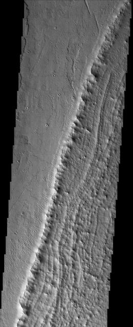
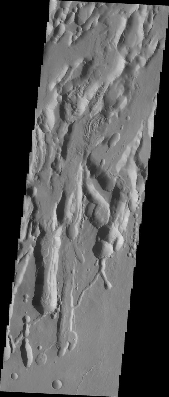
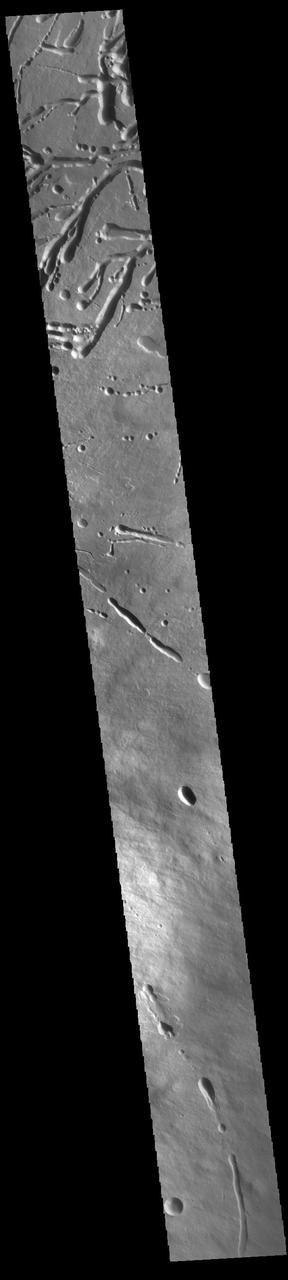
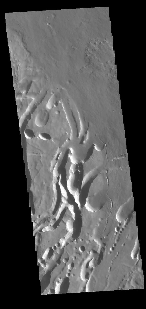
This image shows part of the southern flank of Pavonis Mons. The linear and sinuous features mark the locations of lava tubes and graben that occur on both sides of the volcano along a regional trend that passes thru Pavonis Mons, Ascreaus Mons (to the north), and Arsia Mons (to the south). The majority of the features are believed to be lava tubes where the ceiling has collapsed into the free space below. This often happens starting in a circular pit and then expanding along length of the tube until the entire ceiling of material has collapsed into the bottom of the tube. Pavonis Mons is one of the three aligned Tharsis Volcanoes. The four Tharsis volcanoes are Ascreaus Mons, Pavonis Mons, Arsia Mons, and Olympus Mars. All four are shield type volcanoes. Shield volcanoes are formed by lava flows originating near or at the summit, building up layers upon layers of lava. The Hawaiian islands on Earth are shield volcanoes. The three aligned volcanoes are located along a topographic rise in the Tharsis region. Along this trend there are increased tectonic features and additional lava flows. Pavonis Mons is the smallest of the four volcanoes, rising 14km above the mean Mars surface level with a width of 375km. It has a complex summit caldera, with the smallest caldera deeper than the larger caldera. Like most shield volcanoes the surface has a low profile. In the case of Pavonis Mons the average slope is only 4 degrees. The Odyssey spacecraft has spent over 15 years in orbit around Mars, circling the planet more than 69000 times. It holds the record for longest working spacecraft at Mars. THEMIS, the IR/VIS camera system, has collected data for the entire mission and provides images covering all seasons and lighting conditions. Over the years many features of interest have received repeated imaging, building up a suite of images covering the entire feature. From the deepest chasma to the tallest volcano, individual dunes inside craters and dune fields that encircle the north pole, channels carved by water and lava, and a variety of other feature, THEMIS has imaged them all. For the next several months the image of the day will focus on the Tharsis volcanoes, the various chasmata of Valles Marineris, and the major dunes fields. We hope you enjoy these images! Orbit Number: 7245 Latitude: -0.895004 Longitude: 246.225 Instrument: VIS Captured: 2003-08-02 22:23 https://photojournal.jpl.nasa.gov/catalog/PIA22016

This image shows the southern flank of Pavonis Mons. The large sinuous channel at the bottom of the image is located at the uppermost part of the volcano where collapse features are following the regional linear trend. A lava tube of this size indicates a high volume of lava. Pavonis Mons is one of the three aligned Tharsis Volcanoes. The four Tharsis volcanoes are Ascreaus Mons, Pavonis Mons, Arsia Mons, and Olympus Mars. All four are shield type volcanoes. Shield volcanoes are formed by lava flows originating near or at the summit, building up layers upon layers of lava. The Hawaiian islands on Earth are shield volcanoes. The three aligned volcanoes are located along a topographic rise in the Tharsis region. Along this trend there are increased tectonic features and additional lava flows. Pavonis Mons is the smallest of the four volcanoes, rising 14km above the mean Mars surface level with a width of 375km. It has a complex summit caldera, with the smallest caldera deeper than the larger caldera. Like most shield volcanoes the surface has a low profile. In the case of Pavonis Mons the average slope is only 4 degrees. The Odyssey spacecraft has spent over 15 years in orbit around Mars, circling the planet more than 69000 times. It holds the record for longest working spacecraft at Mars. THEMIS, the IR/VIS camera system, has collected data for the entire mission and provides images covering all seasons and lighting conditions. Over the years many features of interest have received repeated imaging, building up a suite of images covering the entire feature. From the deepest chasma to the tallest volcano, individual dunes inside craters and dune fields that encircle the north pole, channels carved by water and lava, and a variety of other feature, THEMIS has imaged them all. For the next several months the image of the day will focus on the Tharsis volcanoes, the various chasmata of Valles Marineris, and the major dunes fields. We hope you enjoy these images! Orbit Number: 45493 Latitude: -0.197065 Longitude: 246.516 Instrument: VIS Captured: 2012-03-17 03:39 https://photojournal.jpl.nasa.gov/catalog/PIA22025
This VIS image shows a portion of the northern flank of Pavonis Mons. The linear features at the top of the image are concentric faults. The linear and sinuous channel-like features at the bottom of the image likely formed by collapse of the roof of lava tubes into the empty space beneath. Pavonis Mons is the central volcano of the three large Tharsis volcanoes. In order from north to south the volcanoes are Ascreaus Mons, Pavonis Mons and Arsia Mons. All three volcanoes form a line located along a tectonic bulge caused by extensional forces in the region. Along this trend there are increased tectonic features and additional lava flows that arose from the flanks of the volcanoes rather than just the summit. Like the other large volcanoes in the region, Pavonis Mons is a shield volcano. Shield volcanoes are formed by lava flows originating near or at the summit, building up layers upon layers of lava. In shield volcanoes summit calderas are typically formed where the surface collapses into the void formed by an emptied magma chamber. Pavonis Mons is the smallest of the three volcanoes with a summit of only 14km (8.7 miles) and a width of 375 km (233 miles). Like most shield volcanoes the surface has a low profile. In the case of Pavonis Mons the average slope is only 4 degrees. Pavonis means peacock in Latin, making its name peacock mountain. Orbit Number: 93942 Latitude: 3.03864 Longitude: 248.737 Instrument: VIS Captured: 2023-02-17 11:45 https://photojournal.jpl.nasa.gov/catalog/PIA25931
This VIS image shows a cross section of Pavonis Mons, including the central part of the smaller summit caldera (circular depression). On the top side of the caldera is a complex region of fault related collapse of the wall of the caldera. Several intersecting faults are visible there. The faults would have formed areas of weakness in the caldera wall, precipitating into gravity driven down slope movement of materials. This caldera is approximately 5km (3 miles) deep, much deeper that the larger caldera that surrounds the northern and eastern sides of the small caldera. Pavonis Mons, like the other large volcanoes in the region, is a shield volcano. Shield volcanoes are formed by lava flows originating near or at the summit, building up layers upon layers of lava. In shield volcanoes summit calderas are typically formed where the surface collapses into the void formed by an emptied magma chamber. Pavonis Mons is one of the three aligned Tharsis Volcanoes. In order from north to south are Ascreaus Mons, Pavonis Mons and Arsia Mons. The three aligned volcanoes are located along a topographic rise in the Tharsis region. Along this trend there are increased tectonic features and additional lava flows that arose from the flanks of the volcanoes rather than the summit. Pavonis Mons is the smallest of the three volcanoes, rising 14 km (8 miles) above the mean Mars surface level with a width of 375 km (233 miles). Like most shield volcanoes the surface has a low profile. In the case of Pavonis Mons the average slope is only 4 degrees. Orbit Number: 86118 Latitude: 0.356409 Longitude: 247.166 Instrument: VIS Captured: 2021-05-14 06:19 https://photojournal.jpl.nasa.gov/catalog/PIA24223
This image from NASA Mars Odyssey shows part of the summit caldera of Pavonis Mons, the middle of three Tharsis volcanos that form a line southeast of Olympus Mons and northwest of Vallis Marineris.
This image shows part smaller summit caldera of Pavonis Mons. This caldera is approximately 5km deep. Near the bottom of the image is a region where part of the caldera side has collapsed into the bottom of the caldera. In shield volcanoes calderas are typically formed where the surface collapses into the void formed by an emptied magma chamber. Pavonis Mons is one of the three aligned Tharsis Volcanoes. The four Tharsis volcanoes are Ascreaus Mons, Pavonis Mons, Arsia Mons, and Olympus Mars. All four are shield type volcanoes. Shield volcanoes are formed by lava flows originating near or at the summit, building up layers upon layers of lava. The Hawaiian islands on Earth are shield volcanoes. The three aligned volcanoes are located along a topographic rise in the Tharsis region. Along this trend there are increased tectonic features and additional lava flows. Pavonis Mons is the smallest of the four volcanoes, rising 14km above the mean Mars surface level with a width of 375km. It has a complex summit caldera, with the smallest caldera deeper than the larger caldera. Like most shield volcanoes the surface has a low profile. In the case of Pavonis Mons the average slope is only 4 degrees. The Odyssey spacecraft has spent over 15 years in orbit around Mars, circling the planet more than 69000 times. It holds the record for longest working spacecraft at Mars. THEMIS, the IR/VIS camera system, has collected data for the entire mission and provides images covering all seasons and lighting conditions. Over the years many features of interest have received repeated imaging, building up a suite of images covering the entire feature. From the deepest chasma to the tallest volcano, individual dunes inside craters and dune fields that encircle the north pole, channels carved by water and lava, and a variety of other feature, THEMIS has imaged them all. For the next several months the image of the day will focus on the Tharsis volcanoes, the various chasmata of Valles Marineris, and the major dunes fields. We hope you enjoy these images! Orbit Number: 32776 Latitude: 0.446561 Longitude: 247.283 Instrument: VIS Captured: 2009-05-05 03:21 https://photojournal.jpl.nasa.gov/catalog/PIA22023
This image from NASA Mars Odyssey shows Pavonis Mons, one of the three huge Tharsis volcanoes, encircled on the west side by a series of arcuate ridges. How these features were formed is still unknown.
At the top right of this NASA Mars Odyssey image, the rim of the caldera of Pavonis Mons, one of four exceptionally large volcanoes in the Tharsis region, is barely visible with steep cliffs formed by the collapse of a portion of the volcano summit.
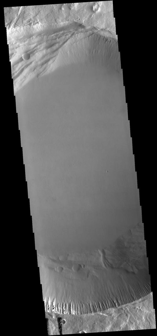
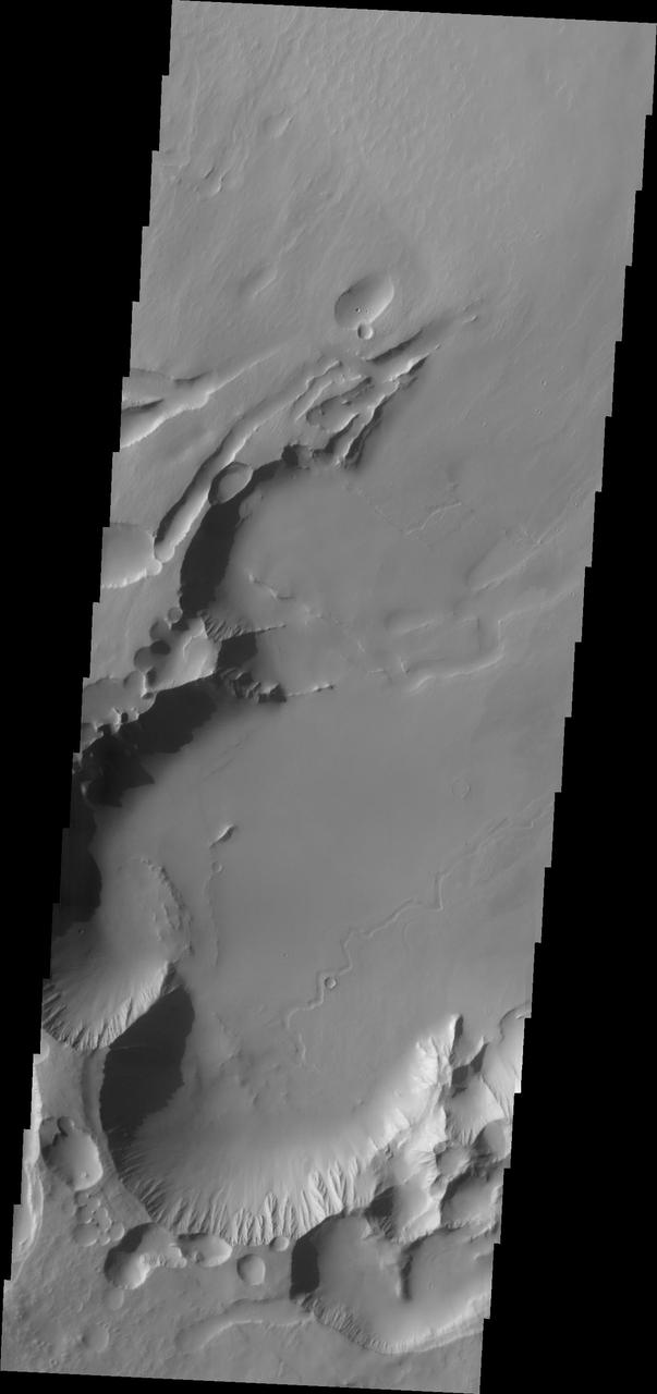
This image shows part of the two summit calderas of Pavonis Mons. The surface in the majority of the image is the floor of the larger caldera. The smaller caldera occupies the bottom of the image. In both calderas the floor is predominately flat. The final summit flow would have pooled in the caldera and cooled forming the flat floor. Pavonis Mons is one of the three aligned Tharsis Volcanoes. The four Tharsis volcanoes are Ascreaus Mons, Pavonis Mons, Arsia Mons, and Olympus Mars. All four are shield type volcanoes. Shield volcanoes are formed by lava flows originating near or at the summit, building up layers upon layers of lava. The Hawaiian islands on Earth are shield volcanoes. The three aligned volcanoes are located along a topographic rise in the Tharsis region. Along this trend there are increased tectonic features and additional lava flows. Pavonis Mons is the smallest of the four volcanoes, rising 14km above the mean Mars surface level with a width of 375km. It has a complex summit caldera, with the smallest caldera deeper than the larger caldera. Like most shield volcanoes the surface has a low profile. In the case of Pavonis Mons the average slope is only 4 degrees. The Odyssey spacecraft has spent over 15 years in orbit around Mars, circling the planet more than 69000 times. It holds the record for longest working spacecraft at Mars. THEMIS, the IR/VIS camera system, has collected data for the entire mission and provides images covering all seasons and lighting conditions. Over the years many features of interest have received repeated imaging, building up a suite of images covering the entire feature. From the deepest chasma to the tallest volcano, individual dunes inside craters and dune fields that encircle the north pole, channels carved by water and lava, and a variety of other feature, THEMIS has imaged them all. For the next several months the image of the day will focus on the Tharsis volcanoes, the various chasmata of Valles Marineris, and the major dunes fields. We hope you enjoy these images! Orbit Number: 17590 Latitude: 1.13446 Longitude: 247.411 Instrument: VIS Captured: 2005-12-01 17:26 https://photojournal.jpl.nasa.gov/catalog/PIA22020
This image shows the western part of the smaller summit caldera on Pavonis Mons. On this side of the caldera is a complex region of fault related collapse of the wall of the caldera. Several intersecting faults are visible to the top and center part of the image. The faults would have formed areas of weakness in the caldera wall, precipitating into gravity driven down slope movement of materials. This caldera is approximately 5km deep. In shield volcanoes calderas are typically formed where the surface collapses into the void formed by an emptied magma chamber. Pavonis Mons is one of the three aligned Tharsis Volcanoes. The four Tharsis volcanoes are Ascreaus Mons, Pavonis Mons, Arsia Mons, and Olympus Mars. All four are shield type volcanoes. Shield volcanoes are formed by lava flows originating near or at the summit, building up layers upon layers of lava. The Hawaiian islands on Earth are shield volcanoes. The three aligned volcanoes are located along a topographic rise in the Tharsis region. Along this trend there are increased tectonic features and additional lava flows. Pavonis Mons is the smallest of the four volcanoes, rising 14km above the mean Mars surface level with a width of 375km. It has a complex summit caldera, with the smallest caldera deeper than the larger caldera. Like most shield volcanoes the surface has a low profile. In the case of Pavonis Mons the average slope is only 4 degrees. The Odyssey spacecraft has spent over 15 years in orbit around Mars, circling the planet more than 69000 times. It holds the record for longest working spacecraft at Mars. THEMIS, the IR/VIS camera system, has collected data for the entire mission and provides images covering all seasons and lighting conditions. Over the years many features of interest have received repeated imaging, building up a suite of images covering the entire feature. From the deepest chasma to the tallest volcano, individual dunes inside craters and dune fields that encircle the north pole, channels carved by water and lava, and a variety of other feature, THEMIS has imaged them all. For the next several months the image of the day will focus on the Tharsis volcanoes, the various chasmata of Valles Marineris, and the major dunes fields. We hope you enjoy these images! Orbit Number: 36607 Latitude: 0.609285 Longitude: 246.862 Instrument: VIS Captured: 2010-03-16 13:44 https://photojournal.jpl.nasa.gov/catalog/PIA22024
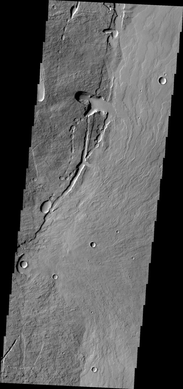
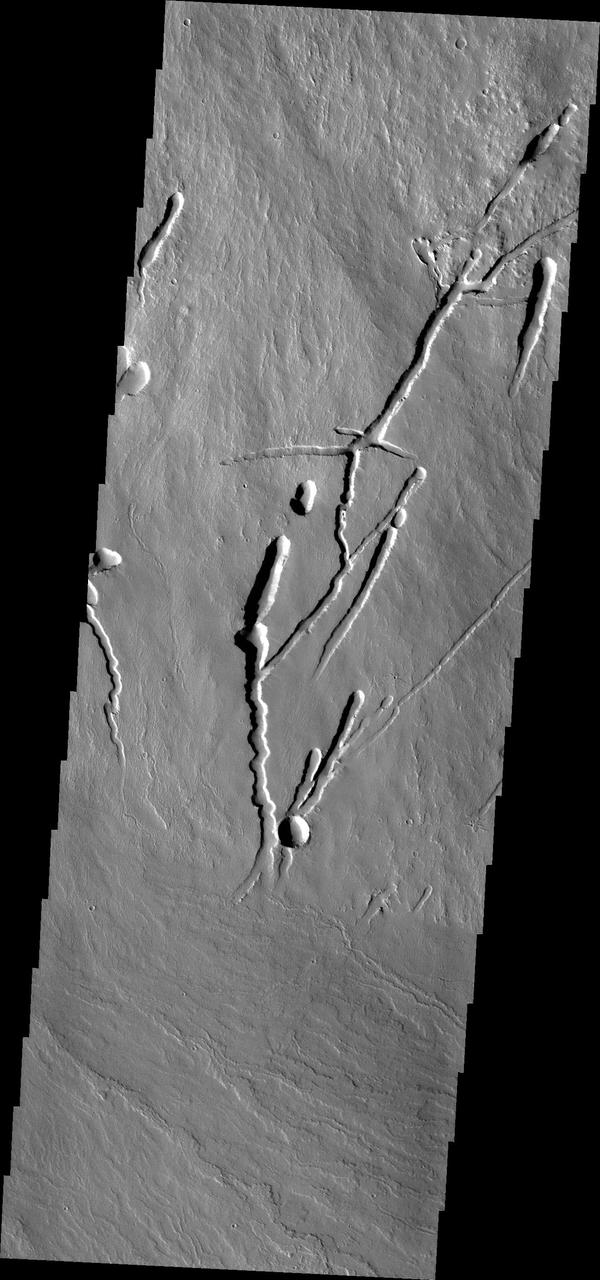
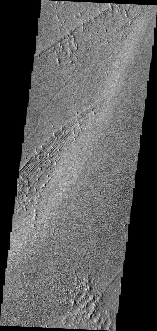
his image shows part of the eastern flank of Pavonis Mons. Surface lava flows run down hill from the upper left of the image towards the bottom right. Perpendicular to that trend are several linear features. These are faults that encircle the volcano and also run along the linear trend through the three Tharsis volcanoes. This image shows a collapsed lava tube where a flow followed the trend of a graben and then "turned" to flow down hill. Graben are linear features, so lava flows in them are linear. Where the lava flow is running along the surface of the volcano it has sinuosity just like a river. The mode of formation of a lava tube starts with a surface lava flow. The sides and top of the flow cool faster than the center, eventually forming a solid, non-flowing cover of the still flowing lava. The surface flow may have followed the deeper fault block graben (a lower surface than the surroundings). Once the flow stops there remains the empty space lower than the surroundings, and collapse of the top of the tube starts in small pits which coalesce in the linear features. Pavonis Mons is one of the three aligned Tharsis Volcanoes. The four Tharsis volcanoes are Ascreaus Mons, Pavonis Mons, Arsia Mons, and Olympus Mars. All four are shield type volcanoes. Shield volcanoes are formed by lava flows originating near or at the summit, building up layers upon layers of lava. The Hawaiian islands on Earth are shield volcanoes. The three aligned volcanoes are located along a topographic rise in the Tharsis region. Along this trend there are increased tectonic features and additional lava flows. Pavonis Mons is the smallest of the four volcanoes, rising 14km above the mean Mars surface level with a width of 375km. It has a complex summit caldera, with the smallest caldera deeper than the larger caldera. Like most shield volcanoes the surface has a low profile. In the case of Pavonis Mons the average slope is only 4 degrees. The Odyssey spacecraft has spent over 15 years in orbit around Mars, circling the planet more than 69000 times. It holds the record for longest working spacecraft at Mars. THEMIS, the IR/VIS camera system, has collected data for the entire mission and provides images covering all seasons and lighting conditions. Over the years many features of interest have received repeated imaging, building up a suite of images covering the entire feature. From the deepest chasma to the tallest volcano, individual dunes inside craters and dune fields that encircle the north pole, channels carved by water and lava, and a variety of other feature, THEMIS has imaged them all. For the next several months the image of the day will focus on the Tharsis volcanoes, the various chasmata of Valles Marineris, and the major dunes fields. We hope you enjoy these images! Orbit Number: 32751 Latitude: 0.338236 Longitude: 248.74 Instrument: VIS Captured: 2009-05-03 01:57 https://photojournal.jpl.nasa.gov/catalog/PIA22022
This image shows a portion of the flank of Pavonis Mons as seen by NASA 2001 Mars Odyssey spacecraft. The collapse features at the bottom of the image are related to subsurface tubes that once contained lava.
Pavonis Mons is the middle of the three large volcanoes on the Tharsis bulge. This image from NASA Mars Odyssey spacecraft covers the edge of the volcano caldera. Outside of the caldera, numerous lava flows and impact craters can be seen.
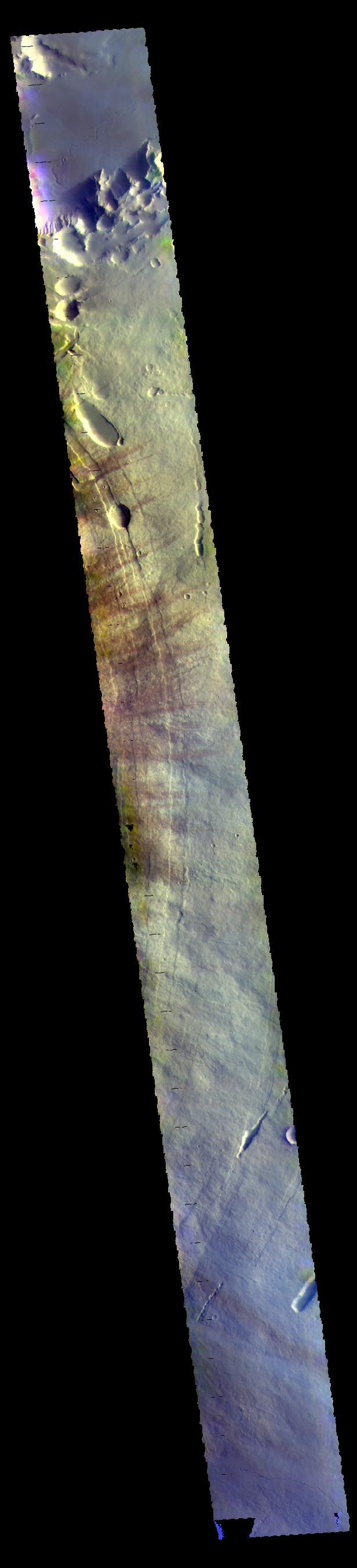
Today's VIS image crosses the flanks and summit of Pavonis Mons. The THEMIS VIS camera contains 5 filters. The data from different filters can be combined in multiple ways to create a false color image. These false color images may reveal subtle variations of the surface not easily identified in a single band image. Orbit Number: 60818 Latitude: 0.573053 Longitude: 247.537 Instrument: VIS Captured: 2015-08-30 12:10 https://photojournal.jpl.nasa.gov/catalog/PIA22720
This VIS image shows the eastern flank of Pavonis Mons. The darker streaks are created by wind action. The THEMIS VIS camera contains 5 filters. The data from different filters can be combined in multiple ways to create a false color image. These false color images may reveal subtle variations of the surface not easily identified in a single band image. Orbit Number: 61080 Latitude: 1.34334 Longitude: 249.058 Instrument: VIS Captured: 2015-09-21 01:59 https://photojournal.jpl.nasa.gov/catalog/PIA22779
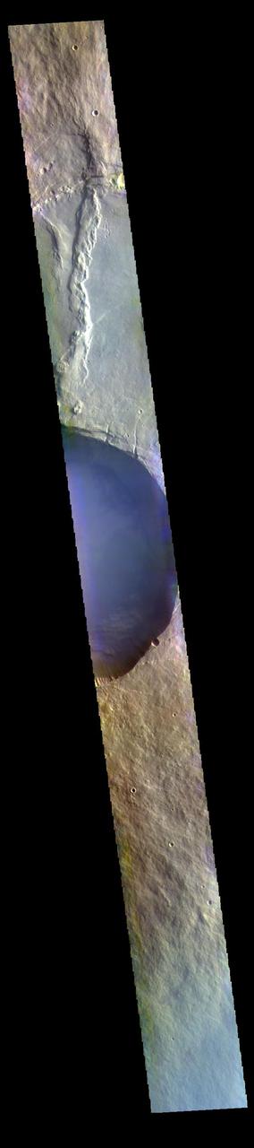
The THEMIS VIS camera contains 5 filters. The data from different filters can be combined in multiple ways to create a false color image. These false color images may reveal subtle variations of the surface not easily identified in a single band image. Today's false color image shows a cross section of Pavonis Mons, including part of the summit caldera (circular depression). This caldera is approximately 5km (3 miles) deep, much deeper that the larger caldera that surrounds the northern and eastern sides of the small caldera. Pavonis Mons, like the other large volcanoes in the region, is a shield volcano. Shield volcanoes are formed by lava flows originating near or at the summit, building up layers upon layers of lava. In shield volcanoes summit calderas are typically formed where the surface collapses into the void formed by an emptied magma chamber. Pavonis Mons is one of the three aligned Tharsis Volcanoes. In order from north to south are Ascreaus Mons, Pavonis Mons and Arsia Mons. The three aligned volcanoes are located along a topographic rise in the Tharsis region. Along this trend there are increased tectonic features and additional lava flows that arose from the flanks of the volcanoes rather than the summit. Pavonis Mons is the smallest of the three volcanoes, rising 14 km (8 miles) above the mean Mars surface level with a width of 375 km (233 miles). Like most shield volcanoes the surface has a low profile. In the case of Pavonis Mons the average slope is only 4 degrees. The THEMIS VIS camera is capable of capturing color images of the Martian surface using five different color filters. In this mode of operation, the spatial resolution and coverage of the image must be reduced to accommodate the additional data volume produced from using multiple filters. To make a color image, three of the five filter images (each in grayscale) are selected. Each is contrast enhanced and then converted to a red, green, or blue intensity image. These three images are then combined to produce a full color, single image. Because the THEMIS color filters don't span the full range of colors seen by the human eye, a color THEMIS image does not represent true color. Also, because each single-filter image is contrast enhanced before inclusion in the three-color image, the apparent color variation of the scene is exaggerated. Nevertheless, the color variation that does appear is representative of some change in color, however subtle, in the actual scene. Note that the long edges of THEMIS color images typically contain color artifacts that do not represent surface variation. Orbit Number: 94566 Latitude: 0.498282 Longitude: 247.385 Instrument: VIS Captured: 2023-04-09 20:50 https://photojournal.jpl.nasa.gov/catalog/PIA26130
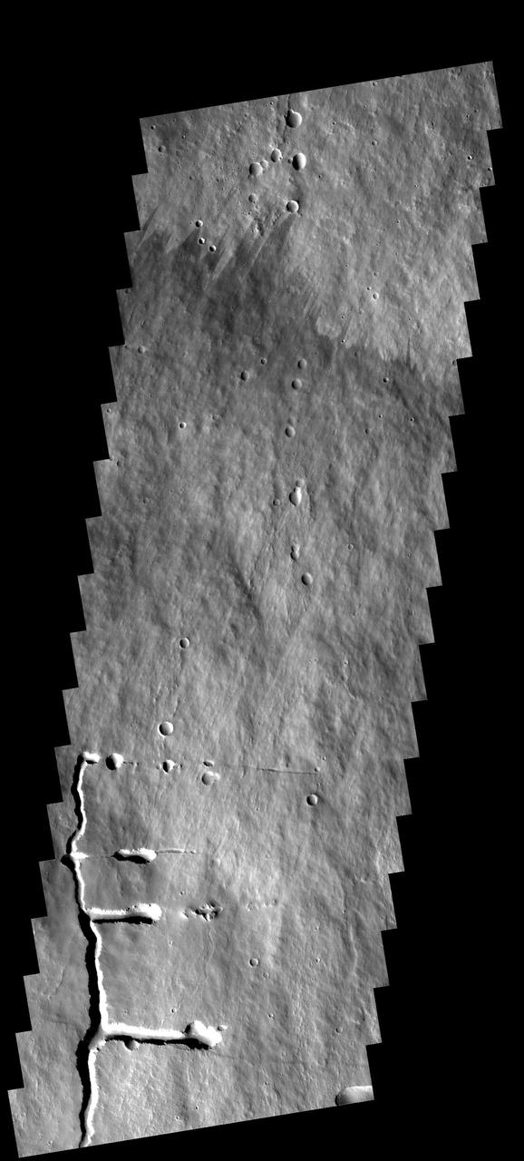
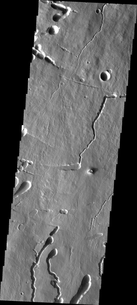
This VIS image shows part of the area where Pavonis Chasma intersects with Pavonis Fossae. It is a region of lava flows from Pavonis Mons and depressions likely formed by collapse into lava tubes and tectonic graben. Orbit Number: 65596 Latitude: 3.32631 Longitude: 249.947 Instrument: VIS Captured: 2016-09-27 00:55 http://photojournal.jpl.nasa.gov/catalog/PIA21160

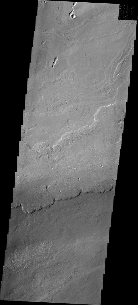
This image shows part of the western flank of Pavonis Mons. The linear features are faults. Faulting usually includes change of elevation, where blocks of material slide down the fault. Paired faults are call graben. The large depression is a graben, whereas most of the other faults are not paired. The rougher looking materials perpendicular to the faults are lava flows. "Down hill" is to the upper left corner of the image. Pavonis Mons is one of the three aligned Tharsis Volcanoes. The four Tharsis volcanoes are Ascreaus Mons, Pavonis Mons, Arsia Mons, and Olympus Mars. All four are shield type volcanoes. Shield volcanoes are formed by lava flows originating near or at the summit, building up layers upon layers of lava. The Hawaiian islands on Earth are shield volcanoes. The three aligned volcanoes are located along a topographic rise in the Tharsis region. Along this trend there are increased tectonic features and additional lava flows. Pavonis Mons is the smallest of the four volcanoes, rising 14km above the mean Mars surface level with a width of 375km. It has a complex summit caldera, with the smallest caldera deeper than the larger caldera. Like most shield volcanoes the surface has a low profile. In the case of Pavonis Mons the average slope is only 4 degrees. The Odyssey spacecraft has spent over 15 years in orbit around Mars, circling the planet more than 69000 times. It holds the record for longest working spacecraft at Mars. THEMIS, the IR/VIS camera system, has collected data for the entire mission and provides images covering all seasons and lighting conditions. Over the years many features of interest have received repeated imaging, building up a suite of images covering the entire feature. From the deepest chasma to the tallest volcano, individual dunes inside craters and dune fields that encircle the north pole, channels carved by water and lava, and a variety of other feature, THEMIS has imaged them all. For the next several months the image of the day will focus on the Tharsis volcanoes, the various chasmata of Valles Marineris, and the major dunes fields. We hope you enjoy these images! Orbit Number: 14857 Latitude: 1.4859 Longitude: 245.996 Instrument: VIS Captured: 2005-04-20 17:00 https://photojournal.jpl.nasa.gov/catalog/PIA22017
This image shows part of the southern flank of Pavonis Mons. Several faults run from the left to the right side of the image. Lava flows, and the lava collapse features at the bottom of the image are aligned with the down hill direction (in this case from the top of the image to the bottom). Near the top of the image there are collapse features that run along the faults. The fault may have been been a location for lava tube development. Pavonis Mons is one of the three aligned Tharsis Volcanoes. The four Tharsis volcanoes are Ascreaus Mons, Pavonis Mons, Arsia Mons, and Olympus Mars. All four are shield type volcanoes. Shield volcanoes are formed by lava flows originating near or at the summit, building up layers upon layers of lava. The Hawaiian islands on Earth are shield volcanoes. The three aligned volcanoes are located along a topographic rise in the Tharsis region. Along this trend there are increased tectonic features and additional lava flows. Pavonis Mons is the smallest of the four volcanoes, rising 14km above the mean Mars surface level with a width of 375km. It has a complex summit caldera, with the smallest caldera deeper than the larger caldera. Like most shield volcanoes the surface has a low profile. In the case of Pavonis Mons the average slope is only 4 degrees. The Odyssey spacecraft has spent over 15 years in orbit around Mars, circling the planet more than 69000 times. It holds the record for longest working spacecraft at Mars. THEMIS, the IR/VIS camera system, has collected data for the entire mission and provides images covering all seasons and lighting conditions. Over the years many features of interest have received repeated imaging, building up a suite of images covering the entire feature. From the deepest chasma to the tallest volcano, individual dunes inside craters and dune fields that encircle the north pole, channels carved by water and lava, and a variety of other feature, THEMIS has imaged them all. For the next several months the image of the day will focus on the Tharsis volcanoes, the various chasmata of Valles Marineris, and the major dunes fields. We hope you enjoy these images! Orbit Number: 15457 Latitude: -1.03884 Longitude: 246.532 Instrument: VIS Captured: 2005-06-09 00:38 https://photojournal.jpl.nasa.gov/catalog/PIA22018
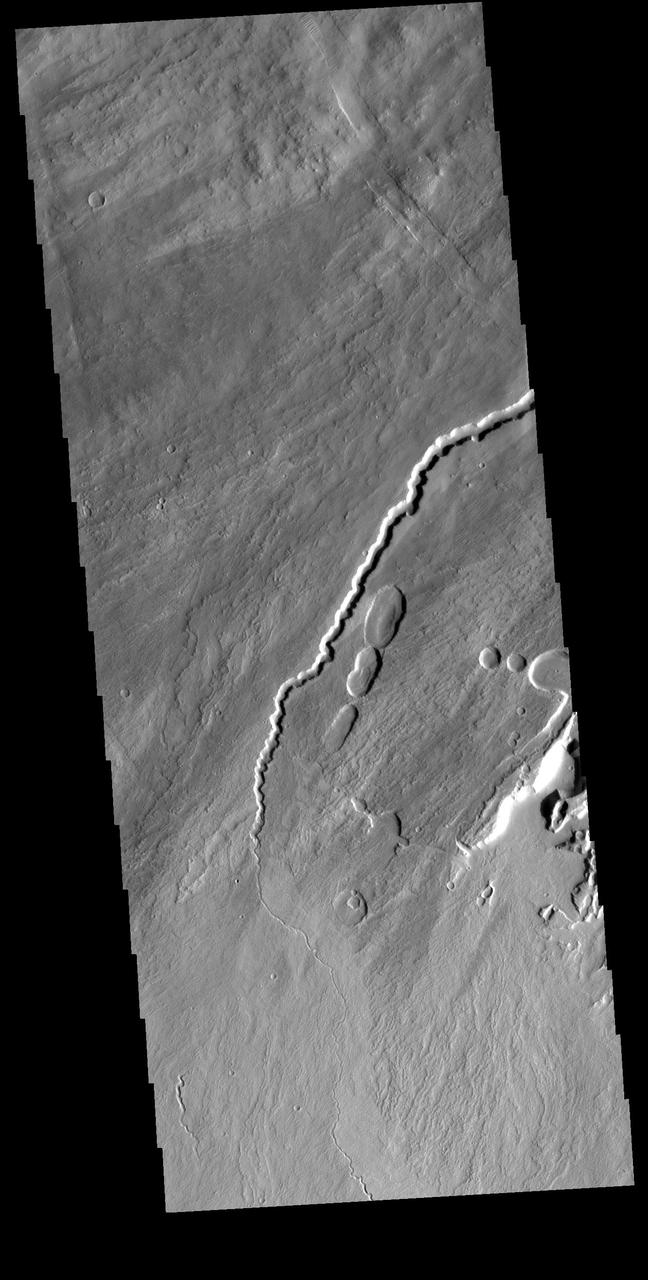
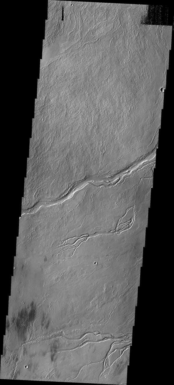
Today's VIS image is of the eastern flank of Pavonis Mons where the volcano meets the surrounding volcanic plains. The arced features toward the top of the image are fractures and lava tubes that were revealed by collapse of the roof of the tube into the underlying void. Orbit Number: 72343 Latitude: 0.300092 Longitude: 249.729 Instrument: VIS Captured: 2018-04-05 21:52 https://photojournal.jpl.nasa.gov/catalog/PIA22580
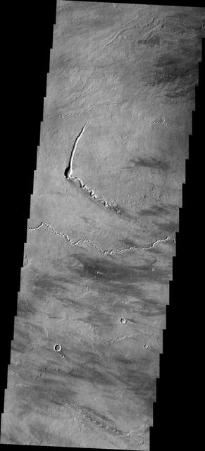
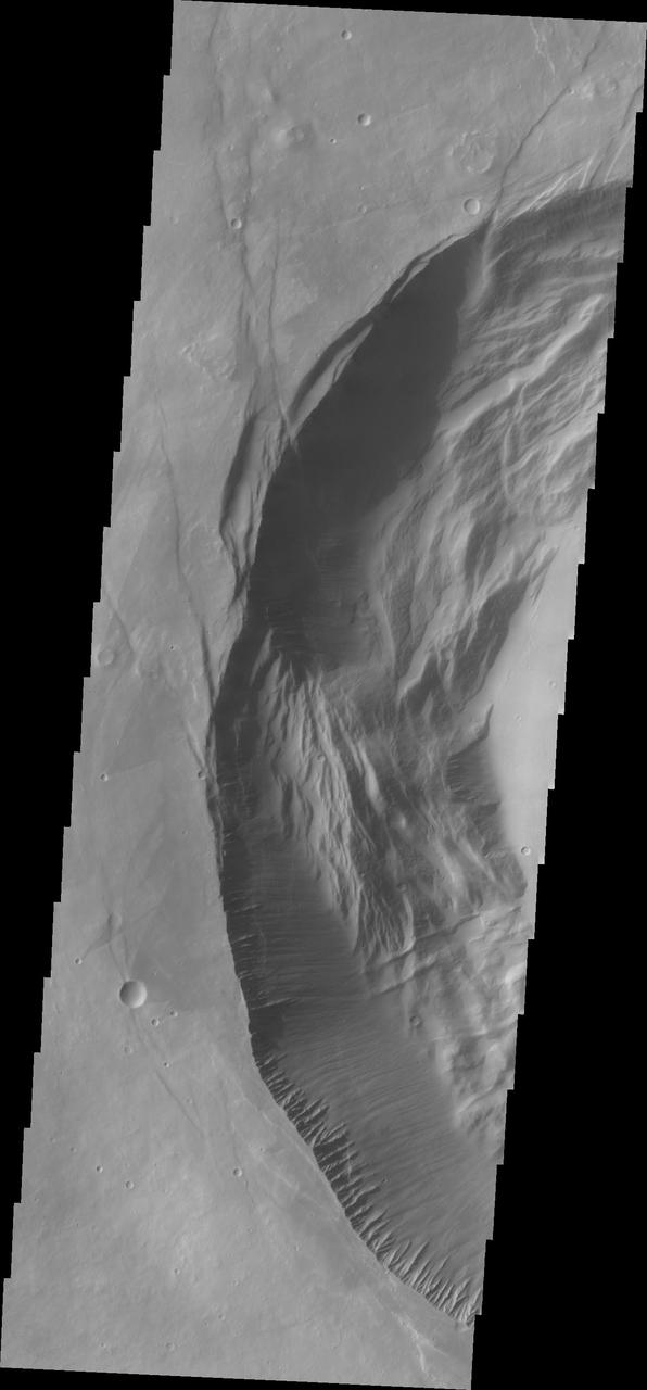
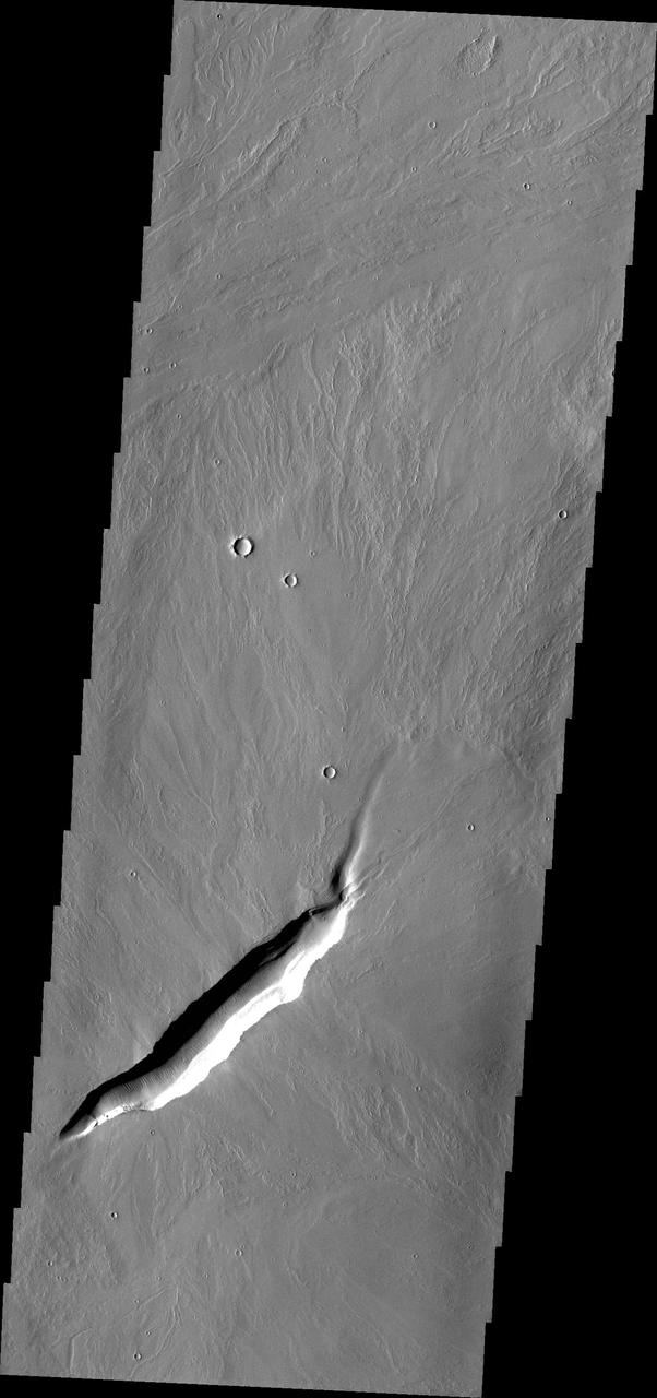
This VIS image shows part of the southwestern flank of Pavonis Mons. The channel and nearby oval depressions are both related to the flow of lava. Narrow lava flows can create channels. The cooling of the top of the channel will form a roof over the flow, creating a tube beneath the surface. After the lava stops flowing the tube can empty, leaving a subsurface void. The roof will then collapse into the void forming the oval surface features. Orbit Number: 73104 Latitude: -1.15359 Longitude: 245.948 Instrument: VIS Captured: 2018-06-07 14:23 https://photojournal.jpl.nasa.gov/catalog/PIA22666
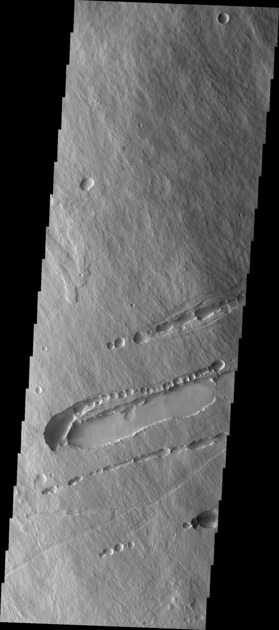
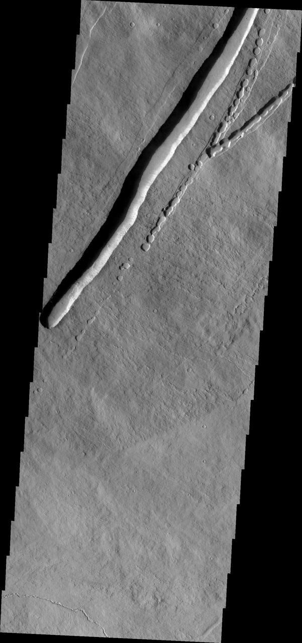
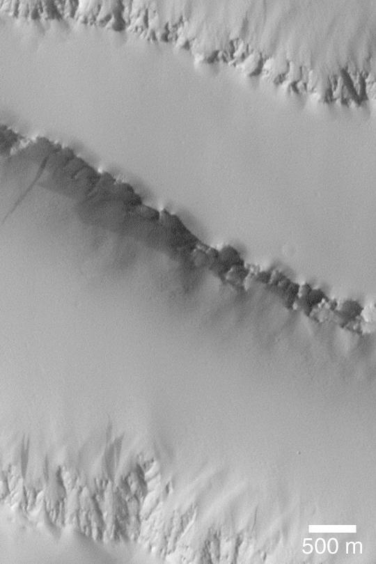
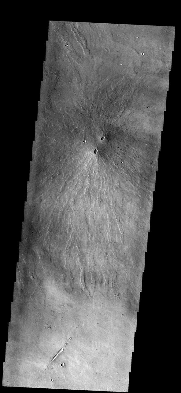
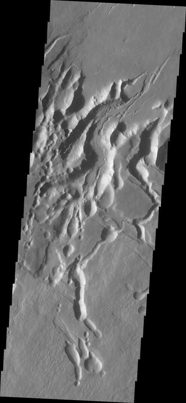
This image shows part of the southeastern flank of Pavonis Mons. Surface lava flows run down hill from the top left of the image to the bottom right. Perpendicular to that trend are several linear features. These are faults that encircle the volcano and also run along the linear trend through the three Tharsis volcanoes. This image illustrates how subsurface lava tubes collapse into the free space of the empty tube. Just to the top of the deepest depression are a series of circular pits. The pits coalesce into a linear feature near the left side of the deepest depression. The mode of formation of a lava tube starts with a surface lava flow. The sides and top of the flow cool faster than the center, eventually forming a solid, non-flowing cover of the still flowing lava. The surface flow may have followed the deeper fault block graben (a lower surface than the surroundings). Once the flow stops there remains the empty space lower than the surroundings, and collapse of the top of the tube starts in small pits which coalesce in the linear features. Pavonis Mons is one of the three aligned Tharsis Volcanoes. The four Tharsis volcanoes are Ascreaus Mons, Pavonis Mons, Arsia Mons, and Olympus Mars. All four are shield type volcanoes. Shield volcanoes are formed by lava flows originating near or at the summit, building up layers upon layers of lava. The Hawaiian islands on Earth are shield volcanoes. The three aligned volcanoes are located along a topographic rise in the Tharsis region. Along this trend there are increased tectonic features and additional lava flows. Pavonis Mons is the smallest of the four volcanoes, rising 14km above the mean Mars surface level with a width of 375km. It has a complex summit caldera, with the smallest caldera deeper than the larger caldera. Like most shield volcanoes the surface has a low profile. In the case of Pavonis Mons the average slope is only 4 degrees. The Odyssey spacecraft has spent over 15 years in orbit around Mars, circling the planet more than 69000 times. It holds the record for longest working spacecraft at Mars. THEMIS, the IR/VIS camera system, has collected data for the entire mission and provides images covering all seasons and lighting conditions. Over the years many features of interest have received repeated imaging, building up a suite of images covering the entire feature. From the deepest chasma to the tallest volcano, individual dunes inside craters and dune fields that encircle the north pole, channels carved by water and lava, and a variety of other feature, THEMIS has imaged them all. For the next several months the image of the day will focus on the Tharsis volcanoes, the various chasmata of Valles Marineris, and the major dunes fields. We hope you enjoy these images! Orbit Number: 31330 Latitude: -1.26587 Longitude: 247.705 Instrument: VIS Captured: 2009-01-05 23:32 https://photojournal.jpl.nasa.gov/catalog/PIA22021
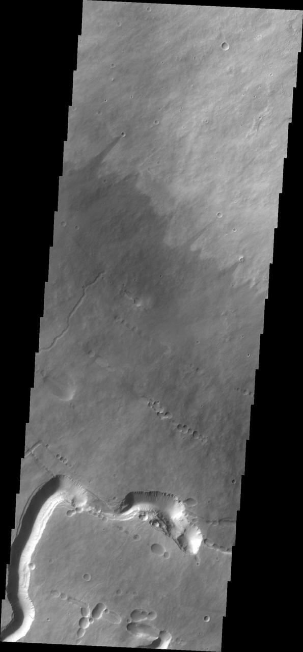
This image from NASA 2001 Mars Odyssey spacecraft shows Pavonis Chasma, a collapsed region on the northeastern flank of Pavonis Mons. The chasma is aligned with the trend of the three Tharsis volcanoes, of which Pavonis Mons is the central one.
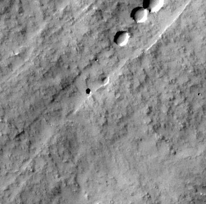
The small crater observed at the middle-right edge of this NASA Mars Odyssey image is very different from other similar looking impact craters located southeast of the Pavonis Mons volcano. This crater appears to be a volcanic crater at the summit of a small composite cone that shows evidence of repeated volcanic flows. http://photojournal.jpl.nasa.gov/catalog/PIA04004

This image from NASA Mars Odyssey spacecraft shows the beginning of Pavonis Chasma top of frame on the northern flank of Pavonis Mons.
The volcanic flows in image from NASA 2001 Mars Odyssey spacecraft are located south of Ascraeus Mons and east of Pavonis Mons.
Today's VIS image shows lava flows near the flank of Pavonis Mons. Pavonis Mons is one of the three large aligned Tharsis region volcanoes. Orbit Number: 77907 Latitude: -1.36831 Longitude: 249.245 Instrument: VIS Captured: 2019-07-08 04:08 https://photojournal.jpl.nasa.gov/catalog/PIA23396

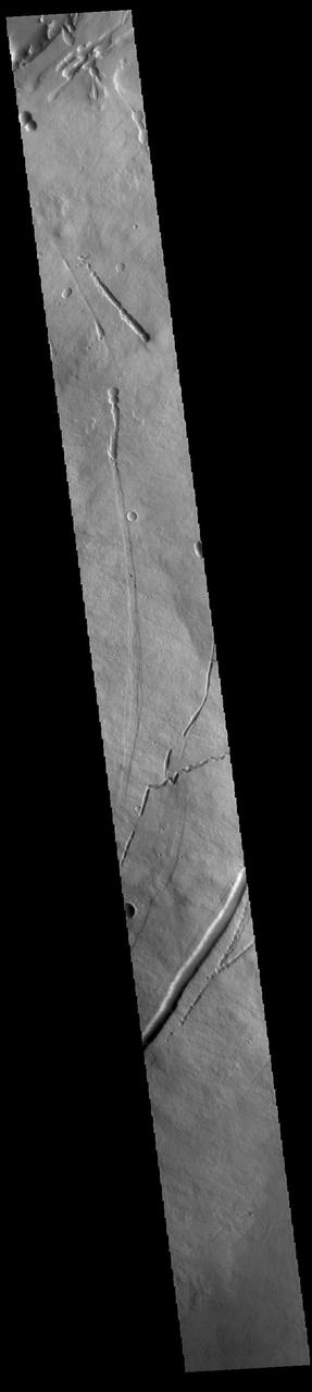
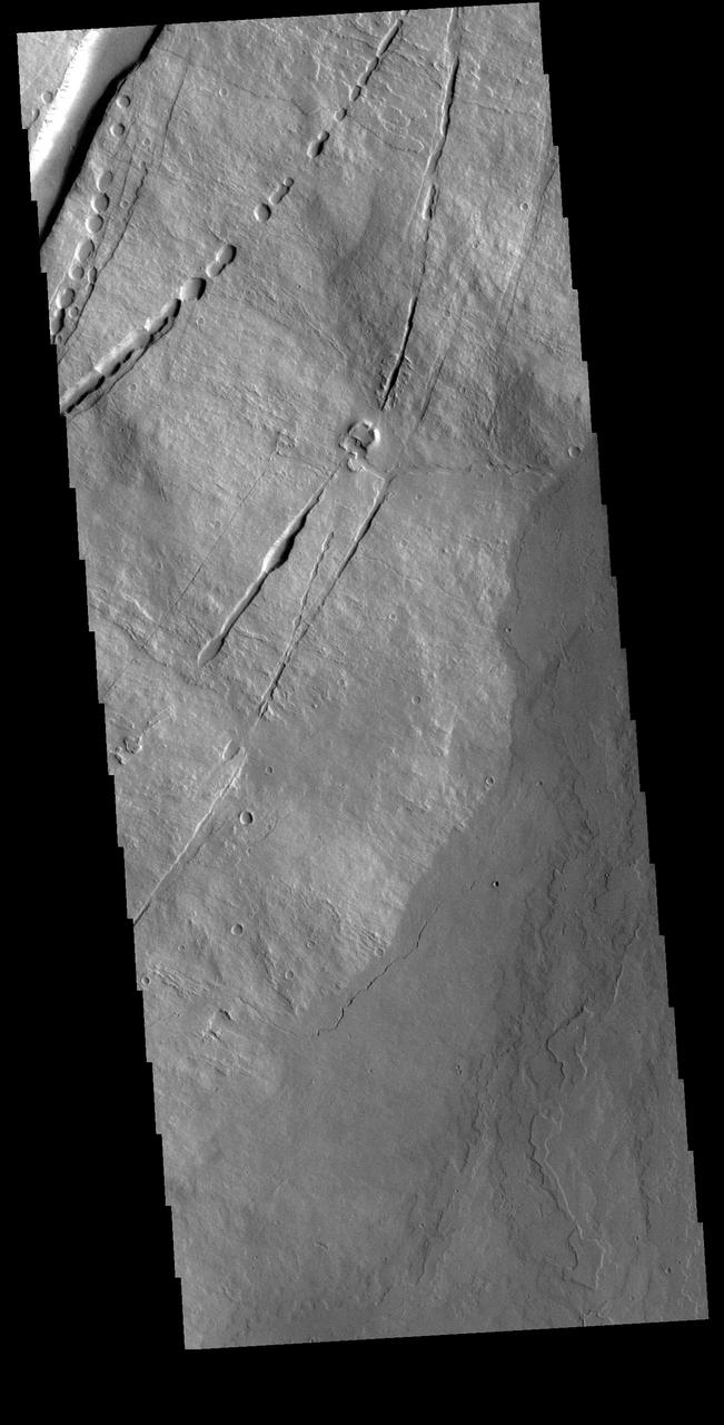
The two depression crossing this image are called Pavonis Fossae and are located on the northern lower flank of Pavonis Mons. These linear features are most likely created by a combination of both tectonic and volcanic forces. The top feature has several narrow 'walls' within the depression, indicating a collapse of the roof of an empty lava tube. Pavonis Mons is the central volcano of the three large Tharsis volcanoes. All three volcanoes form a line located along a tectonic bulge caused by extensional forces in the region. Pavonis Mons is the smallest of the three with a summit of only 14km (8.7 miles). Orbit Number: 90136 Latitude: 3.50046 Longitude: 249.786 Instrument: VIS Captured: 2022-04-10 02:31 https://photojournal.jpl.nasa.gov/catalog/PIA25472
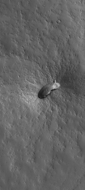
This MOC image shows a small, dust-mantled volcano on the plains east of the giant martian volcano, Pavonis Mons
The linear depression in this image from NASA 2001 Mars Odyssey spacecraft is a volcanic vent in the lava plains east of Pavonis Mons.

The windstreaks in this image captured by NASA 2001 Mars Odyssey spacecraft are located on Tharsis volcanic flows east of Pavonis Mons.
Two volcanic vents have erupted material to form this small volcano just south of Pavonis Mons

The windstreaks in this image from NASA 2001 Mars Odyssey spacecraft are located on the lava plains between Pavonis Mons and Noctis Fossae.
Arsia Chasmata is a complex collapsed region at the northeastern flank of Arsia Mons. The collapsed region aligns with the Pavonis and Ascraeus Mons volcanoes, indicating that all three volcanoes are located on a major fracture in the Tharsis region.
Pavonis Mons is a giant shield volcano similar to although larger than those on the Big Island of Hawaii. This image is from NASA Mars Reconnaissance Orbiter.
Hummocky, textured terrain within lava flows northwest of Pavonis Mons, one of the Tharsis volcanoes, is shown in this image from NASA Mars Odyssey spacecraft.
The channels in this image captured by NASA Mars Odyssey spacecraft were created by the flow of lava. This image shows part of the region between Pavonis and Ascraeus Mons.
Today's VIS image shows volcanic flows and fractures between Arsia Mons and Pavonis Mons in the Tharsis volcanic region. The fractures – termed graben – follow the northeast/southwest trend of the three large Tharsis volcanoes. Orbit Number: 89113 Latitude: -7.38183 Longitude: 244.754 Instrument: VIS Captured: 2022-01-15 20:50 https://photojournal.jpl.nasa.gov/catalog/PIA25348
This image captured by NASA 2001 Mars Odyssey spacecraft shows lava flows near the eastern flank of Pavonis Mons. Orbit Number: 59114 Latitude: 1.42017 Longitude: 250.297 Instrument: VIS Captured: 2015-04-12 05:34 http://photojournal.jpl.nasa.gov/catalog/PIA19480
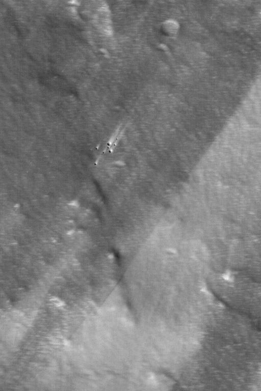
This image captured by NASA Mars Odyssey orbiter shows a Martian pit feature on the slope of an equatorial volcano named Pavonis Mons, appears to be a skylight in an underground lava tube.
The three large aligned Tharsis volcanoes are Arsia Mons, Pavonis Mons and Ascreaus Mons (from south to north). There are collapse features on all three volcanoes, on the southwestern and northeastern flanks. This alignment may indicate a large fracture/vent system was responsible for the eruptions that formed all three volcanoes. This VIS image shows cross section from the summit caldera to the plains near the southern flank of Arsia Mons. Arsia Mons is 270 miles (450km) in diameter, almost 12 miles (20km) high, and the summit caldera is 72 miles (120km) wide. For comparison, the largest volcano on Earth is Mauna Loa. From its base on the sea floor, Mauna Loa measures only 6.3 (10km) miles high and 75 miles (120km) in diameter. A large volcanic crater known as a caldera is located at the summit of all of the Tharsis volcanoes. These calderas are produced by massive volcanic explosions and collapse. The Arsia Mons summit caldera is larger than many volcanoes on Earth. Orbit Number: 91821 Latitude: -11.0315 Longitude: 240.053 Instrument: VIS Captured: 2022-08-26 20:16 https://photojournal.jpl.nasa.gov/catalog/PIA25649

Seen shortly after local Martian sunrise, clouds gather in the summit pit, or caldera, of Pavonis Mons, a giant volcano on Mars, in this image from the Thermal Emission Imaging System (THEMIS) on NASA's Mars Odyssey orbiter. The clouds are mostly made of ice crystals. They appear blue in the image because the cloud particles scatter blue light more strongly than other colors. Pavonis Mons stands about nine miles (14 kilometers) high, and the caldera spans about 29 miles (47 kilometers) wide. This image was made by THEMIS through three of its visual-light filters plus a near-infrared filter, and it is approximately true in color. THEMIS and other instruments on Mars Odyssey have been studying Mars from orbit since 2001. http://photojournal.jpl.nasa.gov/catalog/PIA19675
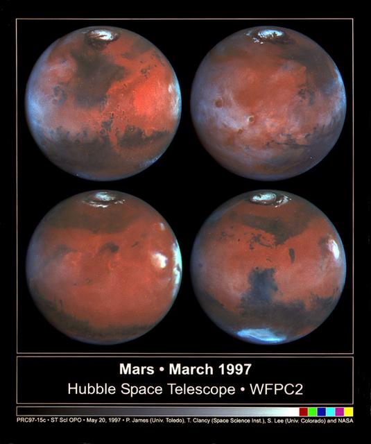
This photograph depicts four Mars views in northern summer provided by the Hubble Space Telescope (HST). The upper left view is centered on Ares Valles where Pathfinder landed in July 1997. Upper right is the Tharsis volcanic region and its associated cloud in the western half of the view. Olympus Mons lies near the western limb, Arsi Mons, Pavonis Mons Ascraeus Mons are to the west of the the center, and Valles Marineris is to the east. The lower Left view shows the Elysium volcanic region in the west, the Tharsis volcanos in East, and Cerberus is left of the center. In the lower right view, the Dark Syrtis Major region, Eysium Mons and Hellas are featured.
The three large aligned Tharsis volcanoes are Arsia Mons, Pavonis Mons and Ascreaus Mons (from south to north). There are collapse features on all three volcanoes, on the southwestern and northeastern flanks. This alignment may indicate a large fracture/vent system was responsible for the eruptions that formed all three volcanoes. The flows of originating from Arsia Mons are thought to be the youngest of the region. This VIS image shows part of the northeastern flank of Arsia Mons. The scalloped depression are most likely created by collapse of the roof of lava tubes. Lava tubes originate during eruption event, when the margins of a flow harden around a still flowing lava stream. When an eruption ends these can become hollow tubes within the flow. With time, the roof of the tube may collapse into the empty space below. The tubes are linear, so the collapse of the roof creates a linear depression. Arsia Mons is the southernmost of the Tharsis volcanoes. It is 270 miles (450km) in diameter, almost 12 miles (20km) high, and the summit caldera is 72 miles (120km) wide. For comparison, the largest volcano on Earth is Mauna Loa. From its base on the sea floor, Mauna Loa measures only 6.3 miles high and 75 miles in diameter. A large volcanic crater known as a caldera is located at the summit of all of the Tharsis volcanoes. These calderas are produced by massive volcanic explosions and collapse. The Arsia Mons summit caldera is larger than many volcanoes on Earth. The Odyssey spacecraft has spent over 15 years in orbit around Mars, circling the planet more than 69000 times. It holds the record for longest working spacecraft at Mars. THEMIS, the IR/VIS camera system, has collected data for the entire mission and provides images covering all seasons and lighting conditions. Over the years many features of interest have received repeated imaging, building up a suite of images covering the entire feature. From the deepest chasma to the tallest volcano, individual dunes inside craters and dune fields that encircle the north pole, channels carved by water and lava, and a variety of other feature, THEMIS has imaged them all. For the next several months the image of the day will focus on the Tharsis volcanoes, the various chasmata of Valles Marineris, and the major dunes fields. We hope you enjoy these images! Orbit Number: 9417 Latitude: -7.78798 Longitude: 240.585 Instrument: VIS Captured: 2004-01-28 17:39 https://photojournal.jpl.nasa.gov/catalog/PIA22151
The three large aligned Tharsis volcanoes are Arsia Mons, Pavonis Mons and Ascreaus Mons (from south to north). There are collapse features on all three volcanoes, on the southwestern and northeastern flanks. This alignment may indicate a large fracture/vent system was responsible for the eruptions that formed all three volcanoes. The flows originating from Arsia Mons are thought to be the youngest of the region. This VIS image shows part of the northeastern flank of Arsia Mons at the summit caldera. In this region the summit caldera does not have a steep margin most likely due to renewed volcanic flows within this region of the caldera. The scalloped depressions at the top of the image are most likely created by collapse of the roof of lava tubes. Lava tubes originate during eruption event, when the margins of a flow harden around a still flowing lava stream. When an eruption ends these can become hollow tubes within the flow. With time, the roof of the tube may collapse into the empty space below. The tubes are linear, so the collapse of the roof creates a linear depression. Arsia Mons is the southernmost of the Tharsis volcanoes. It is 270 miles (450km) in diameter, almost 12 miles (20km) high, and the summit caldera is 72 miles (120km) wide. For comparison, the largest volcano on Earth is Mauna Loa. From its base on the sea floor, Mauna Loa measures only 6.3 miles high and 75 miles in diameter. A large volcanic crater known as a caldera is located at the summit of all of the Tharsis volcanoes. These calderas are produced by massive volcanic explosions and collapse. The Arsia Mons summit caldera is larger than many volcanoes on Earth. The Odyssey spacecraft has spent over 15 years in orbit around Mars, circling the planet more than 69000 times. It holds the record for longest working spacecraft at Mars. THEMIS, the IR/VIS camera system, has collected data for the entire mission and provides images covering all seasons and lighting conditions. Over the years many features of interest have received repeated imaging, building up a suite of images covering the entire feature. From the deepest chasma to the tallest volcano, individual dunes inside craters and dune fields that encircle the north pole, channels carved by water and lava, and a variety of other feature, THEMIS has imaged them all. For the next several months the image of the day will focus on the Tharsis volcanoes, the various chasmata of Valles Marineris, and the major dunes fields. We hope you enjoy these images! Orbit Number: 17716 Latitude: -8.11179 Longitude: 240.245 Instrument: VIS Captured: 2005-12-12 00:29 https://photojournal.jpl.nasa.gov/catalog/PIA22155
The three large aligned Tharsis volcanoes are Arsia Mons, Pavonis Mons and Ascreaus Mons (from south to north). There are collapse features on all three volcanoes, on the southwestern and northeastern flanks. This alignment may indicate a large fracture/vent system was responsible for the eruptions that formed all three volcanoes. This VIS image shows part of the southern flank of Arsia Mons, along the center of the aligned fracture system. The scalloped depressions are most likely created by collapse of the roof of lava tubes. Lava tubes originate during eruption event, when the margins of a flow harden around a still flowing lava stream. When an eruption ends these can become hollow tubes within the flow. With time, the roof of the tube may collapse into the empty space below. The tubes are linear, so the collapse of the roof creates a linear depression. In this region, the complexity of the collapse and faulting has created a unique surface. This region has collapse depressions with floors at a variety of elevations, landslide deposits where material has continued to fall into the depression and depression sizes from small to large. Arsia Mons is the southernmost of the Tharsis volcanoes. It is 270 miles (450km) in diameter, almost 12 miles (20km) high, and the summit caldera is 72 miles (120km) wide. For comparison, the largest volcano on Earth is Mauna Loa. From its base on the sea floor, Mauna Loa measures only 6.3 miles high and 75 miles in diameter. A large volcanic crater known as a caldera is located at the summit of all of the Tharsis volcanoes. These calderas are produced by massive volcanic explosions and collapse. The Arsia Mons summit caldera is larger than many volcanoes on Earth. The Odyssey spacecraft has spent over 15 years in orbit around Mars, circling the planet more than 69000 times. It holds the record for longest working spacecraft at Mars. THEMIS, the IR/VIS camera system, has collected data for the entire mission and provides images covering all seasons and lighting conditions. Over the years many features of interest have received repeated imaging, building up a suite of images covering the entire feature. From the deepest chasma to the tallest volcano, individual dunes inside craters and dune fields that encircle the north pole, channels carved by water and lava, and a variety of other feature, THEMIS has imaged them all. For the next several months the image of the day will focus on the Tharsis volcanoes, the various chasmata of Valles Marineris, and the major dunes fields. We hope you enjoy these images! Orbit Number: 33925 Latitude: -10.6619 Longitude: 239.412 Instrument: VIS Captured: 2009-08-07 16:10 https://photojournal.jpl.nasa.gov/catalog/PIA22158
This VIS image shows a cross section of the eastern flank of Ascraeus Mons. Ascreaus Mons is the northernmost volcano of the three large Tharsis volcanoes. In order from north to south the volcanoes are Ascreaus Mons, Pavonis Mons and Arsia Mons. All three volcanoes form a line located along a tectonic bulge caused by extensional forces in the region. Along this trend there are increased tectonic features, collapse features, and additional lava flows that arose from the flanks of the volcanoes rather than just the summit. Like the other large volcanoes in the region, Ascraeus Mons is a shield volcano. Shield volcanoes are formed by lava flows originating near or at the summit, building up layers upon layers of lava. In shield volcanoes summit calderas are typically formed where the surface collapses into the void formed by an emptied magma chamber. Ascraeus Mons is the largest of the three volcanoes with a summit of 18km (11 miles) and a width of 460 km (286 miles). For comparison Mauna Kea – the tallest volcano on Earth – is 10 km tall (6.2 miles). Orbit Number: 94915 Latitude: 12.2183 Longitude: 257.543 Instrument: VIS Captured: 2023-05-08 14:33 https://photojournal.jpl.nasa.gov/catalog/PIA26218
Today's VIS image shows Biblis Patera, the summit caldera of the volcano Biblis Tholus. This volcano is located west of Pavonis Mons and is just one of the numerous volcanoes found in the Tharsis region. Orbit Number: 77870 Latitude: 2.21414 Longitude: 236.308 Instrument: VIS Captured: 2019-07-05 03:02 https://photojournal.jpl.nasa.gov/catalog/PIA23393
![The linear features in this VIS image are called Oti Fossae. Oti Fossae is located on the eastern flank of Arsia Mons and aligns with the regional northeast/southwest trend of the major Tharsis volcanoes. Graben are formed by extension of the crust and faulting. When large amounts of pressure or tension are applied to rocks on timescales that are fast enough that the rock cannot respond by deforming, the rock breaks along faults. In the case of a graben, two parallel faults are formed by extension of the crust and the rock in between the faults drops downward into the space created by the extension. The crustal deformation in this region was from the inflation of the surface by the rise of magma that created the Tharsis volcanoes. Arsia Mons is the southernmost and youngest of the three large, aligned Tharsis volcanoes [Arsia Mons, Pavonis Mons and Ascreaus Mons, from south to north]. This alignment may indicate a large fracture/vent system was responsible for the eruptions that formed all three volcanoes. Arsia Mons is 270 miles (450km) in diameter, almost 12 miles (20km) high, and the summit caldera is 72 miles (120km) wide. For comparison, the largest volcano on Earth is Mauna Loa. From its base on the sea floor, Mauna Loa measures only 6.3 miles high and 75 miles in diameter. Orbit Number: 89712 Latitude: -8.73951 Longitude: 243.785 Instrument: VIS Captured: 2022-03-06 04:33 https://photojournal.jpl.nasa.gov/catalog/PIA25392](https://images-assets.nasa.gov/image/PIA25392/PIA25392~medium.jpg)
The linear features in this VIS image are called Oti Fossae. Oti Fossae is located on the eastern flank of Arsia Mons and aligns with the regional northeast/southwest trend of the major Tharsis volcanoes. Graben are formed by extension of the crust and faulting. When large amounts of pressure or tension are applied to rocks on timescales that are fast enough that the rock cannot respond by deforming, the rock breaks along faults. In the case of a graben, two parallel faults are formed by extension of the crust and the rock in between the faults drops downward into the space created by the extension. The crustal deformation in this region was from the inflation of the surface by the rise of magma that created the Tharsis volcanoes. Arsia Mons is the southernmost and youngest of the three large, aligned Tharsis volcanoes [Arsia Mons, Pavonis Mons and Ascreaus Mons, from south to north]. This alignment may indicate a large fracture/vent system was responsible for the eruptions that formed all three volcanoes. Arsia Mons is 270 miles (450km) in diameter, almost 12 miles (20km) high, and the summit caldera is 72 miles (120km) wide. For comparison, the largest volcano on Earth is Mauna Loa. From its base on the sea floor, Mauna Loa measures only 6.3 miles high and 75 miles in diameter. Orbit Number: 89712 Latitude: -8.73951 Longitude: 243.785 Instrument: VIS Captured: 2022-03-06 04:33 https://photojournal.jpl.nasa.gov/catalog/PIA25392
The three large aligned Tharsis volcanoes are Arsia Mons, Pavonis Mons and Ascreaus Mons (from south to north). There are collapse features on all three volcanoes, on the southwestern and northeastern flanks. This alignment may indicate a large fracture/vent system was responsible for the eruptions that formed all three volcanoes. This VIS image shows part of the southern flank of Arsia Mons. The linear features are graben. Arsia Mons is the southernmost of the Tharsis volcanoes. It is 270 miles (450km) in diameter, almost 12 miles (20km) high, and the summit caldera is 72 miles (120km) wide. For comparison, the largest volcano on Earth is Mauna Loa. From its base on the sea floor, Mauna Loa measures only 6.3 miles high and 75 miles in diameter. A large volcanic crater known as a caldera is located at the summit of all of the Tharsis volcanoes. These calderas are produced by massive volcanic explosions and collapse. The Arsia Mons summit caldera is larger than many volcanoes on Earth. Orbit Number: 91484 Latitude: -10.1537 Longitude: 242.255 Instrument: VIS Captured: 2022-07-30 02:19 https://photojournal.jpl.nasa.gov/catalog/PIA25603
This image from NASA Mars Reconnaissance Orbite is centered on a small cone on the side of one of Mars giant shield volcanoes. The cone shows some layers of hard rock but most of it is made of relatively soft material.
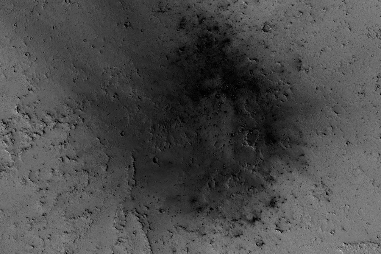
NASA's Mars Reconnaissance Orbiter has been observing Mars in sharp detail for more than a decade, enabling it to document many types of changes, such as the way winds alter the appearance of this recent impact site. The space-rock impact that created this blast zone occurred sometime between September 2005 and February 2006, as bracketed by observations made with the Mars Orbiter Camera on NASA's Mars Global Surveyor spacecraft. The location is between two large volcanos, named Ascraeus Mons and Pavonis Mons, in a dusty area of the Tharsis region of Mars. During the period from 2007 to 2012, winds blowing through the pass between the volcanoes darkened some regions and brightened others, probably by removing and depositing dust. The view covers an area about 1.0 mile (1.6 kilometers) across, at 7 degrees north latitude, 248 degrees east longitude. North is toward the top. An animation is availalble at http://photojournal.jpl.nasa.gov/catalog/PIA21267
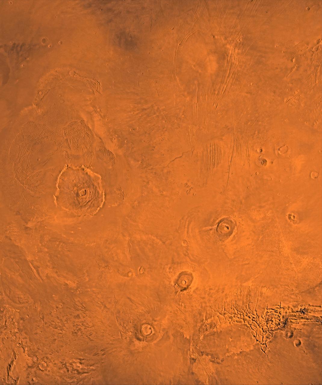
A color image of the Tharsis region of Mars; north toward top. The scene shows the Tharsis bulge, a huge ridge covered by the 3 large aligned Tharsis Montes shield volcanoes (from lower left to right): Arsia, Pavonis, and Ascraeus Mons. To the left of the Tharsis Montes lies the huge Olympus Mons shield volcano, followed clockwise by Alba Patera (north center), several smaller volcanoes, and the linear depressions of Mareotis and Tempe Fossae (upper right). This image is a composite of Viking medium-resolution images in black and white and low-resolution images in color. The image extends from latitude 50 degrees N. to 20 degrees S. and from longitude 85 degrees to 150 degrees. Mercator projection is used between latitudes 20 degrees S. and 30 degrees N.; Lambert projection is used above latitude 30 degrees N. The Tharsis bulge encompasses the most intensely and most recently active volcanic region of the planet. Each Tharsis Montes volcano is 350-400 km in diameter and about 17 km above the surrounding plain. The volcanoes are about 700 km apart and appear to be above a major northeast-trending fracture zone along the bulge, now buried by volcanic deposits. Olympus Mons (left center) is the largest known volcano in the Solar System. It is 27 km high, over 600 km at the base, and is surrounded by a well-defined scarp that is up to 6 km high. The summit calderas (central depressions) of all four volcanoes probably formed from recurrent collapse following drainage of magma resulting from flank eruptions. 1,600-km-diameter Alba Patera (north center) far exceeds any other known volcano in areal extent; it covers eight times the area of Olympus Mons but reaches only about 6 km in height. Fossae (linear depressions) of the Tharsis area are fault-bound graben formed by upwarping of the Tharsis bulge. http://photojournal.jpl.nasa.gov/catalog/PIA00408
The THEMIS VIS camera contains 5 filters. The data from different filters can be combined in multiple ways to create a false color image. These false color images may reveal subtle variations of the surface not easily identified in a single band image. Today's false color image shows part of the vast volcanic plains in the Tharsis region, in this case east of Pavonis Mons. The mottled appearance of the image is being caused by high altitude cloud cover. These clouds will be primarily composed of ice rather than dust. The THEMIS VIS camera is capable of capturing color images of the Martian surface using five different color filters. In this mode of operation, the spatial resolution and coverage of the image must be reduced to accommodate the additional data volume produced from using multiple filters. To make a color image, three of the five filter images (each in grayscale) are selected. Each is contrast enhanced and then converted to a red, green, or blue intensity image. These three images are then combined to produce a full color, single image. Because the THEMIS color filters don't span the full range of colors seen by the human eye, a color THEMIS image does not represent true color. Also, because each single-filter image is contrast enhanced before inclusion in the three-color image, the apparent color variation of the scene is exaggerated. Nevertheless, the color variation that does appear is representative of some change in color, however subtle, in the actual scene. Note that the long edges of THEMIS color images typically contain color artifacts that do not represent surface variation. Orbit Number: 85818 Latitude: 6.41017 Longitude: 260.984 Instrument: VIS Captured: 2021-04-19 13:31 https://photojournal.jpl.nasa.gov/catalog/PIA25096
![The linear features in the bottom half of this VIS image are called Oti Fossae. Oti Fossae is located on the eastern flank of Arsia Mons and aligns with the regional northeast/southwest trend of the major Tharsis volcanoes. Fossae are typically tectonic features termed graben. Graben are formed by extension of the crust and faulting. When large amounts of pressure or tension are applied to rocks on timescales that are fast enough that the rock cannot respond by deforming, the rock breaks along faults. In the case of a graben, two parallel faults are formed by extension of the crust and the rock in between the faults drops downward into the space created by the extension. The crustal deformation in this region was from the inflation of the surface by the rise of magma that created the Tharsis volcanoes. Arsia Mons is the southernmost and youngest of the three large, aligned Tharsis volcanoes [Arsia Mons, Pavonis Mons and Ascreaus Mons, from south to north]. This alignment may indicate a large fracture/vent system was responsible for the eruptions that formed all three volcanoes. Arsia Mons is 270 miles (450km) in diameter, almost 12 miles (20km) high, and the summit caldera is 72 miles (120km) wide. For comparison, the largest volcano on Earth is Mauna Loa. From its base on the sea floor, Mauna Loa measures only 6.3 miles high and 75 miles in diameter. Orbit Number: 94404 Latitude: -8.85515 Longitude: 242.188 Instrument: VIS Captured: 2023-03-27 12:39 https://photojournal.jpl.nasa.gov/catalog/PIA26025](https://images-assets.nasa.gov/image/PIA26025/PIA26025~medium.jpg)
The linear features in the bottom half of this VIS image are called Oti Fossae. Oti Fossae is located on the eastern flank of Arsia Mons and aligns with the regional northeast/southwest trend of the major Tharsis volcanoes. Fossae are typically tectonic features termed graben. Graben are formed by extension of the crust and faulting. When large amounts of pressure or tension are applied to rocks on timescales that are fast enough that the rock cannot respond by deforming, the rock breaks along faults. In the case of a graben, two parallel faults are formed by extension of the crust and the rock in between the faults drops downward into the space created by the extension. The crustal deformation in this region was from the inflation of the surface by the rise of magma that created the Tharsis volcanoes. Arsia Mons is the southernmost and youngest of the three large, aligned Tharsis volcanoes [Arsia Mons, Pavonis Mons and Ascreaus Mons, from south to north]. This alignment may indicate a large fracture/vent system was responsible for the eruptions that formed all three volcanoes. Arsia Mons is 270 miles (450km) in diameter, almost 12 miles (20km) high, and the summit caldera is 72 miles (120km) wide. For comparison, the largest volcano on Earth is Mauna Loa. From its base on the sea floor, Mauna Loa measures only 6.3 miles high and 75 miles in diameter. Orbit Number: 94404 Latitude: -8.85515 Longitude: 242.188 Instrument: VIS Captured: 2023-03-27 12:39 https://photojournal.jpl.nasa.gov/catalog/PIA26025
![The linear features in the bottom half of this VIS image are called Oti Fossae. Oti Fossae is located on the eastern flank of Arsia Mons and aligns with the regional northeast/southwest trend of the major Tharsis volcanoes. Fossae are typically tectonic features termed graben. Graben are formed by extension of the crust and faulting. When large amounts of pressure or tension are applied to rocks on timescales that are fast enough that the rock cannot respond by deforming, the rock breaks along faults. In the case of a graben, two parallel faults are formed by extension of the crust and the rock in between the faults drops downward into the space created by the extension. The crustal deformation in this region was from the inflation of the surface by the rise of magma that created the Tharsis volcanoes. Arsia Mons is the southernmost and youngest of the three large, aligned Tharsis volcanoes [Arsia Mons, Pavonis Mons and Ascreaus Mons, from south to north]. This alignment may indicate a large fracture/vent system was responsible for the eruptions that formed all three volcanoes. Arsia Mons is 270 miles (450km) in diameter, almost 12 miles (20km) high, and the summit caldera is 72 miles (120km) wide. For comparison, the largest volcano on Earth is Mauna Loa. From its base on the sea floor, Mauna Loa measures only 6.3 miles high and 75 miles in diameter. Orbit Number: 94978 Latitude: -8.70852 Longitude: 242.873 Instrument: VIS Captured: 2023-05-13 18:56 https://photojournal.jpl.nasa.gov/catalog/PIA26224](https://images-assets.nasa.gov/image/PIA26224/PIA26224~medium.jpg)
The linear features in the bottom half of this VIS image are called Oti Fossae. Oti Fossae is located on the eastern flank of Arsia Mons and aligns with the regional northeast/southwest trend of the major Tharsis volcanoes. Fossae are typically tectonic features termed graben. Graben are formed by extension of the crust and faulting. When large amounts of pressure or tension are applied to rocks on timescales that are fast enough that the rock cannot respond by deforming, the rock breaks along faults. In the case of a graben, two parallel faults are formed by extension of the crust and the rock in between the faults drops downward into the space created by the extension. The crustal deformation in this region was from the inflation of the surface by the rise of magma that created the Tharsis volcanoes. Arsia Mons is the southernmost and youngest of the three large, aligned Tharsis volcanoes [Arsia Mons, Pavonis Mons and Ascreaus Mons, from south to north]. This alignment may indicate a large fracture/vent system was responsible for the eruptions that formed all three volcanoes. Arsia Mons is 270 miles (450km) in diameter, almost 12 miles (20km) high, and the summit caldera is 72 miles (120km) wide. For comparison, the largest volcano on Earth is Mauna Loa. From its base on the sea floor, Mauna Loa measures only 6.3 miles high and 75 miles in diameter. Orbit Number: 94978 Latitude: -8.70852 Longitude: 242.873 Instrument: VIS Captured: 2023-05-13 18:56 https://photojournal.jpl.nasa.gov/catalog/PIA26224
The three large aligned Tharsis volcanoes are Arsia Mons, Pavonis Mons and Ascreaus Mons (from south to north). There are collapse features on all three volcanoes, on the southwestern and northeastern flanks. This alignment may indicate a large fracture/vent system was responsible for the eruptions that formed all three volcanoes. This VIS image shows part of the northwestern flank of Arsia Mons, west of the aligned fracture system. The scalloped depressions and lines of craters are most likely created by collapse of the roof of lava tubes. Lava tubes originate during eruption event, when the margins of a flow harden around a still flowing lava stream. When an eruption ends these can become hollow tubes within the flow. With time, the roof of the tube may collapse into the empty space below. The tubes are linear, so the collapse of the roof creates a linear depression. In this region, the complexity of the collapse and faulting has created a unique surface. This region has collapse depressions with floors at a variety of elevations and depression sizes from small to large. Arsia Mons is the southernmost of the Tharsis volcanoes. It is 270 miles (450km) in diameter, almost 12 miles (20km) high, and the summit caldera is 72 miles (120km) wide. For comparison, the largest volcano on Earth is Mauna Loa. From its base on the sea floor, Mauna Loa measures only 6.3 miles high and 75 miles in diameter. A large volcanic crater known as a caldera is located at the summit of all of the Tharsis volcanoes. These calderas are produced by massive volcanic explosions and collapse. The Arsia Mons summit caldera is larger than many volcanoes on Earth. Orbit Number: 93113 Latitude: -6.63675 Longitude: 238.403 Instrument: VIS Captured: 2022-12-11 04:35 https://photojournal.jpl.nasa.gov/catalog/PIA25817
The three large aligned Tharsis volcanoes are Arsia Mons, Pavonis Mons and Ascreaus Mons (from south to north). There are collapse features on all three volcanoes, on the southwestern and northeastern flanks. This alignment may indicate a large fracture/vent system was responsible for the eruptions that formed all three volcanoes. This VIS image shows part of the southern flank of Arsia Mons, along the center of the aligned fracture system. The scalloped depressions are most likely created by collapse of the roof of lava tubes. Lava tubes originate during eruption event, when the margins of a flow harden around a still flowing lava stream. When an eruption ends these can become hollow tubes within the flow. With time, the roof of the tube may collapse into the empty space below. The tubes are linear, so the collapse of the roof creates a linear depression. In this region, the complexity of the collapse and faulting has created a unique surface. This region has collapse depressions with floors at a variety of elevations and depression sizes from small to large. Arsia Mons is the southernmost of the Tharsis volcanoes. It is 270 miles (450km) in diameter, almost 12 miles (20km) high, and the summit caldera is 72 miles (120km) wide. For comparison, the largest volcano on Earth is Mauna Loa. From its base on the sea floor, Mauna Loa measures only 6.3 miles high and 75 miles in diameter. A large volcanic crater known as a caldera is located at the summit of all of the Tharsis volcanoes. These calderas are produced by massive volcanic explosions and collapse. The Arsia Mons summit caldera is larger than many volcanoes on Earth. Orbit Number: 88040 Latitude: -6.88266 Longitude: 240.595 Instrument: VIS Captured: 2021-10-19 12:23 https://photojournal.jpl.nasa.gov/catalog/PIA25116
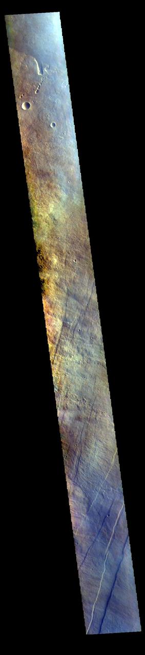
The THEMIS VIS camera contains 5 filters. The data from different filters can be combined in multiple ways to create a false color image. These false color images may reveal subtle variations of the surface not easily identified in a single band image. Today's false color image shows part of the flank of Arsia Mons. The three large aligned Tharsis volcanoes are Arsia Mons, Pavonis Mons and Ascreaus Mons (from south to north). There are collapse features on all three volcanoes, on the southwestern and northeastern flanks. This alignment may indicate a large fracture/vent system was responsible for the eruptions that formed all three volcanoes. This VIS image shows part of the eastern flank of Arsia Mons, west of the aligned fracture system. Arsia Mons is the southernmost of the Tharsis volcanoes. It is 270 miles (450km) in diameter, almost 12 miles (20km) high, and the summit caldera is 72 miles (120km) wide. For comparison, the largest volcano on Earth is Mauna Loa. From its base on the sea floor, Mauna Loa measures only 6.3 miles high and 75 miles in diameter. A large volcanic crater known as a caldera is located at the summit of all of the Tharsis volcanoes. These calderas are produced by massive volcanic explosions and collapse. The Arsia Mons summit caldera is larger than many volcanoes on Earth. The THEMIS VIS camera is capable of capturing color images of the Martian surface using five different color filters. In this mode of operation, the spatial resolution and coverage of the image must be reduced to accommodate the additional data volume produced from using multiple filters. To make a color image, three of the five filter images (each in grayscale) are selected. Each is contrast enhanced and then converted to a red, green, or blue intensity image. These three images are then combined to produce a full color, single image. Because the THEMIS color filters don't span the full range of colors seen by the human eye, a color THEMIS image does not represent true color. Also, because each single-filter image is contrast enhanced before inclusion in the three-color image, the apparent color variation of the scene is exaggerated. Nevertheless, the color variation that does appear is representative of some change in color, however subtle, in the actual scene. Note that the long edges of THEMIS color images typically contain color artifacts that do not represent surface variation. Orbit Number: 94404 Latitude: -8.85515 Longitude: 242.188 Instrument: VIS Captured: 2023-03-27 12:39 https://photojournal.jpl.nasa.gov/catalog/PIA26129
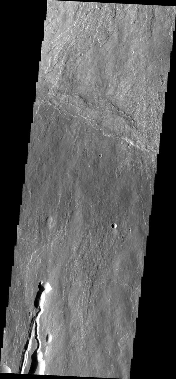
This image shows part of the southern flank of Ascraeus Mons. The feature at the bottom of the image is a collapse feature. These features can be caused by several processes. The ceiling of lava tubes can collapse into the open space left after the last flow. Tectonic activity can occur, and blocks of material can drop down between faults. The tectonic features are called graben. All three of the Tharsis volcanoes (Ascraeus, Pavonis and Arsia mons) are aligned along a northeast/southwest trend. The largest region of collapse features on each of the three volcanoes are located along this trend. The Odyssey spacecraft has spent over 15 years in orbit around Mars, circling the planet more than 69000 times. It holds the record for longest working spacecraft at Mars. THEMIS, the IR/VIS camera system, has collected data for the entire mission and provides images covering all seasons and lighting conditions. Over the years many features of interest have received repeated imaging, building up a suite of images covering the entire feature. From the deepest chasma to the tallest volcano, individual dunes inside craters and dune fields that encircle the north pole, channels carved by water and lava, and a variety of other feature, THEMIS has imaged them all. For the next several months the image of the day will focus on the Tharsis volcanoes, the various chasmata of Valles Marineris, and the major dunes fields. We hope you enjoy these images! Orbit Number: 18376 Latitude: 9.77446 Longitude: 254.826 Instrument: VIS Captured: 2006-02-04 10:32 https://photojournal.jpl.nasa.gov/catalog/PIA21824