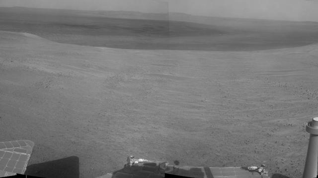
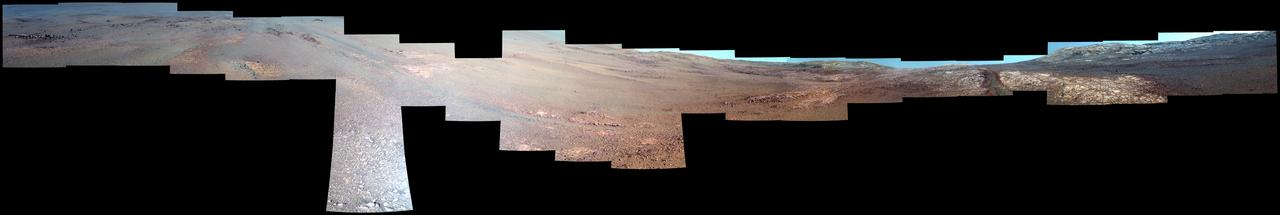
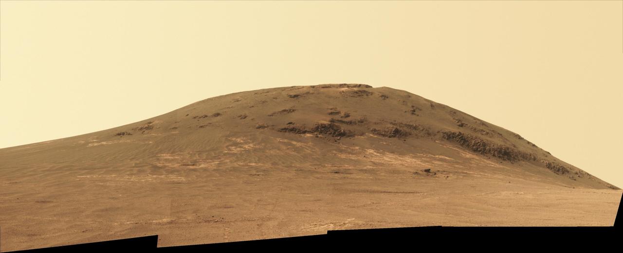
"Perseverance Valley" lies just on the other side of the dip in the crater rim visible in the left half of this 360-degree panorama from the Navigation Camera (Navcam) on NASA's Mars Exploration Rover Opportunity. As the rover arrived at this area in early May 2017, researchers began looking for clues about what process carved the valley. The rover team plans to drive Opportunity all the way down the valley into the interior of Endeavour Crater. The foreground and the area to the right are on the plain just outside of Endeavour Crater. The high point near the center of the image is called "Winnemucca," part of an Endeavour rim segment called "Cape Byron." Endeavour's interior and distant eastern rim are visible at upper left, above the notched portion of the western rim that sits directly above Perseverance Valley. The rover's Navcam took the component images of this scene on May 2 and May 3, 2017, during the 4,718th and 4,719th Martian days, or sols, of Opportunity's work on Mars, two days before a drive that brought Opportunity to the head of the valley. https://photojournal.jpl.nasa.gov/catalog/PIA21495
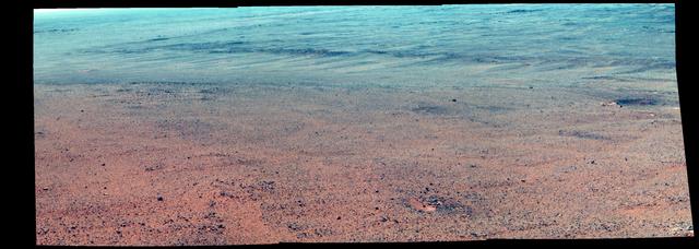
Textured rows on the ground in this portion of "Perseverance Valley" are under investigation by NASA's Mars Exploration Rover Opportunity, which used its Navigation Camera (Navcam) to take the component images of this downhill-looking scene. The rover took this image on Jan. 4, 2018, during the 4,958th Martian day, or sol, of its work on Mars, looking downhill from a position about one-third of the way down the valley. Perseverance Valley descends the inboard slope of the western rim of Endeavour Crater. A view on the same sol with the rover's front Hazard Avoidance Camera includes ground even closer to the rover at this site. Opportunity was still working close by as it reached the mission's Sol 5,000 (Feb. 16, 2018). In the portion of the valley seen here, soil and gravel have been shaped into a striped pattern in the foreground and partially bury outcrops visible in the midfield. The long dimensions of the stripes are approximately aligned with the downhill direction. The striped pattern resembles a type of feature on Earth (such as on Hawaii's Mauna Kea) that is caused by repeated cycles of freezing and thawing, though other possible origins are also under consideration for the pattern in Perseverance Valley. The view is spans from north on the left to east-southeast on the right. For scale, the foreground rock clump in the lower right is about 11 inches (28 centimeters) in width. https://photojournal.jpl.nasa.gov/catalog/PIA22217
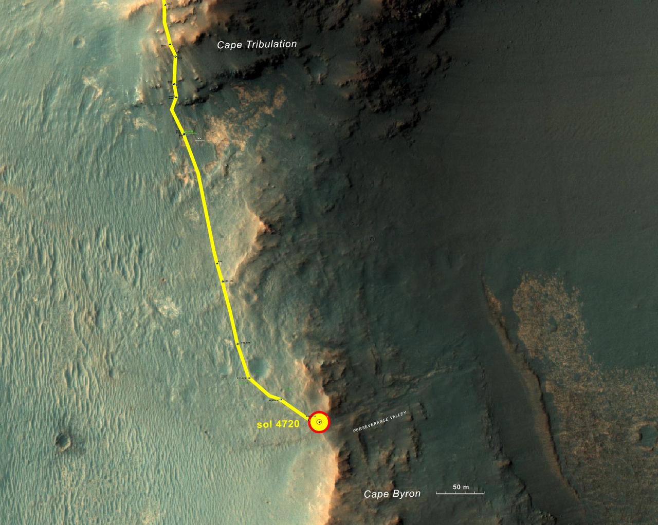
This graphic shows the route that NASA's Mars Exploration Rover Opportunity drove in its final approach to 'Perseverance Valley' on the western rim of Endeavour Crater. The map covers an area about four-tenths of a mile (two-thirds of a kilometer) wide, with the interior of the crater on the right. Opportunity entered this mapped area from the north along the gold traverse line on March 21, 2017, approaching the southern tip of the "Cape Tribulation" segment of Endeavour's rim. It reached the top of "Perseverance Valley" with a drive on Sol 4720 (the 4,720th Martian day) of the mission, on May 4, 2017. https://photojournal.jpl.nasa.gov/catalog/PIA21496
This view from within "Perseverance Valley," on the inner slope of the western rim of Endurance Crater on Mars, includes wheel tracks from the Opportunity rover's descent of the valley. The Panoramic Camera (Pancam) on Opportunity's mast took the component images of the scene during the period Sept. 4 through Oct. 6, 2017, corresponding to sols (Martian days) 4840 through 4871 of the rover's work on Mars. Perseverance Valley is a system of shallow troughs descending eastward about the length of two football fields from the crest of the crater rim to the floor of the crater. This panorama spans from northeast on the left to northwest on the right, including portions of the crater floor (eastward) in the left half and of the rim (westward) in the right half. Opportunity began descending Perseverance Valley in mid-2017 (see map) as part of an investigation into how the valley formed. Rover wheel tracks are darker brown, between two patches of bright bedrock, receding toward the horizon in the right half of the scene. This view combines multiple images taken through three different Pancam filters. The selected filters admit light centered on wavelengths of 753 nanometers (near-infrared), 535 nanometers (green) and 432 nanometers (violet). The three color bands are combined here to show approximately true color. A map and high-resolution TIFF file is available at https://photojournal.jpl.nasa.gov/catalog/PIA22074
This enhanced-color view from within "Perseverance Valley," on the inner slope of the western rim of Endurance Crater on Mars, includes wheel tracks from the Opportunity rover's descent of the valley. The Panoramic Camera (Pancam) on Opportunity's mast took the component images of the scene during the period Sept. 4 through Oct. 6, 2017, corresponding to sols (Martian days) 4840 through 4871 of the rover's work on Mars. Perseverance Valley is a system of shallow troughs descending eastward about the length of two football fields from the crest of the crater rim to the floor of the crater. This panorama spans from northeast on the left to northwest on the right, including portions of the crater floor (eastward) in the left half and of the rim (westward) in the right half. Opportunity began descending Perseverance Valley in mid-2017 (see map) as part of an investigation into how the valley formed. Rover wheel tracks are darker brown, between two patches of bright bedrock, receding toward the horizon in the right half of the scene. This view combines multiple images taken through three different Pancam filters. The selected filters admit light centered on wavelengths of 753 nanometers (near-infrared), 535 nanometers (green) and 432 nanometers (violet). The three color bands are combined here with enhancement to make differences in surface materials easier to see. A map and full-resolution TIFF file are available at https://photojournal.jpl.nasa.gov/catalog/PIA22073
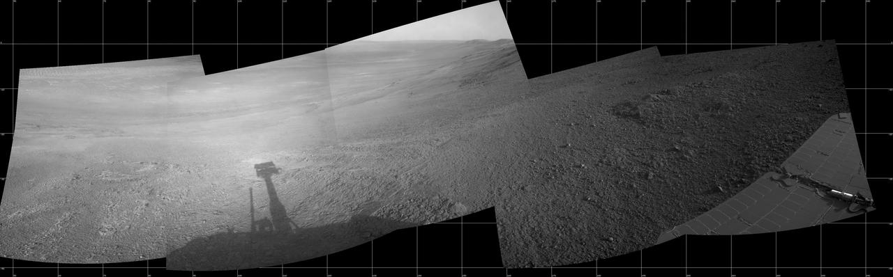
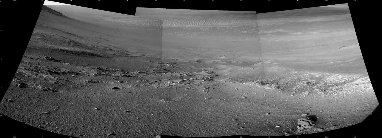
This mosaic scene combining five images from the navigation camera (Navcam) on NASA's Mars Exploration Rover Opportunity shows a view from inside the upper end of "Perseverance Valley" on the inner slope of Endeavour Crater's western rim. The valley is the main destination for the current two-year extension of the 13-year-old Opportunity mission on Mars. It was likely carved long ago by a fluid, such as water, water-lubricated debris or wind. The rover team is using Opportunity to learn more about the processes that shaped the valley. Plans call for driving the rover down the full length of the valley, about twice the length of a football field. Opportunity entered the top end of Perseverance Valley after studying the area just outside the crater rim above the valley during the spring and early summer of 2017. The images combined into this scene were taken on July 7, 2017, during the 4,782nd Martian day, or sol, of the rover's work on Mars. Opportunity had driven about 45 feet (13.8 meters) earlier that same sol. The portion of this scene to the left of the shadow of the rover's mast shows Perseverance Valley descending to the floor of Endeavour Crater. Foreground areas in the middle and right sections of the scene shows terrain details in the upper end of the valley. More distant in the center section, the rim of Endeavour Crater extends southeastward. The full scene spans from northeast at left to southwest at right. https://photojournal.jpl.nasa.gov/catalog/PIA21724

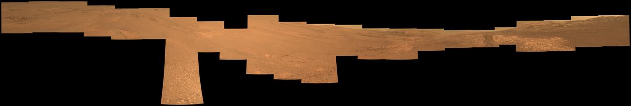
Toward the right side of this enhanced-color scene is a broad notch in the crest of the western rim of Endeavour Crater. Wheel tracks in that area were left by NASA's Mars Exploration Rover Opportunity as it observed "Perseverance Valley" from above in the spring of 2017. The valley is a major destination for the rover's extended mission. It descends out of sight on the inner slope of the rim, extending down and eastward from that notch. Opportunity's panoramic camera (Pancam) took the component images for this view from a position outside the crater during the span of June 7 to June 19, 2017, sols 4753 to 4765 of the rover's work on Mars. This scene includes features that might have been ancient channels from water, ice or wind moving toward the notch in the rim, which might have been a spillway. Perseverance Valley, just on the other side, was likely carved by action of some fluid, such as water, water-lubricated debris, or wind. The mission is investigating to learn more about that process from evidence in place. The panorama spans about three-fourths of a full-circle view, from southeastward on the left, through westward in the middle, to northeastward on the right. High points visible on the rim of Endeavour Crater include "Winnemucca" on the left and "Cape Tribulation" on the right. Winnemucca is part of the "Cape Byron" portion of the crater rim. The horizon at far right extends across the floor of Endeavour Crater, which is about 14 miles (22 kilometers) in diameter. Opportunity has been investigating sites on and near the western rim of Endeavour since 2011, following seven years of exploring smaller craters after its 2004 landing. This view merges exposures taken through three of the Pancam's color filters, centered on wavelengths of 753 nanometers (near-infrared), 535 nanometers (green) and 432 nanometers (violet). Color is enhanced in this version to make differences in surface materials more easily visible. The rover team calls this the "Sprained Ankle" panorama because the images were collected during a driving moratorium while engineers diagnosed a temporary steering stall with one front wheel pointed outward more than 30 degrees. The team was able to straighten the wheel to point straight ahead, and then resumed driving. The location from which this scene was recorded is labeled as "Sol 4752" on a later traverse map. Opportunity subsequently entered the upper end of Perseverance Valley and returned views looking down the valley and back up toward the rim crest from the location it reached on July 7 (Sol 4782). https://photojournal.jpl.nasa.gov/catalog/PIA21722
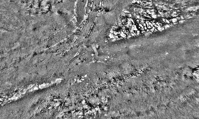
This mosaic was stitched together using images from the Navigation Camera, or Navcam, on NASA's Opportunity rover. The scene shows the rover's tracks made in Perseverance Valley between Sols 5,000 and 5,030. The mosaic has a resolution of about 1 centimeter per pixel; the scene width is 66 feet (20 meters) while the scene height is 39 feet (12 meters). The rover wheel tracks are about 3 feet (1 meter) apart. Shading differences between frames have been adjusted so subtle surface details are more visible. https://photojournal.jpl.nasa.gov/catalog/PIA23246
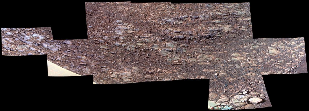
This patch of rocky Martian ground on the floor of "Perseverance Valley" on the inner slope of the western rim of Endurance Crater slopes steeply downhill from left to right. Some textures seen here, including striations just above and parallel to the edge of a solar panel at far left, may be due to abrasion by wind-driven sand. Researchers interpret them as possible signs of past winds blowing from right to left, up and out of the crater, which currently hosts sand dunes on its central floor. The view spans about 11.5 feet (3.5 meters) from left to right and is presented in enhanced color to make differences in surface materials easier to see. The Panoramic Camera (Pancam) on NASA's Mars Exploration Rover Opportunity took the component images of this scene during the period Oct. 13 through Oct. 20, 2017, corresponding to sols (Martian days) 4878 through 4884 of the rover's work on Mars. Opportunity entered the upper end of Perseverance Valley in July 2017 for several months of investigating how it formed. The valley is a system of shallow troughs extending about the length of two football fields down the crater rim's steep inner slope. Endurance Crater is about 14 miles (22 kilometers) in diameter. Opportunity has been exploring features on its western rim since 2011, after investigating a series of smaller craters beginning with the one it landed in on Jan. 25, 2004, Universal Time (Jan. 24, PST). The origin of Perseverance Valley is unknown, but some observed features suggest that water might have played a role in the past. Opportunity is descending the steep valley, making observations along the way that could help illuminate the origin of this feature. The bedrock target area in this view is called "La Bajada." The image combines exposures taken through three Pancam filters, centered at wavelengths of 753 nanometers (near-infrared), 535 nanometers (green) and 432 nanometers (violet). https://photojournal.jpl.nasa.gov/catalog/PIA22072

This June 2017 stereo scene from NASA's Mars Exploration Rover Opportunity rover shows the area just above "Perseverance Valley" on the rim of Endeavour Crater. The view combines images from the left eye and right eye of the rover's panoramic camera (Pancam) to appear three-dimensional when seen through blue-red glasses with the red lens on the left. Toward the right side of the scene is a broad notch in the crest of the crater's rim. Opportunity left wheel tracks in that area as it observed Perseverance Valley from above in the spring of 2017. The valley is a major destination for the rover's extended mission. It descends out of sight on the inner slope of the rim, extending down and eastward from that notch. Opportunity's Pancam took the component images for this view from a position outside the crater during the span of June 7 to June 19, 2017, sols 4753 to 4765 of the rover's work on Mars. This scene includes features that might have been ancient channels from water, ice or wind moving toward the notch in the rim, which might have been a spillway. Perseverance Valley, just on the other side, was likely carved by action of some fluid, such as water, water-lubricated debris, or wind. The mission is investigating to learn more about that process from evidence in place. The panorama spans about three-fourths of a full-circle view, from southeastward on the left, through westward in the middle, to northeastward on the right. High points visible on the rim of Endeavour Crater include "Winnemucca" on the left and "Cape Tribulation" on the right. Winnemucca is part of the "Cape Byron" portion of the crater rim. The horizon at far right extends across the floor of Endeavour Crater, which is about 14 miles (22 kilometers) in diameter. Opportunity has been investigating sites on and near the western rim of Endeavour since 2011, following seven years of exploring smaller craters after its 2004 landing The rover team calls this the "Sprained Ankle" panorama because the images were collected during a driving moratorium while engineers diagnosed a temporary steering stall with one front wheel pointed outward more than 30 degrees. The team was able to straighten the wheel to point straight ahead, and then resumed driving. The location from which this scene was recorded is labeled as "Sol 4752" on a later traverse map. Opportunity subsequently entered the upper end of Perseverance Valley and returned views looking down the valley and back up toward the rim crest from the location it reached on July 7 (Sol 4782). You need 3D glasses to view this image. https://photojournal.jpl.nasa.gov/catalog/PIA21721
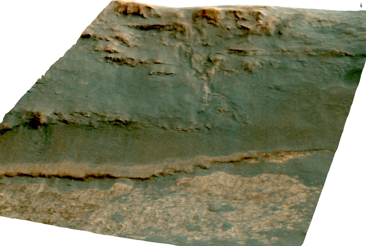
The channel descending a Martian slope in this perspective view is "Perseverance Valley," which is the study area of NASA's Mars Exploration Rover Opportunity as the rover passes its 5,000th sol, or Martian day, of its mission on the surface of Mars. The view was produced by overlaying an image take from orbit onto a topographic model with five-fold vertical exaggeration to emphasize the shapes on the rim of a large crater that have been cut by the valley on the inboard slope of the rim. The image used is from the High Resolution Imaging Science Experiment (HiRISE) camera on NASA's Mars Reconnaissance Orbiter, observation ESP_036753_1775. The crest of a portion of the western rim of Endeavour Crater is at the top of the view, and the floor of the crater is in the foreground, below an erosion-resistant bench perched beneath the valley. The crater is about 14 miles (22 kilometers) in diameter. This perspective view is from within the crater, looking westward. It spans an area about a quarter mile (400 meters) wide from left to right (south to north). The interior rim slopes about 15 to 20 degrees. Figure 1 is an annotated version indicating Perseverance Valley and the bench, plus Opportunity's locations on Sol 5,000 (Feb. 16, 2018) and on Sol 4,958 (Jan. 4, 2018). On Sol 4958, the rover took images with its Navigation Camera and its Hazard Avoidance Camera showing textures of possible stone stripes. The graphic was created at Washington University in St. Louis. A map of a slightly larger portion of the crater rim shows the location of Perseverance Valley and Opportunity's 2017 approach path. As of its Sol 5,000, Opportunity has driven 28 miles (45 kilometers) since its January 2004 landing, in what was planned as a 90-sol mission. https://photojournal.jpl.nasa.gov/catalog/PIA22216
Toward the right side of this enhanced-color scene is a broad notch in the crest of the western rim of Endeavour Crater. Wheel tracks in that area were left by NASA's Mars Exploration Rover Opportunity as it observed "Perseverance Valley" from above in the spring of 2017. The valley is a major destination for the rover's extended mission. It descends out of sight on the inner slope of the rim, extending down and eastward from that notch. Opportunity's panoramic camera (Pancam) took the component images for this view from a position outside the crater during the span of June 7 to June 19, 2017, sols 4753 to 4765 of the rover's work on Mars. This scene includes features that might have been ancient channels from water, ice or wind moving toward the notch in the rim, which might have been a spillway. Perseverance Valley, just on the other side, was likely carved by action of some fluid, such as water, water-lubricated debris, or wind. The mission is investigating to learn more about that process from evidence in place. The panorama spans about three-fourths of a full-circle view, from southeastward on the left, through westward in the middle, to northeastward on the right. High points visible on the rim of Endeavour Crater include "Winnemucca" on the left and "Cape Tribulation" on the right. Winnemucca is part of the "Cape Byron" portion of the crater rim. The horizon at far right extends across the floor of Endeavour Crater, which is about 14 miles (22 kilometers) in diameter. Opportunity has been investigating sites on and near the western rim of Endeavour since 2011, following seven years of exploring smaller craters after its 2004 landing. This view merges exposures taken through three of the Pancam's color filters, centered on wavelengths of 753 nanometers (near-infrared), 535 nanometers (green) and 432 nanometers (violet). Color is enhanced in this version to make differences in surface materials more easily visible. The rover team calls this the "Sprained Ankle" panorama because the images were collected during a driving moratorium while engineers diagnosed a temporary steering stall with one front wheel pointed outward more than 30 degrees. The team was able to straighten the wheel to point straight ahead, and then resumed driving. The location from which this scene was recorded is labeled as "Sol 4752" on a later traverse map. Opportunity subsequently entered the upper end of Perseverance Valley and returned views looking down the valley and back up toward the rim crest from the location it reached on July 7 (Sol 4782). https://photojournal.jpl.nasa.gov/catalog/PIA21722
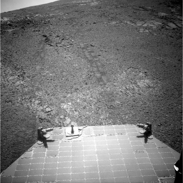
This image from the navigation camera (Navcam) on the mast of NASA's Mars Exploration Rover Opportunity provides a look back to the crest of Endeavour Crater's rim after the rover began descending "Perseverance Valley" on the rim's inner slope. The Navcam took this image on July 18, 2017, during the 4,793rd Martian day, or sol, of Opportunity's work on Mars. Wheel tracks from the top of the rim to the rover are visible above the rear solar panel of the vehicle. For scale, the distance between tracks from right-side wheels and tracks from left-side wheels is about 3.3 feet (1 meter). The knob-topped cylinder mounted at the edge of the solar panel is the calibration target for Opportunity's panoramic camera (Pancam). Opportunity's location on Sol 4793 was a site within the upper end of Perseverance Valley that the rover reached with a drive of about 45 feet (13.8 meters) on July 7 (Sol 4782). The rover team chose this location for Opportunity to spend about three weeks during a driving moratorium for the Mars solar conjunction period. Mars solar conjunction occurs once about every 26 months when Mars passes nearly behind the sun, from Earth's perspective. The relative positions of the three bodies makes radio transmission of commands from Earth to Mars unreliable. One advantage of this chosen location for Opportunity is a slight northward tilt for the solar panels, which adds to their power output during these weeks of southern-hemisphere autumn when daily sunshine is diminishing. https://photojournal.jpl.nasa.gov/catalog/PIA21725
This late-afternoon view from the front Hazard Avoidance Camera on NASA's Mars Exploration Rover Opportunity shows a pattern of rock stripes on the ground, a surprise to scientists on the rover team. Approaching the 5,000th Martian day or sol, of what was planned as a 90-sol mission, Opportunity is still providing new discoveries. This image was taken inside "Perseverance Valley," on the inboard slope of the western rim of Endeavour Crater, on Sol 4958 (Jan. 4, 2018). Both this view and one taken the same sol by the rover's Navigation Camera look downhill toward the northeast from about one-third of the way down the valley, which extends about the length of two football fields from the crest of the rim toward the crater floor. The lighting, with the Sun at a low angle, emphasizes the ground texture, shaped into stripes defined by rock fragments. The stripes are aligned with the downhill direction. The rock to the upper right of the rover's robotic arm is about 2 inches (5 centimeters) wide and about 3 feet (1 meter) from the centerline of the rover's two front wheels. This striped pattern resembles features seen on Earth, including on Hawaii's Mauna Kea, that are formed by cycles of freezing and thawing of ground moistened by melting ice or snow. There, fine-grained fraction of the soil expands as it freezes, and this lifts the rock fragments up and to the sides. If such a process formed this pattern in Perseverance Valley, those conditions might have been present locally during a period within the past few million years when Mars' spin axis was at a greater tilt than it is now, and some of the water ice now at the poles was redistributed to lower latitudes. Other hypotheses for how these features formed are also under consideration, including high-velocity slope winds. https://photojournal.jpl.nasa.gov/catalog/PIA22218
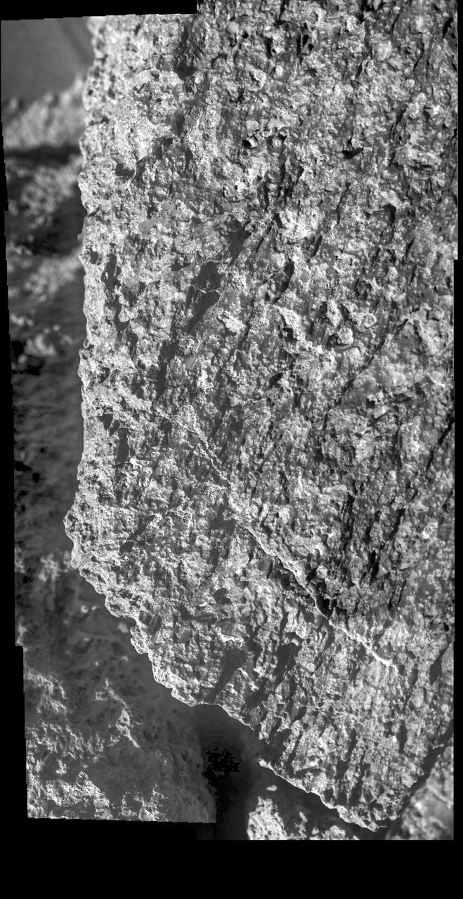
NASA's Opportunity rover used its Microscopic Imager to take a picture of this rock nicknamed "Jornada del Muerto" while in Perseverance Valley. The wind-carved streaks along its face were very similar to rocks seen at the rim of Endeavour Crater earlier in Opportunity's mission. This scene is about 2 inches (5 centimeters) wide. "Jornada del Muerto" (roughly translated: "Dead Man's Journey") was one of the stops along the El Camino Real route used for centuries by Spanish and Mexican colonists to reach New Mexico from Mexico, and used by the Opportunity team to name rocks and features in Perseverance Valley. https://photojournal.jpl.nasa.gov/catalog/PIA23245
NASA's Mars Exploration Rover Opportunity took the component images of this enhanced-color scene during the mission's "walkabout" survey of an area just above the top of "Perseverance Valley," in preparation for driving down the valley. The location is just outside the crest line of the western rim of Endeavour Crater, looking toward the northwest. The rim crest at the top of Perseverance Valley is off the scene to the right. A swath across the top half of the image is lined with dark rocks, especially on the far side. The swath runs east-west, and one possible history under investigation is that it was a channel into a lake perched against the edge of the crater billions of years ago. Another hypothesis is that the linear pattern of the rock piles is related to radial fractures from the impact that excavated Endeavour Crater. One goal of the walkabout is to determine whether a close look at the rocks will provide clues to the history of the site. For scale, the width of the swath near the center of the image is roughly 30 feet (9 meters). Opportunity's panoramic camera (Pancam) recorded this scene on June 3, 2017, during the 4,749th Martian day, or sol, of the rover's work on Mars. The enhanced color helps make differences in surface materials visible. The view merges exposures taken through three of the Pancam's color filters, centered on wavelengths of 753 nanometers (near-infrared), 535 nanometers (green) and 432 nanometers (violet). https://photojournal.jpl.nasa.gov/catalog/PIA21711
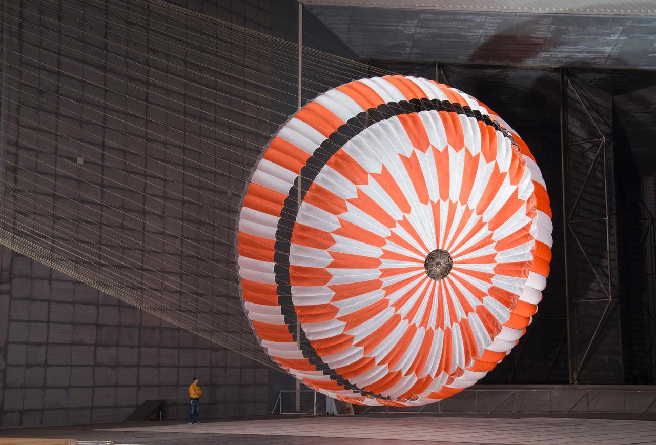
In this June 2017 photo, the supersonic parachute design that will land NASA's Perseverance rover on Mars on Feb. 18, 2021, undergoes testing in a wind tunnel at NASA's Ames Research Center in California's Silicon Valley. https://photojournal.jpl.nasa.gov/catalog/PIA23916
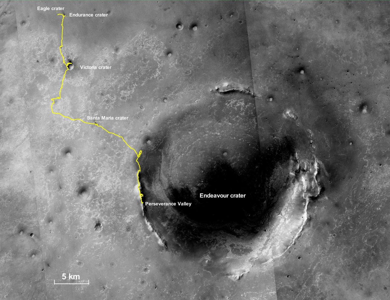
This final traverse map for NASA's Opportunity rover shows where the rover was located within Perseverance Valley on June 10, 2018, the last date it made contact with its engineering team. Visible in this map is a yellow traverse route beginning at Opportunity's landing site, Eagle Crater, and ranging 28.06 miles (45.16 kilometers) to its final resting spot on the rim of Endeavour Crater. The rover was descending down into the crater in Perseverance Valley when the dust storm ended its mission. This map is made from several images taken by the Context Camera on NASA's Mars Reconnaissance Orbiter. Those images are: B02_010486_1779_XN_02S005W, P15_006847_1770_XN_03S005W, and P13_006135_1789_XN_01S005W. Malin Space Science Systems in San Diego built and operates the camera. https://photojournal.jpl.nasa.gov/catalog/PIA23178
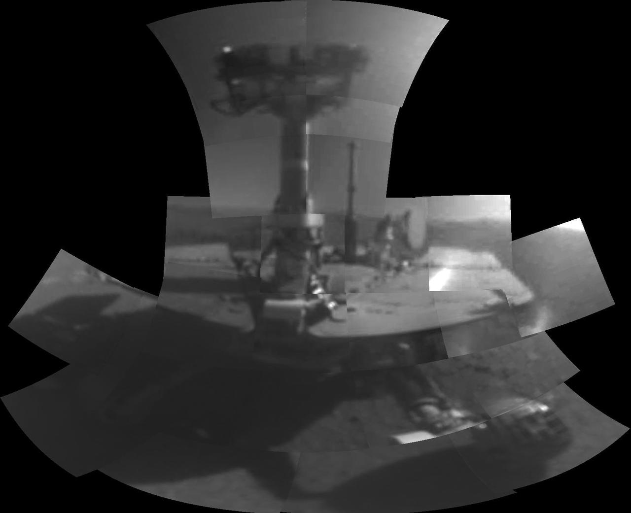
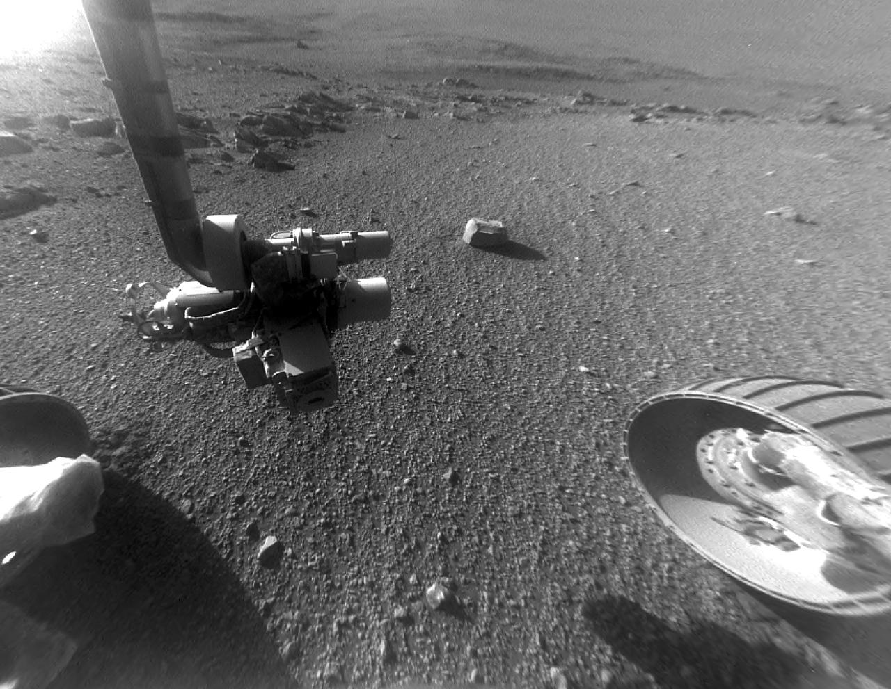
This self-portrait of NASA's Opportunity Mars rover shows the vehicle at a site called "Perseverance Valley" on the slopes of Endeavour Crater. It was taken with the rover's Microscopic Imager to celebrate the 5000th Martian Day, or sol, of the rover's mission. The Microscopic Imager is a fixed-focus camera mounted at the end of the rover's robotic arm. Because it was designed for close inspection of rocks, soils and other targets at a distance of around 2.7 inches (7 cm), the rover is out of focus. The rover's self-portrait view is made by stitching together multiple images take on Sol 5,000 and 5,006 of the mission. Wrist motions and turret rotations on the arm allowed the Microscopic Imager to acquire the mosaic's component images. The resulting mosaic does not include the rover's arm. This simulation from planning software used to write commands for the rover shows the motion of the robotic arm, and an inset view of the Microscopic Imager. https://photojournal.jpl.nasa.gov/catalog/PIA22222
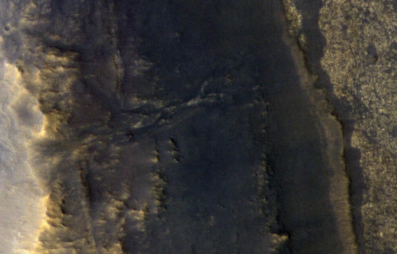
This image taken by NASA's Opportunity rover's HiRISE, a high-resolution camera onboard Mars Reconnaissance Orbiter, shows the dust storm over Perseverance Valley has substantially cleared. Opportunity appears as a blip in this image taken on Thursday, September 20, 2018, from about 166 miles (268 kilometers) above the surface. More information is available at https://photojournal.jpl.nasa.gov/catalog/PIA22549
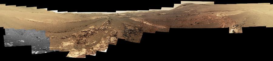
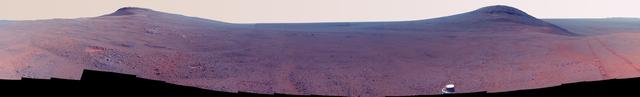
This 360-degree panorama is composed of 354 images taken by the Opportunity rover's Panoramic Camera (Pancam) from May 13 through June 10, 2018, or sols (Martian days) 5,084 through 5,111. This is the last panorama Opportunity acquired before the solar-powered rover succumbed to a global Martian dust storm on the same June 10. This version of the scene is presented in approximate true color. To the right of center and near the top of the frame, the rim of Endeavour Crater rises in the distance. Just to the left of that, rover tracks begin their descent from over the horizon towards the location that would become Opportunity's final resting spot in Perseverance Valley, where the panorama was taken. At the bottom, just left of center, is the rocky outcrop Opportunity was investigating with the instruments on its robotic arm. To the right of center and halfway down the frame is another rocky outcrop - about 23 feet (7 meters) distant from the camera - called "Ysleta del Sur," which Opportunity investigated from March 3 through 29, 2018, or sols 5,015 through 5,038. In the far right and left of the frame are the bottom of Perseverance Valley and the floor of Endeavour Crater. Located on the inner slope of the western rim of Endeavour Crater, Perseverance Valley is a system of shallow troughs descending eastward about the length of two football fields from the crest of Endeavour's rim to its floor. This true-color version combines images collected through three Pancam filters. The filters admit light centered on wavelengths of 753 nanometers (near-infrared), 535 nanometers (green) and 432 nanometers (blue). The three-color bands are combined. A few frames (bottom left) remain black and white, as the solar-powered rover did not have the time to photograph those locations using the green and violet filters before a severe Mars-wide dust storm swept in on June 2018. https://photojournal.jpl.nasa.gov/catalog/PIA22909

This 360-degree panorama is composed of 354 images taken by the Opportunity rover's Panoramic Camera (Pancam) from May 13 through June 10, 2018, or sols (Martian days) 5,084 through 5,111. This is the last panorama Opportunity acquired before the solar-powered rover succumbed to a global Martian dust storm on the same June 10. The view is presented in false color to make some differences between materials easier to see. To the right of center and near the top of the frame, the rim of Endeavour Crater rises in the distance. Just to the left of that, rover tracks begin their descent from over the horizon towards the location that would become Opportunity's final resting spot in Perseverance Valley, where the panorama was taken. At the bottom, just left of center, is the rocky outcrop Opportunity was investigating with the instruments on its robotic arm. To the right of center and halfway down the frame is another rocky outcrop - about 23 feet (7 meters) distant from the camera - called "Ysleta del Sur," which Opportunity investigated from March 3 through 29, 2018, or sols 5,015 through 5,038. In the far right and left of the frame are the bottom of Perseverance Valley and the floor of Endeavour Crater. Located on the inner slope of the western rim of Endeavour Crater, Perseverance Valley is a system of shallow troughs descending eastward about the length of two football fields from the crest of Endeavour's rim to its floor. This view combines images collected through three Pancam filters. The filters admit light centered on wavelengths of 753 nanometers (near-infrared), 535 nanometers (green) and 432 nanometers (blue). The three-color bands are combined. A few frames (bottom left) remain black and white, as the solar-powered rover did not have the time to photograph those locations using the green and violet filters before a severe Mars-wide dust storm swept in on June 2018. https://photojournal.jpl.nasa.gov/catalog/PIA22908
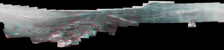
This image is a shortened version of a 360-degree panorama taken by the Opportunity rover's Panoramic Camera (Pancam) from May 13 through June 10, 2018, or sols (Martian days) 5,084 through 5,111. This is the last panorama Opportunity acquired before the solar-powered rover succumbed to a global Martian dust storm on the same June 10. The panorama appears in 3D when seen through blue-red glasses with the red lens on the left. To the right of center and near the top of the frame, the rim of Endeavour Crater rises in the distance. Just to the left of that, rover tracks begin their descent from over the horizon towards the location that would become Opportunity's final resting spot in Perseverance Valley, where the panorama was taken. At the bottom, just left of center, is the rocky outcrop Opportunity was investigating with the instruments on its robotic arm. To the right of center and halfway down the of the frame is another rocky outcrop about 23 feet (7 meters) distant from the camera called "Ysleta del Sur" that Opportunity investigated from March 3 through 29, 2018, or sols 5,015 through 5,038. In the far right and left of the frame are the bottom of Perseverance Valley and the floor of Endeavour Crater. Located on the inner slope of the western rim of Endeavour Crater, Perseverance Valley is a system of shallow troughs descending eastward about the length of two football fields from the crest of Endeavour's rim to its floor. https://photojournal.jpl.nasa.gov/catalog/PIA22910
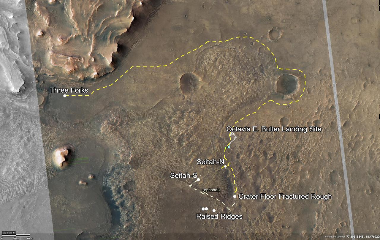
This annotated image of Mars' Jezero Crater depicts the route NASA's Perseverance rover will take during its first science campaign – as well as its path to the location of its second science campaign. The image was provided by the High Resolution Imaging Experiment (HiRISE) aboard NASA's Mars Reconnaissance orbiter. Perseverance's first science campaign sends the rover south and west of the Octavia E. Butler Landing Site to investigate and sample several of the deepest, and potentially oldest, accessible geologic units in Jezero Crater – the "Séítah" unit (which in Navajo language means "amidst the sand"), and the "Cratered Floor Fractured Rough." At the completion of the science campaign, Perseverance will return to the "Octavia E. Butler" landing site on its way north, then head west toward the location where its second science campaign will begin. The first science campaign (depicted with yellow hash marks) begins with the rover performing an arching drive southward from its landing site to Séítah-North (Séítah-N). At that point the rover will travel west a short distance to an overlook where it can view much of the Séítah unit. The "Séítah-N Overlook" could also become an area of scientific interest – with Perseverance performing a "toe dip" into the unit to collect remote-sensing measurements of geologic targets. Once its time at the Séítah-N Overlook is complete, Perseverance will head east, then south toward a spot where the science team can study the Crater Floor Fractured Rough in greater detail. The first core sample collected by the mission will also take place at this location. After Cratered Floor Fractured Rough, the Perseverance rover team will evaluate whether additional exploration (depicted with light-yellow hash marks) farther south – and then west – is warranted. Whether Perseverance travels beyond the Cratered Floor Fractured Rough during this first science campaign, the rover will eventually retrace its steps. As Perseverance passes the Octavia B. Butler landing site, the first science campaign will conclude. At that point, several months of travel lay ahead as Perseverance makes its way to "Three Forks," where the second science campaign will begin. From Three Forks, Perseverance can access geologic locations at the base of the ancient delta (the fan-shaped remains of the confluence of an ancient river and a lake), as well as ascend the delta by driving up a valley wall to the northwest. https://photojournal.jpl.nasa.gov/catalog/PIA24596

A model of NASA's Mars Science Helicopter concept is shown in this photo. This helicopter concept is a more capable proposed follow-on to NASA's Ingenuity Mars Helicopter, which arrived at the Red Planet in the belly of the agency's Perseverance rover in February 2021. The six-rotor Mars Science Helicopter could be used during future Mars missions to serve as an aerial scout, carrying between 4.5 and 11 pounds (2 to 5 kilograms) of payload, including science instruments, and studying terrain that rovers can't reach. It remains in early conceptual and design stages. The proposed design is the product of collaboration between JPL, NASA's Ames Research Center in California's Silicon Valley, and AeroVironment Inc. https://photojournal.jpl.nasa.gov/catalog/PIA25661
Late-afternoon shadows include one cast by the rover itself in this look toward the floor of Endeavour Crater by NASA's Mars Exploration Rover Opportunity. The rover recorded this scene on Nov. 11, 2017, during the 4,911th Martian day, or sol, of the rover's work on Mars. That was about a week before Opportunity's eighth Martian winter solstice. Opportunity's location is partway down a narrow valley that descends from the crest of the western rim of Endeavour Crater to the crater's floor. This fluid-carved set of troughs, called "Perseverance Valley," is the length of about two football fields, at a slope of about 15 to 17 degrees. The Navigation Camera (Navcam) on Opportunity's mast took the three component images stitched together into this scene. The images were taken about three minutes apart, long enough to see how the shadow was changing on the slope, at the seams between the images. Wheel tracks in the lower right of the scene were made before the rover climbed back uphill for a closer look at some rocks it had passed. The portions of the rover in the shadow at upper right include the mast with the Navcam and Panoramic Camera (Pancam) on top and the UHF radio antenna, which Opportunity uses to transmit images and other data to overflying orbiters for relay to Earth. https://photojournal.jpl.nasa.gov/catalog/PIA22071
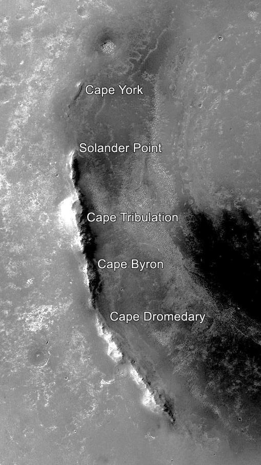
This orbital image of the western rim of Mars' Endeavour Crater covers an area about 5 miles (8 kilometers) east-west by about 9 miles (14 kilometers) north-south and indicates the names of some of the raised segments of the rim. NASA's Mars Exploration Rover Opportunity arrived at Endeavour in 2011 after exploring smaller craters to the northwest during its first six years on Mars. It initially explored the "Cape York" segment, then headed south. It reached the northern end of "Cape Tribulation" in late 2014 and the southern tip of that segment in April 2017. A key destination in the "Cape Byron" segment is "Perseverance Valley," where the rover team plans to investigate whether the valley was carved by water, wind or a debris flow initiated by water. This image is from the Context Camera on NASA's Mars Reconnaissance Orbiter. Malin Space Science Systems, San Diego, California, built and operates that camera. NASA's Jet Propulsion Laboratory, a division of Caltech in Pasadena, California, built and operates Opportunity. https://photojournal.jpl.nasa.gov/catalog/PIA21490
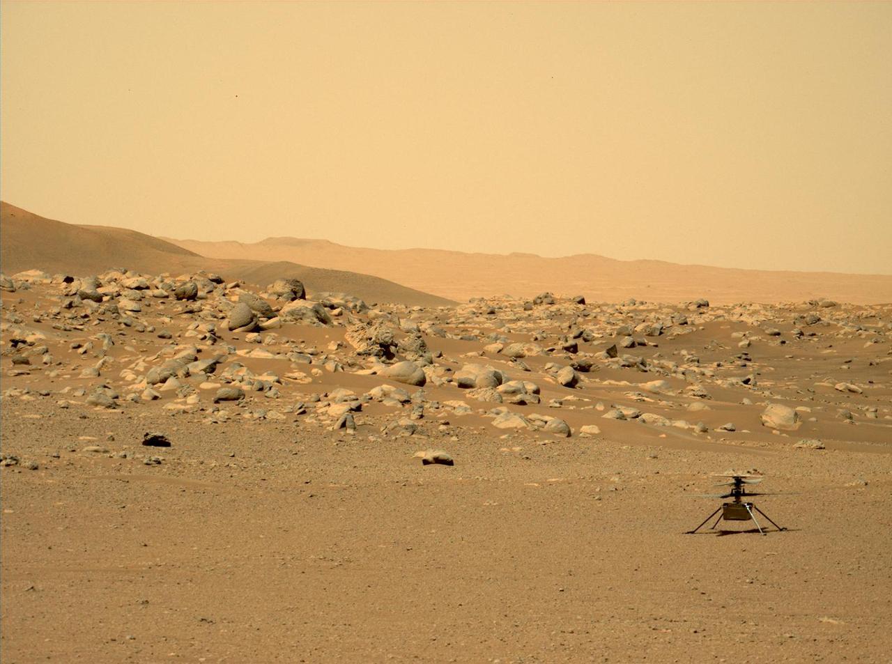
This image of NASA's Ingenuity Mars Helicopter was taken by the Mastcam-Z instrument of the Perseverance rover on June 15, 2021, the 114th Martian day, or sol, of the mission. The location, "Airfield D" (the fourth airfield), is just east of the "Séítah" geologic unit. The image has been processed from the original version. Ingenuity was built by NASA's Jet Propulsion Laboratory in Southern California, which also manages the project for NASA Headquarters. It is supported by NASA's Science Mission Directorate. NASA's Ames Research Center in California's Silicon Valley, and NASA's Langley Research Center in Hampton, Virginia, provided significant flight performance analysis and technical assistance during Ingenuity's development. AeroVironment Inc., Qualcomm, and SolAero also provided design assistance and major vehicle components. Lockheed Martin Space designed and manufactured the Mars Helicopter Delivery System. A key objective for Perseverance's mission on Mars is astrobiology, including the search for signs of ancient microbial life. The rover will characterize the planet's geology and past climate, pave the way for human exploration of the Red Planet, and be the first mission to collect and cache Martian rock and regolith (broken rock and dust). Subsequent NASA missions, in cooperation with ESA (European Space Agency), would send spacecraft to Mars to collect these sealed samples from the surface and return them to Earth for in-depth analysis. https://photojournal.jpl.nasa.gov/catalog/PIA25213
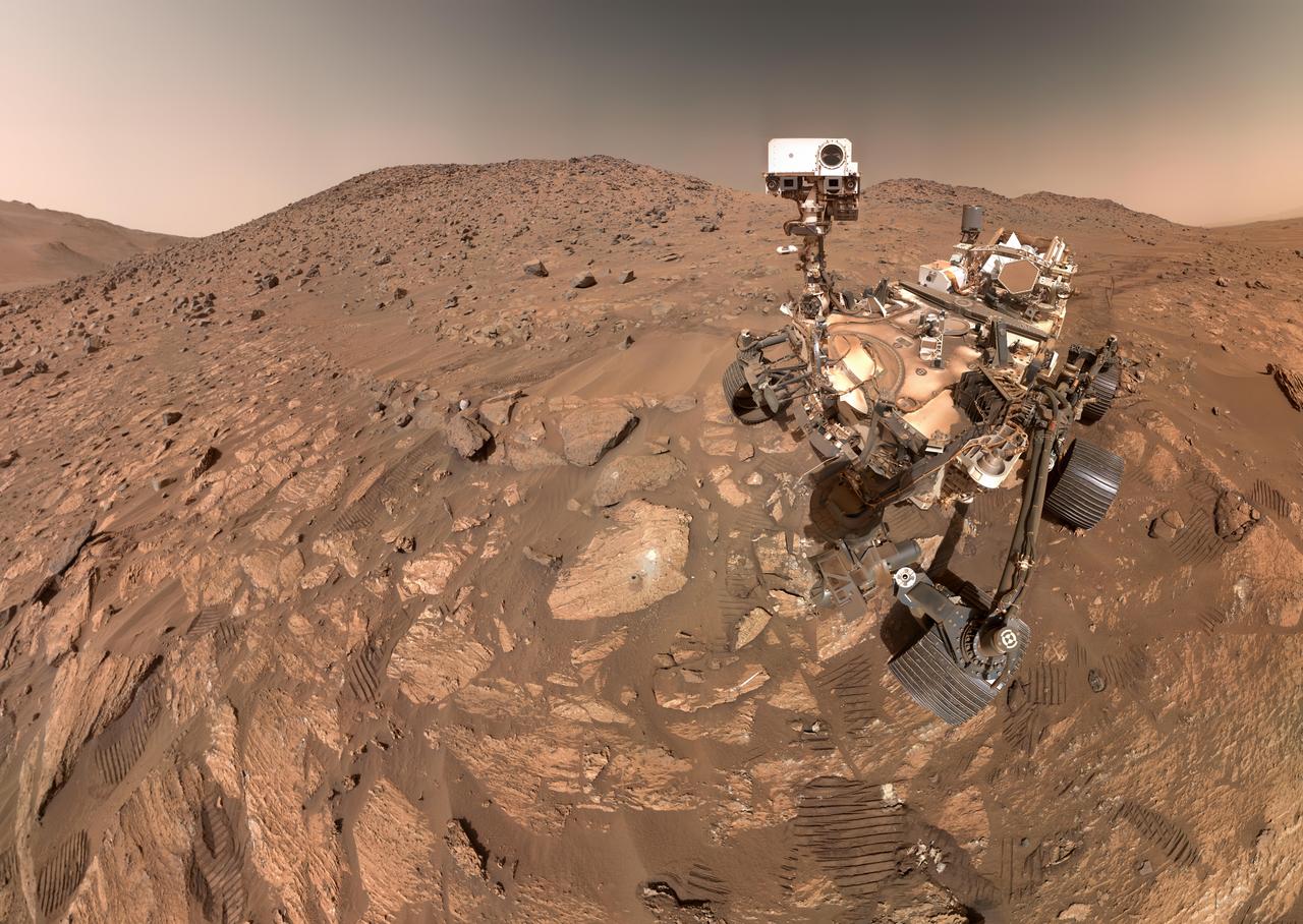
NASA's Perseverance Mars rover took this selfie on July 23, 2024, the 1,218th Martian day, or sol, of the mission. To the left of the rover near the center of the image is the arrowhead-shaped rock nicknamed "Cheyava Falls," which has features that may bear on the question of whether Mars was home to microscopic life in the distant past. The small dark hole in the rock is where Perseverance took a core sample, which is now in a sample tube stored in the rover's belly. The white patch to the right of the hole is where the rover used an abrasion tool to clear away the top surface, allowing science instruments to study the rock's composition. Measuring 3.2 feet by 2 feet (1 meter by 0.6 meters) and named after a Grand Canyon waterfall, Cheyava Falls lies at the northern edge of Neretva Vallis, an ancient river valley measuring a quarter-mile (400 meters) wide that was carved by water rushing into Jezero Crater long ago. The selfie is composed of 62 images taken by the WATSON (Wide Angle Topographic Sensor for Operations and eNgineering) camera on the end of the rover's robotic arm. The images were stitched together after being sent back to Earth. Animation available at https://photojournal.jpl.nasa.gov/catalog/PIA26344
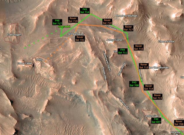
This animation shows the progress of NASA's Perseverance Mars rover and its Ingenuity Mars Helicopter as they make the climb up Jezero Crater's delta toward ancient river deposits. The helicopter's route is depicted in green, while the rover's progress is shown in orange. Black labels indicate which day, or sol, of the mission the rover and helicopter were on at each point. (Martian sols are counted from the date the Perseverance rover landed on Mars, Feb. 18, 2021). For the helicopter, the black labels also indicate which flight is shown; depicted here are Ingenuity's 42nd (F42) to 46th (F46) sorties. The Ingenuity Mars Helicopter was built by NASA's Jet Propulsion Laboratory in Southern California, which also manages the project for NASA Headquarters. It is supported by NASA's Science Mission Directorate. NASA's Ames Research Center in California's Silicon Valley, and NASA's Langley Research Center in Hampton, Virginia, provided significant flight performance analysis and technical assistance during Ingenuity’s development. AeroVironment Inc., Qualcomm, and SolAero also provided design assistance and major vehicle components. Lockheed Martin Space designed and manufactured the Mars Helicopter Delivery System. A key objective for Perseverance's mission on Mars is astrobiology, including the search for signs of ancient microbial life. The rover will characterize the planet's geology and past climate, pave the way for human exploration of the Red Planet, and be the first mission to collect and cache Martian rock and regolith (broken rock and dust). Subsequent NASA missions, in cooperation with ESA (European Space Agency), would send spacecraft to Mars to collect these sealed samples from the surface and return them to Earth for in-depth analysis. The Mars 2020 Perseverance mission is part of NASA's Moon to Mars exploration approach, which includes Artemis missions to the Moon that will help prepare for human exploration of the Red Planet. Animation available at https://photojournal.jpl.nasa.gov/catalog/PIA25687
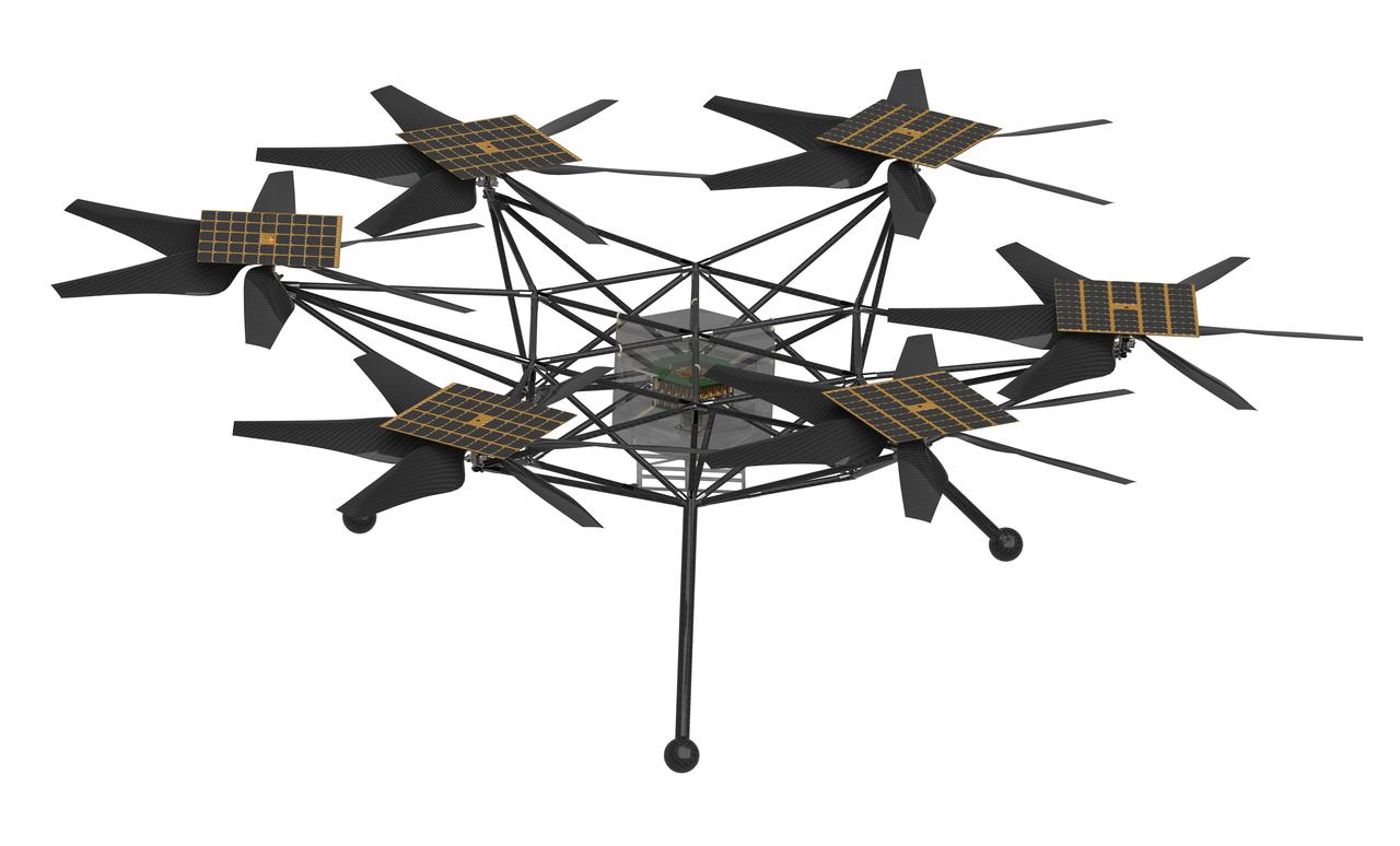
NASA's Mars Chopper concept, shown in a design software rendering, is a more capable proposed follow-on to the agency's Ingenuity Mars Helicopter, which arrived at the Red Planet in the belly of the Perseverance rover in February 2021. Chopper would be about the size of an SUV, with six rotors, each with six blades. It could be used to carry science payloads as large as 11 pounds (5 kilograms) distances of up to 1.9 miles (3 kilometers) each Martian day (or sol). Scientists could use Chopper to study large swaths of terrain in detail, quickly – including areas where rovers cannot safely travel. Chopper remains in early conceptual and design stages. The proposed design is the product of collaboration between NASA's Jet Propulsion Laboratory in Southern California, the agency's Ames Research Center in California's Silicon Valley, and AeroVironment Inc. https://photojournal.jpl.nasa.gov/catalog/PIA26375
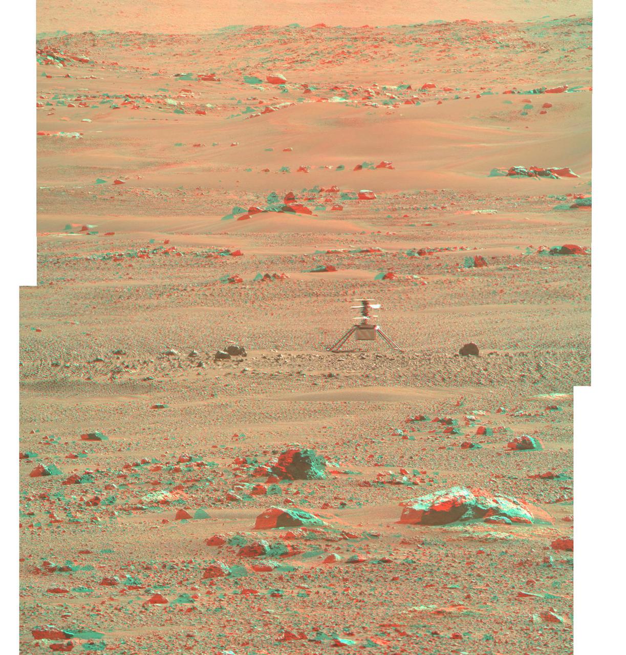
NASA's Ingenuity Mars Helicopter is seen here in 3D using images taken June 6, 2021 (the 105 the Martian day, or sol, of the mission), by the left and right Mastcam-Z cameras aboard NASA's Perseverance Mars rover. The Ingenuity Mars Helicopter was built by JPL, which also manages the technology demonstration project for NASA Headquarters. It is supported by NASA's Science, Aeronautics Research, and Space Technology mission directorates. NASA's Ames Research Center in California's Silicon Valley, and NASA's Langley Research Center in Hampton, Virginia, provided significant flight performance analysis and technical assistance during Ingenuity's development. AeroVironment Inc., Qualcomm, and SolAero also provided design assistance and major vehicle components. Lockheed Martin Space designed and manufactured the Mars Helicopter Delivery System. A key objective for Perseverance's mission on Mars is astrobiology, including the search for signs of ancient microbial life. The rover will characterize the planet's geology and past climate, pave the way for human exploration of the Red Planet, and be the first mission to collect and cache Martian rock and regolith (broken rock and dust). Subsequent NASA missions, in cooperation with ESA (European Space Agency), would send spacecraft to Mars to collect these sealed samples from the surface and return them to Earth for in-depth analysis. The Mars 2020 Perseverance mission is part of NASA's Moon to Mars exploration approach, which includes Artemis missions to the Moon that will help prepare for human exploration of the Red Planet. https://photojournal.jpl.nasa.gov/catalog/PIA24670
NASA's Mars Exploration Rover Opportunity worked for 30 months on a raised segment of Endeavour Crater's rim called "Cape Tribulation" until departing that segment in mid-April 2017, southbound toward a new destination. This view looks back at the southern end of Cape Tribulation from about two football fields' distance away. The component images were taken by the rover's Panoramic Camera (Pancam) on April 21, during the 4,707th Martian day, or sol, of Opportunity's mission on Mars. Wheel tracks can be traced back to see the rover's route as it descended and departed Cape Tribulation. For scale, the distance between the two parallel tracks is about 3.3 feet (1 meter). The rover drove from the foot of Cape Tribulation to the head of "Perseverance Valley" in seven drives totaling about one-fifth of a mile (one-third of a kilometer). The elevation difference between the highest point visible in this scene and the rover's location when the images were taken is about 180 feet (55 meters). This view looks northward. It merges exposures taken through three of the Pancam's color filters, centered on wavelengths of 753 nanometers (near-infrared), 535 nanometers (green) and 432 nanometers (violet). It is presented in approximately true color. https://photojournal.jpl.nasa.gov/catalog/PIA21497

NASA's Mars Exploration Rover Opportunity worked for 30 months on a raised segment of Endeavour Crater's rim called "Cape Tribulation" until departing that segment in mid-April 2017, southbound toward a new destination. This view looks back at the southern end of Cape Tribulation from about two football fields' distance away. In this version of the scene the landscape is presented in enhanced color to make differences in surface materials more easily visible. The component images were taken by the rover's Panoramic Camera (Pancam) on April 21, during the 4,707th Martian day, or sol, of Opportunity's mission on Mars. Wheel tracks can be traced back to see the rover's route as it descended and departed Cape Tribulation. For scale, the distance between the two parallel tracks is about 3.3 feet (1 meter). The rover drove from the foot of Cape Tribulation to the head of "Perseverance Valley" in seven drives totaling about one-fifth of a mile (one-third of a kilometer). The elevation difference between the highest point visible in this scene and the rover's location when the images were taken is about 180 feet (55 meters). This view looks northward. It merges exposures taken through three of the Pancam's color filters, centered on wavelengths of 753 nanometers (near-infrared), 535 nanometers (green) and 432 nanometers (violet). https://photojournal.jpl.nasa.gov/catalog/PIA21498
NASA's Perseverance Mars rover captured this mosaic showing the Ingenuity Mars Helicopter at its final airfield on Feb. 4, 2024. The helicopter damaged its rotor blades during landing on its 72nd flight on Jan. 18, 2024. The Ingenuity team has nicknamed the spot where the helicopter completed its final flight "Valinor Hills" after the fictional location in J.R.R. Tolkien's fantasy novels, which include "The Lord of the Rings" trilogy. The six images that were stitched together to make up this mosaic were captured from about 1,475 feet (450 meters) away by the rover's Mastcam-Z imager. Shown here is an enhanced-color view that exaggerates subtle color differences in the scene to show more detail. The Ingenuity Mars Helicopter was built by NASA's Jet Propulsion Laboratory, which manages the project for NASA Headquarters. It is supported by NASA's Science Mission Directorate. NASA's Ames Research Center in California's Silicon Valley and NASA's Langley Research Center in Hampton, Virginia, provided significant flight performance analysis and technical assistance during Ingenuity's development. AeroVironment Inc., Qualcomm, and SolAero also provided design assistance and major vehicle components. Lockheed Martin Space designed and manufactured the Mars Helicopter Delivery System. Arizona State University leads the operations of the Mastcam-Z instrument, working in collaboration with Malin Space Science Systems in San Diego, on the design, fabrication, testing, and operation of the cameras, and in collaboration with the Niels Bohr Institute of the University of Copenhagen on the design, fabrication, and testing of the calibration targets. A key objective for Perseverance's mission on Mars is astrobiology, including the search for signs of ancient microbial life. The rover will characterize the planet's geology and past climate, pave the way for human exploration of the Red Planet, and be the first mission to collect and cache Martian rock and regolith (broken rock and dust). Subsequent NASA missions, in cooperation with ESA (European Space Agency), would send spacecraft to Mars to collect these sealed samples from the surface and return them to Earth for in-depth analysis. The Mars 2020 Perseverance mission is part of NASA's Moon to Mars exploration approach, which includes Artemis missions to the Moon that will help prepare for human exploration of the Red Planet. https://photojournal.jpl.nasa.gov/catalog/PIA26236

Taken on June 10, 2018 (the 5,111th Martian day, or sol, of the mission) this "noisy", incomplete image was the last data NASA's Opportunity rover sent back from Perseverance Valley on Mars. The partial, full-frame image from the Panoramic Camera (Pancam) was sent up to NASA's Mars Reconnaissance Orbiter around 9:45 a.m. PDT (12:45 p.m. EDT) to relay back to Earth as an intense dust storm darkened the skies around the solar-powered rover. The image was received on Earth at around 10:05 a.m. PDT (1:05 p.m. EDT). Opportunity took this image with the left eye of the Pancam, with its solar filter pointed at the Sun. But since the dust storm blotted out the Sun, the image is dark. The white speckles are noise from the camera. All Pancam images have noise in them, but the darkness makes it more apparent. The transmission stopped before the full image was transmitted, leaving the bottom of the image incomplete, represented here as black pixels. While this partial full-frame image was the last that Opportunity transmitted, it was not actually the last set of images from Opportunity. This image was taken at around 9:30 a.m. PDT (12:30 p.m. EDT) on June 10, 2018. Another set of images (PIA22930) was taken about three minutes later. The thumbnail versions of the last images taken were transmitted, but the rover lost contact before transmitting the full-frame versions. https://photojournal.jpl.nasa.gov/catalog/PIA22929

These two thumbnail images, with the ghostly dot of a faint Sun near the middle of each, are the last images NASA's Opportunity rover took on Mars as a dust storm darkened the sky. These images from the left and right eyes of the Panoramic Camera (Pancam) were used to estimate how opaque the atmosphere was (a measurement known as "tau") on Opportunity's final day of operation. With a tau of about 10.8 on that day, scientists knew that only a tiny amount of sunlight was getting through the dust. The left and right Pancam eyes had camera filters that typically help with geological investigations: 440-nanometer (deep blue) and 750-nanometer (red to infrared) filters, respectively. These filters would normally result in overexposed images, but with such weak sunlight, scientists were able to point the Pancams at the Sun and determine the tau. The left Pancam image (Figure 1) has more wavy gradations. In the right Pancam image (Figure 2), the Sun appears as the larger whitish feature in the middle of the frame. These images were taken in Perseverance Valley around 9:33 a.m. PDT (12:33 a.m. EDT) on June 10, 2018 (the 5,111st Martian day, or sol, of Opportunity's mission). These thumbnails were not the last images transmitted by the rover: The last image sent (PIA22929) is a partial full-frame image of a dark sky. While full-frame image versions are typically sent after thumbnails, the full-frame versions of these images with faint spots of sun were never transmitted. https://photojournal.jpl.nasa.gov/catalog/PIA22930