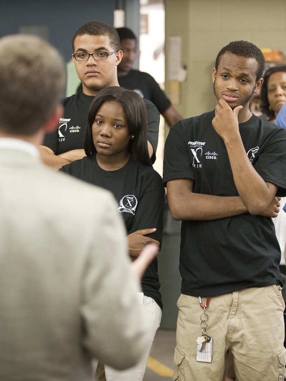
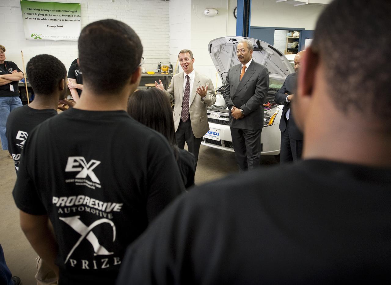
NASA Chief Technologist Bobby Braun talks with student members of the West Philly Hybrid X Team at West Philadelphia High School in Philadelphia, Monday, June 7, 2010. The prize-winning West Philly Hybrid X Team has drawn international recognition as the only high school among 22 finalists in the Progressive Insurance Automotive X Prize (PIAXP) competition to develop cars that achieve over 100 MPG. Photo Credit: (NASA/Bill Ingalls)
NASA Chief Technologist Bobby Braun talks with student members of the West Philly Hybrid X Team at West Philadelphia High School in Philadelphia, Monday, June 7, 2010. The prize-winning West Philly Hybrid X Team has drawn international recognition as the only high school among 22 finalists in the Progressive Insurance Automotive X Prize (PIAXP) competition to develop cars that achieve over 100 MPG. Photo Credit: (NASA/Bill Ingalls)

NASA Chief Technologist Bobby Braun talks with student members of the West Philly Hybrid X Team at West Philadelphia High School in Philadelphia, Monday, June 7, 2010. The prize-winning West Philly Hybrid X Team has drawn international recognition as the only high school among 22 finalists in the Progressive Insurance Automotive X Prize (PIAXP) competition to develop cars that achieve over 100 MPG. Photo Credit: (NASA/Bill Ingalls)
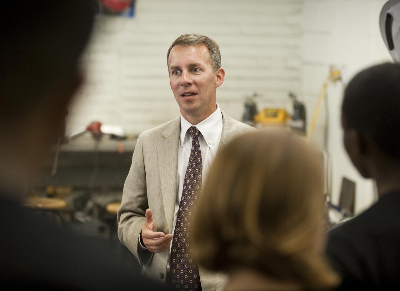
NASA Chief Technologist Bobby Braun, left, and Pennsylvania State Representative Jim Roebuck talk with students of the West Philly Hybrid X Team at West Philadelphia High School in Philadelphia, Monday, June 7, 2010. The prize-winning West Philly Hybrid X Team has drawn international recognition as the only high school among 22 finalists in the Progressive Insurance Automotive X Prize (PIAXP) competition to develop cars that achieve over 100 MPG. Photo Credit: (NASA/Bill Ingalls)

NASA Chief Technologist Bobby Braun talks with student members of the West Philly Hybrid X Team at West Philadelphia High School in Philadelphia, Monday, June 7, 2010. The prize-winning West Philly Hybrid X Team has drawn international recognition as the only high school among 22 finalists in the Progressive Insurance Automotive X Prize (PIAXP) competition to develop cars that achieve over 100 MPG. Photo Credit: (NASA/Bill Ingalls)
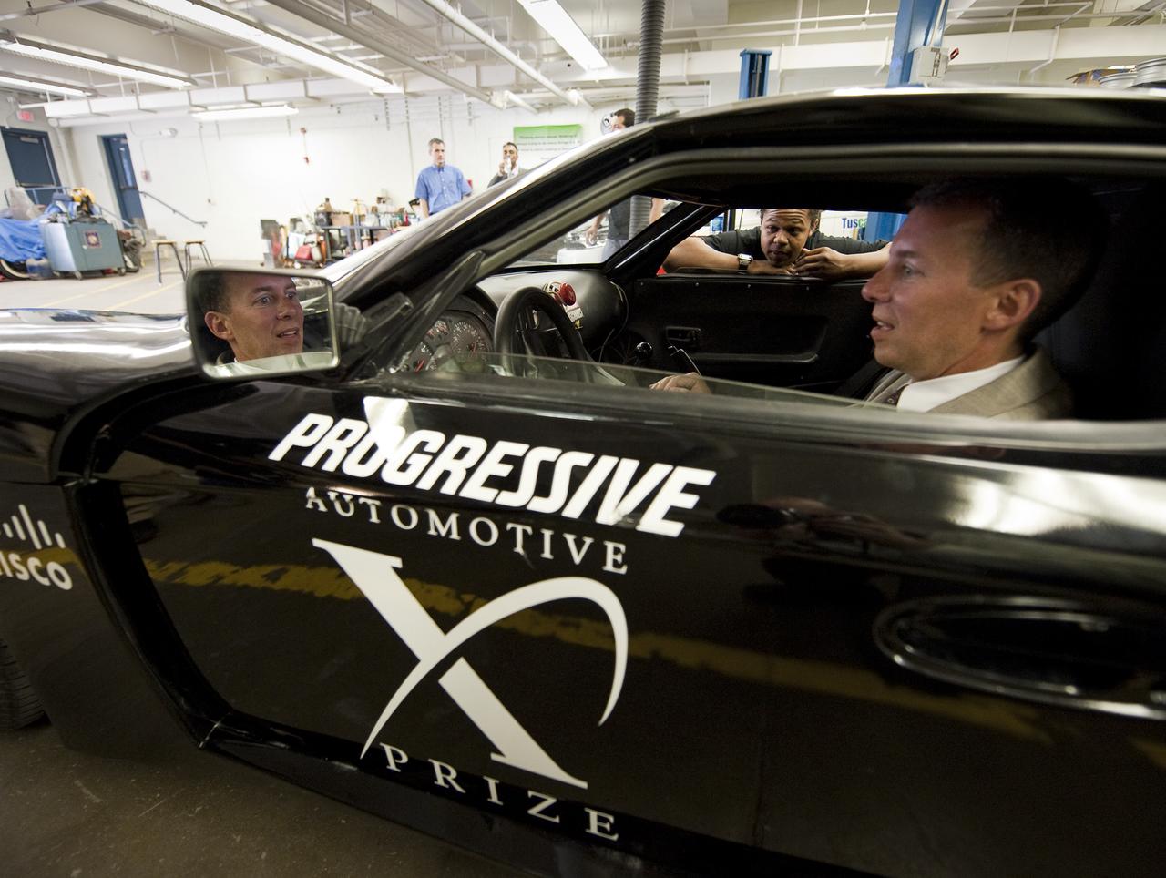
NASA Chief Technologist Bobby Braun sits in the West Philly X Prize hybrid sports car as Sowande Gay, a student member of the West Philly Hybrid Team at West Philadelphia High School, explains the modifications made to the car, in Philadelphia, Monday, June 7, 2010. The prize-winning West Philly Hybrid X Team has drawn international recognition as the only high school among 22 finalists in the Progressive Insurance Automotive X Prize (PIAXP) competition to develop cars that achieve over 100 MPG. Photo Credit: (NASA/Bill Ingalls)
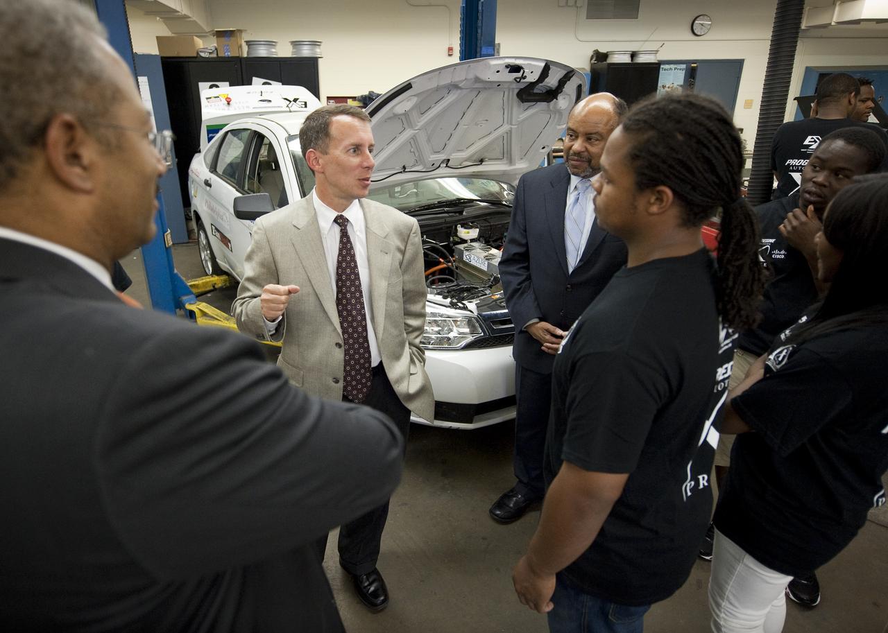
NASA Chief Technologist Bobby Braun, left, and Congressman Chaka Fattah (D-PA), right, talk to student members of the West Philly Hybrid X Team at West Philadelphia High School in Philadelphia, Monday, June 7, 2010. The prize-winning West Philly Hybrid X Team has drawn international recognition as the only high school among 22 finalists in the Progressive Insurance Automotive X Prize (PIAXP) competition to develop cars that achieve over 100 MPG. Photo Credit: (NASA/Bill Ingalls)
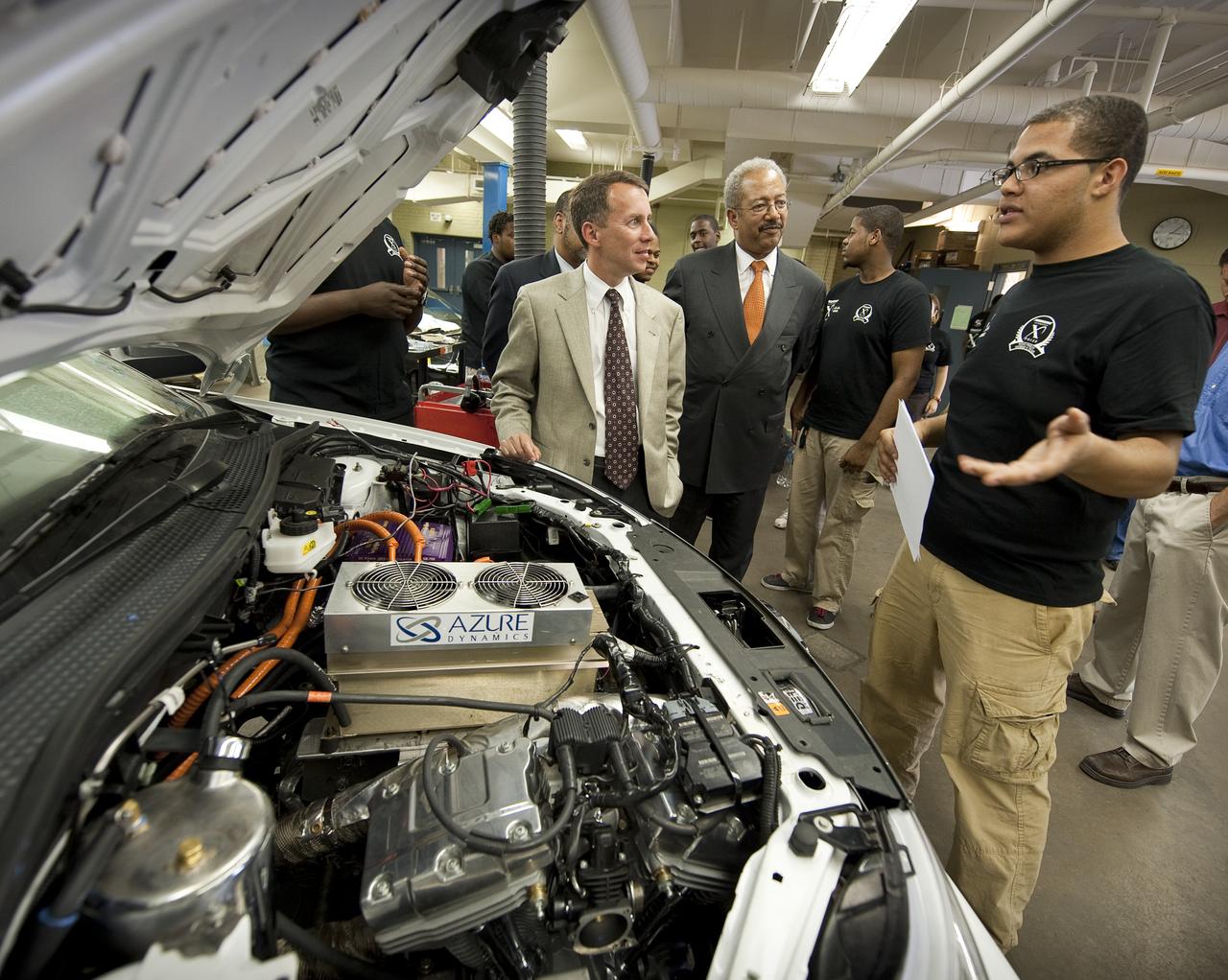
NASA Chief Technologist Bobby Braun, left, and Congressman Chaka Fattah (D-PA), center, listen to Azeem Hill, a member of the West Philly Hybrid X Team at West Philadelphia High School in Philadelphia, Monday, June 7, 2010. The prize-winning West Philly Hybrid X Team has drawn international recognition as the only high school among 22 finalists in the Progressive Insurance Automotive X Prize (PIAXP) competition to develop cars that achieve over 100 MPG. Photo Credit: (NASA/Bill Ingalls)
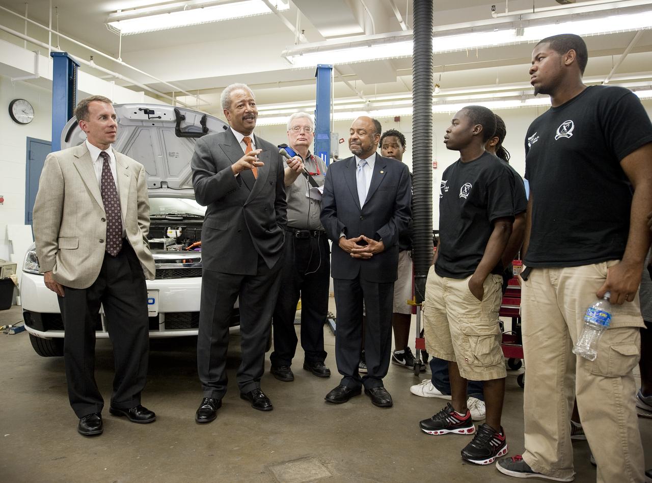
NASA Chief Technologist Bobby Braun, left, and Congressman Chaka Fattah (D-PA), center, and Pennsylvania State Representative Jim Roebuck talk with students of the West Philly Hybrid X Team at West Philadelphia High School in Philadelphia, Monday, June 7, 2010. The prize-winning West Philly Hybrid X Team has drawn international recognition as the only high school among 22 finalists in the Progressive Insurance Automotive X Prize (PIAXP) competition to develop cars that achieve over 100 MPG. Photo Credit: (NASA/Bill Ingalls)
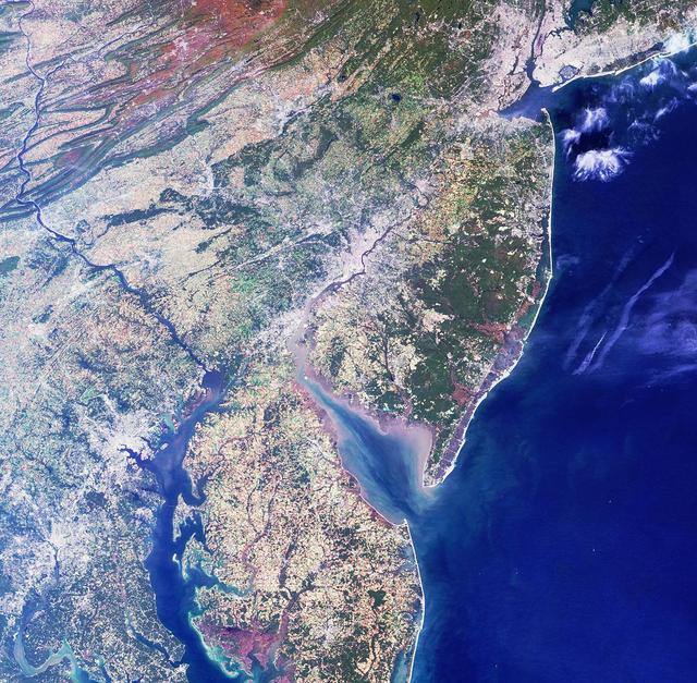
Philadelphia lies in the center of this image from NASA Terra satellite. Larger cities, including New York, Newark, Philadelphia, Wilmington, Baltimore and Washington D.C., are visible from upper right to lower left.
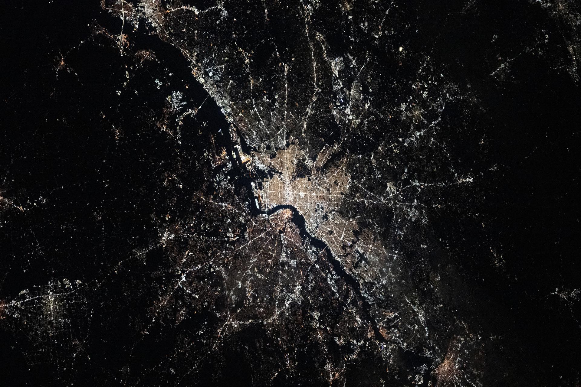
iss074e0002935 (Dec. 20, 2025) --- Philadelphia, Pennsylvania—the United States’ first capital and the city where the Declaration of Independence was signed, with a population of about 1.74 million—sits along the Delaware River, with New Jersey on the opposite bank. This photograph was taken at approximately 3:28 a.m. local time from the International Space Station as it orbited 262 miles above the Atlantic coast.
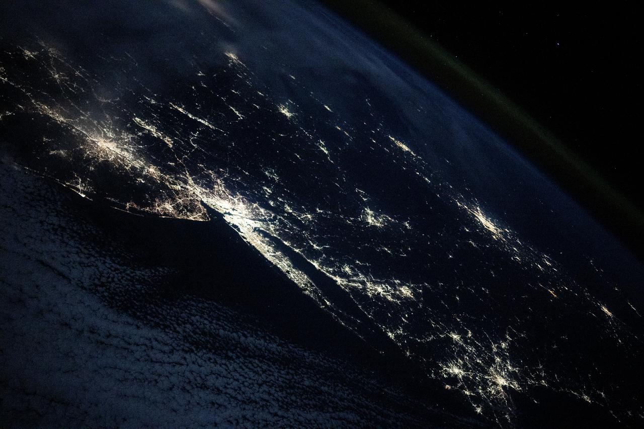
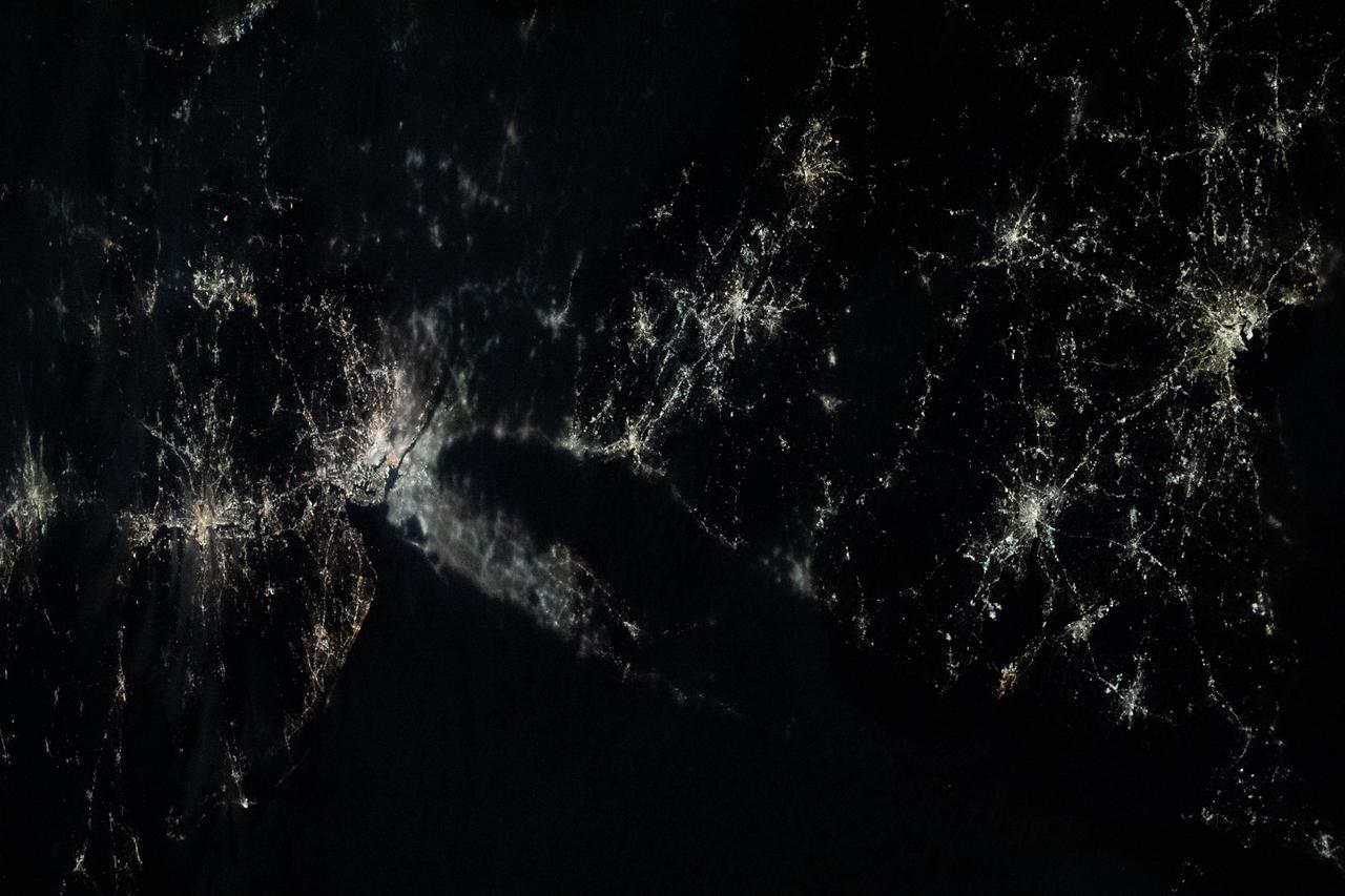
iss072e186819 (Nov. 14, 2024) --- The city lights of the United States' eastern seaboard from Philadelphia, Pennsylvania; to New York City; to Boston, Massachusetts; as well as Montreal, Quebec, in Canada (right center), are pictured from the International Space Station as it orbited 254 miles above the Atlantic Ocean.
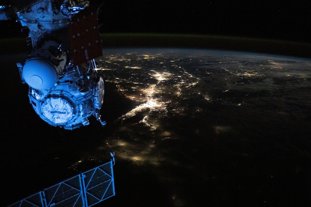
iss070e013946 (Oct. 26, 2023) --- This nighttime view from the International Space Station shows the city lights of the northeastern United States and major urban areas including Long Island, New York; Philadelphia, Pennsylvania; and Washington D.C. The orbital lab was soaring 262 miles above the Pine Tree State of Maine at the time of this photograph.

NASA's Kennedy Space Center in Florida observes U.S. Constitution Day, the official birthday of our U.S. government, with the theme "Freedom Needs Space." A remembrance poster made appearances in various locations around the multi-user spaceport, including at the new Headquarters Campus Building. Constitution Day is an American federal observance. It recognizes the adoption of the U.S. Constitution and those who have become U.S. citizens. Constitution Day is observed on Sept. 17, the day in 1787 that delegates to the Constitutional Convention signed the document in Philadelphia.
ISS030-E-055791 (29 Jan. 2012) --- This Jan. 29 panorama of much of the East Coast, photographed by one of the Expedition 30 crew members aboard the International Space Station, provides a look generally northeastward: Philadelphia-New York City-Boston corridor (bottom-center); western Lake Ontario shoreline with Toronto (left edge); Montreal (near center). An optical illusion in the photo makes the atmospheric limb and light activity from Aurora Borealis appear “intertwined.”
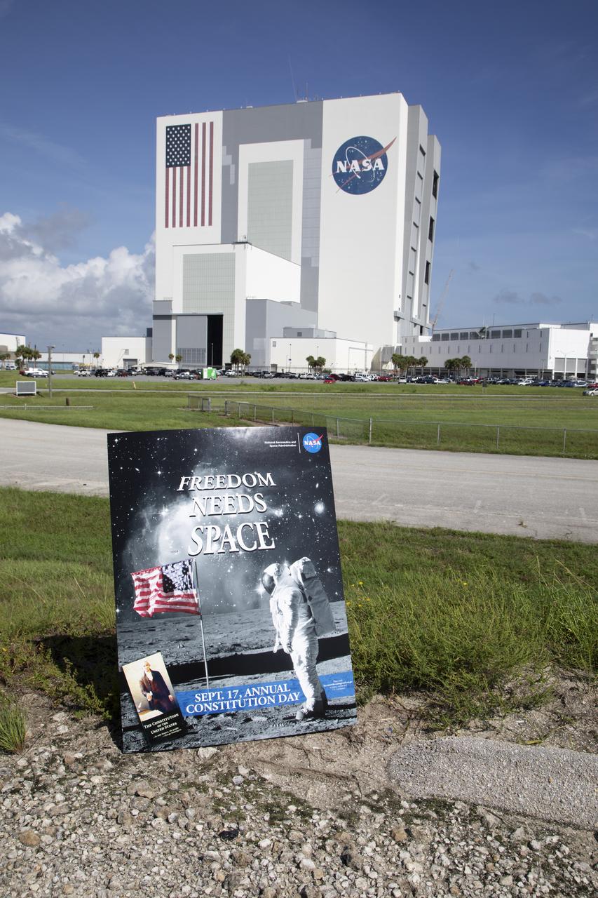
NASA's Kennedy Space Center in Florida observes U.S. Constitution Day, the official birthday of our U.S. government, with the theme "Freedom Needs Space." A remembrance poster made appearances in various locations around the multi-user spaceport, including near the iconic Vehicle Assembly Building. Constitution Day is an American federal observance. It recognizes the adoption of the U.S. Constitution and those who have become U.S. citizens. Constitution Day is observed on Sept. 17, the day in 1787 that delegates to the Constitutional Convention signed the document in Philadelphia.

White House Office of Science and Technology Policy Associate Director for Science Carl Wieman, left, talks with West Philadelphia High School student Brandon Ford, left, and Montana Central Catholic High School student Mikayla Nelson at the New Executive Office Building, Tuesday, Jan. 25, 2011 in Washington. The students are all young achievers in science and technology and will be amongst other guests seated in the First Lady’s Box in the U.S. Capitol during the President’s State of the Union Address. Photo Credit: (NASA/Bill Ingalls)
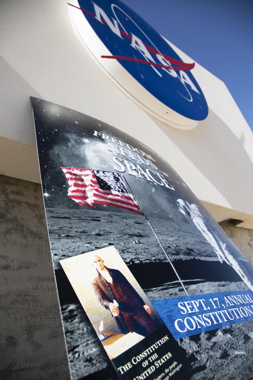
NASA's Kennedy Space Center in Florida observes U.S. Constitution Day, the official birthday of our U.S. government, with the theme "Freedom Needs Space." A remembrance poster made appearances in various locations around the multi-user spaceport, including at the new Headquarters Campus building. Constitution Day is an American federal observance. It recognizes the adoption of the U.S. Constitution and those who have become U.S. citizens. Constitution Day is observed on Sept. 17, the day in 1787 that delegates to the Constitutional Convention signed the document in Philadelphia.
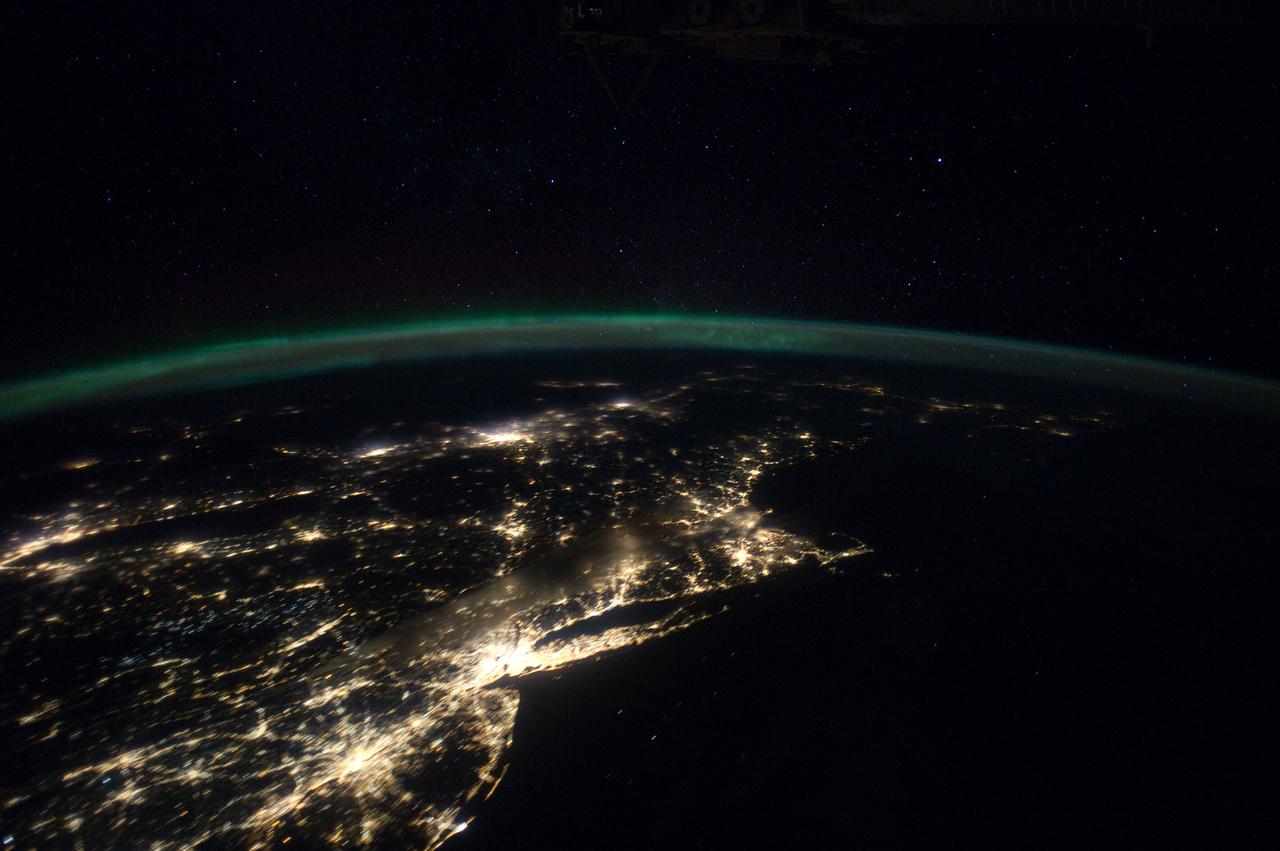
iss070e098484 (Feb., 23, 2024) --- This nightime view shows major northeastern U.S. urban centers including a cloudy New York City; Philadelphia, Pennsylvania; Providence, Rhode Island; Boston Massachussetts; and more. Expedition 70 Flight Engineer Loral O'Hara of NASA photographed the area as the International Space Station orbited 262 miles above the Gulf of Maine.

STS003-10-606 (30 March 1982) --- The entire state of New Jersey (39.5N, 74.5W) is seen in great detail in this photograph. Philadelphia, PA on the west bank of the Delaware River and Camden, NJ on the east bank of this natural boundary, are easily seen as well as the coastal resort of Atlantic City. Further north, New York City and most of Long Island can be seen in fair detail while further inland, the northern Appalachian Mountains can be seen going diagonal across the scene. Photo credit: NASA

NASA's Kennedy Space Center in Florida observes U.S. Constitution Day, the official birthday of our U.S. government, with the theme "Freedom Needs Space." A remembrance poster made appearances in various locations around the multi-user spaceport, including near the iconic Vehicle Assembly Building. Constitution Day is an American federal observance. It recognizes the adoption of the U.S. Constitution and those who have become U.S. citizens. Constitution Day is observed on Sept. 17, the day in 1787 that delegates to the Constitutional Convention signed the document in Philadelphia.

NASA's Kennedy Space Center in Florida observes U.S. Constitution Day, the official birthday of our U.S. government, with the theme "Freedom Needs Space." A remembrance poster made appearances in various locations around the multi-user spaceport, including on the crawlerway, as the mobile launcher, atop crawler-transporter 2, in the background, slowly moves off of Launch Pad 39B for its trip to the Vehicle Assembly Building. Constitution Day is an American federal observance. It recognizes the adoption of the U.S. Constitution and those who have become U.S. citizens. Constitution Day is observed on Sept. 17, the day in 1787 that delegates to the Constitutional Convention signed the document in Philadelphia.
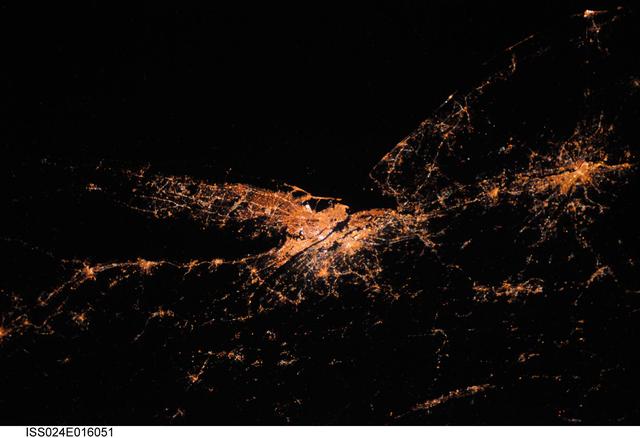
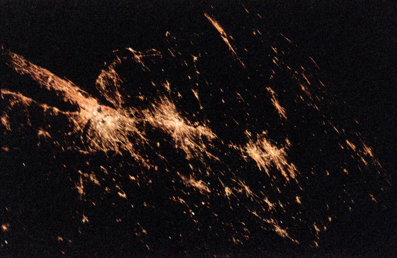
ISS024-E-016051 (27 Aug. 2010) --- This night time view captured by one of the Expedition 24 crew members aboard the International Space Station some 220 miles above Earth is looking down upon New York City. The actual nadir estimate is 39.1 degrees north latitude and 71.2 degrees west longitude or about 170 miles southeast of the city over the Atlantic. Philadelphia is also visible to the right. Long Island and the Connecticut coastal cities mark Long Island Sound. Atlantic City is that small bright spot in the upper right corner. The image was exposed in August and was physically brought back to Earth on a disk with the return of the Expedition 25 crew in November 2010.
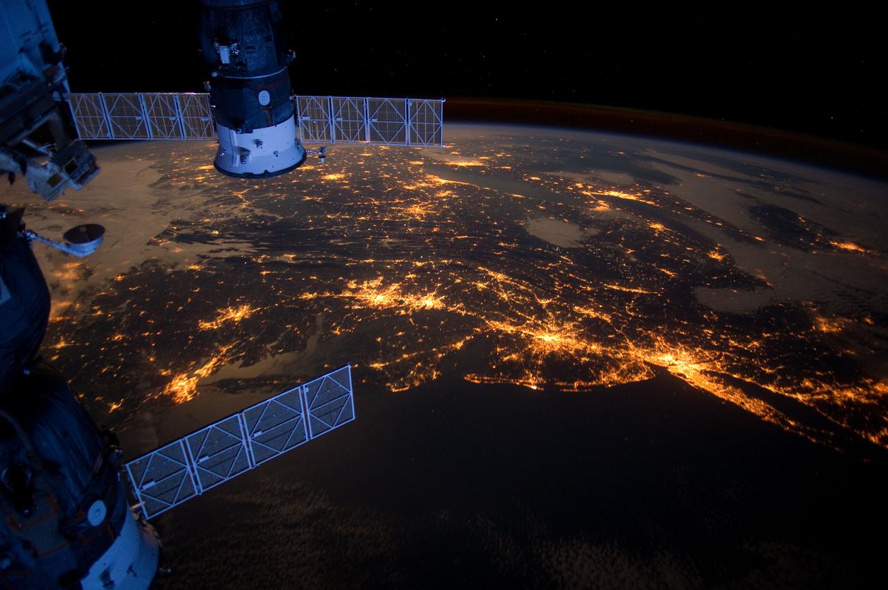
ISS030-E-078095 (6 Feb. 2012) --- One of the Expedition 30 crew members aboard the International Space Station took this nighttime photograph of much of the eastern (Atlantic) coast of the United States. Large metropolitan areas and other easily recognizable sites from the Virginia/Maryland/Washington, D.C. area spanning almost to Rhode Island are visible in the scene. Boston is just out of frame at right. Long Island and the Greater Metropolitan area of New York City are visible in the lower right quadrant. Large cities in Pennsylvania (Philadelphia and Pittsburgh) are near center. Parts of two Russian vehicles parked at the orbital outpost are seen in left foreground.
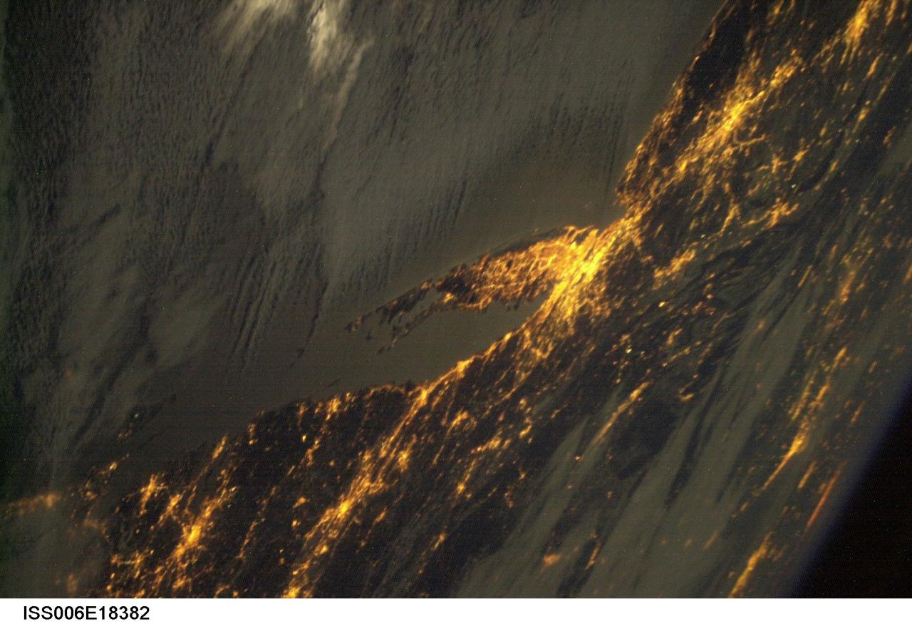
ISS006-E-18382 (January 2003) --- Bright city lights along the coastline and interior of the eastern coast of the United States were captured with a digital still camera by one of the Expedition Six crewmembers on board the International Space Station (ISS). This nighttime view shows New York City, the largest and brightest metropolitan area along the coast. The metropolitan area straddles the Hudson River and spreads eastward over western Long Island. The second largest city in this image is Philadelphia. The crew of the station took this image from a vantage point well to the northwest with the camera pointed back towards New York City and the coast. The result is that the perspective is highly distorted but still recognizable. Low clouds have formed over the waters of the Atlantic and have settled into some of the valleys of the Appalachian Mountains to the northwest.
STS098-382-0014 (7-20 February 2001) City Lights of the Northeastern Seaboard of the U.S. were captured with a 35mm camera by one of the STS-98 astronauts aboard the Space Shuttle Atlantis. The nighttime scene shows the bright lights of several major cities that span a distance from Connecticut (left middle) to states south of Virginia (right middle). Lights from both very large urban areas as well as smaller towns and cities are visible. The largest cluster of brightness emanates from the greater New York metropolitan area (left center) and then a series of bright spots progress southwesterly to include Philadelphia (PA), Baltimore (MD), Washington (D.C.), Richmond (VA), and finally ending with the Newport News/ Norfolk (VA) lights (top center). Many of the major ground transportation arteries can be seen as radial, linear features that radiate outward from the central business districts of the cities. Even the lights of smaller cities such as Allentown, Reading, Lancaster, York, and Harrisburg (PA) are visible (bottom center).
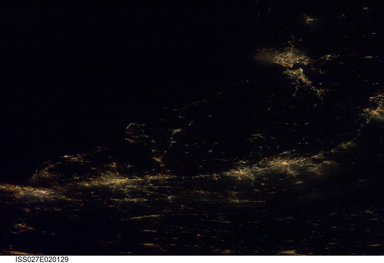
ISS027-E-020129 (6 April 2011) --- A night time view of the Atlantic Seaboard Conurbation, United States of America, is featured in this image photographed by an Expedition 27 crew member on the International Space Station. As regional metropolitan areas expand in both physical area and population, they typically aggregate to form economically, politically, and to some extent socially linked entities known as conurbations – the term “megalopolis” has also been used. One of the largest conurbations in the world is located along the eastern coastline of the United States, and has been termed the Atlantic Seaboard Conurbation (ASC). The ASC extends over 1,000 kilometers and includes the major economic, governmental, and cultural centers of Boston, Mass.; New York, N.Y.; Philadelphia, Pa.; Baltimore, Md.; and Washington, D.C. This photograph includes every metropolitan area in the ASC except for Boston, Mass. (located off the image to the northeast of New York, N.Y.). The image was taken during “local night”, which highlights the position and extent of each metropolitan area along the eastern seaboard by their urban lighting patterns. The establishment and growth of the conurbation was facilitated by transportation networks (railroads, highways, and air travel routes) for transfer of goods, materials, and population between the metropolitan areas. Two other large metropolitan areas are visible in the image – Norfolk, Va. and Richmond, Va. at upper right – but these are not considered to be part of the ASC. In contrast to the city lights that mark metropolitan areas and smaller communities along the sea coast and interior, the Atlantic Ocean appears as a featureless dark region occupying the upper left quarter of the image.
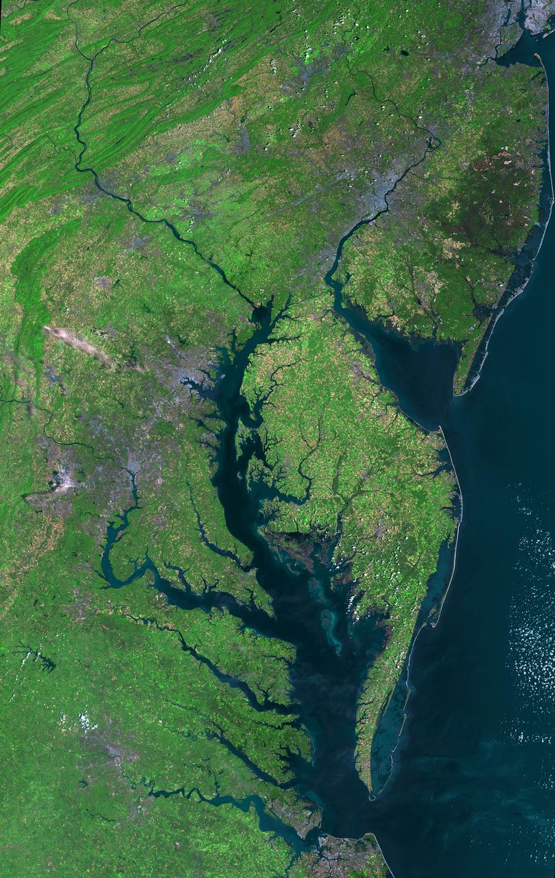
Aug 30, 2011 USGS has released a new mosaic of the Chesapeake Bay. Using six Landsat 5 images collected in July 2009 and 2011 a beautiful, seamless mosaic of the Chesapeake Bay region was created by the USGS Landsat team. The Washington D.C.-Baltimore-Philadelphia-New York City corridor can be clearly seen (look for silvery purple) as can the Chesapeake and Delaware Bays and the coastal Atlantic barrier islands from Fishermans Island, Virginia to Sandy Hook, New Jersey. To download the full high res go to: <a href="http://landsat.gsfc.nasa.gov/news/news-archive/news_0387.html" rel="nofollow">landsat.gsfc.nasa.gov/news/news-archive/news_0387.html</a> Credit: NASA/USGS/Landsat 5 <b><a href="http://www.nasa.gov/centers/goddard/home/index.html" rel="nofollow">NASA Goddard Space Flight Center</a></b> enables NASA’s mission through four scientific endeavors: Earth Science, Heliophysics, Solar System Exploration, and Astrophysics. Goddard plays a leading role in NASA’s accomplishments by contributing compelling scientific knowledge to advance the Agency’s mission. <b>Follow us on <a href="http://twitter.com/NASA_GoddardPix" rel="nofollow">Twitter</a></b> <b>Like us on <a href="http://www.facebook.com/pages/Greenbelt-MD/NASA-Goddard/395013845897?ref=tsd" rel="nofollow">Facebook</a></b> <b>Find us on <a href="http://instagrid.me/nasagoddard/?vm=grid" rel="nofollow">Instagram</a></b>