
From left, Project Scientist Natasha Haveman and NASA astronauts Jessica Watkins, Stan Love, and Luke Delaney, along with CSA (Canadian Space Agency) astronaut Joshua Kutryk, view crops grown in the Plant Processing Area inside the Space Systems Processing Facility at NASA’s Kennedy Space Center in Florida during a tour on Tuesday, May 12, 2026. Watkins, Delaney, and Kutryk, along with Roscosmos cosmonaut Sergey Teteryatnikov (not pictured), are part of NASA's SpaceX Crew-13 mission to the International Space Station and will explore the possibility of growing crops outside of the station’s Veggie chamber – one of two enclosed areas currently used to grow crops on the orbiting laboratory.

Project Scientist Natasha Haveman (right) shows NASA astronauts Jessica Watkins and Stan Love microgreens grown in the Plant Processing Area inside the Space Systems Processing Facility at NASA’s Kennedy Space Center in Florida during a tour on Tuesday, May 12, 2026. Watkins and NASA astronaut Luke Delaney, along with CSA (Canadian Space Agency) astronaut Joshua Kutryk, and Roscosmos cosmonaut Sergey Teteryatnikov (not pictured), are part of NASA's SpaceX Crew-13 mission to the International Space Station and will explore the possibility of growing crops outside of the station’s Veggie chamber – one of two enclosed areas currently used to grow crops on the orbiting laboratory.

From left, Trent Smith, a senior leader of the NASA Kennedy Space Crop Production team, welcomes NASA astronaut Jessica Watkins, CSA (Canadian Space Agency) astronaut Joshua Kutryk, and NASA astronaut Luke Delaney to the Plant Processing Area inside the Space Systems Processing Facility at NASA’s Kennedy Space Center in Florida for a tour of the facility on Tuesday, May 12, 2026. Watkins, Delaney, and Kutryk, along with Roscosmos cosmonaut Sergey Teteryatnikov (not pictured), are part of NASA's SpaceX Crew-13 mission to the International Space Station and will explore the possibility of growing crops outside of the station’s Veggie chamber – one of two enclosed areas currently used to grow crops on the orbiting laboratory.

From left, CSA (Canadian Space Agency) astronaut Joshua Kutryk and NASA astronaut Jessica Watkins taste microgreens at the Plant Processing Area inside the Space Systems Processing Facility at NASA’s Kennedy Space Center in Florida on Tuesday, May 12, 2026. Watkins and Kutryk, along with NASA astronaut Luke Delaney and Roscosmos cosmonaut Sergey Teteryatnikov (not pictured), are part of NASA's SpaceX Crew-13 mission to the International Space Station and will explore the possibility of growing crops outside of the station’s Veggie chamber – one of two enclosed areas currently used to grow crops on the orbiting laboratory.

From left, Project Scientist Natasha Haveman and NASA astronauts Luke Delaney and Stan Love view microgreens during a tour of the Plant Processing Area inside the Space Systems Processing Facility at NASA’s Kennedy Space Center in Florida on Tuesday, May 12, 2026. Delaney, NASA astronaut Jessica Watkins, and CSA (Canadian Space Agency) astronaut Joshua Kutryk, along with Roscosmos cosmonaut Sergey Teteryatnikov (not pictured), are part of NASA's SpaceX Crew-13 mission to the International Space Station and will explore the possibility of growing crops outside of the station’s Veggie chamber – one of two enclosed areas currently used to grow crops on the orbiting laboratory.

This photograph shows microgreens grown at the Plant Processing Area inside the Space Systems Processing Facility at NASA’s Kennedy Space Center in Florida on Tuesday, May 12, 2026. NASA Kennedy is home to the agency’s space crop production research efforts, including a team focused on growing crops to feed astronauts at the International Space Station and on other long duration missions to the Moon and Mars.

NASA astronaut Luke Delaney (front), along with CSA (Canadian Space Agency) astronaut Joshua Kutryk, NASA astronauts Jessica Watkins and Stan Love, Project Scientist Natasha Haveman, and Trent Smith, a senior leader of the NASA Kennedy Space Crop Production team, view microgreens at the Plant Processing Area inside the Space Systems Processing Facility at NASA’s Kennedy Space Center in Florida on Tuesday, May 12, 2026. Watkins, Delaney, Kutryk, and Roscosmos cosmonaut Sergey Teteryatnikov (not pictured) are part of NASA's SpaceX Crew-13 mission to the International Space Station and will explore the possibility of growing crops outside of the station’s Veggie chamber – one of two enclosed areas currently used to grow crops on the orbiting laboratory.

From left, Natasha Haveman, project scientist, NASA astronaut Jessica Watkins, Trent Smith, a senior leader of the NASA Kennedy Space Crop Production team, NASA astronauts Stan Love and Luke Delaney, and CSA (Canadian Space Agency) astronaut Joshua Kutryk view crops grown in the Plant Processing Area inside the Space Systems Processing Facility at NASA’s Kennedy Space Center in Florida during a tour on Tuesday, May 12, 2026. Watkins, Delaney, and Kutryk, along with Roscosmos cosmonaut Sergey Teteryatnikov (not pictured), are part of NASA's SpaceX Crew-13 mission to the International Space Station and will explore the possibility of growing crops outside of the station’s Veggie chamber – one of two enclosed areas currently used to grow crops on the orbiting laboratory.

Horticulture scientist Blake Costine adjusts moisture sensors for the Advanced Plant Imaging project at NASA’s Kennedy Space Center on April 17, 2023. In this project, hyperspectral cameras are used to assess plant health. The activity is taking place inside the Plant Production Area at the Florida spaceport’s Space Station Processing Facility.

Shown here are moisture sensors for the Advanced Plant Imaging project at NASA’s Kennedy Space Center on April 17, 2023. In this project, hyperspectral cameras are used to assess plant health. The activity is taking place inside the Plant Production Area at the Florida spaceport’s Space Station Processing Facility.

Horticulture scientist Blake Costine adjusts moisture sensors for the Advanced Plant Imaging project at NASA’s Kennedy Space Center on April 17, 2023. In this project, hyperspectral cameras are used to assess plant health. The activity is taking place inside the Plant Production Area at the Florida spaceport’s Space Station Processing Facility.

Horticulturalists study the use of 3D printed materials as media to grow plants at NASA’s Kennedy Space Center on April 17, 2023. The activity is taking place inside the Plant Production Area at the Florida spaceport’s Space Station Processing Facility.

Lead horticulturist LaShelle Spencer studies the use of 3D printed materials as media to grow plants at NASA’s Kennedy Space Center on April 17, 2023. The activity is taking place inside the Plant Production Area at the Florida spaceport’s Space Station Processing Facility.

Cucumbers are grown in a controlled environment chamber at NASA’s Kennedy Space Center on April 17, 2023. The activity is taking place inside the Plant Production Area at the Florida spaceport’s Space Station Processing Facility.

Melons are grown in a controlled environment chamber at NASA’s Kennedy Space Center on April 17, 2023. The activity is taking place inside the Plant Production Area at the Florida spaceport’s Space Station Processing Facility.

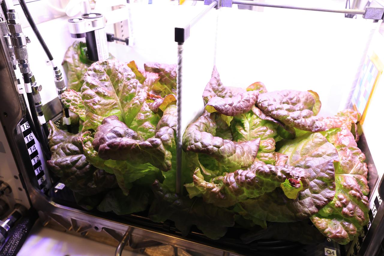
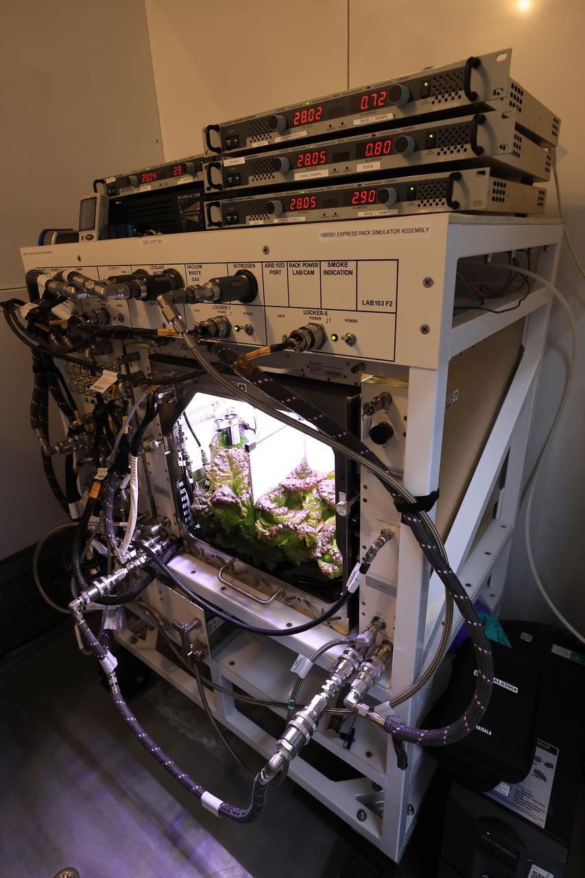
Shown here are microgreens – a quick-growing, highly nutritious crop – inside the Plant Production Area at NASA’s Kennedy Space Center’s Space Station Processing Facility in Florida on April 17, 2023. The microgreens will be used to make mixes to create complex flavors to help with menu fatigue in space.
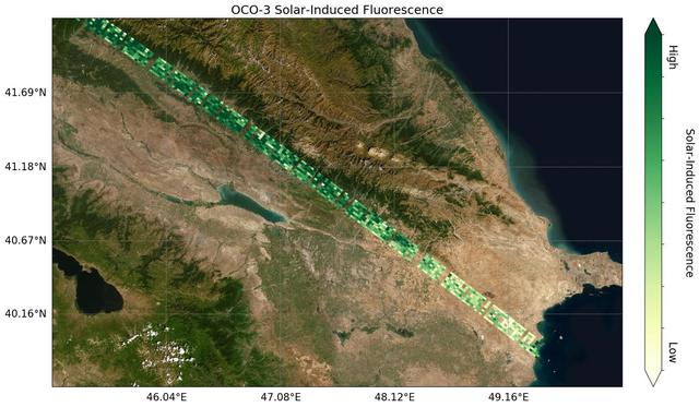
Image shows OCO-3's first preliminary solar-induced fluorescence (SIF) measurements over western Asia. Solar-induced fluorescence is the glow plants emit from photosynthesis — the process of plant growth that includes the capture of carbon from the atmosphere. Areas with lower photosynthesis activity are in shown in light green; areas with higher photosynthesis activity are shown in dark green. As expected, there is significant contrast in plant activity from areas of low vegetation near the Caspian Sea to areas of more dense vegetation like the forests and farms north and east of the Mingachevir Reservoir (near the center of the image). The mission team expects to complete OCO-3's In-orbit checkout phase — the period where they ensure all instruments and components are working and calibrated correctly — in August 2019. They are scheduled to release official CO2 and solar-induced fluorescence data to the science community a year later; however, the data will likely be available sooner given the quality of the measurements that OCO-3 is already making. https://photojournal.jpl.nasa.gov/catalog/PIA23353
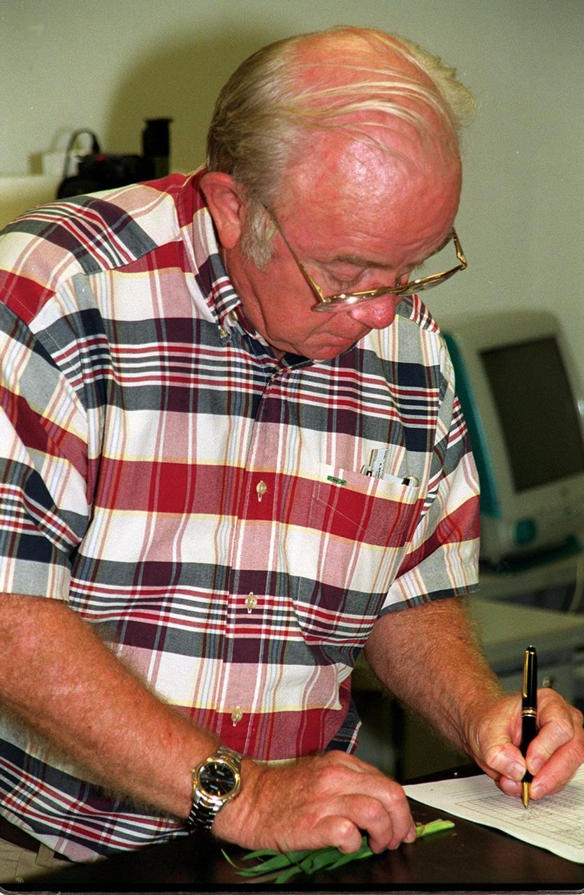
Research scientist Oscar Monje records data associated with ground testing for the first International Space Station plant experiment, scheduled to fly in October 2001. The payload process testing is one of many studies being performed at the Biological Sciences Branch in the Spaceport Engineering and Technology Directorate at Kennedy Space Center. The branch's operations and research areas include life sciences Space Shuttle payloads, bioregenerative life-support for long-duration spaceflight and environmental/ecological stewardship
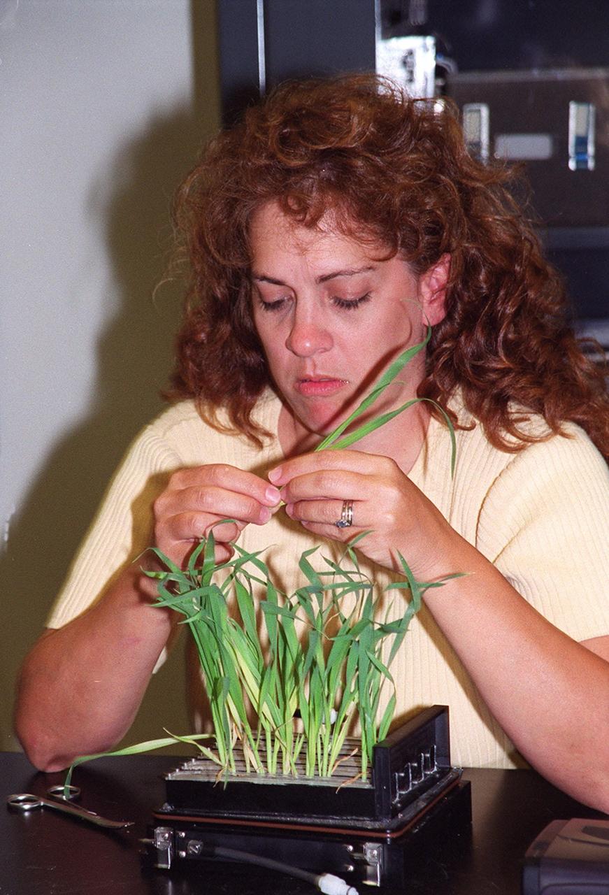
Research technician Lisa Ruffa works with a wheat sample that is part of ground testing for the first International Space Station plant experiment, scheduled to fly in October 2001. The payload process testing is one of many studies being performed at the Biological Sciences Branch in the Spaceport Engineering and Technology Directorate at Kennedy Space Center. The branch's operations and research areas include life sciences Space Shuttle payloads, bioregenerative life-support for long-duration spaceflight and environmental/ecological stewardship
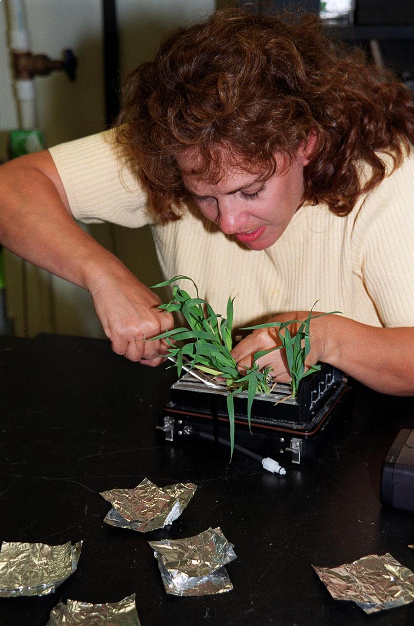
Research technician Lisa Ruffa works with a wheat sample that is part of ground testing for the first International Space Station plant experiment, scheduled to fly in October 2001. The payload process testing is one of many studies being performed at the Biological Sciences Branch in the Spaceport Engineering and Technology Directorate at Kennedy Space Center. The branch's operations and research areas include life sciences Space Shuttle payloads, bioregenerative life-support for long-duration spaceflight and environmental/ecological stewardship

Research technician Lisa Ruffa works with a wheat sample that is part of ground testing for the first International Space Station plant experiment, scheduled to fly in October 2001. The payload process testing is one of many studies being performed at the Biological Sciences Branch in the Spaceport Engineering and Technology Directorate at Kennedy Space Center. The branch's operations and research areas include life sciences Space Shuttle payloads, bioregenerative life-support for long-duration spaceflight and environmental/ecological stewardship
This photograph was taken during installation of floor grids on the upper and lower floors inside the Skylab Orbital Workshop at the McDornell Douglas plant at Huntington Beach, California. The OWS was divided into two major compartments. The lower level provided crew accommodations for sleeping, food preparation and consumption, hygiene, waste processing and disposal, and performance of certain experiments. The upper level consisted of a large work area and housed water storage tanks, a food freezer, storage vaults for film, scientific airlocks, mobility and stability experiment equipment, and other experimental equipment.
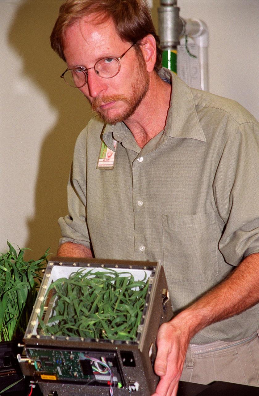
Research scientist Gary Stutte displays a wheat sample that is part of ground testing for the first International Space Station plant experiment, scheduled to fly in October 2001. The payload process testing is one of many studies being performed at the Biological Sciences Branch in the Spaceport Engineering and Technology Directorate at Kennedy Space Center. The branch's operations and research areas include life sciences Space Shuttle payloads, bioregenerative life-support for long-duration spaceflight and environmental/ecological stewardship

Research technician Lisa Ruffa works with a wheat sample that is part of ground testing for the first International Space Station plant experiment, scheduled to fly in October 2001. The payload process testing is one of many studies being performed at the Biological Sciences Branch in the Spaceport Engineering and Technology Directorate at Kennedy Space Center. The branch's operations and research areas include life sciences Space Shuttle payloads, bioregenerative life-support for long-duration spaceflight and environmental/ecological stewardship

Research scientist Gary Stutte displays a wheat sample that is part of ground testing for the first International Space Station plant experiment, scheduled to fly in October 2001. The payload process testing is one of many studies being performed at the Biological Sciences Branch in the Spaceport Engineering and Technology Directorate at Kennedy Space Center. The branch's operations and research areas include life sciences Space Shuttle payloads, bioregenerative life-support for long-duration spaceflight and environmental/ecological stewardship

Research scientist Oscar Monje records data associated with ground testing for the first International Space Station plant experiment, scheduled to fly in October 2001. The payload process testing is one of many studies being performed at the Biological Sciences Branch in the Spaceport Engineering and Technology Directorate at Kennedy Space Center. The branch's operations and research areas include life sciences Space Shuttle payloads, bioregenerative life-support for long-duration spaceflight and environmental/ecological stewardship
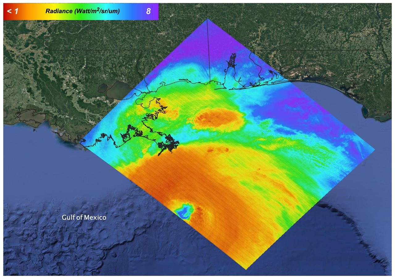
On August 27, 2021 Ida crossed over Cuba as a Category 1 Storm. 48 hours later the storm intensified to a Category 4 before making landfall on the coast of Louisiana. The storm was the second most destructive storm to ever make landfall on the Louisiana coast with sustained winds over 150 mph (240 km/h). The rapid intensification process that the storm system underwent is not well understood. Satellite images such as this are helpful as scientists attempt to understand new weather patterns that are emerging with Global Climate Change. Tasked with detecting plant water use and stress, ECOSTRESS's primary mission is to measure the temperature of plants heating up as they run out of water. But it can also measure and track heat-related phenomena like wildfires, heat waves, and volcanoes. ECOSTRESS observations have a spatial resolution of about 77 by 77 yards (70 by 70 meters), which enables researchers to study surface-temperature conditions down to the size of a football field. Due to the space station's unique orbit, the mission can acquire images of the same regions at different times of the day, as opposed to crossing over each area at the same time of day like satellites in other orbits do. This is advantageous when monitoring plant stress in the same area throughout the day, for example. https://photojournal.jpl.nasa.gov/catalog/PIA24210
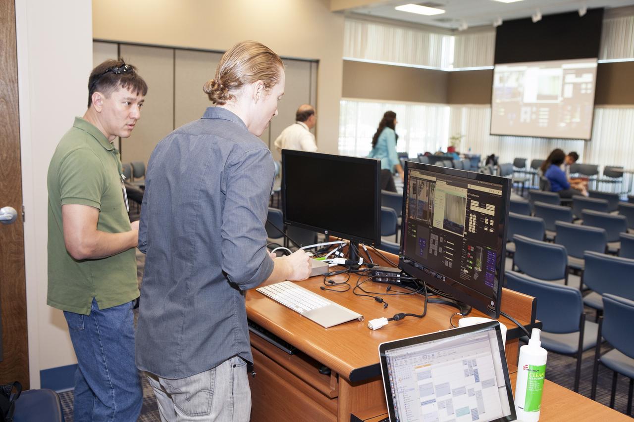
CAPE CANAVERAL, Fla. -- At the Kennedy Space Center in Florida, students from the University of Colorado Boulder demonstrated a robotic capability for growing a variety of plants in a deep-space habitat. Daniel Zukowski, a University of Colorado Boulder graduate student, right, and Morgan Simpson of the NASA Ground Processing Directorate, check computer displays during a presentation of the team's entry in the eXploration HABitat X-Hab Academic Innovation Challenge. In their concept called "Plants Anywhere: Plants Growing in Free Habitat Spaces," their approach calls for robotically tended plants to be scattered in any available space in a deep-space habitat instead of an area set aside just for vegetation. X-Hab Academic Innovation Challenge is a university-level activity designed to engage and retain students in science, technology, engineering and math, or STEM, disciplines. NASA will directly benefit from the effort by sponsoring the development of innovative habitat concepts from universities which may result in innovative ideas and solutions that could be applied to exploration habitats. For more: http://www.nasa.gov/exploration/technology/deep_space_habitat/xhab/ Photo credit: NASA/Daniel Casper
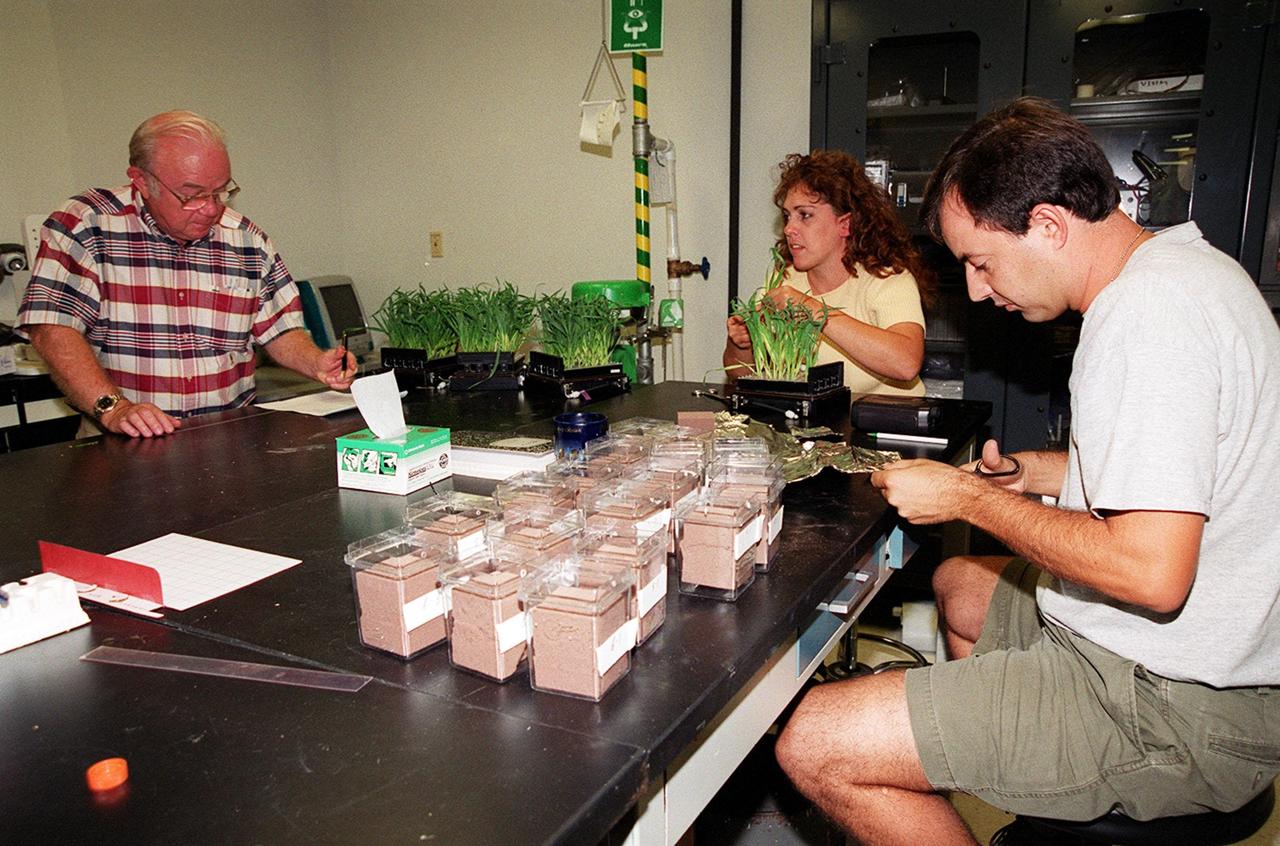
Researchers work with wheat samples that are part of ground testing for the first International Space Station plant experiment, scheduled to fly in October 2001. From left are research scientist Oscar Monje and research technicians Lisa Ruffa and Ignacio Eraso. The payload process testing they are performing is one of many studies at the Biological Sciences Branch in the Spaceport Engineering and Technology Directorate at Kennedy Space Center. The branch's operations and research areas include life sciences Space Shuttle payloads, bioregenerative life-support for long-duration spaceflight and environmental/ecological stewardship

Researchers work with wheat samples that are part of ground testing for the first International Space Station plant experiment, scheduled to fly in October 2001. From left are research scientist Oscar Monje and research technicians Lisa Ruffa and Ignacio Eraso. The payload process testing they are performing is one of many studies at the Biological Sciences Branch in the Spaceport Engineering and Technology Directorate at Kennedy Space Center. The branch's operations and research areas include life sciences Space Shuttle payloads, bioregenerative life-support for long-duration spaceflight and environmental/ecological stewardship
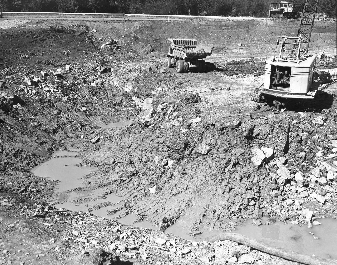
The Muruntau mine in Uzbekistan is the largest gold mine in the world in terms of production. In a single year, Muruntau produces over 2 million ounces of gold. Located in the Qizilqum Desert of Uzbekistan, it is the world's biggest open pit mine. The mine itself is roughly 3.3 km long, 3 km wide and 600 m deep, with its large heap-leach processing plant to the east. Within this huge mine, there is believed to be reserves of over 170 million ounces of gold. The image was acquired July 11, 2021, covers an area of 22.5 by 38.2 km, and is located at 41.5 degrees north, 64.6 degrees east. https://photojournal.jpl.nasa.gov/catalog/PIA25445
This is a photograph of the Spacelab module for the first United States Microgravity Laboratory (USML-1) mission, showing logos of the Spacelab mission on the left and the USML-1 mission on the right. The USML-1 was one part of a science and technology program that opened NASA's next great era of discovery and established the United States' leadership in space. From investigations designed to gather fundamental knowledge in a variety of areas to demonstrations of new equipment, USML-1 forged the way for future USML missions and helped prepare for advanced microgravity research and processing aboard the Space Station. Thirty-one investigations comprised the payload of the first USML-1 mission. The experiments aboard USML-1 covered five basic areas: fluid dynamics, the study of how liquids and gases respond to the application or absence of differing forces; crystal growth, the production of inorganic and organic crystals; combustion science, the study of the processes and phenomena of burning; biological science, the study of plant and animal life; and technology demonstrations. The USML-1 was managed by the Marshall Space Flight Center and launched aboard the Space Shuttle Orbiter Columbia (STS-50) on June 25, 1992.
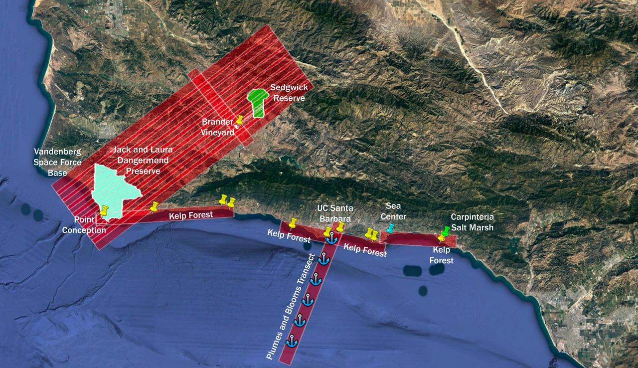
The Surface Biology and Geology High-Frequency Time Series (SHIFT) campaign employs a research plane carrying the AVIRIS-NG (Airborne Visible/Infrared Imaging Spectrometer-Next Generation) instrument. From late February to late May 2022, the plane is collecting spectral data of land and aquatic plant communities over a 640-square-mile (1,656-square-kilometer) study area in Santa Barbara County and the nearby ocean. SHIFT is jointly led by NASA's Jet Propulsion Laboratory, the University of California, Santa Barbara (UCSB), and The Nature Conservancy. The aerial portion of SHIFT flies on an approximately weekly basis over the study area, which includes the Jack and Laura Dangermond Preserve, owned by The Nature Conservancy, and the Sedgwick Reserve, operated by UCSB. SHIFT combines the ability of airborne science instruments to gather data over widespread areas with the more concentrated observations scientists conduct in the field to study the functional characteristics, health, and resilience of plant communities. The sampling and analysis done by researchers on the ground and in the ocean is intended to validate data taken by AVIRIS-NG and help scientists design data collection and processing algorithms for NASA's proposed Surface Biology and Geology (SBG) mission, which would launch no earlier than 2028. The data is also intended to support the research and conservation objectives of The Nature Conservancy, which owns the Dangermond Preserve, and UCSB, which operates the Sedgwick Reserve, another nature preserve within the study area. More than 60 scientists from institutions around the U.S. have indicated they intend to use the SHIFT data in their research. https://photojournal.jpl.nasa.gov/catalog/PIA25144
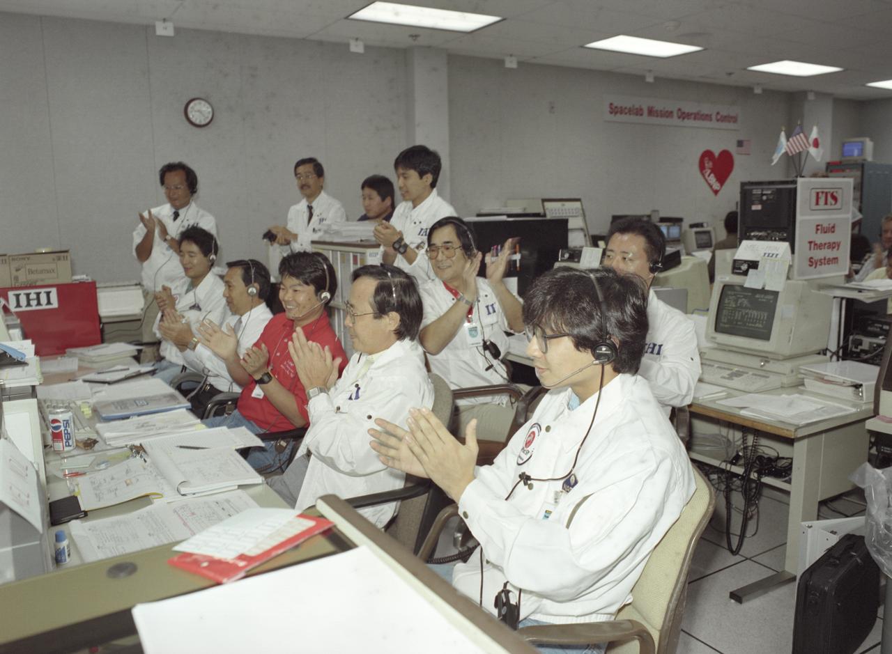
The science laboratory, Spacelab-J (SL-J), flown aboard the STS-47 flight was a joint venture between NASA and the National Space Development Agency of Japan (NASDA) utilizing a manned Spacelab module. The mission conducted 24 materials science and 20 life science experiments, of which 35 were sponsored by NASDA, 7 by NASA, and two collaborative efforts. Materials science investigations covered such fields as biotechnology, electronic materials, fluid dynamics and transport phenomena, glasses and ceramics, metals and alloys, and acceleration measurements. Life sciences included experiments on human health, cell separation and biology, developmental biology, animal and human physiology and behavior, space radiation, and biological rhythms. Test subjects included the crew, Japanese koi fish (carp), cultured animal and plant cells, chicken embryos, fruit flies, fungi and plant seeds, and frogs and frog eggs. Featured together in the Science Operation Area (SOA) are payload specialists’ first Materials Processing Test during NASA/NASDA joint ground activities at the Huntsville Operations Support Center (HOSC) Spacelab Payload Operations Control Center (SL POCC) at Marshall Space Flight Center (MSFC).
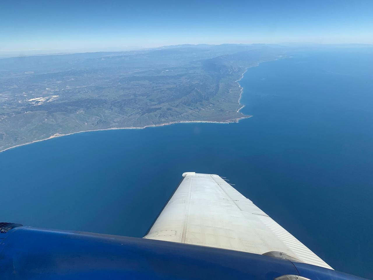
A research plane carrying the AVIRIS-NG (Airborne Visible/Infrared Imaging Spectrometer-Next Generation) instrument flies off the Central Coast of California near Point Conception and the Jack and Laura Dangermond Preserve on Feb. 24, 2022. The flight is part of the Surface Biology and Geology High-Frequency Time Series (SHIFT) campaign, which is jointly led by NASA's Jet Propulsion Laboratory, the University of California, Santa Barbara (UCSB), and The Nature Conservancy. Operating between late February and late May 2022, the aerial portion of SHIFT flies on an approximately weekly basis over a 640-square-mile (1,656-square-kilometer) study area in Santa Barbara County and the nearby ocean, collecting spectral data of plant communities it observes below. SHIFT combines the ability of airborne science instruments to gather data over widespread areas with the more concentrated observations scientists conduct in the field to study the functional characteristics, health, and resilience of plant communities. The sampling and analysis done by researchers on the ground and in the ocean is intended to validate data taken by AVIRIS-NG and help scientists design data collection and processing algorithms for NASA's proposed Surface Biology and Geology (SBG) mission, which would launch no earlier than 2028. The data is also intended to support the research and conservation objectives of The Nature Conservancy, which owns the Dangermond Preserve, and UCSB, which operates the Sedgwick Reserve, another nature preserve within the study area. More than 60 scientists from institutions around the U.S. have indicated they intend to use the SHIFT data in their research. AVIRIS-NG, which was designed at JPL, flies aboard Dynamic Aviation's King Air B-200. https://photojournal.jpl.nasa.gov/catalog/PIA25143
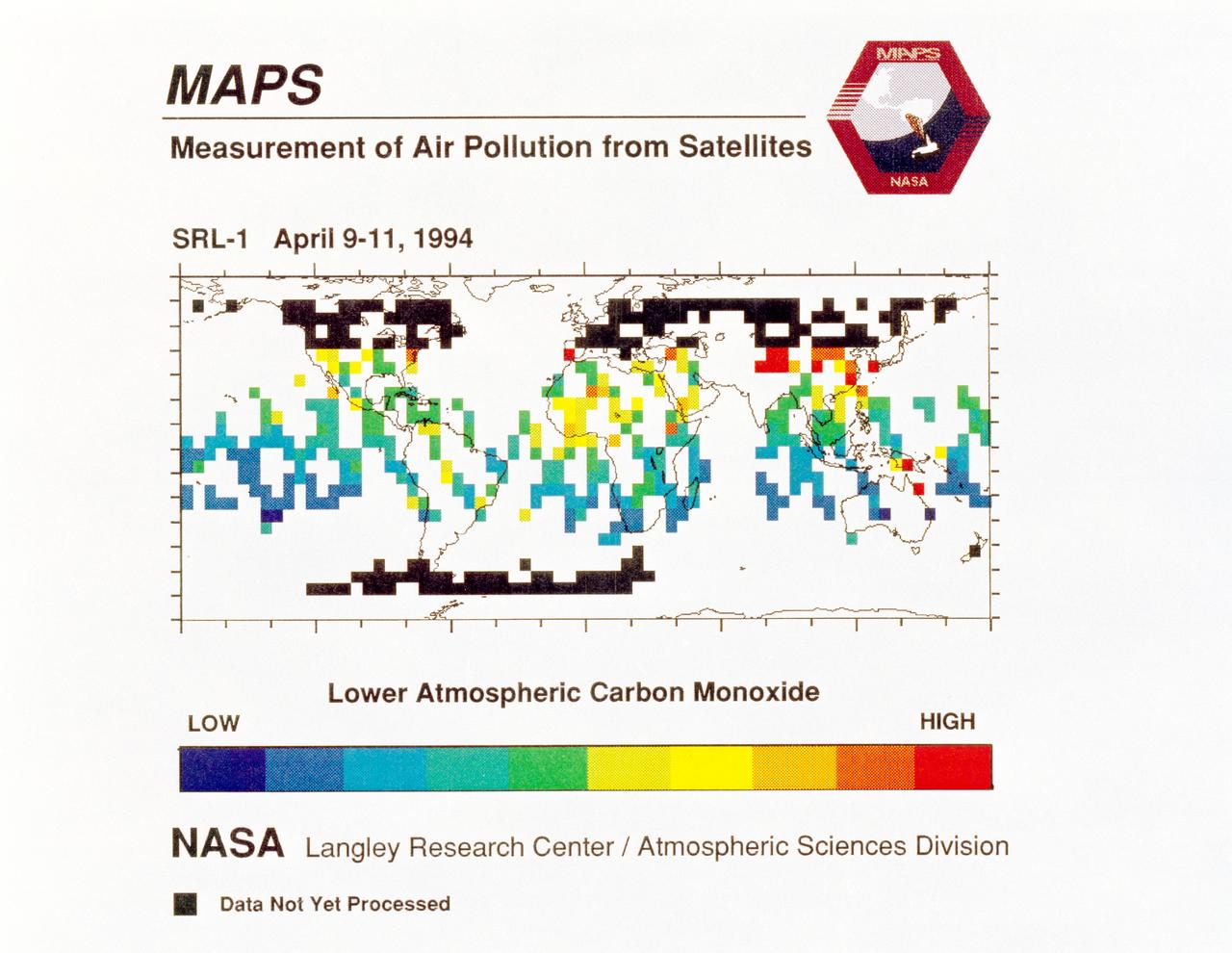
STS059-S-040 (12 April 1994) --- STS-59's MAPS (Measurement of Air Pollution from Satellites) experiment is sending real-time data that provides the most comprehensive view of carbon monoxide concentrations on Earth ever recorded. This computer image shows a summary of "quick look" data obtained by the MAPS instrument during its first days of operations as part of the Space Shuttle Endeavour's SRL-1 payload. This data will be processed using more sophisticated techniques following the flight. The color red indicates areas with the highest levels of carbon monoxide. These Northern Hemisphere springtime carbon monoxide values are generally significantly higher than the values found in the Southern Hemisphere. This is in direct contrast to the data obtained by the MAPS experiment during November 1981 and October 1984, i.e. during Northern Hemisphere fall. The astronauts aboard Endeavour have seen fires in most of the areas showing higher carbon monoxide values (China, Eastern Australia, and equatorial Africa). The relationship between the observed fires and the higher carbon monoxide values will be investigated following SRL-1 by combining the MAPS data with meteorological data, surface imagery, and Space Shuttle hand-held photographs. By the end of SRL-1, MAPS will have acquired data over most of the globe between 57 degrees north and 57 degrees south latitudes. The entire data set will be carefully analyzed using sophisticated post-flight data processing techniques. The data will then be applied in a variety of scientific studies concerning chemistry and transport processes in the atmosphere. The MAPS experiment measures the carbon monoxide in the lower atmosphere. This gas is produced both as a result of natural processes and as a result of human activities. The primary human resources of carbon monoxide are automobiles and industry and the burning of plant materials. The primary natural source is the interaction of sunlight with naturally occurring ozone and water vapor. The strength of all of these sources changes seasonally.
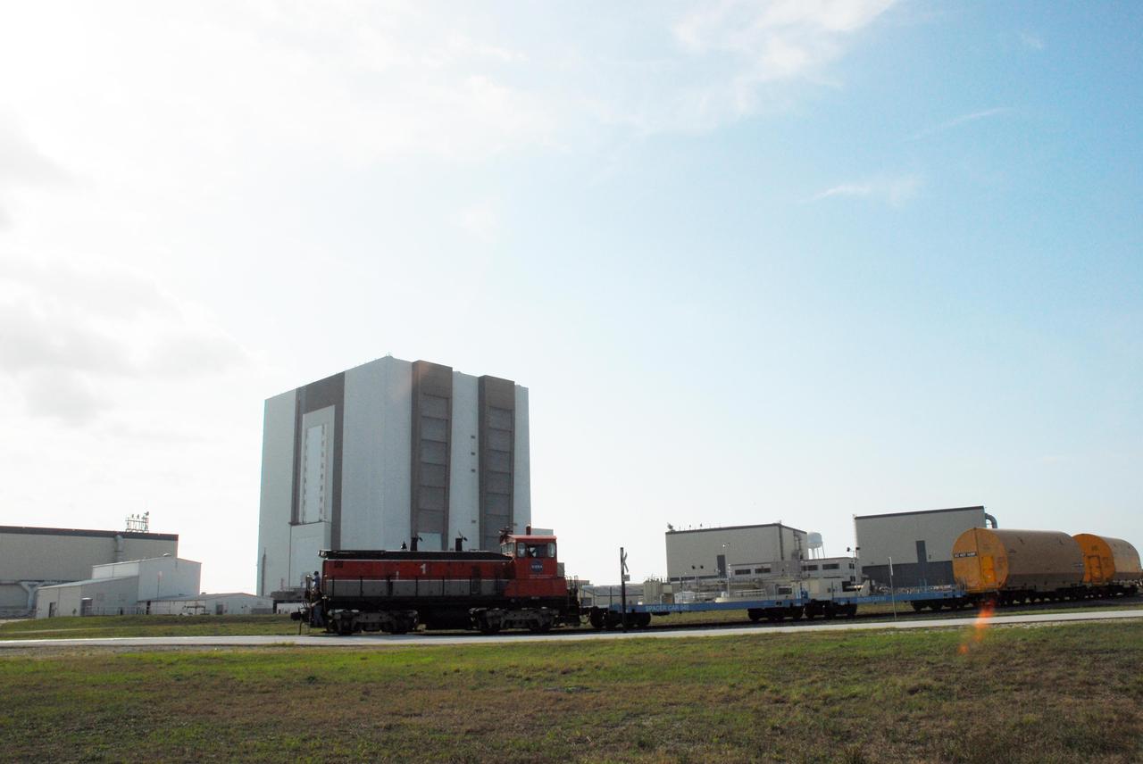
KENNEDY SPACE CENTER, FLA. -- The locomotive and rail cars carrying solid rocket booster motor segments and two aft exit cone segments roll past the Vehicle Assembly Building to the Rotation, Processing and Surge Facility (RPSF) in Kennedy Space Center's Launch Complex 39 Area. The RPSF is used for solid rocket motor receiving, rotation and inspection, and supports aft booster buildup. When live solid rocket motor segments arrive at the processing facility, they are positioned under one of the cranes. Handling slings are then attached to and remove the railcar cover. The segment is inspected while it remains horizontal. The two overhead cranes hoist the segment, rotate it to a vertical position and place it on a fixed stand. The aft handling ring is then removed. The segment is hoisted again and lowered onto a transportation and storage pallet, and the forward handling ring is removed to allow inspections. It is then transported to one of the surge buildings and temporarily stored until it is needed for booster stacking in the VAB. While enroute, solid rocket motor segments were involved in a derailment in Alabama. The rail cars carrying these segments remained upright and were undamaged. An inspection determined these segment cars could continue on to Florida. The segments themselves will undergo further evaluation at Kennedy before they are cleared for flight. Other segments involved in the derailment will be returned to a plant in Utah for further evaluation. Photo credit: NASA/George Shelton
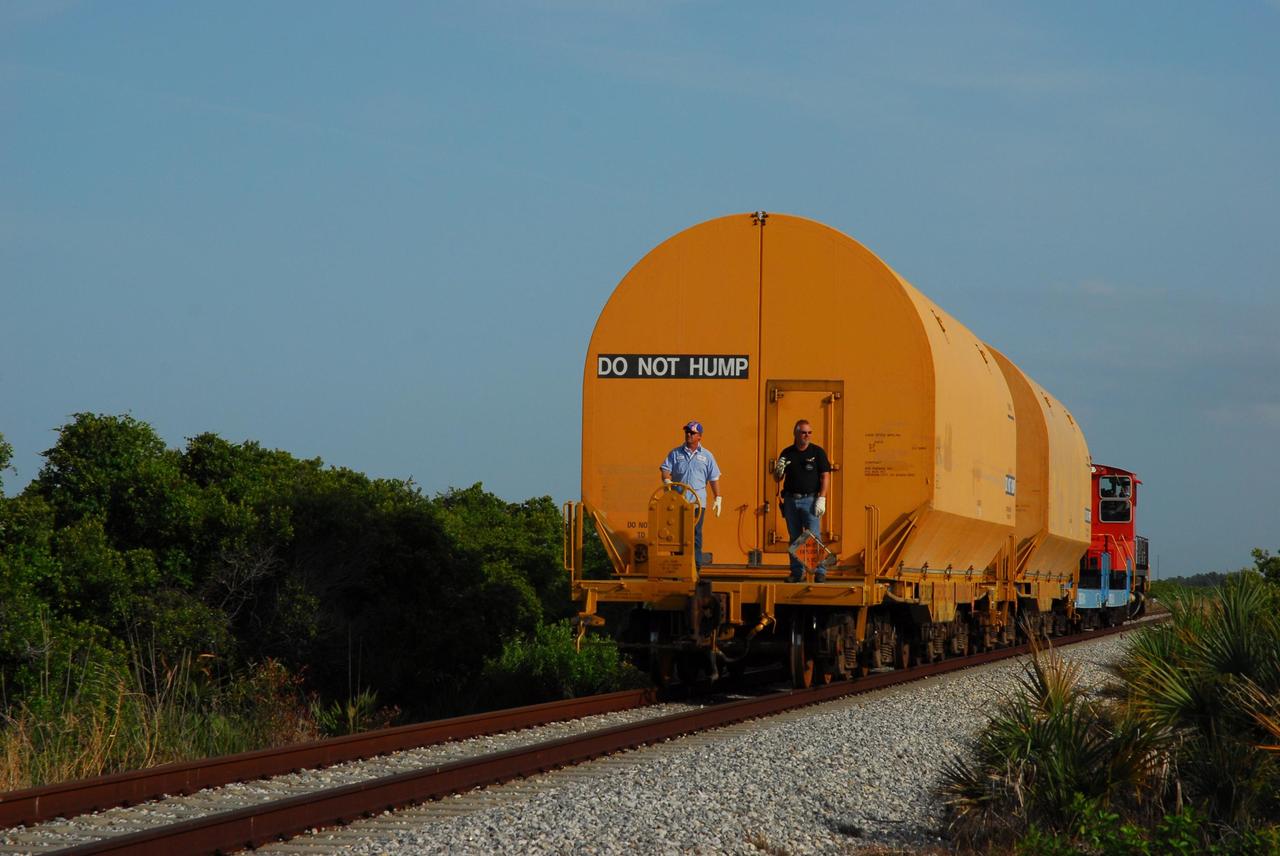
KENNEDY SPACE CENTER, FLA. -- The locomotive and rail cars carrying solid rocket booster motor segments and two aft exit cone segments roll to the Rotation, Processing and Surge Facility in Kennedy Space Center's Launch Complex 39 Area. The main facility is used for solid rocket motor receiving, rotation and inspection, and supports aft booster buildup. When live solid rocket motor segments arrive at the processing facility, they are positioned under one of the cranes. Handling slings are then attached to and remove the railcar cover. The segment is inspected while it remains horizontal. The two overhead cranes hoist the segment, rotate it to a vertical position and place it on a fixed stand. The aft handling ring is then removed. The segment is hoisted again and lowered onto a transportation and storage pallet, and the forward handling ring is removed to allow inspections. It is then transported to one of the surge buildings and temporarily stored until it is needed for booster stacking in the VAB. While enroute, solid rocket motor segments were involved in a derailment in Alabama. The rail cars carrying these segments remained upright and were undamaged. An inspection determined these segment cars could continue on to Florida. The segments themselves will undergo further evaluation at Kennedy before they are cleared for flight. Other segments involved in the derailment will be returned to a plant in Utah for further evaluation. Photo credit: NASA/George Shelton
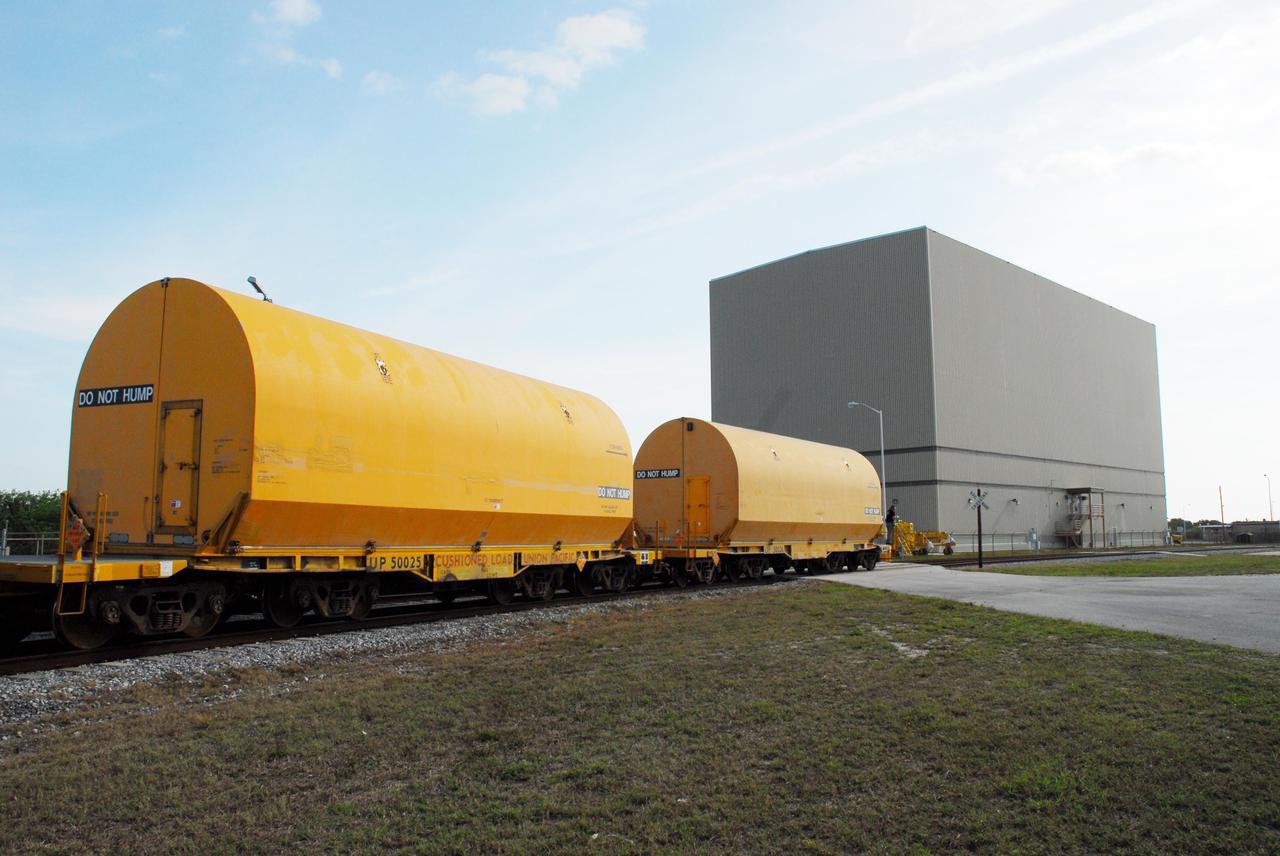
KENNEDY SPACE CENTER, FLA. -- The locomotive and rail cars carrying solid rocket booster motor segments and two aft exit cone segments roll toward the Rotation, Processing and Surge Facility (RPSF) in Kennedy Space Center's Launch Complex 39 Area. The RPSF is used for solid rocket motor receiving, rotation and inspection, and supports aft booster buildup. When live solid rocket motor segments arrive at the processing facility, they are positioned under one of the cranes. Handling slings are then attached to and remove the railcar cover. The segment is inspected while it remains horizontal. The two overhead cranes hoist the segment, rotate it to a vertical position and place it on a fixed stand. The aft handling ring is then removed. The segment is hoisted again and lowered onto a transportation and storage pallet, and the forward handling ring is removed to allow inspections. It is then transported to one of the surge buildings and temporarily stored until it is needed for booster stacking in the VAB. While enroute, solid rocket motor segments were involved in a derailment in Alabama. The rail cars carrying these segments remained upright and were undamaged. An inspection determined these segment cars could continue on to Florida. The segments themselves will undergo further evaluation at Kennedy before they are cleared for flight. Other segments involved in the derailment will be returned to a plant in Utah for further evaluation. Photo credit: NASA_George Shelton
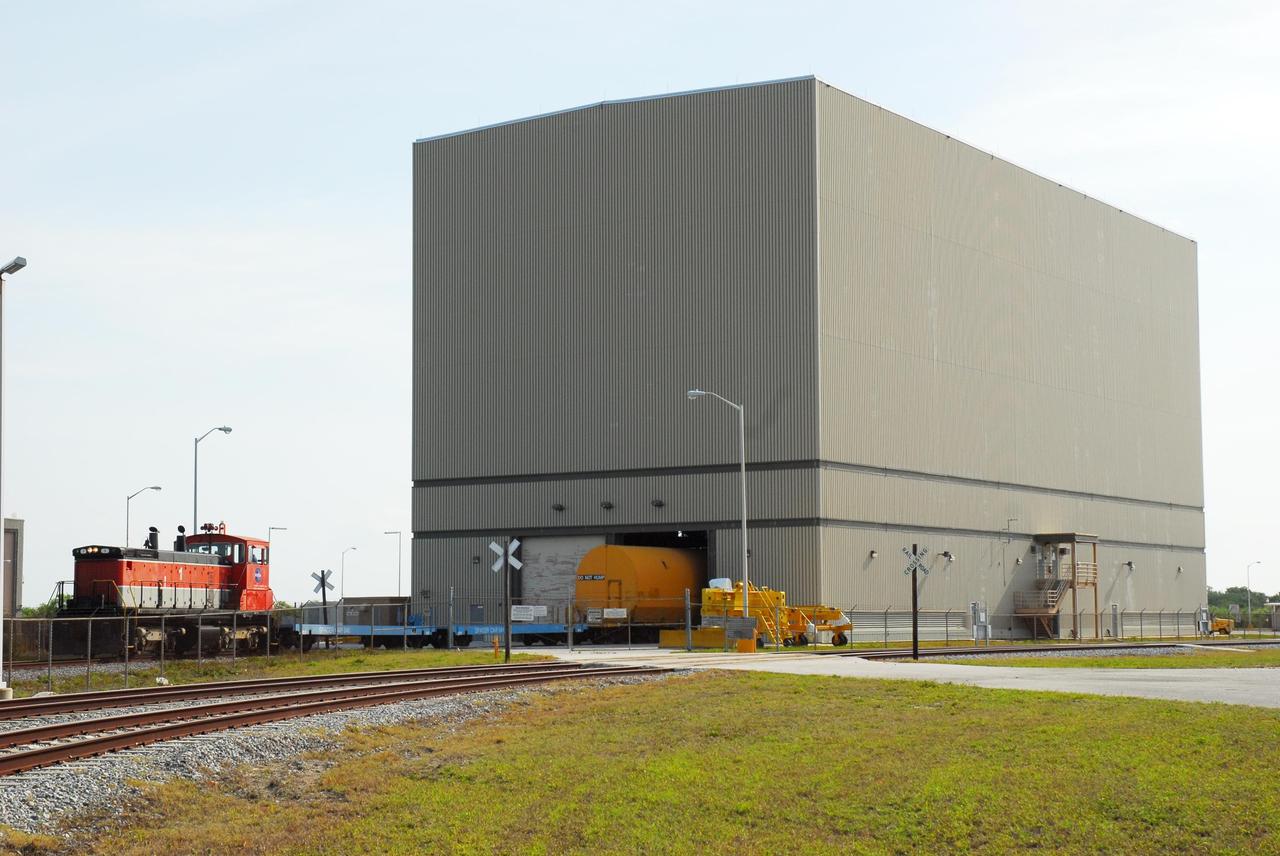
KENNEDY SPACE CENTER, FLA. -- The final rail car carrying solid rocket booster motor segments moves its cargo into the Rotation, Processing and Surge Facility (RPSF) in Kennedy Space Center's Launch Complex 39 Area. The RPSF is used for solid rocket motor receiving, rotation and inspection, and supports aft booster buildup. When live solid rocket motor segments arrive at the processing facility, they are positioned under one of the cranes. Handling slings are then attached to and remove the railcar cover. The segment is inspected while it remains horizontal. The two overhead cranes hoist the segment, rotate it to a vertical position and place it on a fixed stand. The aft handling ring is then removed. The segment is hoisted again and lowered onto a transportation and storage pallet, and the forward handling ring is removed to allow inspections. It is then transported to one of the surge buildings and temporarily stored until it is needed for booster stacking in the VAB. While enroute, solid rocket motor segments were involved in a derailment in Alabama. The rail cars carrying these segments remained upright and were undamaged. An inspection determined these segment cars could continue on to Florida. The segments themselves will undergo further evaluation at Kennedy before they are cleared for flight. Other segments involved in the derailment will be returned to a plant in Utah for further evaluation. Photo credit: NASA/George Shelton
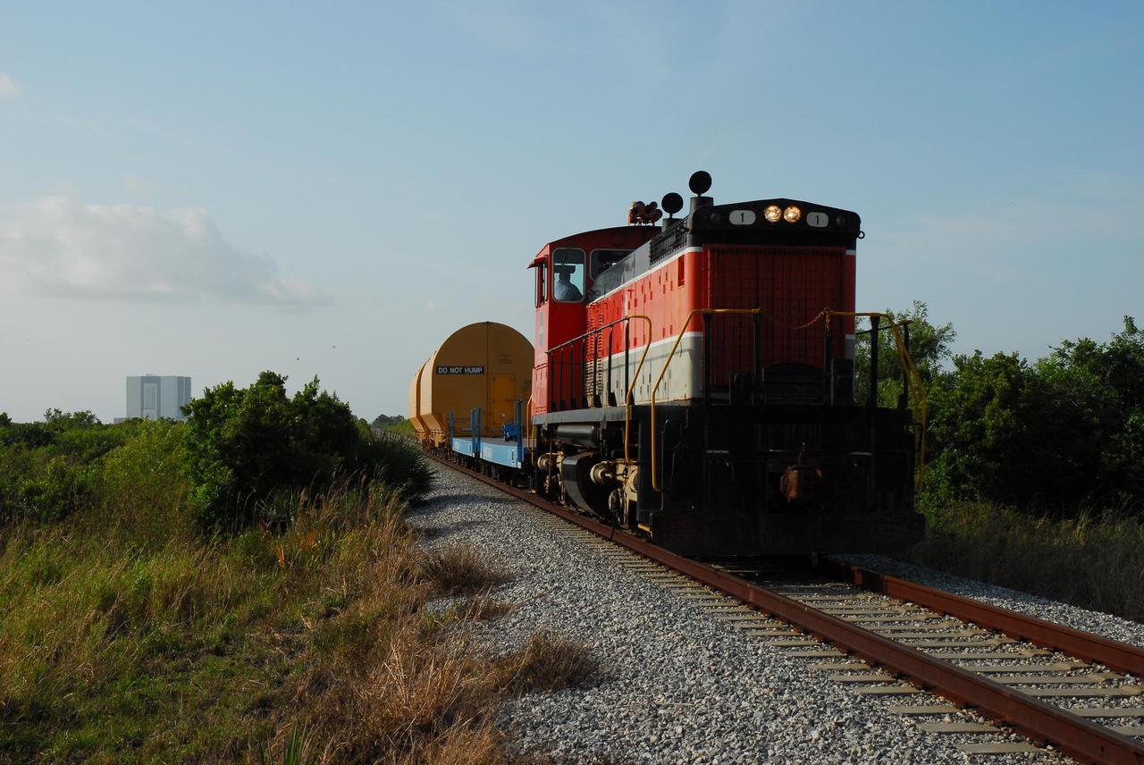
KENNEDY SPACE CENTER, FLA. -- The locomotive and rail cars carrying solid rocket booster motor segments and two aft exit cone segments roll to the Rotation, Processing and Surge Facility (RPSF) in Kennedy Space Center's Launch Complex 39 Area. In the background, at left, is the Vehicle Assembly Building. The RPSF is used for solid rocket motor receiving, rotation and inspection, and supports aft booster buildup. When live solid rocket motor segments arrive at the processing facility, they are positioned under one of the cranes. Handling slings are then attached to and remove the railcar cover. The segment is inspected while it remains horizontal. The two overhead cranes hoist the segment, rotate it to a vertical position and place it on a fixed stand. The aft handling ring is then removed. The segment is hoisted again and lowered onto a transportation and storage pallet, and the forward handling ring is removed to allow inspections. It is then transported to one of the surge buildings and temporarily stored until it is needed for booster stacking in the VAB. While enroute, solid rocket motor segments were involved in a derailment in Alabama. The rail cars carrying these segments remained upright and were undamaged. An inspection determined these segment cars could continue on to Florida. The segments themselves will undergo further evaluation at Kennedy before they are cleared for flight. Other segments involved in the derailment will be returned to a plant in Utah for further evaluation. Photo credit: NASA/George Shelton
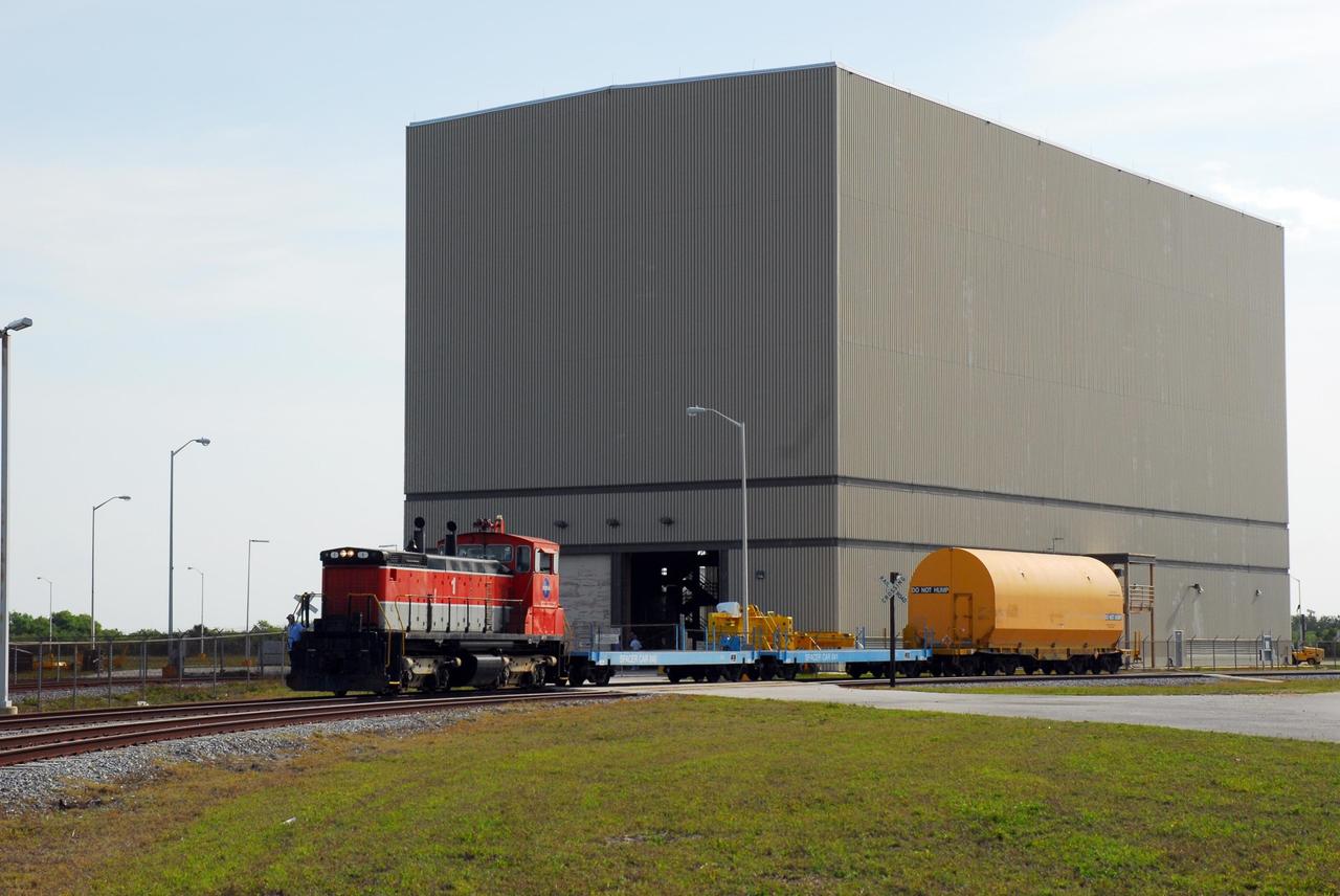
KENNEDY SPACE CENTER, FLA. -- The locomotive and rail cars carrying solid rocket booster motor segments and two aft exit cone segments deliver their cargo to the Rotation, Processing and Surge Facility (RPSF) in Kennedy Space Center's Launch Complex 39 Area. The RPSF is used for solid rocket motor receiving, rotation and inspection, and supports aft booster buildup. When live solid rocket motor segments arrive at the processing facility, they are positioned under one of the cranes. Handling slings are then attached to and remove the railcar cover. The segment is inspected while it remains horizontal. The two overhead cranes hoist the segment, rotate it to a vertical position and place it on a fixed stand. The aft handling ring is then removed. The segment is hoisted again and lowered onto a transportation and storage pallet, and the forward handling ring is removed to allow inspections. It is then transported to one of the surge buildings and temporarily stored until it is needed for booster stacking in the VAB. While enroute, solid rocket motor segments were involved in a derailment in Alabama. The rail cars carrying these segments remained upright and were undamaged. An inspection determined these segment cars could continue on to Florida. The segments themselves will undergo further evaluation at Kennedy before they are cleared for flight. Other segments involved in the derailment will be returned to a plant in Utah for further evaluation. Photo credit: NASA/George Shelton
Plant biologists inside a laboratory in the Space Systems Processing Facility at NASA’s Kennedy Space Center in Florida, prepare to harvest Outredgeous romaine lettuce growing in the Advanced Plant Habitat ground unit as the ground control portion of the Plant Habitat-07 (PH-07) experiment on Thursday, April 24, 2025. PH-07 was sent to the International Space Station on NASA’s SpaceX 31st commercial resupply services mission to study how optimal and suboptimal moisture conditions impact plant growth, nutrient content, and the plant microbiome.
Plant biologists inside a laboratory in the Space Systems Processing Facility at NASA’s Kennedy Space Center in Florida, prepare to harvest Outredgeous romaine lettuce growing in the Advanced Plant Habitat ground unit as the ground control portion of the Plant Habitat-07 (PH-07) experiment on Thursday, April 24, 2025. PH-07 was sent to the International Space Station on NASA’s SpaceX 31st commercial resupply services mission to study how optimal and suboptimal moisture conditions impact plant growth, nutrient content, and the plant microbiome.
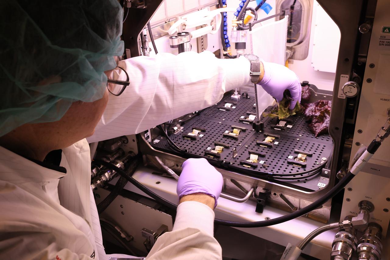
Inside a laboratory in the Space Systems Processing Facility at NASA’s Kennedy Space Center in Florida, a plant biologist harvests Outredgeous romaine lettuce growing in the Advanced Plant Habitat ground unit as the ground control portion of the Plant Habitat-07 (PH-07) experiment on Thursday, April 24, 2025. PH-07 was sent to the International Space Station on NASA’s SpaceX 31st commercial resupply services mission to study how optimal and suboptimal moisture conditions impact plant growth, nutrient content, and the plant microbiome.
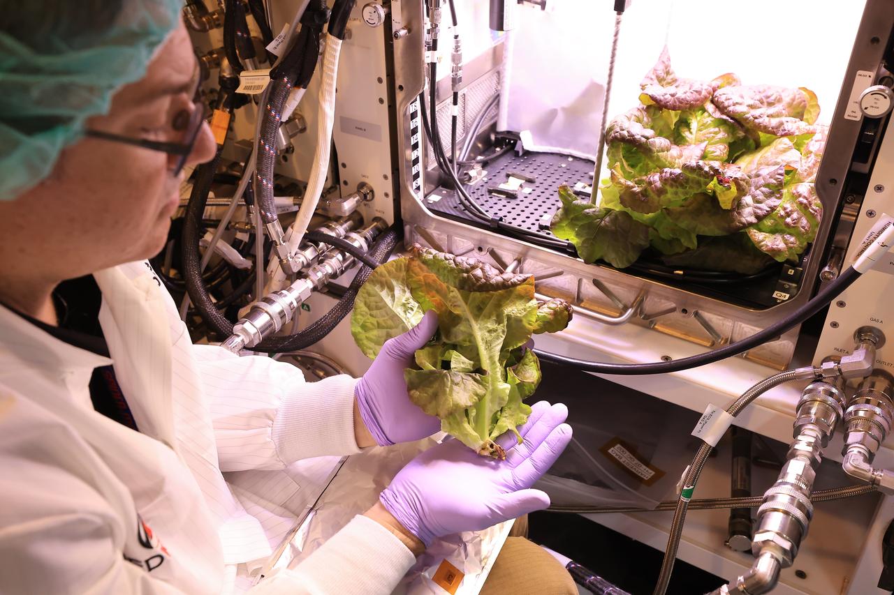
Inside a laboratory in the Space Systems Processing Facility at NASA’s Kennedy Space Center in Florida, a plant biologist harvests Outredgeous romaine lettuce growing in the Advanced Plant Habitat ground unit as the ground control portion of the Plant Habitat-07 (PH-07) experiment on Thursday, April 24, 2025. PH-07 was sent to the International Space Station on NASA’s SpaceX 31st commercial resupply services mission to study how optimal and suboptimal moisture conditions impact plant growth, nutrient content, and the plant microbiome.
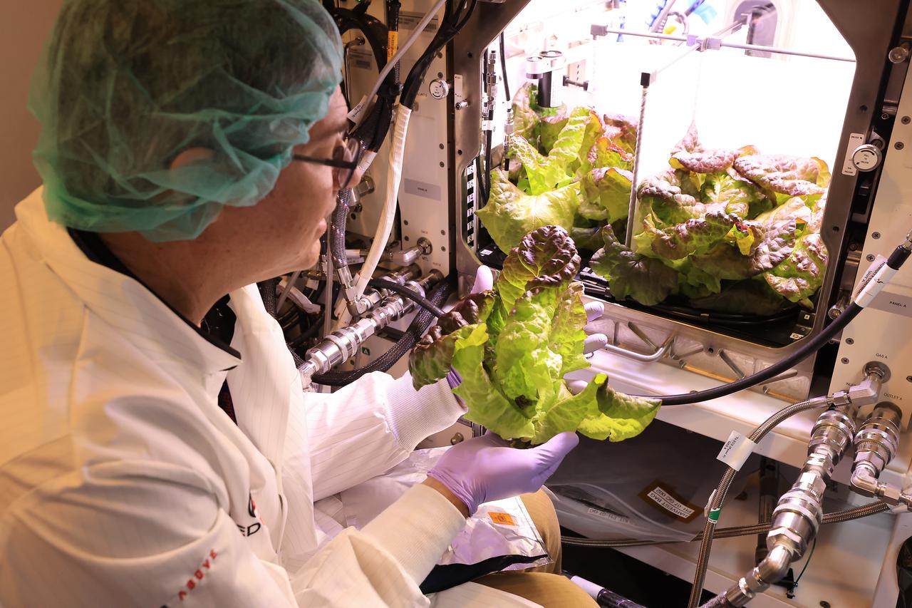
Inside a laboratory in the Space Systems Processing Facility at NASA’s Kennedy Space Center in Florida, a plant biologist harvests Outredgeous romaine lettuce growing in the Advanced Plant Habitat ground unit as the ground control portion of the Plant Habitat-07 (PH-07) experiment on Thursday, April 24, 2025. PH-07 was sent to the International Space Station on NASA’s SpaceX 31st commercial resupply services mission to study how optimal and suboptimal moisture conditions impact plant growth, nutrient content, and the plant microbiome.
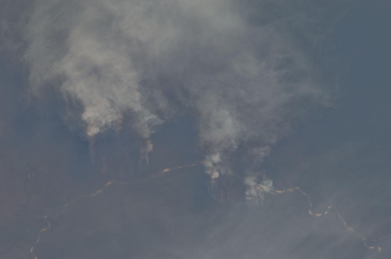
ISS029-E-008032 (17 Sept. 2011) --- Fires along the Rio Xingu, Brazil are featured in this image photographed by an Expedition 29 crew member on the International Space Station. The rain forest of South America, also known as ?Amazonia??the largest such forest on Earth?has been undergoing a continual and accelerated land use conversion process into farmlands (including pasture for livestock) since the early 1960s. This process has typically been achieved by clearing of the forest using fire ? ?slash and burn? ? followed by planting of crops. The generally infertile soils of the region make sustainable farming difficult; this drives more forest conversion into new farmland. The area of clearing can be considerable, and as the deforested regions are easily identifiable and measurable from space the rate of deforestation is likewise easy to track. This detailed photograph illustrates slash-and-burn forest clearing along the Xingu River (Rio) in the northeast of the state of Matto Grasso, Brazil. The perspective of this image allows for a striking visualization of both the horizontal position and extent of the fire lines next to the river, as well as providing a sense of the vertical structure of the smoke plumes due to the viewing angle and shadowing. Light colored areas within the river channel are sand bars, which show that the river is in its annual low-flow/ low water stage. For a sense of scale, the Xingu River channel within the view is approximately 63 kilometers long. Rivers in Amazonia are its natural highways, which may explain why the burning is occurring right next to the Xingu River, one of Amazonia?s largest. In recent years, preservation has gained traction in the region as a result of such considerations as new valuation of the ecosystem services provided by the forest, concerns about the impact of widespread burning on global climate change, and greater sensitivity to the ethnic and biological heritage of Amazonia.
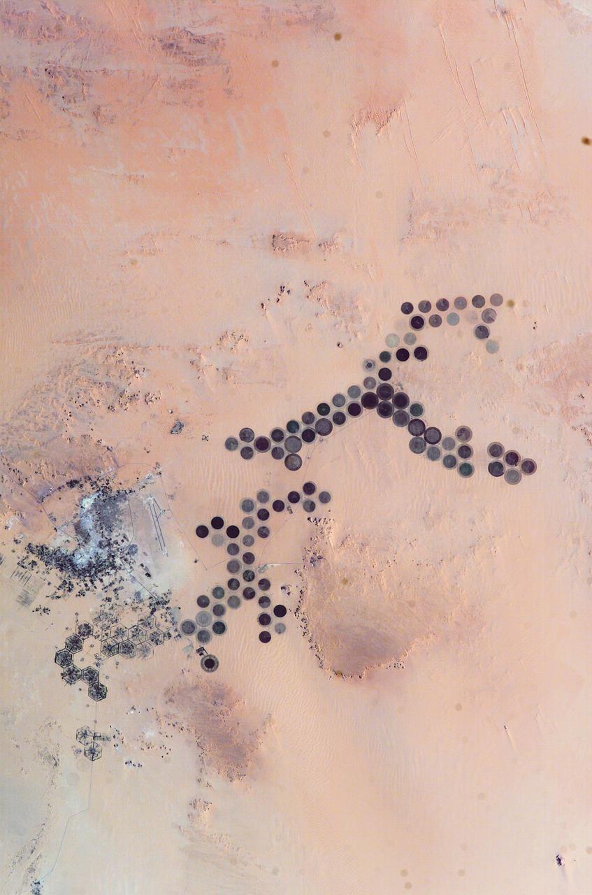
ISS010-E-05266 (28 October 2004) --- The Al Khufrah Oasis is featured in this image photographed by an Expedition 10 crewmember on the International Space Station (ISS). Green circles in the desert frequently indicate tracts of agriculture supported by center-pivot irrigation. The Al Khufrah Oasis in southeastern Libya (near the Egyptian border) is one of Libya’s largest agricultural projects, and is an easy-to-recognize landmark for orbiting crewmembers aboard the Station. The center-pivot irrigation system pumps water under pressure into a gantry or tubular arm from a central source. Anchored by a central pivot, the gantry slowly rotates over the area to be irrigated, thereby producing the circular patterns. Although the field diameters vary, these fields are approximately 0.6 mile (1 kilometer) in diameter. Darker colors indicate fields where such crops as wheat and alfalfa are grown. Lighter colors can indicate a variety of agricultural processes: fields that have been harvested recently; fields that are lying fallow; fields that have just been planted; or fields that have been taken out of production.
University of California, Santa Barbara (UCSB) student Piper Lovegreen calibrates a sensor to measure leaf chlorophyl content of vegetation at the Jack and Laura Dangermond Preserve in Santa Barbara County on March 23, 2022. Lovegreen is among the researchers working on the Surface Biology and Geology High-Frequency Time Series (SHIFT) campaign, which is jointly led by NASA's Jet Propulsion Laboratory, UCSB, and The Nature Conservancy. Operating between late February and late May 2022, SHIFT combines the ability of airborne science instruments to gather data over widespread areas with the more concentrated observations scientists conduct in the field to study the functional characteristics, health, and resilience of plant communities. The sampling and analysis done by researchers on the ground and in the ocean is intended to validate data taken by AVIRIS-NG (Airborne Visible/Infrared Imaging Spectrometer-Next Generation). The instrument, designed at JPL, is collecting spectral data of vegetation it observes during weekly flights in an aircraft over a 640-square-mile (1,656-square-kilometer) study area in Santa Barbara County and coastal Pacific waters. The campaign is a pathfinder for NASA's proposed Surface Biology and Geology (SBG) mission. SHIFT will help scientists design data collection and processing algorithms for that mission, which would launch no earlier than 2028. The SHIFT data is also intended to support the research and conservation objectives of The Nature Conservancy, which owns the Dangermond Preserve, and UCSB, which operates the Sedgwick Reserve, another nature preserve within the study area. More than 60 scientists from institutions around the U.S. have indicated they intend to use the SHIFT data in their research. https://photojournal.jpl.nasa.gov/catalog/PIA25142
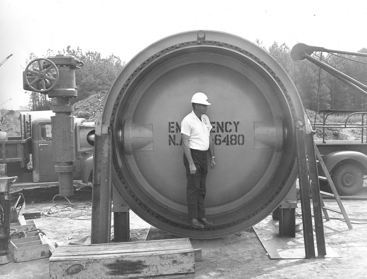
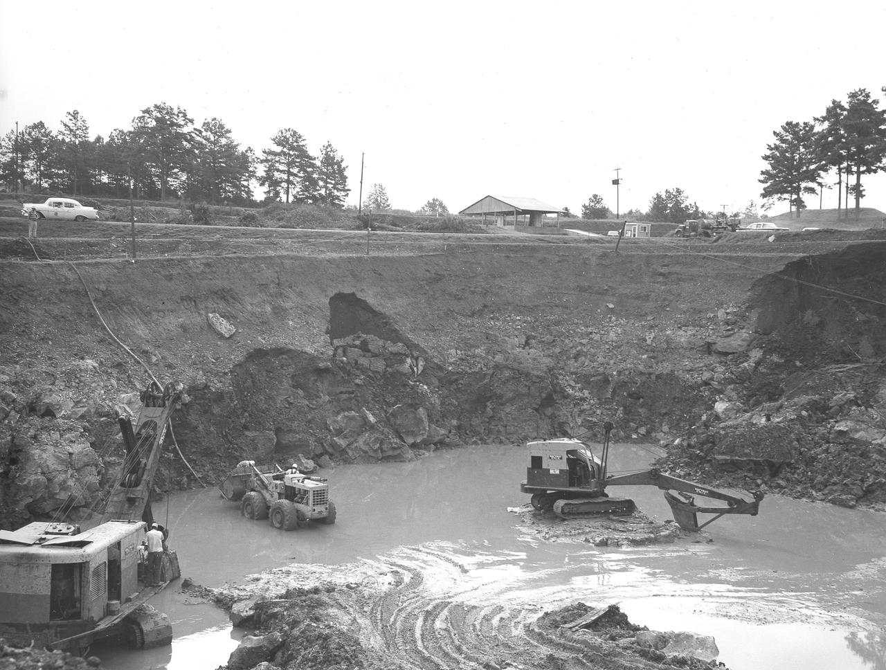
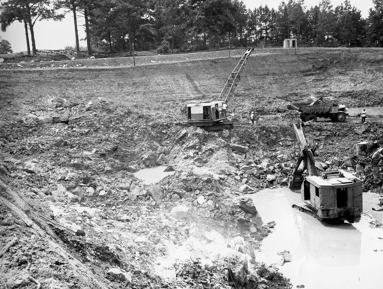
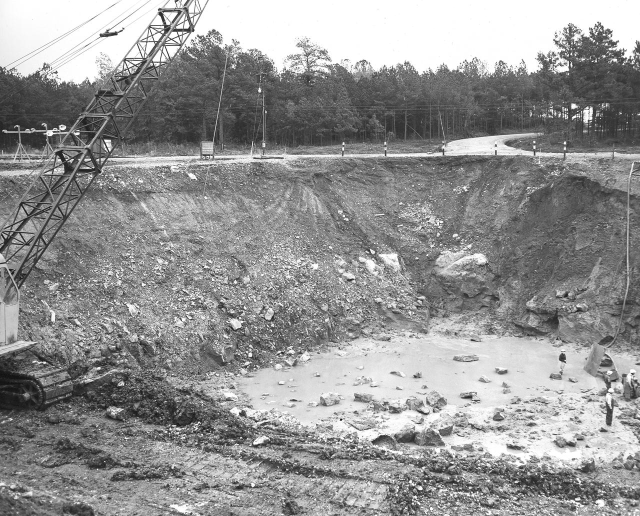
At its founding, the Marshall Space Flight Center (MSFC) inherited the Army’s Jupiter and Redstone test stands, but much larger facilities were needed for the giant stages of the Saturn V. From 1960 to 1964, the existing stands were remodeled and a sizable new test area was developed. The new comprehensive test complex for propulsion and structural dynamics was unique within the nation and the free world, and they remain so today because they were constructed with foresight to meet the future as well as on going needs. Construction of the S-IC Static test stand complex began in 1961 in the west test area of MSFC, and was completed in 1964. The S-IC static test stand was designed to develop and test the 138-ft long and 33-ft diameter Saturn V S-IC first stage, or booster stage, weighing in at 280,000 pounds. Required to hold down the brute force of a 7,500,000-pound thrust produced by 5 F-1 engines, the S-IC static test stand was designed and constructed with the strength of hundreds of tons of steel and 12,000,000 pounds of cement, planted down to bedrock 40 feet below ground level. The foundation walls, constructed with concrete and steel, are 4 feet thick. The base structure consists of four towers with 40-foot-thick walls extending upward 144 feet above ground level. The structure was topped by a crane with a 135-foot boom. With the boom in the upright position, the stand was given an overall height of 405 feet, placing it among the highest structures in Alabama at the time. In addition to the stand itself, related facilities were constructed during this time. Built northeast of the stand was a newly constructed Pump House. Its function was to provide water to the stand to prevent melting damage during testing. The water was sprayed through small holes in the stand’s 1900 ton flame deflector at the rate of 320,000 gallons per minute. In this photograph, a construction worker demonstrates the size of the massive water valve that was used in the testing cooling process.
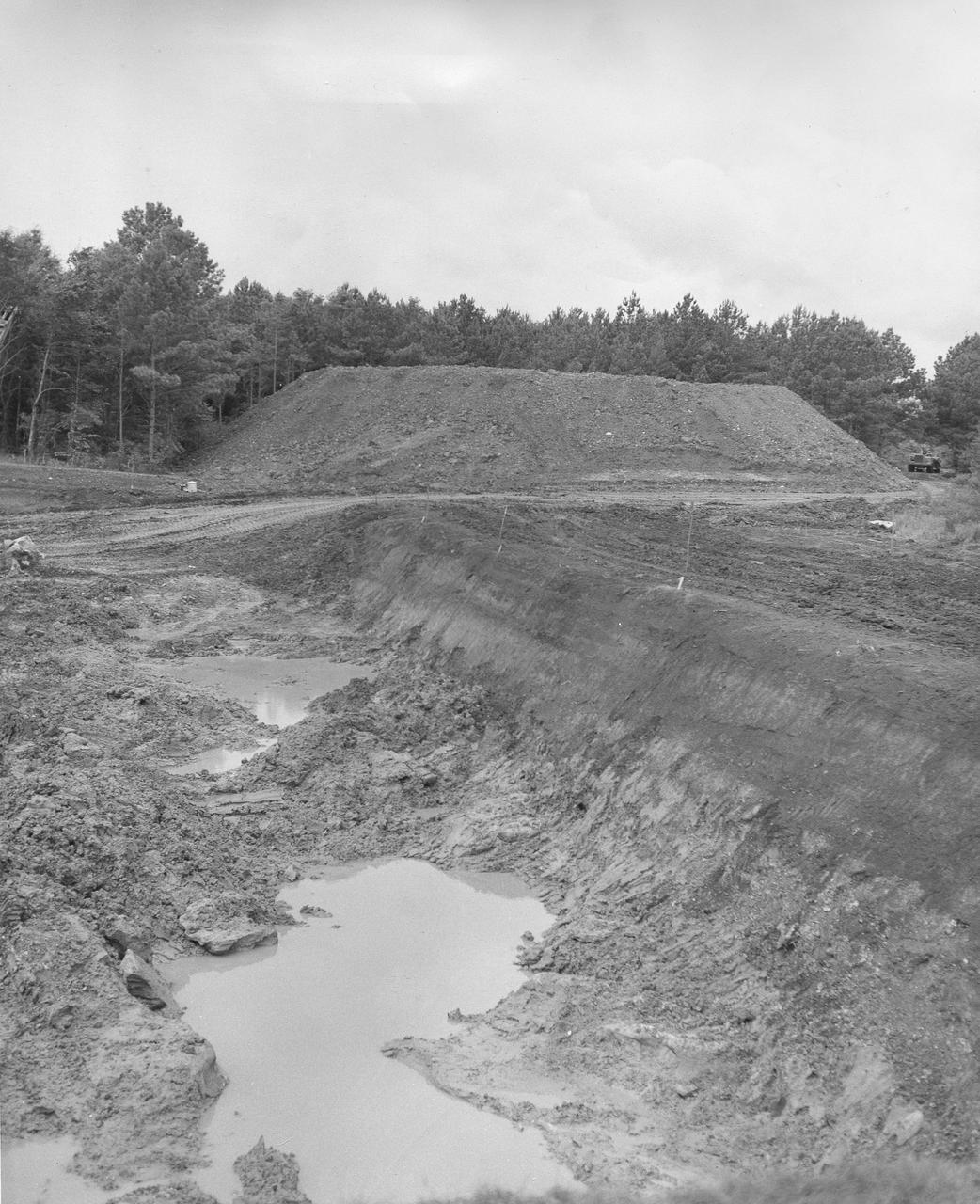
At its founding, the Marshall Space Flight Center (MSFC) inherited the Army’s Jupiter and Redstone test stands, but much larger facilities were needed for the giant stages of the Saturn V. From 1960 to 1964, the existing stands were remodeled and a sizable new test area was developed. The new comprehensive test complex for propulsion and structural dynamics was unique within the nation and the free world, and they remain so today because they were constructed with foresight to meet the future as well as on going needs. Construction of the S-IC Static test stand complex began in 1961 in the west test area of MSFC, and was completed in 1964. The S-IC static test stand was designed to develop and test the 138-ft long and 33-ft diameter Saturn V S-IC first stage, or booster stage, weighing in at 280,000 pounds. Required to hold down the brute force of a 7,500,000-pound thrust produced by 5 F-1 engines, the S-IC static test stand was designed and constructed with the strength of hundreds of tons of steel and 12,000,000 pounds of cement, planted down to bedrock 40 feet below ground level. The foundation walls, constructed with concrete and steel, are 4 feet thick. The base structure consists of four towers with 40-foot-thick walls extending upward 144 feet above ground level. The structure was topped by a crane with a 135-foot boom. With the boom in the upright position, the stand was given an overall height of 405 feet, placing it among the highest structures in Alabama at the time. In this photo, taken July 13, 1961, progress is being made with the excavation of the S-IC test stand site. During the digging, a natural spring was disturbed which caused a constant flooding problem. Pumps were used to remove the water all through the construction process and the site is still pumped today.
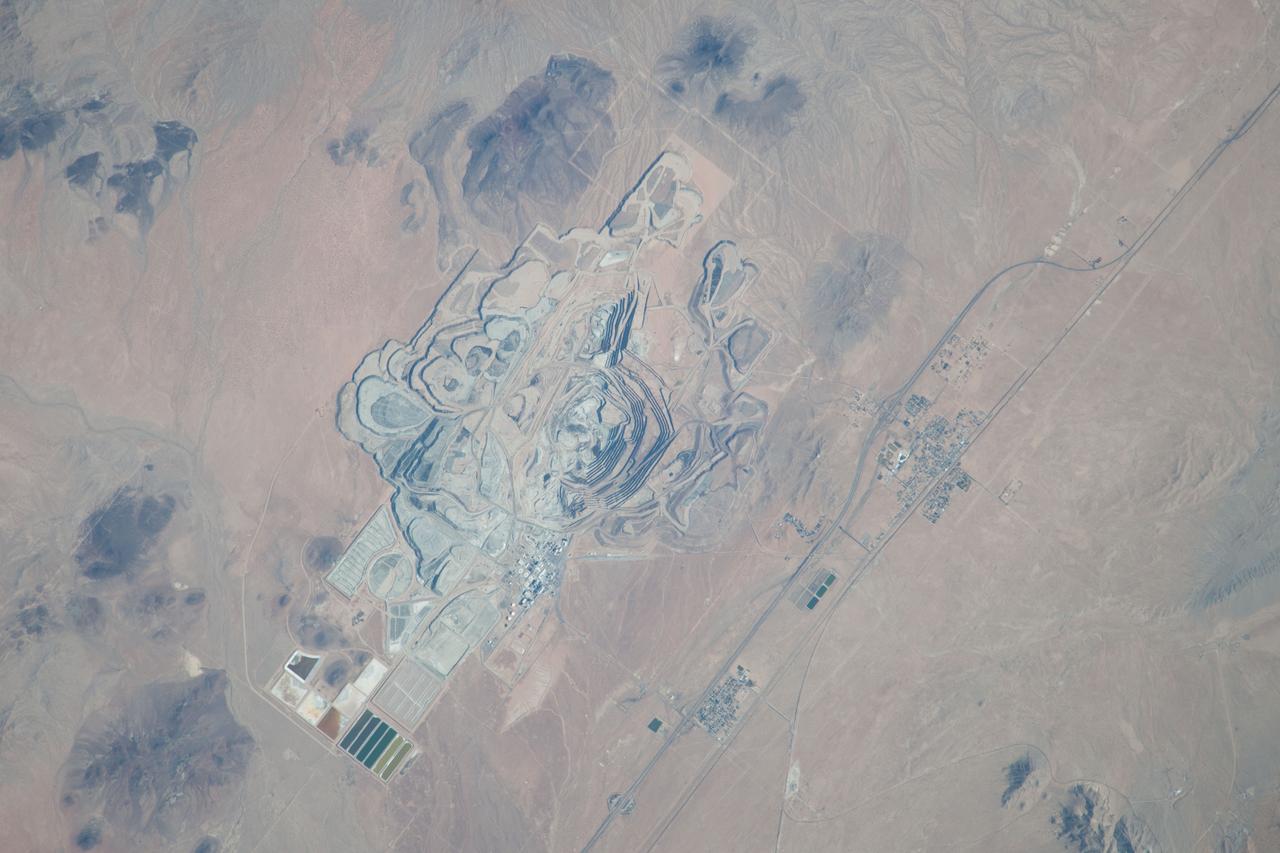
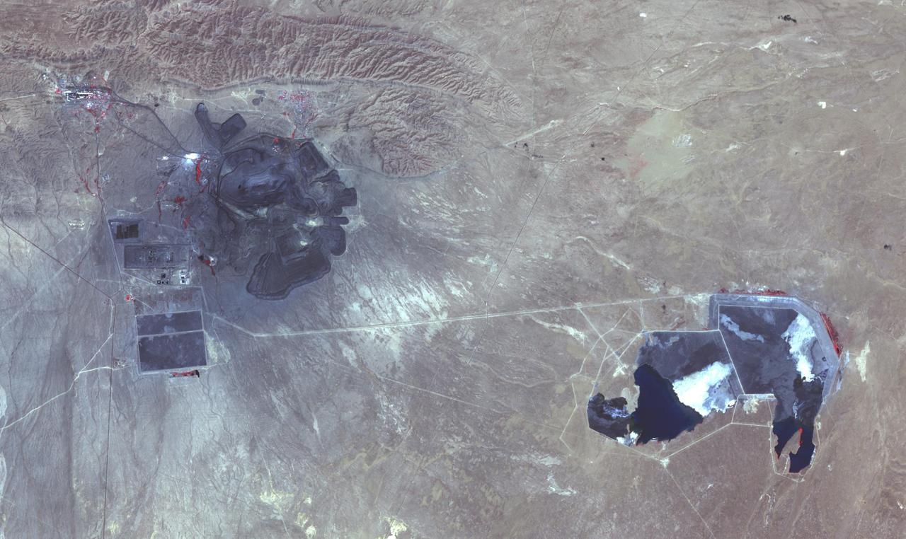
ISS037-E-022990 (30 Oct. 2013) --- This detailed image, photographed by an Expedition 37 crew member on the International Space Station, features the former US Borax mine located to the northwest of Boron, California. The mine, currently owned by the Rio Tinto Group, is the largest open-pit mine in California (covering approximately 54 square kilometers) and is among the largest borate mines in the world. Borates, chemical compounds that include the element boron (B), are important both as providers of an essential plant micronutrient, for metallurgical applications, and as components of specialized types of glass, anticorrosive coatings, fire retardants, and detergents (among other uses). Borate minerals such as borax, kernite, and ulexite are found in deposits at the Rio Tinto borax mine. The geologic setting is a structural, nonmarine basin ? a permanent shallow lake ? fed by thermal springs rich in sodium and boron that existed approximately 16 million years ago, according to scientists. The first mining claim in the area was filed in 1913, following discovery of boron-bearing nodules during well drilling. Much of the mine workings were underground until 1957, when US Borax changed to open-pit mining. The open pit is clearly visible at center; concentric benches along the pit wall are accentuated by shadows and mark successive levels of material extraction. Mine tailings are visible as stacked terraces along the northern boundary of the mine. Ore processing facilities occupy a relatively small percentage of the mine area, and are located directly to the west of the open pit. The Rio Tinto mine is one of the Earth?s richest borate deposits; together with mines in Argentina, they produce almost 40 percent of the world?s supply of industrial borate minerals.
At its founding, the Marshall Space Flight Center (MSFC) inherited the Army’s Jupiter and Redstone test stands, but much larger facilities were needed for the giant stages of the Saturn V. From 1960 to 1964, the existing stands were remodeled and a sizable new test area was developed. The new comprehensive test complex for propulsion and structural dynamics was unique within the nation and the free world, and they remain so today because they were constructed with foresight to meet the future as well as on going needs. Construction of the S-IC Static test stand complex began in 1961 in the west test area of MSFC, and was completed in 1964. The S-IC static test stand was designed to develop and test the 138-ft long and 33-ft diameter Saturn V S-IC first stage, or booster stage, weighing in at 280,000 pounds. Required to hold down the brute force of a 7,500,000-pound thrust produced by 5 F-1 engines, the S-IC static test stand was designed and constructed with the strength of hundreds of tons of steel and 12,000,000 pounds of cement, planted down to bedrock 40 feet below ground level. The foundation walls, constructed with concrete and steel, are 4 feet thick. The base structure consists of four towers with 40-foot-thick walls extending upward 144 feet above ground level. The structure was topped by a crane with a 135-foot boom. With the boom in the upright position, the stand was given an overall height of 405 feet, placing it among the highest structures in Alabama at the time. This photo shows the construction progress of the test stand as of August 14, 1961. Water gushing in from the disturbance of a natural spring contributed to constant water problems during the construction process. It was necessary to pump water from the site on a daily basis and is still pumped from the site today. The equipment is partially submerged in the water emerging from the spring.
At its founding, the Marshall Space Flight Center (MSFC) inherited the Army’s Jupiter and Redstone test stands, but much larger facilities were needed for the giant stages of the Saturn V. From 1960 to 1964, the existing stands were remodeled and a sizable new test area was developed. The new comprehensive test complex for propulsion and structural dynamics was unique within the nation and the free world, and they remain so today because they were constructed with foresight to meet the future as well as on going needs. Construction of the S-IC Static test stand complex began in 1961 in the west test area of MSFC, and was completed in 1964. The S-IC static test stand was designed to develop and test the 138-ft long and 33-ft diameter Saturn V S-IC first stage, or booster stage, weighing in at 280,000 pounds. Required to hold down the brute force of a 7,500,000-pound thrust produced by 5 F-1 engines, the S-IC static test stand was designed and constructed with the strength of hundreds of tons of steel and 12,000,000 pounds of cement, planted down to bedrock 40 feet below ground level. The foundation walls, constructed with concrete and steel, are 4 feet thick. The base structure consists of four towers with 40-foot-thick walls extending upward 144 feet above ground level. The structure was topped by a crane with a 135-foot boom. With the boom in the upright position, the stand was given an overall height of 405 feet, placing it among the highest structures in Alabama at the time. In this photograph taken on August 5th, 1961, a back hoe is nearly submerged in water in the test stand site. During the initial digging, the disturbance of a natural spring contributed to constant water problems during the construction process. It was necessary to pump the water from the site on a daily basis and is still pumped from the site today.
At its founding, the Marshall Space Flight Center (MSFC) inherited the Army’s Jupiter and Redstone test stands, but much larger facilities were needed for the giant stages of the Saturn V. From 1960 to 1964, the existing stands were remodeled and a sizable new test area was developed. The new comprehensive test complex for propulsion and structural dynamics was unique within the nation and the free world, and they remain so today because they were constructed with foresight to meet the future as well as on going needs. Construction of the S-IC Static test stand complex began in 1961 in the west test area of MSFC, and was completed in 1964. The S-IC static test stand was designed to develop and test the 138-ft long and 33-ft diameter Saturn V S-IC first stage, or booster stage, weighing in at 280,000 pounds. Required to hold down the brute force of a 7,500,000-pound thrust produced by 5 F-1 engines, the S-IC static test stand was designed and constructed with the strength of hundreds of tons of steel and 12,000,000 pounds of cement, planted down to bedrock 40 feet below ground level. The foundation walls, constructed with concrete and steel, are 4 feet thick. The base structure consists of four towers with 40-foot-thick walls extending upward 144 feet above ground level. The structure was topped by a crane with a 135-foot boom. With the boom in the upright position, the stand was given an overall height of 405 feet, placing it among the highest structures in Alabama at the time. In addition to the S-IC test stand, related facilities were built during this time. Built to the north of the massive S-IC test stand, was the F-1 Engine test stand. The F-1 test stand, a vertical engine firing test stand, 239 feet in elevation and 4,600 square feet in area at the base, was designed to assist in the development of the F-1 Engine. Capability was provided for static firing of 1.5 million pounds of thrust using liquid oxygen and kerosene. Like the S-IC stand, the foundation of the F-1 stand is keyed into the bedrock approximately 40 feet below grade. This photo, taken November 15, 1962, depicts the excavation process of the single engine F-1 stand site.
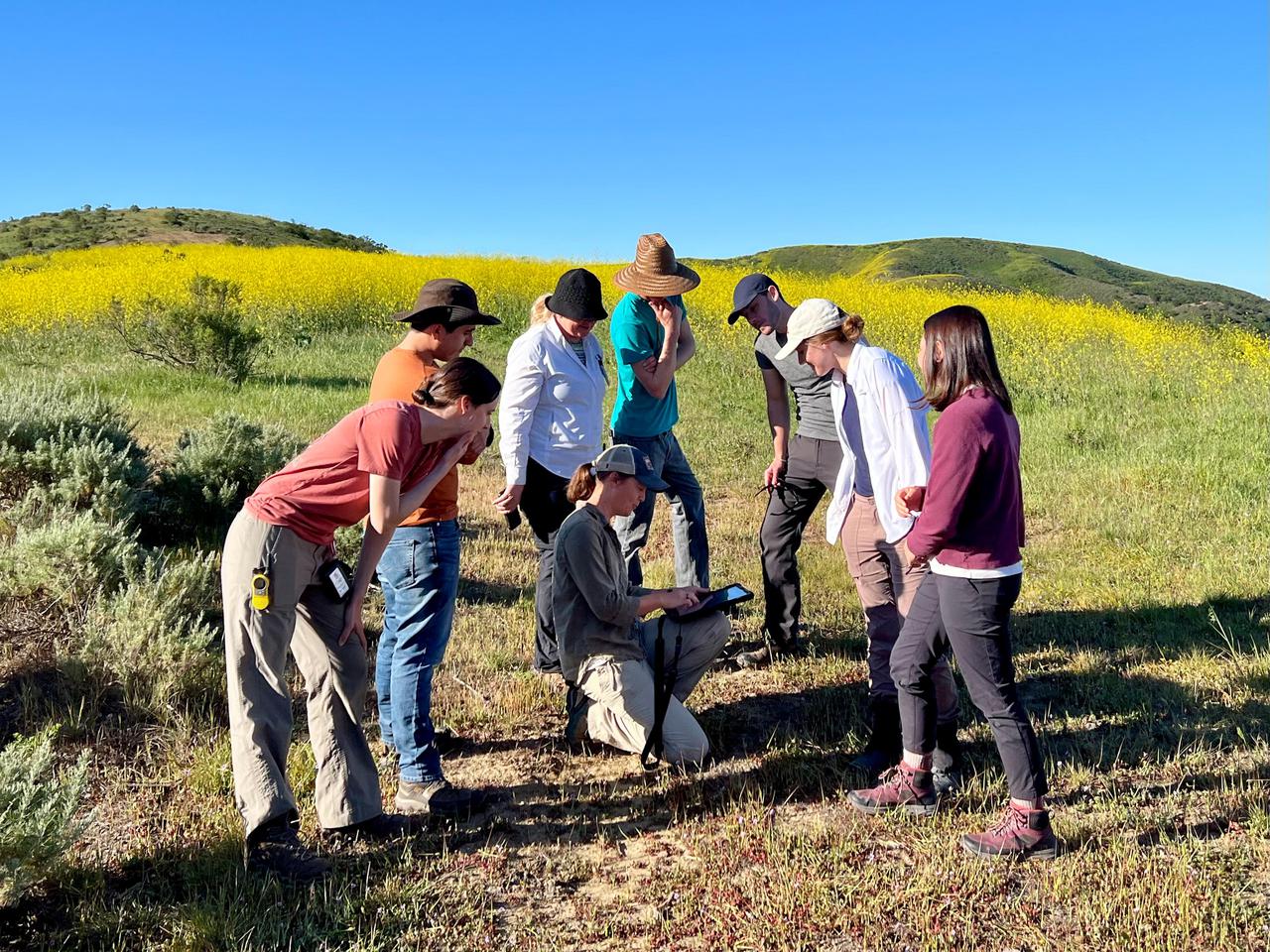
Dana Chadwick, a scientist in the water and ecosystems group at NASA's Jet Propulsion Laboratory, center, advises a field team of researchers from JPL; University of Wisconsin, Madison (UWM); University of California, Los Angeles (UCLA); University of Maryland, Baltimore County (UMBC); and University of California, Santa Barbara (UCSB) on vegetation-sampling locations at the Jack and Laura Dangermond Preserve in Santa Barbara County, California, on March 24, 2022. Chadwick and the team are working on the Surface Biology and Geology High-Frequency Time Series (SHIFT) campaign, which is jointly led by JPL, UCSB, and The Nature Conservancy. Chadwick is surrounded by, from left: Natalie Queally, a forest and wildlife ecology graduate student at UWM; Francisco Ochoa, a geography graduate student at UCLA; Petya Campbell, a research associate professor at UMBC and a research associate at NASA's Goddard Space Flight Center; Brendan Heberlein, a research intern at UWM; Renato Braghiere, a postdoctoral research scientist at JPL; Cassandra Nickles, a postdoctoral fellow at JPL; and Clare Saiki, a doctoral student at UCSB. Operating between late February and late May 2022, SHIFT combines the ability of airborne science instruments to gather data over widespread areas with the more concentrated observations scientists conduct in the field to study the functional characteristics, health, and resilience of plant communities. The sampling and analysis done by researchers on the ground and in the ocean is intended to validate data taken by AVIRIS-NG (Airborne Visible/Infrared Imaging Spectrometer-Next Generation). The instrument, designed at JPL, is collecting spectral data of vegetation it observes during weekly flights in an aircraft over a 640-square-mile (1,656-square-kilometer) study area in Santa Barbara County and coastal Pacific waters. The campaign is a pathfinder for NASA's proposed Surface Biology and Geology (SBG) mission. SHIFT will help scientists design data collection and processing algorithms for that mission, which would launch no earlier than 2028. The SHIFT data is also intended to support the research and conservation objectives of The Nature Conservancy, which owns the Dangermond Preserve, and UCSB, which operates the Sedgwick Reserve, another nature preserve within the study area. More than 60 scientists from institutions around the U.S. have indicated they intend to use the SHIFT data in their research. https://photojournal.jpl.nasa.gov/catalog/PIA25141
At its founding, the Marshall Space Flight Center (MSFC) inherited the Army’s Jupiter and Redstone test stands, but much larger facilities were needed for the giant stages of the Saturn V. From 1960 to 1964, the existing stands were remodeled and a sizable new test area was developed. The new comprehensive test complex for propulsion and structural dynamics was unique within the nation and the free world, and they remain so today because they were constructed with foresight to meet the future as well as on going needs. Construction of the S-IC Static test stand complex began in 1961 in the west test area of MSFC, and was completed in 1964. The S-IC static test stand was designed to develop and test the 138-ft long and 33-ft diameter Saturn V S-IC first stage, or booster stage, weighing in at 280,000 pounds. Required to hold down the brute force of a 7,500,000-pound thrust produced by 5 F-1 engines, the S-IC static test stand was designed and constructed with the strength of hundreds of tons of steel and 12,000,000 pounds of cement, planted down to bedrock 40 feet below ground level. The foundation walls, constructed with concrete and steel, are 4 feet thick. The base structure consists of four towers with 40-foot-thick walls extending upward 144 feet above ground level. The structure was topped by a crane with a 135-foot boom. With the boom in the upright position, the stand was given an overall height of 405 feet, placing it among the highest structures in Alabama at the time. In addition to the S-IC test stand, related facilities were built during this time. Built to the north of the massive S-IC test stand, was the F-1 Engine test stand. The F-1 test stand, a vertical engine firing test stand, 239 feet in elevation and 4,600 square feet in area at the base, was designed to assist in the development of the F-1 Engine. Capability was provided for static firing of 1.5 million pounds of thrust using liquid oxygen and kerosene. Like the S-IC stand, the foundation of the F-1 stand is keyed into the bedrock approximately 40 feet below grade. This photo, taken October 26, 1962, depicts the excavation process of the single engine F-1 stand.

ISS015-E-07649 (11 May 2007) --- Saskatchewan River Delta, Manitoba, Canada is featured in this image photographed by an Expedition 15 crewmember on the International Space Station. This image highlights a portion of the Saskatchewan River delta extending into Cedar Lake in the Province of Manitoba. The Saskatchewan River watershed extends from the Rocky Mountains of Alberta through the plains of Saskatchewan and Manitoba. The construction of the Grand Rapids Dam to the southeast (not shown) in the 1960s flooded the Cedar Lake basin. This has resulted in the formation of numerous shallow, muddy lakes and bogs (dark green to dark grey irregular areas and at upper right) in and around the Saskatchewan River delta. The level of saturation in these bogs is such that peat (semiconsolidated plant and organic matter) deposits have formed; over long periods of time and under the right geological conditions, such deposits can become coal. The velocity of Saskatchewan River water slows significantly as it enters Cedar Lake; as the flow velocity drops, entrained sediment comprised of silt, clay, sand, and gravel is deposited at the river mouth. These deposits, called alluvium by geologists, account for much of the light tan to grey materials bordering the active channels visible in the image (Saskatchewan River, Summerberry River). According to scientists, fossil-bearing amber -- originating from Late Cretaceous (approximately 65-99 million years ago) coal deposits over a thousand kilometers to the west of Cedar Lake -- is also found in the deltaic sediments. As the deposits accumulate, old channels are abandoned and new channels are formed, as the river seeks more favorable flow paths into the lake, this process (known as avulsion) builds out the river delta over time. A typical "birds foot" delta form is currently being constructed at the mouth of the Saskatchewan River (lower left). The birds foot structure is approximately 13 kilometers wide. The Mississippi River's active delta, while having the same general form, is much larger by comparison -- it is approximately 50 kilometers wide.
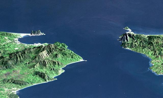
This perspective view shows the Strait of Gibraltar, which is the entrance to the Mediterranean Sea from the Atlantic Ocean. Europe (Spain) is on the left. Africa (Morocco) is on the right. The Rock of Gibraltar, administered by Great Britain, is the peninsula in the back left. The Strait of Gibraltar is the only natural gap in the topographic barriers that separate the Mediterranean Sea from the world's oceans. The Sea is about 3700 kilometers (2300 miles) long and covers about 2.5 million square kilometers (one million square miles), while the Strait is only about 13 kilometers (8 miles) wide. Sediment samples from the bottom of the Mediterranean Sea that include evaporite minerals, soils, and fossil plants show that about five million years ago the Strait was topographically blocked and the Sea had evaporated into a deep basin far lower in elevation than the oceans. Consequent changes in the world's hydrologic cycle, including effects upon ocean salinity, likely led to more ice formation in polar regions and more reflection of sunlight back to space, resulting in a cooler global climate at that time. Today, topography plays a key role in our regional climate patterns. But through Earth history, topographic change, even perhaps over areas as small as 13 kilometers across, has also affected the global climate. This image was generated from a Landsat satellite image draped over an elevation model produced by the Shuttle Radar Topography Mission (SRTM). The view is eastward with a 3-times vertical exaggeration to enhance topographic expression. Natural colors of the scene (green vegetation, blue water, brown soil, white beaches) are enhanced by image processing, inclusion of some infrared reflectance (as green) to highlight the vegetation pattern, and inclusion of shading of the elevation model to further highlight the topographic features. Landsat has been providing visible and infrared views of the Earth since 1972. SRTM elevation data matches the 30-meter (99-feet) resolution of most Landsat images and will substantially help in analyses of the large Landsat image archive. Elevation data used in this image was acquired by the Shuttle Radar Topography Mission (SRTM) aboard the Space Shuttle Endeavour, launched on February 11, 2000. http://photojournal.jpl.nasa.gov/catalog/PIA03397
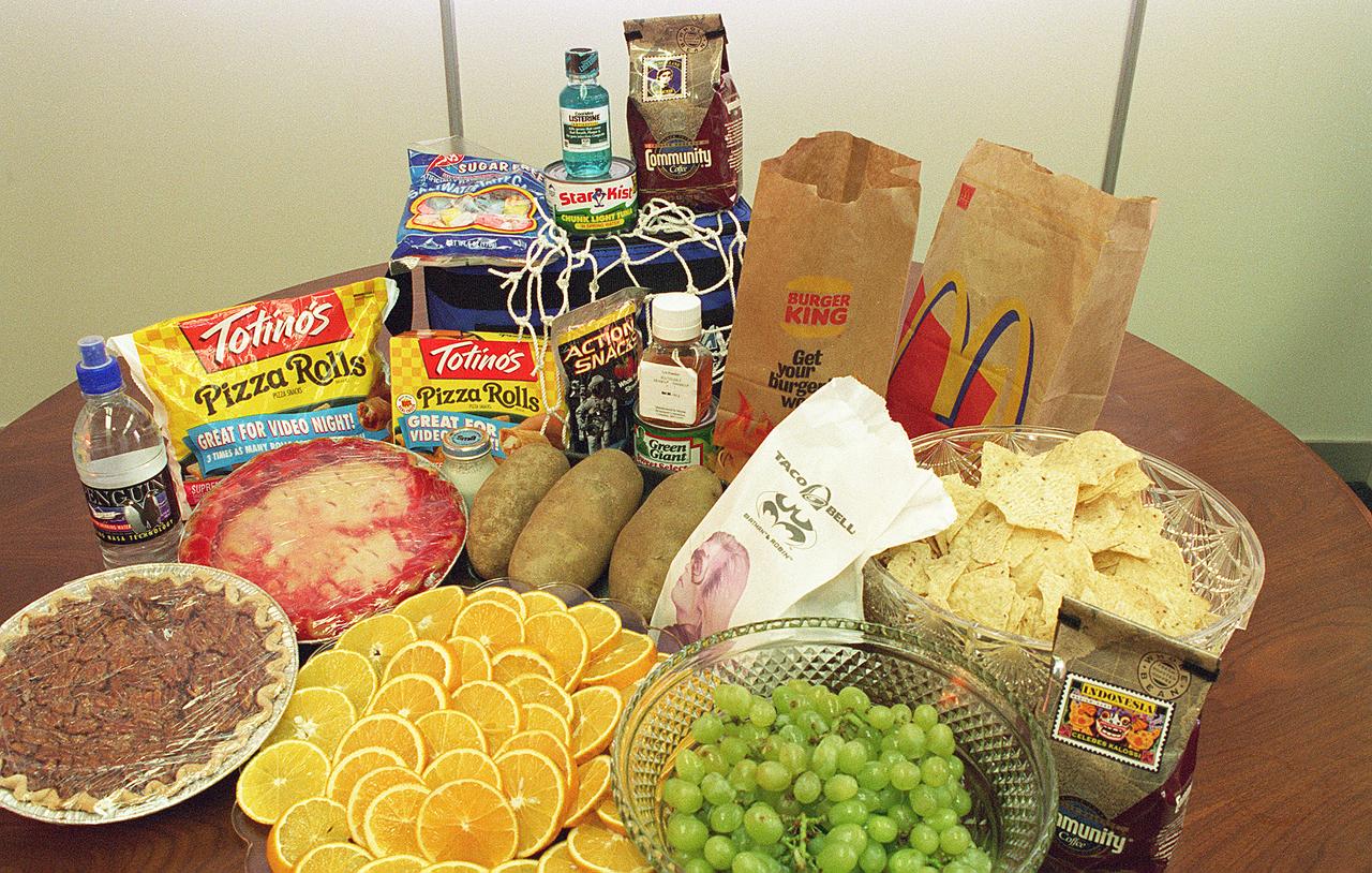
When NASA started plarning for manned space travel in 1959, the myriad challenges of sustaining life in space included a seemingly mundane but vitally important problem: How and what do you feed an astronaut? There were two main concerns: preventing food crumbs from contaminating the spacecraft's atmosphere or floating into sensitive instruments, and ensuring complete freedom from potentially catastrophic disease-producing bacteria, viruses, and toxins. To solve these concerns, NASA enlisted the help of the Pillsbury Company. Pillsbury quickly solved the first problem by coating bite-size foods to prevent crumbling. They developed the hazard analysis and critical control point (HACCP) concept to ensure against bacterial contamination. Hazard analysis is a systematic study of product, its ingredients, processing conditions, handling, storage, packing, distribution, and directions for consumer use to identify sensitive areas that might prove hazardous. Hazard analysis provides a basis for blueprinting the Critical Control Points (CCPs) to be monitored. CCPs are points in the chain from raw materials to the finished product where loss of control could result in unacceptable food safety risks. In early 1970, Pillsbury plants were following HACCP in production of food for Earthbound consumers. Pillsbury's subsequent training courses for Food and Drug Administration (FDA) personnel led to the incorporation of HACCP in the FDA's Low Acid Canned Foods Regulations, set down in the mid-1970s to ensure the safety of all canned food products in the U.S.
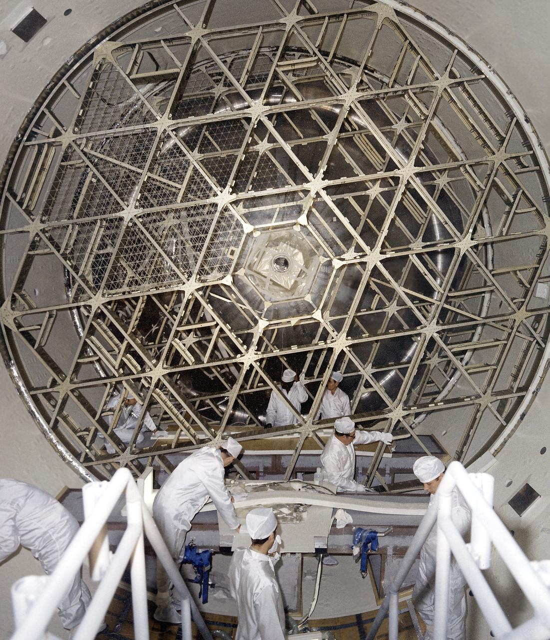
The Soil Moisture Active Passive (SMAP) mission, scheduled for launch on Jan. 29, will measure the moisture in Earth's soil with greater accuracy and higher resolution than any preceding mission, producing a global map of soil moisture every three days. Here are five quick facts about the spacecraft and what it studies. 1. Soil moisture is a tiny fraction of water with a big punch. Only 0.001 percent of Earth's total water is lodged in the top few feet of soil. That tiny percentage, however, affects all living things on land and plays an important role in moving water, carbon and heat between land and atmosphere. 2. Soil moisture can compound water risks. A flood follows a heavy rainfall -- but only if the ground cannot soak up the rain. Waterlogged soil makes a region more flood-prone. Going to the opposite extreme, a drought can parch soil to such an extent that plants are unable to grow even after a few rains have fallen. Knowing soil moisture allows hydrologists to make better decisions related to the risk of flooding and drought, such as how much water to retain in reservoirs. 3. Soil moisture controls the on-off switch for carbon dioxide cleanup. The world's vast northern forests remove carbon dioxide from the air as they grow, helping to clean up our emissions from burning fossil fuels. But when the ground freezes, that process switches off. Carbon dioxide builds up in the atmosphere until the ground thaws in the spring and plants begin growing again. Knowing where and for how long the ground is frozen or thawed is an important part of understanding the role of the northern forests in reducing greenhouse warming. SMAP will map frozen and thawed soils north of 45 degrees north latitude (about the latitude of Minneapolis), around the globe. 4. SMAP is a twofer. The spacecraft's radiometer produces an accurate reading of how much moisture is in the top two inches (five centimeters) of soil, but it has low spatial resolution, that is, one measurement covers a large area. A radar instrument produces an image with higher spatial resolution, but it can't measure soil moisture as accurately as a radiometer. Through sophisticated data processing, SMAP combines observations from the two instruments into a very accurate measurement with high spatial resolution. 5. SMAP has a huge, folding, spinning antenna. At 19 feet 8 inches (6 meters) in diameter, SMAP's rotating mesh antenna dwarfs the size of the instruments and spacecraft and is the largest rotating antenna of its kind that NASA has yet deployed. But the entire dish furls into a cylinder one foot (diameter) by four feet (30 by 120 centimeters) to fit inside the rocket’s fairing for launch, and it weighs only 128 pounds (about 58 kilograms). For more information about SMAP, see: <a href="http://smap.jpl.nasa.gov/" rel="nofollow">smap.jpl.nasa.gov/</a> <a href="http://www.nasa.gov/smap/" rel="nofollow">www.nasa.gov/smap/</a> <b><a href="http://www.nasa.gov/audience/formedia/features/MP_Photo_Guidelines.html" rel="nofollow">NASA image use policy.</a></b> <b><a href="http://www.nasa.gov/centers/goddard/home/index.html" rel="nofollow">NASA Goddard Space Flight Center</a></b> enables NASA’s mission through four scientific endeavors: Earth Science, Heliophysics, Solar System Exploration, and Astrophysics. Goddard plays a leading role in NASA’s accomplishments by contributing compelling scientific knowledge to advance the Agency’s mission. <b>Follow us on <a href="http://twitter.com/NASAGoddardPix" rel="nofollow">Twitter</a></b> <b>Like us on <a href="http://www.facebook.com/pages/Greenbelt-MD/NASA-Goddard/395013845897?ref=tsd" rel="nofollow">Facebook</a></b> <b>Find us on <a href="http://instagram.com/nasagoddard?vm=grid" rel="nofollow">Instagram</a></b>