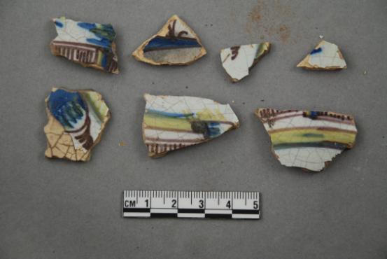
Artifacts retrieved from the ruins of Elliot Plantation on NASA’s Kennedy Space Center in Florida include Spanish majolica fragments, likely produced between the 1730s to the 1750s and imported to the plantation from England. Ceramic fragments of majolica, delftware, and other high-status domestic wares were retrieved from ruins determined to be the dwelling of the plantation overseer. The ruins of Elliot Plantation date from the 1760s and represent the largest, earliest, and southernmost British period sugar plantation in the U.S., as well as one of the most intact and best examples of a completely preserved enslaved landscape. In interagency cooperation between the National Park Service, the U.S. Fish and Wildlife Service, and NASA, and with the assistance of volunteers from the Indian River Anthropological Society, and historic preservation offices of Brevard and Volusia counties, approximately 200 shovel tests and 20 excavation units were completed in three areas of the plantation complex from 2008 to 2009.
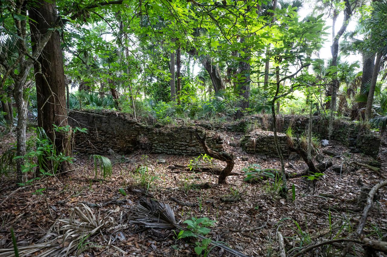
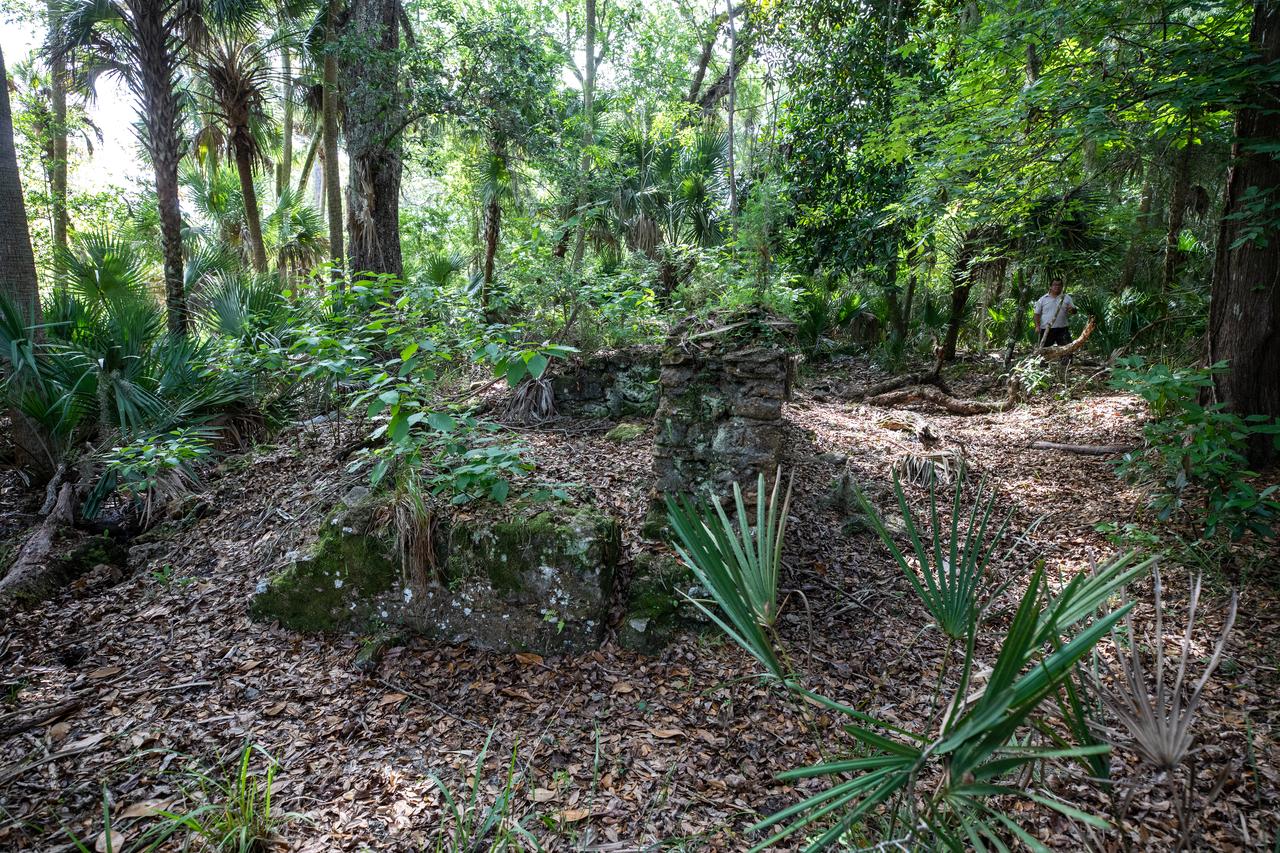
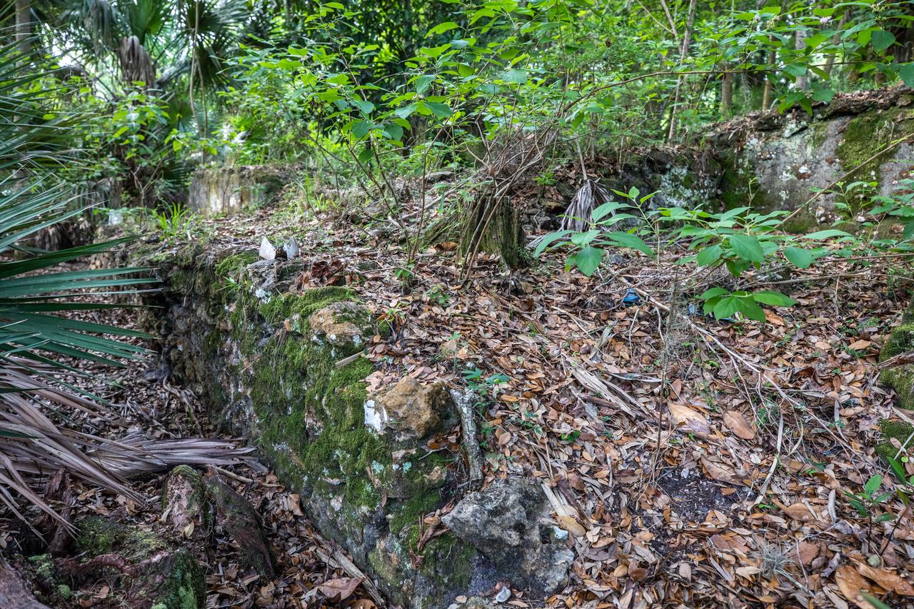
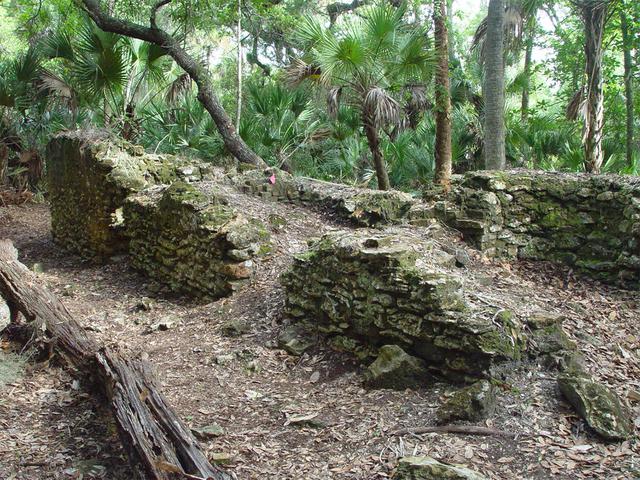
Archeological ruins of the Elliot Plantation sugar mill are revealed through the oak hammock at NASA’s Kennedy Space Center in Florida on May 26, 2022. The plantation’s enslaved community built the sugar mill structure, or sugar train, where sugar cane juice would be boiled during processing in graduated copper kettles until the liquid reduced into a thick syrup. The ruins of Elliot Plantation date from the 1760s and represent the largest, earliest, and southernmost British period sugar plantation in the U.S., as well as one of the most intact and best examples of a completely preserved enslaved landscape. The archeological site is managed through interagency cooperation between the National Park Service, the U.S. Fish and Wildlife Service, and NASA.
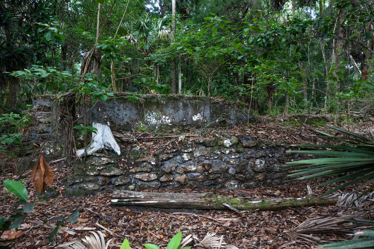
Archeological ruins of the Elliot Plantation sugar mill are revealed through the oak hammock at NASA’s Kennedy Space Center in Florida on May 26, 2022. The plantation’s enslaved community built the sugar mill structure, or sugar train, where sugar cane juice would be boiled during processing in graduated copper kettles until the liquid reduced into a thick syrup. The ruins of Elliot Plantation date from the 1760s and represent the largest, earliest, and southernmost British period sugar plantation in the U.S., as well as one of the most intact and best examples of a completely preserved enslaved landscape. The archeological site is managed through interagency cooperation between the National Park Service, the U.S. Fish and Wildlife Service, and NASA.
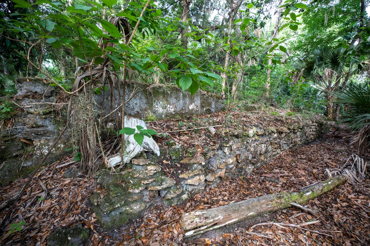
Archeological ruins of the Elliot Plantation sugar mill are revealed through the oak hammock at NASA’s Kennedy Space Center in Florida on May 26, 2022. The plantation’s enslaved community built the sugar mill structure, or sugar train, where sugar cane juice would be boiled during processing in graduated copper kettles until the liquid reduced into a thick syrup. The ruins of Elliot Plantation date from the 1760s and represent the largest, earliest, and southernmost British period sugar plantation in the U.S., as well as one of the most intact and best examples of a completely preserved enslaved landscape. The archeological site is managed through interagency cooperation between the National Park Service, the U.S. Fish and Wildlife Service, and NASA.
Archeological ruins of the Elliot Plantation sugar mill are revealed through the oak hammock at NASA’s Kennedy Space Center in Florida on May 26, 2022. The plantation’s enslaved community built the sugar mill structure, or sugar train, where sugar cane juice would be boiled during processing in graduated copper kettles until the liquid reduced into a thick syrup. The ruins of Elliot Plantation date from the 1760s and represent the largest, earliest, and southernmost British period sugar plantation in the U.S., as well as one of the most intact and best examples of a completely preserved enslaved landscape. The archeological site is managed through interagency cooperation between the National Park Service, the U.S. Fish and Wildlife Service, and NASA.
Archeological ruins of the Elliot Plantation sugar mill are revealed through the oak hammock at NASA’s Kennedy Space Center in Florida on May 26, 2022. The plantation’s enslaved community built the sugar mill structure, or sugar train, where sugar cane juice would be boiled during processing in graduated copper kettles until the liquid reduced into a thick syrup. The ruins of Elliot Plantation date from the 1760s and represent the largest, earliest, and southernmost British period sugar plantation in the U.S., as well as one of the most intact and best examples of a completely preserved enslaved landscape. The archeological site is managed through interagency cooperation between the National Park Service, the U.S. Fish and Wildlife Service, and NASA.
Archeological ruins of the Elliot Plantation sugar mill are revealed through the oak hammock at NASA’s Kennedy Space Center in Florida on May 26, 2022. The plantation’s enslaved community built the sugar mill structure, or sugar train, where sugar cane juice would be boiled during processing in graduated copper kettles until the liquid reduced into a thick syrup. The ruins of Elliot Plantation date from the 1760s and represent the largest, earliest, and southernmost British period sugar plantation in the U.S., as well as one of the most intact and best examples of a completely preserved enslaved landscape. The archeological site is managed through interagency cooperation between the National Park Service, the U.S. Fish and Wildlife Service, and NASA.
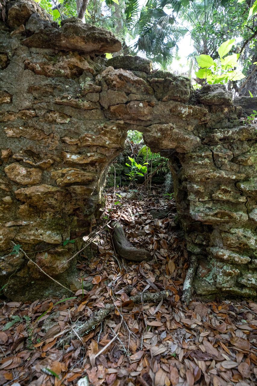
Archeological ruins of Elliot Plantation are revealed through the oak hammock on NASA’s Kennedy Space Center in Florida in 2008. Pictured is a structure composed of coquina blocks from a hearth of a large dwelling, determined to be that of the plantation overseer. The use of coquina is consistent with high-status building materials of the period. The ruins of Elliot Plantation date from the 1760s and represent the largest, earliest, and southernmost British period sugar plantation in the U.S., as well as one of the most intact and best examples of a completely preserved enslaved landscape. In interagency cooperation between the National Park Service, the U.S. Fish and Wildlife Service, and NASA, and with the assistance of volunteers from the Indian River Anthropological Society, and historic preservation offices of Brevard and Volusia counties, approximately 200 shovel tests and 20 excavation units were completed in three areas of the plantation complex from 2008 to 2009.
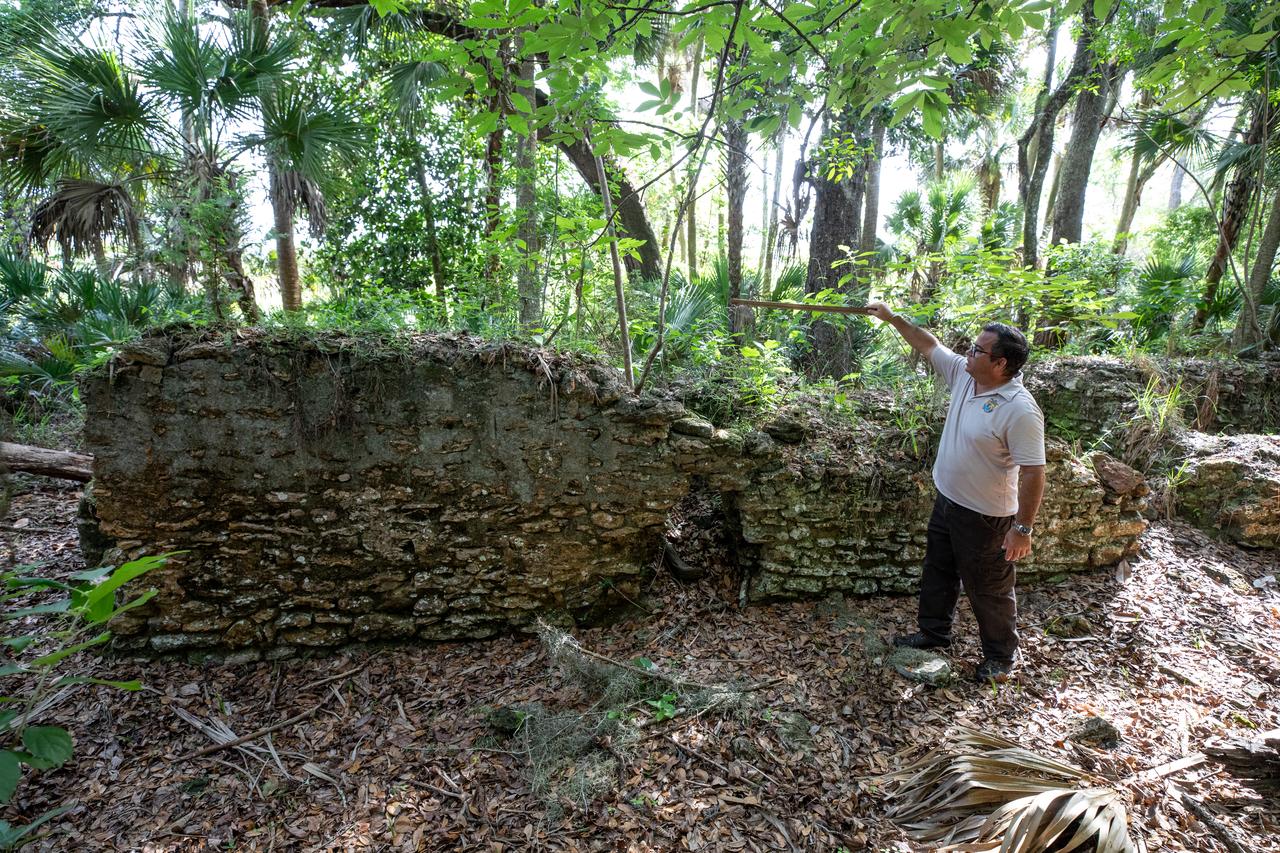
Near the archeological ruins of the Elliot Plantation sugar mill at NASA’s Kennedy Space Center in Florida, Michael Legare, of the U.S. Fish and Wildlife Service, recreates the original wall height of the structure on May 26, 2022. The plantation’s enslaved community built the sugar mill structure, or sugar train, where sugar cane juice would be boiled during processing in graduated copper kettles until the liquid reduced into a thick syrup. The ruins of Elliot Plantation date from the 1760s and represent the largest, earliest, and southernmost British period sugar plantation in the U.S., as well as one of the most intact and best examples of a completely preserved enslaved landscape. The archeological site is managed through interagency cooperation between the National Park Service, the U.S. Fish and Wildlife Service, and NASA.
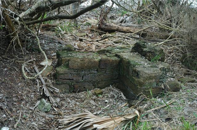
Archeological ruins of the Elliot Plantation sugar factory are revealed through the oak hammock on NASA’s Kennedy Space Center in Florida in 2008. The sugar factory structure, or sugar train, was built from fieldstone and is where sugar cane juice would be boiled during processing in graduated copper kettles until the liquid reduced into a thick syrup. The ruins of Elliot Plantation date from the 1760s and represent the largest, earliest, and southernmost British period sugar plantation in the U.S., as well as one of the most intact and best examples of a completely preserved enslaved landscape. In interagency cooperation between the National Park Service, the U.S. Fish and Wildlife Service, and NASA, and with the assistance of volunteers from the Indian River Anthropological Society, and historic preservation offices of Brevard and Volusia counties, approximately 200 shovel tests and 20 excavation units were completed in three areas of the plantation complex from 2008 to 2009.
Michael Legare, of the U.S. Fish and Wildlife Service, stands near the archeological ruins of the Elliot Plantation sugar mill at NASA’s Kennedy Space Center in Florida on May 26, 2022. The plantation’s enslaved community built the sugar mill structure, or sugar train, where sugar cane juice would be boiled during processing in graduated copper kettles until the liquid reduced into a thick syrup. The ruins of Elliot Plantation date from the 1760s and represent the largest, earliest, and southernmost British period sugar plantation in the U.S., as well as one of the most intact and best examples of a completely preserved enslaved landscape. The archeological site is managed through interagency cooperation between the National Park Service, the U.S. Fish and Wildlife Service, and NASA.
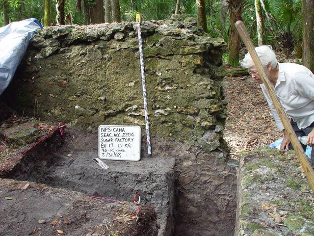
Preservationist Dot Moore views the ruins of Elliot Plantation sugar factory during an excavation in 2008 on NASA’s Kennedy Space Center. The sugar factory structure, or sugar train, was built from fieldstone and is where sugar cane juice would be boiled during processing in graduated copper kettles until the liquid reduced into a thick syrup. The ruins of Elliot Plantation date from the 1760s and represent the largest, earliest, and southernmost British period sugar plantation in the U.S., as well as one of the most intact and best examples of a completely preserved enslaved landscape. In interagency cooperation between the National Park Service, the U.S. Fish and Wildlife Service, and NASA, and with the assistance of volunteers from the Indian River Anthropological Society, and historic preservation offices of Brevard and Volusia counties, approximately 200 shovel tests and 20 excavation units were completed in three areas of the plantation complex from 2008 to 2009.
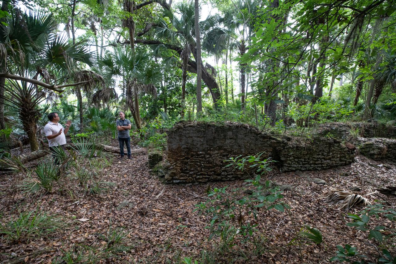
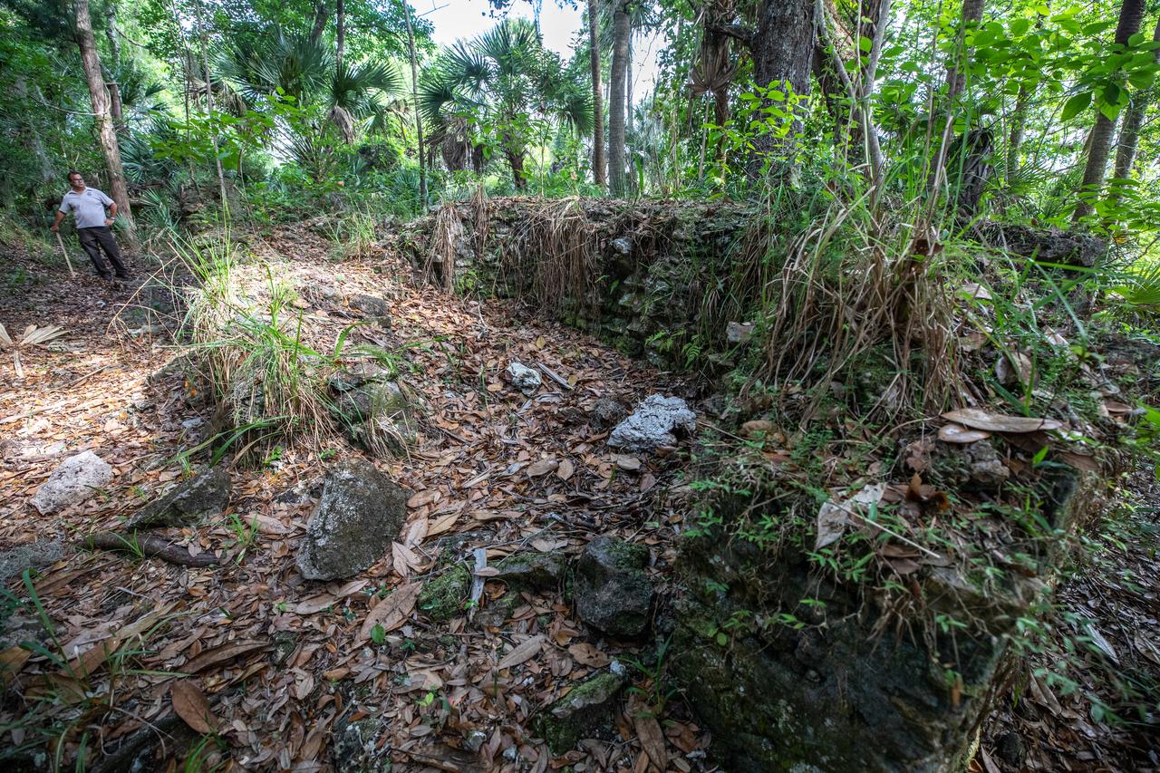
Members of U.S. Fish and Wildlife Service and NASA Communications visit the archeological ruins of the Elliot Plantation sugar mill at NASA’s Kennedy Space Center in Florida on May 26, 2022. The plantation’s enslaved community built the sugar mill structure, or sugar train, where sugar cane juice would be boiled during processing in graduated copper kettles until the liquid reduced into a thick syrup. The ruins of Elliot Plantation date from the 1760s and represent the largest, earliest, and southernmost British period sugar plantation in the U.S., as well as one of the most intact and best examples of a completely preserved enslaved landscape. The archeological site is managed through interagency cooperation between the National Park Service, the U.S. Fish and Wildlife Service, and NASA.
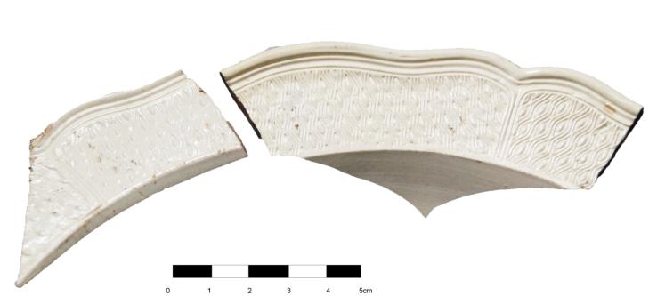
Artifacts retrieved from the ruins of Elliot Plantation on NASA’s Kennedy Space Center in Florida show high-status fine dining wares imported from 18th century England. The white salt-glazed stoneware and creamware dining wares were found scattered near a large structure, determined by archeologists to be the dwelling of the plantation overseer. The dining wares have known dates of time for manufacturing and use during the 1760s through the 1770s and helped archeologists confirm the site was from the same period. The ruins of Elliot Plantation date from the 1760s and represent the largest, earliest, and southernmost British period sugar plantation in the U.S., as well as one of the most intact and best examples of a completely preserved enslaved landscape. In interagency cooperation between the National Park Service, the U.S. Fish and Wildlife Service, and NASA, and with the assistance of volunteers from the Indian River Anthropological Society, and historic preservation offices of Brevard and Volusia counties, approximately 200 shovel tests and 20 excavation units were completed in three areas of the plantation complex from 2008 to 2009.
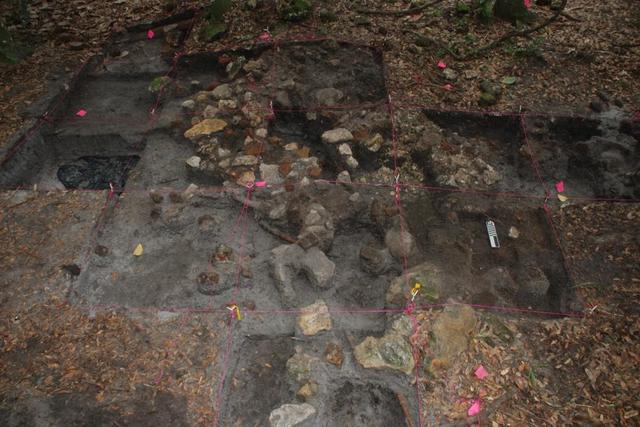
Archeological ruins of Elliot Plantation are revealed through the oak hammock on NASA’s Kennedy Space Center in Florida in 2009. Pictured is a structure composed of coquina blocks from a hearth of a large dwelling, determined to be that of the plantation overseer. The use of coquina is consistent with high-status building materials of the period. Mapped in this photo are the remnants of a chimney collapse from a detached kitchen in the overseer’s house. An enormous scatter of architectural debris, including coquina, fieldstone, brick and mortar, as well as substantial food remains, broken dishes, bottle glass, and other kitchen wares, were recovered and documented during investigations of the ruins. The ruins of Elliot Plantation date from the 1760s and represent the largest, earliest, and southernmost British period sugar plantation in the U.S., as well as one of the most intact and best examples of a completely preserved enslaved landscape. In interagency cooperation between the National Park Service, the U.S. Fish and Wildlife Service, and NASA, and with the assistance of volunteers from the Indian River Anthropological Society, and historic preservation offices of Brevard and Volusia counties, approximately 200 shovel tests and 20 excavation units were completed in three areas of the plantation complex from 2008 to 2009.
KENNEDY SPACE CENTER, FLA. - Center Director Jim Kennedy (left) and astronaut Roger Crouch talk to students at South Plantation High School in Plantation, Fla. Kennedy and Crouch are visiting the NASA Explorer School (NES) to share the vision for space exploration with the next generation. During the visit, Crouch is talking with students about our destiny as explorers, NASA's stepping stone approach to exploring Earth, the moon, Mars and beyond, how space impacts our lives, and how people and machines rely on each other in space. The Agency's NES program establishes a three-year partnership annually between NASA and 50 NASA Explorer School teams, consisting of teachers and education administrators from diverse communities nationwide. Photo credit: NASA/Cory Huston
KENNEDY SPACE CENTER, FLA. - Center Director Jim Kennedy and Hortense Burt, with the Education Office at NASA's Kennedy Space Center, greet a student at South Plantation High School in Plantation, Fla. Kennedy, Burt and other Kennedy representatives are visiting the NASA Explorer School (NES) to share the vision for space exploration with the next generation. Astronaut Roger Crouch joined the Kennedy team. During the visit, Crouch is talking with students about our destiny as explorers, NASA's stepping stone approach to exploring Earth, the moon, Mars and beyond, how space impacts our lives, and how people and machines rely on each other in space. The Agency's NES program establishes a three-year partnership annually between NASA and 50 NASA Explorer School teams, consisting of teachers and education administrators from diverse communities nationwide. Photo credit: NASA/Cory Huston
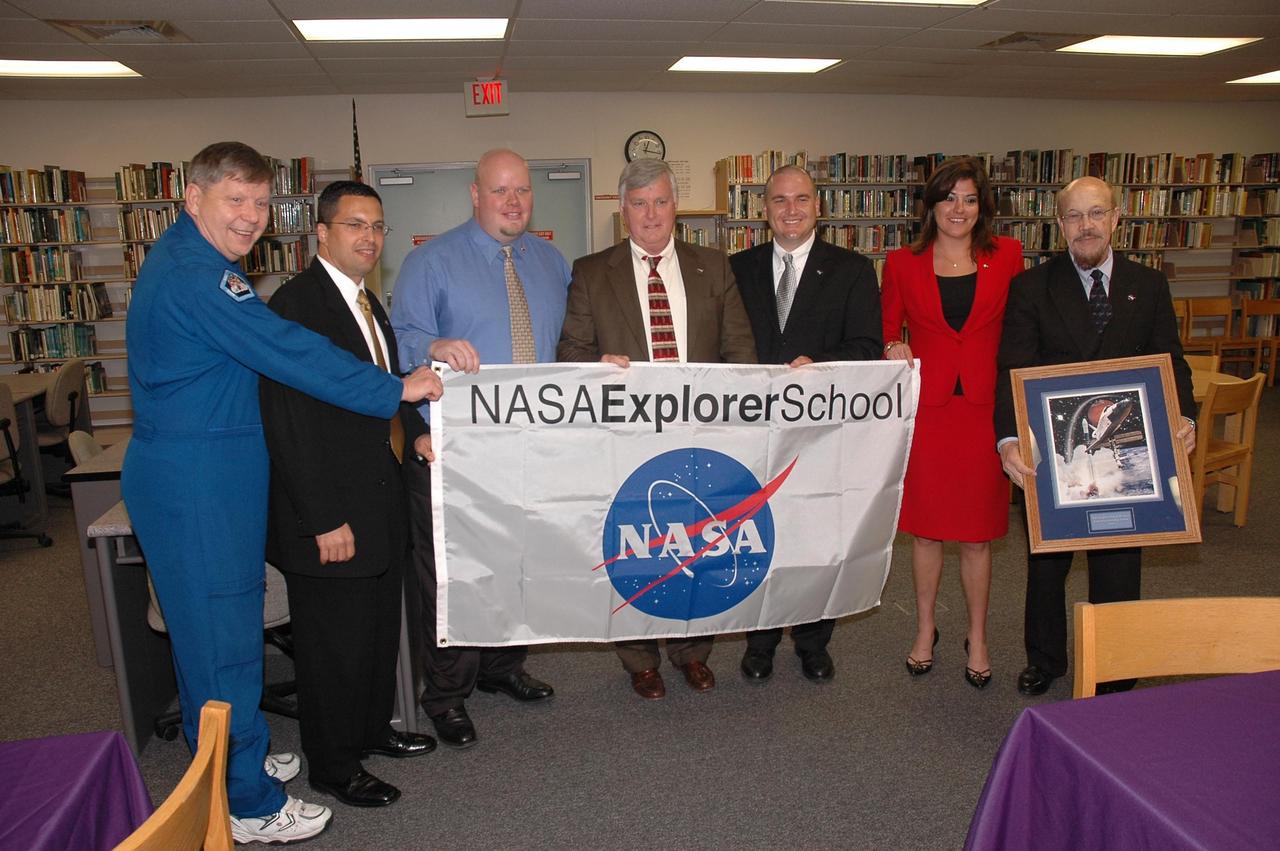
KENNEDY SPACE CENTER, FLA. - Center Director Jim Kennedy (center) and astronaut Roger Crouch (far left) present a NASA Explorer School (NES) banner to the NES team at South Plantation High School in Plantation, Fla. Kennedy, Crouch and other NASA KSC officials are visiting the school to share the vision for space exploration with the next generation. During the visit, Crouch is talking with students about our destiny as explorers, NASA's stepping stone approach to exploring Earth, the moon, Mars and beyond, how space impacts our lives, and how people and machines rely on each other in space. The Agency's NES program establishes a three-year partnership annually between NASA and 50 NASA Explorer School teams, consisting of teachers and education administrators from diverse communities nationwide. Photo credit: NASA/Cory Huston

KENNEDY SPACE CENTER, FLA. - The NASA Explorer School (NES) team at Kennedy Space Center poses with the NES team at South Plantation High School in Plantation, Fla. Center Director Jim Kennedy is fifth from the right. On the far right is Hortense Burt, with the Education Office at Kennedy. The Kennedy team, which also included astronaut Roger Couch, is visiting the school to share the vision for space exploration with the next generation. During the visit, Crouch is talking with students about our destiny as explorers, NASA's stepping stone approach to exploring Earth, the moon, Mars and beyond, how space impacts our lives, and how people and machines rely on each other in space. The Agency's NES program establishes a three-year partnership annually between NASA and 50 NASA Explorer School teams, consisting of teachers and education administrators from diverse communities nationwide. Photo credit: NASA/Cory Huston
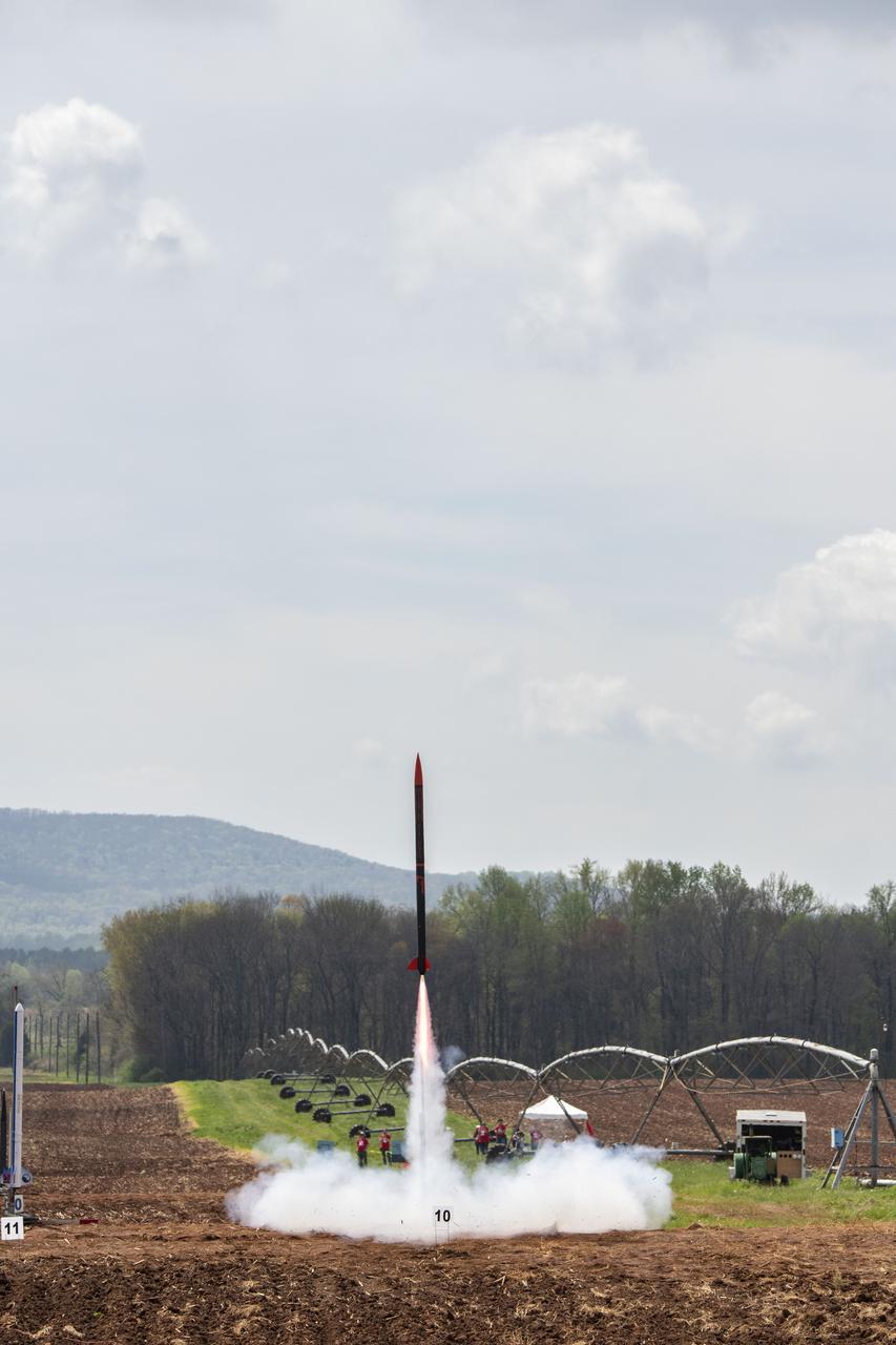
High School and College students from around the U.S. came together at Bragg Farms in Toney, Alabama for the 2019 Student Launch Initiative. The students launched their rockets to their own predetermined altitude with various payloads including remote rovers and unmanned aerial vehicles. The rocket named Zeppelin from Plantation High School in Plantation, Florida, roars off of the pad at launch day for the 2018-2019 Student Launch competition.
The southwestern border of Brunei with Sarawak, Malaysia is strikingly apparent due to differences in land use practice. On the Malaysian side, a spider web of small roads indicates intensive land use: in this case clearing of the forest for palm oil plantations. On the Brunei side, the virgin forest is preserved, with few if any roads cutting through the forest. The image was acquired September 10, 2012, covers an area of 38 by 38 km, and is located at 4.2 degrees north, 114.4 degrees east. https://photojournal.jpl.nasa.gov/catalog/PIA22034

STS073-745-055 (2 November 1995) --- This photograph in color infrared highlights the different vegetation zones on the island of Maui, Hawaii. The dark red tropical forests live on the steep volcanic slopes on the north side of the island, and the fertile lowlands support large sugar cane plantations, which are the red and black checkered pattern. The Wailuku and Kahului area near the center on the north shore of the island was formerly a whaling center. Much of the eastern part of the island is Haleakala National Park, including the spectacular Haleakala Crater (under clouds).

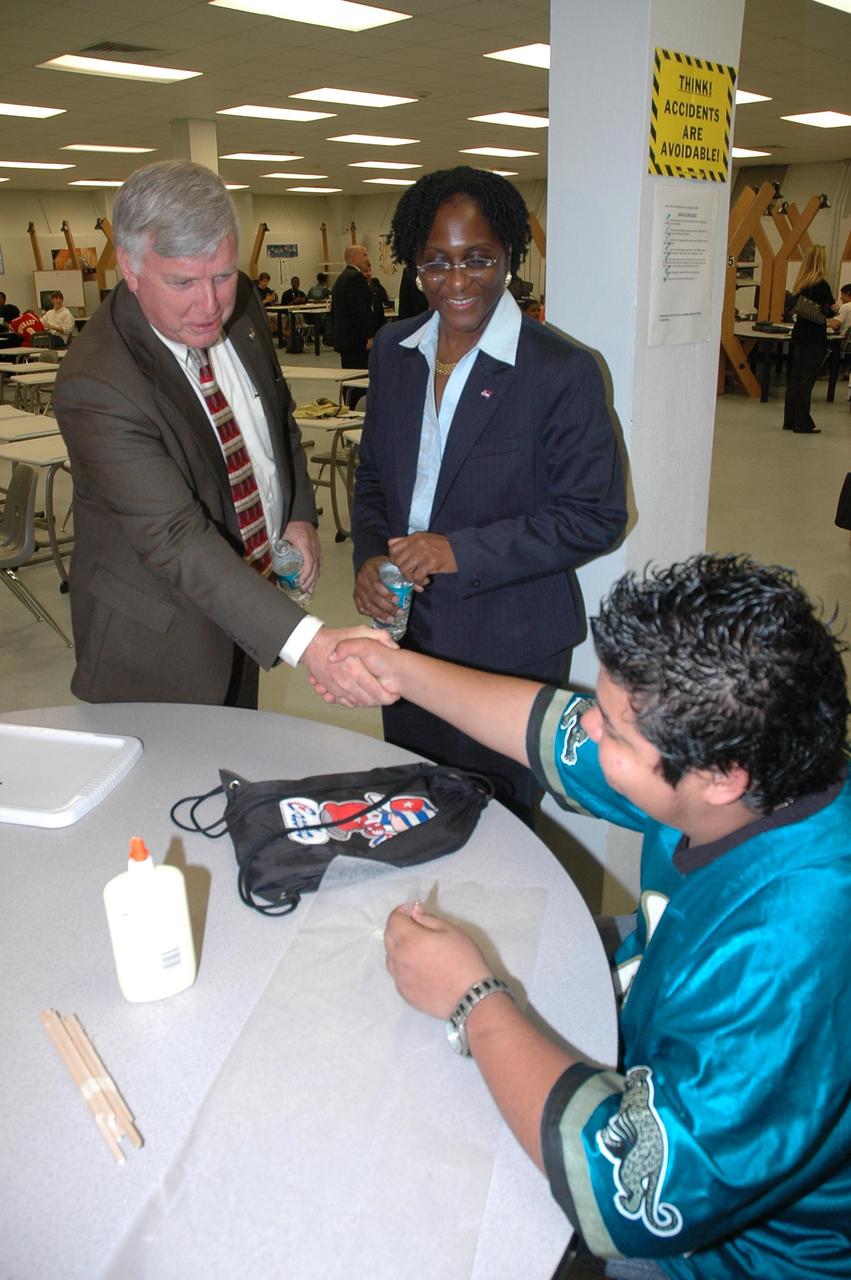
Students from Plantation, Fla., and their mentors prepare their team robot to compete in the NASA/KSC FIRST Southeastern Regional event. FIRST (For Inspiration and Recognition of Science and Technology) events are held nationwide, pitting the student-built robots against each other and the clock on a playing field. Many teams are sponsored by corporations, such as Motorola seen on these students’ shirts, and academic institutions. There are 27 teams throughout the State of Florida who are competing. KSC, which sponsors nine teams, has held the regional event for two years.

Students from Plantation, Fla., and their mentors prepare their team robot to compete in the NASA_KSC FIRST Southeastern Regional event. FIRST (For Inspiration and Recognition of Science and Technology) events are held nationwide, pitting the student-built robots against each other and the clock on a playing field. Many teams are sponsored by corporations, such as Motorola seen on these students’ shirts, and academic institutions. There are 27 teams throughout the State of Florida who are competing. KSC, which sponsors nine teams, has held the regional event for two years.
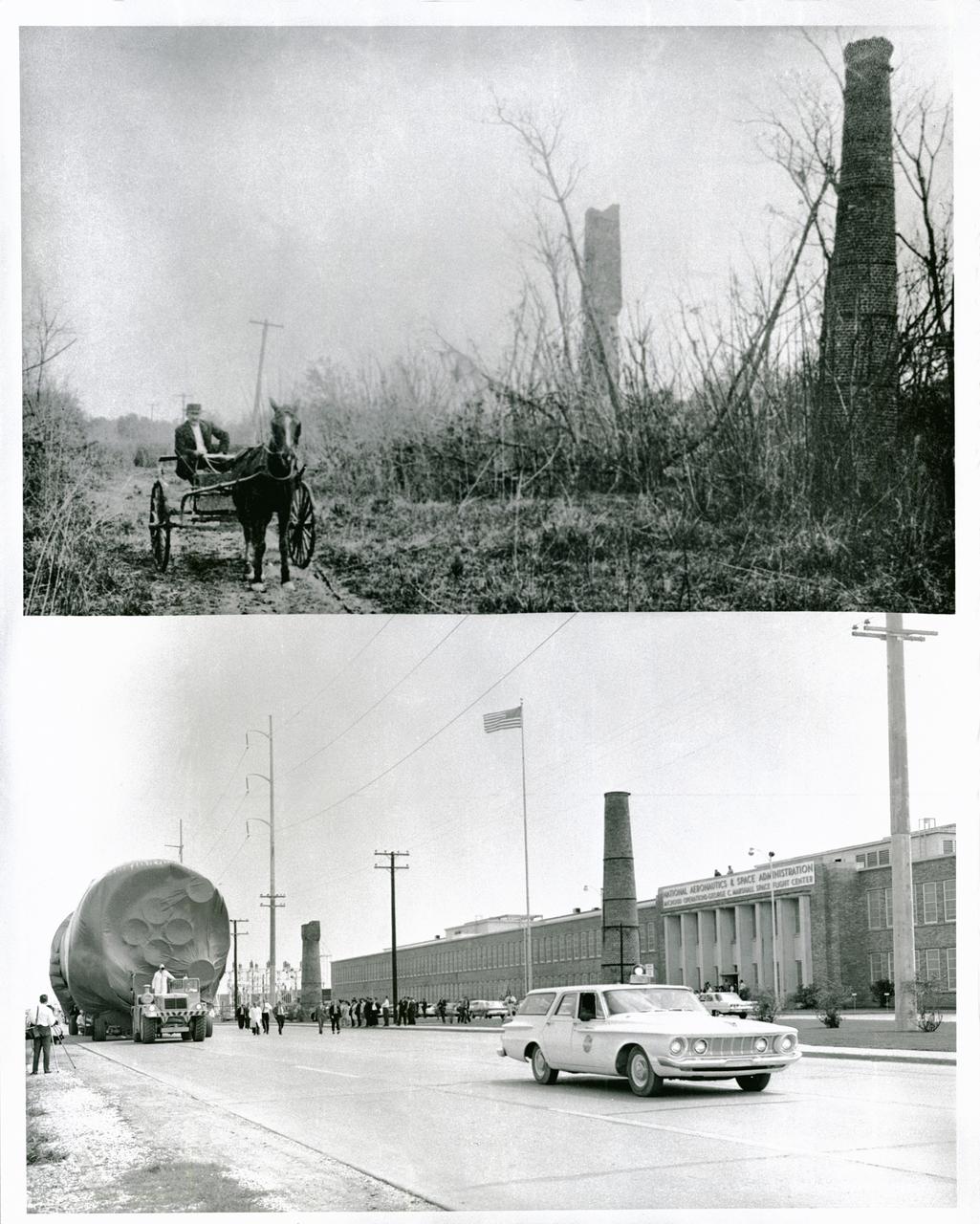
NASA's Michoud Assembly Facility, located in eastern New Orleans, Louisiana, is an 832 acre site that is a government-owned, contractor-operated component of the George C. Marshall Space Flight Center (MSFC). The facility was acquired by NASA in 1961 at the recommendation of Dr. Wernher von Braun and his rocket team in Huntsville Alabama. The cavernous plant served as the assembly facility for the Saturn launch vehicles and most recently the external tank (ET) used for the Space Shuttle Program. The facility features one of the world's biggest manufacturing plants with 43 acres under one roof and a port with deep-water access for the transportation of large space structures. When completed, space hardware is towed on a barge across the Gulf of Mexico, around Florida and up to Kennedy Space Center. The original tract of land was part of a 34,500 acre French Royal land grant to local merchant, Gilbert Antoine de St. Maxent in 1763. Later, the land was acquired by French transplant Antoine Michoud, the son of Napoleon's Administrator of Domains, who moved to the city in 1827. Michoud operated a sugar cane plantation and refinery on the site until his death in 1863. His heirs continued operating the refinery and kept the original St. Maxent estate intact into the 20th century. Two brick smokestacks from the original refinery still stand before the Michoud facility today as seen in the lower half of this photograph taken in the 1960's, while the upper half reflects the area during the time of the sugar cane plantation workers.
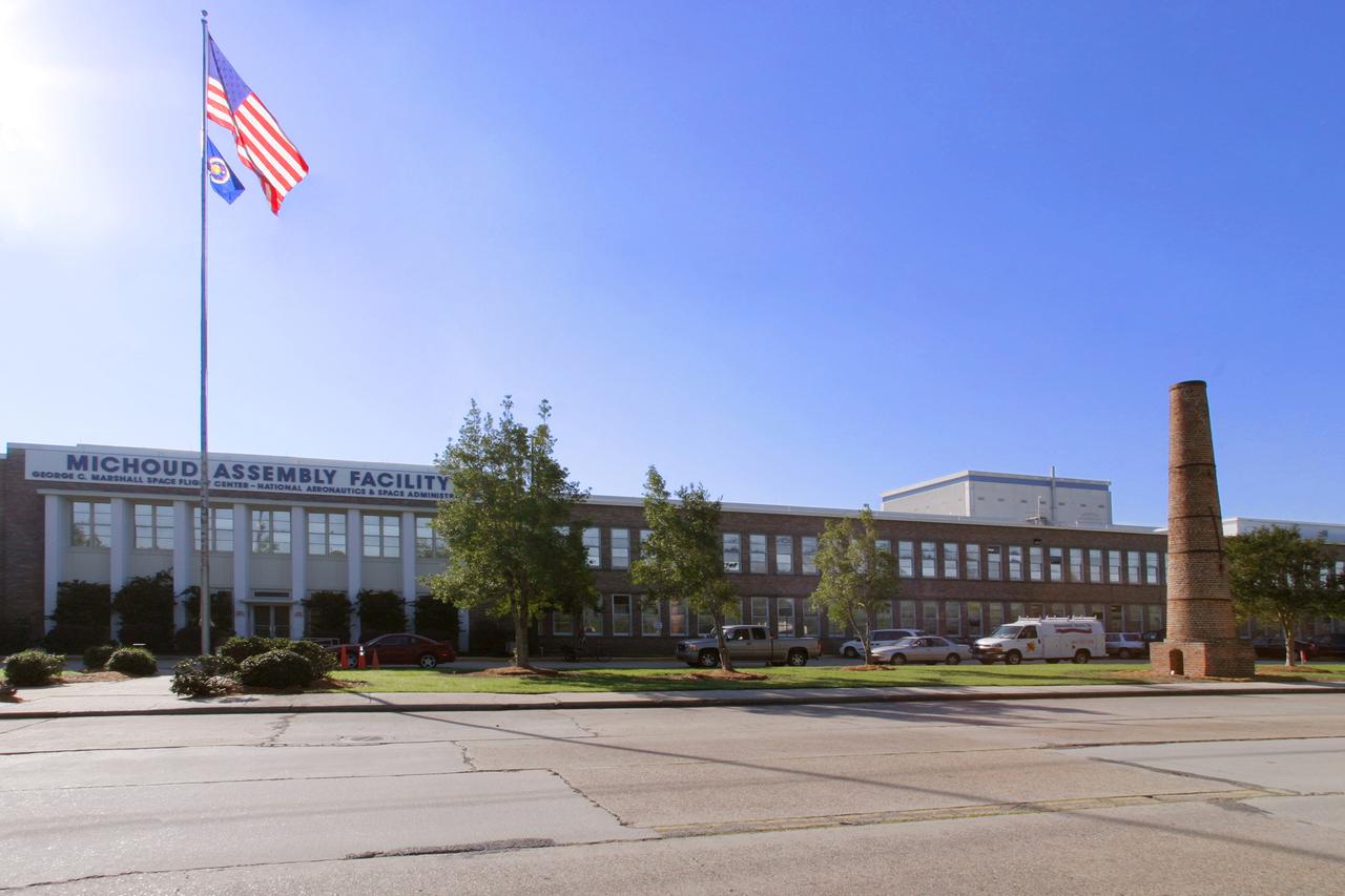
NASA's Michoud Assembly Facility, located in eastern New Orleans, Louisiana, is an 832 acre site that is a government-owned, contractor-operated component of the George C. Marshall Space Flight Center (MSFC). The facility was acquired by NASA in 1961 at the recommendation of Dr. Wernher von Braun and his rocket team in Huntsville Alabama. The cavernous plant served as the assembly facility for the Saturn launch vehicles and most recently the external tank (ET) used for the Space Shuttle Program. The facility features one of the world's biggest manufacturing plants with 43 acres under one roof and a port with deep-water access for the transportation of large space structures. When completed, space hardware is towed on a barge across the Gulf of Mexico, around Florida and up to Kennedy Space Center. The original tract of land was part of a 34,500 acre French Royal land grant to local merchant, Gilbert Antoine de St. Maxent in 1763. Later, the land was acquired by French transplant Antoine Michoud, the son of Napoleon's Administrator of Domains, who moved to the city in 1827. Michoud operated a sugar cane plantation and refinery on the site until his death in 1863. His heirs continued operating the refinery and kept the original St. Maxent estate intact into the 20th century. Visible on the right, is one of two brick smokestacks from the original refinery that still stand before the Michoud facility today.
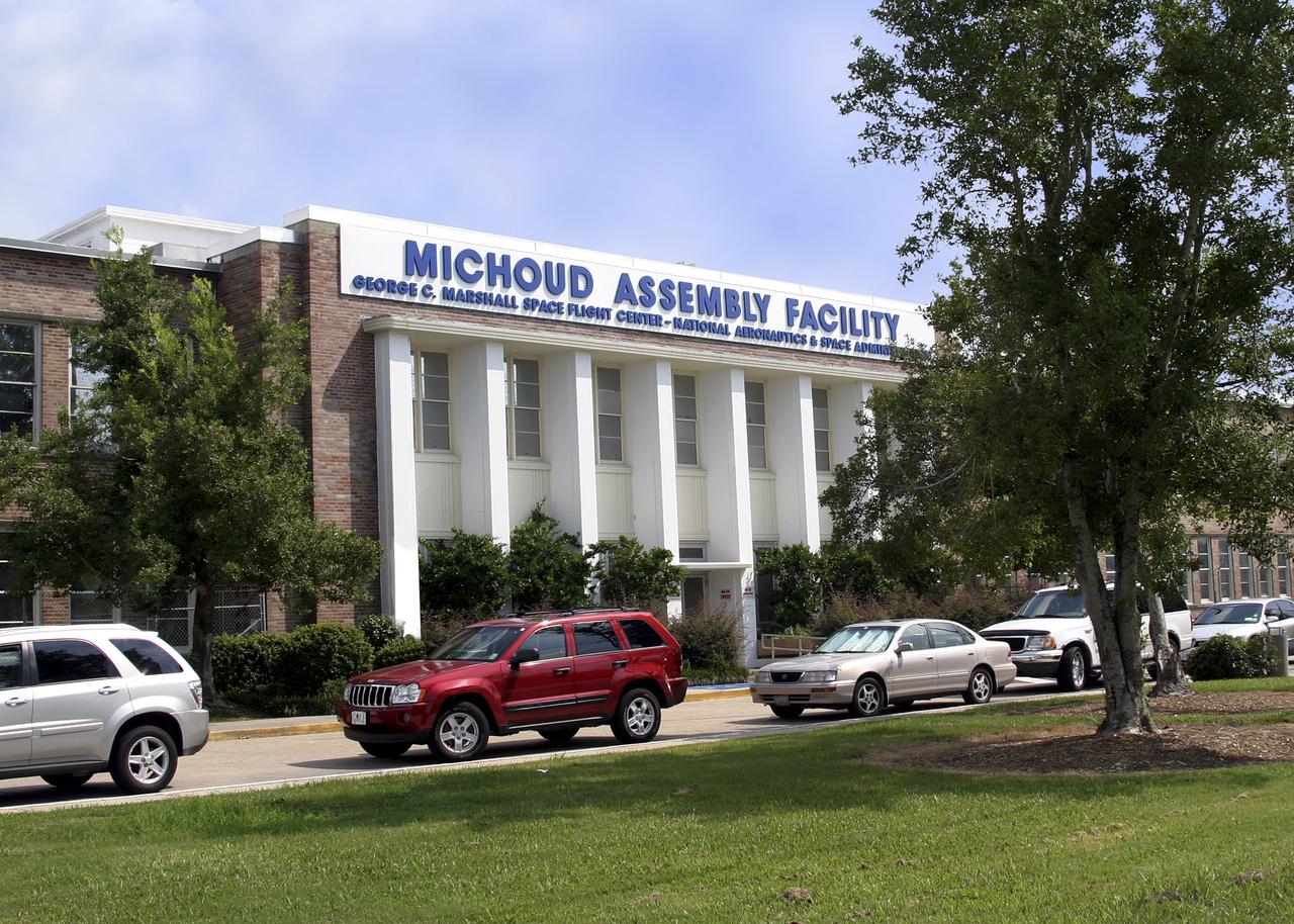
NASA's Michoud Assembly Facility, located in eastern New Orleans, Louisiana, is an 832 acre site that is a government-owned, contractor-operated component of the George C. Marshall Space Flight Center (MSFC). The facility was acquired by NASA in 1961 at the recommendation of Dr. Wernher von Braun and his rocket team in Huntsville Alabama. The cavernous plant served as the assembly facility for the Saturn launch vehicles and most recently the external tank (ET) used for the Space Shuttle Program. The facility features one of the world's biggest manufacturing plants with 43 acres under one roof and a port with deep-water access for the transportation of large space structures. When completed, space hardware is towed on a barge across the Gulf of Mexico, around Florida and up to Kennedy Space Center. The original tract of land was part of a 34,500 acre French Royal land grant to local merchant, Gilbert Antoine de St. Maxent in 1763. Later, the land was acquired by French transplant Antoine Michoud, the son of Napoleon's Administrator of Domains, who moved to the city in 1827. Michoud operated a sugar cane plantation and refinery on the site until his death in 1863. His heirs continued operating the refinery and kept the original St. Maxent estate intact into the 20th century. Two brick smokestacks from the original refinery still stand before the Michoud facility today.
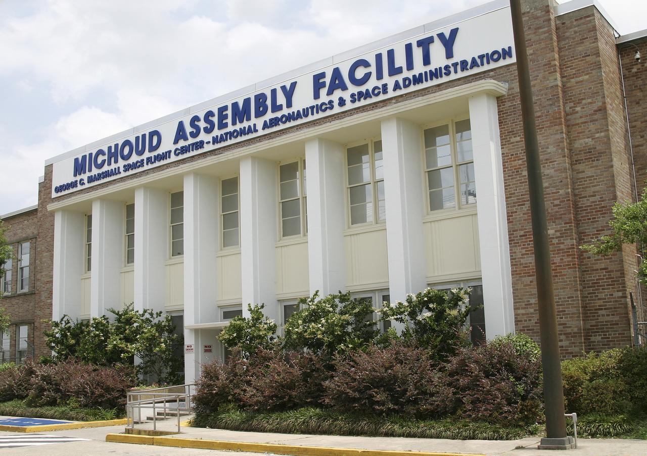
NASA's Michoud Assembly Facility, located in eastern New Orleans, Louisiana, is an 832 acre site that is a government-owned, contractor-operated component of the George C. Marshall Space Flight Center (MSFC). The facility was acquired by NASA in 1961 at the recommendation of Dr. Wernher von Braun and his rocket team in Huntsville Alabama. The cavernous plant served as the assembly facility for the Saturn launch vehicles and most recently the external tank (ET) used for the Space Shuttle Program. The facility features one of the world's biggest manufacturing plants with 43 acres under one roof and a port with deep-water access for the transportation of large space structures. When completed, space hardware is towed on a barge across the Gulf of Mexico, around Florida and up to Kennedy Space Center. The original tract of land was part of a 34,500 acre French Royal land grant to local merchant, Gilbert Antoine de St. Maxent in 1763. Later, the land was acquired by French transplant Antoine Michoud, the son of Napoleon's Administrator of Domains, who moved to the city in 1827. Michoud operated a sugar cane plantation and refinery on the site until his death in 1863. His heirs continued operating the refinery and kept the original St. Maxent estate intact into the 20th century. Two brick smokestacks from the original refinery still stand before the Michoud facility today.
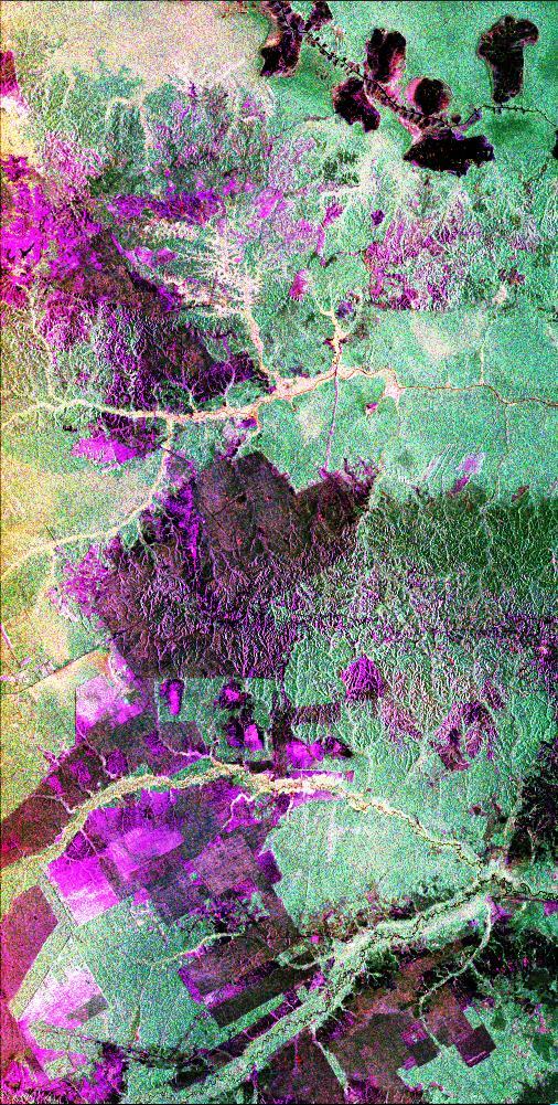
This is a radar image of the central part of the island of Sumatra in Indonesia that shows how the tropical rainforest typical of this country is being impacted by human activity. Native forest appears in green in this image, while prominent pink areas represent places where the native forest has been cleared. The large rectangular areas have been cleared for palm oil plantations. The bright pink zones are areas that have been cleared since 1989, while the dark pink zones are areas that were cleared before 1989. These radar data were processed as part of an effort to assist oil and gas companies working in the area to assess the environmental impact of both their drilling operations and the activities of the local population. Radar images are useful in these areas because heavy cloud cover and the persistent smoke and haze associated with deforestation have prevented usable visible-light imagery from being acquired since 1989. The dark shapes in the upper right (northeast) corner of the image are a chain of lakes in flat coastal marshes. This image was acquired in October 1994 by the Spaceborne Imaging Radar C/X-Band Synthetic Aperture Radar (SIR-C/X-SAR) onboard the space shuttle Endeavour. Environmental changes can be easily documented by comparing this image with visible-light data that were acquired in previous years by the Landsat satellite. The image is centered at 0.9 degrees north latitude and 101.3 degrees east longitude. The area shown is 50 kilometers by 100 kilometers (31 miles by 62 miles). The colors in the image are assigned to different frequencies and polarizations of the radar as follows: red is L-band horizontally transmitted, horizontally received; green is L-band horizontally transmitted, vertically received; blue is L-band vertically transmitted, vertically received. SIR-C/X-SAR, a joint mission of the German, Italian and United States space agencies, is part of NASA's Mission to Planet Earth program. http://photojournal.jpl.nasa.gov/catalog/PIA01797
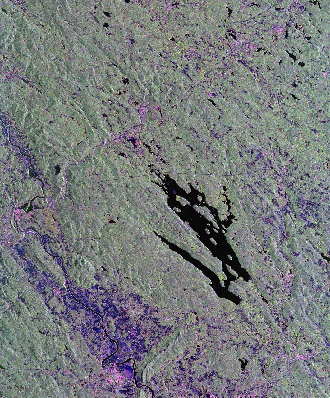
This is a radar image of the area surrounding the Harvard Forest in north-central Massachusetts that has been operated as a ecological research facility by Harvard University since 1907. At the center of the image is the Quabbin Reservoir, and the Connecticut River is at the lower left of the image. The Harvard Forest itself is just above the reservoir. Researchers are comparing the naturally occurring physical disturbances in the forest and the recent and projected chemical disturbances and their effects on the forest ecosystem. Agricultural land appears dark blue/purple, along with low shrub vegetation and some wetlands. Urban development is bright pink; the yellow to green tints are conifer-dominated vegetation with the pitch pine sand plain at the middle left edge of the image appearing very distinctive. The green tint may indicate pure pine plantation stands, and deciduous broadleaf trees appear gray/pink with perhaps wetter sites being pinker. This image was acquired by the Spaceborne Imaging Radar-C/X-Band Synthetic Aperture Radar (SIR-C/X-SAR) aboard the space shuttle Endeavour. SIR-C/X-SAR, a joint mission of the German, Italian and the United States space agencies, is part of NASA's Mission to Planet Earth. The image is centered at 42.50 degrees North latitude and 72.33 degrees West longitude and covers an area of 53 kilometers 63 by kilometers (33 miles by 39 miles). The colors in the image are assigned to different frequencies and polarizations of the radar as follows: red is L-band horizontally transmitted and horizontally received; green is L-band horizontally transmitted and vertically received; and blue is C-band horizontally transmitted and horizontally received. http://photojournal.jpl.nasa.gov/catalog/PIA01788
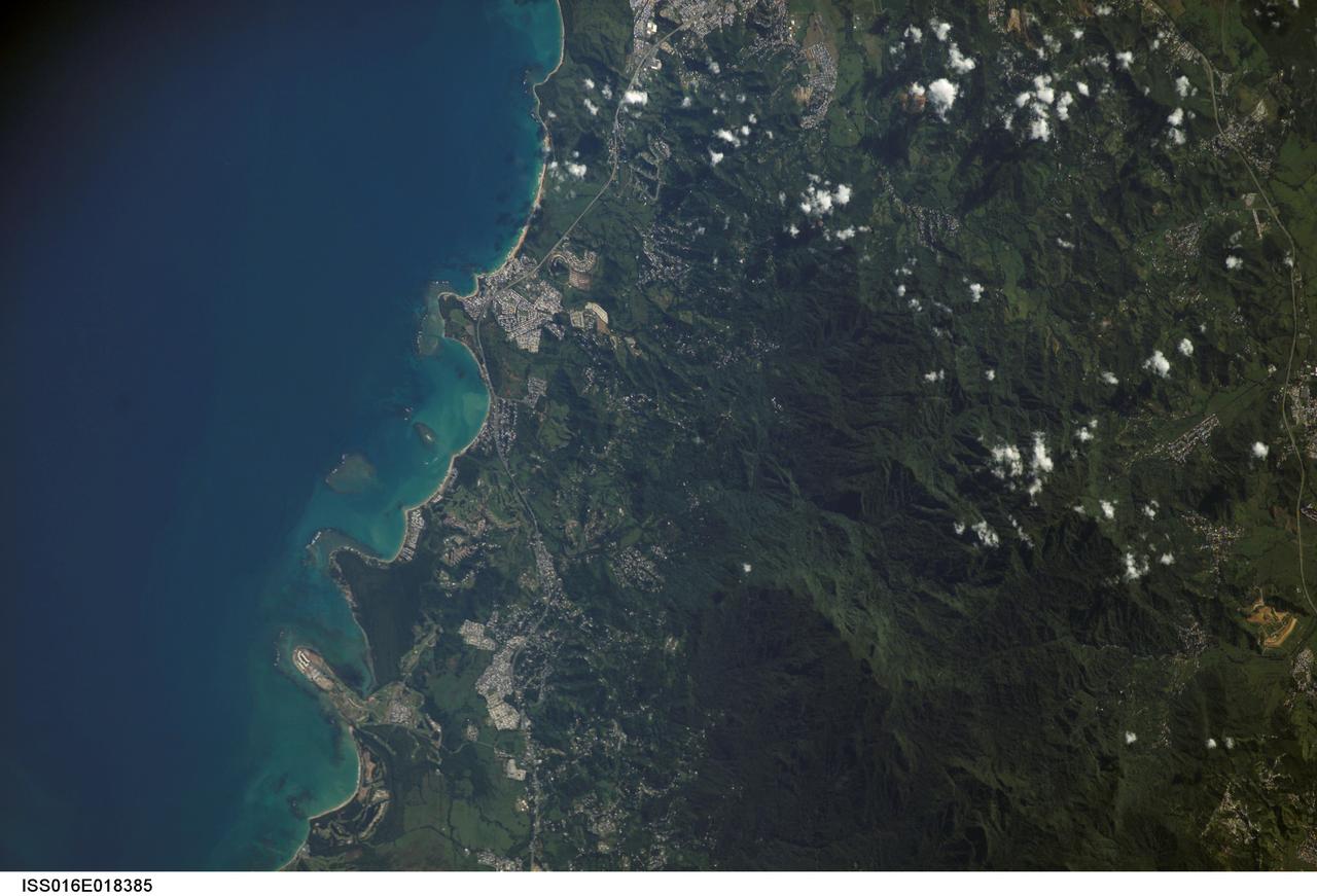
ISS016-E-018385 (23 Dec. 2008) --- Luquillo Mountains, Puerto Rico are featured in this image photographed by an Expedition 16 crewmember on the International Space Station. The Luquillo Mountains are located in the northeastern portion of Puerto Rico and rise to elevations of 1,075 meters. According to scientists, the mountains are comprised mainly of volcanic rock material that was uplifted by tectonism - Puerto Rico is located between the junction of the North American and Caribbean plates - approximately 37--28 million years ago. Prevailing easterly winds bring moisture from the Caribbean Sea that falls as precipitation as they cross the mountains. Higher elevations receive more rainfall than lower elevations, leading to subtropical forest types in the lowlands and montane forest types near the summits. This image, taken during the rainy season, illustrates the rich vegetation cover of the mountains. The rapid change in ecosystems with elevation, land use history, and exposure to frequent natural disturbances (such as hurricanes) makes the Luquillo Mountains as ideal location for ecological study. The Luquillo Experimental Forest Long Term Ecological Research (LTER) site is contained within the Luquillo National Forest, covering much of the mountains to the southwest of the city of Luquillo (center). Historical human land uses in the Forest -- such as logging, agriculture, charcoal production, and coffee plantations - have determined much of the current ecosystem structure. Results of LTER site research indicates that the forest ecosystems recover more rapidly from natural disturbances (like hurricanes) than they do from human disturbance.
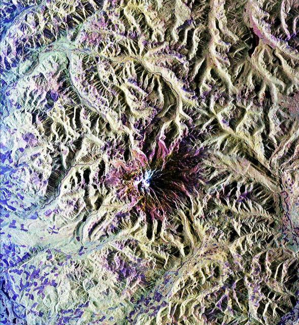
This is a radar image of Mount Rainier in Washington state. The volcano last erupted about 150 years ago and numerous large floods and debris flows have originated on its slopes during the last century. Today the volcano is heavily mantled with glaciers and snowfields. More than 100,000 people live on young volcanic mudflows less than 10,000 years old and, consequently, are within the range of future, devastating mudslides. This image was acquired by the Spaceborne Imaging Radar-C and X-band Synthetic Aperture Radar (SIR-C/X-SAR) aboard the space shuttle Endeavour on its 20th orbit on October 1, 1994. The area shown in the image is approximately 59 kilometers by 60 kilometers (36.5 miles by 37 miles). North is toward the top left of the image, which was composed by assigning red and green colors to the L-band, horizontally transmitted and vertically, and the L-band, horizontally transmitted and vertically received. Blue indicates the C-band, horizontally transmitted and vertically received. In addition to highlighting topographic slopes facing the space shuttle, SIR-C records rugged areas as brighter and smooth areas as darker. The scene was illuminated by the shuttle's radar from the northwest so that northwest-facing slopes are brighter and southeast-facing slopes are dark. Forested regions are pale green in color; clear cuts and bare ground are bluish or purple; ice is dark green and white. The round cone at the center of the image is the 14,435-foot (4,399-meter) active volcano, Mount Rainier. On the lower slopes is a zone of rock ridges and rubble (purple to reddish) above coniferous forests (in yellow/green). The western boundary of Mount Rainier National Park is seen as a transition from protected, old-growth forest to heavily logged private land, a mosaic of recent clear cuts (bright purple/blue) and partially regrown timber plantations (pale blue). The prominent river seen curving away from the mountain at the top of the image (to the northwest) is the White River, and the river leaving the mountain at the bottom right of the image (south) is the Nisqually River, which flows out of the Nisqually glacier on the mountain. The river leaving to the left of the mountain is the Carbon River, leading west and north toward heavily populated regions near Tacoma. The dark patch at the top right of the image is Bumping Lake. Other dark areas seen to the right of ridges throughout the image are radar shadow zones. Radar images can be used to study the volcanic structure and the surrounding regions with linear rock boundaries and faults. In addition, the recovery of forested lands from natural disasters and the success of reforestation programs can also be monitored. Ultimately this data may be used to study the advance and retreat of glaciers and other forces of global change. http://photojournal.jpl.nasa.gov/catalog/PIA01727
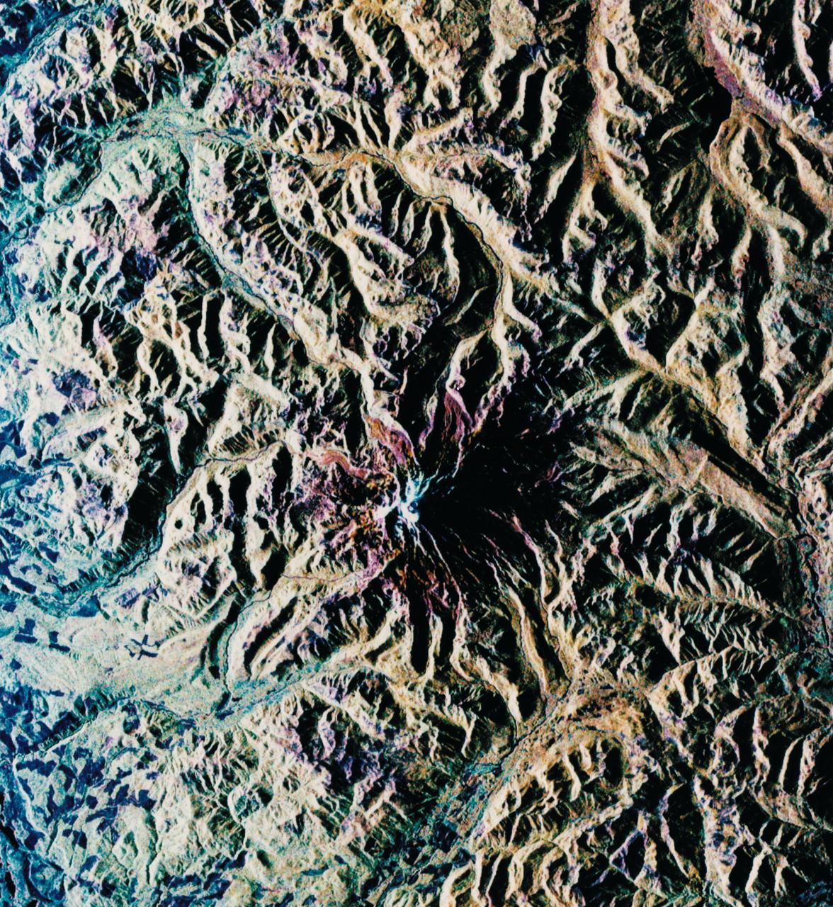
STS068-S-052 (3 October 1994) --- This is a radar image of Mount Rainier in Washington state. The volcano last erupted about 150 years ago and numerous large floods and debris flows have originated on its slopes during the last century. Today the volcano is heavily mantled with glaciers and snow fields. More than 100,000 people live on young volcanic mud flows less than 10,000 years old and, are within the range of future, devastating mud slides. This image was acquired by the Spaceborne Imaging Radar-C/X-Band Synthetic Aperture Radar (SIR-C/X-SAR) aboard the Space Shuttle Endeavour on its 20th orbit on October 1, 1994. The area shown in the image is approximately 59 by 60 kilometers (36.5 by 37 miles). North is toward the top left of the image, which was composed by assigning red and green colors to the L-Band, horizontally transmitted and vertically, and the L-Band, horizontally transmitted and vertically received. Blue indicates the C-Band, horizontally transmitted and vertically received. In addition to highlighting topographic slopes facing the Space Shuttle, SIR-C records rugged areas as brighter and smooth areas as darker. The scene was illuminated by the Shuttle's radar from the northwest so that northwest-facing slopes are brighter and southeast-facing slopes are dark. Forested regions are pale green in color, clear cuts and bare ground are bluish or purple; ice is dark green and white. The round cone at the center of the image is the 14,435 feet (4,399 meters) active volcano, Mount Rainier. On the lower slopes is a zone of rock ridges and rubble (purple to reddish) above coniferous forests (in yellow/green). The western boundary of Mount Rainier National Park is seen as a transition from protected, old-growth forest to heavily logged private land, a mosaic of recent clear cuts (bright purple/blue) and partially re-grown timber plantations (pale blue). The prominent river seen curving away from the mountain at the top of the image (to the northwest) is the White River, and the river leaving the mountain at the bottom right of the image (south) is the Nisqually River, which flows out of the Nisqually glacier on the mountain. The river leaving to the left of the mountain is the Carbon River, leading west and north toward heavily populated regions near Tacoma. The dark patch at the top right of the image is Bumping Lake. Other dark areas seen to the right of ridges throughout the image are radar shadow zones. Radar images can be used to study the volcanic structure and the surrounding regions with linear rock boundaries and faults. In addition, the recovery of forested lands from natural disasters and the success of re-forestation programs can also be monitored. Ultimately this data may be used to study the advance and retreat of glaciers and other forces of global change. Spaceborne Imaging Radar-C/X-Band Synthetic Aperture Radar (SIR-C/X-SAR) is part of NASA's Mission to Planet Earth. (P-44703)
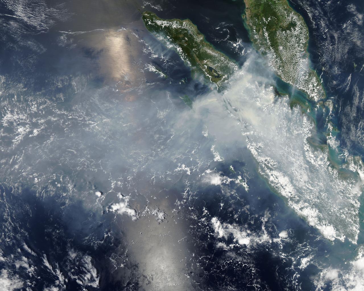
Fires burning in Sumatra continued to pour smoke over the region in mid-March, 2014, bringing air quality to dangerous levels. The Moderate Resolution Imaging Spectroradiometer (MODIS) aboard NASA’s Aqua satellite captured this true-color image of the smoke and haze across the region on March 12. According to the Jakarta Post, on March 12 the Sumatra Environmental Laboratory reported that 10 of 12 spots in Riau had an air quality of index above 300 on the Pollutant Standards Index (PSI), which is considered hazardous. Hazardous air quality had been recorded in some of the locations for 11 consecutive days. The province of Riau is located in the central eastern coast of Sumatra and, in this image, is hidden under thick bands of light gray smoke. Intense fires, reported as deliberately set to clear land, were burning in the Giam Siak Kecil-Bukit Batu biosphere reserve. This reserve contains over 700,000 hectares of sensitive peat forest that sustains a wide range of plant and animal species, including the Sumatra tiger, elephant, tapir and sun bear. With visibility as low as 500 m (1640 ft), 58 flights were cancelled in Pekanbaru, the capital of Riau province, on March 11. Schools were closed across the region, with 43,000 students affected in Payakumbuh, West Sumatra. On March 14, Selangor, Malaysia closed 203 schools, affecting 211,700 pupils, until the air quality improved. On that same day, according to Riau Health Agency, more than 55,000 residents in the province were suffering from haze-related illnesses, including acute respiratory infections, pneumonia and skin and eye irritation. Poor air quality not only affected transportation, human health and the ecosystem, but has had significant economic impacts. On March 17, Reuters reported that the poor air quality had forced Chevron, the country’s biggest oil producer, to close hundreds of its wells. As a result, Indonesia’s crude oil output dropped to 790,000 barrels per day (bpd) – significantly lower than the 870,000 bpd target. Although slash-and-burn techniques, which use fire to clear land, is illegal in Indonesia, the practice is still widespread, with approximately 99% of fires in Sumatra considered to be intentionally set. This year’s early agricultural fires began in February in Riau Province, home to palm-oil and pulpwood plantations. The emergency has prompted strong government response, including a shoot-on-sight order for any suspects involved in land burning activities that resisted arrest. According to the Jakarta Post, police have named as many as 60 suspected-fire starters in Riau. Credit: NASA/GSFC/Jeff Schmaltz/MODIS Land Rapid Response Team <b><a href="http://www.nasa.gov/audience/formedia/features/MP_Photo_Guidelines.html" rel="nofollow">NASA image use policy.</a></b> <b><a href="http://www.nasa.gov/centers/goddard/home/index.html" rel="nofollow">NASA Goddard Space Flight Center</a></b> enables NASA’s mission through four scientific endeavors: Earth Science, Heliophysics, Solar System Exploration, and Astrophysics. Goddard plays a leading role in NASA’s accomplishments by contributing compelling scientific knowledge to advance the Agency’s mission. <b>Follow us on <a href="http://twitter.com/NASAGoddardPix" rel="nofollow">Twitter</a></b> <b>Like us on <a href="http://www.facebook.com/pages/Greenbelt-MD/NASA-Goddard/395013845897?ref=tsd" rel="nofollow">Facebook</a></b> <b>Find us on <a href="http://instagram.com/nasagoddard?vm=grid" rel="nofollow">Instagram</a></b>