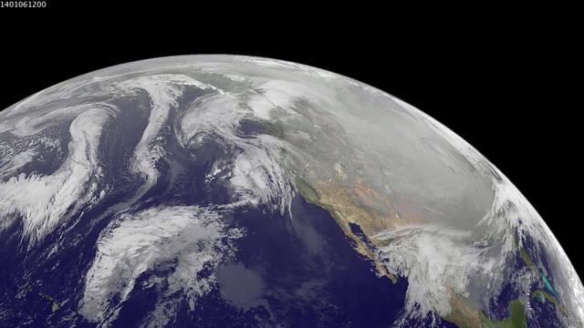
1-9 January 2014. The full-disk images every 3 hours from GOES-WEST capture the sweep of a polar vortex that emerged from the arctic at the beginning of the new year, pushing a blizzard into the northeastern USA on January 3, followed by extensive bitter cold (-20 F, windchill -50 F) around the Great Lakes, and single digit temperatures as far south as Atlanta, Georgia. This western viewpoint displays the persistent flow of arctic air from northern Alaska and Yukon into North America. <b><a href="http://goes.gsfc.nasa.gov/" rel="nofollow">Credit: NOAA/NASA GOES Project</a></b> <b><a href="http://www.nasa.gov/audience/formedia/features/MP_Photo_Guidelines.html" rel="nofollow">NASA image use policy.</a></b> <b><a href="http://www.nasa.gov/centers/goddard/home/index.html" rel="nofollow">NASA Goddard Space Flight Center</a></b> enables NASA’s mission through four scientific endeavors: Earth Science, Heliophysics, Solar System Exploration, and Astrophysics. Goddard plays a leading role in NASA’s accomplishments by contributing compelling scientific knowledge to advance the Agency’s mission. <b>Follow us on <a href="http://twitter.com/NASA_GoddardPix" rel="nofollow">Twitter</a></b> <b>Like us on <a href="http://www.facebook.com/pages/Greenbelt-MD/NASA-Goddard/395013845897?ref=tsd" rel="nofollow">Facebook</a></b> <b>Find us on <a href="http://instagram.com/nasagoddard?vm=grid" rel="nofollow">Instagram</a></b>
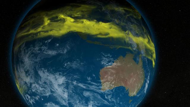
Caption: This is a conceptual animation showing ozone-depleting chemicals moving from the equator to the poles. The chemicals become trapped by the winds of the polar vortex, a ring of fast moving air that circles the South Pole. Watch full video: <a href="https://youtu.be/7n2km69jZu8" rel="nofollow">youtu.be/7n2km69jZu8</a> -- The next three decades will see an end of the era of big ozone holes. In a new study, scientists from NASA Goddard Space Flight Center say that the ozone hole will be consistently smaller than 12 million square miles by the year 2040. Ozone-depleting chemicals in the atmosphere cause an ozone hole to form over Antarctica during the winter months in the Southern Hemisphere. Since the Montreal Protocol agreement in 1987, emissions have been regulated and chemical levels have been declining. However, the ozone hole has still remained bigger than 12 million square miles since the early 1990s, with exact sizes varying from year to year. The size of the ozone hole varies due to both temperature and levels of ozone-depleting chemicals in the atmosphere. In order to get a more accurate picture of the future size of the ozone hole, scientists used NASA’s AURA satellite to determine how much the levels of these chemicals in the atmosphere varied each year. With this new knowledge, scientists can confidently say that the ozone hole will be consistently smaller than 12 million square miles by the year 2040. Scientists will continue to use satellites to monitor the recovery of the ozone hole and they hope to see its full recovery by the end of the century. Research: Inorganic chlorine variability in the Antarctic vortex and implications for ozone recovery. Journal: Geophysical Research: Atmospheres, December 18, 2014. Link to paper: <a href="http://onlinelibrary.wiley.com/doi/10.1002/2014JD022295/abstract" rel="nofollow">onlinelibrary.wiley.com/doi/10.1002/2014JD022295/abstract</a>.
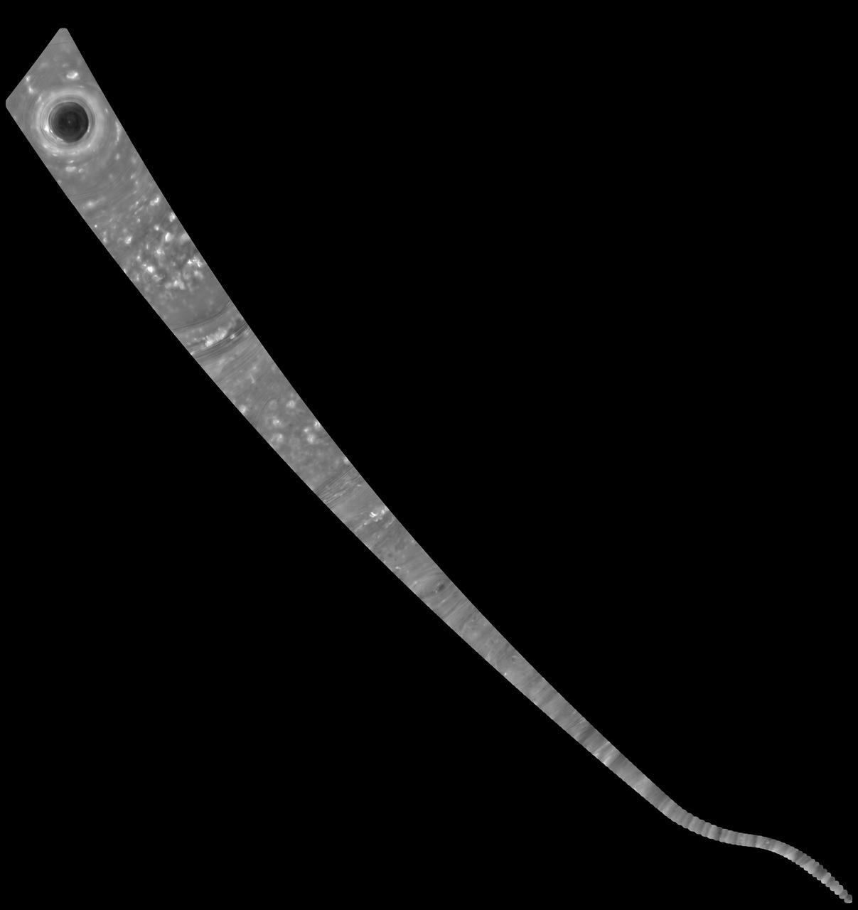
This mosaic of images combines views captured by NASA's Cassini spacecraft as it made the first dive of the mission's Grand Finale on April 26, 2017. It shows a vast swath of Saturn's atmosphere, from the north polar vortex to the boundary of the hexagon-shaped jet stream, to details in bands and swirls at middle latitudes and beyond. The mosaic is a composite of 137 images captured as Cassini made its first dive toward the gap between Saturn and its rings. It is an update to a previously released image product. In the earlier version, the images were presented as individual movie frames, whereas here, they have been combined into a single, continuous mosaic. The mosaic is presented as a still image as well as a video that pans across its length. Imaging scientists referred to this long, narrow mosaic as a "noodle" in planning the image sequence. The first frame of the mosaic is centered on Saturn's north pole, and the last frame is centered on a region at 18 degrees north latitude. During the dive, the spacecraft's altitude above the clouds changed from 45,000 to 3,200 miles (72,400 to 8374 kilometers), while the image scale changed from 5.4 miles (8.7 kilometers) per pixel to 0.6 mile (1 kilometer) per pixel. The bottom of the mosaic (near the end of the movie) has a curved shape. This is where the spacecraft rotated to point its high-gain antenna in the direction of motion as a protective measure before crossing Saturn's ring plane. The images in this sequence were captured in visible light using the Cassini spacecraft wide-angle camera. The original versions of these images, as sent by the spacecraft, have a size of 512 by 512 pixels. The small image size was chosen in order to allow the camera to take images quickly as Cassini sped over Saturn. These images of the planet's curved surface were projected onto a flat plane before being combined into a mosaic. Each image was mapped in stereographic projection centered at 55 degree north latitude. A movie is available at https://photojournal.jpl.nasa.gov/catalog/PIA21617