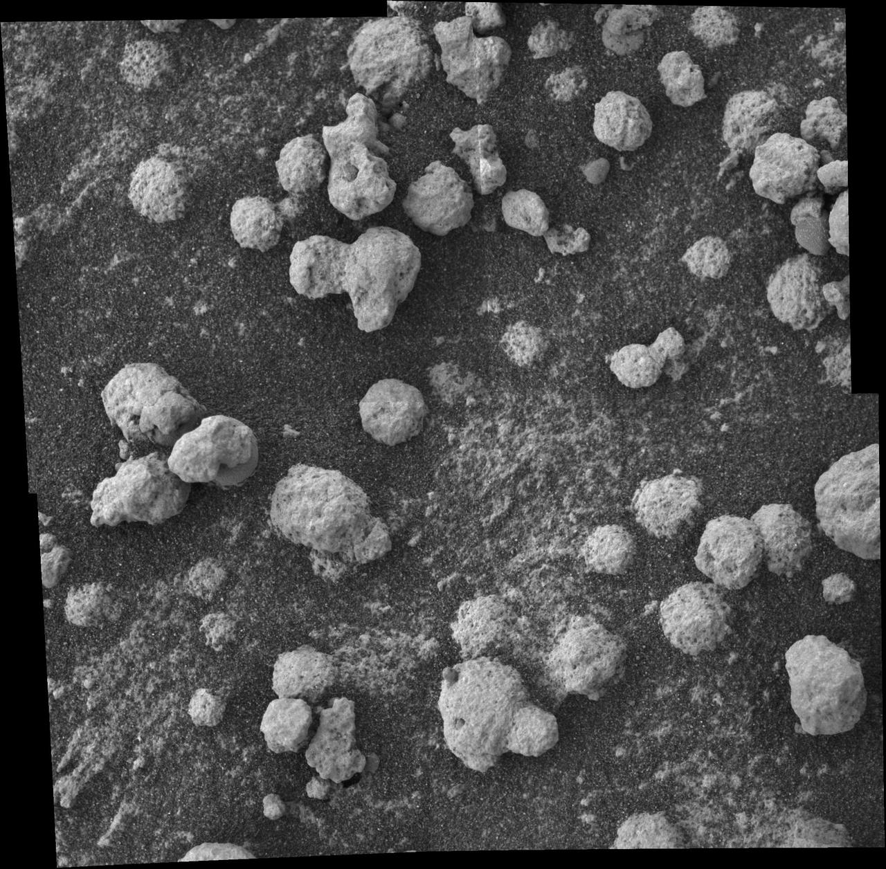
Blueberries and Popcorn
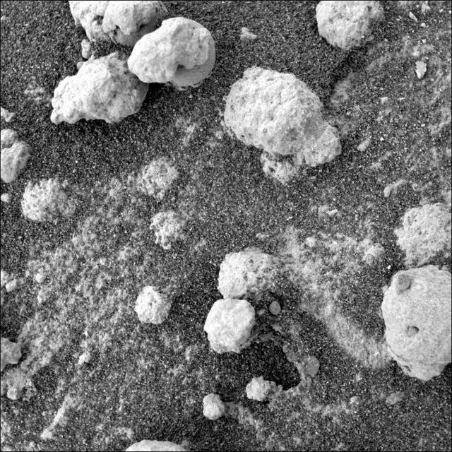
This view from the microscopic imager on NASA Mars Exploration Rover Opportunity shows a type of light-colored, rough-textured spherules scientists call popcorn in contrast to the darker, smoother spherules called blueberries.

Popcorn awaits guests prior to the screening of the NASA produced documentary “The Color of Space” at Howard University’s Cramton Auditorium in Washington, Saturday, June 18, 2022. Premiering on Juneteenth, the federal holiday commemorating the end of slavery in the United States, “The Color of Space” is an inspirational documentary that tells the stories of NASA’s Black astronauts determined to reach the stars. Photo Credit: (NASA/Bill Ingalls)

“We did science fair projects in eighth grade. So my dad and I designed an experiment to look at what cooking oil is best for cooking popcorn. Now you go to science fairs and you see this experiment everywhere. But in 1989, it was like, ‘wow, a kid who knows the scientific method!’ “I made a lot of popcorn. My poor brothers had to eat it all. I measured volume popped and how many kernels were left unpopped. But I also measured the taste factor. For example, cooking popcorn in peanut oil actually has good yield but it doesn’t taste good. “In high school, I had this chemistry teacher named Carol Palmer. I’ll never forget her. The science fairs were really important to her. She had partnerships with laboratories in town, and through this program, I got to go to a stainless steel foundry. “Do you know what paper machines are like? Picture giant rolls, like the size of an 18-wheeler truckbed. This place made those things. This was the early 90s, so we were just starting to recycle paper. But the machines had begun falling apart because of all the corrosive chemicals added to the mix to remove ink. I was simulating that process in the laboratory through different experiments. And I won two years in a row at the state-level science fair: I won first prize in electrochemistry and I won first prize in chemistry. “It was all because of this teacher. And to be honest, I wouldn’t have known that materials science was a thing or that I should study it if I hadn’t had that opportunity. It really put me on course.” Kathleen Boggs, Systems and Technology Demonstration Manager in the International Space Station Division of the Human Exploration and Operations Mission Directorate, Thursday, March 5, 2020, at NASA Headquarters in Washington, DC. Photo Credit: (NASA/Joel Kowsky)
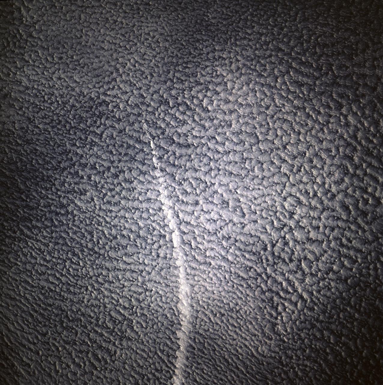
STS071-745-006 (27 June-7 July 1995) --- This view shows a ship track, probably in the northern Pacific Ocean, where a ship has caused clouds to form more thickly directly above the path of this ship. This track is therefore visible even though the ship itself is not. Ship tracks are thought to be caused by particles thrown up into the air by the ship, from smokestack emissions and from water particles generated by the ship moving through the sea. Under favorable weather conditions, water condenses around these particles to form clouds, in this case thicker "popcorn" clouds than already exists in the area. Ongoing studies are attempting to understand this phenomenon better.
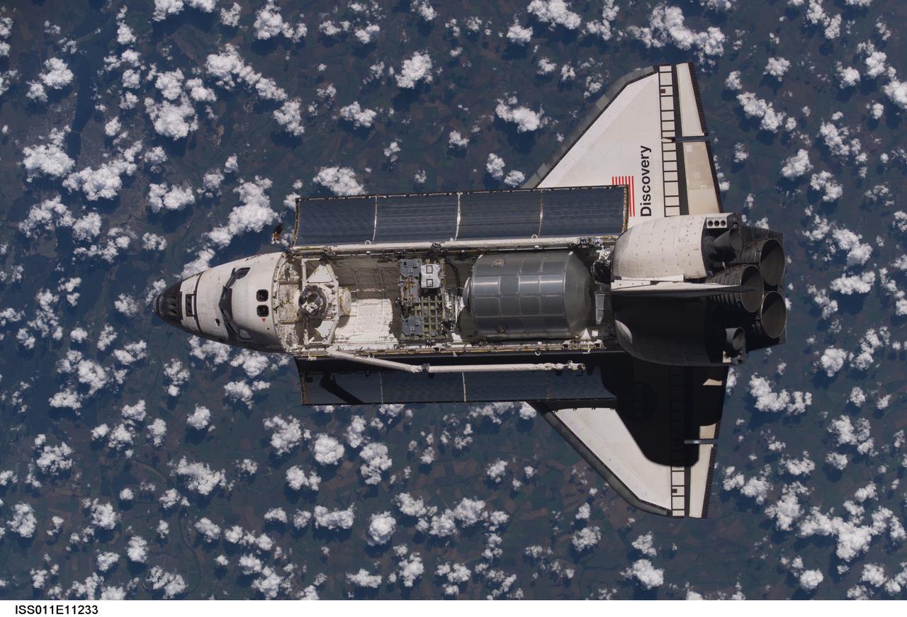
Launched on July 26, 2005 from the Kennedy Space Center in Florida, STS-114 was classified as Logistics Flight 1. Among the Station-related activities of the mission were the delivery of new supplies and the replacement of one of the orbital outpost's Control Moment Gyroscopes (CMGs). STS-114 also carried the Raffaello Multi-Purpose Logistics Module (MPLM) and the External Stowage Platform-2. Back dropped by popcorn-like clouds, the MPLM can be seen in the cargo bay as Discovery undergoes rendezvous and docking operations. Cosmonaut Sergei K. Kriklev, Expedition 11 Commander, and John L. Phillips, NASA Space Station officer and flight engineer photographed the spacecraft from the International Space Station (ISS).
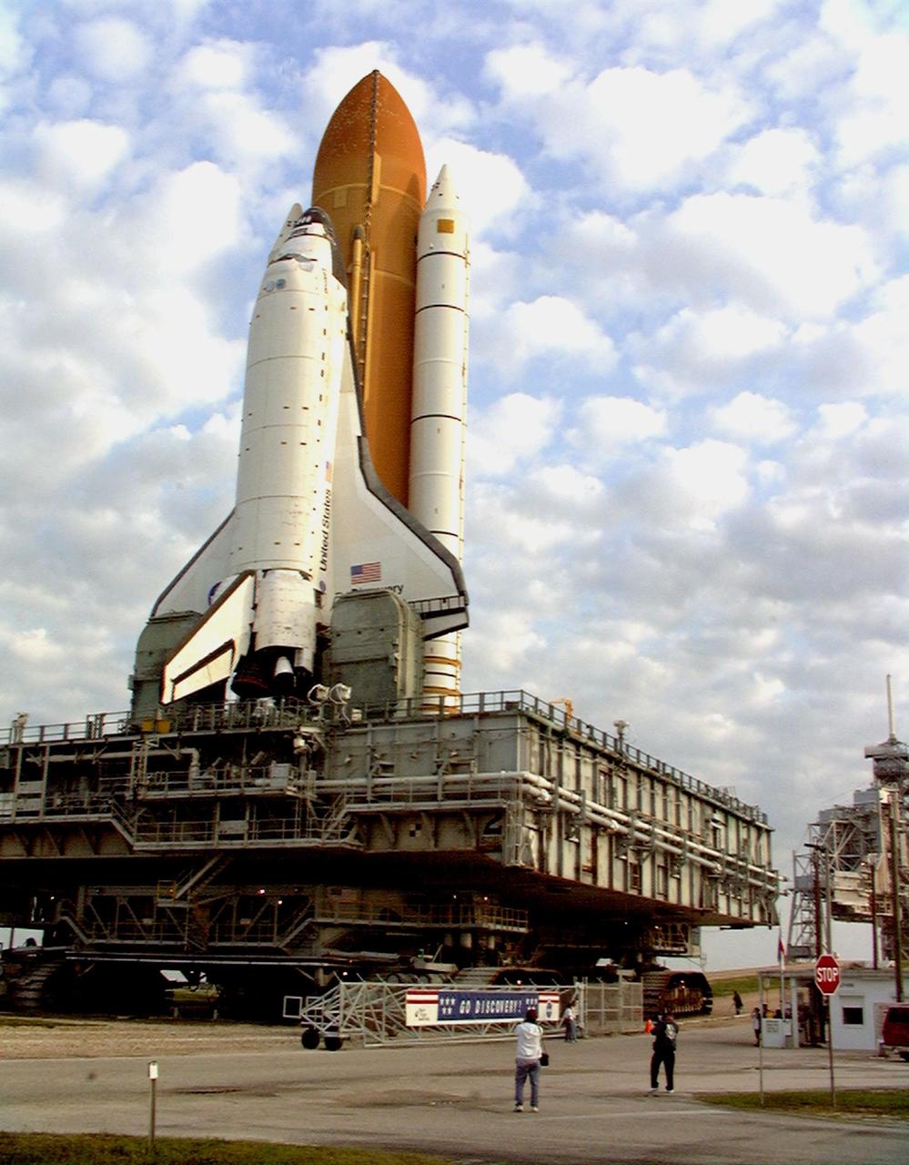
Against a popcorn-clouded blue sky, Space Shuttle Discovery, atop the mobile launcher platform and crawler transporter, ends its five-hour trek from the Vehicle Assembly Building as it crosses through the gate at Launch Pad 39B. Earlier in the week, the Shuttle was rolled back to the VAB from the pad to repair hail damage on the external tank's foam insulation. The 4.2-mile trek takes about five hours at the 1-mph speed of the crawler. Mission STS-96, the 94th launch in the Space Shuttle Program, is scheduled for liftoff May 27 at 6:48 a.m. EDT STS-96 is a logistics and resupply mission for the International Space Station, carrying such payloads as a Russian crane, the Strela; a U.S.-built crane; the Spacehab Oceaneering Space System Box (SHOSS), a logistics items carrier; and STARSHINE, a student-shared experiment
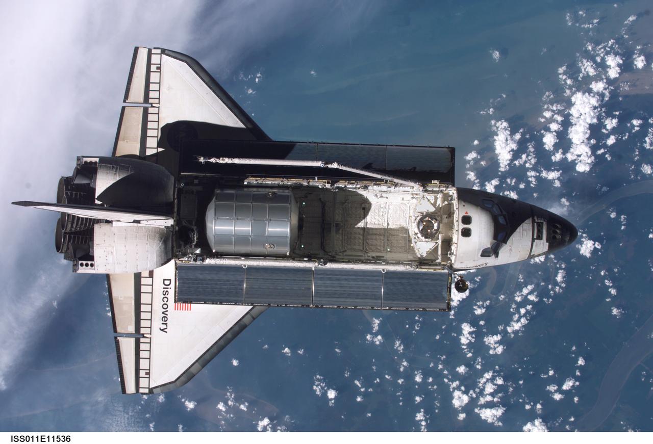
Launched on July 26 2005 from the Kennedy Space Center in Florida, STS-114 was classified as Logistics Flight 1. Among the Station-related activities of the mission were the delivery of new supplies and the replacement of one of the orbital outpost's Control Moment Gyroscopes (CMGs). STS-114 also carried the Raffaello Multi-Purpose Logistics Module (MPLM) and the External Stowage Platform-2. Back dropped by popcorn-like clouds, the MPLM can be seen in the cargo bay as Discovery undergoes rendezvous and docking operations. Cosmonaut Sergei K. Kriklev, Expedition 11 Commander, and John L. Phillips, NASA Space Station officer and flight engineer photographed the spacecraft from the International Space Station (ISS).

ISS040-E-089959 (8 Aug. 2014) --- King Sound on the northwest coast of Australia is featured in this image photographed by an Expedition 40 crew member on the International Space Station. The Fitzroy River, one of Australia's largest, empties into the Sound, a large gulf in Western Australia (approximately 120 kilometers long). King Sound has the highest tides in Australia, in the range of 11-12 meters, the second highest in the world after the Bay of Fundy on the east coast of North America. The strong brown smudge at the head of the Sound contrasts with the clearer blue water along the rest of the coast. This is mud stirred up by the tides and also supplied by the Fitzroy River. The bright reflection point of the sun obscures the blue water of the Indian Ocean (top left). Just to the west of the Sound, thick plumes of wildfire smoke, driven by northeast winds, obscure the coastline. A wide field of “popcorn cumulus” clouds (right) is a common effect of daily heating of the ground surface.
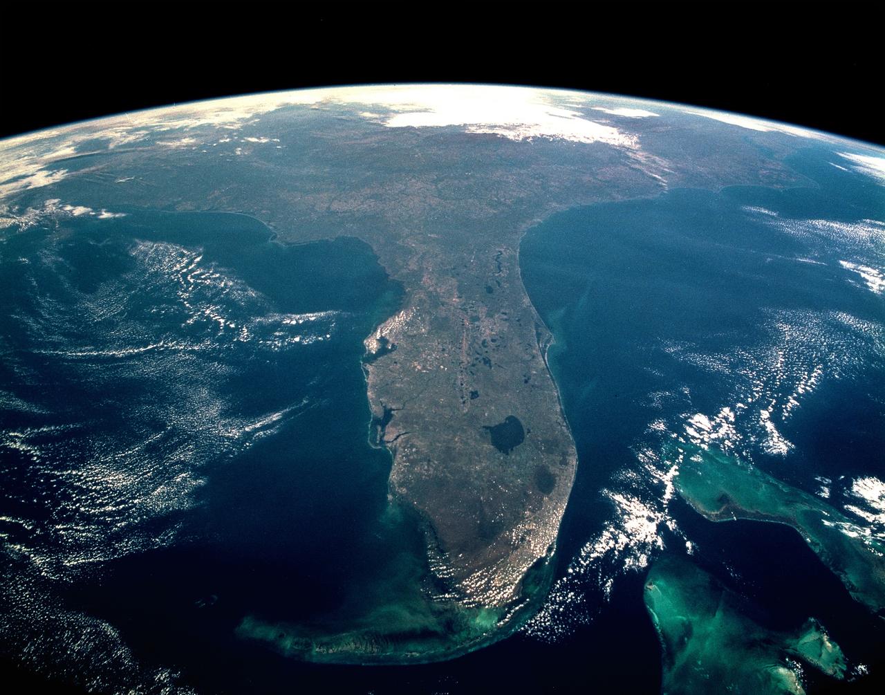
CAPE CANAVERAL, Fla. -- Taken during the STS-95 mission from a point over Cuba, this photo shows an oblique, foreshortened view of the Florida Peninsula, with the light blue, shallow seafloor of both the Florida Keys (curving across the bottom of the view) and the Bahama banks (right). "Popcorn" cumulus cloud covers Miami and the Southern Everglades, although the built-up area from Ft. Lauderdale to West Palm Beach can be discerned. Lake Okeechobee is the prominent waterbody in Florida. Cape Canaveral is shown well, half way up the peninsula. Orlando appears as the lighter patch West (left) of Cape Canaveral, near the middle of the peninsula. Cape Hatteras appears top right, with the North part of Chesapeake Bay also visible. This is a visibility of 16 degrees of latitude (23 degrees N over Cuba to 39 degrees at Baltimore), showing unusual atmospheric clarity.

ISS013-E-74843 (2 Sept. 2006) --- Rio Negro in Amazonia, Brazil is featured in this image photographed by an Expedition 13 crewmember onboard the International Space Station. The wide, multi-island zone in the Rio Negro (Black River) shown in this image is one of two, long "archipelagoes" upstream of the city of Manaus (not shown) in central Amazonia. Ninety kilometers of the total 120 kilometers length of this archipelago appear in this view. On the day the photo was taken, air temperatures over the cooler river water of the archipelago were just low enough to prevent cloud formation. Over the neighboring rainforest, temperatures were warm enough to produce small convection-related clouds, known to pilots as "popcorn" cumulus. Several zones of deforestation, represented by lighter green zones along the river banks, are also visible. Two different types of river appear in this image. Flowing east-southeast (left to right) is the multi-island, Rio Negro, 20 kilometers wide near the right of the view. Two other "black" rivers, Rio Caures and Rio Jufari, join Rio Negro downstream. The second river type is the Rio Branco (White River; right) which is the largest tributary of the Rio Negro. The difference in water color is controlled by the source regions: black-water rivers derive entirely from soils of lowland forests. Water in these rivers has the color of weak tea, which appears black in images from space. By contrast, white-water rivers like the Branco carry a load of sand and mud particles, mudding the waters. The reason for the tan color is that white-water rivers rise in mountainous country where headwater streams erode exposed rock. The Amazon itself rises in the Andes Mts., where very high erosion occurs, and it is thus the most famous white river in Amazonia. This image was taken in September, near low-water stage. Pictures taken at other times show the channels much wider during high-water season (May--July) when water levels rise several meters. It was discovered recently, from high resolution GPS measurements at Manaus, that the land surface actually rises vertically a small amount in compensation when this vast mass of water drains away each season. Although small, the vertical displacement--50-70 mm--was unexpectedly large according to the scientists who performed the study.
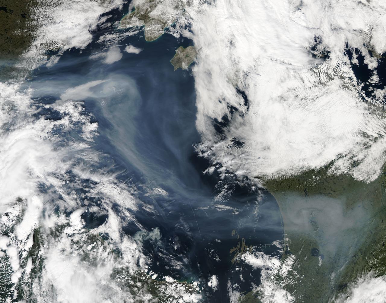
A vigorous summer fire season continued through July, 2013 as many large wildfires continued to burn in the forests of northern Canada. The high fire activity not only laid waste to thousands of hectares of boreal forest, but sent thick smoke billowing high into the atmosphere, where it was carried far across the Atlantic Ocean. On July 30, the Moderate Resolution Imaging Spectroradiometer (MODIS) aboard NASA’s Aqua satellite captured this true-color image of a river of smoke spreading south across the Hudson Bay. The blue background is formed by the waters of Hudson Bay. In the southeast the green, forest-covered land of Quebec province peeks from under a large cloud bank. Another large bank of white cloud covers the water in the southwest, and a smaller cloud bank covers the territory of Nunavut in the northwest. A bit of Baffin Island can be seen near the top center of the image. Looking closely at the image, it appears that the gray smoke mixes with whiter cloud in the south, suggesting they may be at the same level in the atmosphere. In the northeast corner of the image, a ribbon of smoke appears to blow over a bank of popcorn clouds as well as over a few lower-lying clouds, causing some of the clouds to appear gray beneath the smoky veil. Where cloud meets smoke in the northeast, however, the line of the cloud bank remains sharp, while the smoke appears to continue traveling under the edge. Although these interpretations are somewhat subjective in this true-color image, the false-color image of the same scene (not shown here) lends strength to the interpretation. Data from other NASA instruments, designed to measure cloud height and characteristics, agree that clouds vary in height, and that smoke mingles with cloud in the south. Credit: NASA/GSFC/Jeff Schmaltz/MODIS Land Rapid Response Team <b><a href="http://www.nasa.gov/audience/formedia/features/MP_Photo_Guidelines.html" rel="nofollow">NASA image use policy.</a></b> <b><a href="http://www.nasa.gov/centers/goddard/home/index.html" rel="nofollow">NASA Goddard Space Flight Center</a></b> enables NASA’s mission through four scientific endeavors: Earth Science, Heliophysics, Solar System Exploration, and Astrophysics. Goddard plays a leading role in NASA’s accomplishments by contributing compelling scientific knowledge to advance the Agency’s mission. <b>Follow us on <a href="http://twitter.com/NASA_GoddardPix" rel="nofollow">Twitter</a></b> <b>Like us on <a href="http://www.facebook.com/pages/Greenbelt-MD/NASA-Goddard/395013845897?ref=tsd" rel="nofollow">Facebook</a></b> <b>Find us on <a href="http://instagram.com/nasagoddard?vm=grid" rel="nofollow">Instagram</a></b>