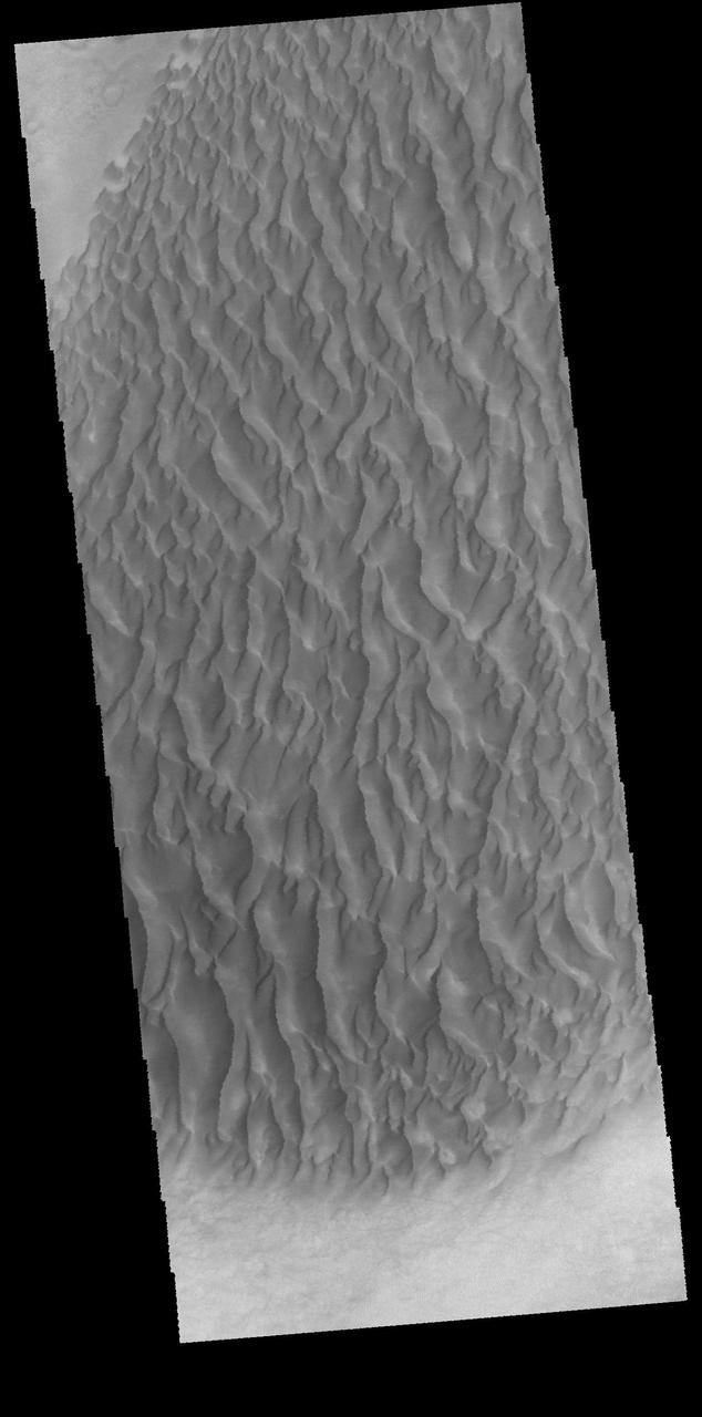
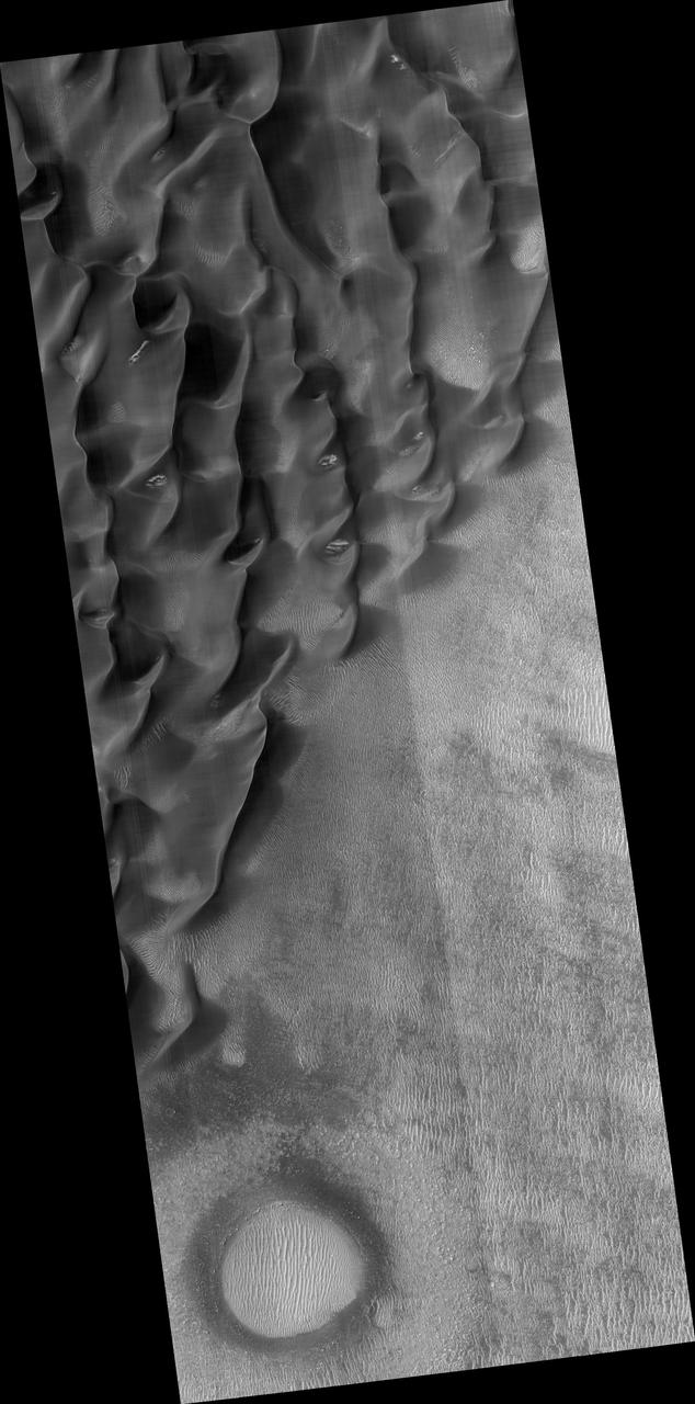
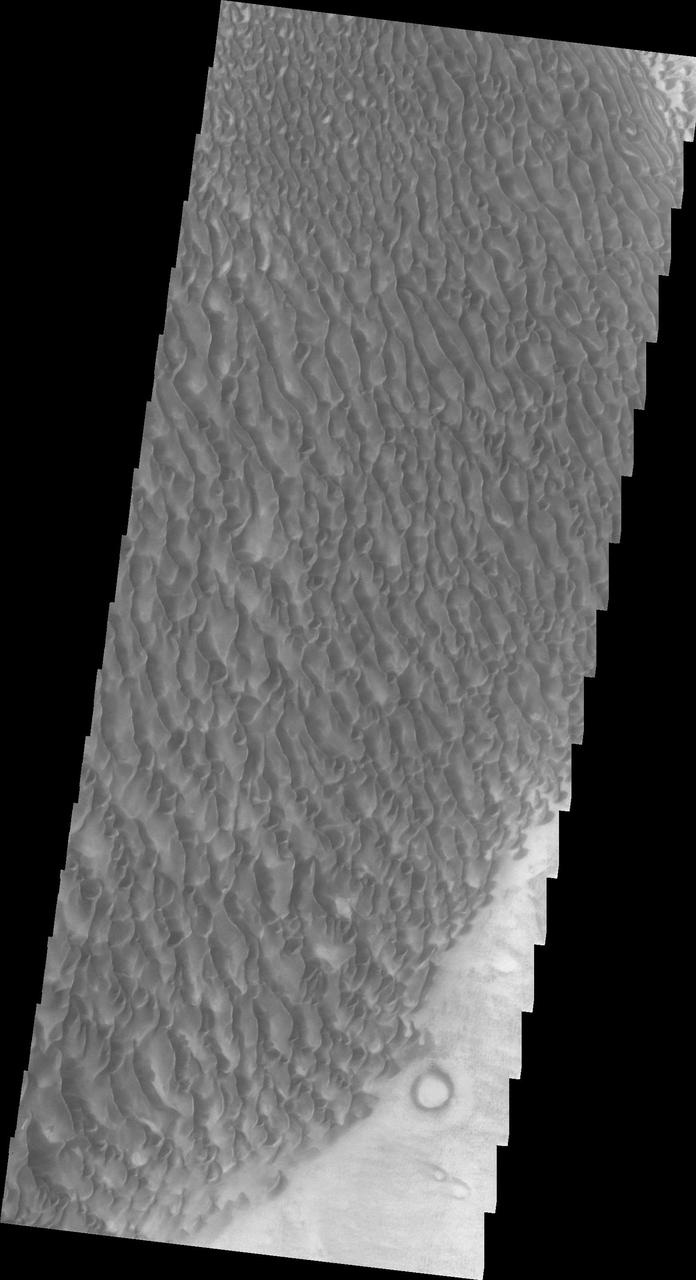
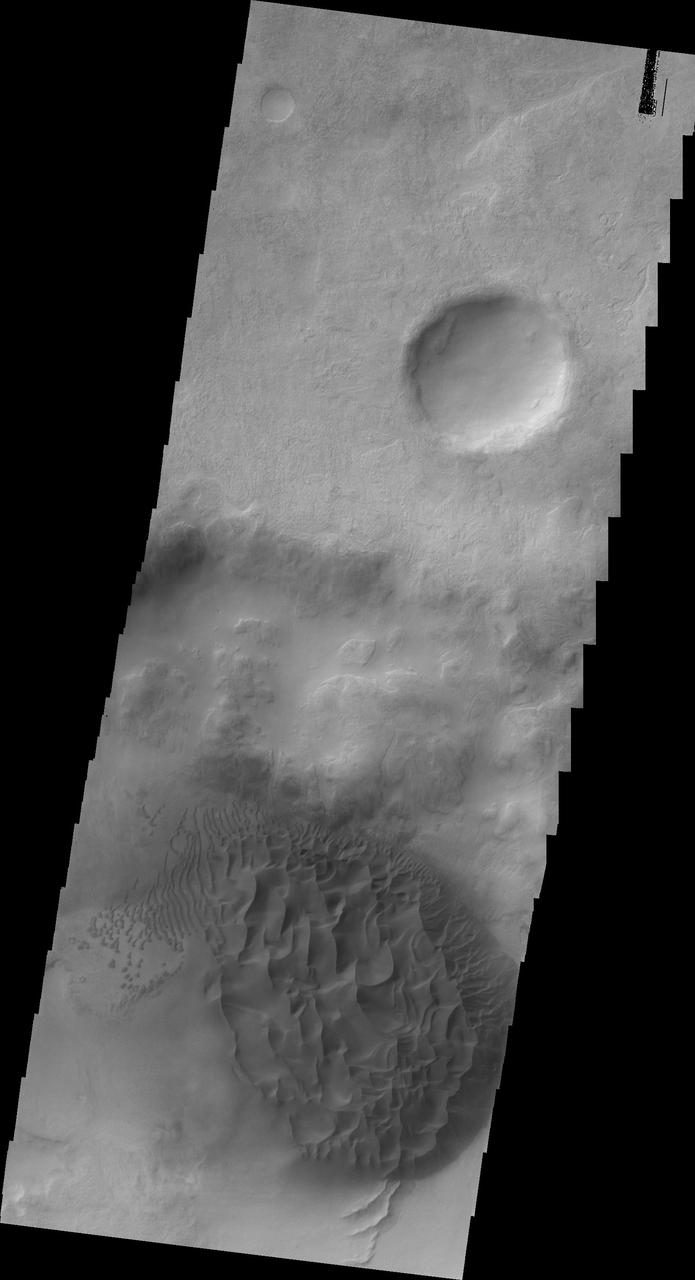
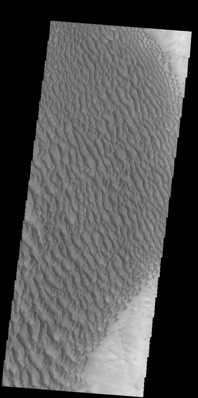
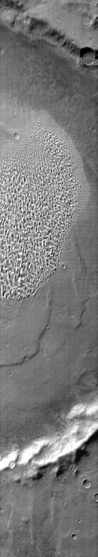
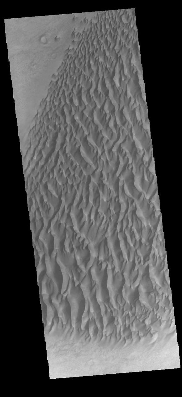
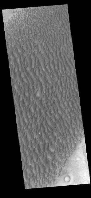
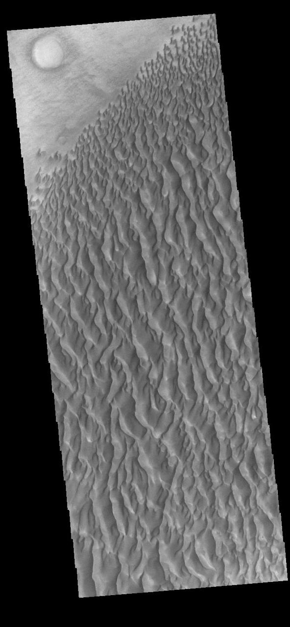
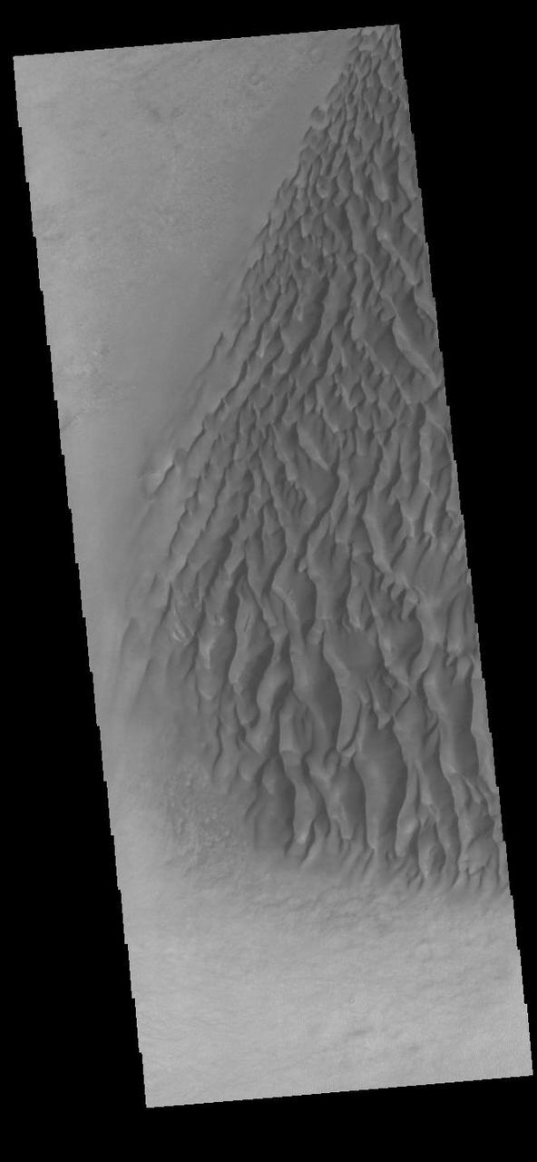
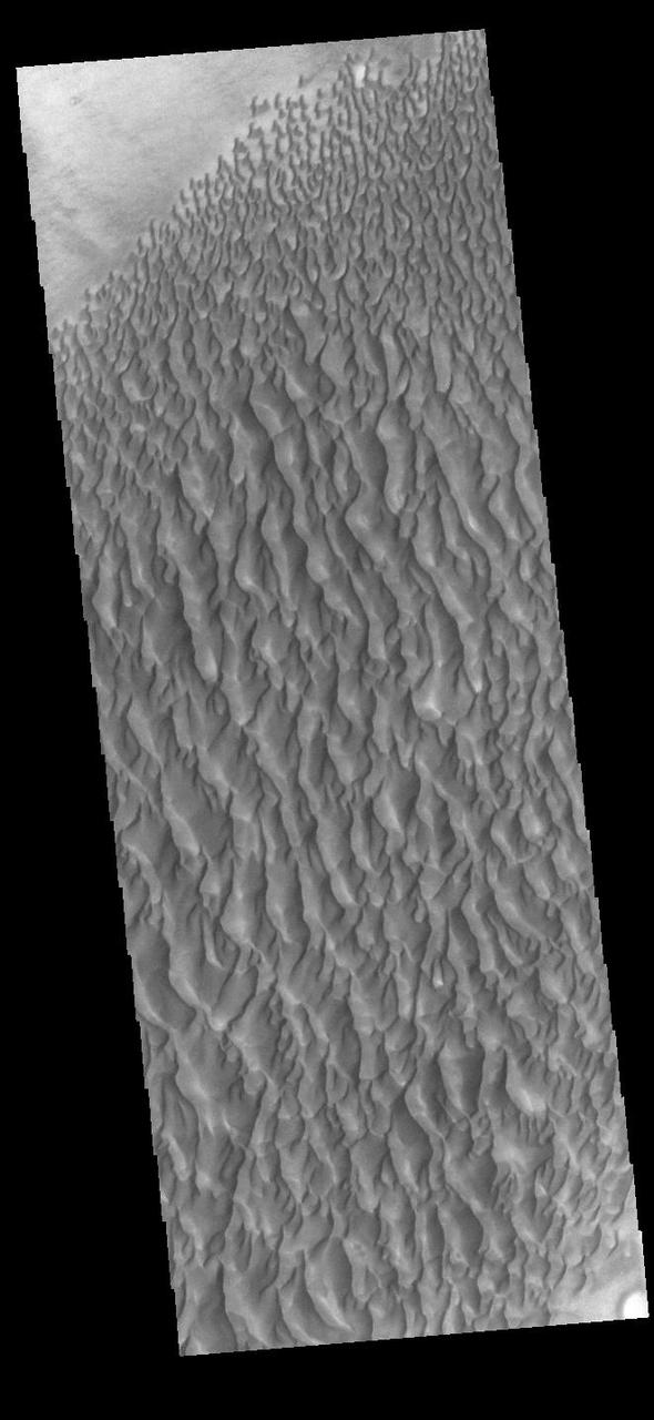
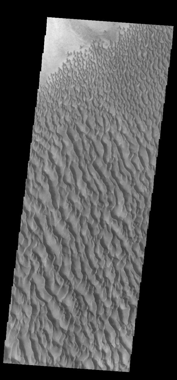
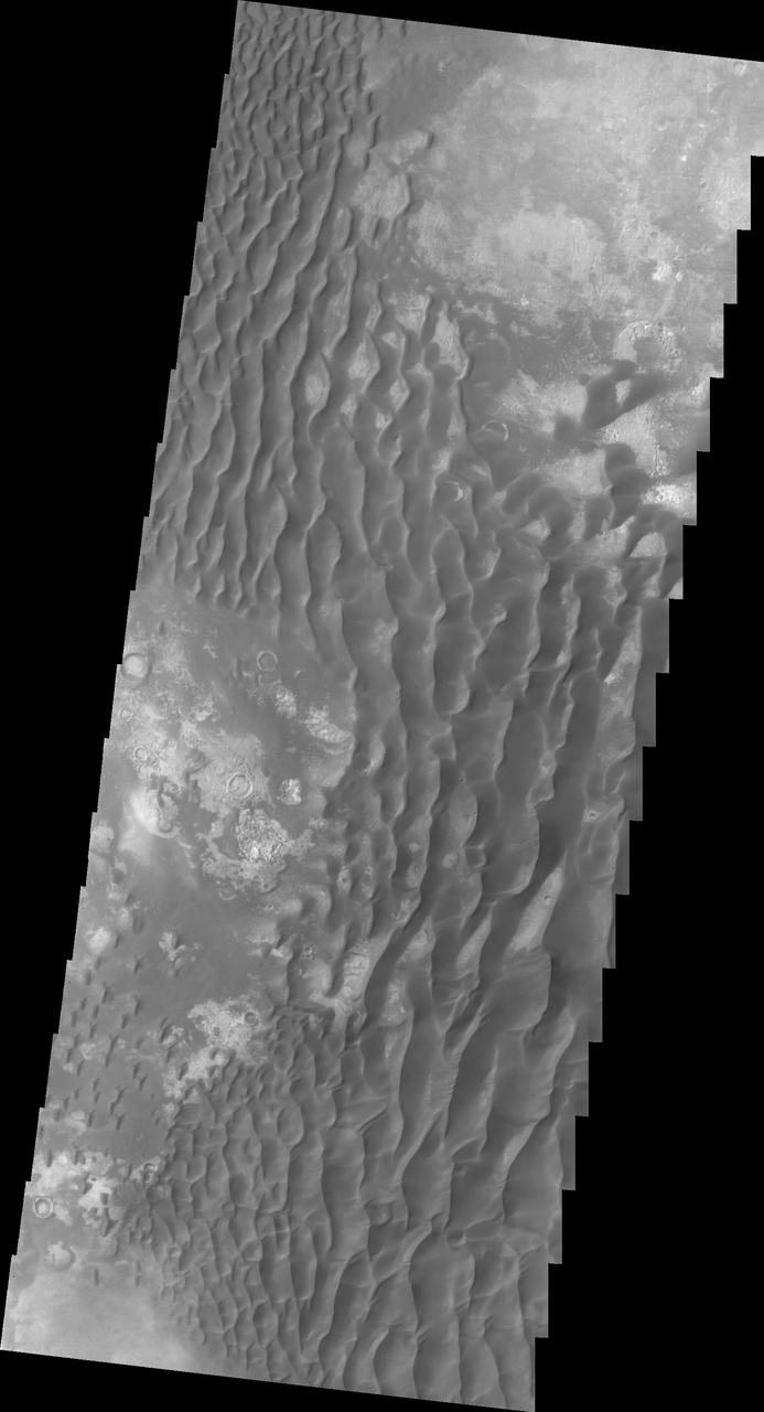
This VIS image shows part of the large sand sheet within Proctor Crater. The surface of the sand sheet hosts dune forms. Orbit Number: 65317 Latitude: -47.7498 Longitude: 30.1831 Instrument: VIS Captured: 2016-09-04 01:02 http://photojournal.jpl.nasa.gov/catalog/PIA21153
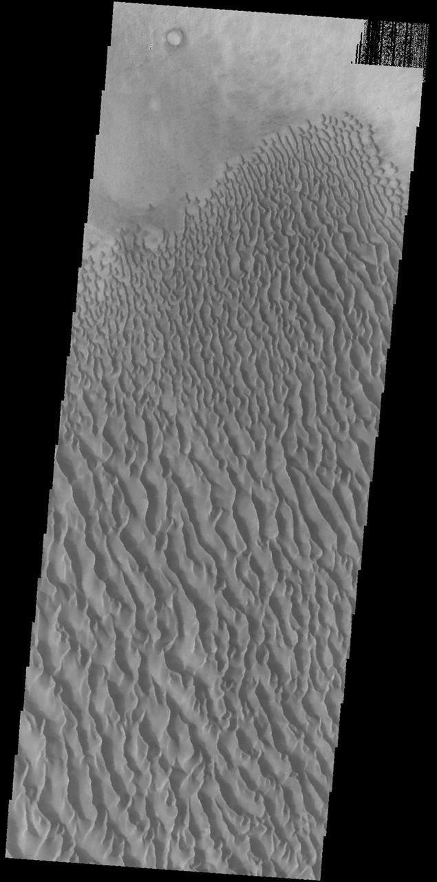
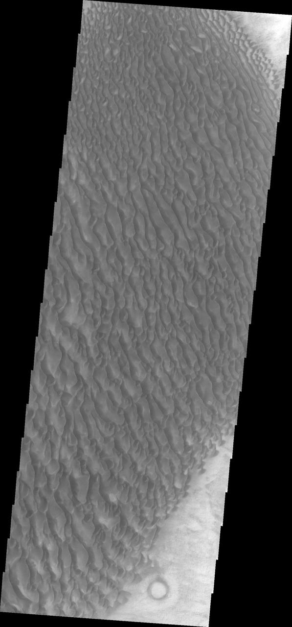
This image captured by NASA's 2001 Mars Odyssey spacecraft shows a portion of the dune sheet and other dune forms on the floor of Proctor Crater. Orbit Number: 67406 Latitude: -47.2898 Longitude: 30.5462 Instrument: VIS Captured: 2017-02-23 03:04 https://photojournal.jpl.nasa.gov/catalog/PIA21657

The THEMIS camera contains 5 filters. Data from different filters can be combined in many ways to create a false color image. These false color images may reveal subtle variations of the surface not easily identified in a single band image. This image from NASA 2001 Mars Odyssey spacecraft shows part of the sand sheet with surface dune forms on Proctor Crater. Proctor Crater is located in Noachis Terra. Orbit Number: 58904 Latitude: -47.7155 Longitude: 29.9151 Instrument: VIS Captured: 2015-03-25 21:18 https://photojournal.jpl.nasa.gov/catalog/PIA21549
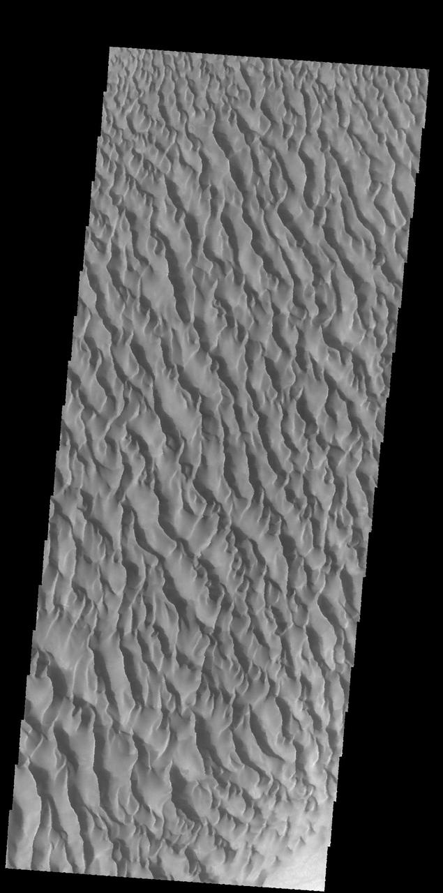
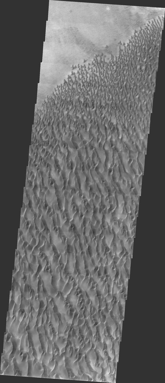
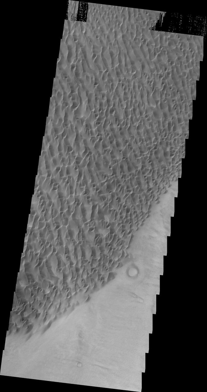
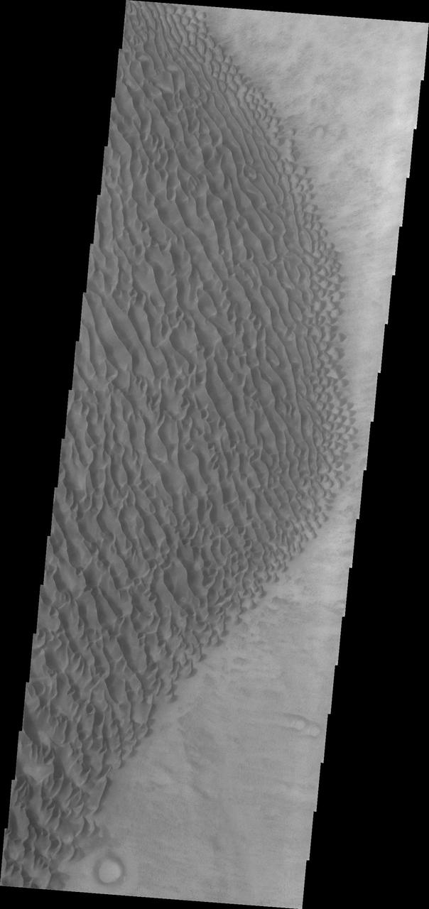
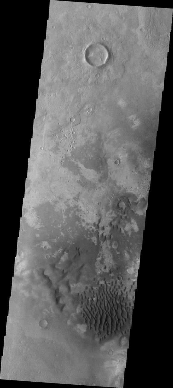
This image captured by NASA 2001 Mars Odyssey spacecraft shows the large dune field located on the floor of Proctor Crater in Noachis Terra. Orbit Number: 66982 Latitude: -47.5876 Longitude: 30.3392 Instrument: VIS Captured: 2017-01-19 04:39 http://photojournal.jpl.nasa.gov/catalog/PIA21503
Dune Activity in Proctor Crater
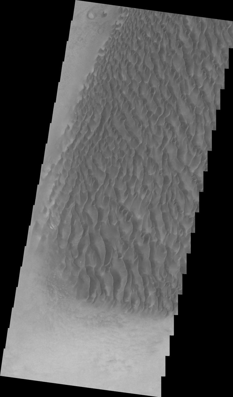
Proctor Crater Dune Field
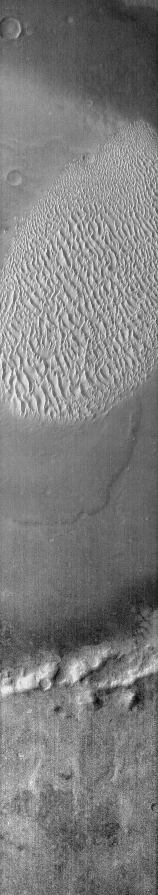
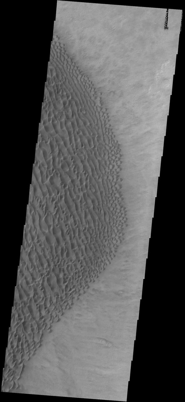
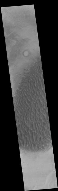
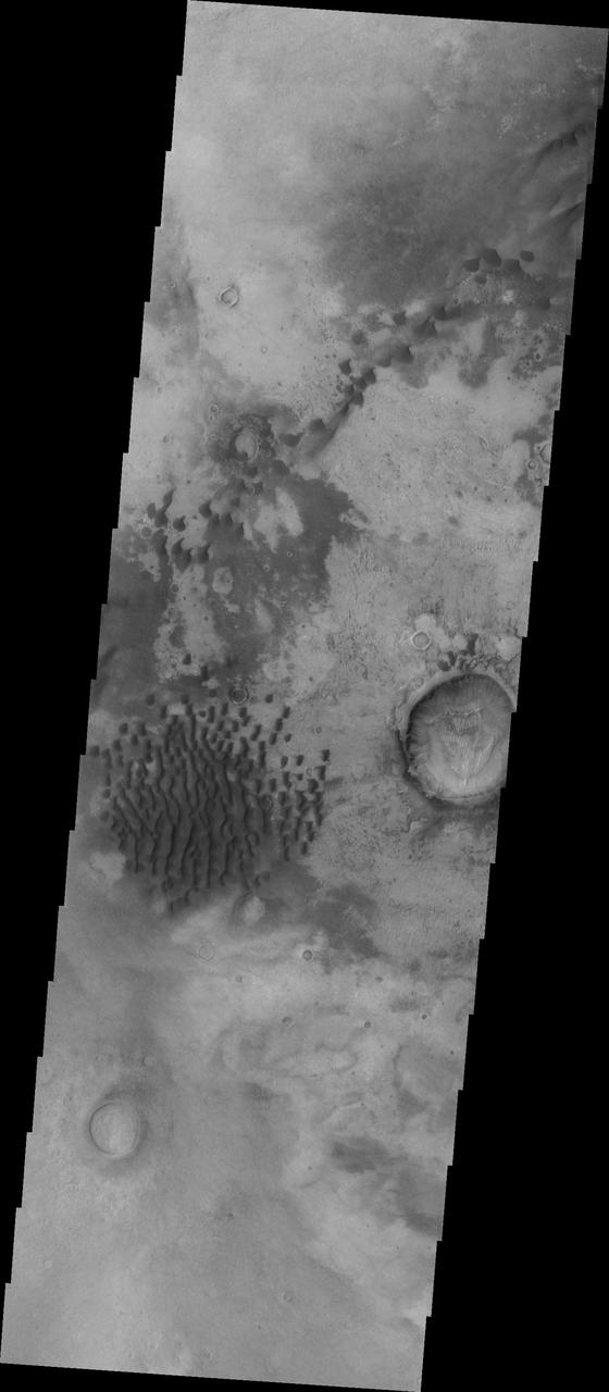
Dunes Southeast of Proctor Crater
Proctor Crater Dunes
Proctor Crater Dunes VIS

Proctor Crater Dunes IR
The THEMIS camera contains 5 filters. The data from different filters can be combined in multiple ways to create a false color image. This image from NASA's 2001 Mars Odyssey spacecraft shows a part of the large sand sheet on the floor of Proctor Crater in Noachis Terra. Orbit Number: 57787 Latitude: -47.7327 Longitude: 30.2888 Instrument: VIS Captured: 2014-12-23 21:29 https://photojournal.jpl.nasa.gov/catalog/PIA21538
Winter View of Dunes in Proctor Crater
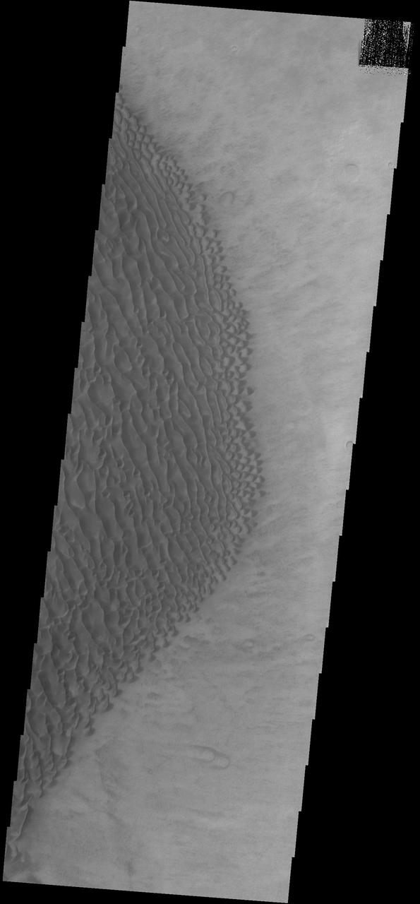
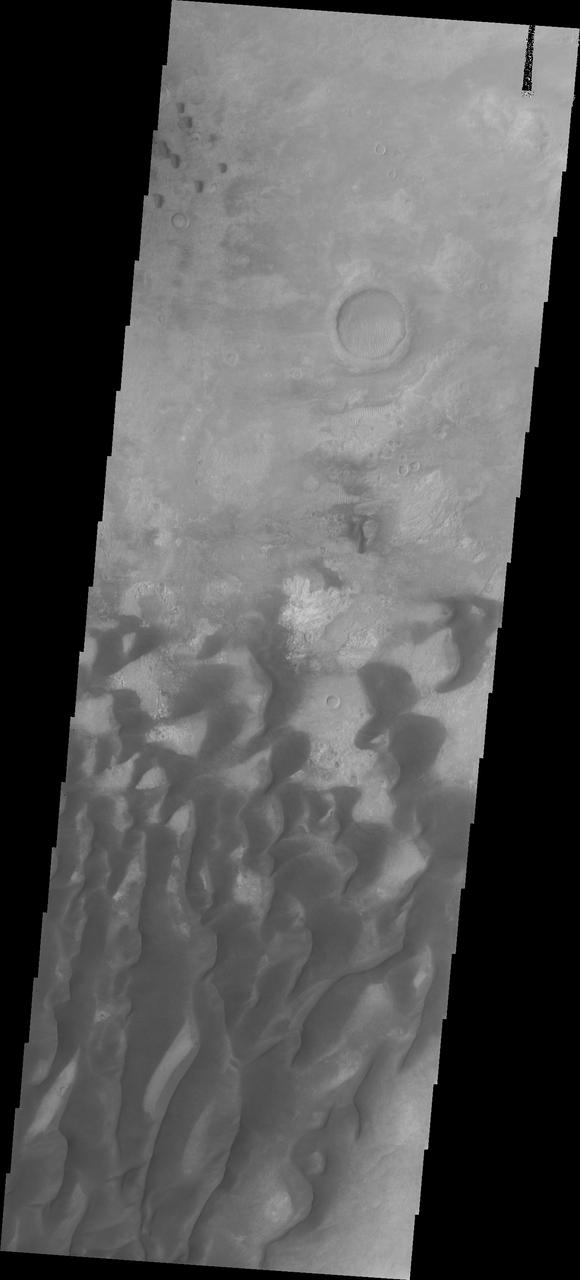
This Mars Odyssey image shows the eastern part of the Proctor Crater dune field.
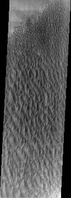
This VIS image shows part of the extensive dune field on the floor of Proctor Crater. Proctor Crater is located in Noachis Terra. Orbit Number: 74883 Latitude: -47.6285 Longitude: 30.2768 Instrument: VIS Captured: 2018-11-01 03:03 https://photojournal.jpl.nasa.gov/catalog/PIA22891
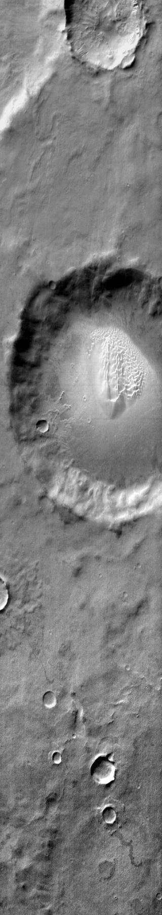
The dune field in this image taken by NASA 2001 Mars Odyssey is located on the floor of an unnamed crater east of Proctor Crater.

This Mars Odyssey mage shows the eastern part of the Proctor Crater dune field. The dunes are warm bright in this image.
Sand Dunes and Ripples in Proctor Crater, Mars
This infrared image of Proctor Crater shows the dune field on the floor of the crater. The dunes are bright in this daytime image, indicating they are warmer than the surrounding crater materials.
This image shows part of the dune field located on the floor of Proctor Crater as seen by NASA 2001 Mars Odyssey spacecraft.
This image captured by NASA 2001 Mars Odyssey spacecraft shows part of the large dune field on the floor of Proctor Crater.

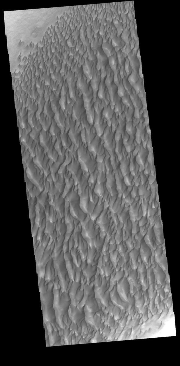
The floor of Proctor Crater is host to this sand sheet and its surface dune forms in this image captured by NASA Mars Odyssey.
This image from NASA 2001 Mars Odyssey shows dunes located on the floor of Proctor Crater.
This image captured by NASA 2001 Mars Odyssey spacecraft shows part of the dune field on the floor of Proctor Crater.
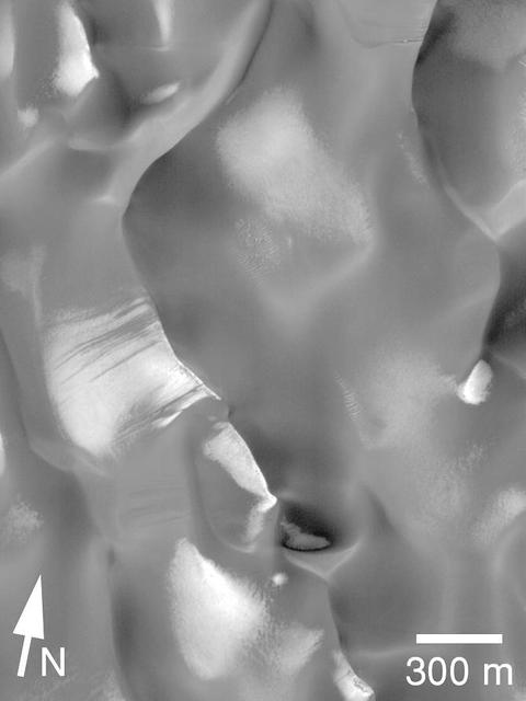
NASA's Mars Reconnaissance Rover (MRO) has observed two types of wind (aeolian) features in Proctor Crater: large, dark features that are sand dunes, made up of basaltic particles, and smaller, light-toned ripples that we call "TAR," or "transverse aeolian ridges." The origin of the TARs is a mystery. They might be dust deposits, or perhaps coarse grained ripples that are coated in bright dust. These TARs are less than 10 meters tall, and are much smaller than the sand dunes that reach impressive heights of over 130 meters. In other places on Mars, TARs are generally older than sand dunes, but here in Proctor Crater, it is not so obvious. How can we tell which came first, the TARs or the dunes? The dunes are situated on top of the TARs, and with this information, we can say the dunes are clearly the younger formations here in Proctor Crater. Fortunately, HiRISE has a tool that can solve this riddle. By taking stereo images of the same region from two different locations, we can estimate the topography of the region by measuring the displacement of surface features from one picture to the other. The result is a quantitative estimate of the local surface topography, called a digital terrain model. The dunes are situated on top of the TARs, and with this information, we can say the dunes are clearly the younger formations here in Proctor Crater. https://photojournal.jpl.nasa.gov/catalog/PIA22040
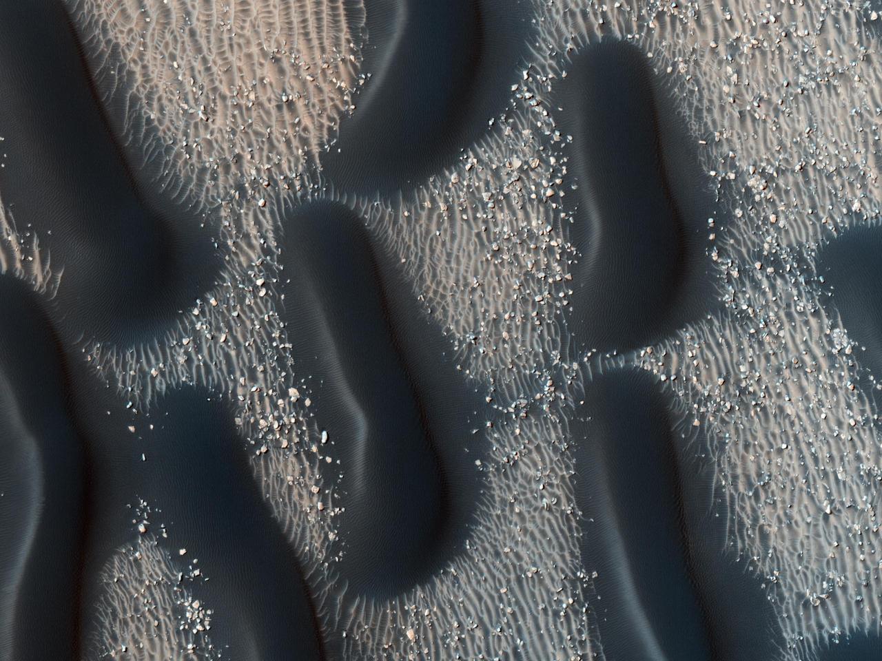
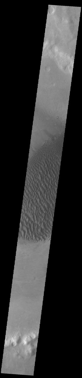
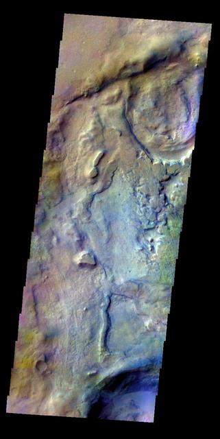
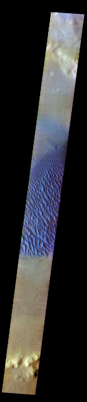
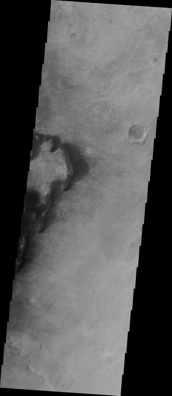
This observation from NASA Mars Reconnaissance Orbiter shows the edge of a dark dune field on the floor of Proctor Crater in the Southern highlands of Mars. The dark dunes are composed of basaltic sand that has collected on the bottom of the crater.
This image captured by NASA Mars Reconnaissance Orbiter shows the edge of a dark dune field on the floor of Proctor Crater, a 150 kilometer diameter crater in the southern highlands of Mars.

The dunes in this daytime IR image from NASA 2001 Mars Odyssey spacecraft appear bright because they are warmer than the surrounding crater materials. These dunes are located on the floor of Proctor Crater.
This image of the floor of Proctor Crater, taken by NASA 2001 Mars Odyssey spacecraft, shows part of the sand sheet and dune forms that are located there.
This image from NASA 2001 Mars Odyssey spacecraft shows part of the large sand sheet and surface dune forms on the floor of Proctor Crater.
This daytime infrared image taken by NASA 2001 Mars Odyssey spacecraft shows part of the dune field located on the floor of Proctor Crater.
This image captured by NASA 2001 Mars Odyssey spacecraft shows part of the large sand sheet and sand dunes on the floor of Proctor Crater.
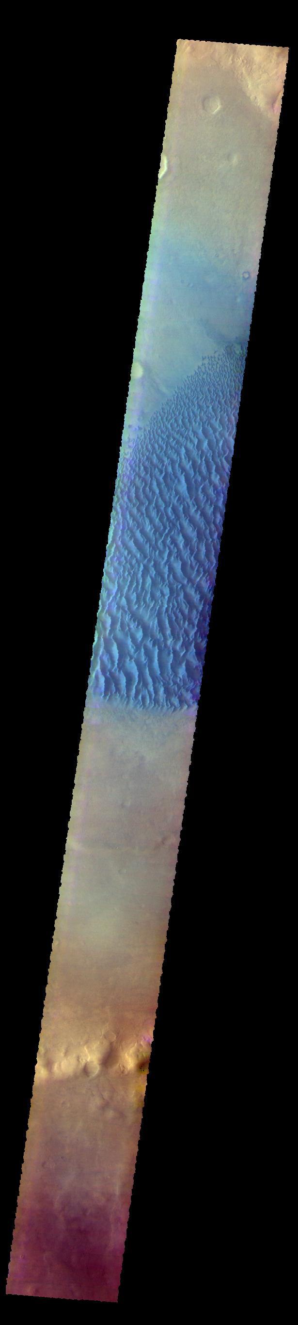
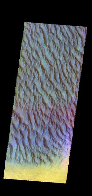
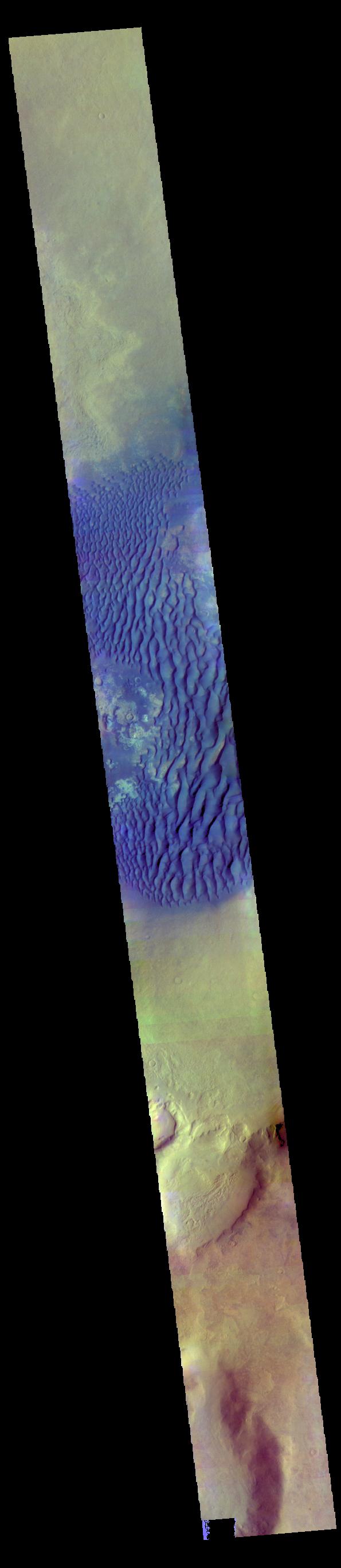
The THEMIS VIS camera contains 5 filters. The data from different filters can be combined in multiple ways to create a false color image. These false color images may reveal subtle variations of the surface not easily identified in a single band image. Today's false color image shows the floor of Proctor Crater, including the large dune field. Basaltic sands are typically blue in false color images. Proctor Crater is located in Noachis Terra. Orbit Number: 59946 Latitude: -47.9086 Longitude: 30.1317 Instrument: VIS Captured: 2015-06-19 16:07 https://photojournal.jpl.nasa.gov/catalog/PIA22670
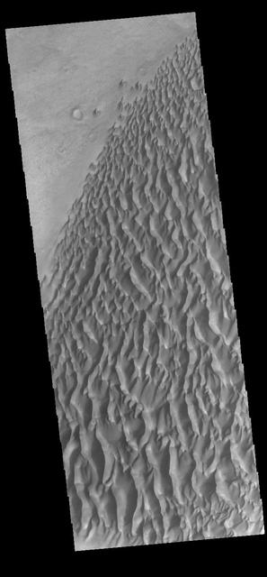
This image captured by NASA 2001 Mars Odyssey spacecraft shows part of the dune field on the floor of Proctor Crater. Orbit Number: 58592 Latitude: -47.7341 Longitude: 30.1 Instrument: VIS Captured: 2015-02-28 04:43 http://photojournal.jpl.nasa.gov/catalog/PIA19433
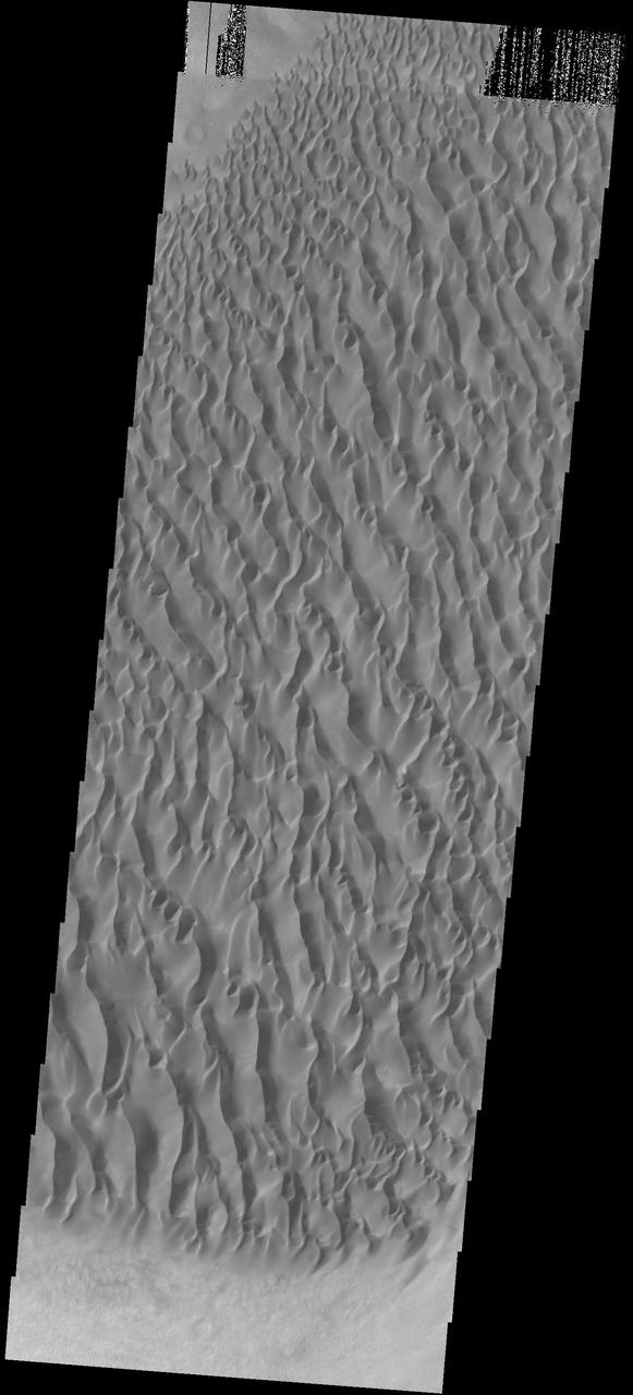
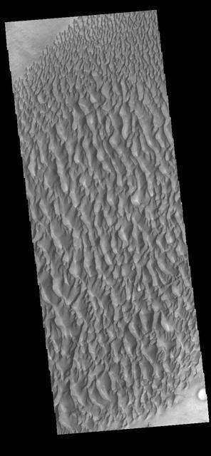
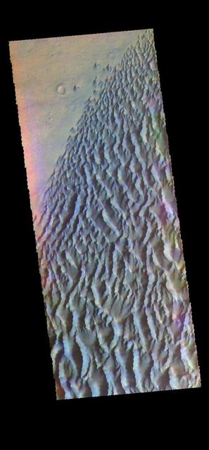
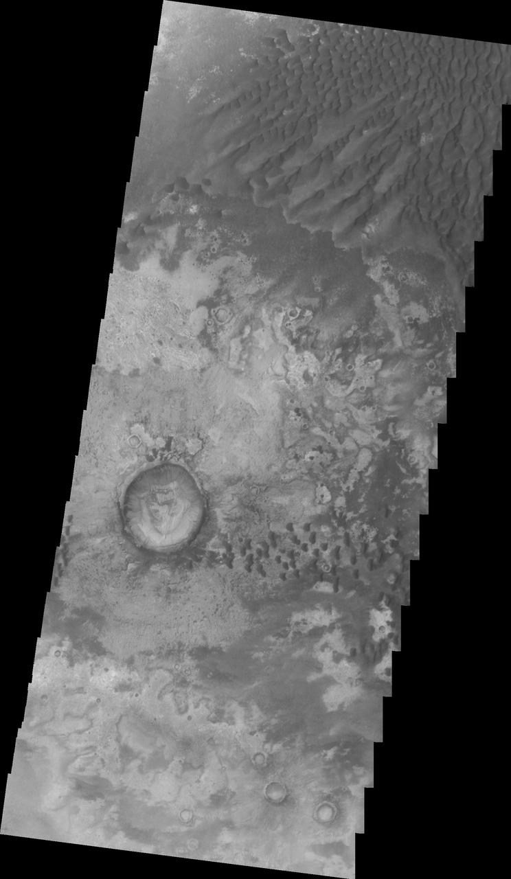
This VIS image displays sand dunes within Proctor Crater. These dunes are composed of basaltic sand that has collected in the bottom of the crater. The topographic depression of the crater forms a sand trap that prevents the sand from escaping. Dune fields are common in the bottoms of craters on Mars and appear as dark splotches that often lean up against the downwind walls of the craters. Dunes are useful for studying both the geology and meteorology of Mars. The sand forms by erosion of larger rocks, but it is unclear when and where this erosion took place on Mars or how such large volumes of sand could be formed. The dunes also indicate the local wind directions by their morphology. In this case, there are few clear slipfaces that would indicate the downwind direction. The crests of the dunes also typically run north-south in the image. This dune form indicates that there are probably two prevailing wind directions that run east and west (left to right and right to left). Proctor Crater is located in Noachis Terra and is 168 km (104 miles) in diameter. Orbit Number: 92103 Latitude: -47.6832 Longitude: 30.1021 Instrument: VIS Captured: 2022-09-19 01:21 https://photojournal.jpl.nasa.gov/catalog/PIA25746
This image displays sand dunes within Proctor Crater. These dunes are composed of basaltic sand that has collected in the bottom of the crater. The topographic depression of the crater forms a sand trap that prevents the sand from escaping. Dune fields are common in the bottoms of craters on Mars and appear as dark splotches that lean up against the downwind walls of the craters. Dunes are useful for studying both the geology and meteorology of Mars. The sand forms by erosion of larger rocks, but it is unclear when and where this erosion took place on Mars or how such large volumes of sand could be formed. The dunes also indicate the local wind directions by their morphology. In this case, there are few clear slipfaces that would indicate the downwind direction. The crests of the dunes also typically run north-south in the image. This dune form indicates that there are probably two prevailing wind directions that run east and west (left to right and right to left). Proctor Crater is located in Noachis Terra and is 168 km (104 miles) in diameter. Orbit Number: 82719 Latitude: -47.5005 Longitude: 30.5331 Instrument: VIS Captured: 2020-08-07 09:19 https://photojournal.jpl.nasa.gov/catalog/PIA24152
This VIS image displays sand dunes within Proctor Crater. These dunes are composed of basaltic sand that has collected in the bottom of the crater. The topographic depression of the crater forms a sand trap that prevents the sand from escaping. Dune fields are common in the bottoms of craters on Mars and appear as dark splotches that often lean up against the downwind walls of the craters. Dunes are useful for studying both the geology and meteorology of Mars. The sand forms by erosion of larger rocks, but it is unclear when and where this erosion took place on Mars or how such large volumes of sand could be formed. The dunes also indicate the local wind directions by their morphology. In this case, there are few clear slipfaces that would indicate the downwind direction. The crests of the dunes also typically run north-south in the image. This dune form indicates that there are probably two prevailing wind directions that run east and west (left to right and right to left). Proctor Crater is located in Noachis Terra and is 168 km (104 miles) in diameter. Orbit Number: 90069 Latitude: -47.5035 Longitude: 30.2656 Instrument: VIS Captured: 2022-04-04 13:50 https://photojournal.jpl.nasa.gov/catalog/PIA25469
This VIS image displays sand dunes within Proctor Crater. These dunes are composed of basaltic sand that has collected in the bottom of the crater. The topographic depression of the crater forms a sand trap that prevents the sand from escaping. Dune fields are common in the bottoms of craters on Mars and appear as dark splotches that often lean up against the downwind walls of the craters. Dunes are useful for studying both the geology and meteorology of Mars. The sand forms by erosion of larger rocks, but it is unclear when and where this erosion took place on Mars or how such large volumes of sand could be formed. The dunes also indicate the local wind directions by their morphology. In this case, there are few clear slipfaces that would indicate the downwind direction. The crests of the dunes also typically run north-south in the image. This dune form indicates that there are probably two prevailing wind directions that run east and west (left to right and right to left). Proctor Crater is located in Noachis Terra and is 168 km (104 miles) in diameter. Orbit Number: 91816 Latitude: -47.7614 Longitude: 29.9278 Instrument: VIS Captured: 2022-08-26 10:12 https://photojournal.jpl.nasa.gov/catalog/PIA25646
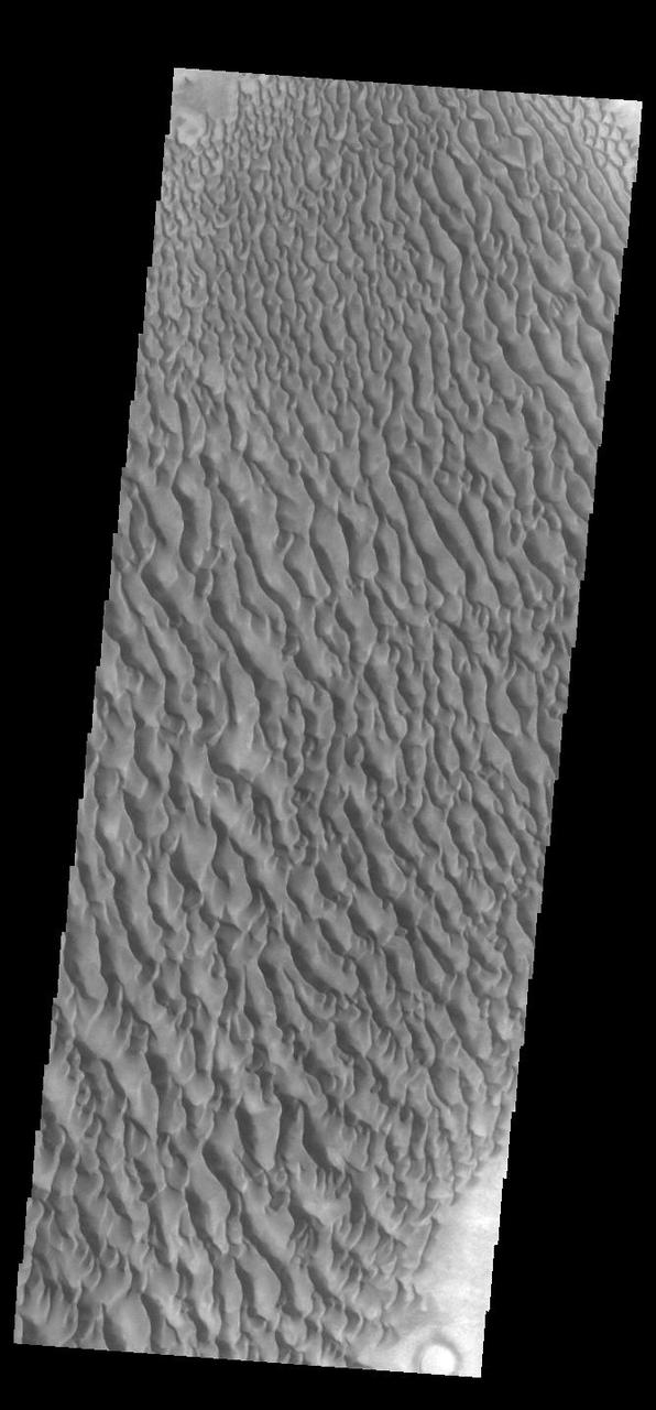
This VIS image displays sand dunes within Proctor Crater. These dunes are composed of basaltic sand that has collected in the bottom of the crater. The topographic depression of the crater forms a sand trap that prevents the sand from escaping. Dune fields are common in the bottoms of craters on Mars and appear as dark splotches that often lean up against the downwind walls of the craters. Dunes are useful for studying both the geology and meteorology of Mars. The sand forms by erosion of larger rocks, but it is unclear when and where this erosion took place on Mars or how such large volumes of sand could be formed. The dunes also indicate the local wind directions by their morphology. In this case, there are few clear slipfaces that would indicate the downwind direction. The crests of the dunes also typically run north-south in the image. This dune form indicates that there are probably two prevailing wind directions that run east and west (left to right and right to left). Proctor Crater is located in Noachis Terra and is 168 km (104 miles) in diameter. Orbit Number: 91660 Latitude: -47.4832 Longitude: 30.5852 Instrument: VIS Captured: 2022-08-13 13:28 https://photojournal.jpl.nasa.gov/catalog/PIA25616
This VIS image displays sand dunes within Proctor Crater. These dunes are composed of basaltic sand that has collected in the bottom of the crater. The topographic depression of the crater forms a sand trap that prevents the sand from escaping. Dune fields are common in the bottoms of craters on Mars and appear as dark splotches that lean up against the downwind walls of the craters. Dunes are useful for studying both the geology and meteorology of Mars. The sand forms by erosion of larger rocks, but it is unclear when and where this erosion took place on Mars or how such large volumes of sand could be formed. The dunes also indicate the local wind directions by their morphology. In this case, there are few clear slipfaces that would indicate the downwind direction. The crests of the dunes also typically run north-south in the image. This dune form indicates that there are probably two prevailing wind directions that run east and west (left to right and right to left). Proctor Crater is located in Noachis Terra and is 168 km (104 miles) in diameter. Orbit Number: 90356 Latitude: -47.4835 Longitude: 30.3891 Instrument: VIS Captured: 2022-04-28 05:00 https://photojournal.jpl.nasa.gov/catalog/PIA25475
This VIS image shows sand dunes within Proctor Crater. These dunes are composed of basaltic sand that has collected in the bottom of the crater. The topographic depression of the crater forms a sand trap that prevents the sand from escaping. Dune fields are common in the bottoms of craters on Mars and appear as dark splotches that often lean up against the downwind walls of the craters. Dunes are useful for studying both the geology and meteorology of Mars. The sand forms by erosion of larger rocks, but it is unclear when and where this erosion took place on Mars or how such large volumes of sand could be formed. The dunes also indicate the local wind directions by their morphology. In this case, there are few clear slipfaces that would indicate the downwind direction. The crests of the dunes also typically run north-south in the image. This dune form indicates that there are probably two prevailing wind directions that run east and west (left to right and right to left). Proctor Crater is located in Noachis Terra and is 168 km (104 miles) in diameter. Orbit Number: 91373 Latitude: -47.4558 Longitude: 30.4026 Instrument: VIS Captured: 2022-07-20 22:18 https://photojournal.jpl.nasa.gov/catalog/PIA25537
This VIS image displays sand dunes within Proctor Crater. These dunes are composed of basaltic sand that has collected in the bottom of the crater. The topographic depression of the crater forms a sand trap that prevents the sand from escaping. Dune fields are common in the bottoms of craters on Mars and appear as dark splotches that often lean up against the downwind walls of the craters. Dunes are useful for studying both the geology and meteorology of Mars. The sand forms by erosion of larger rocks, but it is unclear when and where this erosion took place on Mars or how such large volumes of sand could be formed. The dunes also indicate the local wind directions by their morphology. In this case, there are few clear slipfaces that would indicate the downwind direction. The crests of the dunes also typically run north-south in the image. This dune form indicates that there are probably two prevailing wind directions that run east and west (left to right and right to left). Proctor Crater is located in Noachis Terra and is 168 km (104 miles) in diameter. Orbit Number: 93120 Latitude: -47.5698 Longitude: 30.2743 Instrument: VIS Captured: 2022-12-11 18:38 https://photojournal.jpl.nasa.gov/catalog/PIA25819
The THEMIS VIS camera contains 5 filters. The data from different filters can be combined in multiple ways to create a false color image. This false color image from NASA 2001 Mars Odyssey spacecraft shows part of the floor of Proctor Crater.
This image displays sand dunes within Proctor Crater. These dunes are composed of basaltic sand that has collected in the bottom of the crater. The topographic depression of the crater forms a sand trap that prevents the sand from escaping. Dune fields are common in the bottoms of craters on Mars and appear as dark splotches that lean up against the downwind walls of the craters. Dunes are useful for studying both the geology and meteorology of Mars. The sand forms by erosion of larger rocks, but it is unclear when and where this erosion took place on Mars or how such large volumes of sand could be formed. The dunes also indicate the local wind directions by their morphology. In this case, there are few clear slipfaces that would indicate the downwind direction. The crests of the dunes also typically run north-south in the image. This dune form indicates that there are probably two prevailing wind directions that run east and west (left to right and right to left). Orbit Number: 83605 Latitude: -47.5325 Longitude: 30.3915 Instrument: VIS Captured: 2020-10-19 08:09 https://photojournal.jpl.nasa.gov/catalog/PIA24276
This image displays sand dunes within Proctor Crater. These dunes are composed of basaltic sand that has collected in the bottom of the crater. The topographic depression of the crater forms a sand trap that prevents the sand from escaping. Dune fields are common in the bottoms of craters on Mars and appear as dark splotches that lean up against the downwind walls of the craters. Dunes are useful for studying both the geology and meteorology of Mars. The sand forms by erosion of larger rocks, but it is unclear when and where this erosion took place on Mars or how such large volumes of sand could be formed. The dunes also indicate the local wind directions by their morphology. In this case, there are few clear slipfaces that would indicate the downwind direction. The crests of the dunes also typically run north-south in the image. This dune form indicates that there are probably two prevailing wind directions that run east and west (left to right and right to left). Orbit Number: 82145 Latitude: -47.5218 Longitude: 30.1064 Instrument: VIS Captured: 2020-06-21 03:00 https://photojournal.jpl.nasa.gov/catalog/PIA24142
This image from NASA Mars Odyssey spacecraft, located near 30E and 47.5S, displays sand dunes within Proctor Crater. These dunes are composed of basaltic sand that has collected in the bottom of the crater. The topographic depression of the crater forms a sand trap that prevents the sand from escaping. Dune fields are common in the bottoms of craters on Mars and appear as dark splotches that lean up against the downwind walls of the craters. Dunes are useful for studying both the geology and meteorology of Mars. The sand forms by erosion of larger rocks, but it is unclear when and where this erosion took place on Mars or how such large volumes of sand could be formed. The dunes also indicate the local wind directions by their morphology. In this case, there are few clear slipfaces that would indicate the downwind direction. The crests of the dunes also typically run north-south in the image. This dune form indicates that there are probably two prevailing wind directions that run east and west (left to right and right to left). http://photojournal.jpl.nasa.gov/catalog/PIA04011
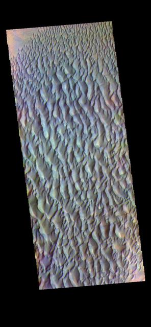
The THEMIS VIS camera contains 5 filters. The data from different filters can be combined in multiple ways to create a false color image. These false color images may reveal subtle variations of the surface not easily identified in a single band image. Today's false color image shows sand dunes within Proctor Crater. These dunes are composed of basaltic sand that has collected in the bottom of the crater. The topographic depression of the crater forms a sand trap that prevents the sand from escaping. Dune fields are common in the bottoms of craters on Mars and appear as dark splotches that lean up against the downwind walls of the craters. Dunes are useful for studying both the geology and meteorology of Mars. The sand forms by erosion of larger rocks, but it is unclear when and where this erosion took place on Mars or how such large volumes of sand could be formed. The dunes also indicate the local wind directions by their morphology. In this case, there are few clear slipfaces that would indicate the downwind direction. The crests of the dunes also typically run north-south in the image. This dune form indicates that there are probably two prevailing wind directions that run east and west (left to right and right to left). Proctor Crater is located in Noachis Terra and is 172km (107miles) in diameter. Orbit Number: 83605 Latitude: -47.5325 Longitude: 30.3915 Instrument: VIS Captured: 2020-10-19 08:09 https://photojournal.jpl.nasa.gov/catalog/PIA24712
The THEMIS VIS camera contains 5 filters. The data from different filters can be combined in multiple ways to create a false color image. These false color images may reveal subtle variations of the surface not easily identified in a single band image. Today's false color image shows Proctor Crater and the large dune field on the crater floor. These dunes are composed of basaltic sand that has collected in the bottom of the crater. The topographic depression of the crater forms a sand trap that prevents the sand from escaping. Dune fields are common in the bottoms of craters on Mars and appear as dark splotches that lean up against the downwind walls of the craters. Dunes are useful for studying both the geology and meteorology of Mars. The sand forms by erosion of larger rocks, but it is unclear when and where this erosion took place on Mars or how such large volumes of sand could be formed. The dunes also indicate the local wind directions by their morphology. In this case, there are few clear slipfaces that would indicate the downwind direction. The crests of the dunes also typically run north-south in the image. This dune form indicates that there are probably two prevailing wind directions that run east and west (left to right and right to left). Proctor Crater is located in Noachis Terra and is 172km (107miles) in diameter. The THEMIS VIS camera is capable of capturing color images of the Martian surface using five different color filters. In this mode of operation, the spatial resolution and coverage of the image must be reduced to accommodate the additional data volume produced from using multiple filters. To make a color image, three of the five filter images (each in grayscale) are selected. Each is contrast enhanced and then converted to a red, green, or blue intensity image. These three images are then combined to produce a full color, single image. Because the THEMIS color filters don't span the full range of colors seen by the human eye, a color THEMIS image does not represent true color. Also, because each single-filter image is contrast enhanced before inclusion in the three-color image, the apparent color variation of the scene is exaggerated. Nevertheless, the color variation that does appear is representative of some change in color, however subtle, in the actual scene. Note that the long edges of THEMIS color images typically contain color artifacts that do not represent surface variation. Orbit Number: 93120 Latitude: -47.5698 Longitude: 30.2743 Instrument: VIS Captured: 2022-12-11 18:38 https://photojournal.jpl.nasa.gov/catalog/PIA26124
The THEMIS VIS camera contains 5 filters. The data from different filters can be combined in multiple ways to create a false color image. These false color images may reveal subtle variations of the surface not easily identified in a single band image. Today's false color image shows part of Proctor Crater in Noachis Terra. Orbit Number: 59659 Latitude: -47.6015 Longitude: 29.5774 Instrument: VIS Captured: 2015-05-27 00:55 https://photojournal.jpl.nasa.gov/catalog/PIA21675

This large dune field is located on the floor of Proctor Crater
The THEMIS VIS camera contains 5 filters. The data from different filters can be combined in multiple ways to create a false color image. These false color images may reveal subtle variations of the surface not easily identified in a single band image. Today's false color image shows part of the dune field on the floor of Proctor Crater. Orbit Number: 58592 Latitude: -47.5967 Longitude: 30.0732 Instrument: VIS Captured: 2015-02-28 04:43 http://photojournal.jpl.nasa.gov/catalog/PIA20074
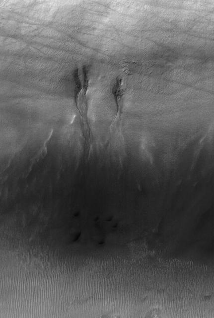
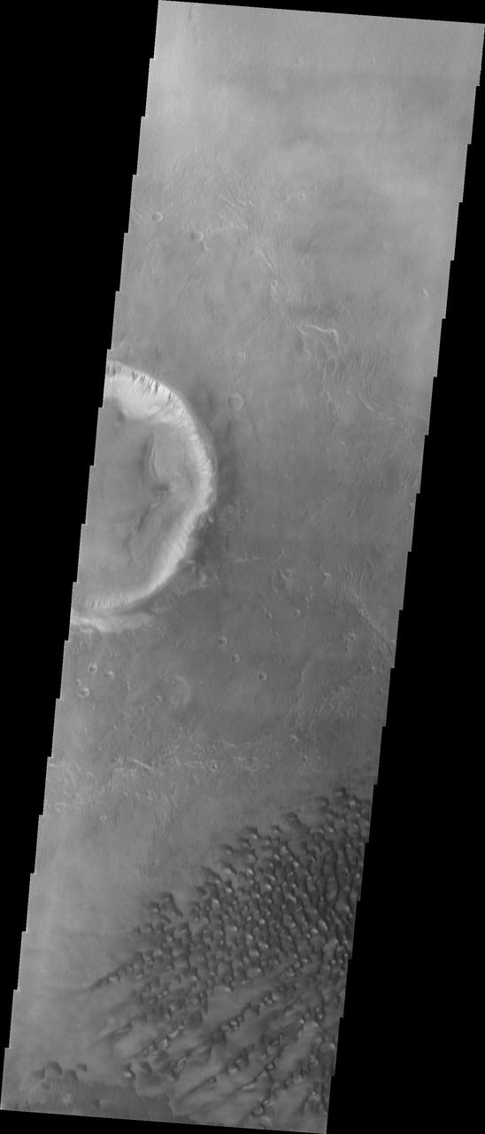
This MOC image shows gullies in the north wall of a crater south of Proctor Crater in Noachis Terra. Dark streaks cutting across the scene were formed by passing dust devils
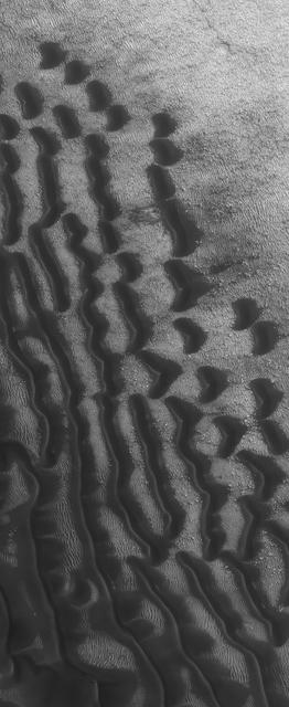
This Mars Global Surveyor MOC image shows dark dunes superposed on the rippled floor of Proctor Crater in Noachis Terra. Winds blowing predominantly from east right to west left were responsible for the formation of these dunes

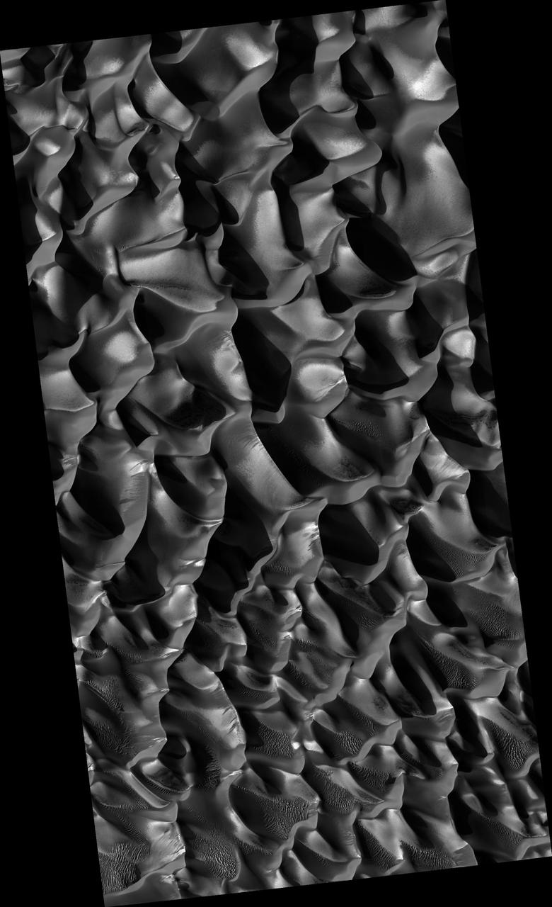
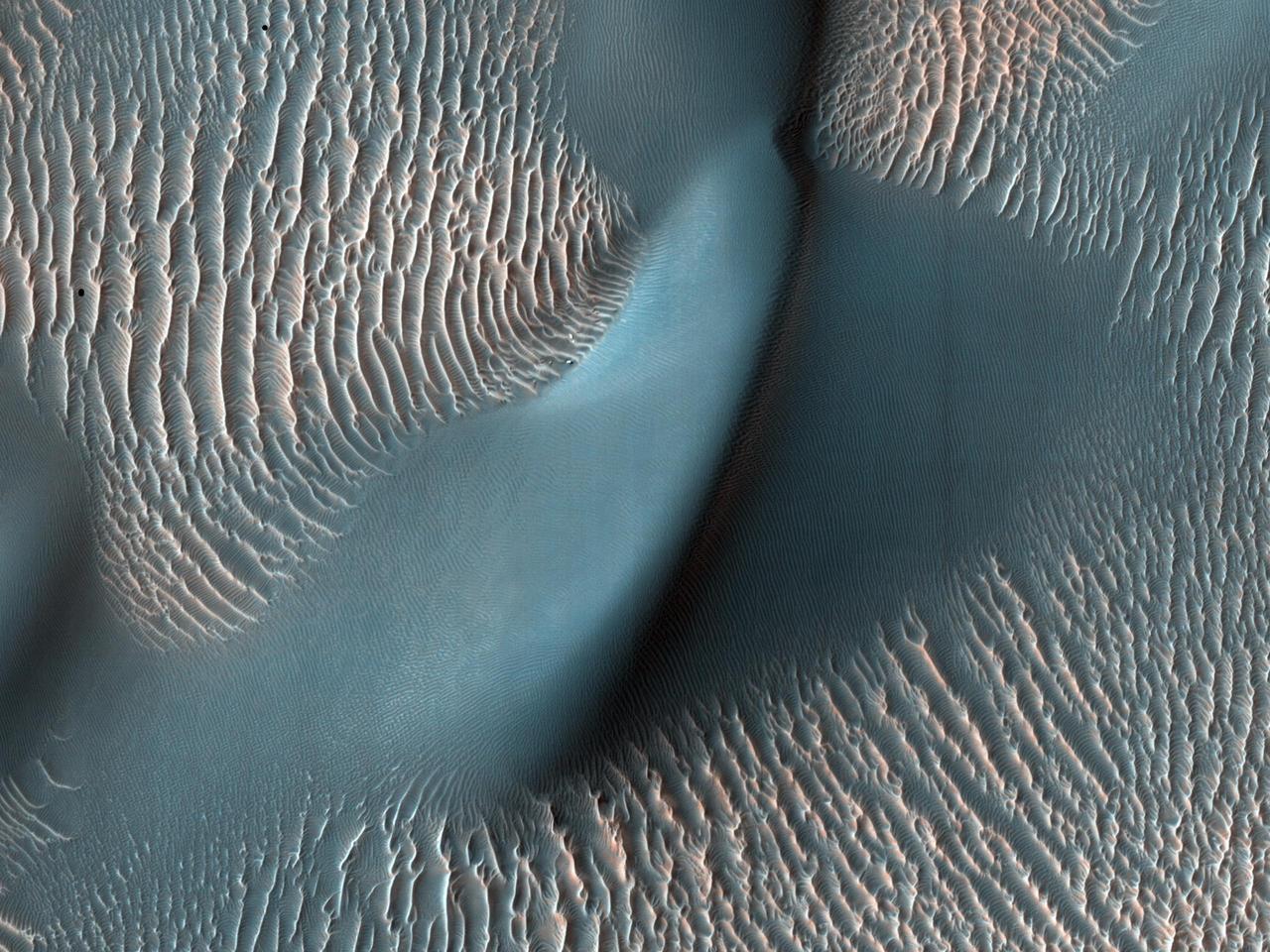
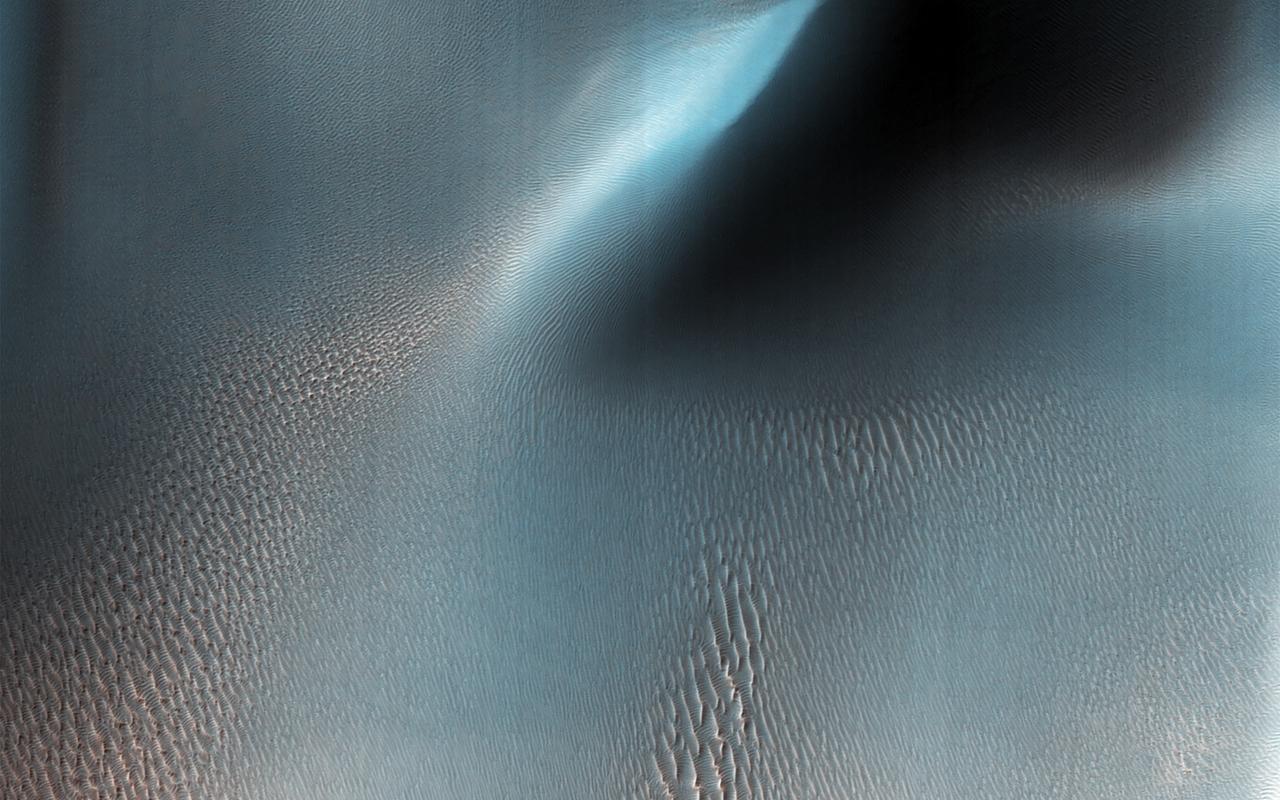
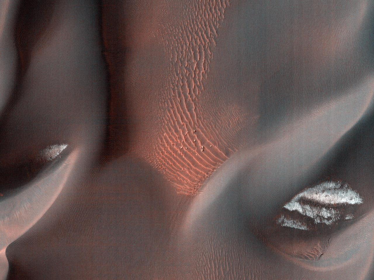
The High Resolution Imaging Science Experiment (HiRISE) camera aboard NASA's Mars Reconnaissance Orbiter captured these sand ripples and the large dune (at center) on Feb. 9, 2009. Color has been added to make textures easier to see. This area is in Proctor Crater at 47.8 degrees south latitude and 30.7 degrees east longitude. https://photojournal.jpl.nasa.gov/catalog/PIA24036

The THEMIS VIS camera contains 5 filters. The data from different filters can be combined in multiple ways to create a false color image. These false color images may reveal subtle variations of the surface not easily identified in a single band image. Today's false color image shows a large dune covered sand sheet on the floor of this unnamed crater in Noachis Terra. Large scale dunes and dune fields cover the floor of many craters in this region west of Hellas Planitia — including Rabe, Proctor, and Matara craters and numerous other unnamed craters. In this false color combination blue indicates basaltic sands. Orbit Number: 67250 Latitude: -49.0136 Longitude: 34.0967 Instrument: VIS Captured: 2017-02-10 07:02 https://photojournal.jpl.nasa.gov/catalog/PIA24058
This VIS image of Kaiser Crater shows a region of the dunes with varied appearances. The different dune forms developed due to different amounts of available sand, different wind directions, and the texture of the crater floor. Dune size, shape, and spacing is controlled by a variety of factors. Note the dune that fills half of the crater in the center of the image. Kaiser Crater is located in the southern hemisphere in the Noachis region west of Hellas Planitia. Kaiser Crater is just one of several large craters with extensive dune fields on the crater floor. Other nearby dune filled craters are Proctor, Russell, and Rabe. Kaiser Crater is 207 km (129 miles) in diameter. The dunes are located in the southern part of the crater floor. The Odyssey spacecraft has spent over 15 years in orbit around Mars, circling the planet more than 71000 times. It holds the record for longest working spacecraft at Mars. THEMIS, the IR/VIS camera system, has collected data for the entire mission and provides images covering all seasons and lighting conditions. Over the years many features of interest have received repeated imaging, building up a suite of images covering the entire feature. From the deepest chasma to the tallest volcano, individual dunes inside craters and dune fields that encircle the north pole, channels carved by water and lava, and a variety of other feature, THEMIS has imaged them all. For the next several months the image of the day will focus on the Tharsis volcanoes, the various chasmata of Valles Marineris, and the major dunes fields. We hope you enjoy these images! Orbit Number: 14953 Latitude: -46.7919 Longitude: 18.4314 Instrument: VIS Captured: 2005-04-28 12:59 https://photojournal.jpl.nasa.gov/catalog/PIA22175
This is a false color image of Kaiser Crater. In this combination of filters "blue" typically means basaltic sand. This VIS image crosses 3/4 of the crater and demonstrates how extensive the dunes are on the floor of Kaiser Crater. Kaiser Crater is located in the southern hemisphere in the Noachis region west of Hellas Planitia. Kaiser Crater is just one of several large craters with extensive dune fields on the crater floor. Other nearby dune filled craters are Proctor, Russell, and Rabe. Kaiser Crater is 207 km (129 miles) in diameter. The dunes are located in the southern part of the crater floor. The THEMIS VIS camera contains 5 filters. The data from different filters can be combined in multiple ways to create a false color image. These false color images may reveal subtle variations of the surface not easily identified in a single band image. The Odyssey spacecraft has spent over 15 years in orbit around Mars, circling the planet more than 71,000 times. It holds the record for longest working spacecraft at Mars. THEMIS, the IR/VIS camera system, has collected data for the entire mission and provides images covering all seasons and lighting conditions. Over the years many features of interest have received repeated imaging, building up a suite of images covering the entire feature. From the deepest chasma to the tallest volcano, individual dunes inside craters and dune fields that encircle the north pole, channels carved by water and lava, and a variety of other feature, THEMIS has imaged them all. For the next several months the image of the day will focus on the Tharsis volcanoes, the various chasmata of Valles Marineris, and the major dunes fields. We hope you enjoy these images! Orbit Number: 66602 Latitude: -47.0551 Longitude: 19.446 Instrument: VIS Captured: 2016-12-18 21:42 https://photojournal.jpl.nasa.gov/catalog/PIA22265
This VIS image of the floor of Kaiser Crater contains a large variety of sand dune shapes and sizes. The "whiter" material is the hard crater floor surface. Kaiser Crater is located in the southern hemisphere in the Noachis region west of Hellas Planitia. Kaiser Crater is just one of several large craters with extensive dune fields on the crater floor. Other nearby dune filled craters are Proctor, Russell, and Rabe. Kaiser Crater is 207 km (129 miles) in diameter. The dunes are located in the southern part of the crater floor. The Odyssey spacecraft has spent over 15 years in orbit around Mars, circling the planet more than 71,000 times. It holds the record for longest working spacecraft at Mars. THEMIS, the IR/VIS camera system, has collected data for the entire mission and provides images covering all seasons and lighting conditions. Over the years many features of interest have received repeated imaging, building up a suite of images covering the entire feature. From the deepest chasma to the tallest volcano, individual dunes inside craters and dune fields that encircle the north pole, channels carved by water and lava, and a variety of other feature, THEMIS has imaged them all. For the next several months the image of the day will focus on the Tharsis volcanoes, the various chasmata of Valles Marineris, and the major dunes fields. We hope you enjoy these images! Orbit Number: 35430 Latitude: -46.8699 Longitude: 19.4731 Instrument: VIS Captured: 2009-12-09 14:09 https://photojournal.jpl.nasa.gov/catalog/PIA22263
This VIS image of Kaiser Crater shows a region of the dunes with varied appearances. The different dune forms developed due to different amounts of available sand, different wind directions, and the texture of the crater floor. The dune forms change from the bottom to the top of the image - large long connected dunes, to large individual dunes, to the very small individual dunes at the top of the image. Kaiser Crater is located in the southern hemisphere in the Noachis region west of Hellas Planitia. Kaiser Crater is just one of several large craters with extensive dune fields on the crater floor. Other nearby dune filled craters are Proctor, Russell, and Rabe. Kaiser Crater is 207 km (129 miles) in diameter. The dunes are located in the southern part of the crater floor. The Odyssey spacecraft has spent over 15 years in orbit around Mars, circling the planet more than 71,000 times. It holds the record for longest working spacecraft at Mars. THEMIS, the IR/VIS camera system, has collected data for the entire mission and provides images covering all seasons and lighting conditions. Over the years many features of interest have received repeated imaging, building up a suite of images covering the entire feature. From the deepest chasma to the tallest volcano, individual dunes inside craters and dune fields that encircle the north pole, channels carved by water and lava, and a variety of other feature, THEMIS has imaged them all. For the next several months the image of the day will focus on the Tharsis volcanoes, the various chasmata of Valles Marineris, and the major dunes fields. We hope you enjoy these images! Orbit Number: 17686 Latitude: -46.6956 Longitude: 19.8394 Instrument: VIS Captured: 2005-12-09 13:25 https://photojournal.jpl.nasa.gov/catalog/PIA22261
This VIS image of Kaiser Crater shows individual dunes and where the dunes have coalesced into longer dune forms. The addition of sand makes the dunes larger and the intra-dune areas go from sand-free to complete coverage of the hard surface of the crater floor. With a continued influx of sand the region will transition from individual dunes to a sand sheet with surface dune forms. Kaiser Crater is located in the southern hemisphere in the Noachis region west of Hellas Planitia. Kaiser Crater is just one of several large craters with extensive dune fields on the crater floor. Other nearby dune filled craters are Proctor, Russell, and Rabe. Kaiser Crater is 207 km (129 miles) in diameter. The dunes are located in the southern part of the crater floor. The Odyssey spacecraft has spent over 15 years in orbit around Mars, circling the planet more than 69000 times. It holds the record for longest working spacecraft at Mars. THEMIS, the IR/VIS camera system, has collected data for the entire mission and provides images covering all seasons and lighting conditions. Over the years many features of interest have received repeated imaging, building up a suite of images covering the entire feature. From the deepest chasma to the tallest volcano, individual dunes inside craters and dune fields that encircle the north pole, channels carved by water and lava, and a variety of other feature, THEMIS has imaged them all. For the next several months the image of the day will focus on the Tharsis volcanoes, the various chasmata of Valles Marineris, and the major dunes fields. We hope you enjoy these images! Orbit Number: 1423 Latitude: -46.9573 Longitude: 18.6192 Instrument: VIS Captured: 2002-04-10 16:44 https://photojournal.jpl.nasa.gov/catalog/PIA22173
This VIS image of Kaiser Crater shows the central part of the crater floor. At the bottom of the image there is a topographic rise. The change in topography has altered the winds in this region, forming a linear pattern at the edge of the high land. Kaiser Crater is located in the southern hemisphere in the Noachis region west of Hellas Planitia. Kaiser Crater is just one of several large craters with extensive dune fields on the crater floor. Other nearby dune filled craters are Proctor, Russell, and Rabe. Kaiser Crater is 207 km (129 miles) in diameter. The dunes are located in the southern part of the crater floor. The Odyssey spacecraft has spent over 15 years in orbit around Mars, circling the planet more than 71000 times. It holds the record for longest working spacecraft at Mars. THEMIS, the IR/VIS camera system, has collected data for the entire mission and provides images covering all seasons and lighting conditions. Over the years many features of interest have received repeated imaging, building up a suite of images covering the entire feature. From the deepest chasma to the tallest volcano, individual dunes inside craters and dune fields that encircle the north pole, channels carved by water and lava, and a variety of other feature, THEMIS has imaged them all. For the next several months the image of the day will focus on the Tharsis volcanoes, the various chasmata of Valles Marineris, and the major dunes fields. We hope you enjoy these images! Orbit Number: 5505 Latitude: -46.2432 Longitude: 19.028 Instrument: VIS Captured: 2003-03-12 17:05 https://photojournal.jpl.nasa.gov/catalog/PIA22174

This VIS image of the floor of Kaiser Crater contains several sand dune shapes and sizes. The "whiter" material is the hard crater floor surface. Kaiser Crater is located in the southern hemisphere in the Noachis region west of Hellas Planitia. Kaiser Crater is just one of several large craters with extensive dune fields on the crater floor. Other nearby dune filled craters are Proctor, Russell, and Rabe. Kaiser Crater is 207 km (129 miles) in diameter. The dunes are located in the southern part of the crater floor. The Odyssey spacecraft has spent over 15 years in orbit around Mars, circling the planet more than 71,000 times. It holds the record for longest working spacecraft at Mars. THEMIS, the IR/VIS camera system, has collected data for the entire mission and provides images covering all seasons and lighting conditions. Over the years many features of interest have received repeated imaging, building up a suite of images covering the entire feature. From the deepest chasma to the tallest volcano, individual dunes inside craters and dune fields that encircle the north pole, channels carved by water and lava, and a variety of other feature, THEMIS has imaged them all. For the next several months the image of the day will focus on the Tharsis volcanoes, the various chasmata of Valles Marineris, and the major dunes fields. We hope you enjoy these images! Orbit Number: 39910 Latitude: -46.9063 Longitude: 19.8112 Instrument: VIS Captured: 2010-12-13 11:17 https://photojournal.jpl.nasa.gov/catalog/PIA22264
Kaiser Crater is located in the southern hemisphere in the Noachis region west of Hellas Planitia. Kaiser Crater is just one of several large craters with extensive dune fields on the crater floor. Other nearby dune filled craters are Proctor, Russell, and Rabe. Kaiser Crater is 207 km (129 miles) in diameter. The dunes are located in the southeastern part of the crater floor. Most of the individual dunes in Kaiser Crater are barchan dunes. Barchan dunes are crescent shaped with the points of the crescent pointing downwind. The sand is blown up the low angle side of the dune and then tumbles down the steep slip face. This dune type forms on hard surfaces where there is limited amounts of sand. Barchan dunes can merge together over time with increased sand in the local area. The Odyssey spacecraft has spent over 15 years in orbit around Mars, circling the planet more than 69000 times. It holds the record for longest working spacecraft at Mars. THEMIS, the IR/VIS camera system, has collected data for the entire mission and provides images covering all seasons and lighting conditions. Over the years many features of interest have received repeated imaging, building up a suite of images covering the entire feature. From the deepest chasma to the tallest volcano, individual dunes inside craters and dune fields that encircle the north pole, channels carved by water and lava, and a variety of other feature, THEMIS has imaged them all. For the next several months the image of the day will focus on the Tharsis volcanoes, the various chasmata of Valles Marineris, and the major dunes fields. We hope you enjoy these images! Orbit Number: 1036 Latitude: -46.7795 Longitude: 20.2075 Instrument: VIS Captured: 2002-03-09 20:07 https://photojournal.jpl.nasa.gov/catalog/PIA22172
At the top of this VIS image crescent shaped dunes are visible. As the dunes approach a break in elevation the forms change to connect the crescents together forming long aligned dune forms. Kaiser Crater is located in the southern hemisphere in the Noachis region west of Hellas Planitia. Kaiser Crater is just one of several large craters with extensive dune fields on the crater floor. Other nearby dune filled craters are Proctor, Russell, and Rabe. Kaiser Crater is 207 km (129 miles) in diameter. The dunes are located in the southern part of the crater floor. The Odyssey spacecraft has spent over 15 years in orbit around Mars, circling the planet more than 71,000 times. It holds the record for longest working spacecraft at Mars. THEMIS, the IR/VIS camera system, has collected data for the entire mission and provides images covering all seasons and lighting conditions. Over the years many features of interest have received repeated imaging, building up a suite of images covering the entire feature. From the deepest chasma to the tallest volcano, individual dunes inside craters and dune fields that encircle the north pole, channels carved by water and lava, and a variety of other feature, THEMIS has imaged them all. For the next several months the image of the day will focus on the Tharsis volcanoes, the various chasmata of Valles Marineris, and the major dunes fields. We hope you enjoy these images! Orbit Number: 34157 Latitude: -46.9336 Longitude: 18.9272 Instrument: VIS Captured: 2009-08-26 18:49 https://photojournal.jpl.nasa.gov/catalog/PIA22262