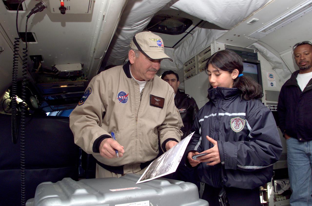
Dr. Tom Mace, NASA DFRC Director of Airborne Sciences, talks with a student from Punta Arenas, Chile, during a tour of the DC-8 aircraft while it was in the country supporting the AirSAR 2004 campaign. AirSAR 2004 is a three-week expedition by an international team of scientists that uses an all-weather imaging tool, called the Airborne Synthetic Aperture Radar (AirSAR) which is located onboard NASA's DC-8 airborne laboratory. Scientists from many parts of the world including NASA's Jet Propulsion Laboratory are combining ground research done in several areas in Central and South America with NASA's AirSAR technology to improve and expand on the quality of research they are able to conduct. In South America and Antarctica, AirSAR collected imagery and data to help determine the contribution of Southern Hemisphere glaciers to sea level rise due to climate change. In Patagonia, researchers found this contribution had more than doubled from 1995 to 2000, compared to the previous 25 years. AirSAR data will make it possible to determine whether that trend is continuing or accelerating. AirSAR will also provide reliable information on ice shelf thickness to measure the contribution of the glaciers to sea level.

NASA Dryden Mission Manager Walter Klein poses with school children that visited the DC-8 during AirSAR 2004 in Punta Arenas, Chile. AirSAR 2004 is a three-week expedition by an international team of scientists that uses an all-weather imaging tool, called the Airborne Synthetic Aperture Radar (AirSAR) which is located onboard NASA's DC-8 airborne laboratory. Scientists from many parts of the world including NASA's Jet Propulsion Laboratory are combining ground research done in several areas in Central and South America with NASA's AirSAR technology to improve and expand on the quality of research they are able to conduct. In South America and Antarctica, AirSAR collected imagery and data to help determine the contribution of Southern Hemisphere glaciers to sea level rise due to climate change. In Patagonia, researchers found this contribution had more than doubled from 1995 to 2000, compared to the previous 25 years. AirSAR data will make it possible to determine whether that trend is continuing or accelerating. AirSAR will also provide reliable information on ice shelf thickness to measure the contribution of the glaciers to sea level.
NASA Dryden Mission Manager Walter Klein talks with school children from Punta Arenas, Chile, during a tour of the DC-8 aircraft while it was in the country supporting the AirSAR 2004 campaign. AirSAR 2004 is a three-week expedition by an international team of scientists that uses an all-weather imaging tool, called the Airborne Synthetic Aperture Radar (AirSAR) which is located onboard NASA's DC-8 airborne laboratory. Scientists from many parts of the world including NASA's Jet Propulsion Laboratory are combining ground research done in several areas in Central and South America with NASA's AirSAR technology to improve and expand on the quality of research they are able to conduct. In South America and Antarctica, AirSAR collected imagery and data to help determine the contribution of Southern Hemisphere glaciers to sea level rise due to climate change. In Patagonia, researchers found this contribution had more than doubled from 1995 to 2000, compared to the previous 25 years. AirSAR data will make it possible to determine whether that trend is continuing or accelerating. AirSAR will also provide reliable information on ice shelf thickness to measure the contribution of the glaciers to sea level.

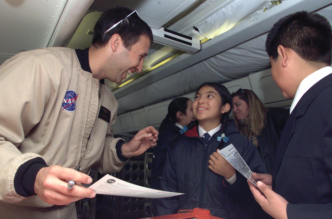
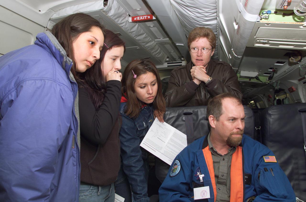
School children from Punta Arenas, Chile, talk with Dr. David Imel, an AirSAR scientist from NASA JPL, during AirSAR 2004. AirSAR 2004 is a three-week expedition by an international team of scientists that uses an all-weather imaging tool, called the Airborne Synthetic Aperture Radar (AirSAR) which is located onboard NASA's DC-8 airborne laboratory. Scientists from many parts of the world including NASA's Jet Propulsion Laboratory are combining ground research done in several areas in Central and South America with NASA's AirSAR technology to improve and expand on the quality of research they are able to conduct. In South America and Antarctica, AirSAR collected imagery and data to help determine the contribution of Southern Hemisphere glaciers to sea level rise due to climate change. In Patagonia, researchers found this contribution had more than doubled from 1995 to 2000, compared to the previous 25 years. AirSAR data will make it possible to determine whether that trend is continuing or accelerating. AirSAR will also provide reliable information on ice shelf thickness to measure the contribution of the glaciers to sea level.
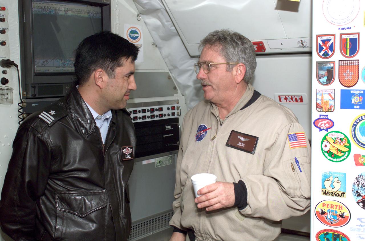
Chilean Air Force Captain Saez and Dr. Tom Mace, DFRC Director of Airborne Sciences, discuss airborne science during a DC-8 ferry flight from Santiago to Punta Arenas, Chile. AirSAR 2004 is a three-week expedition by an international team of scientists that uses an all-weather imaging tool, called the Airborne Synthetic Aperture Radar (AirSAR) which is located onboard NASA's DC-8 airborne laboratory. Scientists from many parts of the world including NASA's Jet Propulsion Laboratory are combining ground research done in several areas in Central and South America with NASA's AirSAR technology to improve and expand on the quality of research they are able to conduct. In South America and Antarctica, AirSAR collected imagery and data to help determine the contribution of Southern Hemisphere glaciers to sea level rise due to climate change. In Patagonia, researchers found this contribution had more than doubled from 1995 to 2000, compared to the previous 25 years. AirSAR data will make it possible to determine whether that trend is continuing or accelerating. AirSAR will also provide reliable information on ice shelf thickness to measure the contribution of the glaciers to sea level.
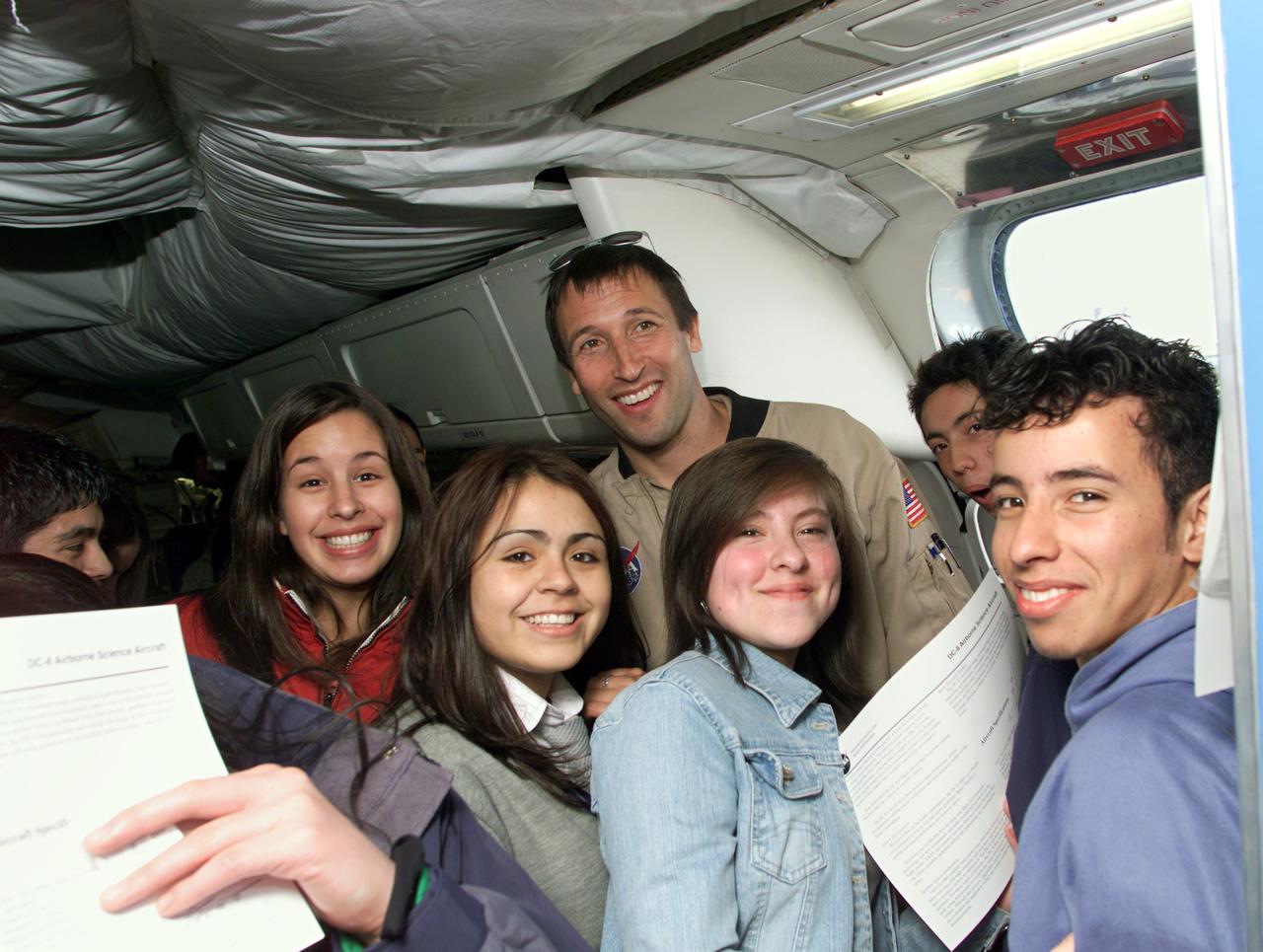
NASA DC-8 Mission Manager Walter Klein poses with a group of Chilean Students onboard the aircraft at Carlos Ibanez del Campo International Airport in Punta Arenas, Chile. AirSAR 2004 is a three-week expedition by an international team of scientists that is using an all-weather imaging tool, called the Airborne Synthetic Aperture Radar (AirSAR) which is located onboard NASA's DC-8 airborne laboratory. Scientists from many parts of the world including NASA's Jet Propulsion Laboratory are combining ground research done in several areas in Central and South America with NASA's AirSAR technology to improve and expand on the quality of research they are able to conduct. In South America and Antarctica, AirSAR will collect imagery and data to help determine the contribution of Southern Hemisphere glaciers to sea level rise due to climate change. In Patagonia, researchers found this contribution had more than doubled from 1995 to 2000, compared to the previous 25 years. AirSAR data will make it possible to determine whether that trend is decreasing, continuing or accelerating. AirSAR will also provide reliable information on ice shelf thickness to measure the contribution of the glaciers to sea level.
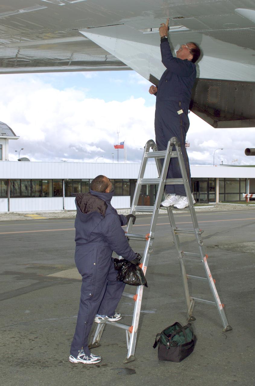
NASA DC-8 Ground Support Technicians Mark Corlew and Mike Lakowski perform routine maintenance on the aircraft at Carlos Ibanez del Campo International Airport in Punta Arenas, Chile. AirSAR 2004 is a three-week expedition by an international team of scientists that is using an all-weather imaging tool, called the Airborne Synthetic Aperture Radar (AirSAR) which is located onboard NASA's DC-8 airborne laboratory. Scientists from many parts of the world including NASA's Jet Propulsion Laboratory are combining ground research done in several areas in Central and South America with NASA's AirSAR technology to improve and expand on the quality of research they are able to conduct. In South America and Antarctica, AirSAR will collect imagery and data to help determine the contribution of Southern Hemisphere glaciers to sea level rise due to climate change. In Patagonia, researchers found this contribution had more than doubled from 1995 to 2000, compared to the previous 25 years. AirSAR data will make it possible to determine whether that trend is decreasing, continuing or accelerating. AirSAR will also provide reliable information on ice shelf thickness to measure the contribution of the glaciers to sea level.
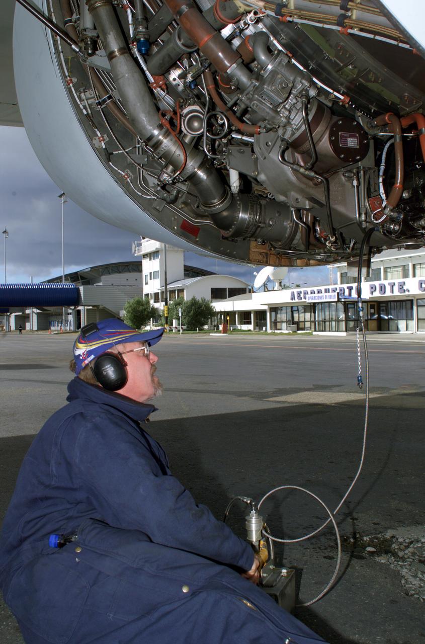
NASA DC-8 Ground Support Technician Joe Niquette performs routine maintenance on the DC-8 aircraft at Carlos Ibanez del Campo International Airport in Punta Arenas, Chile. AirSAR 2004 is a three-week expedition by an international team of scientists that is using an all-weather imaging tool, called the Airborne Synthetic Aperture Radar (AirSAR) which is located onboard NASA's DC-8 airborne laboratory. Scientists from many parts of the world including NASA's Jet Propulsion Laboratory are combining ground research done in several areas in Central and South America with NASA's AirSAR technology to improve and expand on the quality of research they are able to conduct. In South America and Antarctica, AirSAR will collect imagery and data to help determine the contribution of Southern Hemisphere glaciers to sea level rise due to climate change. In Patagonia, researchers found this contribution had more than doubled from 1995 to 2000, compared to the previous 25 years. AirSAR data will make it possible to determine whether that trend is decreasing, continuing or accelerating. AirSAR will also provide reliable information on ice shelf thickness to measure the contribution of the glaciers to sea level.
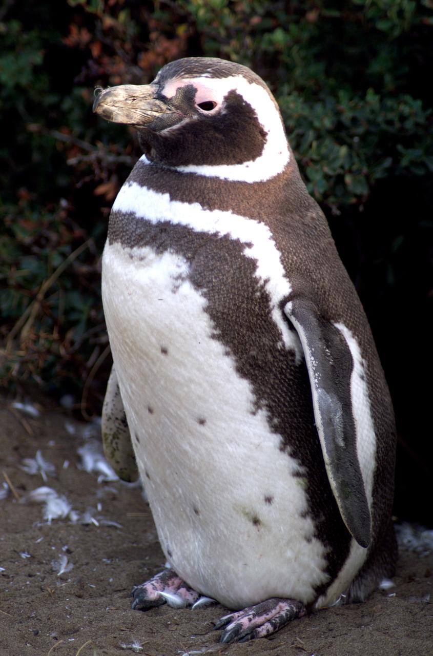
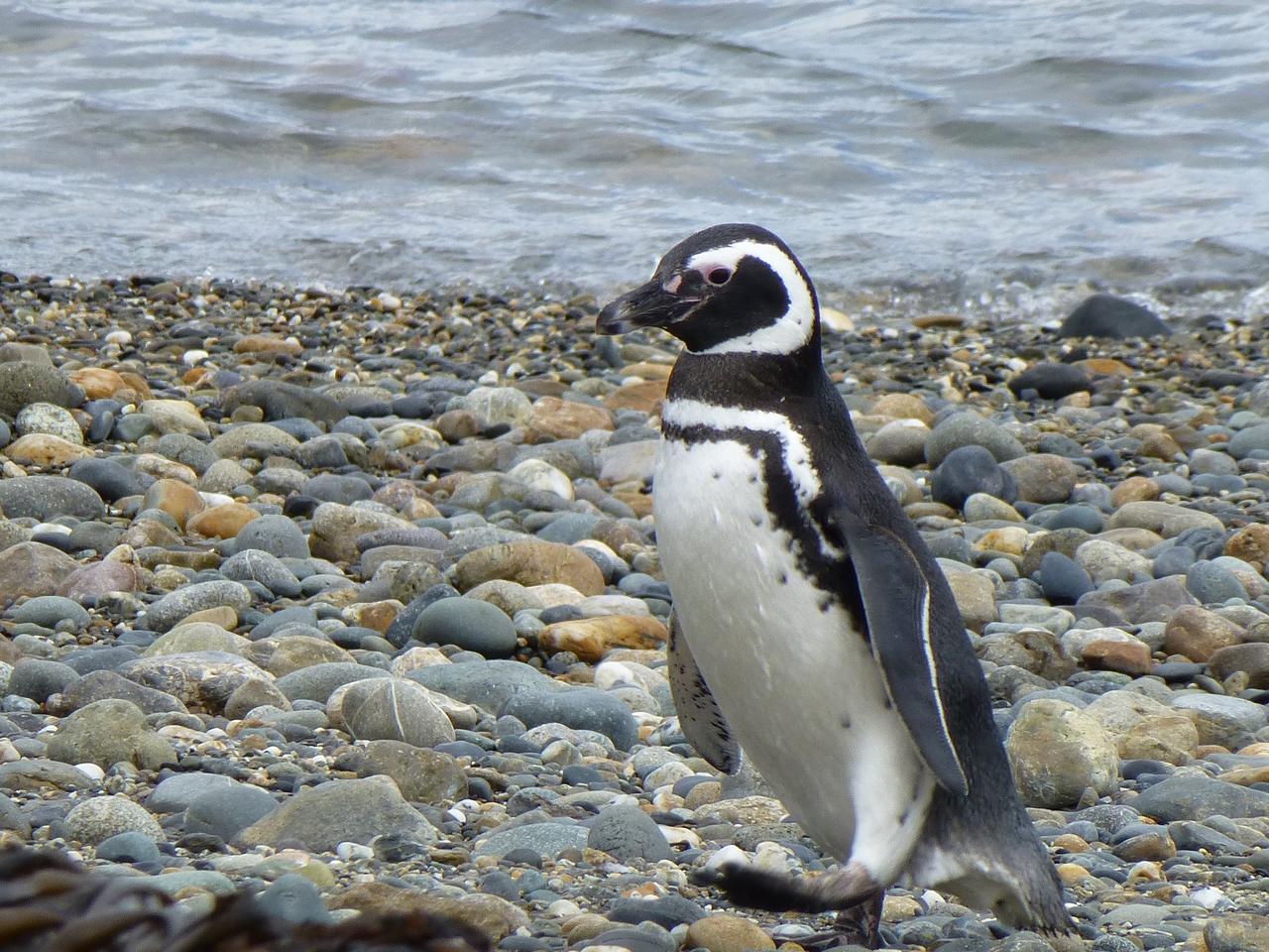
A penguin near Punta Arena, Chile, photographed in its natural summer habitat during NASA's AirSAR 2004 campaign. AirSAR 2004 is a three-week expedition in Central and South America by an international team of scientists that is using an all-weather imaging tool, called the Airborne Synthetic Aperture Radar (AirSAR), located onboard NASA's DC-8 airborne laboratory. Scientists from many parts of the world are combining ground research with NASA's AirSAR technology to improve and expand on the quality of research they are able to conduct.
JPL scientist Dr. David Imel and U.S. Air Force Colonel Gwen Linde, the Defense Department Attache Officer assigned to the Chilean Embassy, lead Chilean students on a tour of the DC-8 aircraft at Carlos Ibanez del Campo International Airport in Punta Arenas, Chile. AirSAR 2004 is a three-week expedition by an international team of scientists that is using an all-weather imaging tool, called the Airborne Synthetic Aperture Radar (AirSAR) which is located onboard NASA's DC-8 airborne laboratory. Scientists from many parts of the world including NASA's Jet Propulsion Laboratory are combining ground research done in several areas in Central and South America with NASA's AirSAR technology to improve and expand on the quality of research they are able to conduct. In South America and Antarctica, AirSAR will collect imagery and data to help determine the contribution of Southern Hemisphere glaciers to sea level rise due to climate change. In Patagonia, researchers found this contribution had more than doubled from 1995 to 2000, compared to the previous 25 years. AirSAR data will make it possible to determine whether that trend is decreasing, continuing or accelerating. AirSAR will also provide reliable information on ice shelf thickness to measure the contribution of the glaciers to sea level.
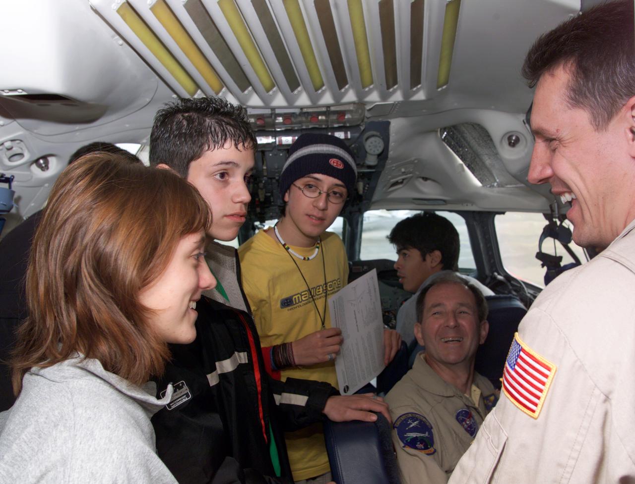
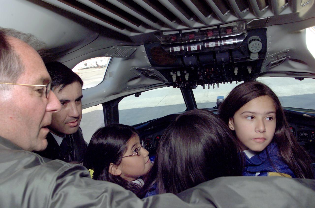
NASA DC-8 Pilots Craig Bomben and Bill Brockett explain the DC-8 cockpit to Chilean students onboard the DC-8 aircraft at Carlos Ibanez del Campo International Airport in Punta Arenas, Chile. AirSAR 2004 is a three-week expedition by an international team of scientists that is using an all-weather imaging tool, called the Airborne Synthetic Aperture Radar (AirSAR) which is located onboard NASA's DC-8 airborne laboratory. Scientists from many parts of the world including NASA's Jet Propulsion Laboratory are combining ground research done in several areas in Central and South America with NASA's AirSAR technology to improve and expand on the quality of research they are able to conduct. In South America and Antarctica, AirSAR will collect imagery and data to help determine the contribution of Southern Hemisphere glaciers to sea level rise due to climate change. In Patagonia, researchers found this contribution had more than doubled from 1995 to 2000, compared to the previous 25 years. AirSAR data will make it possible to determine whether that trend is decreasing, continuing or accelerating. AirSAR will also provide reliable information on ice shelf thickness to measure the contribution of the glaciers to sea level.
NASA’s DC-8 aircraft prior to launch from Carlos Ibanez International Airport in Punta Arenas, Chile, during AirSAR 2004. AirSAR 2004 is a three-week expedition in Central and South America by an international team of scientists that is using an all-weather imaging tool, called the Airborne Synthetic Aperture Radar (AirSAR), located onboard NASA's DC-8 airborne laboratory. Scientists from many parts of the world are combining ground research with NASA's AirSAR technology to improve and expand on the quality of research they are able to conduct.
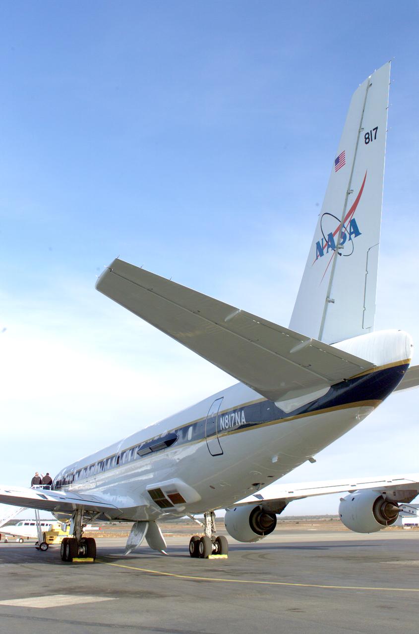
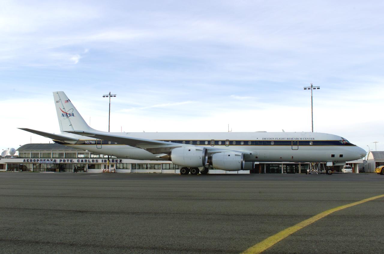
NASA’s DC-8 aircraft at Carlos Ibanez International Airport in Punta Arenas, Chile. A portion of AirSAR hardware is visible on the left rear fuselage. AirSAR 2004 is a three-week expedition in Central and South America by an international team of scientists that is using an all-weather imaging tool, called the Airborne Synthetic Aperture Radar (AirSAR), located onboard NASA's DC-8 airborne laboratory. Scientists from many parts of the world are combining ground research with NASA's AirSAR technology to improve and expand on the quality of research they are able to conduct.
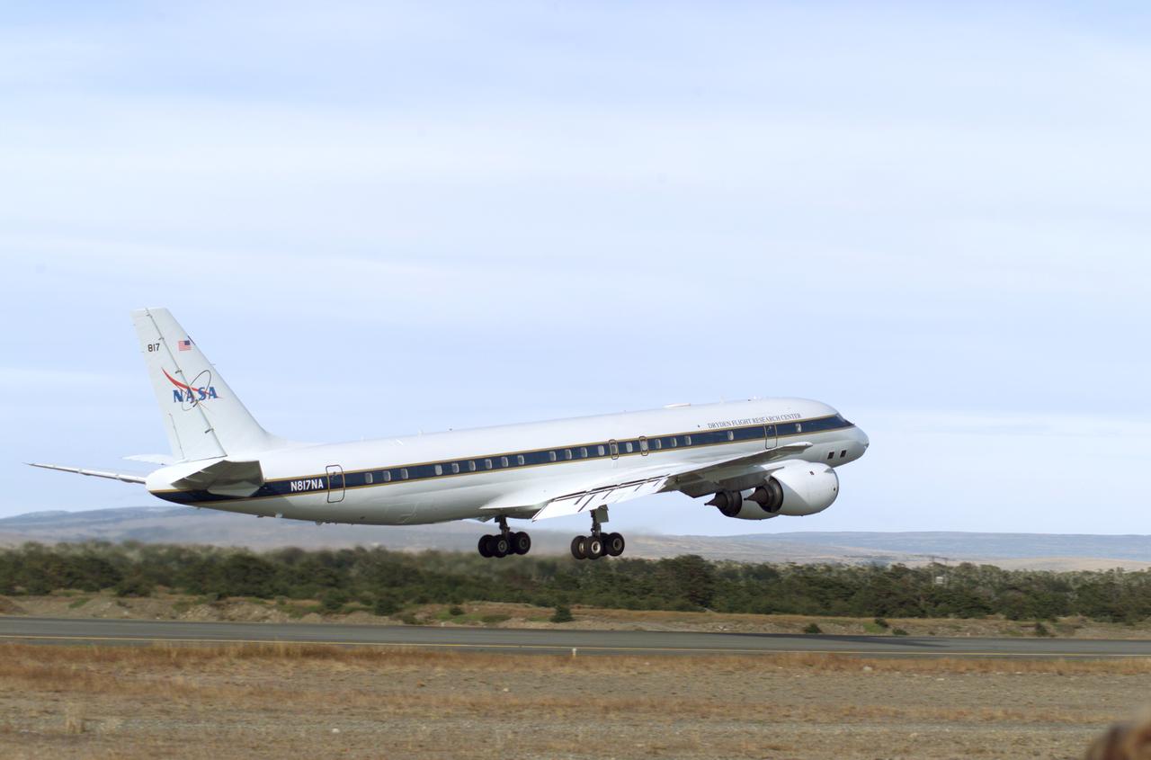
NASA's DC-8 flying laboratory takes off from Carlos Ibanez International Airport in Punta Arenas, Chile, during NASA's AirSAR 2004 campaign. AirSAR 2004 is a three-week expedition in Central and South America by an international team of scientists that is using an all-weather imaging tool, called the Airborne Synthetic Aperture Radar (AirSAR), located onboard NASA's DC-8 airborne laboratory. Scientists from many parts of the world are combining ground research with NASA's AirSAR technology to improve and expand on the quality of research they are able to conduct.
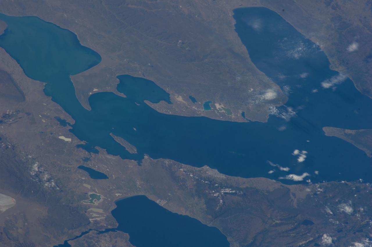
Earth observation taken by the Expedition 39 crew aboard the ISS. Image was released by astronaut on Twitter and downlinked in folder: Punta Arenas, (Cape Horn area), Chile.
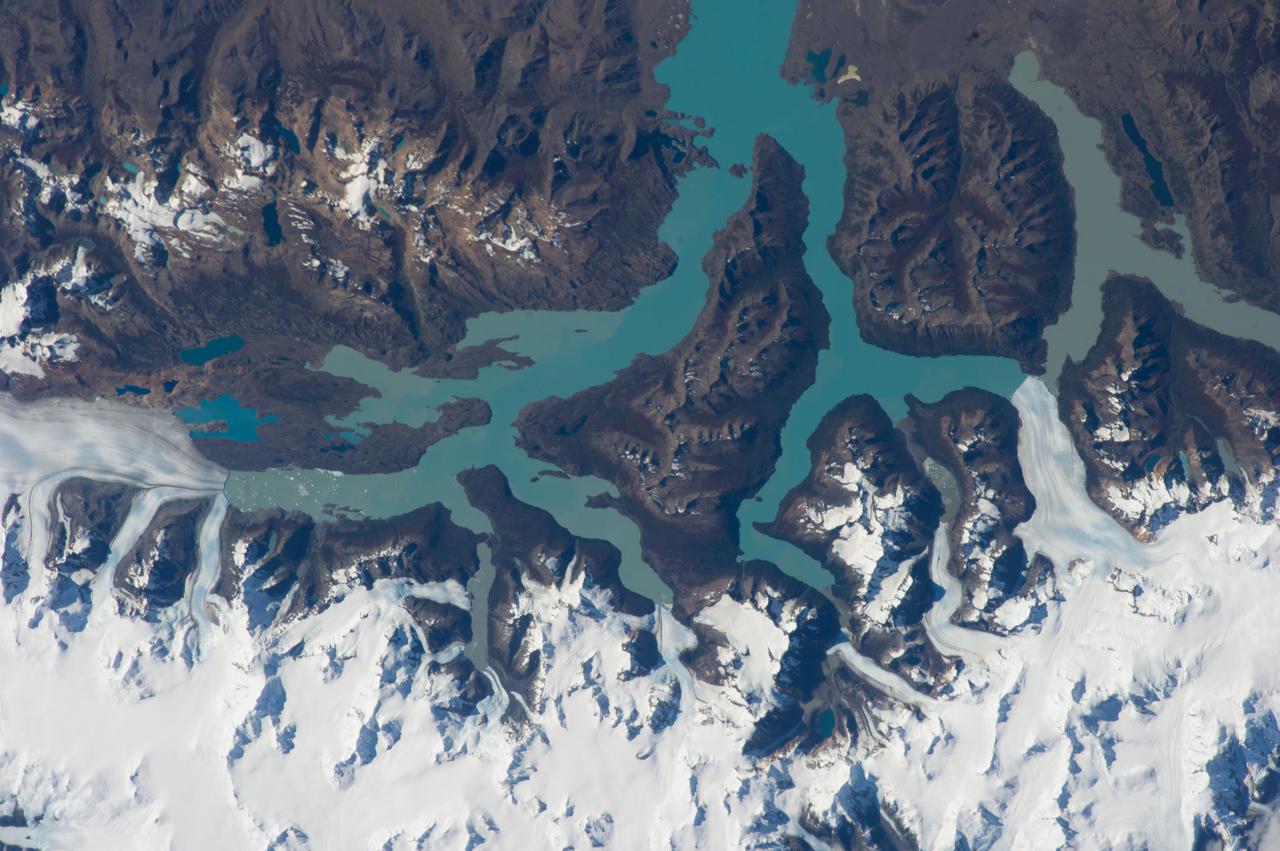
Earth observation taken by the Expedition 39 crew aboard the ISS. Image was released by astronaut on Twitter and downlinked in folder: Punta Arenas, (Cape Horn area), Chile.

NASA’s Operation IceBridge collected some rare images on a flight out of Punta Arenas, Chile on Nov. 5, 2014, on a science flight over western Antarctica dubbed Ferrigno-Alison-Abbott 01. Following a routine calibration pass over Punta Arenas airport, the NASA DC-8 overflew the USS Constellation which is being towed for demolition after 53 yeas of service. The crew then snapped a few shots of a calving front of the Antarctic ice sheet. This particular flight plan was designed to collect data on changes in ice elevation along the coast near the Ferrigno and Alison ice streams, on the Abbot Ice Shelf, and grounded ice along the Eights Coast.

The Thurston Island calving front off of western Antarctica as seen from the window of NASA's DC-8 on Nov. 5, 2014. Image Credit: NASA/Jim Yungel NASA’s Operation IceBridge collected some rare images on a flight out of Punta Arenas, Chile on Nov. 5, 2014, on a science flight over western Antarctica dubbed Ferrigno-Alison-Abbott 01. The crew snapped a few shots of a calving front of the Antarctic ice sheet. This particular flight plan was designed to collect data on changes in ice elevation along the coast near the Ferrigno and Alison ice streams, on the Abbot Ice Shelf, and grounded ice along the Eights Coast.

A sea of icebergs float near the Thurston Island calving front off of western Antarctica as seen on the IceBridge flight on Nov. 5, 2014. Image Credit: NASA/Jim Yungel NASA’s Operation IceBridge collected some rare images on a flight out of Punta Arenas, Chile on Nov. 5, 2014, on a science flight over western Antarctica dubbed Ferrigno-Alison-Abbott 01. The crew snapped a few shots of a calving front of the Antarctic ice sheet. This particular flight plan was designed to collect data on changes in ice elevation along the coast near the Ferrigno and Alison ice streams, on the Abbot Ice Shelf, and grounded ice along the Eights Coast.

A small hole in the clouds revealed newly formed sea ice in the Bellingshausen Sea next to an ice berg on Nov. 5, 2014 flight. Image Credit: NASA/Digital Mapping System NASA’s Operation IceBridge collected some rare images on a flight out of Punta Arenas, Chile on Nov. 5, 2014, on a science flight over western Antarctica dubbed Ferrigno-Alison-Abbott 01. The crew snapped a few shots of a calving front of the Antarctic ice sheet. This particular flight plan was designed to collect data on changes in ice elevation along the coast near the Ferrigno and Alison ice streams, on the Abbot Ice Shelf, and grounded ice along the Eights Coast.

Snow is blown off of the Thurston Island calving front off of western Antarctica as seen on the IceBridge flight on Nov. 5, 2014. Image Credit: NASA/Jim Yungel NASA’s Operation IceBridge collected some rare images on a flight out of Punta Arenas, Chile on Nov. 5, 2014, on a science flight over western Antarctica dubbed Ferrigno-Alison-Abbott 01. The crew snapped a few shots of a calving front of the Antarctic ice sheet. This particular flight plan was designed to collect data on changes in ice elevation along the coast near the Ferrigno and Alison ice streams, on the Abbot Ice Shelf, and grounded ice along the Eights Coast.

Mountain peaks through the ice cover on Thurston Island off of western Antarctica as seen on the IceBridge flight on Nov. 5, 2014. Image Credit: NASA/Jim Yungel NASA’s Operation IceBridge collected some rare images on a flight out of Punta Arenas, Chile on Nov. 5, 2014, on a science flight over western Antarctica dubbed Ferrigno-Alison-Abbott 01. The crew snapped a few shots of a calving front of the Antarctic ice sheet. This particular flight plan was designed to collect data on changes in ice elevation along the coast near the Ferrigno and Alison ice streams, on the Abbot Ice Shelf, and grounded ice along the Eights Coast.
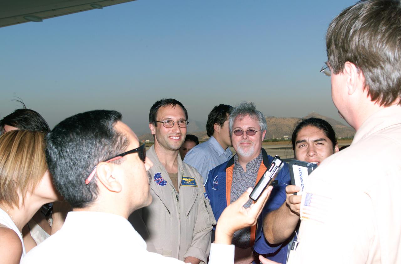
L to R; NASA Dryden Mission Manager Walter Klein (in tan flight suit), JPL AirSAR Scientist Tim Miller, and Mission Manager David Bushman briefing press in Santiago, Chile, for NASA's AirSAR 2004 mission. AirSAR 2004 is a three-week expedition by an international team of scientists that uses an all-weather imaging tool, called the Airborne Synthetic Aperture Radar (AirSAR) which is located onboard NASA's DC-8 airborne laboratory. Scientists from many parts of the world including NASA's Jet Propulsion Laboratory are combining ground research done in several areas in Central and South America with NASA's AirSAR technology to improve and expand on the quality of research they are able to conduct. In South America and Antarctica, AirSAR collected imagery and data to help determine the contribution of Southern Hemisphere glaciers to sea level rise due to climate change. In Patagonia, researchers found this contribution had more than doubled from 1995 to 2000, compared to the previous 25 years. AirSAR data will make it possible to determine whether that trend is continuing or accelerating. AirSAR will also provide reliable information on ice shelf thickness to measure the contribution of the glaciers to sea level.
Pilot Bill Brockett (left) and Chilean Air Force Captain Saez with school children in the cockpit of NASA Dryden's DC-8 flying laboratory. Brockett explained NASA's AirSAR 2004 mission in Chile. AirSAR 2004 is a three-week expedition by an international team of scientists that uses an all-weather imaging tool, called the Airborne Synthetic Aperture Radar (AirSAR) which is located onboard NASA's DC-8 airborne laboratory. Scientists from many parts of the world including NASA's Jet Propulsion Laboratory are combining ground research done in several areas in Central and South America with NASA's AirSAR technology to improve and expand on the quality of research they are able to conduct. In South America and Antarctica, AirSAR collected imagery and data to help determine the contribution of Southern Hemisphere glaciers to sea level rise due to climate change. In Patagonia, researchers found this contribution had more than doubled from 1995 to 2000, compared to the previous 25 years. AirSAR data will make it possible to determine whether that trend is continuing or accelerating. AirSAR will also provide reliable information on ice shelf thickness to measure the contribution of the glaciers to sea level.
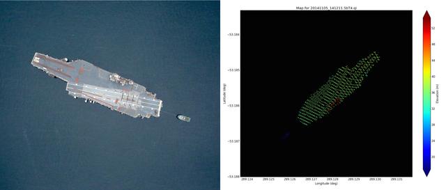
Left: NASA Digital Mapping System image of the USS Constellation taken near Punta Arenas, Chile on Nov. 5, 2014. Credit: NASA/DMS Right: Airborne Topographic Mapper wide scan lidar elevation data taken over the USS Constellation during Nov. 5, 2014 overflight. The water elevation has been removed and was 17 meters. The Constellation flight deck is about 16m above the water surface and the conning tower is about 33m above the water. Credit: NASA/ATM Read more: <a href="http://www.nasa.gov/content/goddard/icebridge/news/fall14/uss-constellation-and-thurston-island-nov-5/#.VGOy4khvL2g" rel="nofollow">www.nasa.gov/content/goddard/icebridge/news/fall14/uss-co...</a>
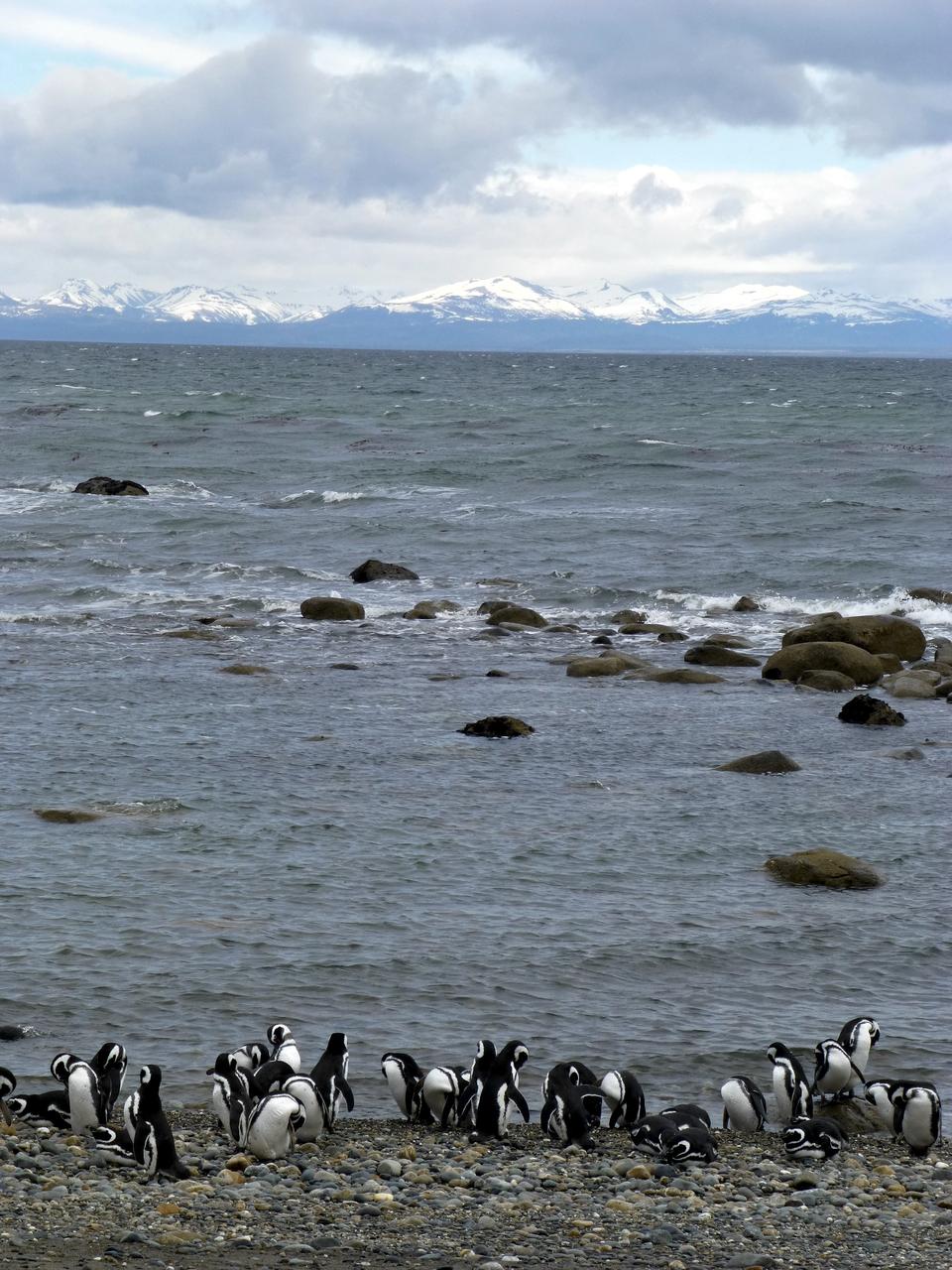
Members of the IceBridge team visited a colony of Magellanic penguins near Punta Arenas on a no-flight day. Credit: NASA/ Maria-Jose Vinas NASA's Operation IceBridge is an airborne science mission to study Earth's polar ice. For more information about IceBridge, visit: <a href="http://www.nasa.gov/icebridge" rel="nofollow">www.nasa.gov/icebridge</a> <b><a href="http://www.nasa.gov/audience/formedia/features/MP_Photo_Guidelines.html" rel="nofollow">NASA image use policy.</a></b> <b><a href="http://www.nasa.gov/centers/goddard/home/index.html" rel="nofollow">NASA Goddard Space Flight Center</a></b> enables NASA’s mission through four scientific endeavors: Earth Science, Heliophysics, Solar System Exploration, and Astrophysics. Goddard plays a leading role in NASA’s accomplishments by contributing compelling scientific knowledge to advance the Agency’s mission. <b>Follow us on <a href="http://twitter.com/NASA_GoddardPix" rel="nofollow">Twitter</a></b> <b>Like us on <a href="http://www.facebook.com/pages/Greenbelt-MD/NASA-Goddard/395013845897?ref=tsd" rel="nofollow">Facebook</a></b> <b>Find us on <a href="http://instagrid.me/nasagoddard/?vm=grid" rel="nofollow">Instagram</a></b>
Members of the IceBridge team visited a colony of Magellanic penguins near Punta Arenas on a no-flight day. Credit: NASA/ Maria-Jose Vinas NASA's Operation IceBridge is an airborne science mission to study Earth's polar ice. For more information about IceBridge, visit: <a href="http://www.nasa.gov/icebridge" rel="nofollow">www.nasa.gov/icebridge</a> <b><a href="http://www.nasa.gov/audience/formedia/features/MP_Photo_Guidelines.html" rel="nofollow">NASA image use policy.</a></b> <b><a href="http://www.nasa.gov/centers/goddard/home/index.html" rel="nofollow">NASA Goddard Space Flight Center</a></b> enables NASA’s mission through four scientific endeavors: Earth Science, Heliophysics, Solar System Exploration, and Astrophysics. Goddard plays a leading role in NASA’s accomplishments by contributing compelling scientific knowledge to advance the Agency’s mission. <b>Follow us on <a href="http://twitter.com/NASA_GoddardPix" rel="nofollow">Twitter</a></b> <b>Like us on <a href="http://www.facebook.com/pages/Greenbelt-MD/NASA-Goddard/395013845897?ref=tsd" rel="nofollow">Facebook</a></b> <b>Find us on <a href="http://instagrid.me/nasagoddard/?vm=grid" rel="nofollow">Instagram</a></b>
During a flight over the Pine Island Glacier ice shelf, the DC-8 banks over the Amundsen Sea and the clean edge of the ice shelf front. The shelf drops about 200 feet from its surface to sea level. This image was taken on Oct. 26, 2011. Credit: NASA/GSFC/Jefferson Beck NASA's Operation IceBridge returns to a base camp of Punta Arenas, Chile for the third year of flights over Antarctica's changing sea ice, glaciers and ice sheets. NASA's DC-8, outfitted with seven remote-sensing instruments, and a Gulfstream 5 operated by the National Science Foundation and National Center for Atmospheric Research and outfitted with a high-altitude laser-ranging mapper, will fly from Chile over Antarctica in October and November. The mission is designed to record changes to Antarctica's ice sheets and give scientists insight into what is driving those changes. Follow the progress of the mission: Campaign News site: <a href="http://www.nasa.gov/mission_pages/icebridge/index.html" rel="nofollow">www.nasa.gov/mission_pages/icebridge/index.html</a> IceBridge blog: <a href="http://blogs.nasa.gov/cm/newui/blog/viewpostlist.jsp?blogname=icebridge" rel="nofollow">blogs.nasa.gov/cm/newui/blog/viewpostlist.jsp?blogname=ic...</a> Twitter: @nasa_ice <b><a href="http://www.nasa.gov/audience/formedia/features/MP_Photo_Guidelines.html" rel="nofollow">NASA image use policy.</a></b> <b><a href="http://www.nasa.gov/centers/goddard/home/index.html" rel="nofollow">NASA Goddard Space Flight Center</a></b> enables NASA’s mission through four scientific endeavors: Earth Science, Heliophysics, Solar System Exploration, and Astrophysics. Goddard plays a leading role in NASA’s accomplishments by contributing compelling scientific knowledge to advance the Agency’s mission. <b>Follow us on <a href="http://twitter.com/NASA_GoddardPix" rel="nofollow">Twitter</a></b> <b>Like us on <a href="http://www.facebook.com/pages/Greenbelt-MD/NASA-Goddard/395013845897?ref=tsd" rel="nofollow">Facebook</a></b> <b>Find us on <a href="http://instagrid.me/nasagoddard/?vm=grid" rel="nofollow">Instagram</a></b>
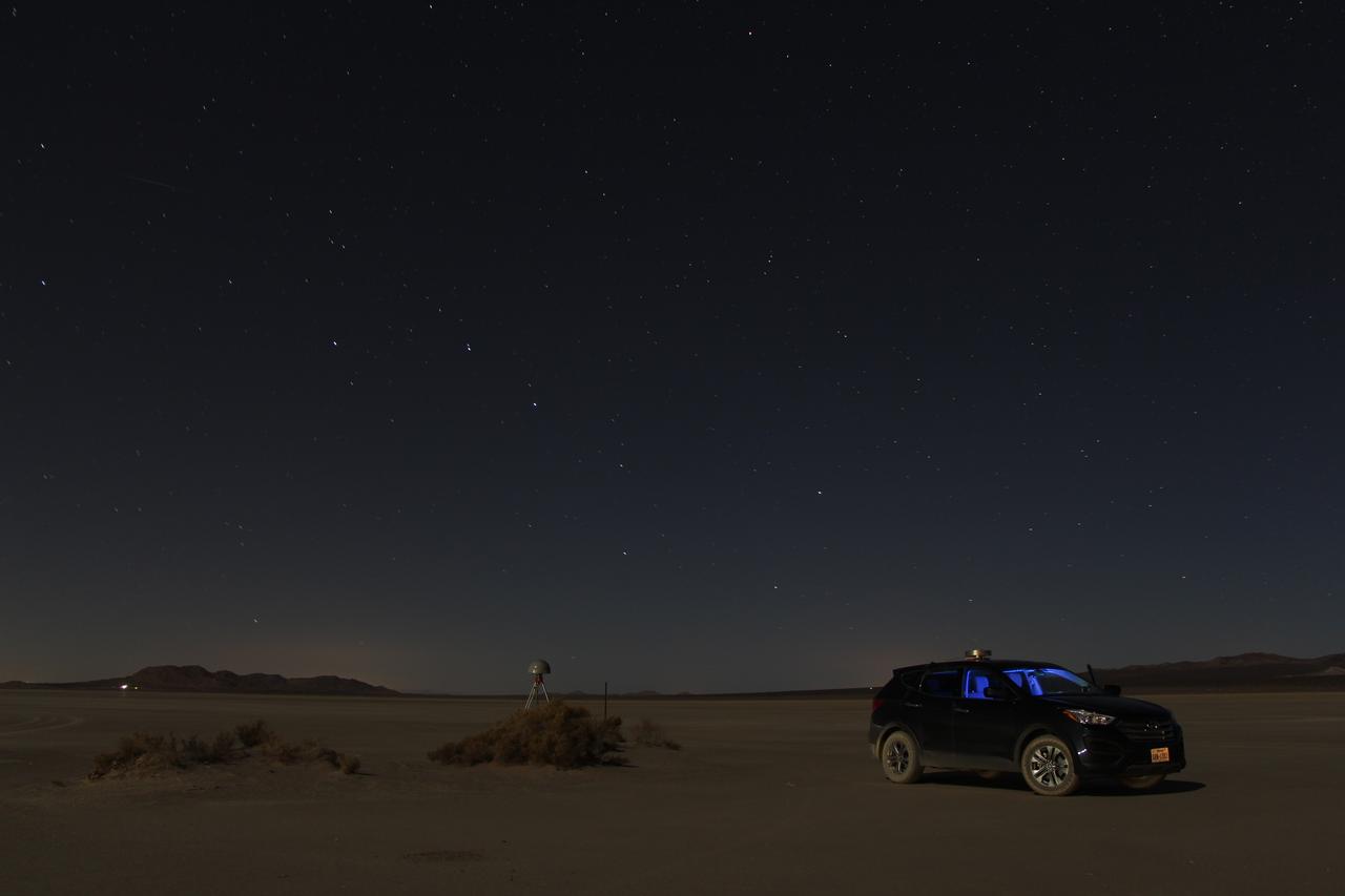
At first glance a dry lake bed in the southern California desert seems like the last place to prepare to study ice. But on Oct. 2, 2014, NASA’s Operation IceBridge carried out a ground-based GPS survey of the El Mirage lake bed in California’s Mojave Desert. Members of the IceBridge team are currently at NASA’s Armstrong Flight Research Center, preparing instruments aboard the DC-8 research aircraft for flights over Antarctica. Part of this preparation involves test flights over the desert, where researchers verify their instruments are working properly. El Mirage serves as a prime location for testing the mission’s laser altimeter, the Airborne Topographic Mapper, because the lake bed has a flat surface and reflects light similarly to snow and ice. This photo, taken shortly after the survey, shows the GPS-equipped survey vehicle and a stationary GPS station (left of the vehicle) on the lake bed with the constellation Ursa Major in the background. By driving the vehicle in parallel back and forth lines over a predefined area and comparing those GPS elevation readings with measurements from the stationary GPS, researchers are able to build an elevation map that will be used to precisely calibrate the laser altimeter for ice measurements. Credit: NASA/John Sonntag Operation IceBridge is scheduled to begin research flights over Antarctica on Oct. 15, 2014. The mission will be based out of Punta Arenas, Chile, until Nov. 23. For more information about IceBridge, visit: <a href="http://www.nasa.gov/icebridge" rel="nofollow">www.nasa.gov/icebridge</a> <b><a href="http://www.nasa.gov/audience/formedia/features/MP_Photo_Guidelines.html" rel="nofollow">NASA image use policy.</a></b> <b><a href="http://www.nasa.gov/centers/goddard/home/index.html" rel="nofollow">NASA Goddard Space Flight Center</a></b> enables NASA’s mission through four scientific endeavors: Earth Science, Heliophysics, Solar System Exploration, and Astrophysics. Goddard plays a leading role in NASA’s accomplishments by contributing compelling scientific knowledge to advance the Agency’s mission. <b>Follow us on <a href="http://twitter.com/NASAGoddardPix" rel="nofollow">Twitter</a></b> <b>Like us on <a href="http://www.facebook.com/pages/Greenbelt-MD/NASA-Goddard/395013845897?ref=tsd" rel="nofollow">Facebook</a></b> <b>Find us on <a href="http://instagram.com/nasagoddard?vm=grid" rel="nofollow">Instagram</a></b>
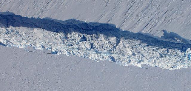
A close-up image of the crack spreading across the ice shelf of Pine Island Glacier shows the details of the boulder-like blocks of ice that fell into the rift when it split. For most of the 18-mile stretch of the crack that NASA’s DC-8 flew over on Oct. 26, 2011, it stretched about 240 feet wide, as roughly seen here. The deepest points ranged from about 165 to 190 feet, roughly equal to the top of the ice shelf down to sea level. Scientists expect the crack to propagate and the ice shelf to calve an iceberg of more than 300 square miles in the coming months. This image was captured by the Digital Mapping System (DMS) aboard the DC-8. Credit: NASA/DMS NASA's Operation IceBridge returns to a base camp of Punta Arenas, Chile for the third year of flights over Antarctica's changing sea ice, glaciers and ice sheets. NASA's DC-8, outfitted with seven remote-sensing instruments, and a Gulfstream 5 operated by the National Science Foundation and National Center for Atmospheric Research and outfitted with a high-altitude laser-ranging mapper, will fly from Chile over Antarctica in October and November. The mission is designed to record changes to Antarctica's ice sheets and give scientists insight into what is driving those changes. Follow the progress of the mission: Campaign News site: <a href="http://www.nasa.gov/mission_pages/icebridge/index.html" rel="nofollow">www.nasa.gov/mission_pages/icebridge/index.html</a> IceBridge blog: <a href="http://blogs.nasa.gov/cm/newui/blog/viewpostlist.jsp?blogname=icebridge" rel="nofollow">blogs.nasa.gov/cm/newui/blog/viewpostlist.jsp?blogname=ic...</a> Twitter: @nasa_ice <b><a href="http://www.nasa.gov/audience/formedia/features/MP_Photo_Guidelines.html" rel="nofollow">NASA image use policy.</a></b> <b><a href="http://www.nasa.gov/centers/goddard/home/index.html" rel="nofollow">NASA Goddard Space Flight Center</a></b> enables NASA’s mission through four scientific endeavors: Earth Science, Heliophysics, Solar System Exploration, and Astrophysics. Goddard plays a leading role in NASA’s accomplishments by contributing compelling scientific knowledge to advance the Agency’s mission. <b>Follow us on <a href="http://twitter.com/NASA_GoddardPix" rel="nofollow">Twitter</a></b> <b>Like us on <a href="http://www.facebook.com/pages/Greenbelt-MD/NASA-Goddard/395013845897?ref=tsd" rel="nofollow">Facebook</a></b> <b>Find us on <a href="http://instagrid.me/nasagoddard/?vm=grid" rel="nofollow">Instagram</a></b>