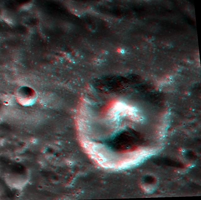
A Puzzling Crack
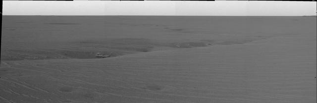
A Puzzling Peak
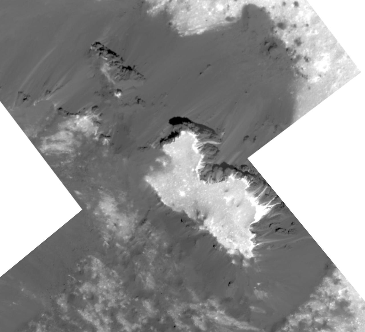
Pebble Puzzle Solved

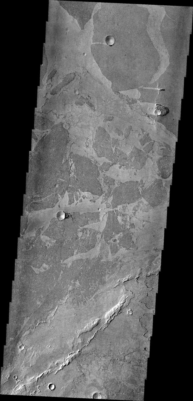
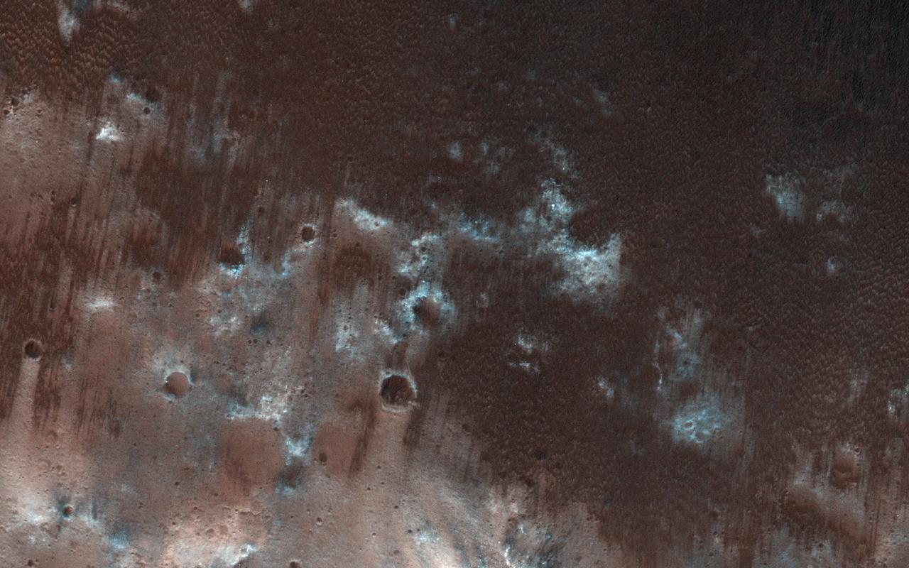
This image shows large, relatively flat-lying, puzzle-like pieces in this scene are mesas composed largely of solid carbon dioxide

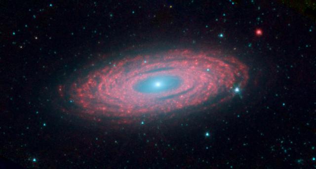
The beautiful spiral galaxy visible in the center of the image is known as RX J1140.1+0307, a galaxy in the Virgo constellation imaged by the NASA/ESA Hubble Space Telescope, and it presents an interesting puzzle. At first glance, this galaxy appears to be a normal spiral galaxy, much like the Milky Way, but first appearances can be deceptive! The Milky Way galaxy, like most large galaxies, has a supermassive black hole at its center, but some galaxies are centered on lighter, intermediate-mass black holes. RX J1140.1+0307 is such a galaxy — in fact, it is centered on one of the lowest black hole masses known in any luminous galactic core. What puzzles scientists about this particular galaxy is that the calculations don’t add up. With such a relatively low mass for the central black hole, models for the emission from the object cannot explain the observed spectrum. There must be other mechanisms at play in the interactions between the inner and outer parts of the accretion disk surrounding the black hole. Credit: ESA/Hubble & NASA, Acknowledgement: Judy Schmidt <b><a href="http://www.nasa.gov/audience/formedia/features/MP_Photo_Guidelines.html" rel="nofollow">NASA image use policy.</a></b> <b><a href="http://www.nasa.gov/centers/goddard/home/index.html" rel="nofollow">NASA Goddard Space Flight Center</a></b> enables NASA’s mission through four scientific endeavors: Earth Science, Heliophysics, Solar System Exploration, and Astrophysics. Goddard plays a leading role in NASA’s accomplishments by contributing compelling scientific knowledge to advance the Agency’s mission. <b>Follow us on <a href="http://twitter.com/NASAGoddardPix" rel="nofollow">Twitter</a></b> <b>Like us on <a href="http://www.facebook.com/pages/Greenbelt-MD/NASA-Goddard/395013845897?ref=tsd" rel="nofollow">Facebook</a></b> <b>Find us on <a href="http://instagrid.me/nasagoddard/?vm=grid" rel="nofollow">Instagram</a></b>
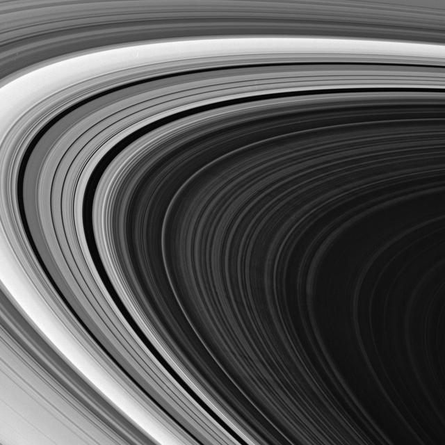
The Cassini spacecraft spies multiple spokes in Saturn outer B ring. The precise origin and evolution of these transient features continue to provide ring scientists with intriguing puzzles to solve
Platy lava flows in Elysium look very different from the thicker flows of the Tharsis region. In this image from NASA 2001 Mars Odyssey spacecraft, the darker plates are separated by lighter material and some edges match-up like puzzle pieces.

The primary mirror of NASA's James Webb Space Telescope consisting of 18 hexagonal mirrors looks like a giant puzzle piece standing in the massive clean room of NASA's Goddard Space Flight Center in Greenbelt, Maryland. Appropriately, combined with the rest of the observatory, the mirrors will help piece together puzzles scientists have been trying to solve throughout the cosmos. Webb's primary mirror will collect light for the observatory in the scientific quest to better understand our solar system and beyond. Using these mirrors and Webb's infrared vision scientists will peer back over 13.5 billion years to see the first stars and galaxies forming out of the darkness of the early universe. Unprecedented infrared sensitivity will help astronomers to compare the faintest, earliest galaxies to today's grand spirals and ellipticals, helping us to understand how galaxies assemble over billions of years. Webb will see behind cosmic dust clouds to see where stars and planetary systems are being born. It will also help reveal information about atmospheres of planets outside our solar system, and perhaps even find signs of the building blocks of life elsewhere in the universe. The Webb telescope was mounted upright after a "center of curvature" test conducted at Goddard. This initial center of curvature test ensures the integrity and accuracy, and test will be repeated later to verify those same properties after the structure undergoes launch environment testing. In the photo, two technicians stand before the giant primary mirror. For information on the Webb's Center of Curvature test, visit: <a href="http://go.nasa.gov/2fidD9S" rel="nofollow">go.nasa.gov/2fidD9S</a> Credit: NASA/Goddard/Chris Gunn <b><a href="http://www.nasa.gov/audience/formedia/features/MP_Photo_Guidelines.html" rel="nofollow">NASA image use policy.</a></b> <b><a href="http://www.nasa.gov/centers/goddard/home/index.html" rel="nofollow">NASA Goddard Space Flight Center</a></b> enables NASA’s mission through four scientific endeavors: Earth Science, Heliophysics, Solar System Exploration, and Astrophysics. Goddard plays a leading role in NASA’s accomplishments by contributing compelling scientific knowledge to advance the Agency’s mission. <b>Follow us on <a href="http://twitter.com/NASAGoddardPix" rel="nofollow">Twitter</a></b> <b>Like us on <a href="http://www.facebook.com/pages/Greenbelt-MD/NASA-Goddard/395013845897?ref=tsd" rel="nofollow">Facebook</a></b> <b>Find us on <a href="http://instagrid.me/nasagoddard/?vm=grid" rel="nofollow">Instagram</a></b>
This image was taken by the Long Range Reconnaissance Imager (LORRI) on NASA's New Horizons spacecraft shortly before closest approach to Pluto on July 14, 2015; it resolves details as small as 270 yards (250 meters). The scene shown is about 130 miles (210 kilometers) across. The sun illuminates the scene from the left, and north is to the upper left. Credits: NASA/JHUAPL/SwRI It seems that the more we see of Pluto, the more fascinating it gets. With its prominent heart-shaped feature, icy mountains, and “snakeskin” terrain, Pluto has already surprised New Horizons scientists with the variety and complexity of its surface features. Now this latest image, from the heart of Pluto’s heart feature, show the plains’ enigmatic cellular pattern (at left) as well as unusual clusters of small pits and troughs (from lower left to upper right). Scientists believe that this area, informally known as Sputnik Planum, is composed of volatile ices such as solid nitrogen. They theorize that the pits and troughs – typically hundreds of meters across and tens of meters deep – are possibly formed by sublimation or evaporation of these ices. However, the reasons for the striking shapes and alignments of these features are a mystery. Adding to the intrigue is that even at this resolution, no impact craters are seen, testifying to the extreme geologic youth of Sputnik Planum. “Pluto is weird, in a good way,” said Hal Weaver, New Horizons project scientist with Johns Hopkins Applied Physics Laboratory in Laurel, Maryland. “The pits, and the way they’re aligned, provide clues about the ice flow and the exchange of volatiles between the surface and atmosphere, and the science team is working hard to understand what physical processes are at play here.” <b><a href="http://www.nasa.gov/audience/formedia/features/MP_Photo_Guidelines.html" rel="nofollow">NASA image use policy.</a></b> <b><a href="http://www.nasa.gov/centers/goddard/home/index.html" rel="nofollow">NASA Goddard Space Flight Center</a></b> enables NASA’s mission through four scientific endeavors: Earth Science, Heliophysics, Solar System Exploration, and Astrophysics. Goddard plays a leading role in NASA’s accomplishments by contributing compelling scientific knowledge to advance the Agency’s mission. <b>Follow us on <a href="http://twitter.com/NASAGoddardPix" rel="nofollow">Twitter</a></b> <b>Like us on <a href="http://www.facebook.com/pages/Greenbelt-MD/NASA-Goddard/395013845897?ref=tsd" rel="nofollow">Facebook</a></b> <b>Find us on <a href="http://instagrid.me/nasagoddard/?vm=grid" rel="nofollow">Instagram</a></b>
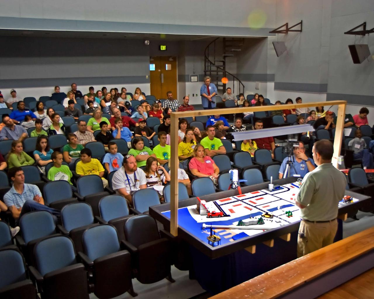
Randall Hicks (right), Jacobs Technology's Education Services manager at NASA John C. Stennis Space Center, answers questions about the playing field for FIRST (For Inspiration and Recognition of Science and Technology) LEGO League's 2007 Challenge, `Power Puzzle.' More than 140 teachers, mentors, parents and students from 15 schools attended the Sept. 15 FLL season kickoff at StenniSphere, the visitor center at SSC. The teams from southern and central Mississippi and Mobile, Ala., who came to SSC heard rules for and asked questions about `Power Puzzle,' and saw robot demonstrations by Gulfport and Picayune high schools' past FIRST Robotics competitions. Using LEGO Mindstorms NXT kits, FLL teams of children ages 9-14 will spend the next three months building and programming robots to perform 'Power Puzzle's' challenge tasks, then pit them in competitions. They also will submit a research project about how energy choices impact the environment and the economy. The season will culminate at the Mississippi Championship Tournament on Dec. 8 at the Mississippi Gulf Coast Community College. FLL, considered the `little league' of the FIRST Robotics Competition, partners FIRST and the LEGO Group. Competitions aim to inspire and celebrate science and technology using real-world context and hands-on experimentation. NASA recognizes FIRST activities as an excellent hands-on method to increase student knowledge of science, engineering, technology and mathematics. Schools represented in this year's kickoff were: Madison Avenue Upper Elementary, the Mississippi Band of Choctaw Indians' Conehatta Elementary, Hattiesburg's Lillie Burney Elementary, Pearl Upper Elementary, Long Beach Middle, Oktibehha Elementary, d'Iberville Middle, Saucier's West Wortham Middle, Picayune's Nicholson Elementary and Roseland Park Baptist Church Academy, Bay St. Louis' St. Stanislaus College and Mobile's Davidson High, as well as two home-school groups from the Jackson area.
An age-defying star designated as IRAS 19312+1950 exhibits features characteristic of a very young star and a very old star. The object stands out as extremely bright inside a large, chemically rich cloud of material, as shown in this image from NASA’s Spitzer Space Telescope. A NASA-led team of scientists thinks the star – which is about 10 times as massive as our sun and emits about 20,000 times as much energy – is a newly forming protostar. That was a big surprise because the region had not been known as a stellar nursery before. But the presence of a nearby interstellar bubble, which indicates the presence of a recently formed massive star, also supports this idea. Read more: <a href="http://go.nasa.gov/2bMza9d" rel="nofollow">go.nasa.gov/2bMza9d</a> Image Credit: NASA/JPL-Caltech

Visitors put a puzzle together at a NASA exhibit at the Apollo 11 50th Anniversary celebration on the National Mall, Thursday, July 18, 2019 in Washington. Apollo 11 was the first mission to land astronauts on the Moon and launched on July 16, 1969 with astronauts Neil Armstrong, Michael Collins, and Buzz Aldrin. Photo Credit: (NASA/Aubrey Gemignani)
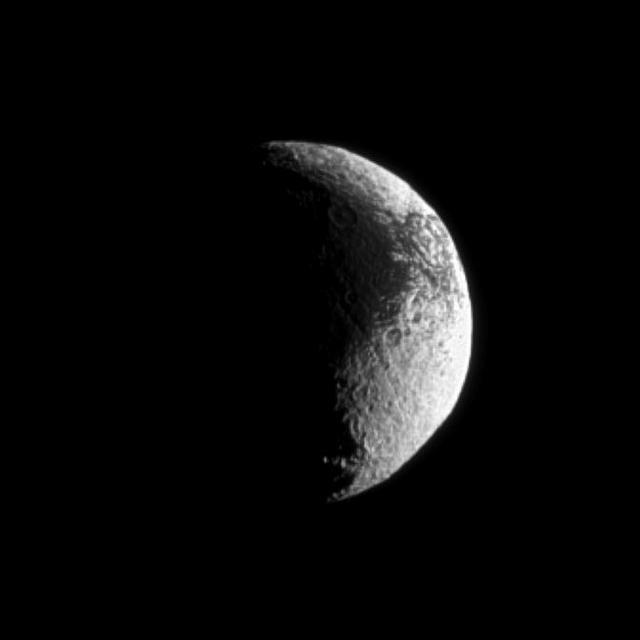
Iapetus shows off its puzzling light and dark terrain in this image captured by NASA Cassini spacecraft. Lit terrain seen here is on the Saturn-facing side of Iapetus.
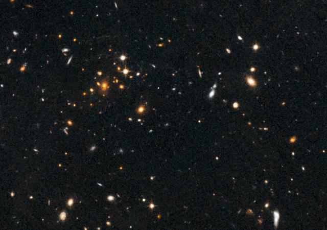
Astronomers using NASA Hubble Space Telescope have found a puzzling arc of light behind an extremely massive cluster of galaxies residing 10 billion light-years away.
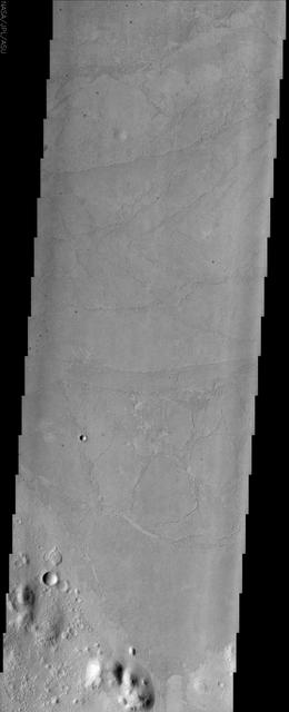
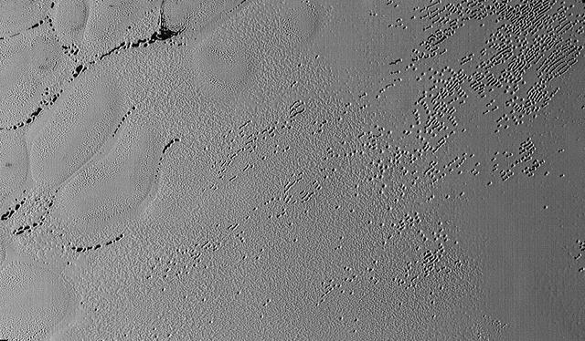
The lowland plains of Elysium Planitia contains a terrain that puzzles Mars scientists. Landforms in the region are the plates and ridges seen throughout most of this image from NASA Mars Odyssey.
Some might see a pancake, and others a sand dollar, in this new image from NASA Dawn mission. Astronomers are puzzling over a mysterious large circular feature located south of the equator and slightly to the right of center in this view.
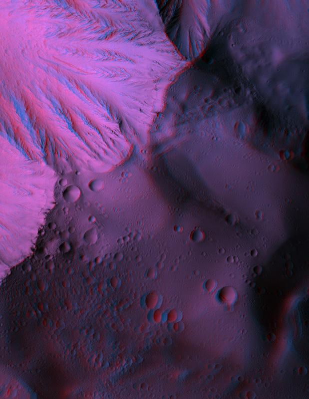
This anaglyph from NASA Mars Reconnaissance Orbiter spacecraft, shows Olympus Mons, the largest volcano in the Solar System. Constructed of lava flows, many aspects of this titanic volcano remain puzzling. 3D glasses are necessary to view this image.
This image from NASA Cassini, made possible only as Saturn north pole emerged from winter darkness, shows new details of a jet stream that follows a hexagon-shaped path and has long puzzled scientists.

A participant at a NASA-sponsored Earth Day event puts together a puzzle of the Earth, Monday, April 22, 2013 at Union Station in Washington. (Photo Credit: NASA/Carla Cioffi)
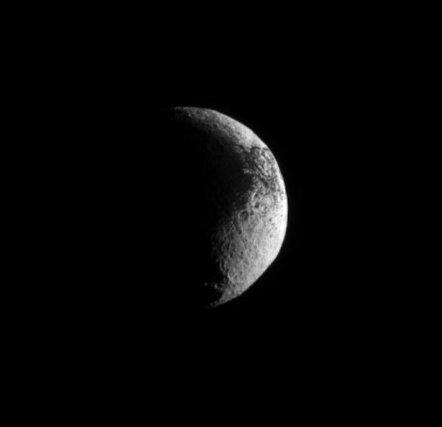
NASA Cassini spacecraft examines the rough dark-light dichotomy of the terrain on Saturn moon Iapetus. Lit terrain seen here is on the Saturn-facing side of Iapetus.
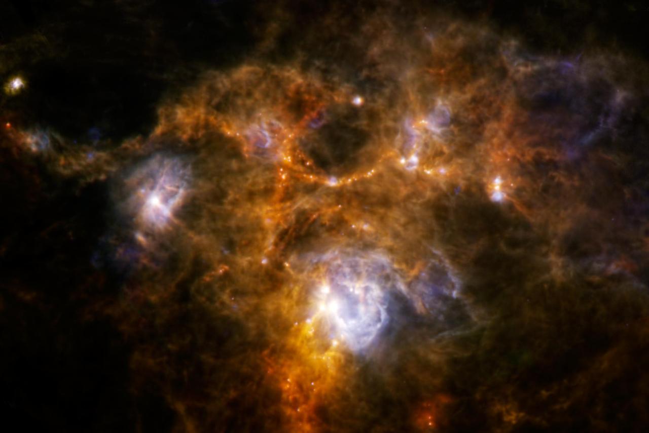
The Herschel Space Observatory has uncovered a weird ring of dusty material while obtaining one of the sharpest scans to date of a huge cloud of gas and dust, called NGC 7538.
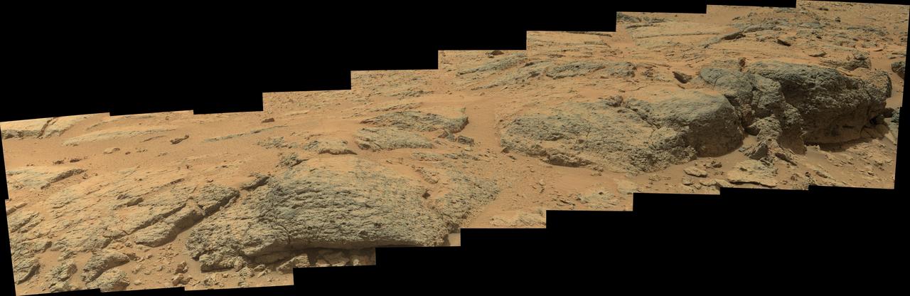
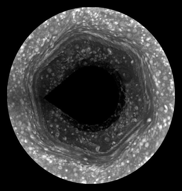
This mosaic view from the Mast Camera Mastcam on NASA Mars rover Curiosity shows textural characteristics and shapes of an outcrop called Point Lake. The outcrop is about 20 inches half a meter high and pockmarked with holes.

iss069e033719 (July 17, 2023) -- (From left) Culmer's Cay, Glass Cay, Tommy Young's Cay, Davy Cay, Hog Cay, and Green Turtle Cay—islands off the mainland Great Abaco in the Bahamas— appear like jigsaw puzzle pieces as the bright teals and blues of the Atlantic Ocean flow and swirl between the land. The International Space Station orbited 259 miles above as this photograph was taken.
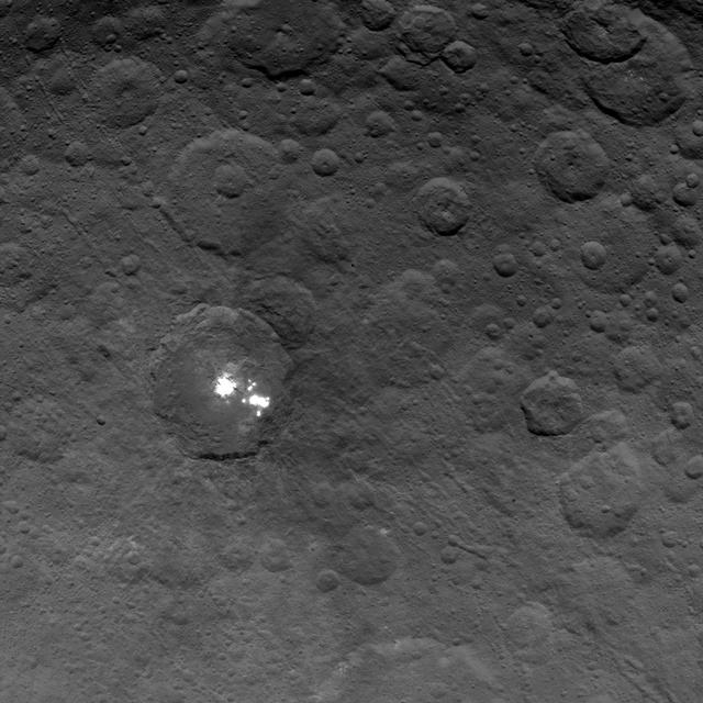
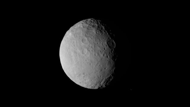
The brightest spots on dwarf planet Ceres are seen in this image taken by NASA's Dawn spacecraft on June 6, 2015. This is among the first snapshots from Dawn's second mapping orbit, which is 2,700 miles (4,400 kilometers) in altitude. The resolution is 1,400 feet (410 meters) per pixel. Scientists are still puzzled by the nature of these spots, and are considering explanations that include salt and ice. http://photojournal.jpl.nasa.gov/catalog/PIA19568
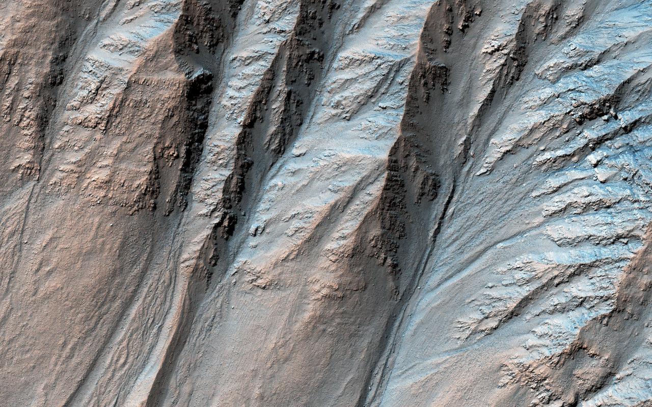
Most gullies in the southern mid-latitudes are on south-facing slopes, which are the coldest and have the most frost in the winter. However, some occur on other slopes. This image shows large gullies on both the pole- and equator-facing slopes. An important puzzle in Mars science is whether or not all of these gullies form in the same geologic eras and by the same processes. If you have red/green glasses, be sure to check out the anaglyph of this crater, which shows rugged topography! https://photojournal.jpl.nasa.gov/catalog/PIA23100
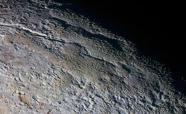
In this extended color image of Pluto taken by NASA New Horizons spacecraft, rounded and bizarrely textured mountains, informally named the Tartarus Dorsa, rise up along Pluto's day-night terminator and show intricate but puzzling patterns of blue-gray ridges and reddish material in between. This view, roughly 330 miles (530 kilometers) across, combines blue, red and infrared images taken by the Ralph/Multispectral Visual Imaging Camera (MVIC) on July 14, 2015, and resolves details and colors on scales as small as 0.8 miles (1.3 kilometers). http://photojournal.jpl.nasa.gov/catalog/PIA19957
This mosaic of a prominent mound located on the western side of Cerealia Facula was obtained by NASA's Dawn spacecraft on June 22, 2018 from an altitude of about 21 miles (34 kilometers). The geometry of this feature is similar to a mesa or large butte with a flat top. It has been puzzling scientists since its discovery in the early images of the Dawn mission at Ceres. These new images reveal many details. In particular, the relationships between the bright material, mostly composed of sodium carbonate, and the dark background might hold clues about the origin of the facula. This feature is located at about 19.5 degrees north latitude and 239.2 degrees east longitude. https://photojournal.jpl.nasa.gov/catalog/PIA22477
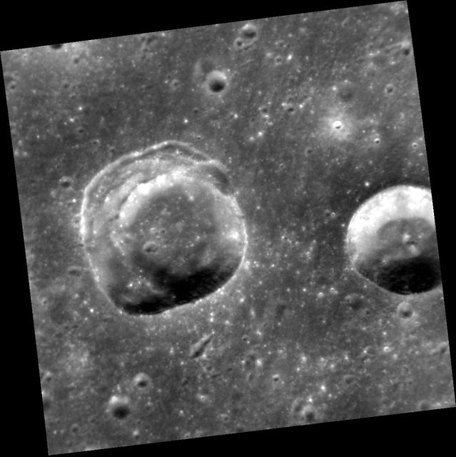
This view shows two craters in an area of smooth plains. The crater on the left presents an interesting geological puzzle. Note that about 90° of the rim (in the east, the right side) is sharp. But the remaining 270° of the circumference consists of a broad terrace, formed by slumping and inward movement of material. Why do you think that part of the rim and wall suffered slumping? Differences in the strength of the target material? (And, if so, caused by what?) The angle at which the impactor struck the surface? The topography of the surface? The presence of buried topography or structures? Local or regional tectonics? What additional data could help to solve this riddle? http://photojournal.jpl.nasa.gov/catalog/PIA19232
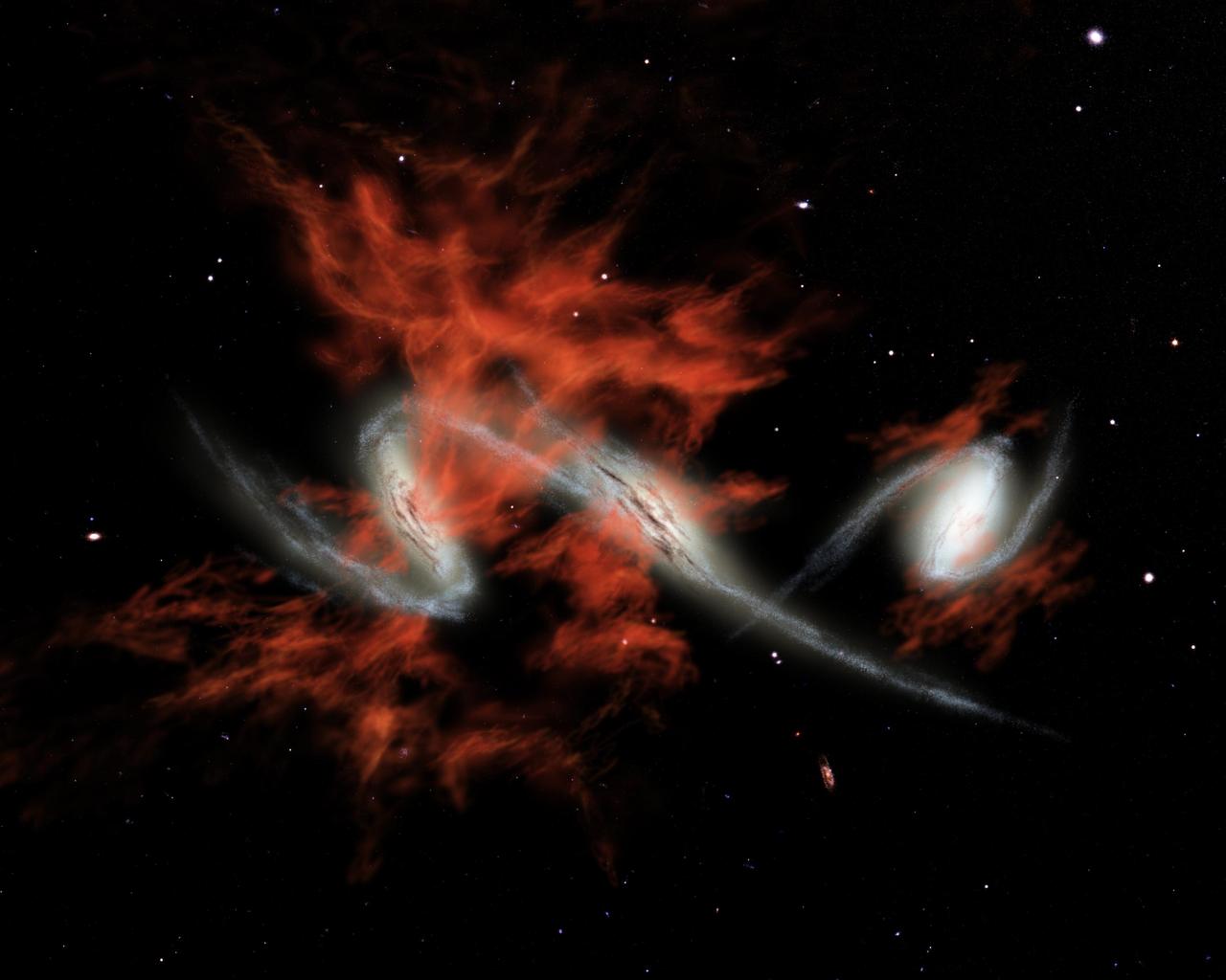
This artist's concept illustrates one possible answer to the puzzle of the "giant galactic blobs." These blobs (red), first identified about five years ago, are mammoth clouds of intensely glowing material that surround distant galaxies (white). Astronomers using visible-light telescopes can see the glow of the blobs, but they didn't know what provides the energy to light them up. NASA's Spitzer Space Telescope set its infrared eyes on one well-known blob located 11 billion light-years away, and discovered three tremendously bright galaxies, each shining with the light of more than one trillion Suns, headed toward each other. Spitzer also observed three other blobs in the same galactic neighborhood and found equally bright galaxies within them. One of these blobs is also known to contain galaxies merging together. The findings suggest that galactic mergers might be the mysterious source of blobs. If so, then one explanation for how mergers produce such large clouds of material is that they trigger intense bursts of star formation. This star formation would lead to exploding massive stars, or supernovae, which would then shoot gases outward in a phenomenon known as superwinds. Blobs produced in this fashion are illustrated in this artist's concept. http://photojournal.jpl.nasa.gov/catalog/PIA07221

Neptune's blue-green atmosphere is shown in greater detail than ever before by the Voyager 2 spacecraft as it rapidly approaches its encounter with the giant planet. This color image, produced from a distance of about 16 million kilometers, shows several complex and puzzling atmospheric features. The Great Dark Spot (GDS) seen at the center is about 13,000 km by 6,600 km in size -- as large along its longer dimension as the Earth. The bright, wispy "cirrus-type" clouds seen hovering in the vicinity of the GDS are higher in altitude than the dark material of unknown origin which defines its boundaries. A thin veil often fills part of the GDS interior, as seen on the image. The bright cloud at the southern (lower) edge of the GDS measures about 1,000 km in its north-south extent. The small, bright cloud below the GDS, dubbed the "scooter," rotates faster than the GDS, gaining about 30 degrees eastward (toward the right) in longitude every rotation. Bright streaks of cloud at the latitude of the GDS, the small clouds overlying it, and a dimly visible dark protrusion at its western end are examples of dynamic weather patterns on Neptune, which can change significantly on time scales of one rotation (about 18 hours). https://photojournal.jpl.nasa.gov/catalog/PIA02245

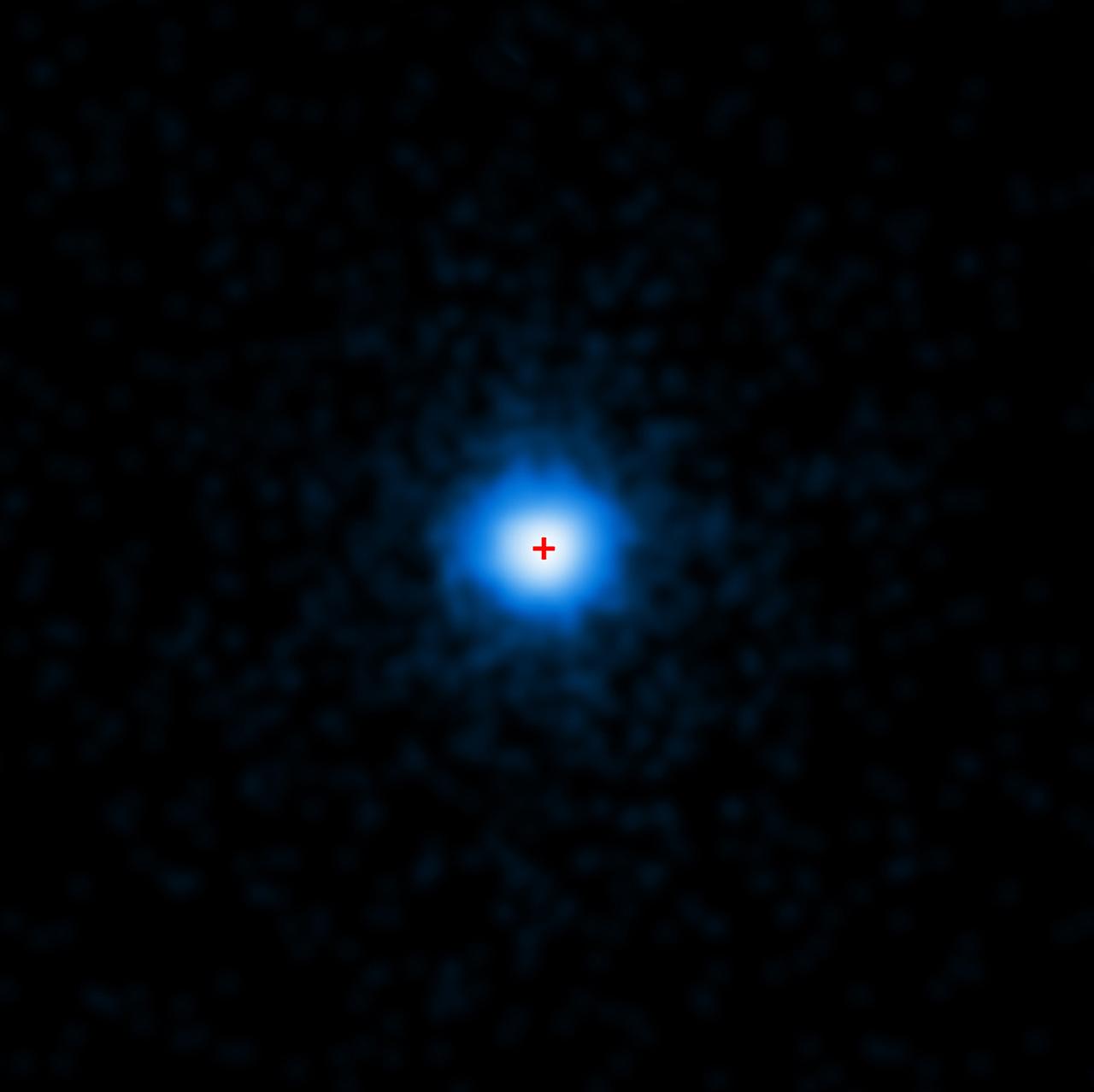
In this illustration, an asteroid (bottom left) breaks apart under the powerful gravity of LSPM J0207+3331, the oldest, coldest white dwarf known to be surrounded by a ring of dusty debris. Scientists think the system’s infrared signal is best explained by two distinct rings composed of dust supplied by crumbling asteroids. Credit: NASA’s Goddard Space Flight Center/Scott Wiessinger https://svs.gsfc.nasa.gov/13147
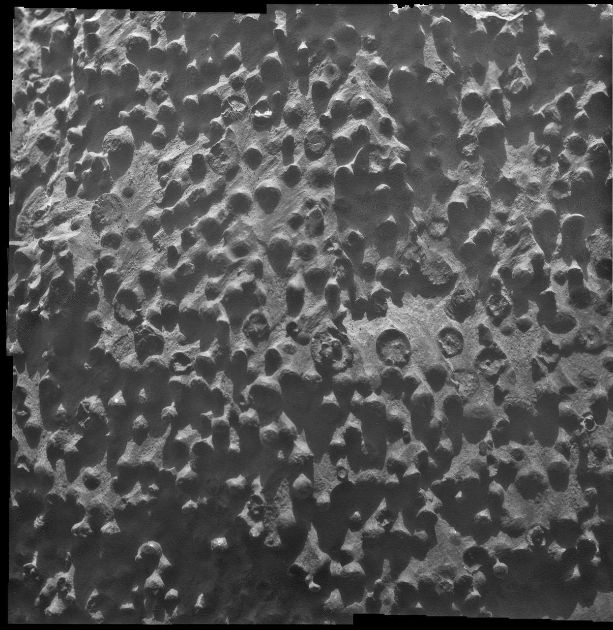
Small spherical objects fill the field in this mosaic combining four images from the Microscopic Imager on NASA Mars Exploration Rover Opportunity at an outcrop called Kirkwood in the Cape York segment of the western rim of Endeavour Crater.
This image from NASA's Spitzer Space Telescope shows the spiral galaxy NGC 2841, located about 46 million light-years from Earth in the constellation Ursa Major. The galaxy is helping astronomers solve one of the oldest puzzles in astronomy: Why do galaxies look so smooth, with stars sprinkled evenly throughout? An international team of astronomers has discovered that rivers of young stars flow from their hot, dense stellar nurseries, dispersing out to form large, smooth distributions. This image is a composite of three different wavelengths from Spitzer's infrared array camera. The shortest wavelengths are displayed inblue, and mostly show the older stars in NGC 2841, as well as foreground stars in our own Milky Way galaxy. The cooler areas are highlighted in red, and show the dusty, gaseous regions of the galaxy. Blue shows infrared light of 3.6 microns, green represents 4.5-micron light and red, 8.0-micron light. The contribution from starlight measured at 3.6 microns has been subtracted from the 8.0-micron data to enhance the visibility of the dust features.The shortest wavelengths are displayed inblue, and mostly show the older stars in NGC 2841, as well as foreground stars in our own Milky Way galaxy. http://photojournal.jpl.nasa.gov/catalog/PIA12001
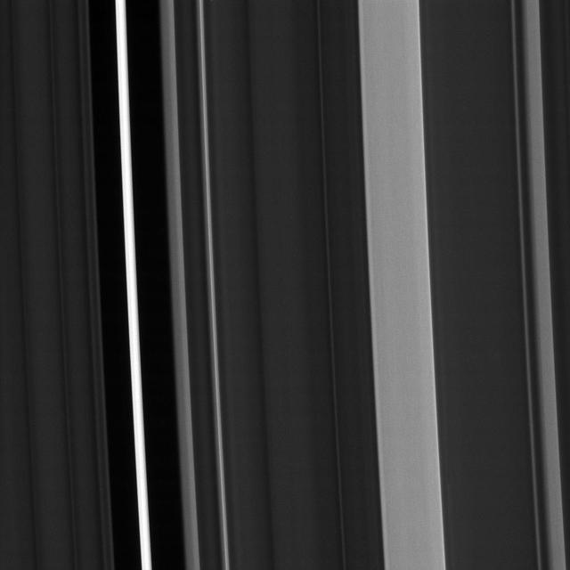
Saturn's C ring isn't uniformly bright. Instead, about a dozen regions of the ring stand out as noticeably brighter than the rest of the ring, while about half a dozen regions are devoid of ring material. Scientists call the bright regions "plateaus" and the devoid regions "gaps." Scientists have determined that the plateaus are relatively bright because they have higher particle density and reflect more light, but researchers haven't solved the trickier puzzle of how the plateaus are created and maintained. This view looks toward the sunlit side of the rings from about 62 degrees above the ring plane. The image was taken Jan. 9, 2017 in green light with the Cassini spacecraft's narrow-angle camera. Cassini obtained the image while approximately 194,000 miles (312,000 kilometers) from Saturn and at a Sun-Saturn-spacecraft, or phase, angle of 67 degrees. Image scale is 1.2 miles (2 kilometers) per pixel. https://photojournal.jpl.nasa.gov/catalog/PIA20529

This un-named crater in southwestern Arabia Terra contains a treasure! Layered sediments are the key to the puzzle of Martian history. They tell us about the conditions that existed when the sediments were deposited, and how they changed over time. This image shows an eroded mesa made up of rhythmically layered bedrock that seems to indicate cyclic deposition. The layers are accentuated by recent dark sand deposits that have accumulated on the benches of the brighter sediments. The plateau is topped by a younger set of layers that appear to be finer and less blocky than the older layers below, suggesting a different depositional environment. Similar layered sediments are found in nearby craters in southwestern Arabia Terra. This image was requested by a member of the public who is interested in these deposits and will study them further by making a digital elevation model and measuring the thickness of the layers. Everyone is welcome to suggest interesting targets for HiRISE observations! https://photojournal.jpl.nasa.gov/catalog/PIA24946
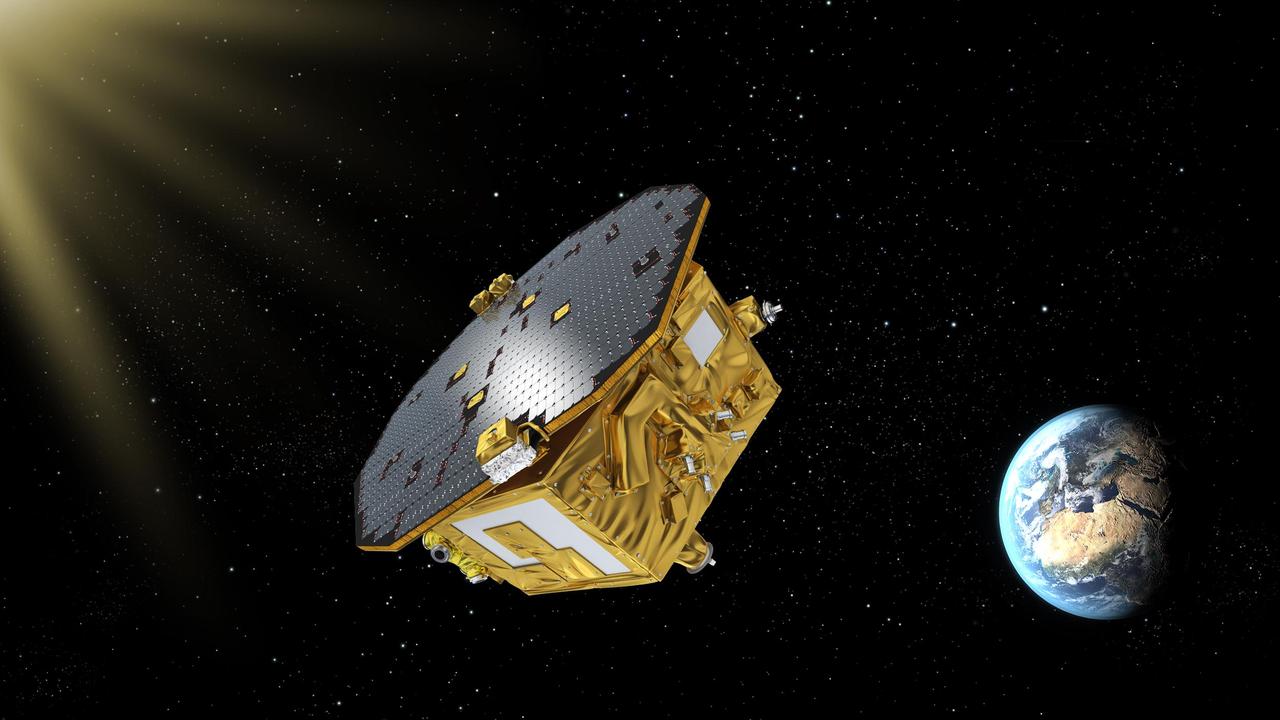
This artist's concept shows ESA's LISA Pathfinder spacecraft, which launched on Dec. 3, 2015, from Kourou, French Guiana, will help pave the way for a mission to detect gravitational waves. LISA Pathfinder, led by the European Space Agency (ESA), is designed to test technologies that could one day detect gravitational waves. Gravitational waves, predicted by Einstein's theory of general relativity, are ripples in spacetime produced by any accelerating body. But the waves are so weak that Earth- or space-based observatories would likely only be able to directly detect such signals coming from massive astronomical systems, such as binary black holes or exploding stars. Detecting gravitational waves would be an important piece in the puzzle of how our universe began. http://photojournal.jpl.nasa.gov/catalog/PIA20196

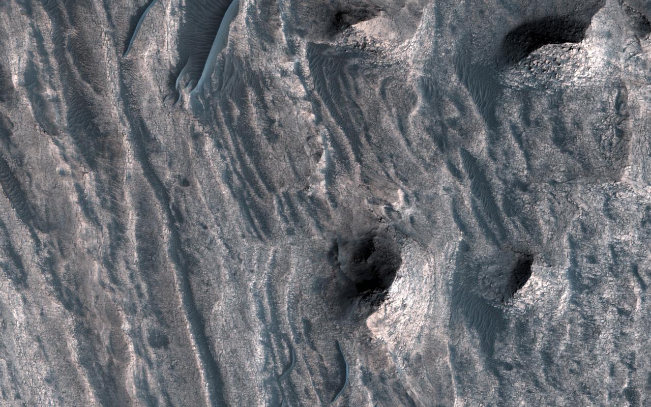
This complicated area contains various types of channels, pits and fractures. We can determine the relative ages of the pits and channels based on which features cross-cut others. Older channels appear smooth-edged and shallow. Younger channels and pits are deeper and more sharp-edged, as well as less sinuous than the shallower channels. What caused this array of various channels and intersecting pits? This region is covered in vast lava flows. The collapse pits here may be collapsed lava tubes or where overlying rock "drained" into voids created by extensional faulting. The older smoother channel that seems to source from this region may have carried an outflow of groundwater. It continues on for over 100 kilometers (62 miles). The orientation and shapes of these features make an interesting geological puzzle. http://photojournal.jpl.nasa.gov/catalog/PIA21066
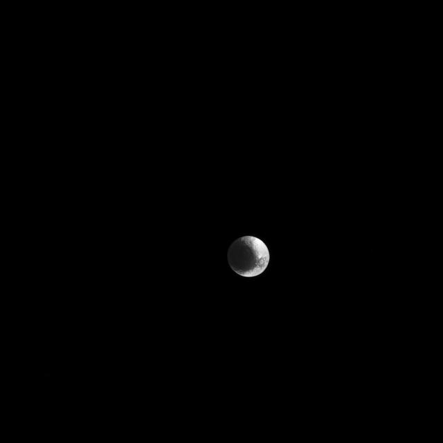
Iapetus is a world of contrast, with light and dark regions fitting together like cosmic puzzle pieces. Cassini Regio on Iapetus (914 miles or 1,471 kilometers across) is covered in a layer of dark, dusty material creating a stark contrast to the much brighter region that surrounds it. This leads to the moon's distinctive, two-toned appearance. This view looks toward Saturn-facing hemisphere of Iapetus. North on Iapetus is up and rotated 20 degrees to the right. The image was taken in visible light with the Cassini spacecraft narrow-angle camera on March 11, 2017. The view was obtained at a distance of approximately 1.6 million miles (2.6 million kilometers) from Iapetus. Image scale is 9 miles (15 kilometers) per pixel. https://photojournal.jpl.nasa.gov/catalog/PIA21332
![Color from the High Resolution Imaging Science Experiment (HiRISE) instrument onboard NASA's Mars Reconnaissance Orbiter can show mineralogical differences due to the near-infrared filter. The sources of channels on the north rim of Hale Crater show fresh blue, green, purple and light toned exposures under the the overlying reddish dust. The causes and timing of activity in channels and gullies on Mars remains an active area of research. Geologists infer the timing of different events based on what are called "superposition relationships" between different landforms. Areas like this are a puzzle. The map is projected here at a scale of 25 centimeters (9.8 inches) per pixel. [The original image scale is 25.2 centimeters (9.9 inches) per pixel (with 1 x 1 binning); objects on the order of 76 centimeters (29.9 inches) across are resolved.] North is up. https://photojournal.jpl.nasa.gov/catalog/PIA21586](https://images-assets.nasa.gov/image/PIA21586/PIA21586~medium.jpg)
Color from the High Resolution Imaging Science Experiment (HiRISE) instrument onboard NASA's Mars Reconnaissance Orbiter can show mineralogical differences due to the near-infrared filter. The sources of channels on the north rim of Hale Crater show fresh blue, green, purple and light toned exposures under the the overlying reddish dust. The causes and timing of activity in channels and gullies on Mars remains an active area of research. Geologists infer the timing of different events based on what are called "superposition relationships" between different landforms. Areas like this are a puzzle. The map is projected here at a scale of 25 centimeters (9.8 inches) per pixel. [The original image scale is 25.2 centimeters (9.9 inches) per pixel (with 1 x 1 binning); objects on the order of 76 centimeters (29.9 inches) across are resolved.] North is up. https://photojournal.jpl.nasa.gov/catalog/PIA21586
This view from NASA's Mars Reconnaissance Orbiter shows the downwind stretches of a sand sheet in central part of the much larger Herschel Crater. This sandy province began kilometers upwind in a string of barchan sand dunes. As the north-to-south blowing wind weakened downwind, it could no longer fashion the sand into dunes but rather into amorphously-shaped sand sheets. While perhaps not awe-inspiringly beautiful, sand sheets can tell us about Mars' current and past environmental conditions as a piece of the puzzle for understanding habitability. Having dunes upwind of sheets is the opposite situation Earth has, where upwind sand sheets evolve downwind into sand dunes. This mystery is receiving ongoing research to to understand these sandy differences between Earth and Mars. https://photojournal.jpl.nasa.gov/catalog/PIA21933
![The puzzling, fascinating surface of Jupiter icy moon Europa looms large in this newly-reprocessed [sic] color view, made from images taken by NASA Galileo spacecraft in the late 1990s. This is the color view of Europa from Galileo that shows the largest portion of the moon's surface at the highest resolution. The view was previously released as a mosaic with lower resolution and strongly enhanced color (see PIA02590). To create this new version, the images were assembled into a realistic color view of the surface that approximates how Europa would appear to the human eye. The scene shows the stunning diversity of Europa's surface geology. Long, linear cracks and ridges crisscross the surface, interrupted by regions of disrupted terrain where the surface ice crust has been broken up and re-frozen into new patterns. Color variations across the surface are associated with differences in geologic feature type and location. For example, areas that appear blue or white contain relatively pure water ice, while reddish and brownish areas include non-ice components in higher concentrations. The polar regions, visible at the left and right of this view, are noticeably bluer than the more equatorial latitudes, which look more white. This color variation is thought to be due to differences in ice grain size in the two locations. Images taken through near-infrared, green and violet filters have been combined to produce this view. The images have been corrected for light scattered outside of the image, to provide a color correction that is calibrated by wavelength. Gaps in the images have been filled with simulated color based on the color of nearby surface areas with similar terrain types. This global color view consists of images acquired by the Galileo Solid-State Imaging (SSI) experiment on the spacecraft's first and fourteenth orbits through the Jupiter system, in 1995 and 1998, respectively. Image scale is 1 mile (1.6 kilometers) per pixel. North on Europa is at right. http://photojournal.jpl.nasa.gov/catalog/PIA19048](https://images-assets.nasa.gov/image/PIA19048/PIA19048~medium.jpg)
The puzzling, fascinating surface of Jupiter icy moon Europa looms large in this newly-reprocessed [sic] color view, made from images taken by NASA Galileo spacecraft in the late 1990s. This is the color view of Europa from Galileo that shows the largest portion of the moon's surface at the highest resolution. The view was previously released as a mosaic with lower resolution and strongly enhanced color (see PIA02590). To create this new version, the images were assembled into a realistic color view of the surface that approximates how Europa would appear to the human eye. The scene shows the stunning diversity of Europa's surface geology. Long, linear cracks and ridges crisscross the surface, interrupted by regions of disrupted terrain where the surface ice crust has been broken up and re-frozen into new patterns. Color variations across the surface are associated with differences in geologic feature type and location. For example, areas that appear blue or white contain relatively pure water ice, while reddish and brownish areas include non-ice components in higher concentrations. The polar regions, visible at the left and right of this view, are noticeably bluer than the more equatorial latitudes, which look more white. This color variation is thought to be due to differences in ice grain size in the two locations. Images taken through near-infrared, green and violet filters have been combined to produce this view. The images have been corrected for light scattered outside of the image, to provide a color correction that is calibrated by wavelength. Gaps in the images have been filled with simulated color based on the color of nearby surface areas with similar terrain types. This global color view consists of images acquired by the Galileo Solid-State Imaging (SSI) experiment on the spacecraft's first and fourteenth orbits through the Jupiter system, in 1995 and 1998, respectively. Image scale is 1 mile (1.6 kilometers) per pixel. North on Europa is at right. http://photojournal.jpl.nasa.gov/catalog/PIA19048
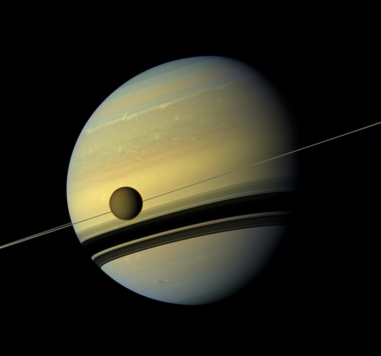
The puzzling appearance of an ice cloud seemingly out of thin air has prompted NASA scientists to suggest that a different process than previously thought -- possibly similar to one seen over Earth's poles -- could be forming clouds on Saturn's moon Titan. Located in Titan's stratosphere, the cloud is made of a compound of carbon and nitrogen known as dicyanoacetylene (C4N2), an ingredient in the chemical cocktail that colors the giant moon's hazy, brownish-orange atmosphere. Read more: <a href="http://go.nasa.gov/2crVEPM" rel="nofollow">go.nasa.gov/2crVEPM</a> <b><a href="http://www.nasa.gov/audience/formedia/features/MP_Photo_Guidelines.html" rel="nofollow">NASA image use policy.</a></b> <b><a href="http://www.nasa.gov/centers/goddard/home/index.html" rel="nofollow">NASA Goddard Space Flight Center</a></b> enables NASA’s mission through four scientific endeavors: Earth Science, Heliophysics, Solar System Exploration, and Astrophysics. Goddard plays a leading role in NASA’s accomplishments by contributing compelling scientific knowledge to advance the Agency’s mission. <b>Follow us on <a href="http://twitter.com/NASAGoddardPix" rel="nofollow">Twitter</a></b> <b>Like us on <a href="http://www.facebook.com/pages/Greenbelt-MD/NASA-Goddard/395013845897?ref=tsd" rel="nofollow">Facebook</a></b> <b>Find us on <a href="http://instagrid.me/nasagoddard/?vm=grid" rel="nofollow">Instagram</a></b>
NASA image releaes April 6, 2011 This is a visible-light image of GRB 110328A's host galaxy (arrow) taken on April 4 by the Hubble Space Telescope's Wide Field Camera 3. The galaxy is 3.8 billion light-years away. Credit: NASA/ESA/A. Fruchter (STScI) NASA's Swift, Hubble Space Telescope and Chandra X-ray Observatory have teamed up to study one of the most puzzling cosmic blasts yet observed. More than a week later, high-energy radiation continues to brighten and fade from its location. Astronomers say they have never seen anything this bright, long-lasting and variable before. Usually, gamma-ray bursts mark the destruction of a massive star, but flaring emission from these events never lasts more than a few hours. Although research is ongoing, astronomers say that the unusual blast likely arose when a star wandered too close to its galaxy's central black hole. Intense tidal forces tore the star apart, and the infalling gas continues to stream toward the hole. According to this model, the spinning black hole formed an outflowing jet along its spin axis. A powerful blast of X- and gamma rays is seen if this jet is pointed in our direction. To read more go to: <a href="http://www.nasa.gov/topics/universe/features/star-disintegration.." rel="nofollow">www.nasa.gov/topics/universe/features/star-disintegration..</a>. NASA Goddard Space Flight Center enables NASA’s mission through four scientific endeavors: Earth Science, Heliophysics, Solar System Exploration, and Astrophysics. Goddard plays a leading role in NASA’s accomplishments by contributing compelling scientific knowledge to advance the Agency’s mission. Follow us on Twitter Join us on Facebook

This rendering shows the area where NASA's Curiosity Mars rover climbed a steep slope to reach a location called Gediz Vallis channel, which it began exploring for several months starting in February 2024. Imagery captured by the High-Resolution Imaging Experiment (HiRISE) camera on NASA's Mars Reconnaissance Orbiter, along with other instruments, were used to make the visualization. Since 2014, Curiosity has been ascending the foothills of Mount Sharp, which stands 3 miles (5 kilometers) above the floor of Gale Crater. The layers in this lower part of the mountain formed over millions of years under a changing Martian climate, providing scientists with a way to study how the presence of both water and the chemical ingredients required for life changed over time. This image covers part of a region on Mount Sharp enriched in sulfates, salty minerals that often form as water evaporates. At the bottom of the image is the slope Curiosity climbed to get here, which includes alternating dark and light bands of sedimentary material that scientists are still puzzling over. Above those bands is the roughly 300-foot-wide (91-meter-wide) Gediz Vallis channel. The formation's sides are filled with dark sand while its center is filled with mounds of boulders and other debris. Scientists aren't entirely sure how the channel was formed; it could have been carved into the surrounding bedrock by an ancient river or debris flows (rapid, wet landslides). The debris currently filling the channel could have been carried down the channel as debris flows or in dry avalanches. On the right side of the image, the mounds of debris form a large ridge that continues farther down Mount Sharp. The route in Figure A shows how Curiosity veered off to study the ridge up close. https://photojournal.jpl.nasa.gov/catalog/PIA26241

This photograph shows the Compton Gamma-Ray Observatory (GRO) being deployed by the Remote Manipulator System (RMS) arm aboard the Space Shuttle Atlantis during the STS-37 mission in April 1991. The GRO reentered Earth atmosphere and ended its successful mission in June 2000. For nearly 9 years, the GRO Burst and Transient Source Experiment (BATSE), designed and built by the Marshall Space Flight Center (MSFC), kept an unblinking watch on the universe to alert scientists to the invisible, mysterious gamma-ray bursts that had puzzled them for decades. By studying gamma-rays from objects like black holes, pulsars, quasars, neutron stars, and other exotic objects, scientists could discover clues to the birth, evolution, and death of stars, galaxies, and the universe. The gamma-ray instrument was one of four major science instruments aboard the Compton. It consisted of eight detectors, or modules, located at each corner of the rectangular satellite to simultaneously scan the entire universe for bursts of gamma-rays ranging in duration from fractions of a second to minutes. In January 1999, the instrument, via the Internet, cued a computer-controlled telescope at Las Alamos National Laboratory in Los Alamos, New Mexico, within 20 seconds of registering a burst. With this capability, the gamma-ray experiment came to serve as a gamma-ray burst alert for the Hubble Space Telescope, the Chandra X-Ray Observatory, and major gound-based observatories around the world. Thirty-seven universities, observatories, and NASA centers in 19 states, and 11 more institutions in Europe and Russia, participated in the BATSE science program.
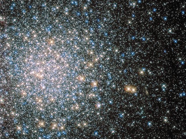
This sparkling jumble is Messier 5 — a globular cluster consisting of hundreds of thousands of stars bound together by their collective gravity. But Messier 5 is no normal globular cluster. At 13 billion years old it dates back to close to the beginning of the Universe, which is some 13.8 billion years of age. It is also one of the biggest clusters known, and at only 24 500 light-years away, it is no wonder that Messier 5 is a popular site for astronomers to train their telescopes on. Messier 5 also presents a puzzle. Stars in globular clusters grow old and wise together. So Messier 5 should, by now, consist of old, low-mass red giants and other ancient stars. But it is actually teeming with young blue stars known as blue stragglers. These stars spring to life when stars collide, or rip material from one another. Credit: ESA/NASA <b><a href="http://www.nasa.gov/audience/formedia/features/MP_Photo_Guidelines.html" rel="nofollow">NASA image use policy.</a></b> <b><a href="http://www.nasa.gov/centers/goddard/home/index.html" rel="nofollow">NASA Goddard Space Flight Center</a></b> enables NASA’s mission through four scientific endeavors: Earth Science, Heliophysics, Solar System Exploration, and Astrophysics. Goddard plays a leading role in NASA’s accomplishments by contributing compelling scientific knowledge to advance the Agency’s mission. <b>Follow us on <a href="http://twitter.com/NASAGoddardPix" rel="nofollow">Twitter</a></b> <b>Like us on <a href="http://www.facebook.com/pages/Greenbelt-MD/NASA-Goddard/395013845897?ref=tsd" rel="nofollow">Facebook</a></b> <b>Find us on <a href="http://instagram.com/nasagoddard?vm=grid" rel="nofollow">Instagram</a></b>
NASA image release April 6, 2011 NASA's Chandra X-ray Observatory completed this four-hour exposure of GRB 110328A on April 4. The center of the X-ray source corresponds to the very center of the host galaxy imaged by Hubble (red cross). Credit: NASA/CXC/ Warwick/A. Levan NASA's Swift, Hubble Space Telescope and Chandra X-ray Observatory have teamed up to study one of the most puzzling cosmic blasts yet observed. More than a week later, high-energy radiation continues to brighten and fade from its location. Astronomers say they have never seen anything this bright, long-lasting and variable before. Usually, gamma-ray bursts mark the destruction of a massive star, but flaring emission from these events never lasts more than a few hours. Although research is ongoing, astronomers say that the unusual blast likely arose when a star wandered too close to its galaxy's central black hole. Intense tidal forces tore the star apart, and the infalling gas continues to stream toward the hole. According to this model, the spinning black hole formed an outflowing jet along its spin axis. A powerful blast of X- and gamma rays is seen if this jet is pointed in our direction. To read more go to: <a href="http://www.nasa.gov/topics/universe/features/star-disintegration.html" rel="nofollow">www.nasa.gov/topics/universe/features/star-disintegration...</a> <b><a href="http://www.nasa.gov/centers/goddard/home/index.html" rel="nofollow">NASA Goddard Space Flight Center</a></b> enables NASA’s mission through four scientific endeavors: Earth Science, Heliophysics, Solar System Exploration, and Astrophysics. Goddard plays a leading role in NASA’s accomplishments by contributing compelling scientific knowledge to advance the Agency’s mission. <b>Follow us on <a href="http://twitter.com/NASA_GoddardPix" rel="nofollow">Twitter</a></b> <b>Join us on <a href="http://www.facebook.com/pages/Greenbelt-MD/NASA-Goddard/395013845897?ref=tsd" rel="nofollow">Facebook</a></b>
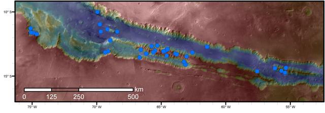
Blue dots on this map indicate sites of recurring slope lineae (RSL) in part of the Valles Marineris canyon network on Mars. RSL are seasonal dark streaks regarded as the strongest evidence for the possibility of liquid water on the surface of modern Mars. The area mapped here has the highest density of known RSL on the Red Planet. The RSL were identified by repeated observations of the sites using the High Resolution Imaging Science Experiment (HiRISE) camera on NASA's Mars Reconnaissance Orbiter. Map colors represent elevation, where red is high and blue is low. Valles Marineris is the largest canyon system in the solar system. The region shown here includes Melas Chasma and Coprates Chasma, in the central and eastern portions of Valles Marineris. The mapped area extends about 1,500 miles (2,400 kilometers) east to west and about 280 miles (450 kilometers) north to south, at latitudes from 9 to 17 degrees south of Mars' equator. The base map uses data from the Mars Orbiter Camera and Mars Orbiter Laser Altimeter of NASA's Mars Global Surveyor mission. RSL extend downslope during a warm season, fade in the colder part of the year, and repeat the process in a subsequent Martian year. A study of 41 RSL sites in this canyon area, published July 7, 2016, provides support for the notion that significant amounts of near-surface water can be found on modern Mars, though the work also indicates that puzzles remain unsolved in understanding how these seasonal features form. Each site includes anywhere from a few to more than 1,000 individual "lineae." http://photojournal.jpl.nasa.gov/catalog/PIA20756
The layered sedimentary deposits inside the giant canyons of Mars have puzzled scientists for decades. These light toned deposits have fine, horizontal laminations that are unlike the rugged rim rock of the Valles Marineris as seen by NASA's Mars Reconnaisance Orbiter (MRO). Various ideas for the origin of the layered sediments have suggested lake deposits, wind blown dust and sand, or volcanic materials that erupted after the canyon was formed, and possibly filled with water. One particular layered deposit, called Ceti Mensa, attracted attention because its deep red color in images collected by the Viking Orbiter mission during the 1970s. Located in west Candor Chasma in the north of the Valles Marineris, Ceti Mensa is an undulating plateau that rises 3 kilometers above the canyon floor and is bounded by steep scarps up to 1.5 kilometers in height. Deep red hues are on the west-facing scarp in particular. The red tint may be due to the presence of crystalline ferric oxide, suggesting that the material may have been exposed to heat or water, or both. Spectral measurements by the Mars Express OMEGA and MRO CRISM instruments confirm the presence of hydrated sulfate salts, such as gypsum and kieserite . These minerals are important for two reasons. On Earth, they typically form in wet environments, suggesting that the deposits in Ceti Mensa may have formed under water. On Mars, these deposits could be valuable to future Martian colonists as fertilizer for growing crops. In a view of the colorful west-facing scarp of Ceti Mensa, we see the interior layers of the deposit, giving us a window into the past history of the sediments as they accumulated over time. We also see layers that were previously too small to view, and a surface that is thoroughly fractured, eroded into knobs, and partially covered by young dark sand dunes. https://photojournal.jpl.nasa.gov/catalog/PIA22051

NASA image release April 6, 2011 Images from Swift's Ultraviolet/Optical (white, purple) and X-ray telescopes (yellow and red) were combined in this view of GRB 110328A. The blast was detected only in X-rays, which were collected over a 3.4-hour period on March 28. Credit: NASA/Swift/Stefan Immler NASA's Swift, Hubble Space Telescope and Chandra X-ray Observatory have teamed up to study one of the most puzzling cosmic blasts yet observed. More than a week later, high-energy radiation continues to brighten and fade from its location. Astronomers say they have never seen anything this bright, long-lasting and variable before. Usually, gamma-ray bursts mark the destruction of a massive star, but flaring emission from these events never lasts more than a few hours. Although research is ongoing, astronomers say that the unusual blast likely arose when a star wandered too close to its galaxy's central black hole. Intense tidal forces tore the star apart, and the infalling gas continues to stream toward the hole. According to this model, the spinning black hole formed an outflowing jet along its spin axis. A powerful blast of X- and gamma rays is seen if this jet is pointed in our direction. To read more go to: <a href="http://www.nasa.gov/topics/universe/features/star-disintegration.." rel="nofollow">www.nasa.gov/topics/universe/features/star-disintegration..</a>. NASA Goddard Space Flight Center enables NASA’s mission through four scientific endeavors: Earth Science, Heliophysics, Solar System Exploration, and Astrophysics. Goddard plays a leading role in NASA’s accomplishments by contributing compelling scientific knowledge to advance the Agency’s mission. Follow us on Twitter Join us on Facebook
NASA's Hubble Space Telescope has helped astronomers find the final piece of a celestial puzzle by nabbing a third runaway star. As British royal families fought the War of the Roses in the 1400s for control of England's throne, a grouping of stars was waging its own contentious skirmish — a star war far away in the Orion Nebula. The stars were battling each other in a gravitational tussle, which ended with the system breaking apart and at least three stars being ejected in different directions. The speedy, wayward stars went unnoticed for hundreds of years until, over the past few decades, two of them were spotted in infrared and radio observations, which could penetrate the thick dust in the Orion Nebula. Read more: <a href="https://go.nasa.gov/2ni3EZX" rel="nofollow">go.nasa.gov/2ni3EZX</a> <b><a href="http://www.nasa.gov/audience/formedia/features/MP_Photo_Guidelines.html" rel="nofollow">NASA image use policy.</a></b> <b><a href="http://www.nasa.gov/centers/goddard/home/index.html" rel="nofollow">NASA Goddard Space Flight Center</a></b> enables NASA’s mission through four scientific endeavors: Earth Science, Heliophysics, Solar System Exploration, and Astrophysics. Goddard plays a leading role in NASA’s accomplishments by contributing compelling scientific knowledge to advance the Agency’s mission. <b>Follow us on <a href="http://twitter.com/NASAGoddardPix" rel="nofollow">Twitter</a></b> <b>Like us on <a href="http://www.facebook.com/pages/Greenbelt-MD/NASA-Goddard/395013845897?ref=tsd" rel="nofollow">Facebook</a></b> <b>Find us on <a href="http://instagrid.me/nasagoddard/?vm=grid" rel="nofollow">Instagram</a></b>
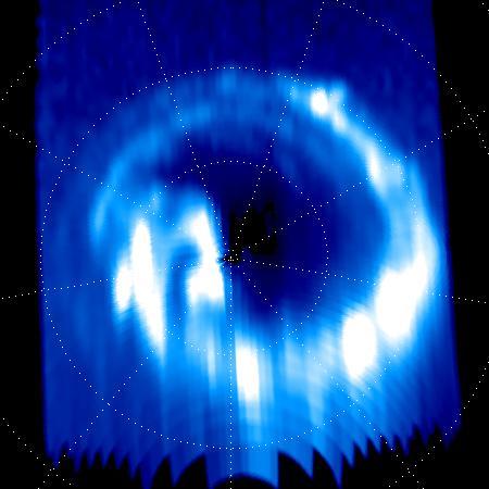
On Sept. 14, 2017, one day before making its final plunge into Saturn's atmosphere, NASA's Cassini spacecraft used its Ultraviolet Imaging Spectrograph, or UVIS, instrument to capture this final view of ultraviolet auroral emissions in the planet's north polar region. The view is centered on the north pole of Saturn, with lines of latitude visible for 80, 70 and 60 degrees. Lines of longitude are spaced 40 degrees apart. The planet's day side is at bottom, while the night side is at top. A sequence of images from this observation has also been assembled into a movie sequence. The last image in the movie was taken about an hour before the still image, which was the actual final UVIS auroral image. Auroral emissions are generated by charged particles traveling along the invisible lines of Saturn's magnetic field. These particles precipitate into the atmosphere, releasing light when they strike gas molecules there. Several individual auroral structures are visible here, despite that this UVIS view was acquired at a fairly large distance from the planet (about 424,000 miles or 683,000 kilometers). Each of these features is connected to a particular phenomenon in Saturn's magnetosphere. For instance, it is possible to identify auroral signatures here that are related to the injection of hot plasma from the dayside magnetosphere, as well as auroral features associated with a change in the magnetic field's shape on the magnetosphere's night side. Several possible scenarios have been postulated over the years to explain Saturn's changing auroral emissions, but researchers are still far from a complete understanding of this complicated puzzle. Researchers will continue to analyze the hundreds of image sequences UVIS obtained of Saturn's auroras during Cassini's 13-year mission, with many new discoveries likely to be made. This image and movie sequence were produced by the Laboratory for Planetary and Atmospheric Physics (LPAP) of the STAR Institute of the University of Liege in Belgium, in collaboration with the UVIS Team. The animation is available at https://photojournal.jpl.nasa.gov/catalog/PIA21899

This photograph shows the Compton Gamma-Ray Observatory being released from the Remote Manipulator System (RMS) arm aboard the Space Shuttle Atlantis during the STS-35 mission in April 1991. The GRO reentered the Earth's atmosphere and ended its successful mission in June 2000. For nearly 9 years, GRO's Burst and Transient Source Experiment (BATSE), designed and built by the Marshall Space Flight Center, kept an unblinking watch on the universe to alert scientist to the invisible, mysterious gamma-ray bursts that had puzzled them for decades. By studying gamma-rays from objects like black holes, pulsars, quasars, neutron stars, and other exotic objects, scientists could discover clues to the birth, evolution, and death of star, galaxies, and the universe. The gamma-ray instrument was one of four major science instruments aboard the Compton. It consisted of eight detectors, or modules, located at each corner of the rectangular satellite to simultaneously scan the entire universe for bursts of gamma-rays ranging in duration from fractions of a second to minutes. In January 1999, the instrument, via the Internet, cued a computer-controlled telescope at Las Alamos National Laboratory in Los Alamos, New Mexico, within 20 seconds of registering a burst. With this capability, the gamma-ray experiment came to serve as a gamma-ray burst alert for the Hubble Space Telescope, the Chandra X-Ray Observatory, and major gound-based observatories around the world. Thirty-seven universities, observatories, and NASA centers in 19 states, and 11 more institutions in Europe and Russia, participated in BATSE's science program.
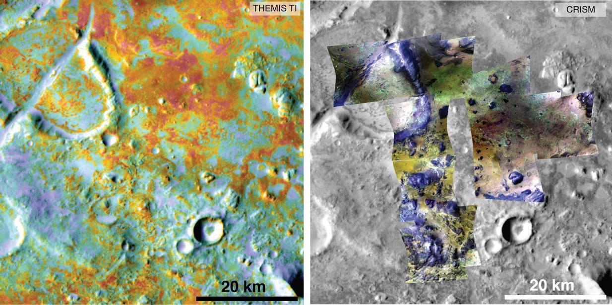
Researchers estimating the amount of carbon held in the ground at the largest known carbonate-containing deposit on Mars utilized data from three different NASA Mars orbiters. Each image in this pair covers the same area about 36 miles (58 kilometers) wide in the Nili Fossae plains region of Mars' northern hemisphere. The tally of carbon content in the rocks of this region is a key piece in solving a puzzle of how the Martian atmosphere has changed over time. Carbon dioxide from the atmosphere on early Mars reacted with surface rocks to form carbonate, thinning the atmosphere. The image on the left presents data from the Thermal Emission Imaging System (THEMIS) instrument on NASA's Mars Odyssey orbiter. The color coding indicates thermal inertia -- the property of how quickly a surface material heats up or cools off. Sand, for example (blue hues), cools off quicker after sundown than bedrock (red hues) does. The color coding in the image on the right presents data from the Compact Reconnaissance Imaging Spectrometer for Mars (CRISM) instrument on NASA's Mars Reconnaissance Orbiter. From the brightness at many different wavelengths, CRISM data can indicate what minerals are present on the surface. In the color coding used here, green hues are consistent with carbonate-bearing materials, while brown or yellow hues are olivine-bearing sands and locations with purple hues are basaltic in composition. The gray scale base map is a mosaic of daytime THEMIS infrared images. Annotations point to areas with different surface compositions. The scale bar indicates 20 kilometers (12.4 miles). http://photojournal.jpl.nasa.gov/catalog/PIA19816

The surface of Jupiter's moon Europa features a widely varied landscape, including ridges, bands, small rounded domes and disrupted spaces that geologists called "chaos terrain." This newly reprocessed image, along with two others along the same longitude (see PIA23871 and PIA23872), were taken by NASA's Galileo spacecraft on Sept. 26, 1998, and reveal details of diverse surface features on Europa. All three images were captured along the same longitude of Europa as Galileo flew by on Sept. 26, 1998, in the spacecraft's 17th orbit of Jupiter (orbit E17). It was the eighth of Galileo's 11 targeted flybys of Europa. High-resolution images were taken through a clear filter in grayscale (black and white). Using lower-resolution, color images of the same region from a different flyby (orbit E14), technicians recently mapped color onto the higher-resolution images. (Orbit E14 resulted in this global view of Europa (see PIA19048). The color information gathered on that flyby was used to reprocess these new images.) Enhanced-color images like these allow scientists to highlight geologic features with different colors, which are related to chemical compositions of the surface. Areas that appear light blue or white are made up of relatively pure water ice, and reddish areas have more non-ice materials. This image shows a region of blocky chaos terrain, where the surface has broken apart into many smaller chaos blocks that are surrounded by featureless matrix material. Many of the chaos blocks have moved sideways, rotated, or tilted before being refrozen into their new locations, and some larger blocks preserve features of the pre-existing terrain before it was broken up. Using these features as clues, scientists have been able to reconstruct some chaos regions like jjgsaw puzzles to track the motion of blocks. Cutting through the chaos terrain near the bottom, from left to right, is a broad flat band. Called Agenor Linea, it is one of the longest bands on Europa and is distinctive for its two-color appearance, with a bright region at the top and a darker region below. Another rare bright band, Katreus Linea, cuts across the top portion of this image. The image resolution is 243 yards (222 meters) per pixel, and this image depicts an area about 170 miles (280 kilometers) across. This image was produced by Mario Valenti at the SETI Institute in Mountain View, Calif. https://photojournal.jpl.nasa.gov/catalog/PIA23873
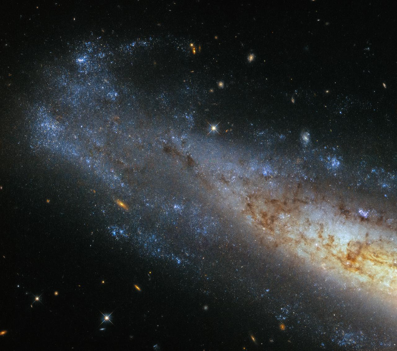
This image from Hubble’s Wide Field Camera 3 (WFC3) shows a section of NGC 1448, a spiral galaxy located about 50 million light-years from Earth in the little-known constellation of Horologium (The Pendulum Clock). We tend to think of spiral galaxies as massive and roughly circular celestial bodies, so this glittering oval does not immediately appear to fit the visual bill. What’s going on? Imagine a spiral galaxy as a circular frisbee spinning gently in space. When we see it face on, our observations reveal a spectacular amount of detail and structure — a great example from Hubble is the telescope’s view of Messier 51, otherwise known as the Whirlpool Galaxy. However, the NGC 1448 frisbee is very nearly edge-on with respect to Earth, giving it an appearance that is more oval than circular. The spiral arms, which curve out from NGC 1448’s dense core, can just about be seen. Although spiral galaxies might appear static with their picturesque shapes frozen in space, this is very far from the truth. The stars in these dramatic spiral configurations are constantly moving as they orbit around the galaxy’s core, with those on the inside making the orbit faster than those sitting further out. This makes the formation and continued existence of a spiral galaxy’s arms something of a cosmic puzzle, because the arms wrapped around the spinning core should become wound tighter and tighter as time goes on — but this is not what we see. This is known as the winding problem. Credit: ESA/Hubble & NASA #nasagoddard #space #science #Hubble #star <b><a href="http://www.nasa.gov/audience/formedia/features/MP_Photo_Guidelines.html" rel="nofollow">NASA image use policy.</a></b> <b><a href="http://www.nasa.gov/centers/goddard/home/index.html" rel="nofollow">NASA Goddard Space Flight Center</a></b> enables NASA’s mission through four scientific endeavors: Earth Science, Heliophysics, Solar System Exploration, and Astrophysics. Goddard plays a leading role in NASA’s accomplishments by contributing compelling scientific knowledge to advance the Agency’s mission. <b>Follow us on <a href="http://twitter.com/NASAGoddardPix" rel="nofollow">Twitter</a></b> <b>Like us on <a href="http://www.facebook.com/pages/Greenbelt-MD/NASA-Goddard/395013845897?ref=tsd" rel="nofollow">Facebook</a></b> <b>Find us on <a href="http://instagrid.me/nasagoddard/?vm=grid" rel="nofollow">Instagram</a></b>

Panta rhei is a simplified version of the famous Greek philosopher Heraclitus' teachings. It basically means, everything flows. And everything in the Universe is indeed continually on the move, spiraling and shifting through space. Some cosmic objects move a little further than others — take the subject of this NASA/ESA Hubble Space Telescope image, a globular cluster of stars known as Palomar 12. Although it currently lies on the outskirts of the Milky Way’s halo, Palomar 12 was not born here. When astronomers first studied this cluster, they were puzzled by its strangely young age when compared to the other clusters in the galaxy. It appeared to be around 30 percent younger than other Milky Way globulars. Surely if it had been born within our galaxy, it would have sprung to life at a similar time to its cluster companions? A bit more digging revealed that Palomar 12 was actually ripped from its initial home, the Sagittarius Dwarf Elliptical galaxy, around 1.7 billion years ago via tidal interactions between its former home and our galaxy. The dwarf galaxy that Palomar 12 once called home is a satellite galaxy to ours, and closely orbits around us — even occasionally passing through the plane of our galaxy. In fact, it is being slowly torn apart and consumed by the Milky Way. The sparkling stars in this picture were imaged by Hubble’s Advanced Camera for Surveys. Credit: ESA/NASA <b><a href="http://www.nasa.gov/audience/formedia/features/MP_Photo_Guidelines.html" rel="nofollow">NASA image use policy.</a></b> <b><a href="http://www.nasa.gov/centers/goddard/home/index.html" rel="nofollow">NASA Goddard Space Flight Center</a></b> enables NASA’s mission through four scientific endeavors: Earth Science, Heliophysics, Solar System Exploration, and Astrophysics. Goddard plays a leading role in NASA’s accomplishments by contributing compelling scientific knowledge to advance the Agency’s mission. <b>Follow us on <a href="http://twitter.com/NASAGoddardPix" rel="nofollow">Twitter</a></b> <b>Like us on <a href="http://www.facebook.com/pages/Greenbelt-MD/NASA-Goddard/395013845897?ref=tsd" rel="nofollow">Facebook</a></b> <b>Find us on <a href="http://instagram.com/nasagoddard?vm=grid" rel="nofollow">Instagram</a></b>