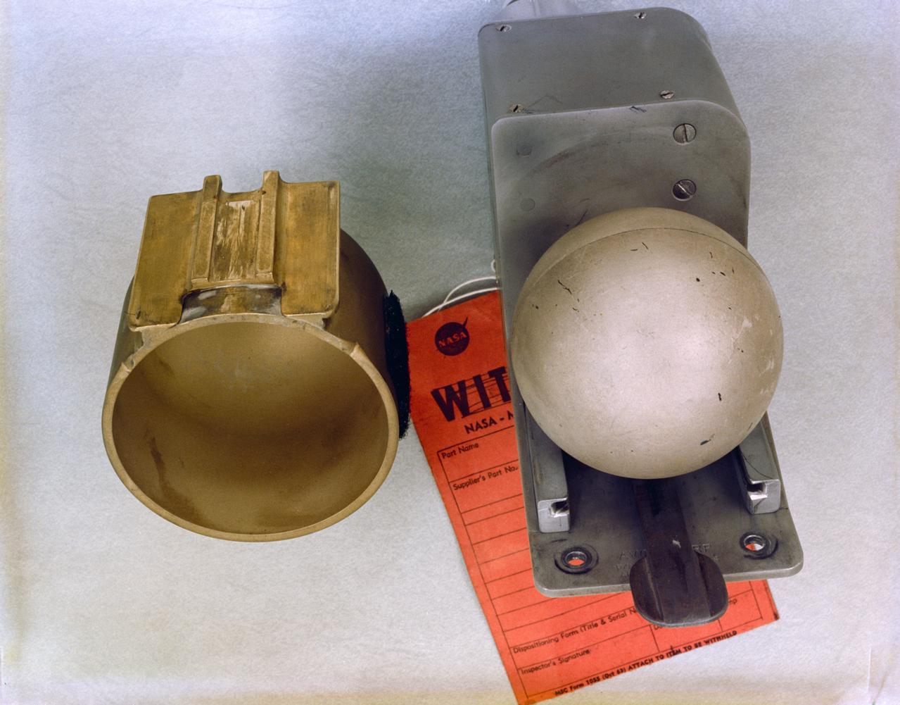
S65-58941 (27 Aug. 1965) --- U.S. Air Force Weapons Laboratory D-8 (Radiation in Space) experiment for Gemini-6 spaceflight. Kennedy Space Center alternative photo number is 104-KSC-65C-5533. Photo credit: NASA
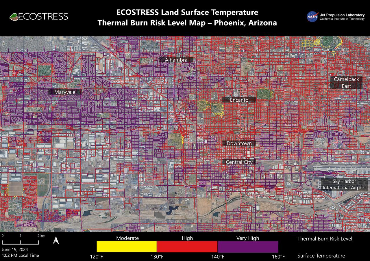
Data from NASA's ECOSTRESS (Ecosystem Spaceborne Thermal Radiometer Experiment on Space Station) instrument was used to map scorching pavement in Phoenix where contact with skin can cause serious burns. Based on measurements captured at 1:02 p.m. local time on June 19, 2024, the image shows land surface temperatures across a grid of roads and adjacent sidewalks, revealing how urban spaces can turn hazardous during hot weather. The Arizona city's miles of asphalt and concrete surfaces (colored here in yellow, red, and purple, based on temperature) trap heat, as the image indicates. The surfaces registered at least 120 degrees Fahrenheit (49 degrees Celsius) to the touch – hot enough to cause contact burns in minutes to seconds. At the lower right of the image is Phoenix Sky Harbor International Airport, where ECOSTRESS recorded some of the hottest land surface temperatures within the city – around 140 F (60 C). The air temperature on June 19 at the airport reached 106 F (43 C). Air temperature, which is measured out of direct sunlight, can differ significantly from the temperature at the land surface. Streets are often the hottest surfaces of the built environment due to dark asphalt paving that absorbs more sunlight than lighter-colored surfaces; asphalt absorbs up to 95% of solar radiation. These types of surfaces can easily be 40 to 60 degrees F (22 to 33 degrees C) hotter than the air temperature on a very hot day. Launched to the International Space Station in 2018, ECOSTRESS measures temperatures at the highest spatial resolution of any space-based instrument, producing images with a typical pixel size of about 225 feet (70 meters) by 125 feet (38 meters). The image of Phoenix was produced at higher spatial resolution using a machine learning algorithm that incorporates data from additional satellites: NASA/USGS Landsat and Sentinel-2. The combined measurements were used to "sharpen" the surface temperatures to a resolution of 100 feet (30 meters) by 100 feet (30 meters). https://photojournal.jpl.nasa.gov/catalog/PIA25529
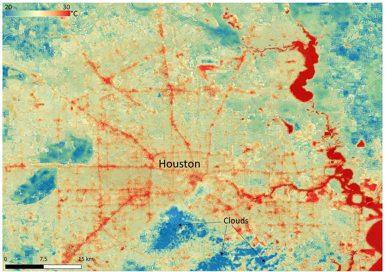
NASA's Ecosystem Spaceborne Thermal Radiometer Experiment on Space Station (ECOSTRESS) instrument recorded this image of ground surface temperatures in Houston and its environs on June 20, 2022, at 6:29 a.m. Central Daylight Time. Even just after sunrise, manmade urban surfaces near the city center and transportation networks – streets, roads, and highways shown in red and orange – were significantly warmer than the outskirts by up to 18 degrees Fahrenheit (10 degrees Celsius). Clouds, which are cool compared with the ground, are shown in blue and labeled in the image. Cities are usually warmer than open land because of human activities and the materials used in building and construction. Streets are often the hottest part of the built environment due to asphalt paving. Dark-colored surfaces absorb more heat from the Sun than lighter-colored ones; asphalt absorbs up to 95% of solar radiation and retains the heat for hours into the nighttime. ECOSTRESS measures the temperature of the ground, which is hotter than the air temperature during the daytime. The instrument launched to the space station in 2018. Its primary mission is to identify plants' thresholds for water use and water stress, giving insight into their ability to adapt to a warming climate. However, ECOSTRESS is also useful for documenting other heat-related phenomena, like patterns of heat absorption and retention. Its high-resolution images, with a pixel size of about 225 feet (70 meters) by 125 feet (38 meters), are a powerful tool for understanding our environment. https://photojournal.jpl.nasa.gov/catalog/PIA25421
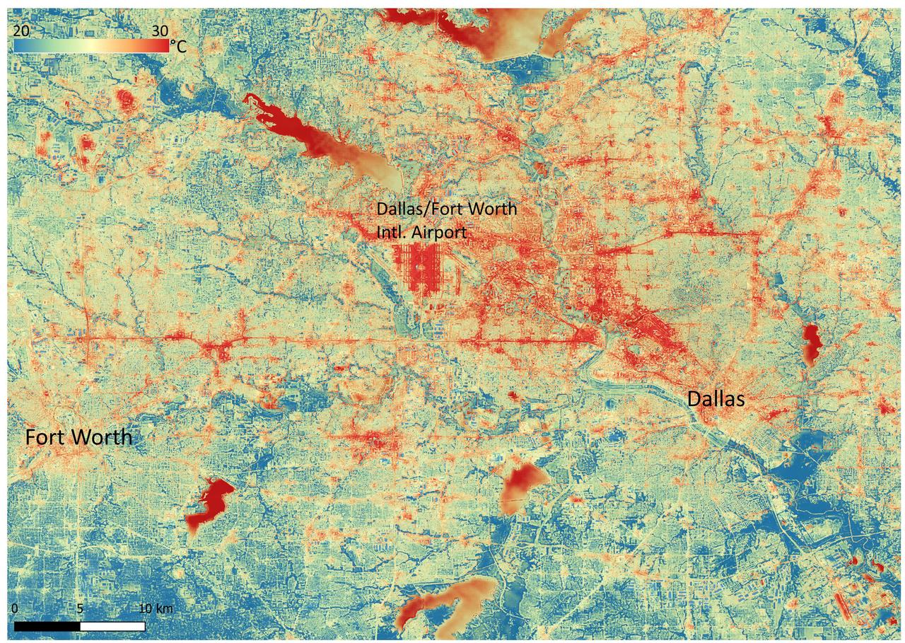
NASA's Ecosystem Spaceborne Thermal Radiometer Experiment on Space Station (ECOSTRESS) instrument recorded this image of ground surface temperatures in Dallas and Fort Worth, Texas, on June 20, 2022, at 7:17 a.m. Central Daylight Time. Even early in the day, manmade urban surfaces near city centers and transportation networks – streets, roads, and highways shown in red and orange – are warmer than the outskirts by up to 18 degrees Fahrenheit (10 degrees Celsius). The paved surfaces at Dallas/Fort Worth International Airport, shown in red near the top-center of the image, had the warmest temperatures, exceeding 86 F (30 C). Natural land surfaces such as vegetation and streams in rural areas, shown in green and blue, are cooler than nearby large bodies of water, shown in red and yellow, that tend to retain more heat overnight due to their higher heat capacity. Cities are usually warmer than open land because of human activities and the materials used in building and construction. Streets are often the hottest part of the built environment due to asphalt paving. Dark-colored surfaces absorb more heat from the Sun than lighter-colored ones; asphalt absorbs up to 95% of solar radiation and retains the heat for hours into the nighttime. ECOSTRESS measures the temperature of the ground, which is hotter than the air temperature during the daytime. The instrument launched to the space station in 2018. Its primary mission is to identify plants' thresholds for water use and water stress, giving insight into their ability to adapt to a warming climate. However, ECOSTRESS is also useful for documenting other heat-related phenomena, like patterns of heat absorption and retention. Its high-resolution images, with a pixel size of about 225 feet (70 meters) by 125 feet (38 meters), are a powerful tool for understanding our environment. https://photojournal.jpl.nasa.gov/catalog/PIA25422
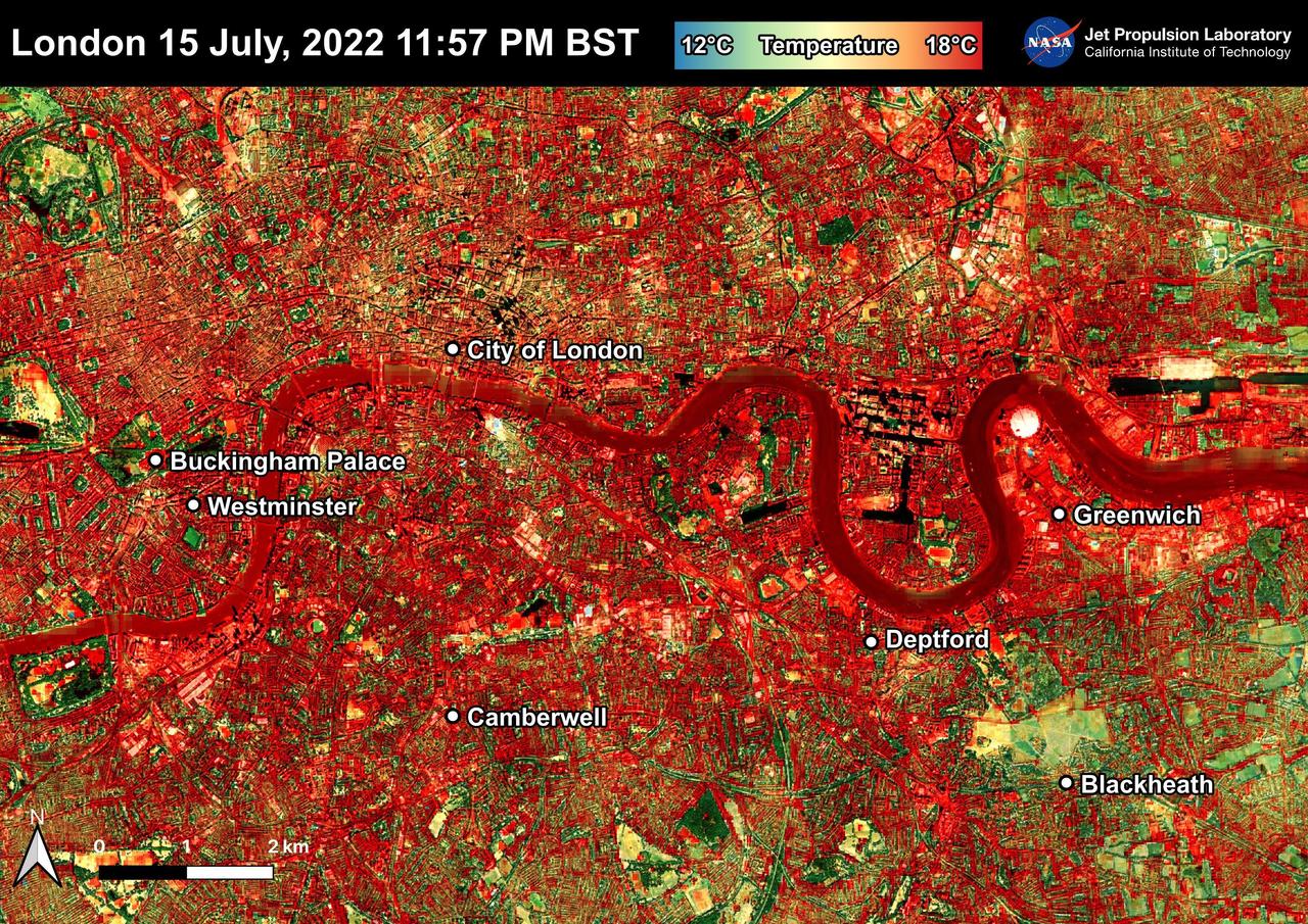
NASA's Ecosystem Spaceborne Thermal Radiometer Experiment on Space Station (ECOSTRESS) instrument recorded this image of ground surface temperatures in London and surrounding areas on July 15, 2022, just before midnight local time. It shows surface temperatures exceeding 68 degrees Fahrenheit (20 degrees Celsius) at 11:57 p.m. British Summer Time. Parts of Europe in mid-July experienced a record-breaking heat wave. The United Kingdom reaching its highest air temperature on record on July 19, 104.5 F (40.3 C) in Coningsby, about 110 miles (177 kilometers) north of London, which itself saw a high of 104.3 F (40.2 C) the same day. That evening, the overnight low was also a record-breaker: 78.4 F (25.8 C) at Kenley Airfield in Greater London. In this image, the red areas indicate hotter temperatures commonly associated with developed areas. These surfaces – roofs, paved streets, and other built structures – remain warm long after the sun sets. Blue and green areas indicate cooler areas commonly associated with parks and other natural land surfaces. Because this image was acquired at night, it shows bodies of water being warmer than the land surface. This is because water tends to change temperature more slowly, so its temperature stays elevated long after land surfaces have cooled down. Cities are usually warmer than open land with natural surfaces because of human activities as well as the materials used in building and construction. Streets are often the hottest part of the built environment due to asphalt paving. Dark-colored surfaces absorb more heat from the Sun than lighter-colored ones; asphalt absorbs up to 95% of solar radiation and retains the heat for hours into nighttime. This image overlays ECOSTRESS surface temperature data on a Google satellite map for context. ECOSTRESS measures the temperature of the ground, which is hotter than the air temperature during the daytime. The instrument launched to the space station in 2018. Its primary mission is to identify plants' thresholds for water use and water stress, giving insight into their ability to adapt to a warming climate. However, ECOSTRESS is also useful for documenting other heat-related phenomena, like patterns of heat absorption and retention. Its high-resolution images, with a pixel size of about 225 feet (70 meters) by 125 feet (38 meters), are a powerful tool for understanding our environment. https://photojournal.jpl.nasa.gov/catalog/PIA25423