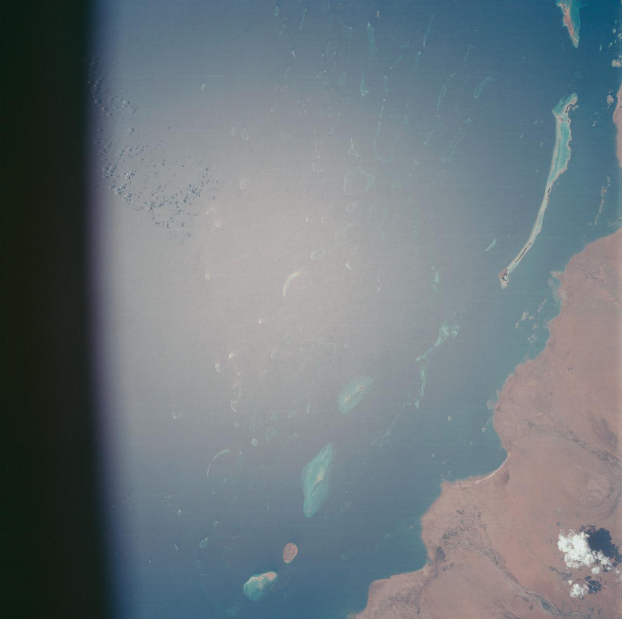
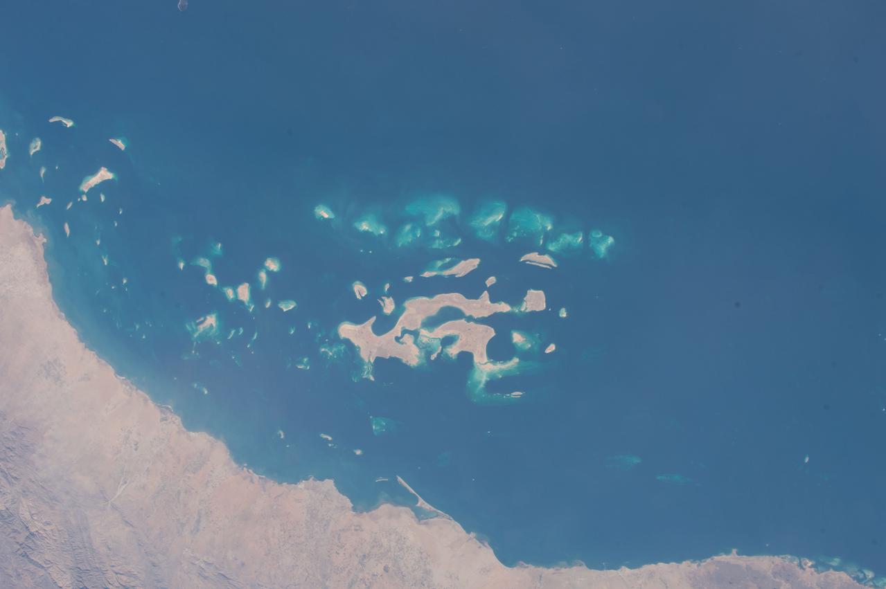
AS07-07-1774 (15 Oct. 1968) --- Red Sea coastal area of Saudi Arabia as seen from the Apollo 7 spacecraft during its 58th revolution of Earth. This picture shows extent of coral reefs in the Red Sea. Photographed from an altitude of 88 nautical miles, at ground elapsed time of 91 hours and 17 minutes.
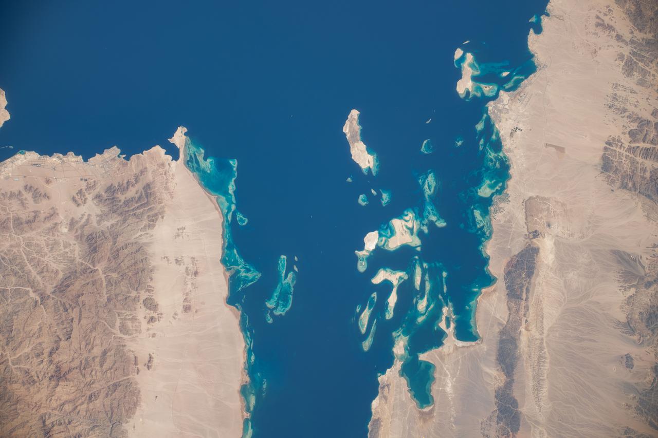
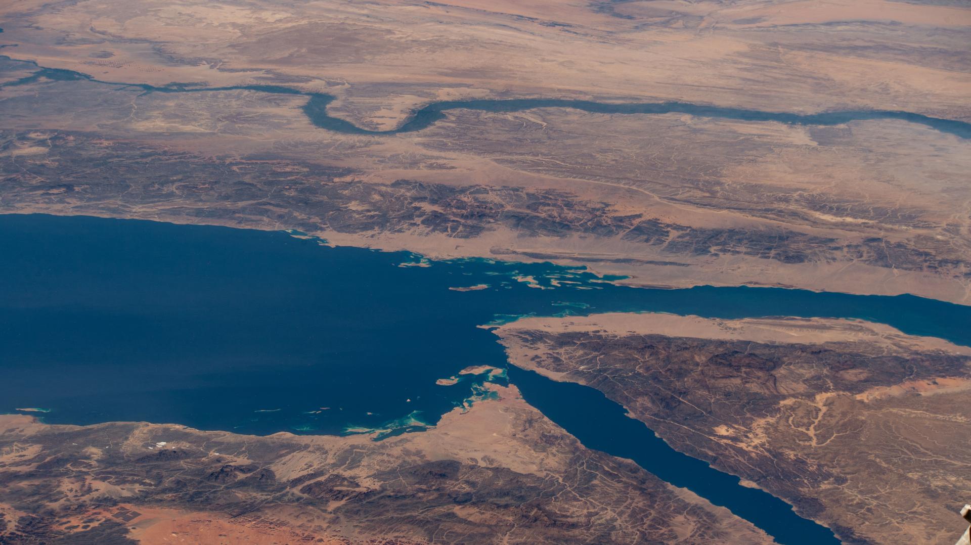
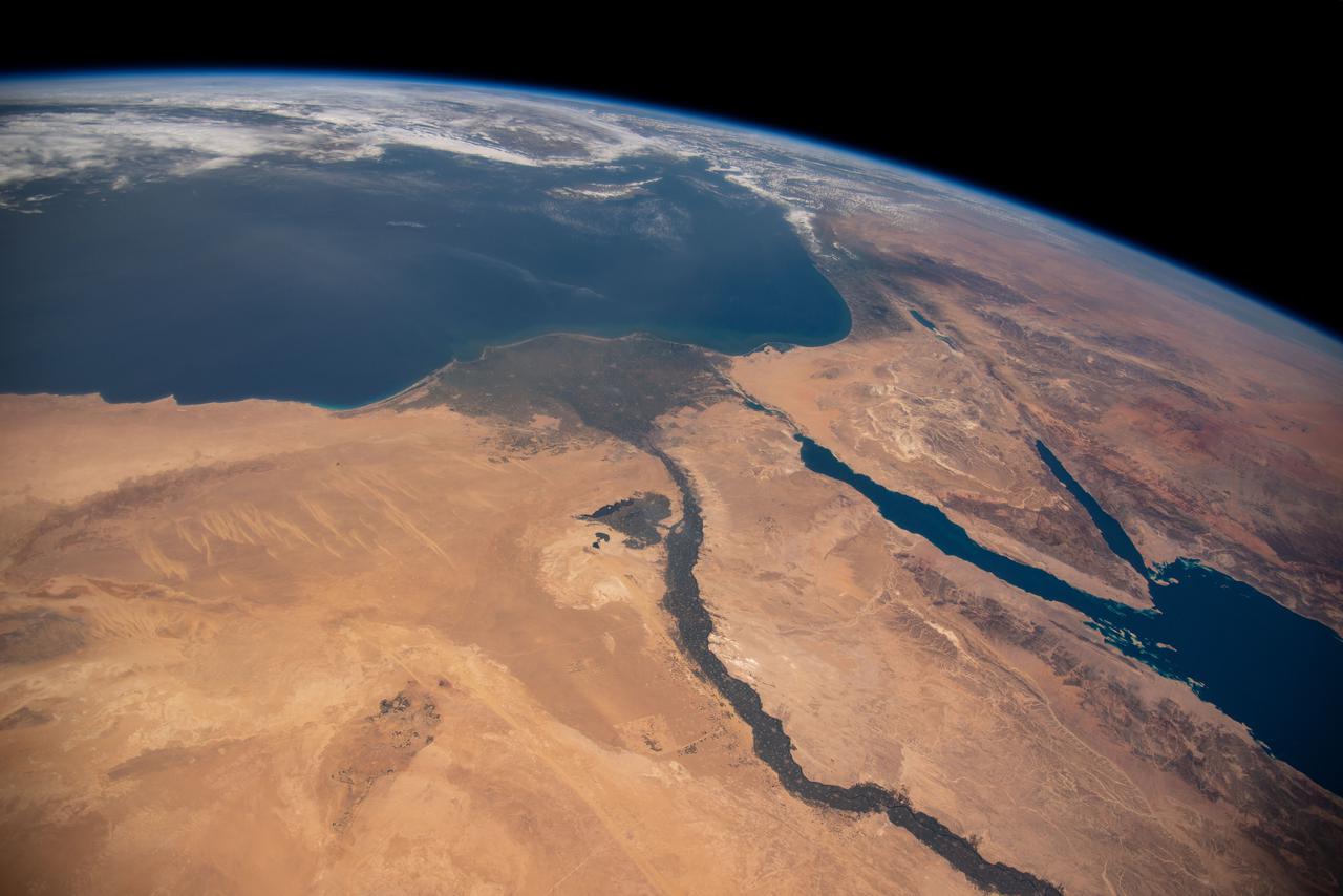
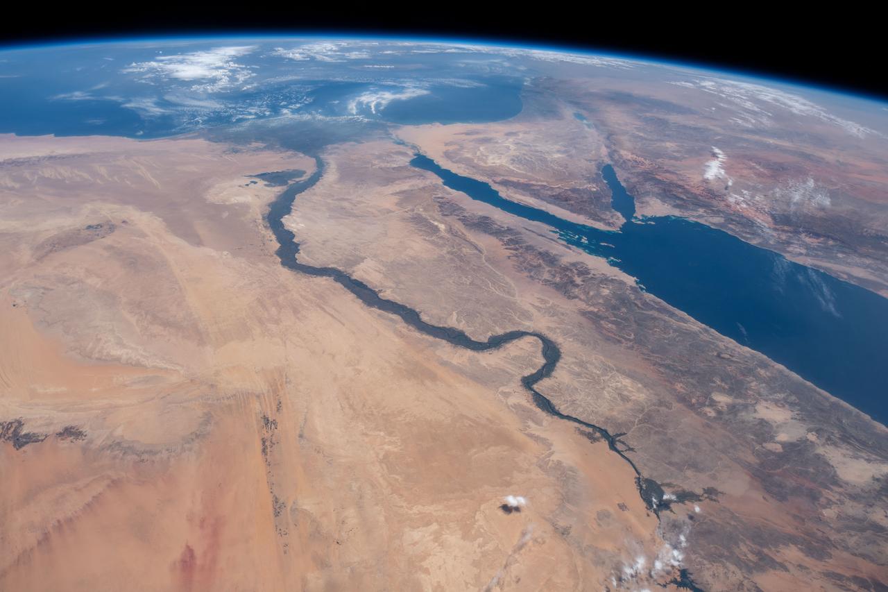
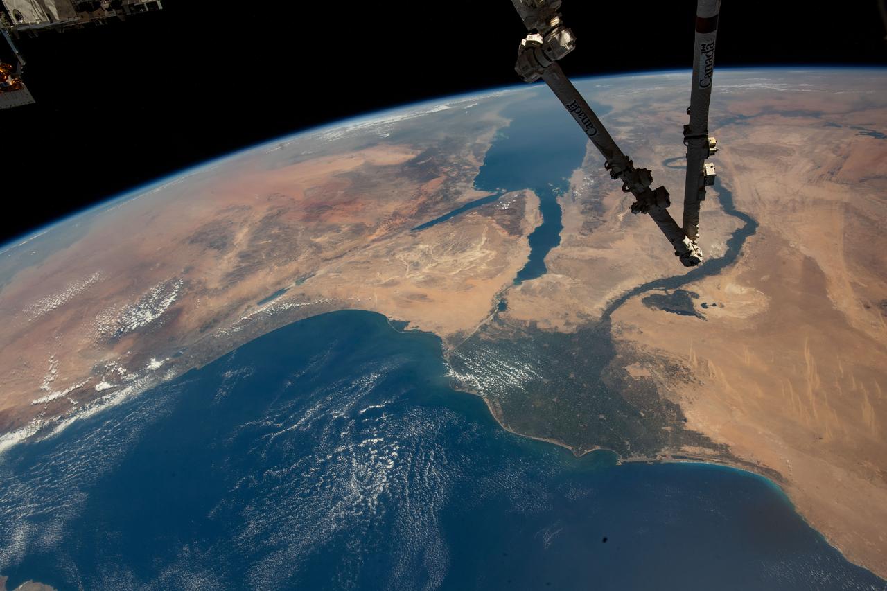
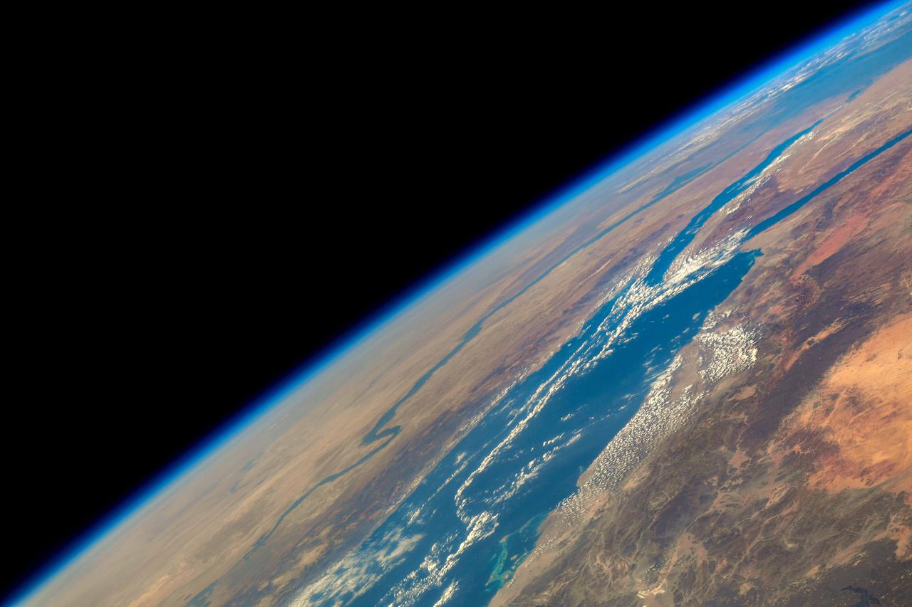
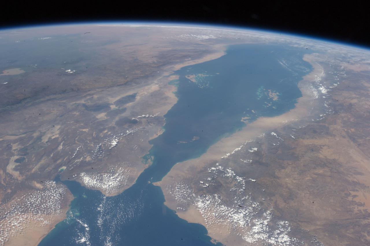
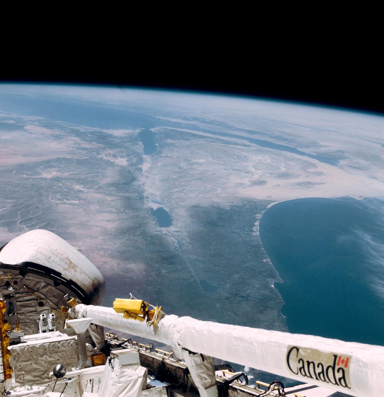
iss071e183808 (June 14, 2024) -- The mouth of the Gulf of Suez feeds into the Red Sea as the International Space Station orbited 262 miles above Egypt.
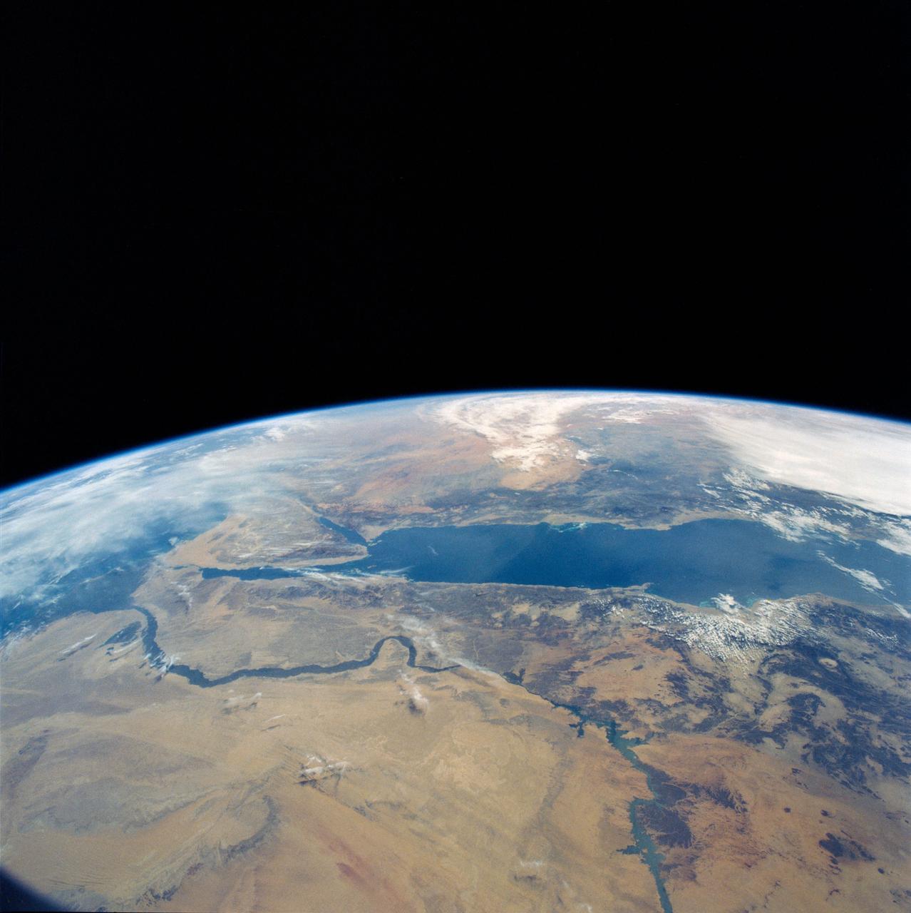
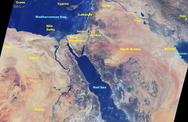
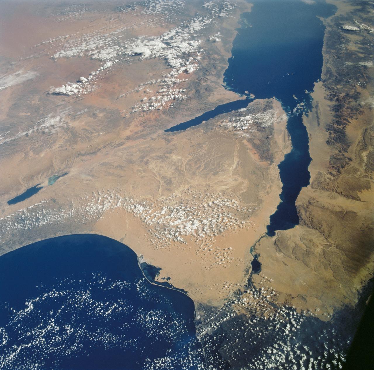
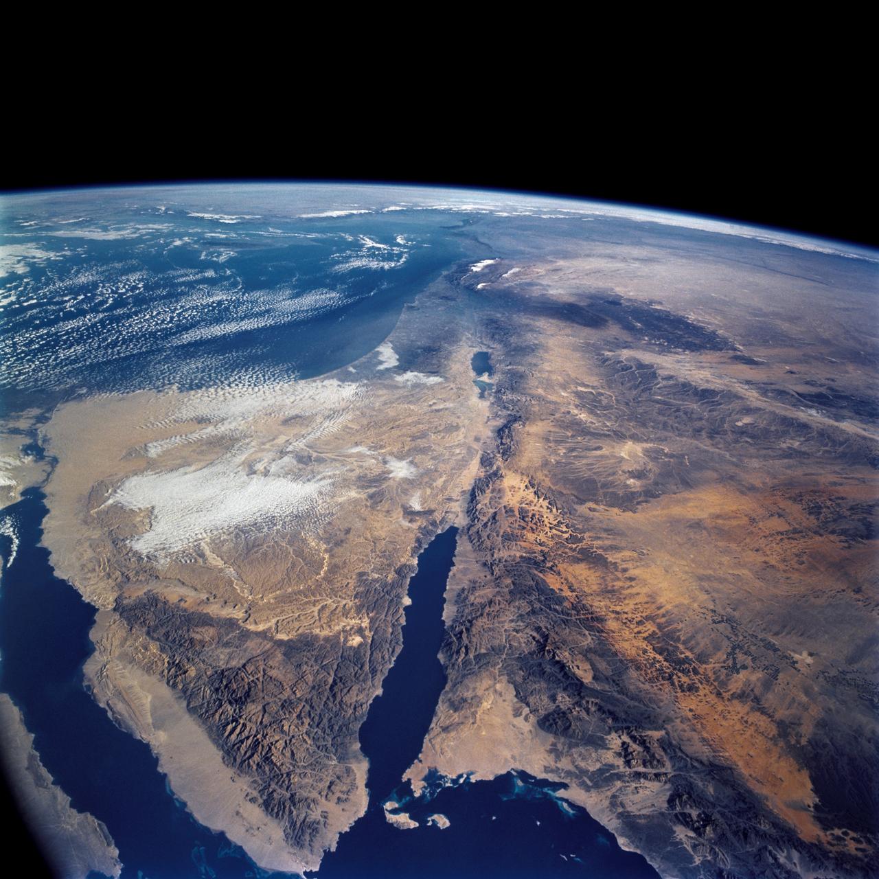
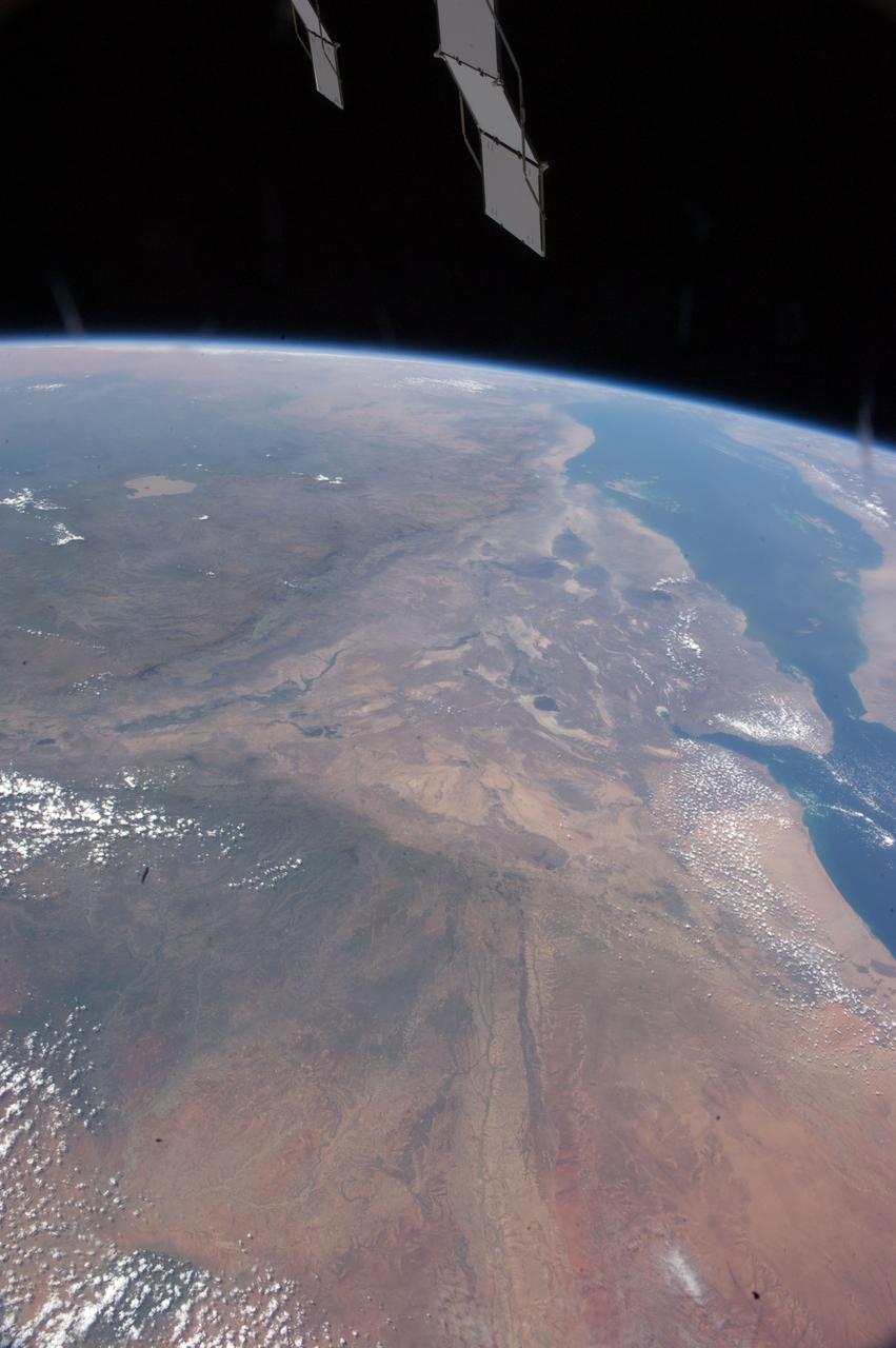
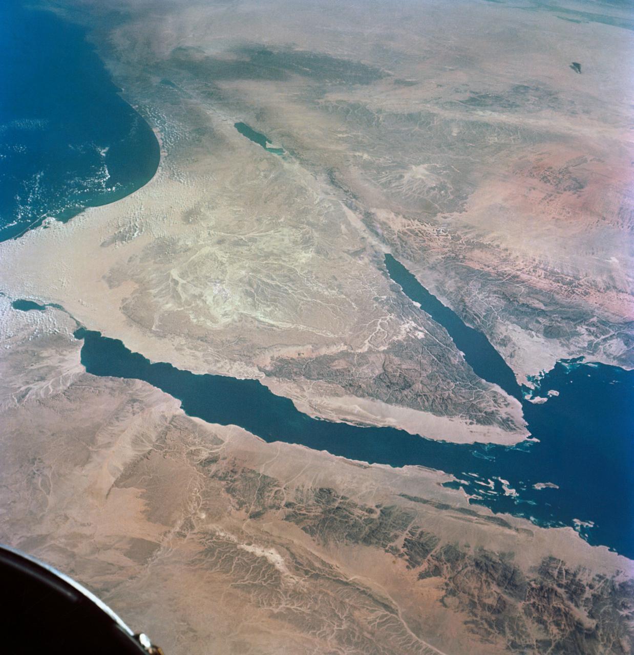
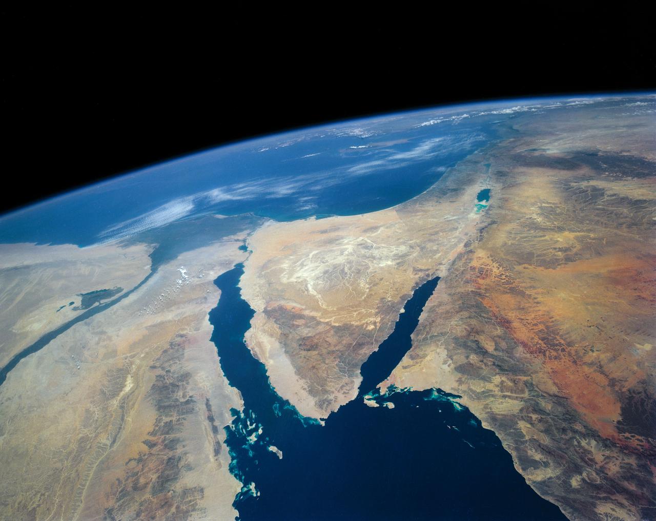
An excellent panoramic view of the entire Sinai Peninsula (29.0N, 34.0E) and the nearby Nile River Delta and eastern Mediterranean coastal region. The Suez Canal, at the top of the scene just to the right of the Delta, connects the Mediterranean Sea with the Gulf of Suez on the west side of the Sinai Peninsula and the Gulf of Aqaba is on the west where they both flow into the Red Sea. At upper right, is the Dead Sea, Jordan River and Lake Tiberius.
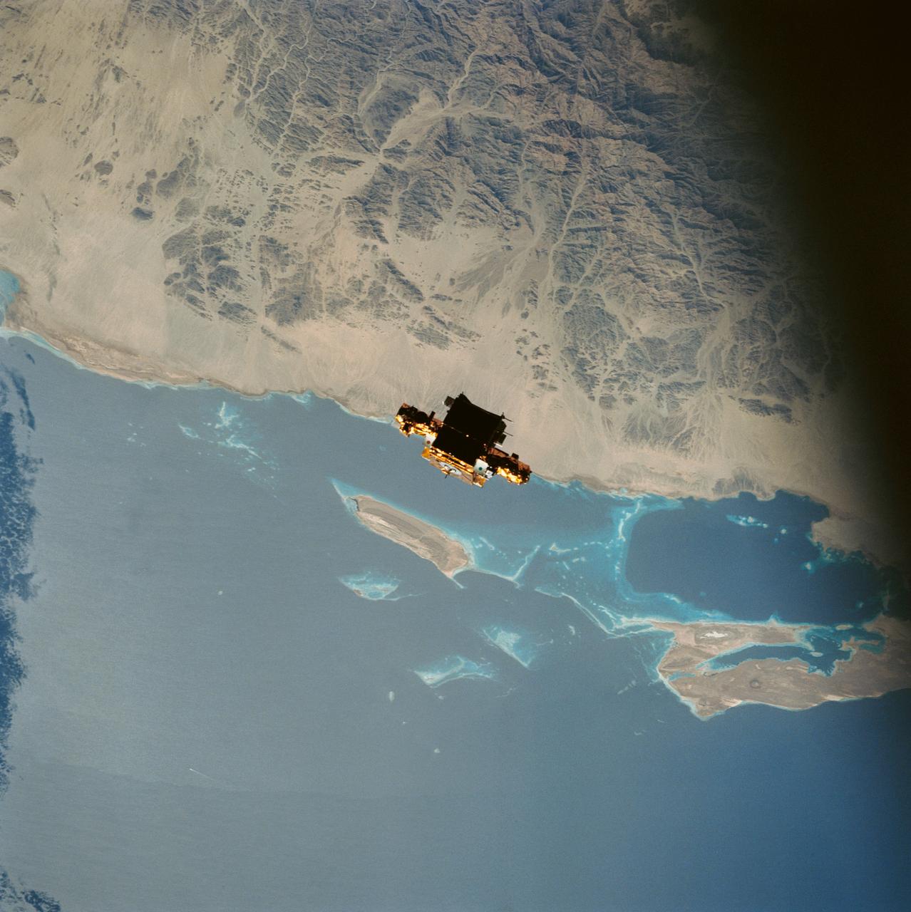
During STS-56, the Shuttle Pointed Autonomous Research Tool for Astronomy 201 (SPARTAN-201), a freeflying payload, was captured on 70mm film as it drifts over the Red Sea coast of Sudan. SPARTAN-201 was photographed by the crewmembers aboard Discovery, Orbiter Vehicle (OV) 103. On the mission's third day, crewmembers used the remote manipulator system (RMS) to lift the satellite from its support structure in OV-103's payload bay (PLB) and release it into space. SPARTAN-201 was later recaptured by OV-103's RMS and returned to Earth with the astronaut crew. The cape structure in the background is Ras abu Shagara, north of Port Sudan.
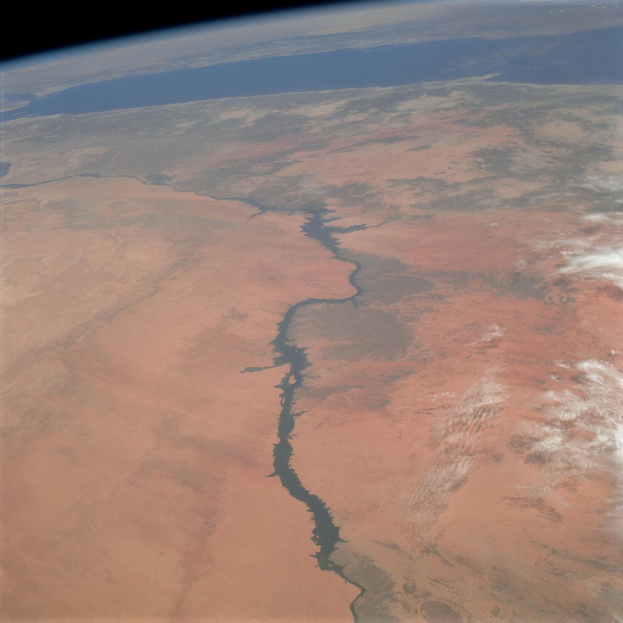
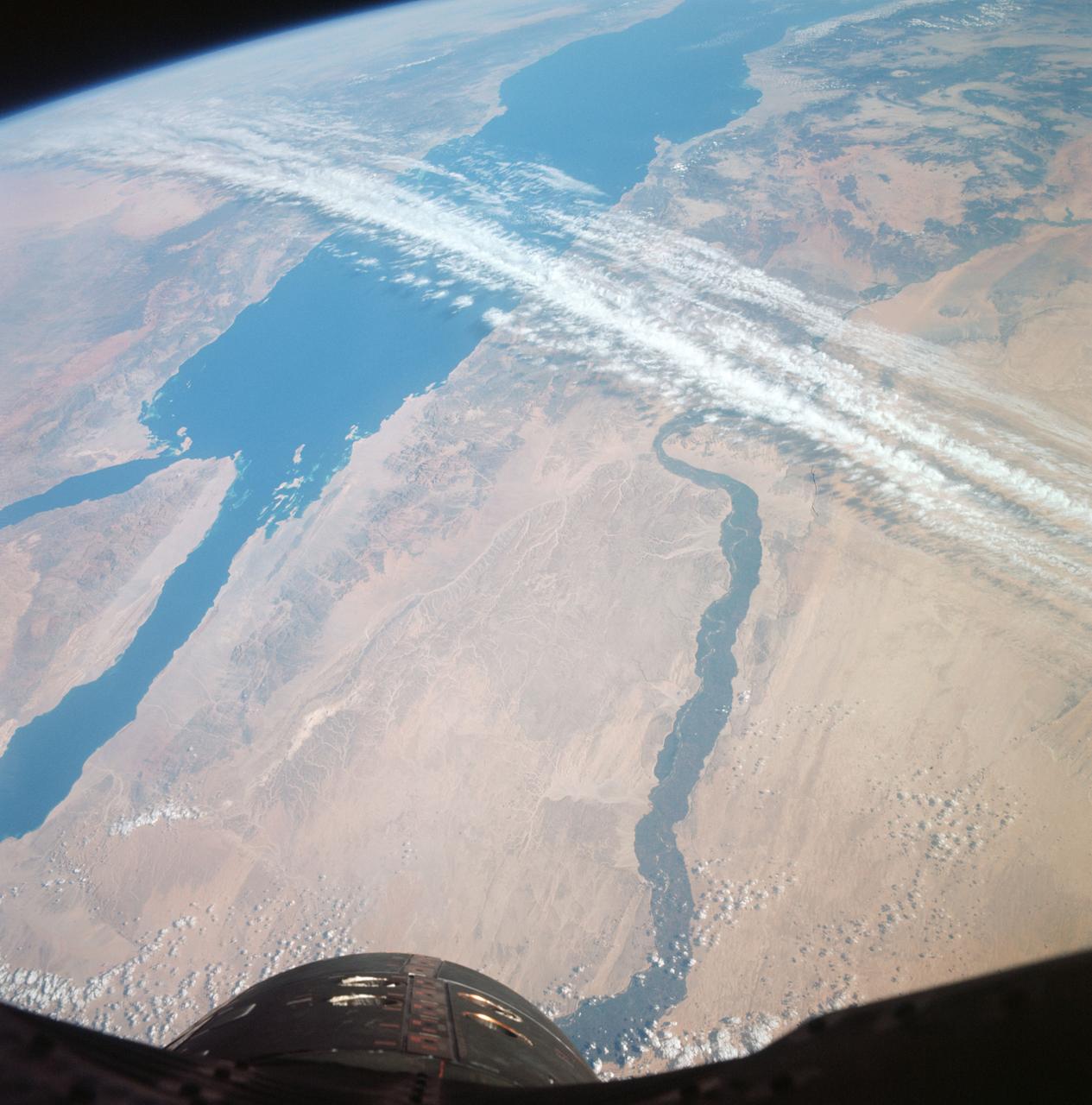
STS031-79-015 (24-29 April 1990) --- The 330-plus nautical mile orbital altitude of the Space Shuttle Discovery allowed for this unique high oblique 70mm Hasselblad frame. Egypt is in the foreground, with the Nile River and Lake Nasser readily identifiable. Cairo and Alexandria are visible. The Mediterranean Sea is on the horizon in upper left. The Red Sea is in the center. Other areas seen include Saudi Arabia, Jordan, Palestine and Israel; the Gulf of Aqaba and the Gulf of Suez.
S66-38423 (6 June 1966) --- The southern tip of the Red Sea area as seen from the Gemini-9A spacecraft during its 43rd revolution of Earth. The Red Sea is at lower left. The Gulf of Aden is in the center of the picture. The land mass at bottom center is Ethiopia. Yemen is at upper center, southwestern tip of Arabian Peninsula. Somalia is the land mass in the background, center of picture. The image was taken with a modified 70mm Hasselblad camera, using Eastman Kodak, Ektachrome MS (S.O. 217) color film. Photo credit: NASA
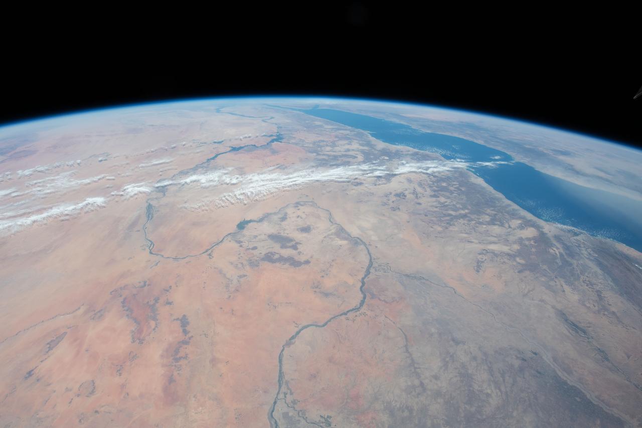
iss073e0768775 (Sept. 26, 2025) --- The Nile River (top) winds through Egypt, which is separated from Saudi Arabia by the Red Sea. The Red Sea branches into two gulfs: the Gulf of Suez, which leads to the Suez Canal—a strategic and economically vital waterway—and the Gulf of Aqaba. The International Space Station was orbiting 257 miles above the Middle East when this photograph was taken.
ASTER succeeded in acquiring this image at night, which is something Visible/Near Infrared VNIR) and Shortwave Infrared (SWIR) sensors cannot do. The scene covers the Red Sea coastline to an inland area of Ethiopia. White pixels represent areas with higher temperature material on the surface, while dark pixels indicate lower temperatures. This image shows ASTER's ability as a highly sensitive, temperature-discerning instrument and the first spaceborne TIR multi-band sensor in history. The size of image: 60 km x 60 km approx., ground resolution 90 m x 90 m approximately. http://photojournal.jpl.nasa.gov/catalog/PIA02452

In December, 2011, NASA Terra spacecraft captured this image of a new volcanic island forming in the Red Sea. This region is part of the Red Sea Rift where the African and Arabian tectonic plates are pulling apart.
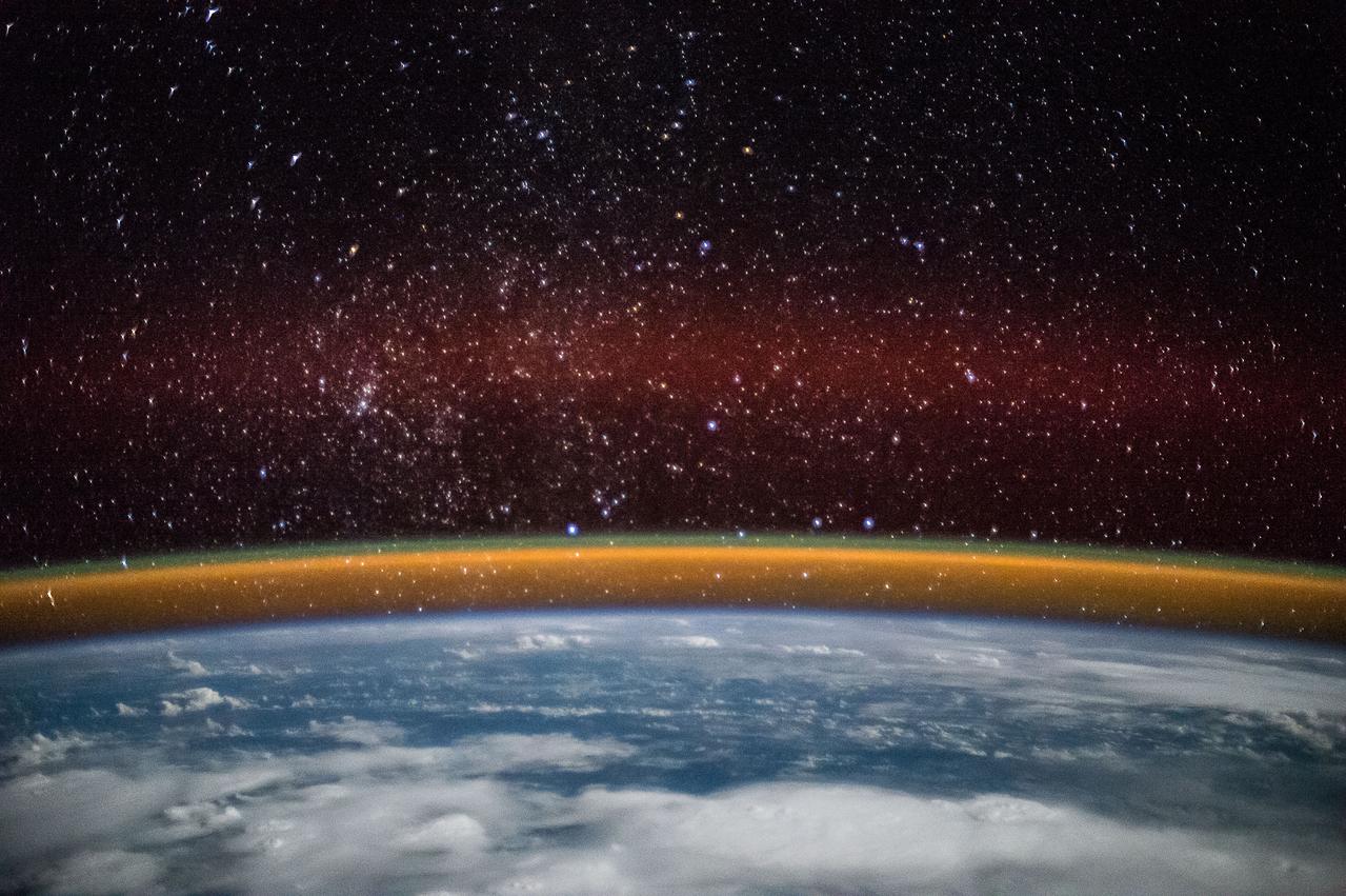
iss073e0824860 (Sept. 14, 2025) --- A red-yellow airglow blankets Earth's horizon above the tranquil, moonlit Philippine Sea in this photograph taken from the International Space Station at approximately 1:49 a.m. local time while orbiting 261 miles above Earth. This type of airglow is caused by chemical reactions in the upper atmosphere, often involving oxygen and hydroxyl molecules, and is typically visible in long-exposure imagery taken from orbit.
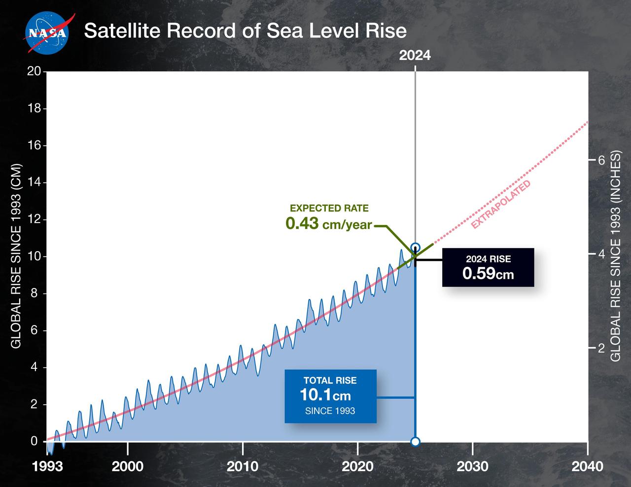
This graph shows the rise in global mean sea level from 1993 to 2024 based on data from a series of five international satellites. The solid red line indicates the trajectory of this increase, which has more than doubled over the three decades. The dotted red line projects future sea level rise. Global sea level rose faster than expected in 2024 due mostly to ocean water expanding as it warms, or thermal expansion. According to a NASA-led analysis, last year's rate of rise was 0.23 inches (0.59 centimeters) per year, compared to the expected rate of 0.17 inches (0.43 centimeters) per year. In recent years, about two-thirds of sea level rise was due to the addition of water from land into the ocean by melting ice sheets and glaciers. About a third came from thermal expansion of seawater. But in 2024, those contributions flipped, with two-thirds of sea level rise coming from thermal expansion. This NASA-led analysis is based on a sea level dataset featuring more than 30 years of satellite observations, starting with the U.S.-French TOPEX/Poseidon mission, which launched in 1992. The Sentinel-6 Michael Freilich mission, which launched in November 2020, is the latest in the series of satellites that have contributed to this sea level record. https://photojournal.jpl.nasa.gov/catalog/PIA26189

Over the past 30 years, global average sea level has risen a total of 3.6 inches (9.1 centimeters), as indicated in this graphic, which is based on sea level measurements (in blue) from five successive satellites starting with the U.S.-French TOPEX/Poseidon mission in 1993. The solid red line shows the trajectory of sea level rise from 1993 to 2022, while the dotted red line shows the increase sea level into the future. Researchers can take the solid red line and calculate the rate of sea level rise, which was 0.08 inches (0.20 centimeters) per year in 1993 and doubled to 0.17 inches (0.44 centimeters) per year by 2022. The dotted red line shows that by 2040, sea levels may rise by an additional 3.66 inches (9.3 cm) above 2022 levels. The trajectory shown in the solid and dotted red line is based on work by the NASA Sea Level Change Team and the Ocean Surface Topography Science Team. https://photojournal.jpl.nasa.gov/catalog/PIA25775
Oblique Earth Observation taken by the Apollo 9 crew. View is the United Arab Republic,the Nile River,The Red Sea and the Aswan Dam. Film magazine was E,film type was SO-368 Ektachrome with 0.460 - 0.710 micrometers film / filter transmittance response and haze filter,80mm lens. Latitude was 19.38 N by Longitude 30.24 E, Overlap was 50%, Altitude was 97 nautical miles and cloud cover was 5%.
NASA Terra spacecraft acquired this image of St. Anthony, the world oldest Christian monastery, settled in the remote mountainous area of eastern Egypt near the Red Sea.
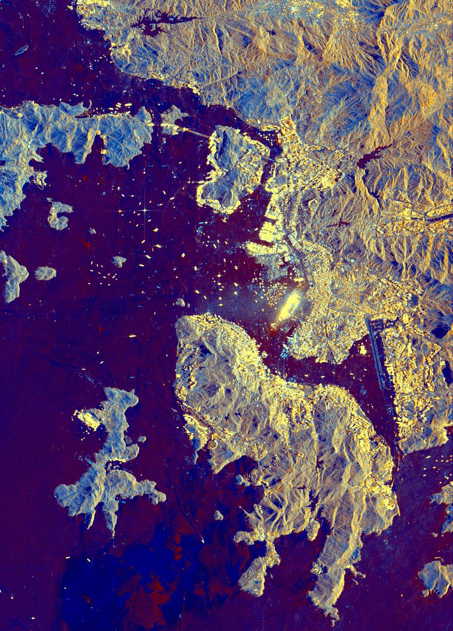
This spaceborne radar image shows part of the British territory of Hong Kong, adjacent to mainland China. The South China Sea is shown in dark blue and red on the image.
The area known as the Afar Triangle is located at the northern end of the East Africa Rift, where it approaches the southeastern end of the Red Sea and the southwestern end of the Gulf of Aden.
How precisely do the size of the aerosol particles comprising the dust that obscured the Red Sea on July 26, 2005? This image is from NASA Terra spacecraft.
In the Arabian Sea, sunlight and nutrients has fueled a startling occurrence of colorful phytoplankton and bacterial assemblages, which is captured in these natural color images from NASA Terra spacecraft October 2, 2004.
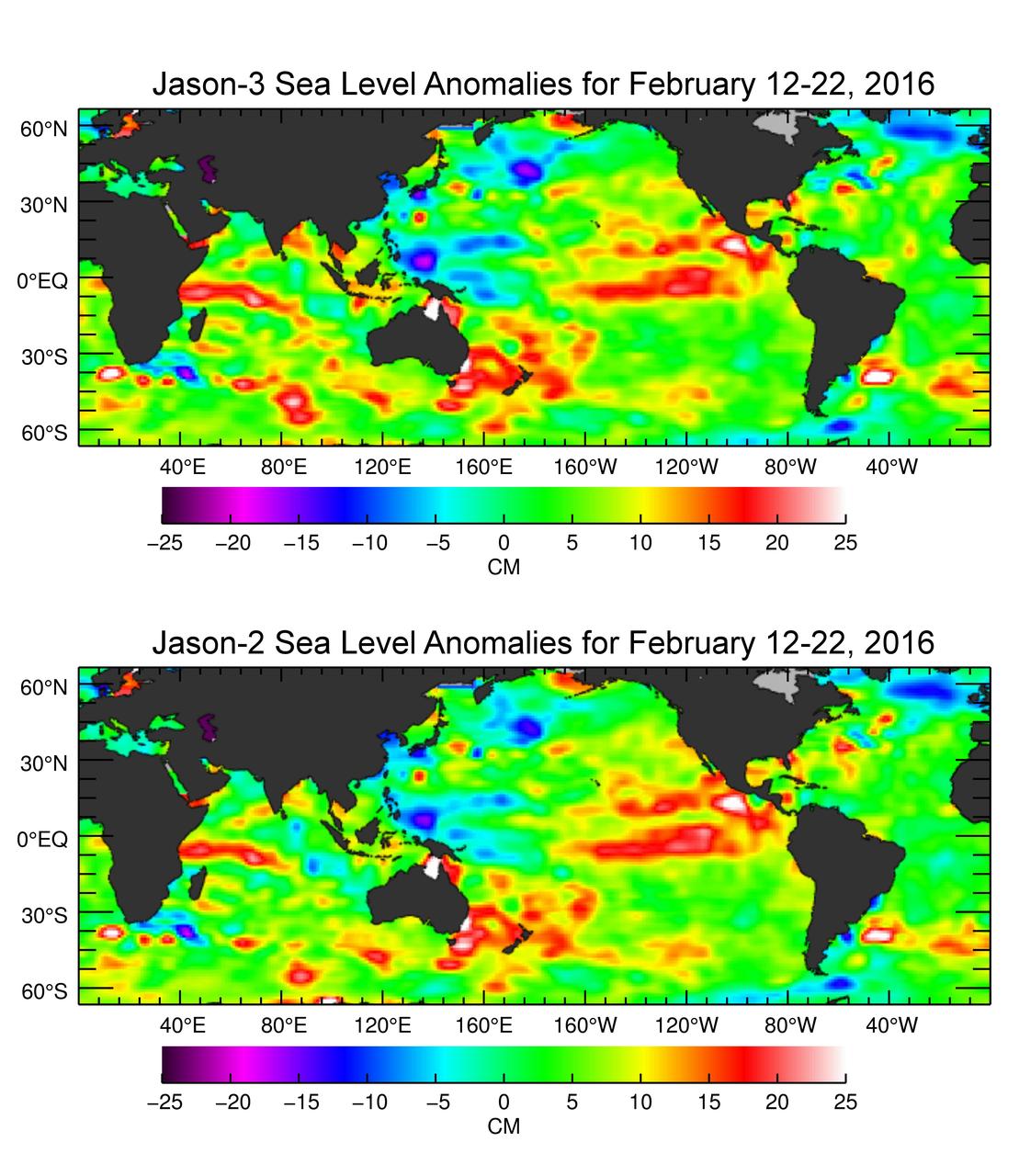
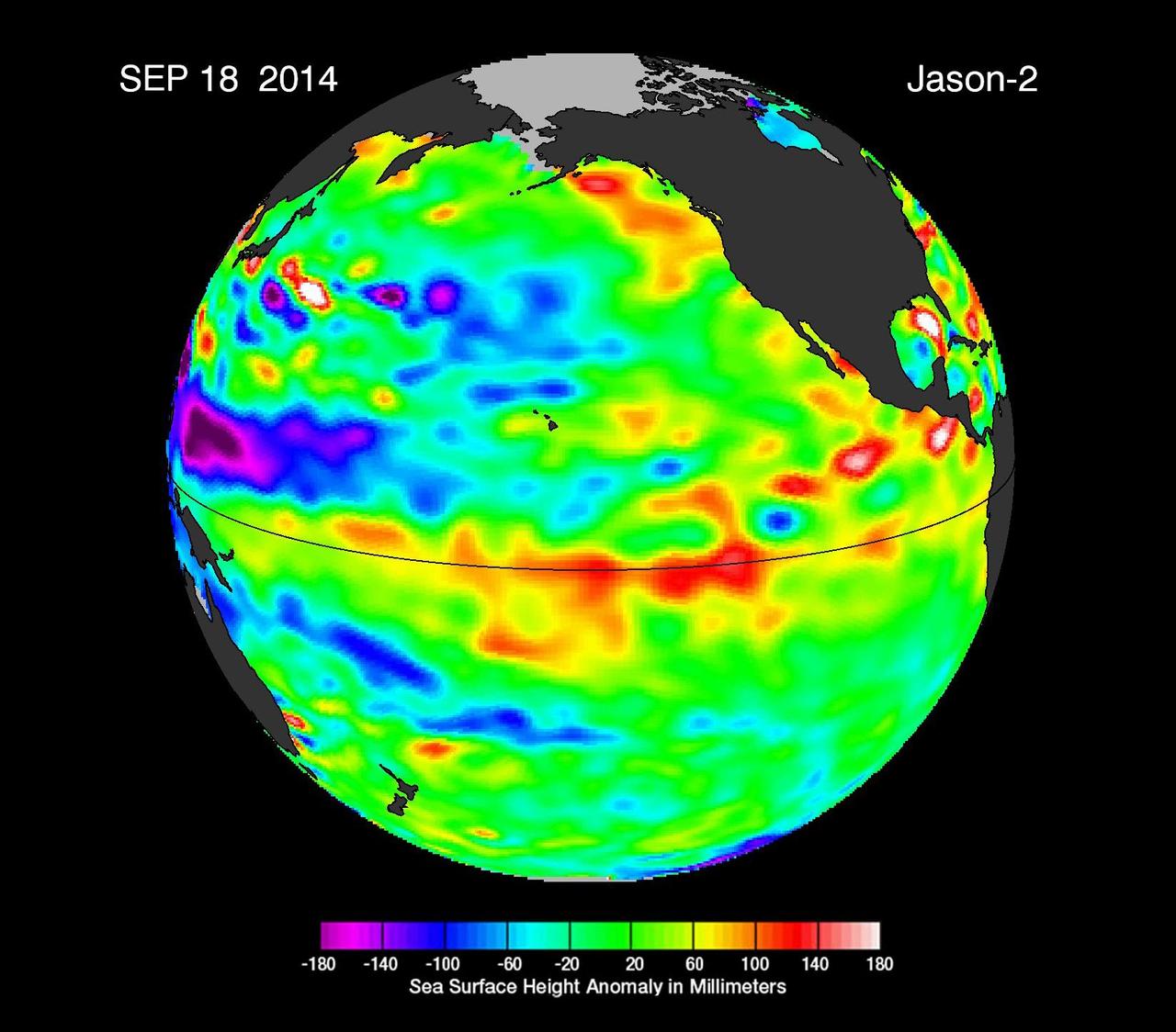
The U.S./European Jason-3 satellite has produced its first map of sea surface height, which corresponds well to data from its predecessor, Jason-2. Higher-than-normal sea levels are red; lower-than-normal sea levels are blue. El Niño is visible as the red blob in the eastern equatorial Pacific. Extending the timeline of ocean surface topography measurements begun by the Topex/Poseidon and Jason 1 and 2 satellites, Jason 3 will make highly detailed measurements of sea-level on Earth to gain insight into ocean circulation and climate change. http://photojournal.jpl.nasa.gov/catalog/PIA20532
iss069e004371 (April 19, 2023) --- The Yemeni cities of Little Aden and Aden, on the coast of the Arabian Sea near the Red Sea, were pictured by Expedition 69 Flight Engineer and UAE (United Arab Emirates) astronaut Sultan Alneyadi as the International Space Station orbited 257 miles above.
AS17-148-22718 (7-19 Dec. 1972) --- This excellent view of Saudi Arabia and the north eastern portion of the African continent was photographed by the Apollo 17 astronauts with a hand-held camera on their trans-lunar coast toward man's last lunar visit. Egypt, Sudan, Ethiopia are some of the African nations are visible. Iran, Iraq, Jordan are not so clearly visible because of cloud cover and their particular location in the picture. India is dimly visible at right of frame. The Red Sea is seen entirely in this one single frame, a rare occurrence in Apollo photography or any photography taken from manned spacecraft. The Gulf of Suez, the Dead Sea, Gulf of Aden, Persian Gulf and Gulf of Oman are also visible. This frame is one of 169 frames on film magazine NN carried aboard Apollo 17, all of which are SO368 (color) film. A 250mm lens on a 70mm Hasselblad camera recorded the image, one of 92 taken during the trans-lunar coast. Note AS17-148-22727 (also magazine NN) for an excellent full Earth picture showing the entire African continent.

This graph shows the rise in global mean sea level from 1993 to 2023 based on data from a series of five international satellites. The solid red line indicates the trajectory of this increase, which has more than doubled over the three decades. The dotted red line projects future sea level rise. The relatively large jump in sea level from 2022 to 2023, a rise of about 0.3 inches (0.76 centimeters), is due mostly to a warming climate and the development of a strong El Niño. The 2022-2023 rise is equivalent to draining a quarter of Lake Superior into the ocean over the course of a year. This NASA-led analysis is based on a sea level data set featuring more than 30 years of satellite observations, starting with the U.S.-French TOPEX/Poseidon mission, which launched in 1992. The Sentinel-6 Michael Freilich mission, which launched in November 2020, is the latest in the series of satellites that have contributed to this sea level record. https://photojournal.jpl.nasa.gov/catalog/PIA26183
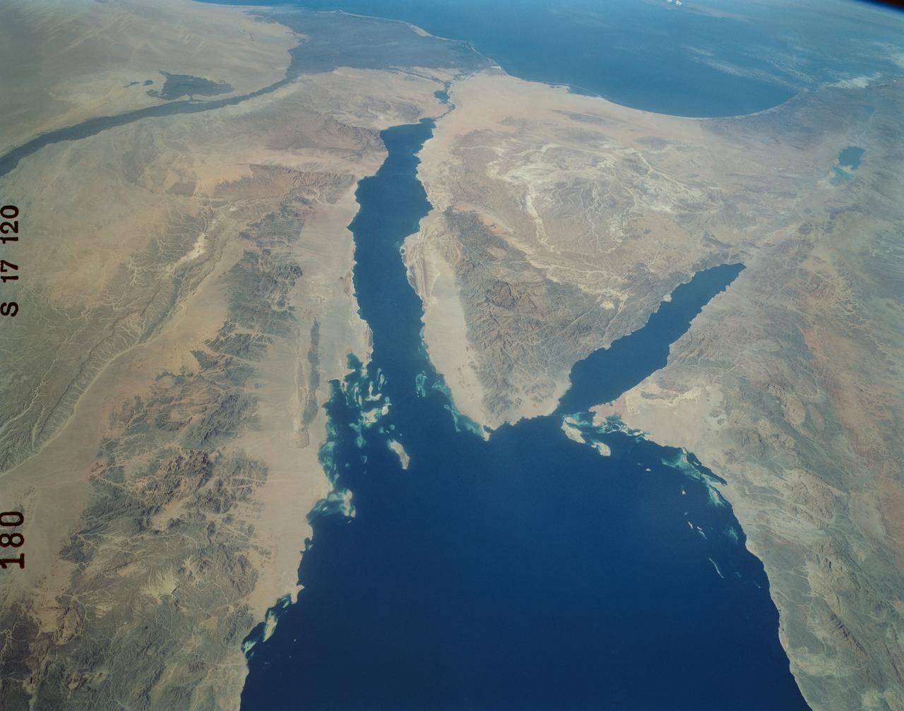
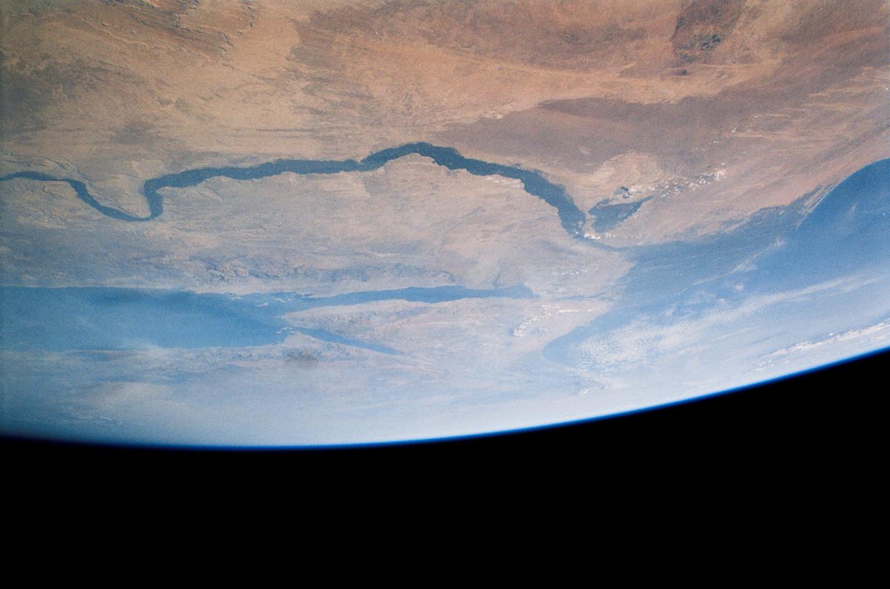
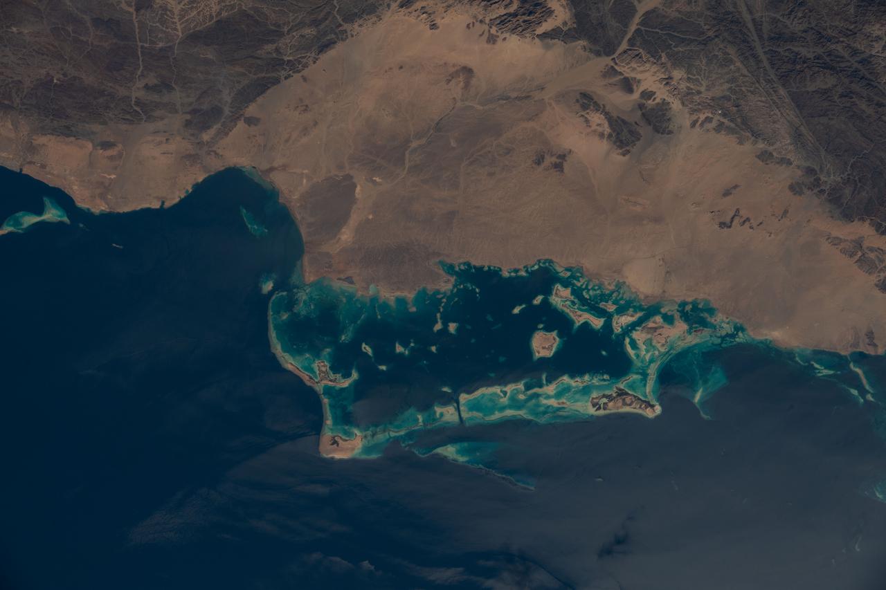
This image from NASA Terra satellite in August, 2000, shows the northern tip of the Red Sea, the Gulf of Suez and the Gulf of Aqaba frame the sandy deserts and spectacular mountains of the Sinai Peninsula.
This image from NASA European Jason-2 satellite shows Kelvin waves of high sea level red/yellow crossing the Pacific Ocean at the equator. The waves can be related to El Niño events.
STS112-702-002 (7-18 October 2002) --- Egypt's triangular Sinai Peninsula lies in the center of this view, photographed from the Space Shuttle Atlantis, with the dark greens of the Nile delta lower right. In this southwesterly view, the Red Sea, with its characteristic parallel coastlines, stretches toward the top. At the bottom of the image, the Suez Canal appears as an irregular line joining the Red Sea to the Mediterranean Sea (lower left). The Dead Sea in central Israel, with its light blue salt ponds at the south end, appears on the left margin.
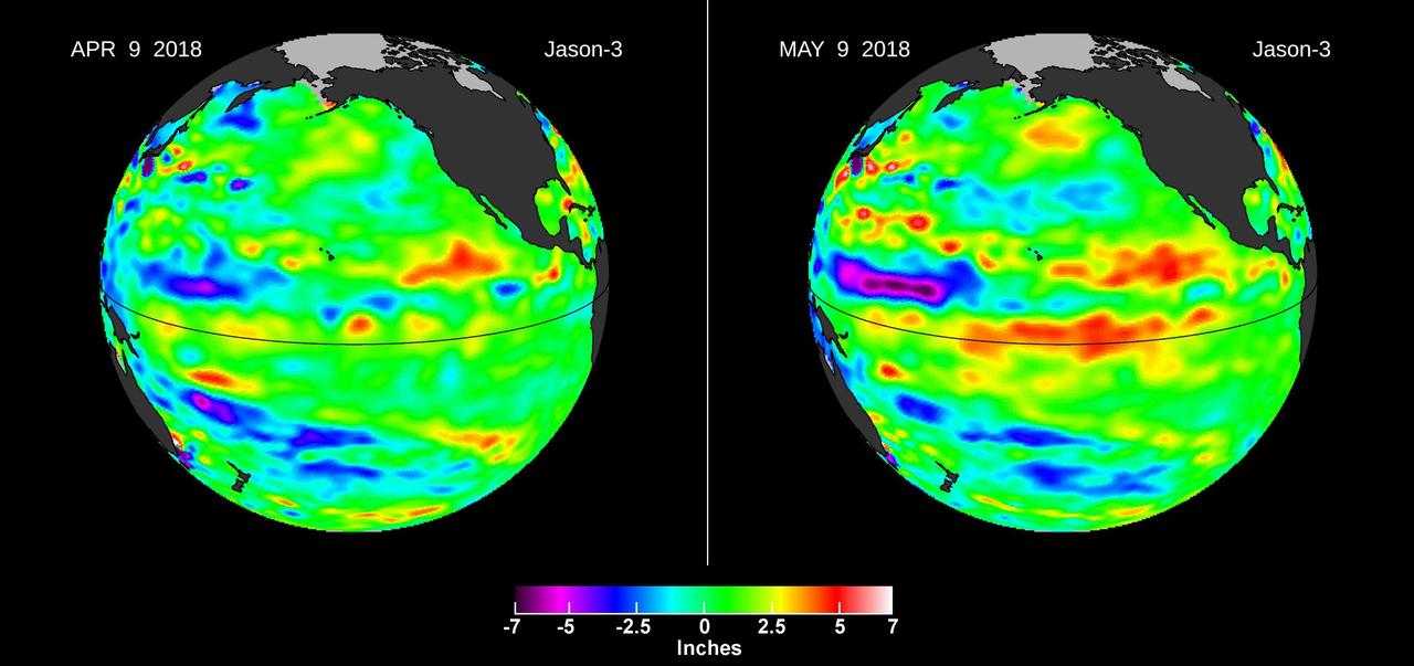
Images from the U.S./European Jason-3 satellite show sea surface height with respect to the seasonal cycle and the long-term trend. Blue/magenta colors indicate lower-than-normal sea levels, while yellow/red colors indicate higher-than-normal sea levels. The April 9, 2018 image (left panel) shows most of the ocean at neutral heights (green). A month later (right panel), a red patch is visible along the equator in the Central Pacific. The red area is a downwelling Kelvin wave, traveling eastward along the equator. https://photojournal.jpl.nasa.gov/catalog/PIA22473
iss064e053173 (April 4, 2021) --- The Nile River, The Red Sea, The Gulf of Oman, The Gulf of Aqaba, and The Mediterranean Sea are pictured in the Middle East from the International Space Station as it orbited 263 miles above Egypt.
iss062e069299 (March 1, 2020) --- This image taken from the International Space Station as it orbited 263 miles above Sudan shows the Nile River winding northward next to the Red Sea toward the Mediterranean Sea.
iss059e099177 (June 10, 2019) --- The Nile River, Red Sea and Mediterranean Sea are contrasted by the desert nations of Egypt, Saudi Arabia, Israel and Jordan as the International Space Station orbits 254 miles above Africa.
iss067e178289 (July 8, 2022) --- The Nile River is pictured flowing toward the Mediterranean Sea in this picture from the International Space Station as it orbited 261 miles above the African nation of Sudan. At right, is the Red Sea.
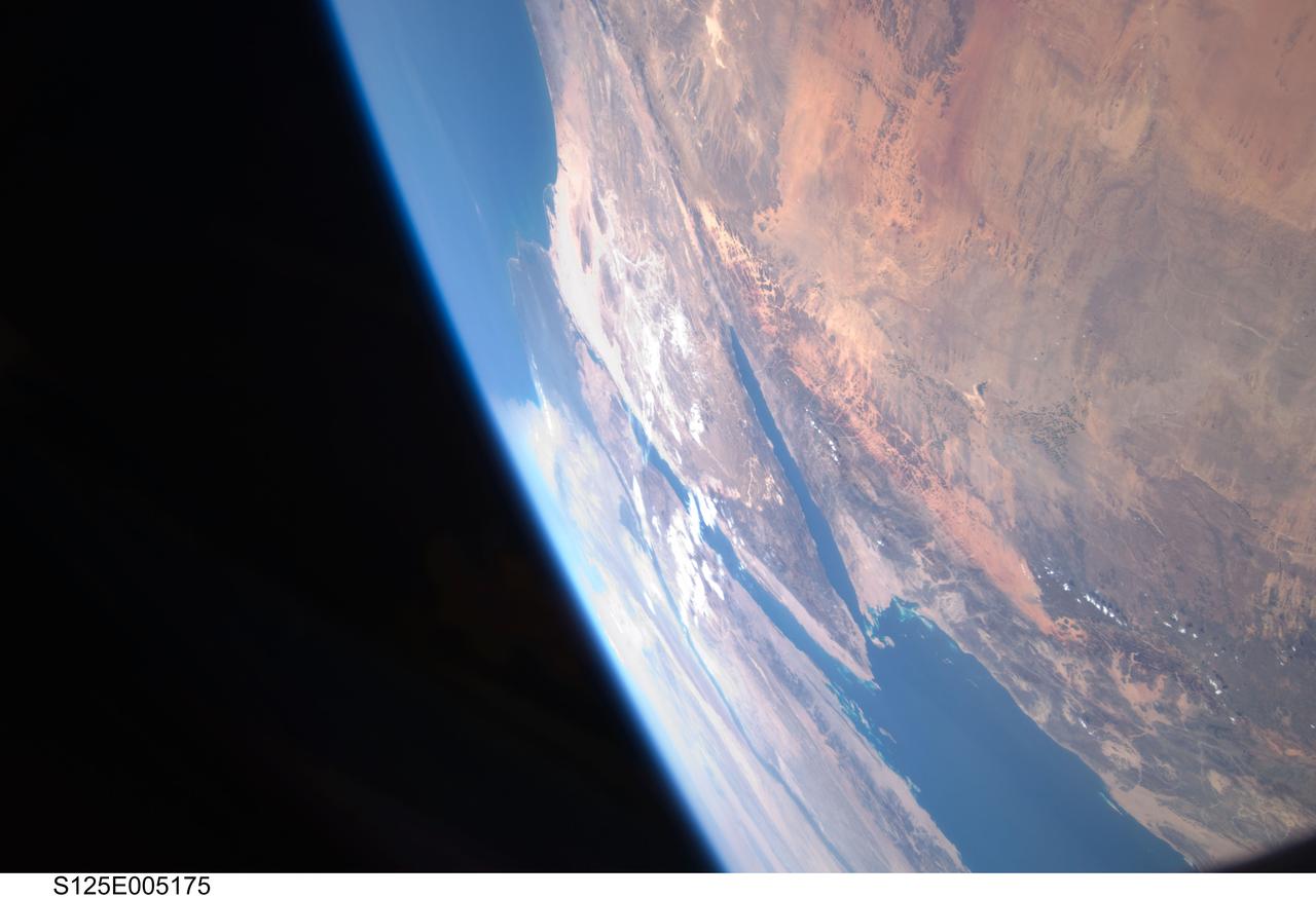
S125-E-005175 (12 May 2009) --- Among the first group of still images downlinked by the STS-125 crewmembers onboard the Space Shuttle Atlantis was this high oblique scene looking toward the Red Sea, Sinai Peninsula and the Mediterranean Sea. Saudi Arabia is in the foreground and Egypt?s Nile River and its delta can be seen (left) toward the horizon. Israel and Jordan can be seen near the top edge of the frame. The Gulf of Suez and the Gulf of Aqaba (near frame center) extend from the Red Sea toward the Mediterranean Sea.
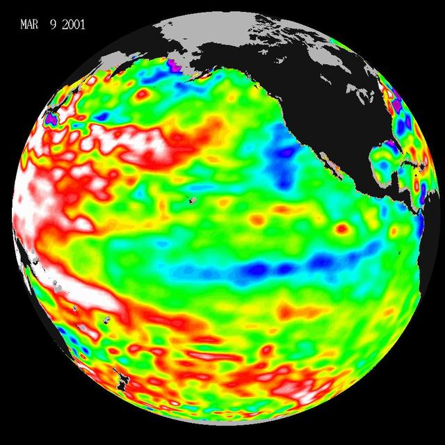
Data taken during a 10-day collection cycle ending March 9, 2001, show that above-normal sea-surface heights and warmer ocean temp. red and white areas still blanket the far-western tropical Pacific and much of the north and south mid-Pacific.
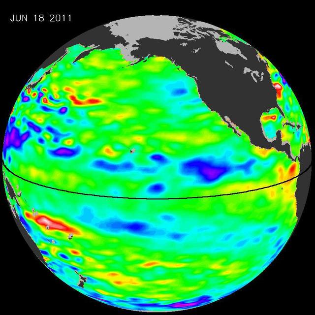
The latest image of Pacific Ocean sea surface heights from the NASA OSTIM/Jason-2 oceanography satellite, on June 11, 2010, shows that Pacific has switched from warm red to cold blue during the last few months.
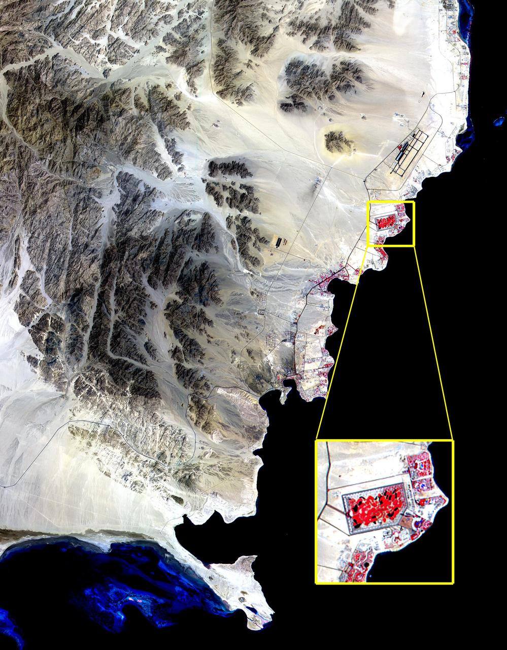
The Red Sea golf resort in Sharm El Sheik, Egypt, where President Clinton met with Israeli Prime Minister Ehud Barak and Palestinian Authority President Yasser Arafat, stands out against the desert landscape in this image acquired on August 25, 2000. This image of the southern tip of the Sinai Peninsula shows an area about 30 by 40 kilometers (19 by 25 miles) in the visible and near infrared wavelength region. Vegetation appears in red. The blue areas in the water at the top and bottom of the image are coral reefs. The airport is visible just to the north of the golf resort. http://photojournal.jpl.nasa.gov/catalog/PIA02667
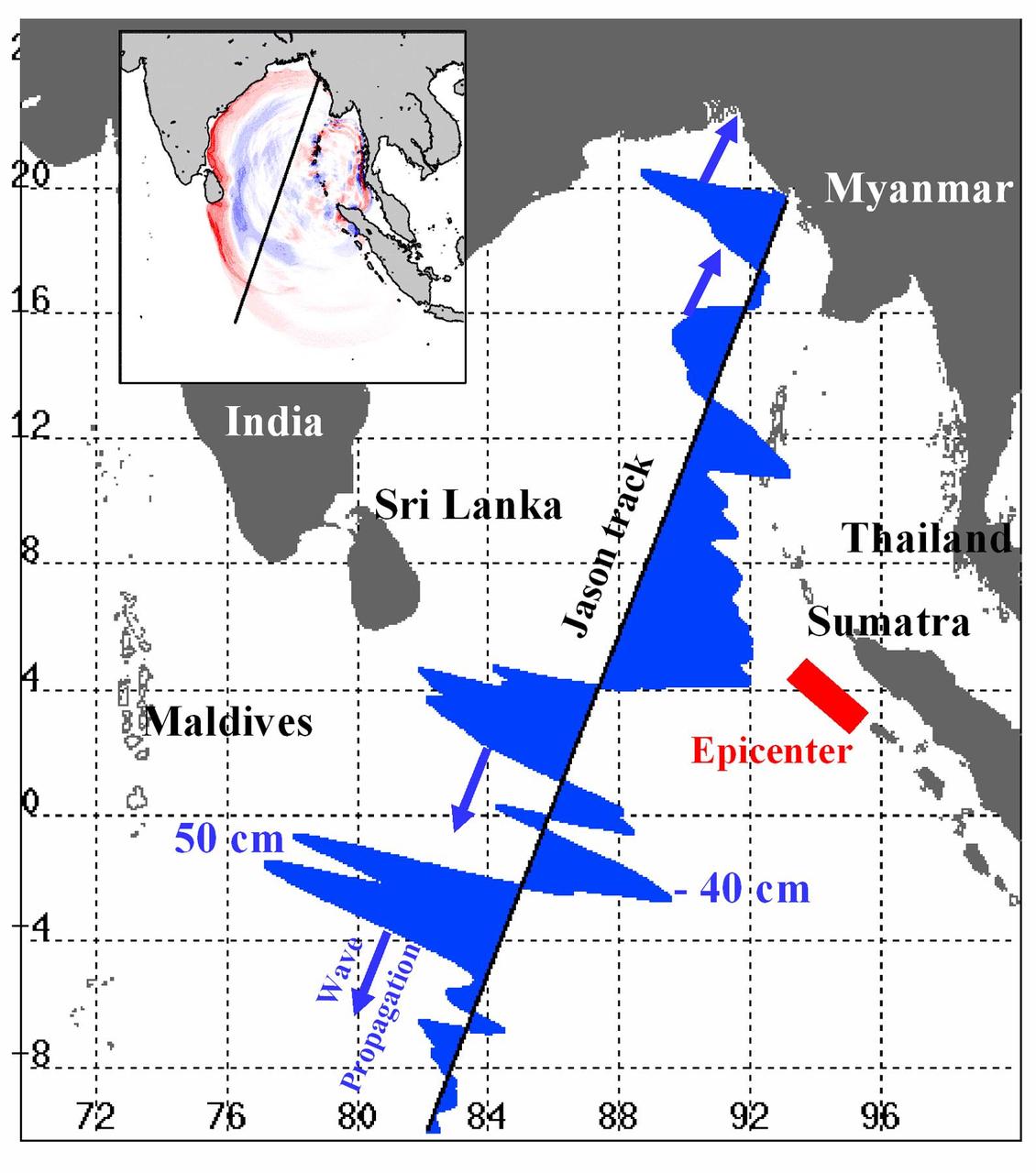
Displayed in blue color is the height of sea surface (shown in blue) measured by the Jason satellite two hours after the initial magnitude 9 earthquake hit the region (shown in red) southwest of Sumatra on December 26, 2004. The data were taken by a radar altimeter onboard the satellite along a track traversing the Indian Ocean when the tsunami waves had just filled the entire Bay of Bengal (see the model simulation inset image). The data shown are the changes of sea surface height from previous observations made along the same track 20-30 days before the earthquake, reflecting the signals of the tsunami waves. The maximum height of the leading wave crest was about 50 cm (or 1.6 ft), followed by a trough of sea surface depression of 40 cm. The directions of wave propagation along the satellite track are shown by the blue arrows. http://photojournal.jpl.nasa.gov/catalog/PIA07219
S125-E-005173 (12 May 2009) --- Among the first group of still images downlinked by the STS-125 crewmembers onboard the Space Shuttle Atlantis was this high oblique scene looking toward the Sinai Peninsula and the Mediterranean Sea. The Red Sea is just out of frame at bottom right. Saudi Arabia is in the right foreground and Egypt?s Nile River and its delta can be seen (lower left) toward the horizon. Jordan and a small portion of Israel can be seen near the top of the frame. The Gulf of Suez and the Gulf of Aqaba extend from the Red Sea toward the Mediterranean.
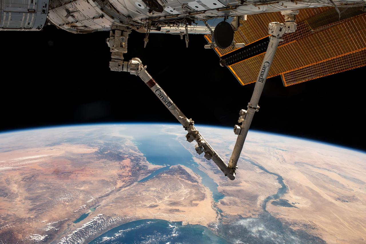
iss067e286504 (Aug. 21, 2022) --- The Canadarm2 robotic arm extends from the top right foreground, with the Nile Delta and the Red Sea, situated in the Arabian Peninsula, pictured from the International Space Station as it orbited 257 miles above the Mediterranean Sea.
STS121-334-026 (4-17 July 2006) --- This photo, featuring an easterly view of the Nile River, the Nile River Delta, Sinai Peninsula, the Suez Canal, Red Sea and part of the Mediterranean Sea, was taken by one of the STS-121 crewmembers aboard the Space Shuttle Discovery. Cairo, Egypt, can be seen at far right.
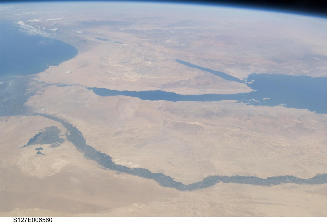
S127-E-006560 (17 July 2009) -- The Nile River and its delta in Egypt and the Sinai Peninsula and part of the Mediterranean Sea and Red Sea are just a few of the geographic features recognizable in this photograph, taken from an aft window on the Earth-orbiting Space Shuttle Endeavour.

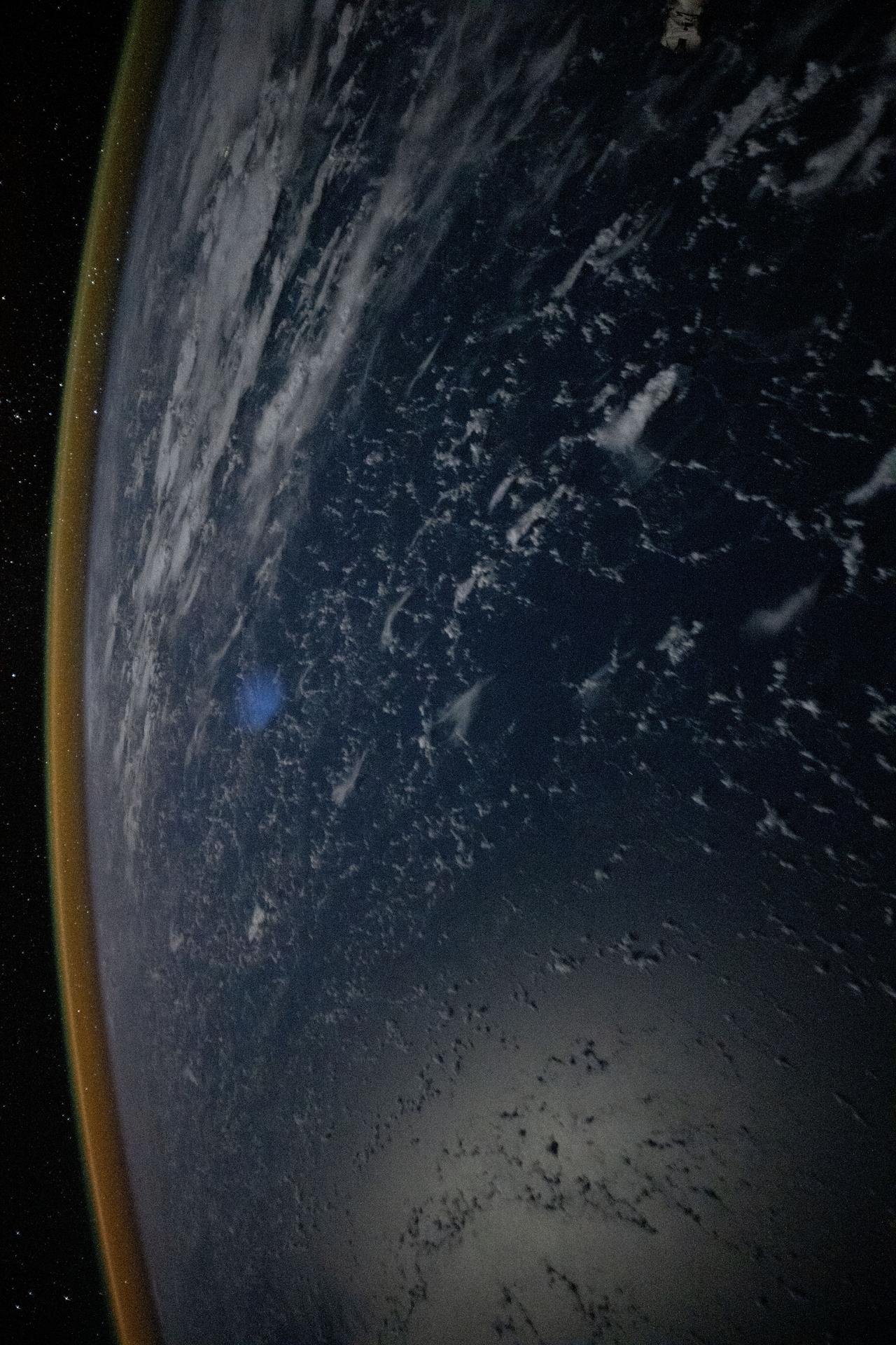
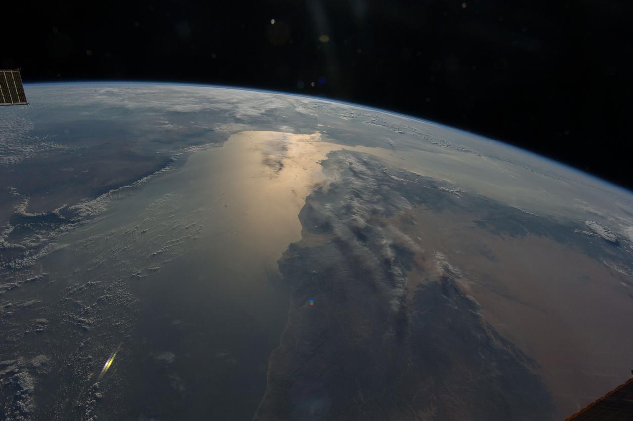
iss069e031369 (July 13, 2023) -- White and pink clouds cover Earth as the International Space Station orbited 259 miles above the coast of the Red Sea, the northernmost tropical sea in the world. A roll-out solar array is displayed in the bottom right corner of the image.
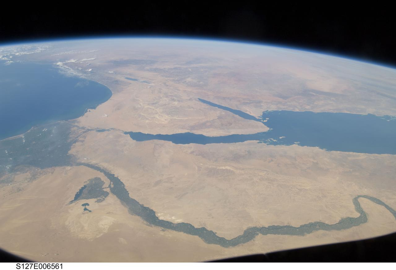
S127-E-006561 (17 July 2009) -- The Nile River and its delta in Egypt and the Sinai Peninsula and part of the Mediterranean Sea and Red Sea are just a few of the geographic features recognizable in this photograph, taken from an aft window on the Earth-orbiting Space Shuttle Endeavour.
iss070e007599 (Oct. 20, 2023) --- The Canadarm2 robotic arm extends from the International Space Station as it orbited 261 miles above Turkey. Below, the Sinai Peninsula, the Red Sea, and the Nile River Delta are pictured leading toward the Mediterranean Sea at bottom.
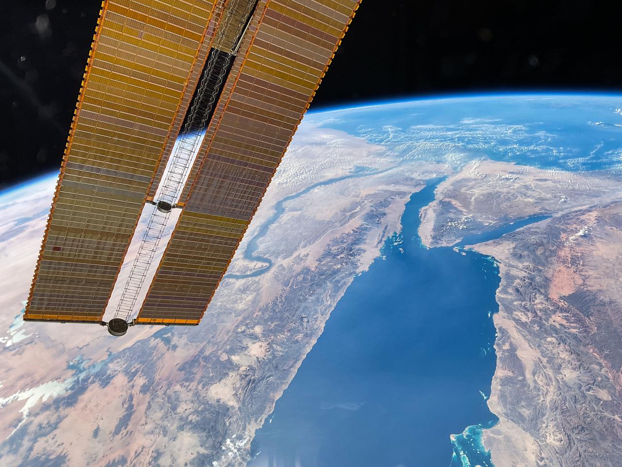
iss069e090728 (Sept. 20, 2023) --- The Nile River and the Red Sea lead to the Mediterranean Sea and are pictured from the International Space Station as it orbited 258 miles above the Arabian Peninsula. A pair of the space station's main solar arrays drapes across the left foreground.
iss071e207494 (June 24, 2024) -- Soaring 263 miles above Egypt, NASA astronaut Butch Wilmore captured this photo from the International Space Station. To the left of the image is the Mediterranean Sea. Snaking from it is the Nile River, and at the very top of the image is the Red Sea.
iss071e405499 (July 26, 2024) -- Flowing into the Mediterranean Sea, the Nile River is pictured from the International Space Station as it orbited 257 miles above Egypt. The Gulfs of Suez and Aqaba, feeding into the Red Sea, can also be seen in this photo, contrasting against the surrounding tan and orange terrain.

STS083-709-030 (4-8 April 1997) --- Panorama over the Nile River, Sinai Peninsula and the Red Sea. Looking past the Orbiter's tail, this view extends from central Egypt eastward to Saudi Arabia on the horizon. Two major water systems, seen in this view, the Nile River and the Red Sea are used for world commerce and transportation in this region. The Nile is flanked immediately by agriculture then beyond by desert. This emphasizes the importance of the river waters to sustain a thriving local population. The Nile River delta is north under the clouds on the upper left-hand corner of the photo. Geologically, the Red Sea is a spreading center between the Arabian and the African Plates, and will continue to widen slowly over a long period of time.
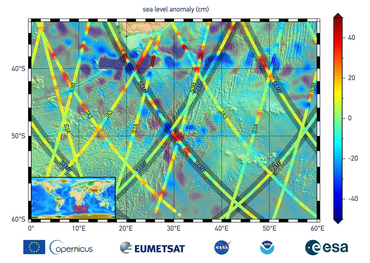
This graphic, released on Dec. 10, 2020, shows the first sea level measurements taken by Sentinel-6 Michael Freilich (S6MF), which launched Nov. 21, 2020. It focuses on the ocean off the southern tip of Africa, where red colors indicate higher sea level relative to blue areas, which are lower. Also included are sea surface height measurements from three other satellites for comparison: Jason-3 (JA3), Sentinel-3A (S3A), and Sentinel-3B (S3B). https://photojournal.jpl.nasa.gov/catalog/PIA24135
STS003-17-806 (22-30 March 1982) --- A 70mm out-the-window view showing Israel, the Dead Sea, Sea of Galilee, Jordan River, Sinai, Jordan, the Red Sea and Egypt (in background). Rested Remote Manipulator System (RMS) arm and part of the aft section of space shuttle Columbia in foreground. Photo credit: NASA

iss071e406275 (July 27, 2024) -- The third quarter moon rises just above Earth's blue horizon as the International Space Station orbited 258 miles above the Red Sea.
iss064e029305 (Feb. 3, 2021) --- This view of the Earth's horizon looks across the Red Sea and the Nile River in Africa as the International Space Station orbited 261 miles above Saudi Arabia.
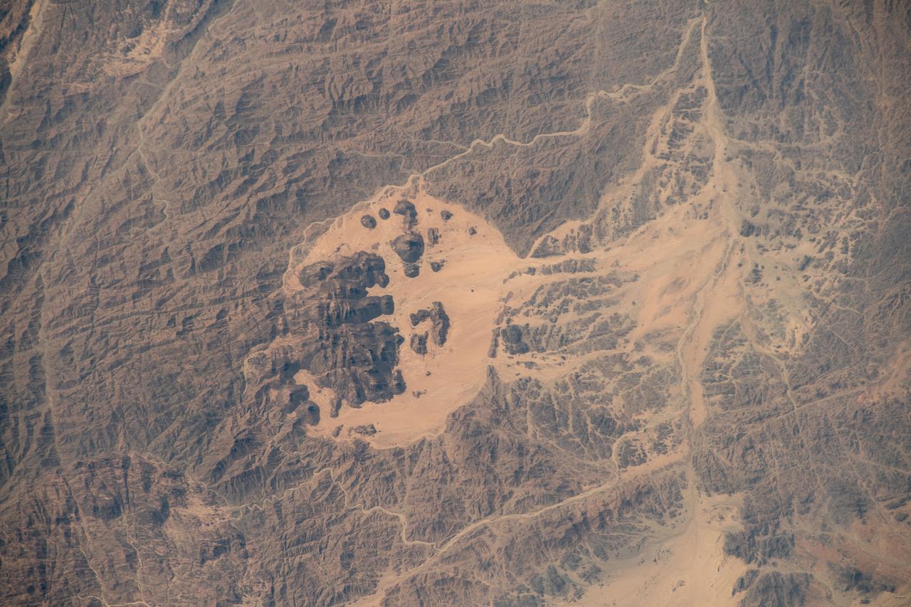
iss067e286537 (Aug. 21, 2022) --- This portion of the Hejaz region on the coast of the Red Sea, just northwest of Medina, Saudi Arabia, is pictured from the International Space Station as it orbited 257 miles above.

iss066e145575 (Feb. 15, 2022) --- The Full Moon is pictured above the Red Sea as the International Space Station orbited 257 miles above the Nile River in the African nation of Sudan.
iss066e091657 (Nov. 30, 2021) --- The northwestern coast of Saudi Arabia on the Red Sea is pictured from the International Space Station as it orbited 263 miles above the Middle Eastern nation.
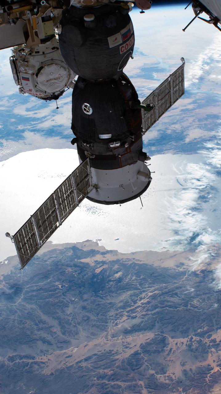
iss066e125409 (Jan. 24, 2022) --- The Soyuz MS-19 crew ship and the Prichal docking module (in the background), with the Red Sea below, are pictured as the International Space Station orbited 258 miles above Saudi Arabia.
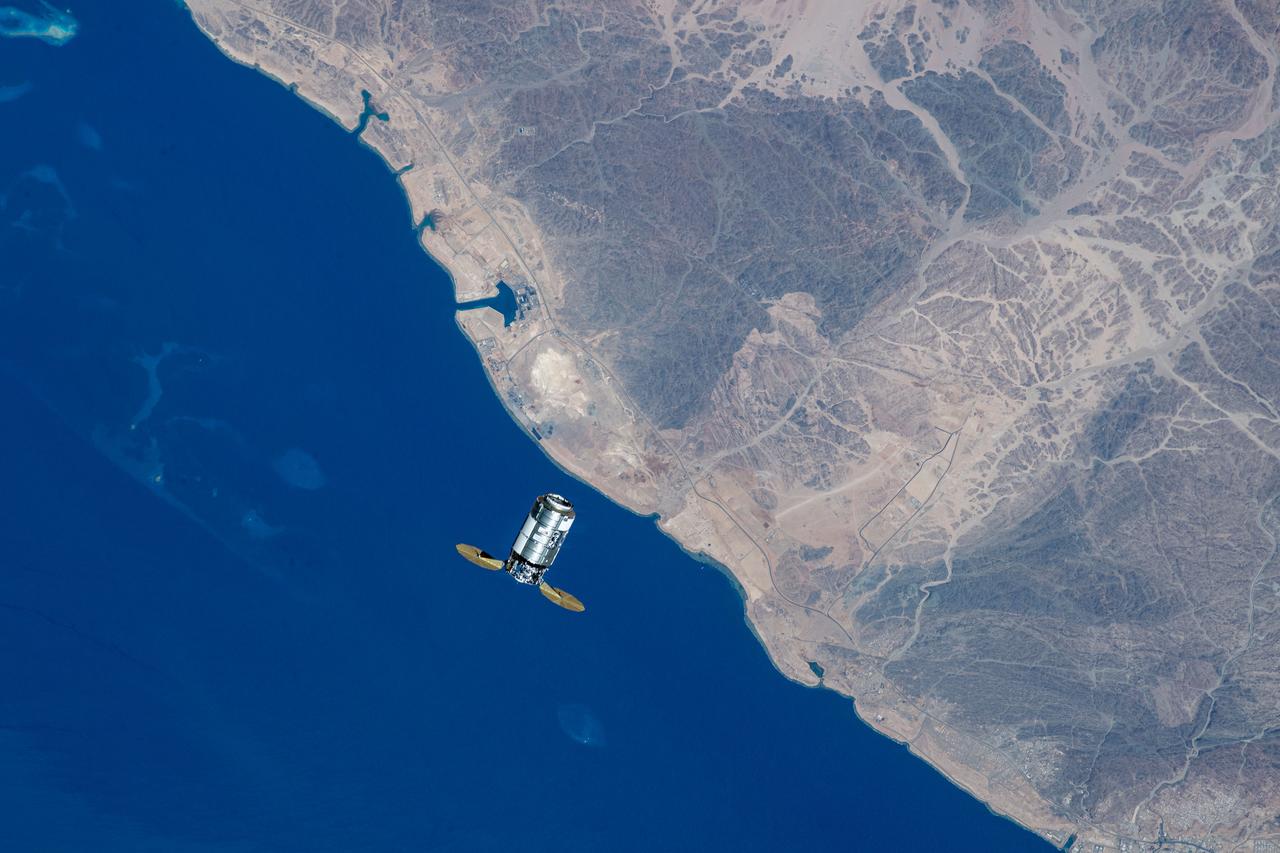
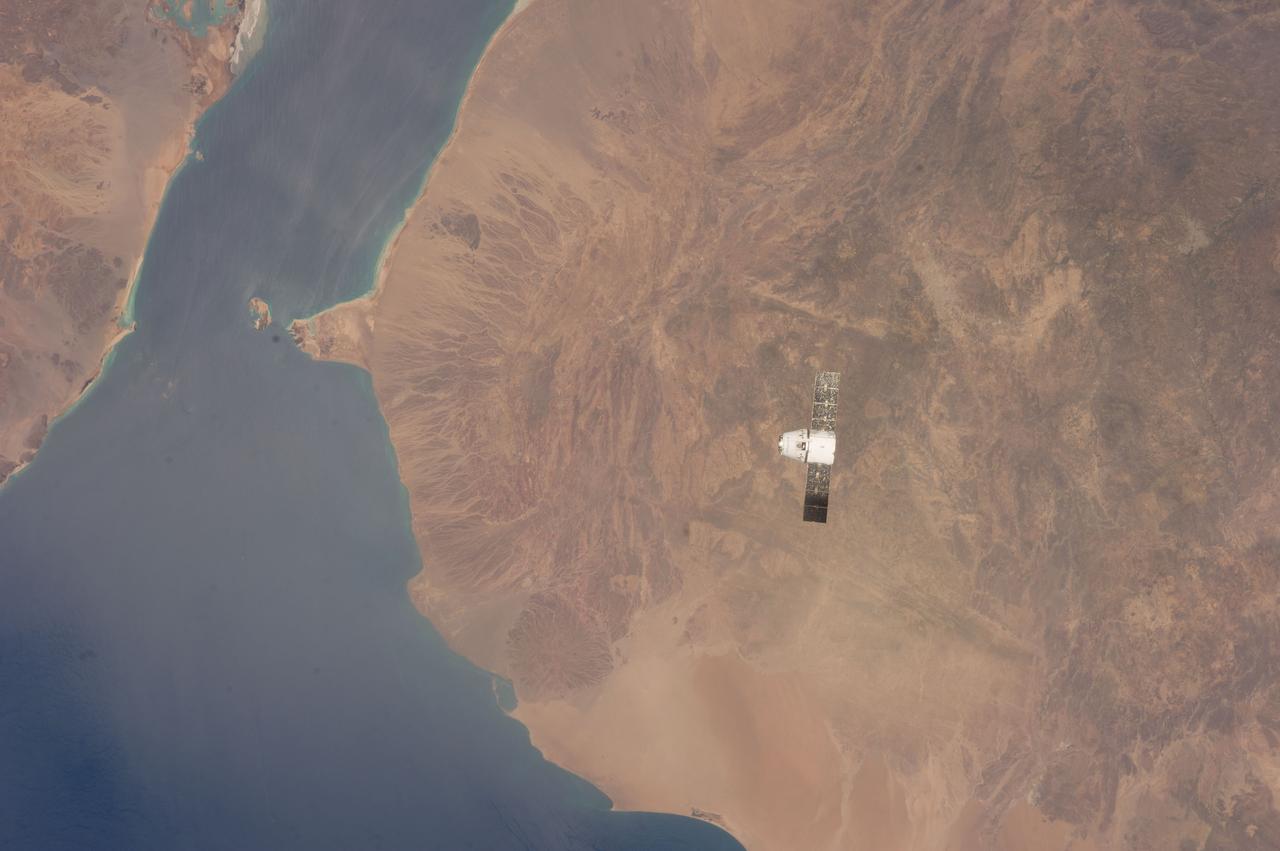
iss069e053861 (Aug. 4, 2023) --- Northrop Grumman's Cygnus cargo craft is pictured from the International Space Station as it approaches while orbiting 261 miles above the coast of the Red Sea in Saudi Arabia.
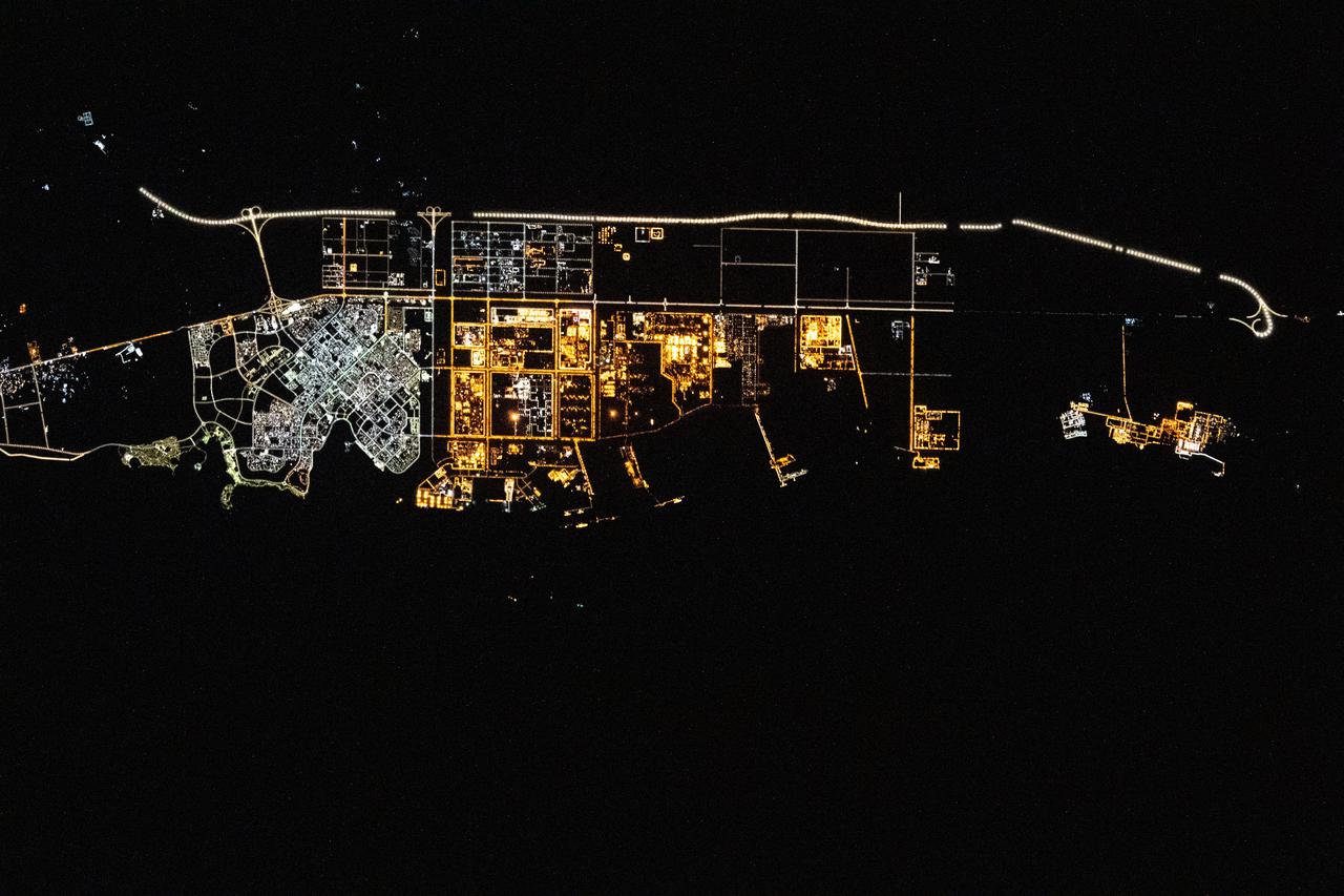
iss066e128404 (Jan. 26, 2022) --- The city lights of Yanbu, a Saudi Arabian port city on the Red Sea coast, are pictured during an orbital nightime pass from the International Space Station as it orbited 260 miles above.
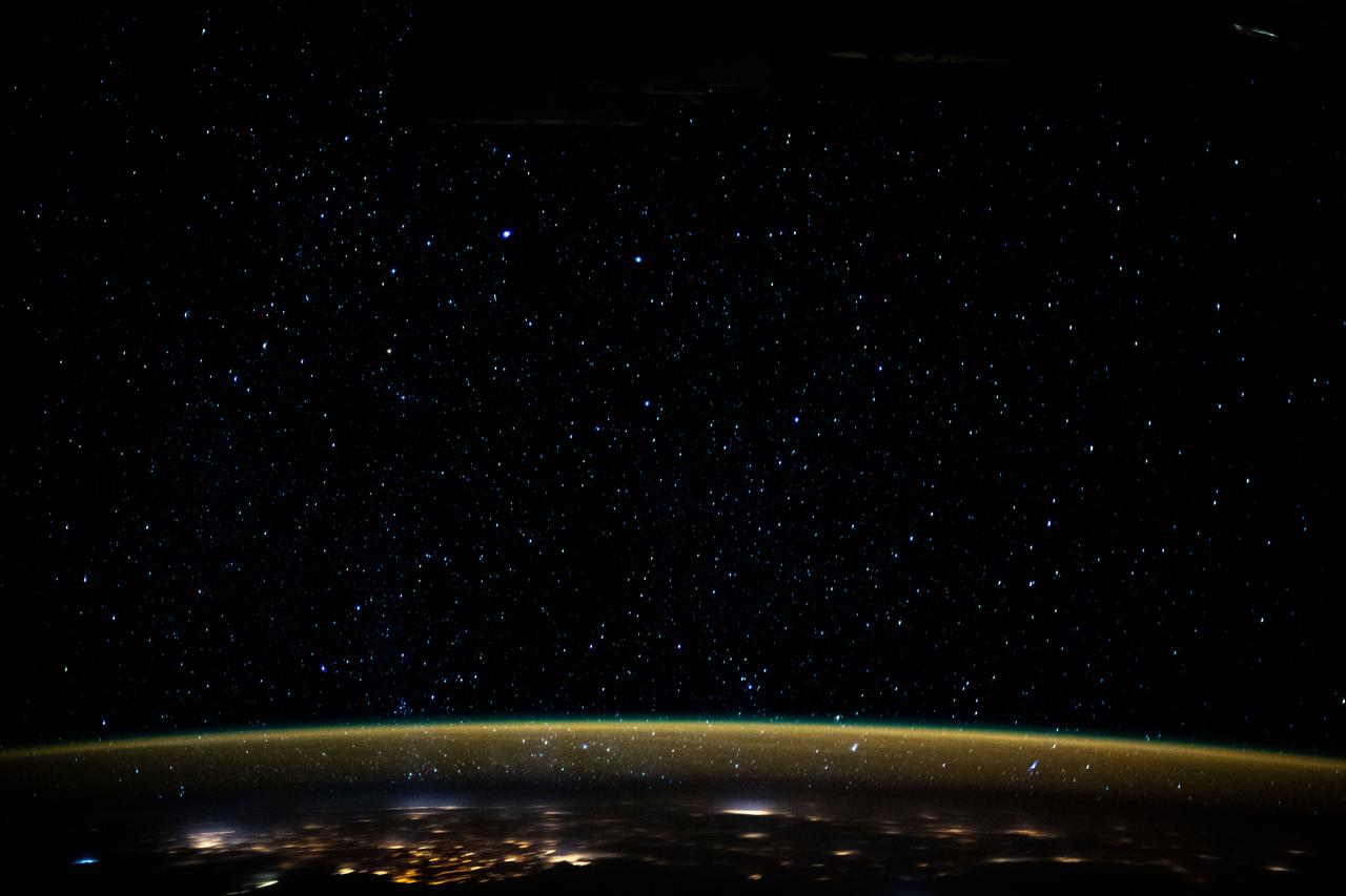
iss061e110433 (Dec. 29, 2019) --- Stars glitter in the night sky above an atmospheric glow that blankets the city lights as the International Space Station orbited 259 miles above the Sudanese/Egyptian border before it crossed the Red Sea.
iss059e078914 (May 29, 2019) --- Storm clouds are seen on the southwestern coast of Yemen as the International Space Station was about to fly 254 miles over the Bab al-Mandab Strait in between the Gulf of Aden and the Red Sea.
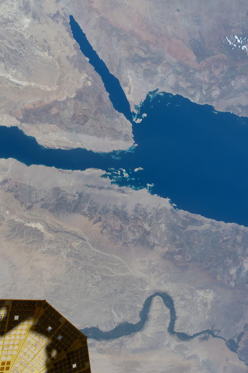
iss071e413541 (Aug. 1, 2024) -- The Gulf of Suez (left) and Gulf of Aqaba (right) flow into the Red Sea as the International Space Station orbited nearly 260 miles above Saudi Arabia.
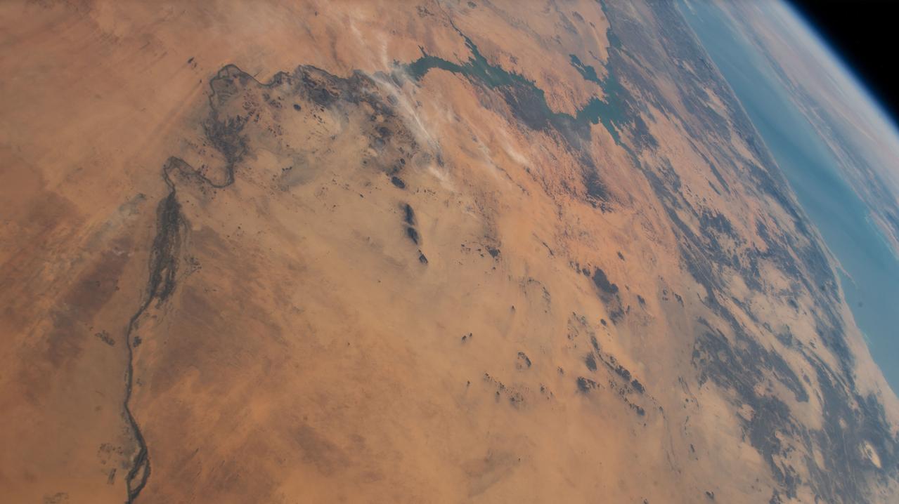
iss070e002272 (Oct. 6, 2023) --- The Jibāl Hawlad mountain range, near the Red Sea, is pictured in the African nation of Sudan as the International Space Station orbited 258 miles above.
iss042e031364 (12/08/2014) ---US Astronaut Terry Virts aboard the International Space Station caught this stunning image of the Red Sea and East Afirca at dusk 8 December 2014.
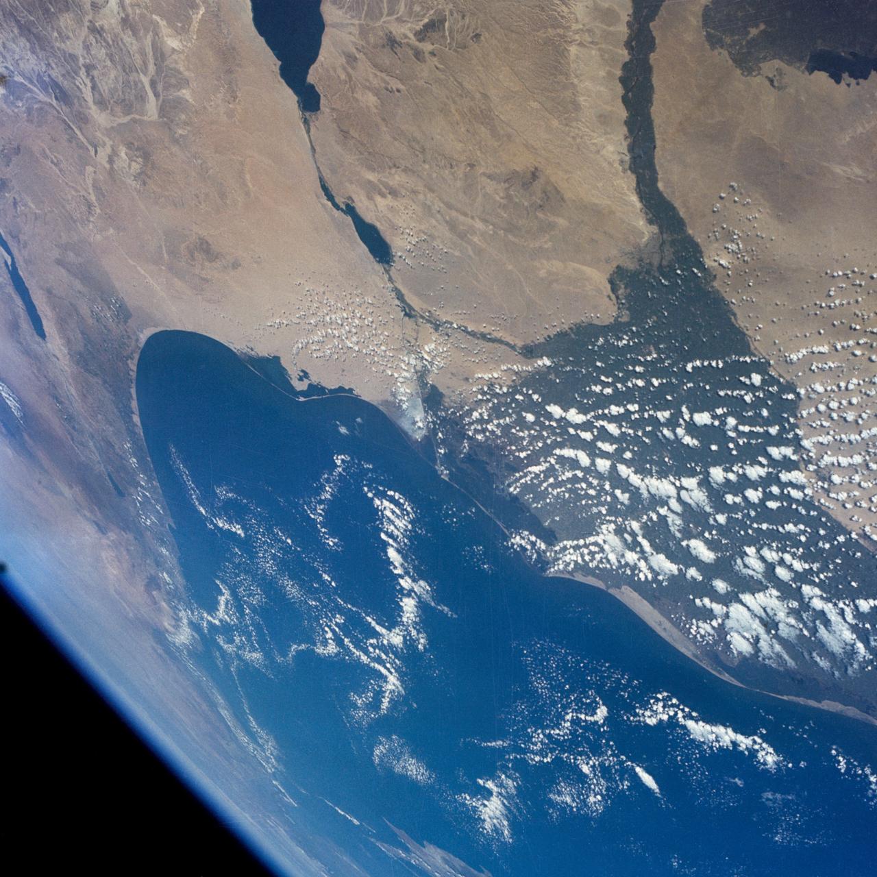
STS109-708-024 (1-12 March 2002) --- The astronauts on board the Space Shuttle Columbia took this 70mm picture featuring the Sinai Peninsula and the Dead Sea Rift. The left side of the view is dominated by the great triangle of the Sinai peninsula, which is partly obscured by an unusual cloud mass on this day. The famous Monastery of St. Catherine lies in the very remote, rugged mountains in the southern third of the peninsula (foreground). The Gulf of Aqaba is a finger of the Red Sea bottom center, pointing north to the Dead Sea, the small body of water near the center of the view. According to NASA scientists studying the STS-109 photo collection, the gulf and the Dead Sea are northerly extensions of the same geological rift that resulted in the opening of the Red Sea . The Gulf of Suez appears in the lower left corner. Northwest Saudi Arabia occupies the lower right side of the view, Jordan and Syria the right and top right, and the Eastern Mediterranean Sea the top left. Thin white lines of cloud have formed along the coastal mountains of southern Turkey and stretch across the top of the view near the Earth's limb.
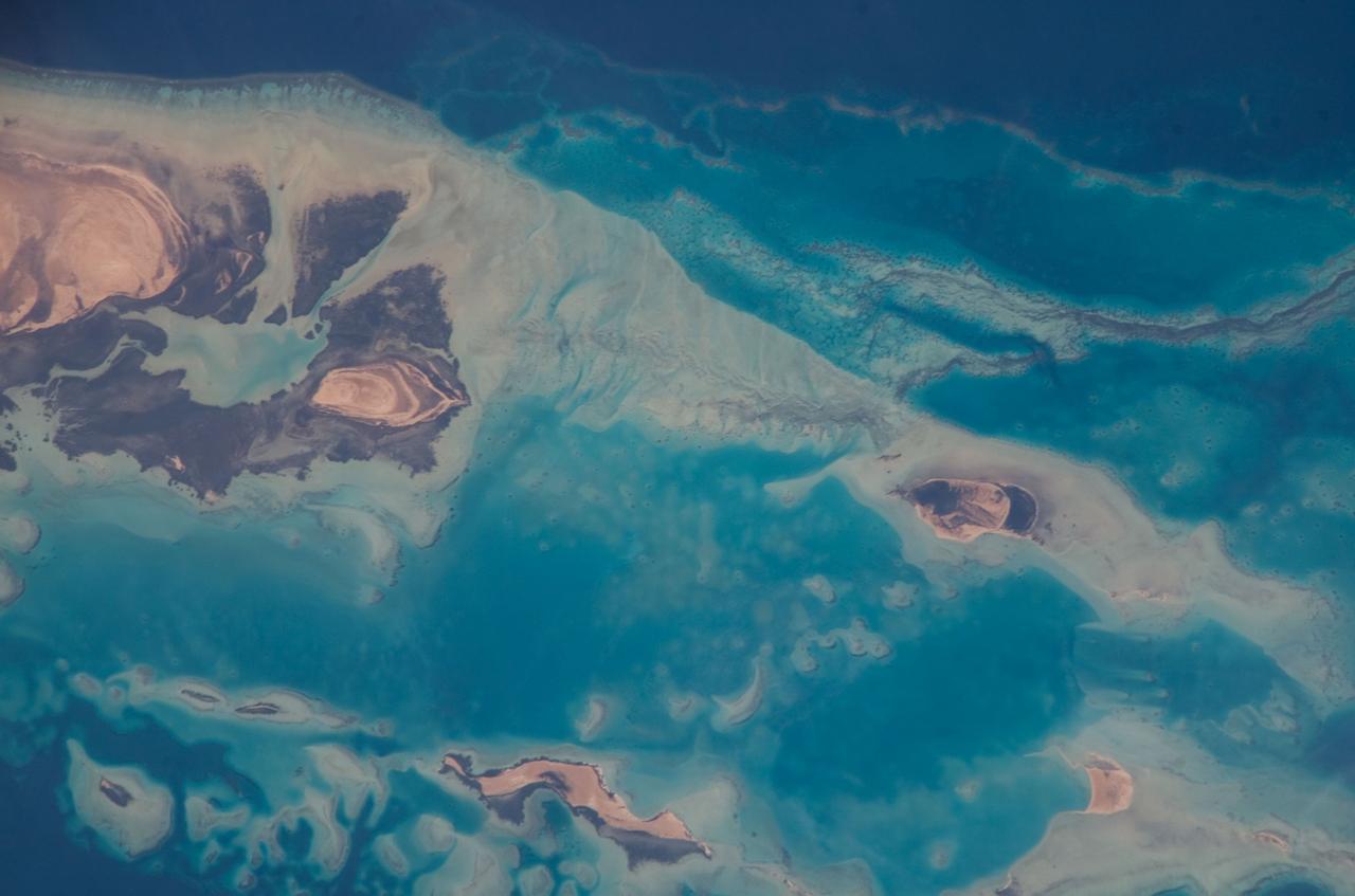
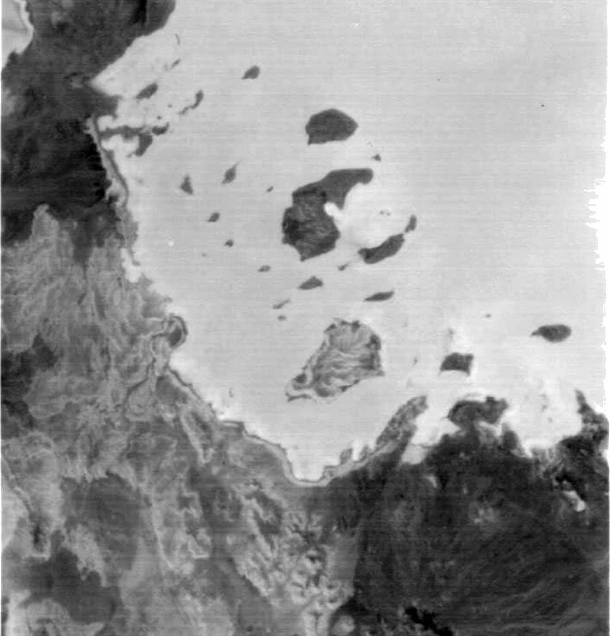
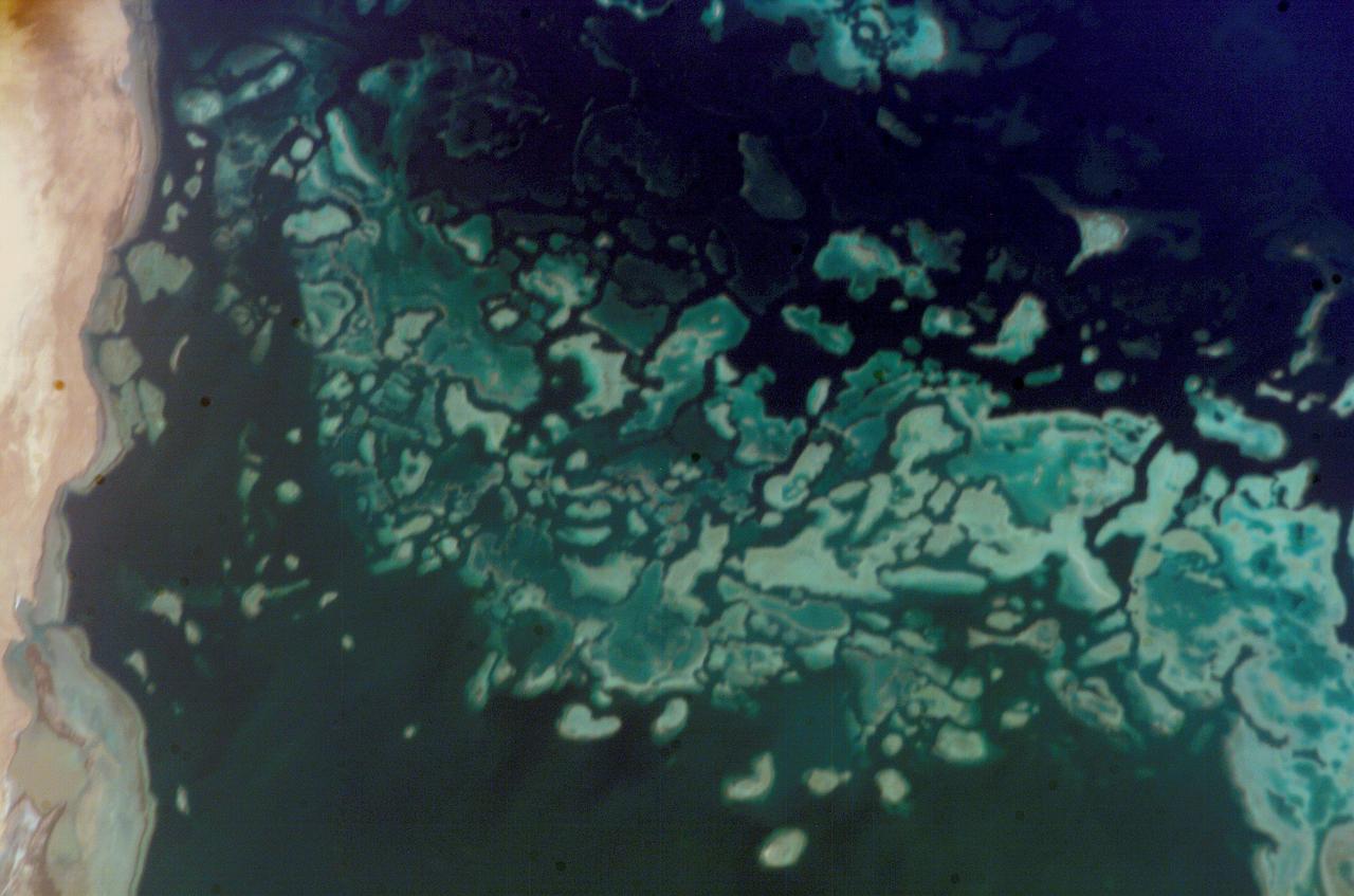
ISS016-E-019394 (30 Dec. 2007) --- Al Wadj Bank, Saudi Arabia is featured in this image photographed by an Expedition 16 crewmember on the International Space Station. Saudi Arabia boasts the most coral reefs of any Middle Eastern country, as it includes coastline along both the Red Sea and Gulf of Arabia. This high resolution image depicts a portion of the Al Wadj Bank, located along the northern Red Sea coast. Despite the relatively high salinity of Red Sea water (compared to other oceans), approximately 260 species of coral are found here, according to scientists. Large tracts of the Saudi Arabian coastline are undeveloped, and reefs in these areas are in generally good ecological health. However, reefs located near large urban centers like Jeddeh have suffered degradation due to land reclamation, pollution, and increased terrigeneous sediment input. The Al Wadj Bank includes a healthy and diverse reef system, extensive seagrass beds, and perhaps the largest population of dugong -- a marine mammal similar to the North American manatee -- in the eastern Red Sea. The portion of the Bank in this image illustrates the complex form and topography of the reef system. Several emergent islands (tan) - surrounded primarily by dark green seagrass - are visible, the largest located at top left. Only the islands are above the waterline -- over the reef structures the water color ranges from light teal (shallow) to turquoise (increasing depth). The southern edge of the reef is well indicated by the deep, dark blue water of the Red Sea at image top.

ISS036-E-011050 (22 June 2013) --- An Egyptian dust plume and the Red Sea are featured in this image photographed by an Expedition 36 crew member on the International Space Station. This photograph provides a panoramic view of most of the length of the Red Sea, with the northernmost end, the Gulf of Suez, just visible at top center—fully 1,900 kilometers (ground distance) from the space station. The River Nile snakes its way northward through the Sahara Desert at top left. Much closer to the camera—but still more than 550 kilometers distant from the ground point above which the space station is orbiting—is a prominent dust plume surging out over the clear water of the Red Sea (foreground), reaching most of the way to Saudi Arabia. The “point source” of this plume is the delta of the southern Egyptian river Khor Baraka. Images from the spacecraft have shown that this delta is a common source for dust plumes, mainly because it is a relatively large area of exposed, loose sand and clay, easily lofted into the air. But the river also cuts through a high range of hills in a narrow valley that channels the wind, making it blow faster. This dramatic view of the Red Sea shows the generally parallel margins of the opposing coastlines. According to scientists, the rift or depression which now holds the Red Sea has been opening slowly for about 30 million years, and is nearly 300 kilometers wide in the region of the dust plume. Scientists believe the depression only recently filled with seawater within the last approximately five million years.
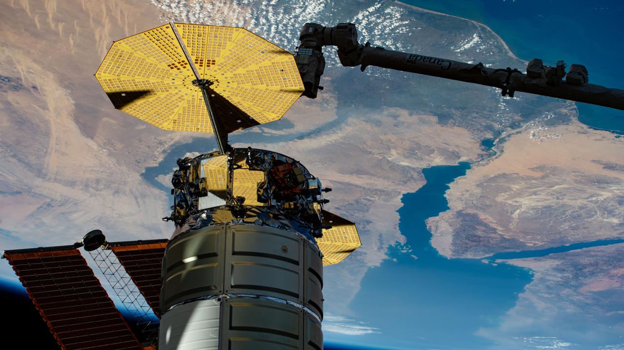
iss073e0767188 (Sept. 23, 2025) --- Northrop Grumman's Cygnus XL cargo craft is pictured installed to the Unity module's Earth-facing port as the International Space Station orbited 259 miles above the Mediterranean Sea. The Red Sea and Egypt's Nile Delta are viewed from the vantage point of an external high definition camera on the orbital outpost. Extending from the upper right, is the Canadarm2 robotic arm that had captured Cygnus after its arrival on Sept. 18, 2025.
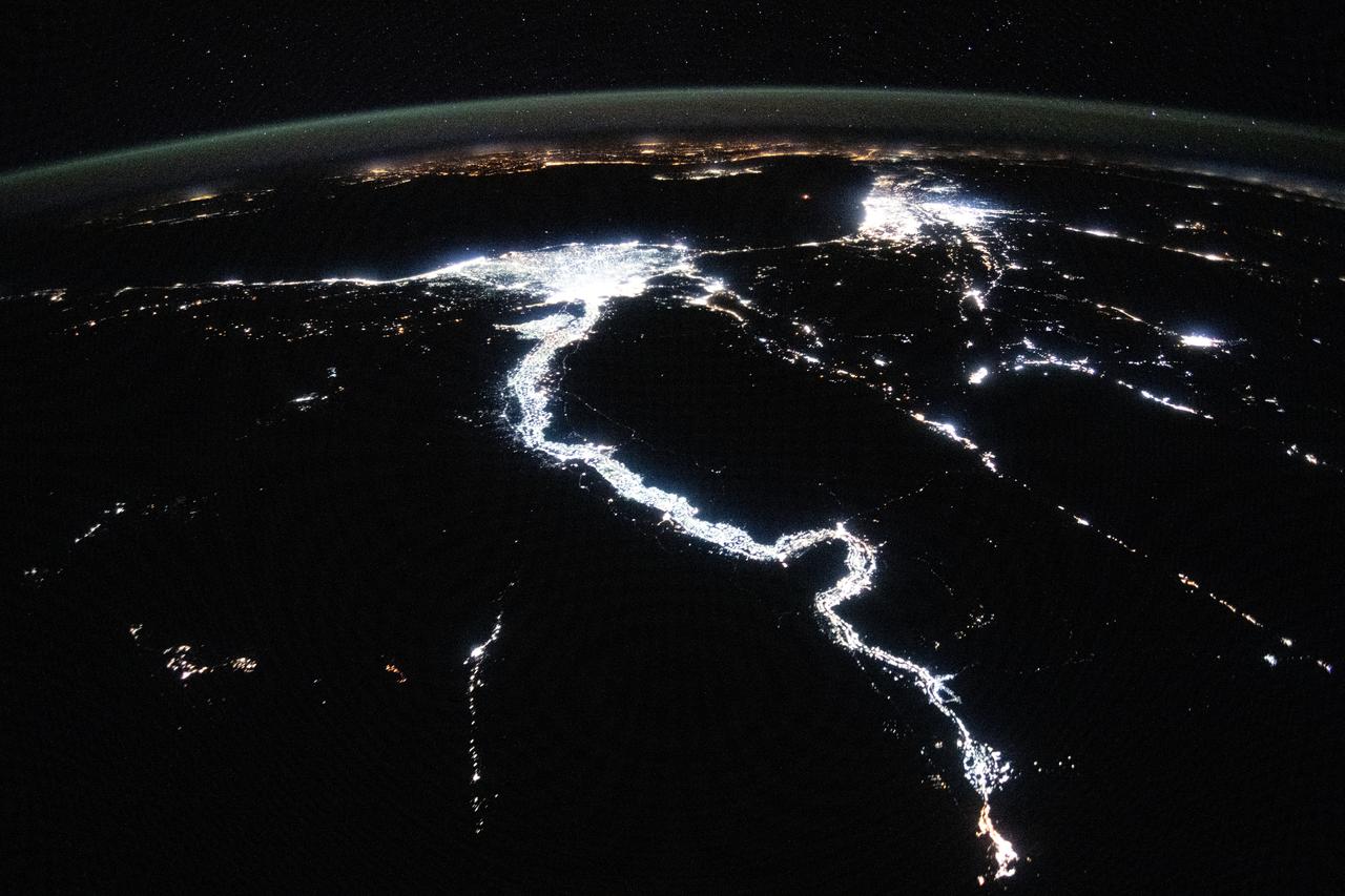
iss071e256968 (June 30, 2024) --- The night lights of civilization highlight the Nile River and dimly outline the shores of the Red Sea, the Gulf of Suez, and the Gulf of Adaba in the Middle East. The nations of Israel, Jordan, and Syria, as well as the Southern European region across the darkness of the Mediterranean Sea also are well lit in this photograph taken from the International Space Station at approximately midnight local time in Cairo, Egypt.
ISS009-E-23808 (20 September 2004) --- A fringing coral reef in the Red Sea is featured in this image photographed by an Expedition 9 crewmember on the International Space Station (ISS). The Sudanese coast of the Red Sea is a well known destination for divers due to clear water and abundance of coral reefs (or “shia’ab” in Arabic). According to NASA scientists studying the ISS imagery, reefs are formed primarily from precipitation of calcium carbonate by corals; massive reef structures are built over thousands of years of succeeding generations of coral. In the Red Sea, fringing reefs form on shallow shelves of less than 50 meters depth along the coastline. This photograph illustrates the intricate morphology of the reef system located along the coast between Port Sudan to the northwest and the Tokar River delta to the southeast. Close to shore, fringing reefs border the coastline. Farther offshore grows a larger, more complicated barrier reef structure. Different parts of the reef structure show up as variable shades of light blue. Deeper water channels (darker blue) define the boundaries for individual reefs within the greater barrier reef system. Such a complex pattern of reefs may translate into greater ecosystem diversity through a wide variety of local reef environments.
This map shows sea level measured by the Sentinel-6 Michael Freilich satellite from June 5 to15. Red areas are regions where sea level is higher than normal, and blue areas indicate areas where it's lower than normal. The measurements are part of a set of data streams that become available to the public hours to a couple of days after the satellite collects them. The difference in when the products become available balances accuracy with delivery timeliness for tasks like forecasting the weather or helping to monitor the formation of hurricanes. The satellite, named after former NASA Earth Science Division Director Michael Freilich, collects its measurements for about 90% of the world's oceans. The spacecraft is one of two satellites that compose the Copernicus Sentinel-6/Jason-CS (Continuity of Service) mission. The second satellite, Sentinel-6B, is slated for launch in 2025. Together, they are the latest in a series of spacecraft starting with TOPEX/Poseidon in 1992 and continuing with the Jason series of satellites that have been gathering precise ocean height measurements for nearly 30 years. Shortly after launch in Nov. 2020, Sentinel-6 Michael Freilich moved into position, trailing the current reference sea level satellite Jason-3 by 30 seconds. Scientists and engineers then spent time cross-calibrating the data collected by both satellites to ensure the continuity of measurements between the two. Once assured of the data quality, Sentinel-6 Michael Freilich will then become the primary sea level satellite. https://photojournal.jpl.nasa.gov/catalog/PIA24533
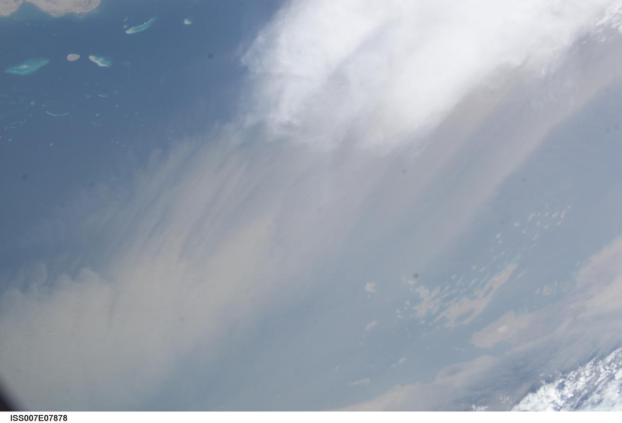
ISS007-E-07878 (22 June 2003) --- This image, photographed by an Expedition 7 crewmember onboard the International Space Station (ISS), was merged with image ISS007-E-07872 to create a mosaic of a dust storm and thunderstorm over the Red Sea. The mosaic can be viewed on http://eol.jsc.nasa.gov

S131-E-008949 (10 April 2010) --- The aft section of the docked space shuttle Discovery and the station?s robotic Canadarm2 are featured in this image photographed by an STS-131 crew member on the International Space Station. The Red Sea, Sinai Peninsula (center) and Nile River (left) are seen approximately 215 miles below.
iss069e033356 (July 19, 2023) -- Eastern Africa meets the Middle East as the Red Sea and Gulf of Aden flow between the regions. United Arab Emirates (UAE) Flight Engineer Sultan Alneyadi snapped this photograph during Crew Earth Observation tasks while the International Space Station soared roughly 260 miles above.
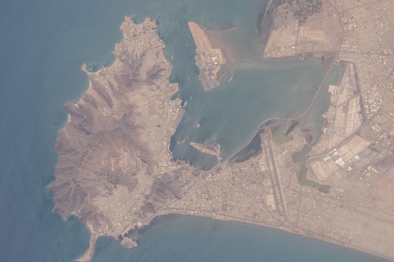
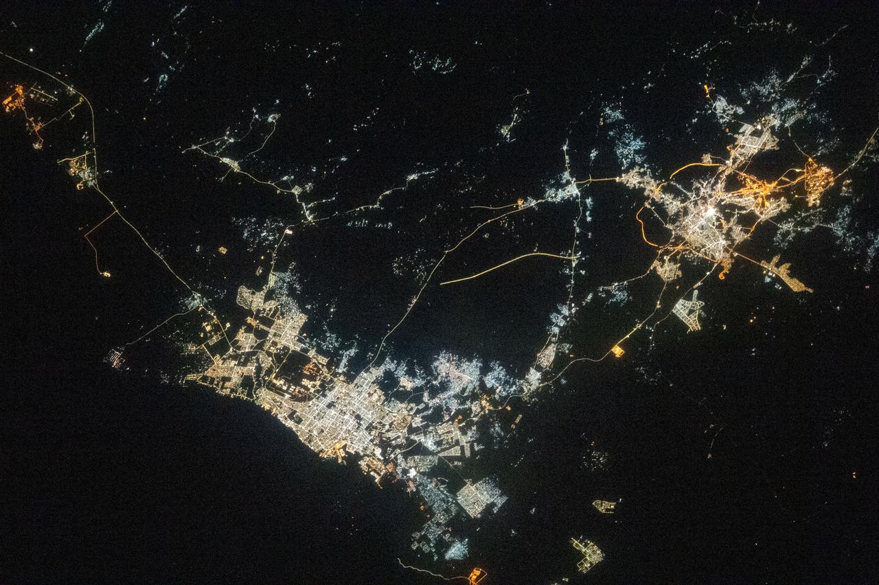
iss064e021924 (Jan. 9, 2021) ---Jeddah, Saudi Arabia, the desert nation's second-most populous city with 3.5 million residents, is pictured from the International Space Station as it orbited 261 miles above the Red Sea during a night time pass. The landmark towards the center left is the King Abdulaziz International Airport.
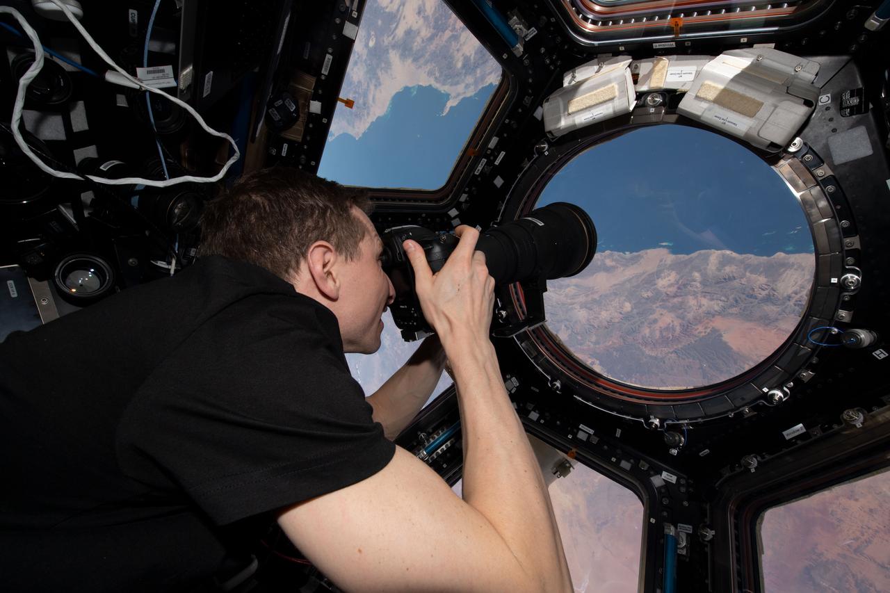
iss069e012505 (May 20, 2023) --- NASA astronaut and Expedition 69 Flight Engineer Woody Hoburg is pictured inside the seven window cupola photographing the Saudi Arabian coast on the Red Sea as the International Space Station orbited 258 miles above.
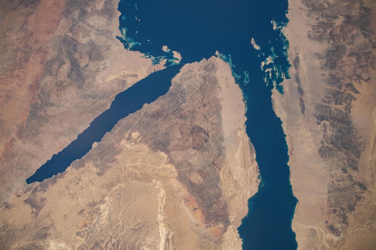
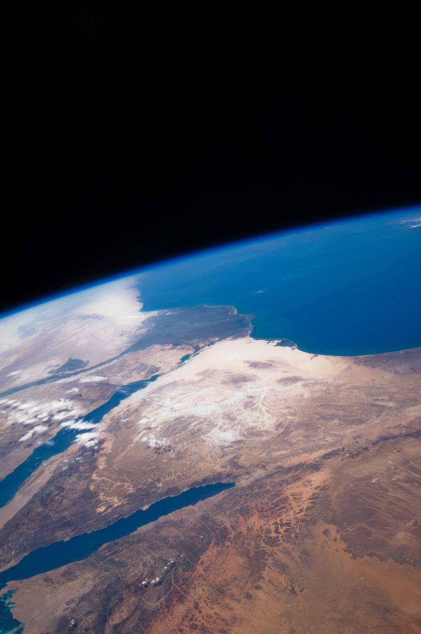
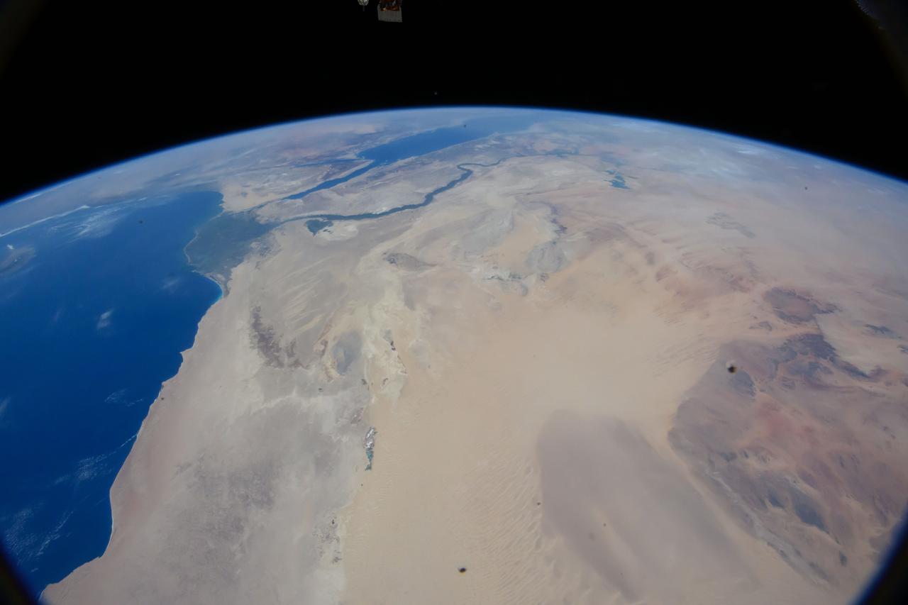
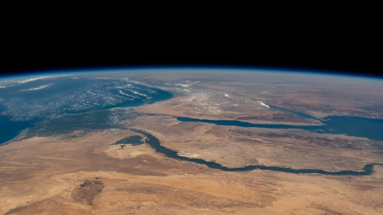
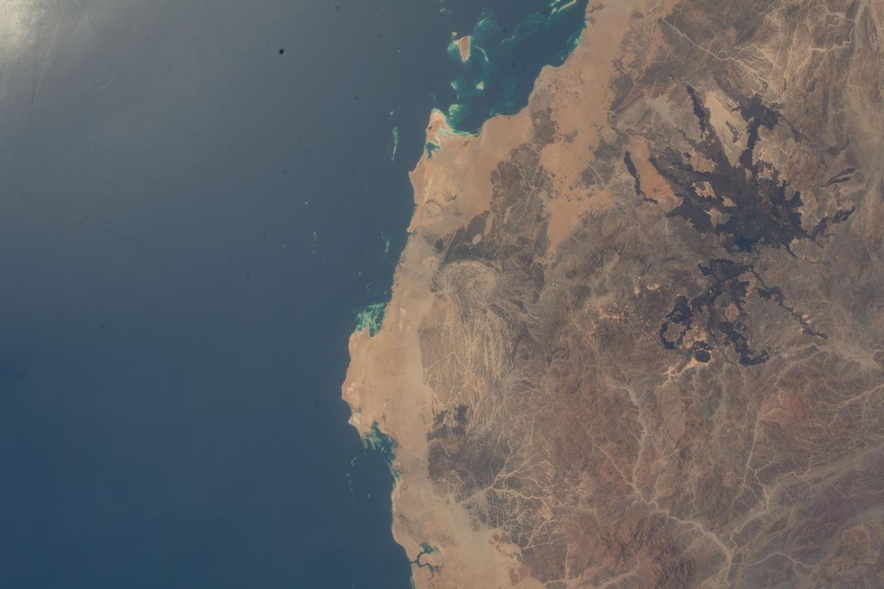
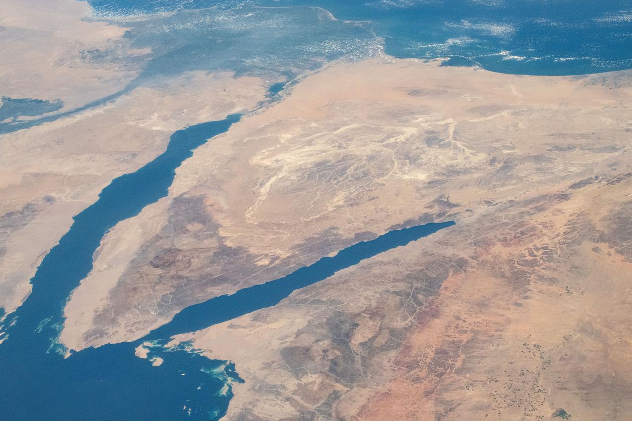
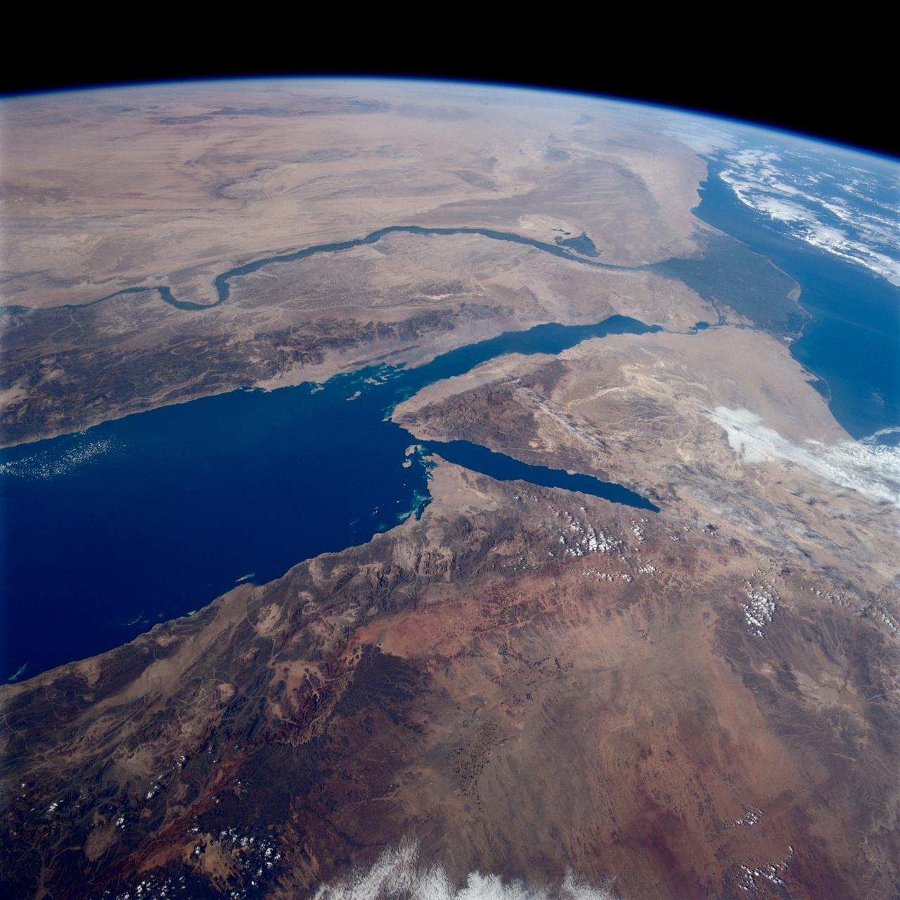
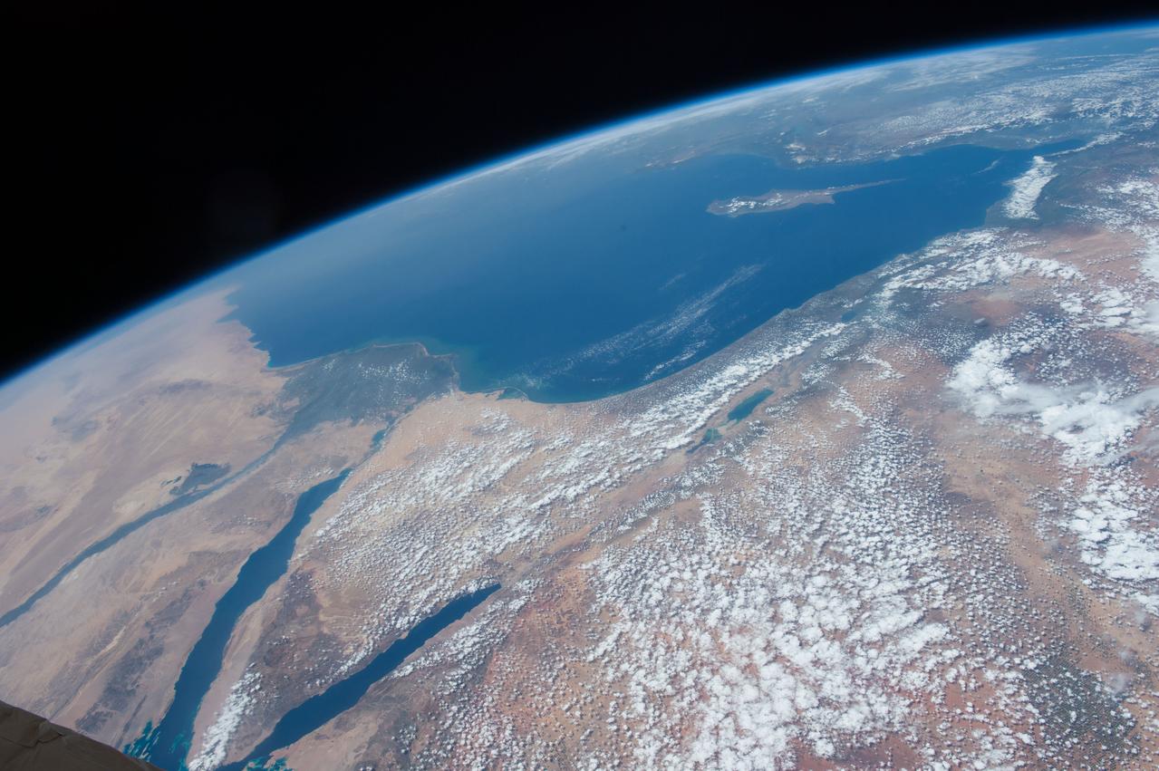
iss071e183804 (June 14, 2024) -- At the northern end of the Red Sea, the Gulf of Aqaba (left) and Gulf of Suez (right) are surrounded by the dry, rugged terrain of Egypt and Saudi Arabia. This photograph was taken as the International Space Station orbited 262 miles above.
ISS033-E-013636 (20 Oct. 2012) --- One of the Expedition 33 crew members aboard the International Space Station took this oblique photograph showing part of the Red Sea and the Gulf of Aden. Areas that are easily recognized in the picture include parts of Eritrea, Yemen and Ethiopia. Slight haze is also visible.
iss071e578476 (Aug. 14, 2024) --- The Nile River runs alongside the Red Sea in this photograph from the International Space Station as it orbited 258 miles above the Middle East. At lower left, is one of the two cymbal-shaped UltraFlex solar arrays that power the Northrop Grumman space freighter.
ISS047e111682 (05/09/2016) --- This Image from the International Space Station is of the middle eastern country of Yemen and its ancient port of Aden located by the eastern approach to the Red Sea. Aden's ancient, natural harbor lies in the crater of a dormant volcano which now forms a peninsula, joined to the mainland by a low isthmus.
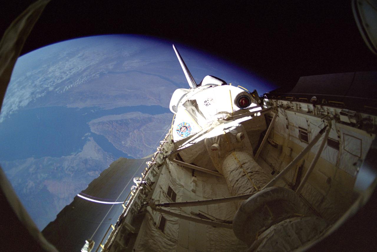
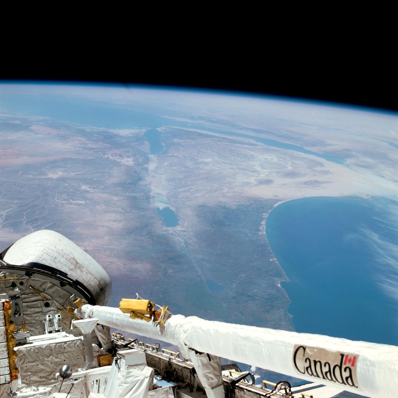
STS042-25-027 (30 Jan 1992) --- STS-42 International Microgravity Laboratory 1 (IML-1) Spacelab module and Spacelab tunnel (foreground) exteriors are documented in the payload bay (PLB) of Discovery, Orbiter Vehicle (OV) 103, and backdropped against the Red Sea and part of the Sinai Peninsula.
ISS042E237341 (02/09/2015) --- Twitter image from US Astronaut Terry Virts of the Red Sea in the Middle East on Feb. 09, 2015. Terry labeled it "earth art." Terry is a flight engineer of Expedition 42 on the International Space Station.
iss068e076629 (March 26, 2023) --- The night lights of the Saudi Arabian cities of Jeddah (lower left) and Mecca (upper right) contrast with the darkness of the Red Sea and the surrounding desert in this photograph from International Space Station as it orbited 258 miles above.
ISS033-E-013632 (20 Oct. 2012) --- This oblique photo of Ethiopia and part of the Red Sea was photographed by one of the Expedition 33 crew members aboard the International Space Station. The name of the funnel-shaped area is the Afar Depression or Afar Triangle. The green body of water is Lake Tana, connected to the Blue Nile.
ISS042E037847 (12/15/2014) ---ESA (European Space Agency) astronaut Samantha Cristoforetti captured this image while on the International Space Station. It shows cloud cover over England, Baltic Sea and the Persian Gulf. It also displays a golden aurora with a splash of red through the stars during the night of Dec. 15, 2014.
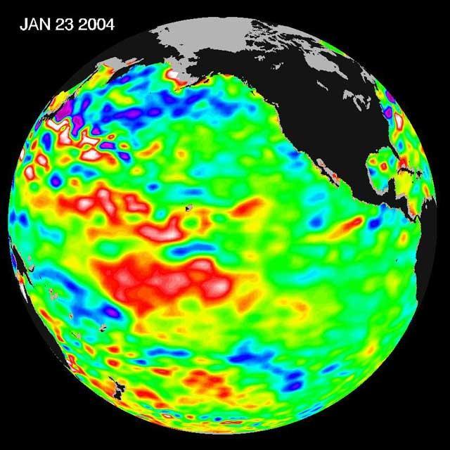
The latest remote sensing data from NASA's Jason satellite show that the equatorial Pacific sea surface levels are higher, indicating warmer sea surface temperatures in the central and west Pacific Ocean. This pattern has the appearance of La Niña rather than El Niño. This contrasts with the Bering Sea, Gulf of Alaska and U.S. West Coast where lower-than-normal sea surface levels and cool ocean temperatures continue (indicated by blue and purple areas). The image above is a global map of sea surface height, accurate to within 30 millimeters. The image represents data collected and composited over a 10-day period, ending on Jan 23, 2004. The height of the water relates to the temperature of the water. As the ocean warms, its level rises; and as it cools, its level falls. Yellow and red areas indicate where the waters are relatively warmer and have expanded above sea level, green indicates near normal sea level, and blue and purple areas show where the waters are relatively colder and the surface is lower than sea level. The blue areas are between 5 and 13 centimeters (2 and 5 inches) below normal, whereas the purple areas range from 14 to 18 centimeters (6 to 7 inches) below normal. http://photojournal.jpl.nasa.gov/catalog/PIA05071
S66-54893 (14 Sept. 1966) --- Near East area as seen from the orbiting Gemini-11 spacecraft during its 26th revolution of Earth. The United Arab Republic (Egypt) is in foreground. Triangular-shaped area is the Sinai Peninsula. Saudi Arabia is at upper right. The Mediterranean Sea is at upper left. The Gulf of Suez separates Egypt from the Sinai Peninsula. The Red Sea is at bottom right. The Gulf of Aqaba is the body of water in right center of photograph separating the Sinai Peninsula and the Arabian Peninsula. The Dead Sea, Sea of Galilee, Jordan and Israel are in top center of picture. Iraq is at top right edge of photograph. Taken with a J. A. Maurer 70mm camera, using Eastman Kodak, Ektachrome, MS (S.O. 368) color film. Photo credit: NASA
S65-63849 (8 Dec. 1965) --- The eastern Mediterranean area as seen from the National Aeronautics and Space Administration's Gemini-7 spacecraft. The Nile Delta in Egypt is at bottom. The Suez Canal, Gulf of Suez and Red Sea are in the center of the photograph. The Sinai Peninsula is in the upper right corner of the picture. The body of water at the top edge of the photograph is the Gulf of Aqaba. The Dead Sea can be seen at top center. Israel, Palestine, Jordan and Syria are also at top center. The Island of Cyprus is at extreme left. Astronauts Frank Borman and James A. Lovell Jr. took this picture using a modified 70mm Hasselblad camera, with Eastman Kodak, Ektachrome MS (S.O. 217) color film. Photo credit: NASA
STS040-152-180 (5-24 June 1991) --- The Sinai Peninsula dominates this north-looking, oblique view. According to NASA photo experts studying the STS 40 imagery, the Red Sea in the foreground is clear of river sediment because of the prevailing dry climate of the Middle East. The great rift of the Gulf of Aqaba extends northward to Turkey (top right) through the Dead Sea. The international boundary between Israel and Egypt, reflecting different rural landscapes, stands out clearly. The Nile River runs through the frame. NASA photo experts believe the haze over the Mediterranean to be wind-borne dust. The photo was taken with an Aero-Linhof large format camera.
This southerly looking view photographed from the orbiting Space Shuttle Columbia shows a small portion of the vehichle's aft section. The 50-ft Canadian built remote manipulator system (RMS) is in a resting posture (lower right corner) stretched out along the 60-ft. long cargo bay. Many of the components of the OSS-1 payload package are in the bottom center. The Mediterranean Sea is at right foreground. Parts of the Sinai peninsula, Israel, Egypt, Saudi Arabia, Jordan, Palestine, Syria, and Lebanon can be located in the photo. The Red Sea, Gulf of Aqaba, Suez Canal are near the photo's horizon.
STS080-745-004 (19 Nov.-7 Dec. 1996) --- A view to the west showing Asia in the foreground and Africa in the background, as photographed by the space shuttle Columbia crewmembers. The Mediterranean Sea is to the upper right and the Red Sea to the lower left (holding photograph with NASA numbers on left). Sinai Peninsula is between the two with the Gulf of Suez above and the Gulf of Aqaba below. The Suez Canal connects the Gulf of Suez with the Mediterranean Sea. The triangular shaped dark area beyond is the Nile River Delta. The thin green fertile valley of the Nile crosses the photograph from a point at Cairo (near dark triangle area) past the great bend at Luxor with Thebes and the Valley of the Kings, and on the left into the Nubian Desert with the Aswan High Dam at the very left edge of the photograph. To the horizon is the Western Desert of Egypt and Libya. The foreground is the northwest portion of Saudi Arabia, an area known as the Hejaz with the southern portions of Israel and Jordan to the lower right.
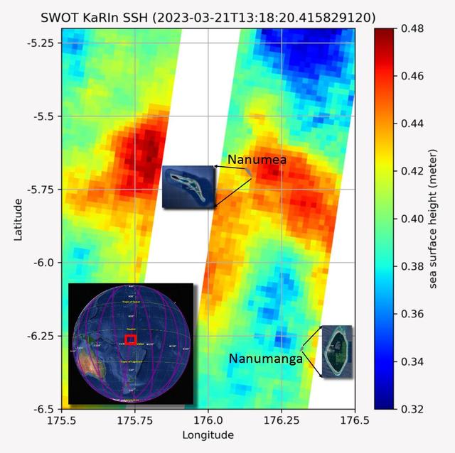
The recently launched Surface Water and Ocean Topography (SWOT) mission collected data on sea levels around two of the inhabited islands of Tuvalu, a nation in the South Pacific Ocean that has been threatened with sea level rise that substantially exceeds the global average. The image shows two areas of red that indicate higher than normal sea levels around two of Tuvalu's inhabited islands, Nanumanga and Nanumea. The higher sea levels were likely caused by internal tides or circular currents called eddies. The SWOT data illuminates for the first time these small ocean features that, when they occur on top of rising sea levels, can lead to episodic flooding along coastlines. The Tuvalu data was collected March 21, 2023. Rising seas are a direct consequence of climate change. On a global scale, the combination of warming ocean waters and ice melt from glaciers and ice sheets is leading to sea level rise that is occurring at an ever-increasing rate. The current rate of rise is more than 0.15 inches (4 millimeters) per year, an increase from 0.08 inches (2 millimeters) per year in 1993. This seemingly small increase holds great significance for coastal communities that have seen more than a century of persistent sea level rise. The gap between the average high tide and flooding conditions has narrowed, and coastal impacts driven by sea level rise have increased in frequency and severity in recent years. This is particularly true for low-lying island nations like Tuvalu, located about 620 miles (1,000 kilometers) north of Fiji. Sea level rise does not occur at the same rate everywhere across the globe, and can be exacerbated by natural ocean fluctuations that occur over time periods from years to decades. For Tuvalu, the amount of sea level rise has been substantially higher than the global average over the past three decades. The amount of rise, when coupled with Tuvalu's low land elevations, places the country increasingly under threat. In the near term, sea level rise will combine with naturally occurring ocean variability and storms to exacerbate events like coastal flooding. Monitoring and understanding sea level change is critical for Tuvalu and other low-lying island nations. Launched on Dec. 16, 2022, from Vandenberg Space Force Base in central California, SWOT collected the Tuvalu sea level data during a period of commissioning, calibration, and validation. Engineers are checking out the performance of the satellite's systems and science instruments before the planned start of science operations in summer 2023. https://photojournal.jpl.nasa.gov/catalog/PIA25777
ISS039-E-013569 (20 April 2014) --- This is one of an extensive series of still photos documenting the April 20 arrival and ultimate capture and berthing of the SpaceX Dragon at the International Space Station, as photographed by the Expedition 39 crew members onboard the orbital outpost. In this photo, the two orbiting spacecraft were above a point in Yemen. Part of the Gulf of Aden and the Red Sea, can be seen at left. The Dragon spacecraft was captured by the space station and successfully berthed using the Canadian-built space station remote manipulator system or Canadarm2.

ISS039-E-013567 (20 April 2014) --- This is one of an extensive series of still photos documenting the April 20 arrival and ultimate capture and berthing of the SpaceX Dragon at the International Space Station, as photographed by the Expedition 39 crew members onboard the orbital outpost. In this photo, the two orbiting spacecraft were above a point in Yemen. Part of the Gulf of Aden and the Red Sea, can be seen at left. The Dragon spacecraft was captured by the space station and successfully berthed using the Canadian-built space station remote manipulator system or Canadarm2.
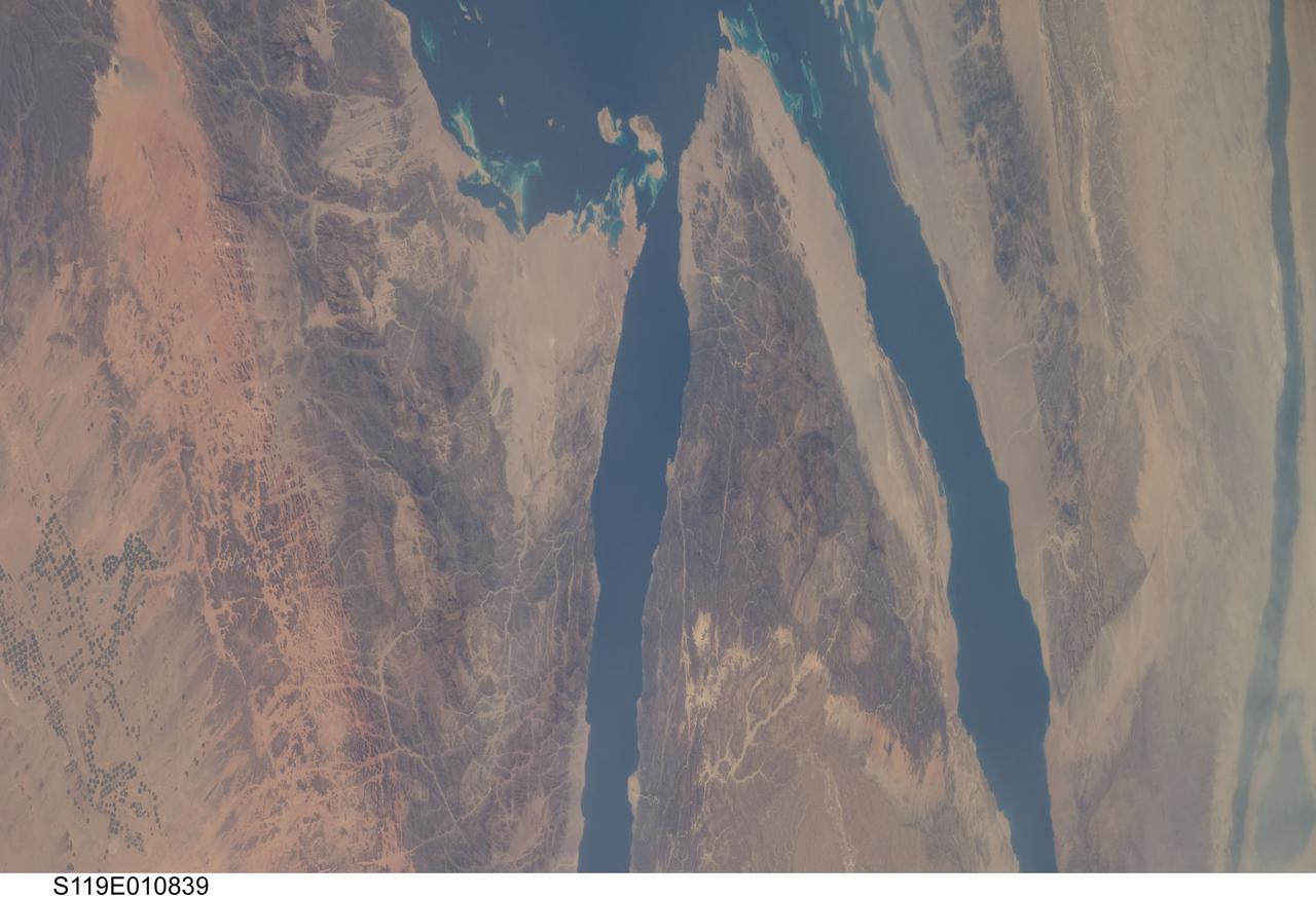
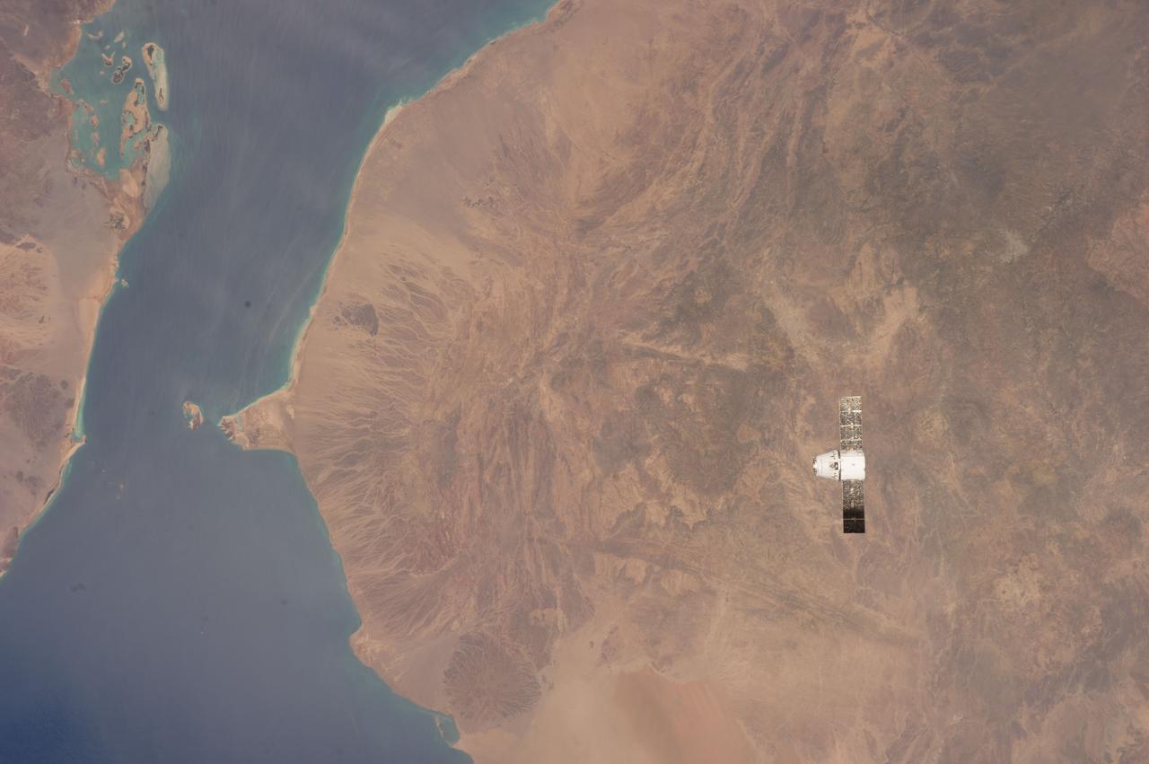
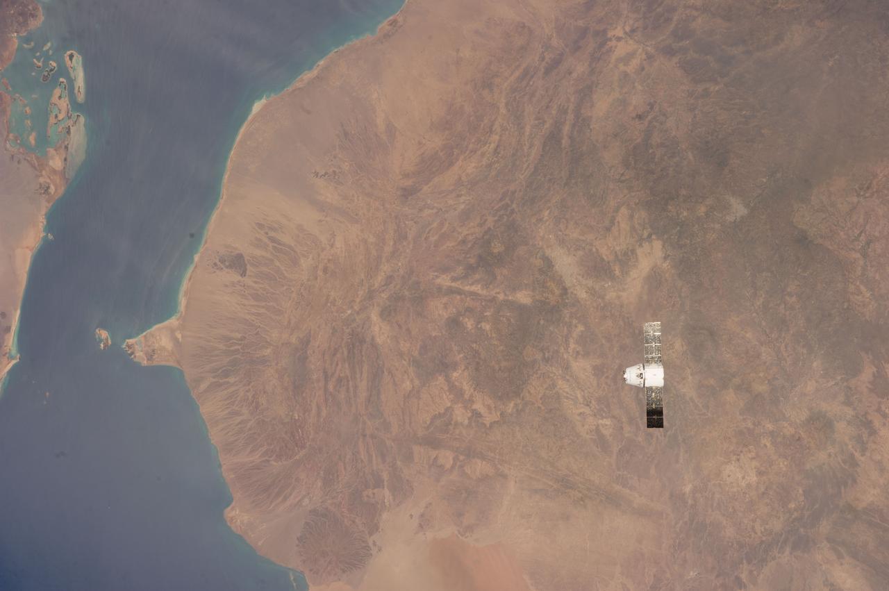
S119-E-010839 (27 March 2009) --- On its final full day in space before its scheduled return home on March 28, the crew of Space Shuttle Discovery took some pictures of the home planet, including this one of the Sinai Peninsula. The frame shows part of the Red Sea (top), Gulf of Suez (right of center), Nile River (far right edge), Gulf of Aqaba (center frame) and parts of the nations of Egypt, Jordan and Saudi Arabia.
ISS039-E-013405 (20 April 2014) --- This is one of an extensive series of still photos documenting the April 20 arrival and ultimate capture and berthing of the SpaceX Dragon at the International Space Station, as photographed by the Expedition 39 crew members onboard the orbital outpost. The two orbiting spacecraft were above a point in the Gulf of Aden near the Red Sea, off the coast of Yemen. The Dragon spacecraft was captured by the space station and successfully berthed using the Canadian-built space station remote manipulator system or Canadarm2.

STS111-321-024 (5-19 June 2002) --- This sunset over the Sahara Desert was photographed by the STS-111 crew members aboard the Space Shuttle Endeavour. When this photograph was taken, the shuttle was in a position over the Sudan near the Red Sea coast. The Gateway to Astronaut Photography of Earth (link to http://eol.jsc.nasa.gov/sseop/ ) provides searchable access to other photographs of Earth taken by astronauts.
ISS039-E-013570 (20 April 2014) --- This is one of an extensive series of still photos documenting the April 20 arrival and ultimate capture and berthing of the SpaceX Dragon at the International Space Station, as photographed by the Expedition 39 crew members onboard the orbital outpost. In this photo, the two orbiting spacecraft were above a point in Yemen. Part of the Gulf of Aden and the Red Sea, can be seen at left. The Dragon spacecraft was captured by the space station and successfully berthed using the Canadian-built space station remote manipulator system or Canadarm2.
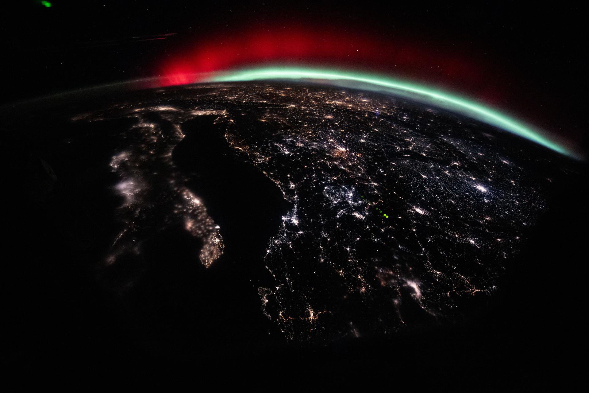
iss074e0150285 (Jan. 19, 2026) --- A green and red aurora streams across Earth’s horizon above the city lights of Europe in this photograph, which looks north across Italy toward Germany. The International Space Station was orbiting 262 miles above the Mediterranean Sea at approximately 10:02 p.m. local time when the image was captured. Credit: NASA/Chris Williams
S66-63533 (14 Nov. 1966) --- United Arab Republic (Egypt) area as seen from the Gemini-12 spacecraft during its 39th revolution of Earth, looking southeast. Nile River is in center of picture. At bottom center is the Sinai Peninsula. Arabian Peninsula is at lower left. Large body of water is Red Sea. Gulf of Aqaba is on east side of Sinai Peninsula. Gulf of Suez separates Sinai from Egyptian mainland. Photo credit: NASA
ISS039-E-013566 (20 April 2014) --- This is one of an extensive series of still photos documenting the April 20 arrival and ultimate capture and berthing of the SpaceX Dragon at the International Space Station, as photographed by the Expedition 39 crew members onboard the orbital outpost. In this photo, the two orbiting spacecraft were above a point in Yemen. Part of the Gulf of Aden and the Red Sea can be seen at left. The Dragon spacecraft was captured by the space station and successfully berthed using the Canadian-built space station remote manipulator system or Canadarm2.
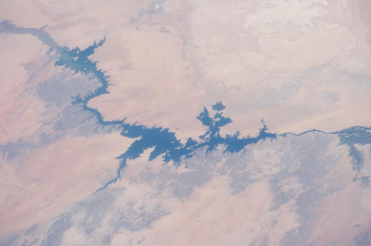
ISS040-E-105768 (23 Aug. 2014) --- One of the Expedition 40 crew members aboard the International Space Station, flying at an altitude of 221 nautical miles, captured this image of Egypt's Nile River and Lake Nasser on Aug. 23, 2014. The Aswan High Dam is to the right of center in the 70mm focal-length image, as the Nile flows southward (to the right in this image) toward Cairo and it?s Mediterranean delta (both out of frame at right). The Red Sea, which runs more or less parallel to the Nile, is out of frame at bottom.
ISS047e057822 (04/14/2016) --- The Middle East is seen from 250 miles above in this photo from the International Space Station. Countries seen left to right along the Mediterranean coast include Egypt, Gaza, Saudi Arabia, Israel, Lebanon, Syria, and Turkey. The major waterways shown from left to right are the Nile River, Gulf of Suez, Gulf of Aqaba, and the Red Sea.