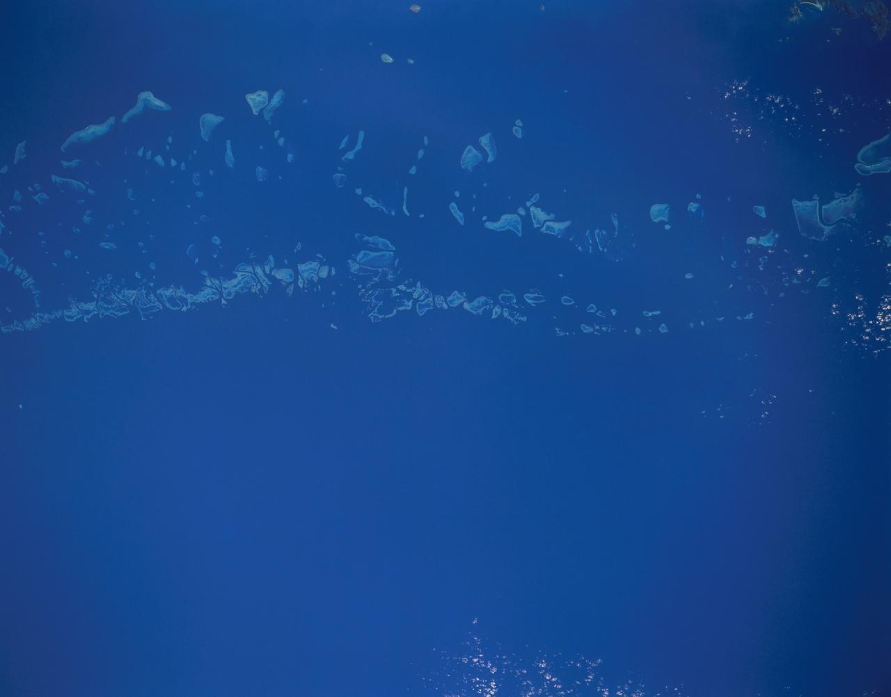
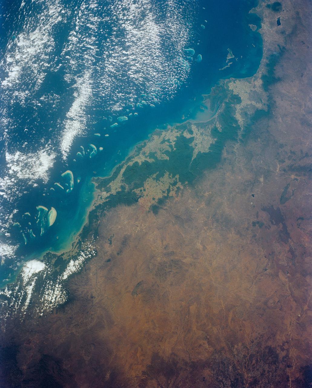
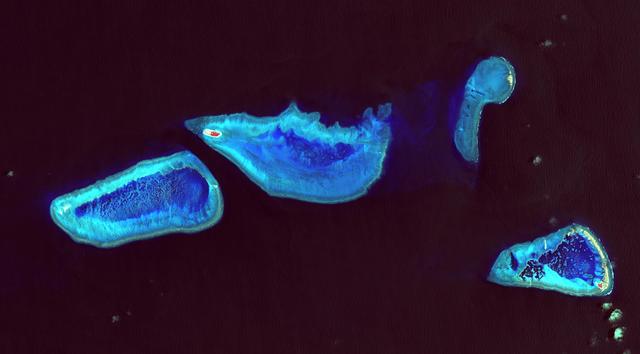
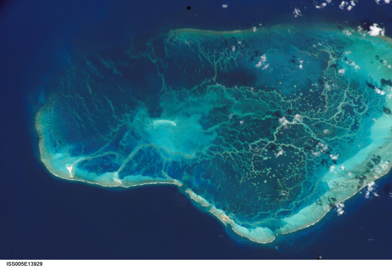
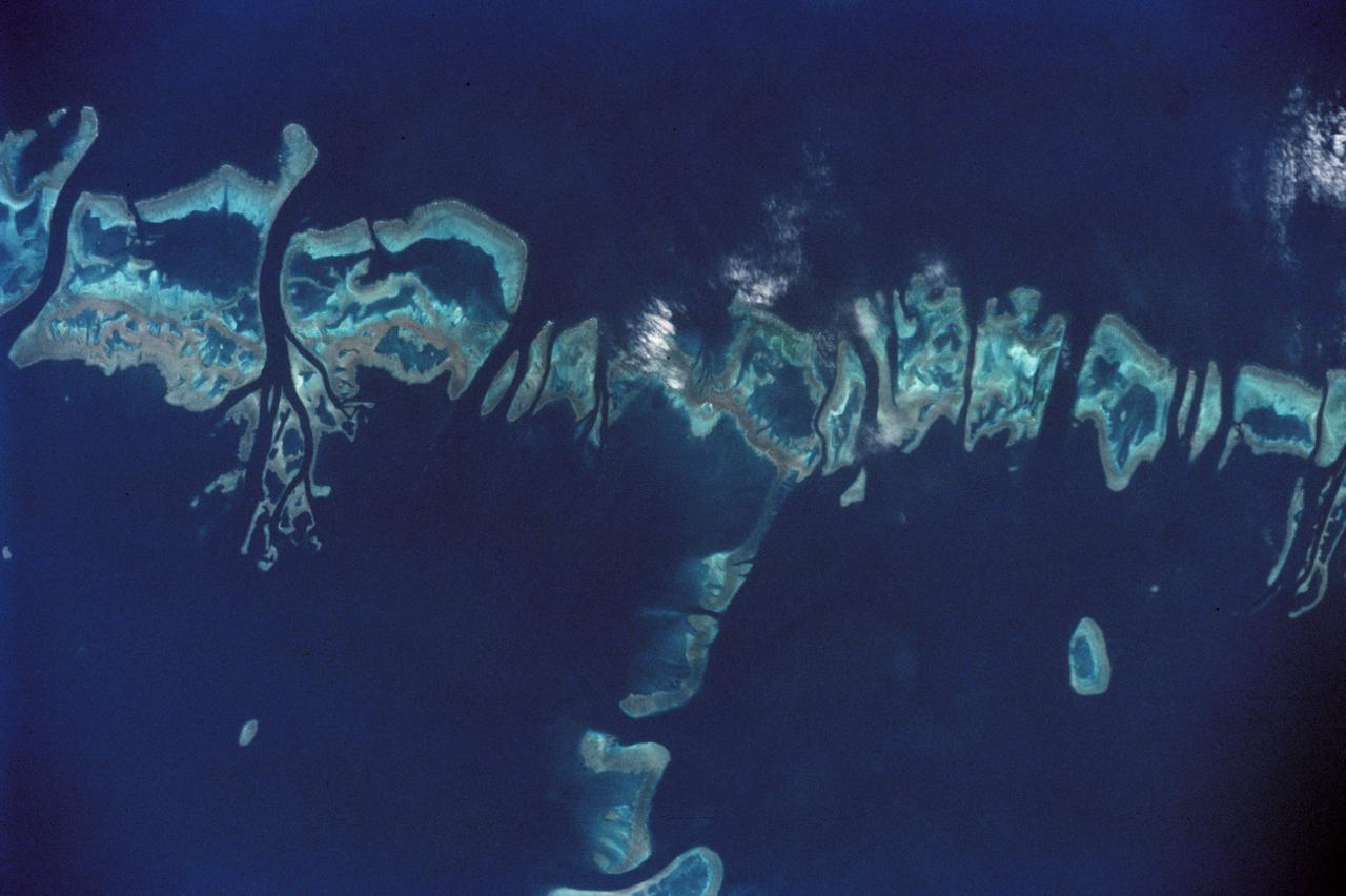
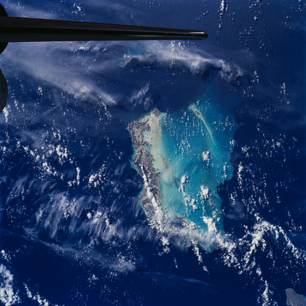
STS048-151-250 (12-18 Sept. 1991) --- The Great Barrier Reef extends for roughly 2,000 kilometers along the northeast coast of Australia. The great Barrier Reef is made up of thousands of individual reefs which define the edge of the continental shelf. The southern part of the feature, called Swain Reef, is seen here. Water depths around the reefs are quite shallow (less than 1 meter to about 36 meters in depth), but only a few kilometers offshore, water depths are roughly 1,000 meters.
The Great Barrier Reef extends for 2,000 kilometers along the northeastern coast of Australia. It is not a single reef, but a vast maze of reefs, passages, and coral cays islands that are part of the reef.
Great Barrier Reef - August 8th, 1999 Description: What might be mistaken for dinosaur bones being unearthed at a paleontological dig are some of the individual reefs that make up the Great Barrier Reef, the world's largest tropical coral reef system. The reef stretches more than 2,000 kilometers (1,240 miles) along the coast of Queensland, Australia. It supports astoundingly complex and diverse communities of marine life and is the largest structure on the planet built by living organisms. Credit: USGS/NASA/Landsat 7 To learn more about the Landsat satellite go to: <a href="http://landsat.gsfc.nasa.gov/" rel="nofollow">landsat.gsfc.nasa.gov/</a> <b><a href="http://www.nasa.gov/centers/goddard/home/index.html" rel="nofollow">NASA Goddard Space Flight Center</a></b> enables NASA’s mission through four scientific endeavors: Earth Science, Heliophysics, Solar System Exploration, and Astrophysics. Goddard plays a leading role in NASA’s accomplishments by contributing compelling scientific knowledge to advance the Agency’s mission. <b>Follow us on <a href="http://twitter.com/NASA_GoddardPix" rel="nofollow">Twitter</a></b> <b>Join us on <a href="http://www.facebook.com/pages/Greenbelt-MD/NASA-Goddard/395013845897?ref=tsd" rel="nofollow">Facebook</a></b>
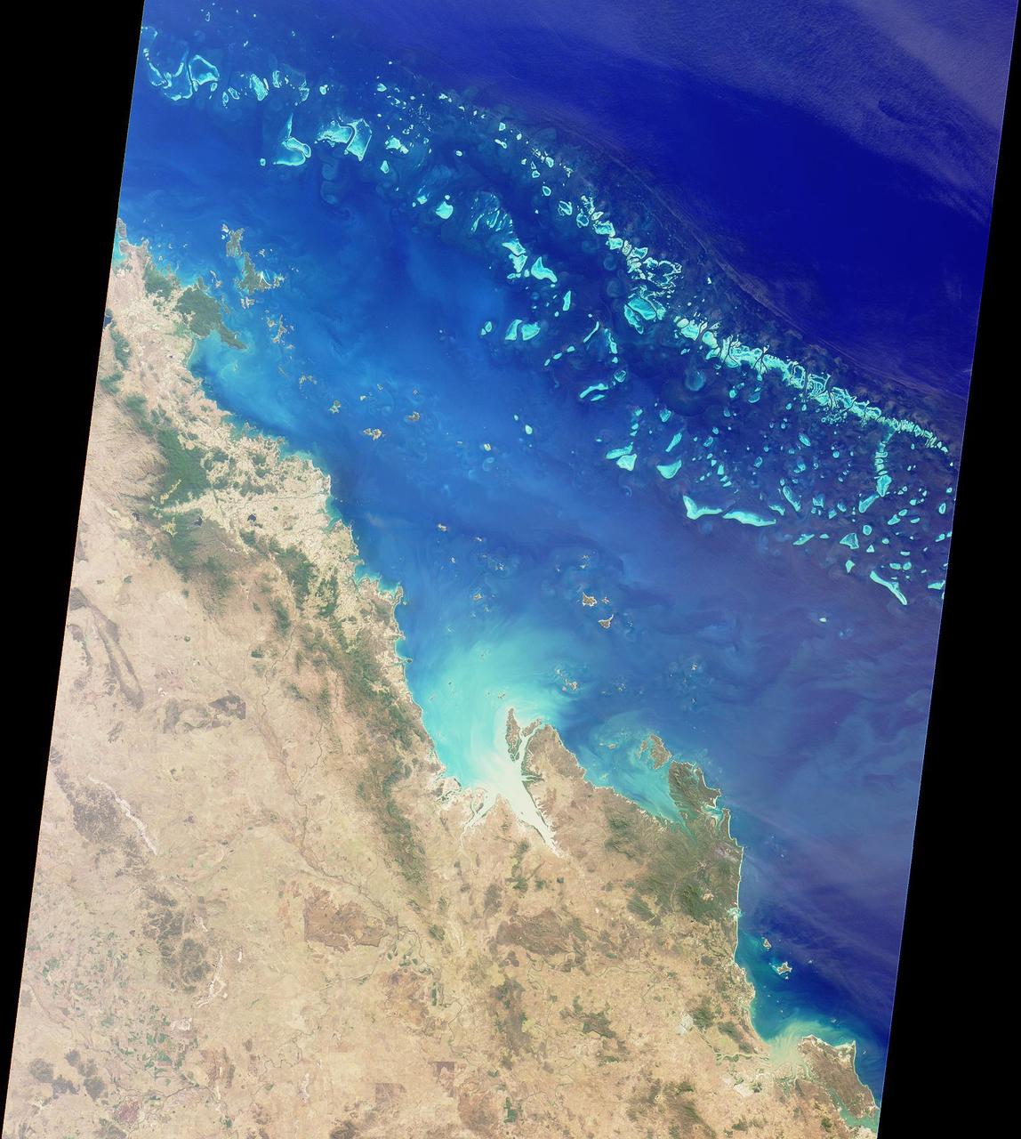
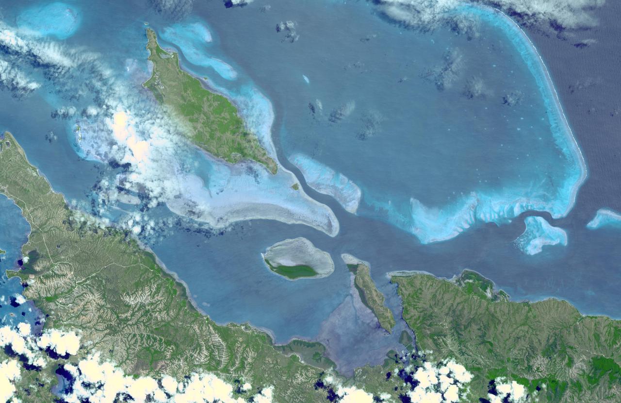
NASA image acquired May 10, 2001 In July 2008, the United Nations Educational, Scientific, and Cultural Organization (UNESCO) added 27 new areas to its list of World Heritage sites. One of those areas included the lagoons of New Caledonia. Some 1,200 kilometers (750 miles) east of Australia, this French-governed archipelago contains the world’s third-largest coral reef structure. The coral reefs enclose the waters near the islands in shallow lagoons of impressive biodiversity. On May 10, 2001, the Enhanced Thematic Mapper Plus on NASA’s Landsat 7 satellite captured this image of Île Balabio, off the northern tip of Grande Terra, New Caledonia’s main island. In this natural-color image, the islands appear in shades of green and brown—mixtures of vegetation and bare ground. The surrounding waters range in color from pale aquamarine to deep blue, and the color differences result from varying depths. Over coral reef ridges and sand bars, the water is shallowest and palest in color. Darker shades of blue characterize deeper waters. Reef-enclosed, shallow waters surround Île Balabio, and a larger, semi-enclosed lagoon appears immediately east of that island. Immediately north of Grande Terra, unenclosed, deeper waters predominate. The coral reefs around New Caledonia support an unusual diversity of species, including large numbers of predators and big fish, turtles, and the world’s third-largest dugong population. NASA image created by Jesse Allen, using Landsat data provided by the United States Geological Survey. Caption by Michon Scott. Instrument: Landsat 7 - ETM+ Credit: NASA/GSFC/Landsat <b><a href="http://www.nasa.gov/centers/goddard/home/index.html" rel="nofollow">NASA Goddard Space Flight Center</a></b> enables NASA’s mission through four scientific endeavors: Earth Science, Heliophysics, Solar System Exploration, and Astrophysics. Goddard plays a leading role in NASA’s accomplishments by contributing compelling scientific knowledge to advance the Agency’s mission. <b>Follow us on <a href="http://twitter.com/NASA_GoddardPix" rel="nofollow">Twitter</a></b> <b>Join us on <a href="http://www.facebook.com/pages/Greenbelt-MD/NASA-Goddard/395013845897?ref=tsd" rel="nofollow">Facebook</a></b>
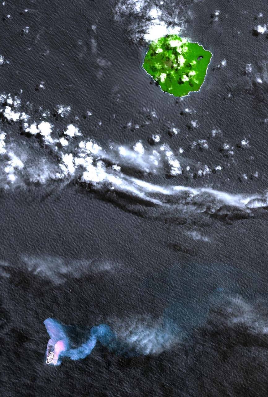
In the South Pacific, south of Late Island along the Tofua volcanic arc in Tonga, a new volcanic island Home Reef is being re-born. This image was acquired October 10, 2006 by NASA Terra spacecraft.
STS035-81-040 (2-10 Dec 1990) --- Numerous algae reefs are seen in Shark Bay, Western Australia, Australia (26.0S, 113.5E) especially in the southern portions of the bay. The south end is more saline because tidal flow in and out of the bay is restricted by sediment deposited at the north and central end of the bay opposite the mouth of the Wooramel River. This extremely arid region produces little sediment runoff so that the waters are very clear, saline and rich in algae.
STS032-520-014 (9-20 Jan. 1990) --- STS-32 astronauts took this 70mm scene showing phytoplankton oralgal bloom in the northwest Coral Sea. The Western Coral Sea and the Great Barrier Reef waters offshore Queensland, Australia are the sites of some of the larger concentrations or "blooms" of phytoplankton and algae in the open ocean. In the instance illustrated here, the leading edge of a probable concentration of algae or phytoplankton is seen as a light irregular line and sheen between the offshore Great Barrier Reef and the Queensland coast. Previous phytoplankton concentrations in this area have been reported by ships at sea as having formed floating mats as thick as two meters. This picture was used by the STS-32 astronauts at their Jan. 30, 1990 post-flight press conference.

STS072-727-085 (11-20 Jan. 1996) --- The northern third of the Great Barrier Reef stretches 650 kilometers (km) along the coast of Queensland from south of Cairns to past Princess Charlotte Bay at the base of the Cape York Peninsula. The predominant westerly waves of the ocean create shallower (lighter-colored) convex-eastward rims to coral atolls along the outer edge of the barrier reef. In contrast, islands within the lagoon show the effect of predominant southerly, more-or-less offshore winds. Arcuate clouds suggest that winds were offshore at the time the photograph was taken.
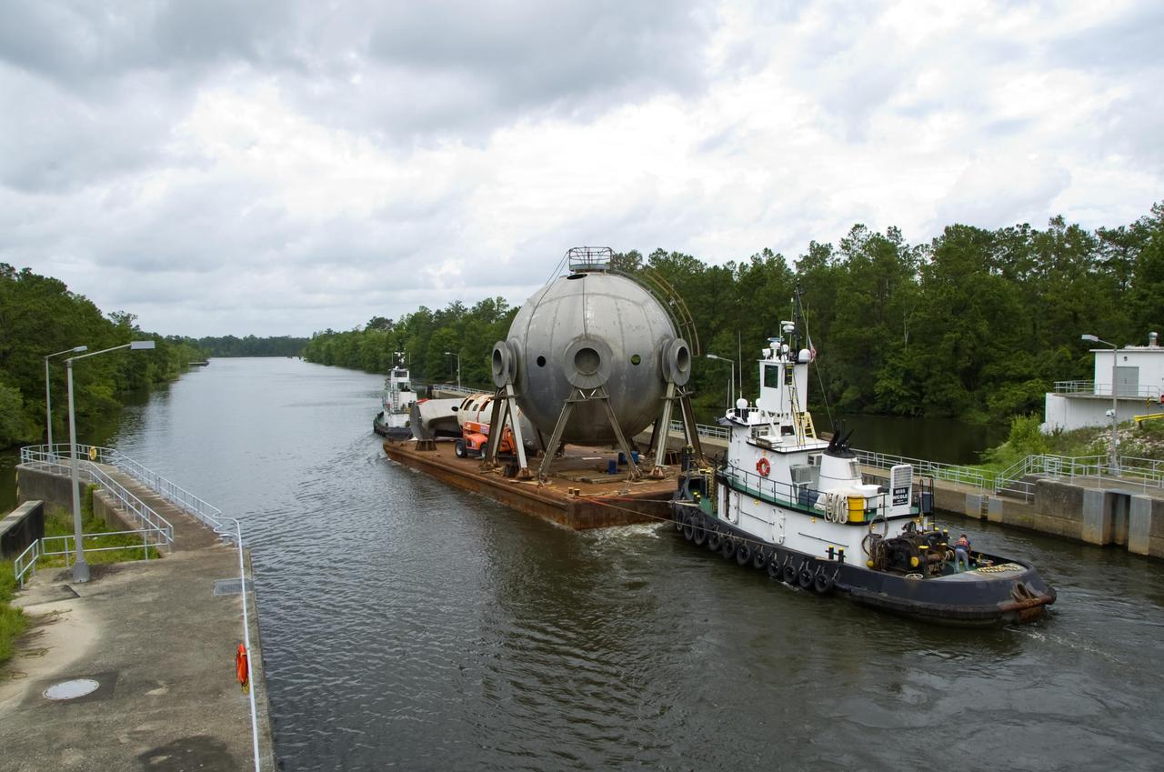
A 107,000-gallon liquid hydrogen sphere no longer needed at Stennis Space Center is barged through the facility locks June 21. The rocket engine test facility has teamed with the Mississippi Department of Marine Resource to place the sphere in offshore waters as an artificial reef.
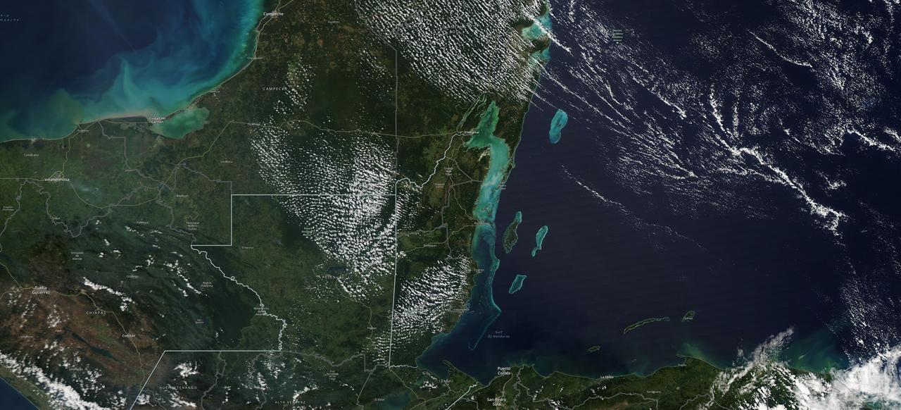
The Moderate Resolution Imaging Spectroradiometer (MODIS) instrument aboard NASA's Aqua satellite captured this image of the Yucatán Peninsula on Feb. 3, 2022. At the center is Belize, a country whose Caribbean coast is home to the Belize Barrier Reef Reserve System, which encompasses a vibrant network of marine environments that supports thousands of animal and plant species and drives Belize's largest industry, tourism. The barrier reef system is among about 1,200 UNESCO World Heritage sites around the world. In a paper published in November 2022 in Frontiers in Remote Sensing, researchers used data from Aqua MODIS to rank 24 protected marine areas off the Belizean coast based on the risks coral face from murky water and rising temperatures. The research also outlined how researchers at NASA's Jet Propulsion Laboratory in Southern California and counterparts in Belize used free, cloud-based data on Google Earth Engine in their analysis. Analyzing imagery from 2002 to 2022, researchers developed a coral vulnerability index – a score between 2 and 12 that characterizes the risk to coral, with higher scores signifying greater risk. Their findings could help management authorities protect the reefs from human impacts such as development, overfishing, pollution, and climate change. https://photojournal.jpl.nasa.gov/catalog/PIA25861

STS054-86-001 (13-19 Jan. 1993) --- This 70mm view shows a spectacular multiple spit on the coast of Brazil, about halfway between Rio de Janeiro and the mouth of the Amazon River. Over a few thousand years, according to NASA scientists, shifting regimes of wave and current patterns piled up sand onto a series of beach ridges and tidal lagoons. The present swirls of sediment along the coast evidently were derived from beach erosion, because streams flowing into the Atlantic contain dark, clear water. Offshore, reefs and sandbanks parallel the coast. The largest is the Recife da Pedra Grande (Big Rocks Reef).
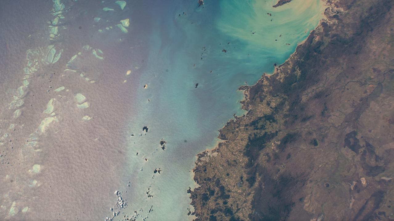
Cairns and Townsville area, on the northeast coast of Queensland, Australia (17.0S, 146.0E) is one of the best sport diving localities in the world where divers can explore the rich and varied flora and fauna of the nearby Great Barrier Reef. Onshore, the timbered foothills of the Great Dividing Range, seen as dark green areas, separate the semi arid interior of Queensland.
ISS009-E-23808 (20 September 2004) --- A fringing coral reef in the Red Sea is featured in this image photographed by an Expedition 9 crewmember on the International Space Station (ISS). The Sudanese coast of the Red Sea is a well known destination for divers due to clear water and abundance of coral reefs (or “shia’ab” in Arabic). According to NASA scientists studying the ISS imagery, reefs are formed primarily from precipitation of calcium carbonate by corals; massive reef structures are built over thousands of years of succeeding generations of coral. In the Red Sea, fringing reefs form on shallow shelves of less than 50 meters depth along the coastline. This photograph illustrates the intricate morphology of the reef system located along the coast between Port Sudan to the northwest and the Tokar River delta to the southeast. Close to shore, fringing reefs border the coastline. Farther offshore grows a larger, more complicated barrier reef structure. Different parts of the reef structure show up as variable shades of light blue. Deeper water channels (darker blue) define the boundaries for individual reefs within the greater barrier reef system. Such a complex pattern of reefs may translate into greater ecosystem diversity through a wide variety of local reef environments.
STS009-46-1856 (28 Nov-8 Dec 1983) --- East of the Australian state of Queensland lies the worlds largest reef. The Great Barrier Reef. A portion of the reef is seen. Although beautiful from space, coral reefs, channels, etc?, has long confounded navigators, mapmakers, and oceanographers.
Heron Island is located in Queensland, Australia, approximately 45 miles (72 kilometers) off the Australian mainland, to the northeast of Gladstone. Part of Australia's Great Barrier Reef, the island is an evergreen coral cay surrounded by Wistari coral reef. Although just 42 acres in size, the island is home to a large resort and the University of Queensland's Heron Island Research Station. The island is famous for diving and snorkeling and is a World Heritage-Listed Marine National Park. It is one of two locations on the Great Barrier Reef that are serving as bases for in-water validation activities for NASA's Coral Reef Airborne Laboratory (CORAL) mission, which is studying the condition and function of the Great Barrier Reef and selected reef systems worldwide using NASA's airborne Portable Remote Imaging Spectrometer (PRISM) instrument from an altitude of 28,000 feet (8,500 meters). The Advanced Spaceborne Thermal Emission and Reflection Radiometer (ASTER) instrument on NASA's Terra spacecraft acquired this image of Heron Island and its surroundings on December 22, 2001. The island appears at the left of the reef (Heron Reef) in the center of the image. Vegetation is red on the image. The image covers an area of 10.3 by 18.6 miles (16.5 by 30.0 kilometers), and is located at 23.5 degrees south, 151.9 degrees east. http://photojournal.jpl.nasa.gov/catalog/PIA20900
In this image, taken by NASA Terra spacecraft, six marine clusters represent the main diversity of coral reefs and associated ecosystems in the French Pacific Ocean archipelago of New Caledonia.
ISS010-E-09287 (3 December 2004) --- Howland Island, Oceania is featured in this digital image photographed by an Expedition 10 crewmember on the International Space Station (ISS). Howland Island is a United States possession located in the north Pacific between Australia and the Hawaiian Islands. Prior to 1890, organic nitrate (guano) was mined from the island by both the United States and the British. This tiny island is currently part of the US National Wildlife Refuge system, and provides nesting areas and forage for a variety of birds and marine wildlife. The island is composed of coral fragments and is surrounded by an active fringing reef. White breakers encircling the island indicate the position of the reef. Astronauts aboard the Space Station photograph numerous reefs around the world as part of a global mapping and monitoring program. High-resolution images such as this one are used to update geographic maps of reefs and islands, assess the health of reef ecosystems, and calculate bathymetry of the surrounding ocean bottom.
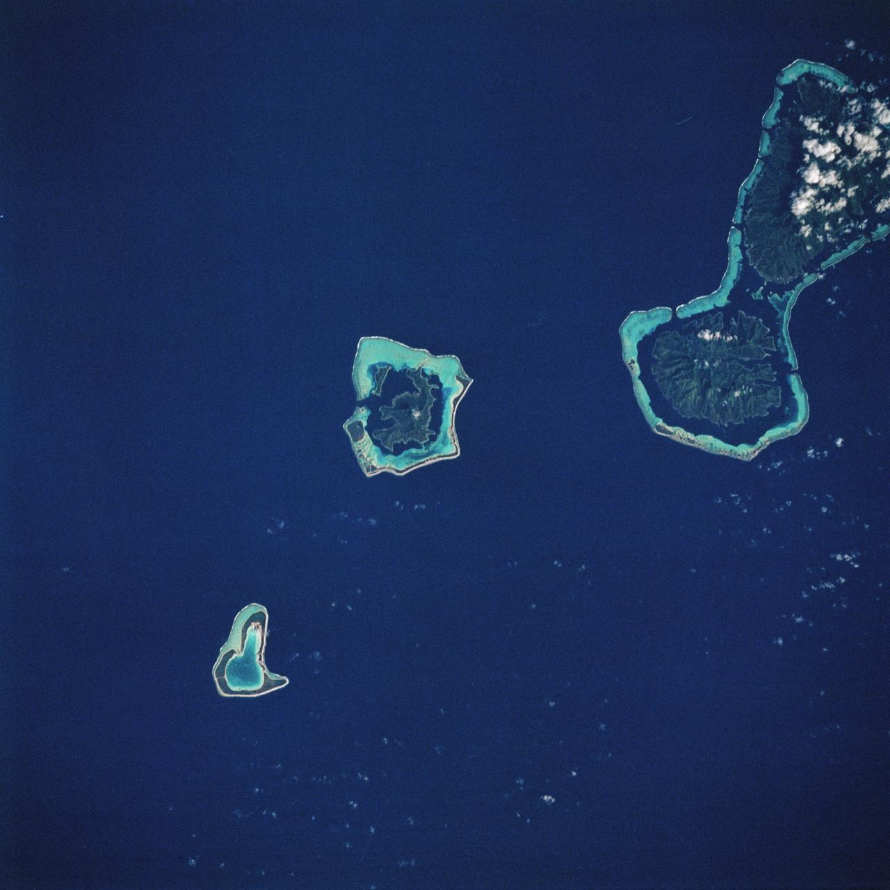
STS093-717-066 (23-27 July 1999) --- The STS-93 astronauts aboard the Space Shuttle Columbia took this picture featuring the Society Islands. Delicate coral reefs ring the islands of Bora Bora (top), Tahaa (center) and Raiatea (bottom). The Society Islands, which also include the island of Tahiti, are one of many archipelagoes that constitute French Polynesia in the central South Pacific. When the photo was taken, the shuttle was flying over a point located at 16.2 degrees south latitude and 151.8 degrees west longitude. Data back information on the 70mm listed the time and date as 23:36:16 GMT, July 25, 1999 (Orbit 45).
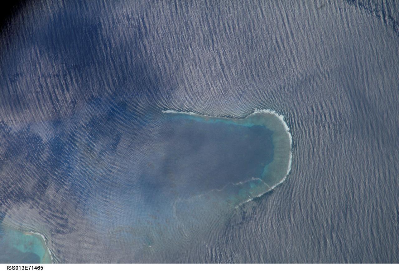
ISS013-E-71465 (27 Aug. 2006) --- Bajo Nuevo Reef in the western Caribbean Sea is featured in this image photographed by an Expedition 13 crewmember on the International Space Station. The Bajo Nuevo reef is approximately 26 kilometers long, comprising two separate U-shaped cays, with only tiny sandy islands associated with them. The eastern cay, shown in this image, encloses a lagoon. Protected from open-sea swells, the water surface is calmer and some back reef detail is visible within the lagoon. Cloud shadows darken the top left corner. The clearest feature is the broad pattern of swells which show two slightly different orientations, producing a tightly crossed pattern. These swells are oriented transverse to the wind direction and were probably set in motion by two different storms hundreds of kilometers east of the reef. A single irregular line of light color--also suggestive of surface oil--traces a path along the south side of the lagoon.

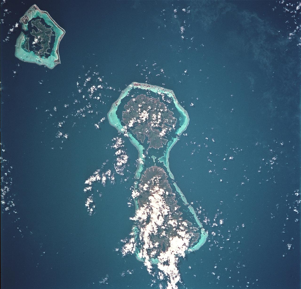
ISS006-E-22132 (January 2003) --- A portion of the Society Islands was captured with a digital still camera by one of the Expedition Six crewmembers on the International Space Station (ISS). The evolution of fringing reefs to atolls was captured in this one frame. As with the Hawaiian Islands, these volcanic hot spot islands become progressively older to the northwest. As these islands move away from their magma sources they erode and subside. The two large islands, Raiatea and Tahaa, share a single fringing reef. The next island to the northwest, Bora-Bora, consists of a highly eroded volcanic remnant with fringing reef. The last island, Tupai, has become an atoll with the central portion below sea level.
ISS016-E-019394 (30 Dec. 2007) --- Al Wadj Bank, Saudi Arabia is featured in this image photographed by an Expedition 16 crewmember on the International Space Station. Saudi Arabia boasts the most coral reefs of any Middle Eastern country, as it includes coastline along both the Red Sea and Gulf of Arabia. This high resolution image depicts a portion of the Al Wadj Bank, located along the northern Red Sea coast. Despite the relatively high salinity of Red Sea water (compared to other oceans), approximately 260 species of coral are found here, according to scientists. Large tracts of the Saudi Arabian coastline are undeveloped, and reefs in these areas are in generally good ecological health. However, reefs located near large urban centers like Jeddeh have suffered degradation due to land reclamation, pollution, and increased terrigeneous sediment input. The Al Wadj Bank includes a healthy and diverse reef system, extensive seagrass beds, and perhaps the largest population of dugong -- a marine mammal similar to the North American manatee -- in the eastern Red Sea. The portion of the Bank in this image illustrates the complex form and topography of the reef system. Several emergent islands (tan) - surrounded primarily by dark green seagrass - are visible, the largest located at top left. Only the islands are above the waterline -- over the reef structures the water color ranges from light teal (shallow) to turquoise (increasing depth). The southern edge of the reef is well indicated by the deep, dark blue water of the Red Sea at image top.
STS008-32-748 (30 Aug-5 Sept 1983) --- Bora-Bora, with its wide-fringing reef, stands out in the center of this photographed, taken over the Society Island chain from the Earth-orbiting Space Shuttle Challenger on its third spaceflight. In the upper left corner are the islands of Raiatea and Tahaa. The ancient volcano islands are very slowly sinking into the oceanic crust, while coral growth maintains a reef platform.
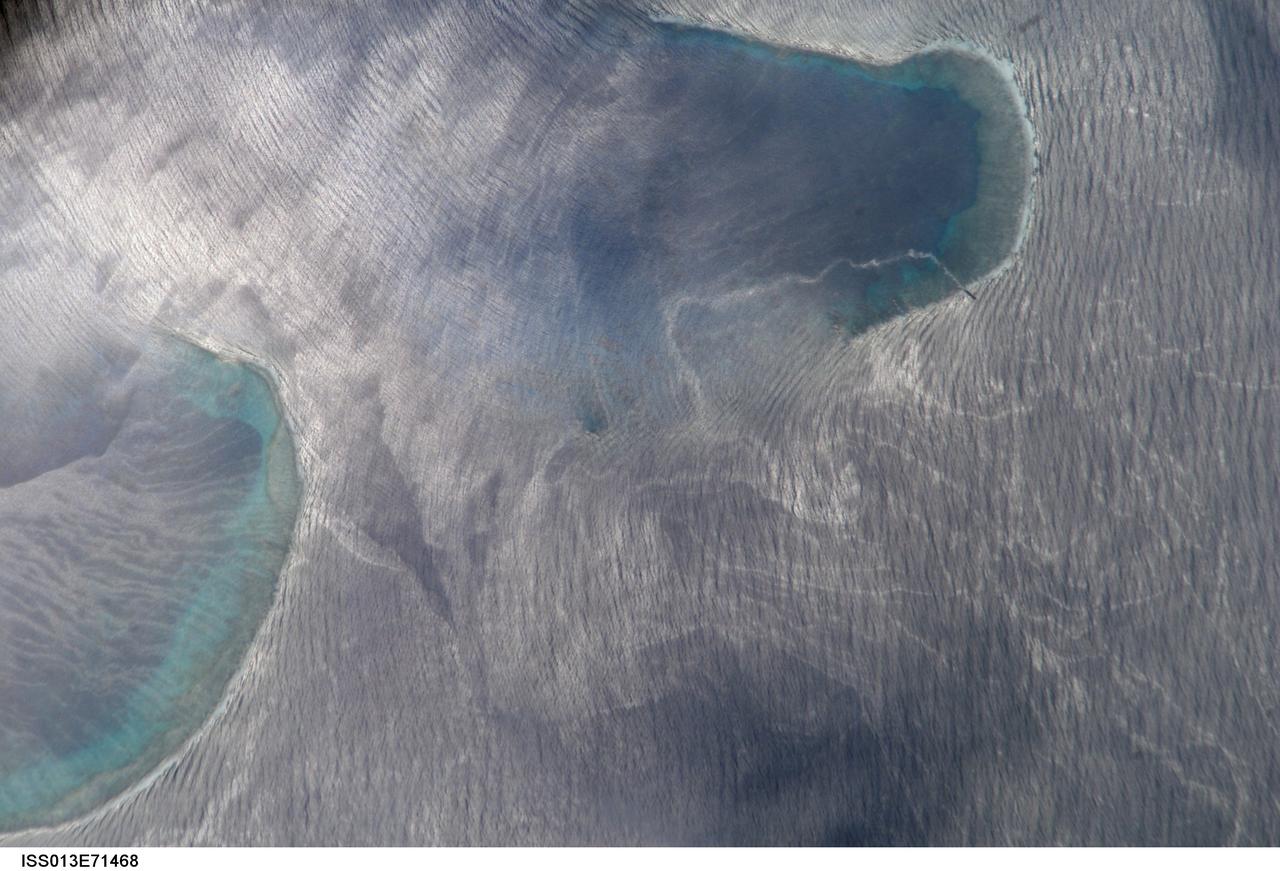
ISS013-E-71468 (27 Aug. 2006) --- Bajo Nuevo Reef in the western Caribbean Sea is featured in this image photographed by an Expedition 13 crewmember on the International Space Station. The Bajo Nuevo reef is approximately 26 kilometers long, comprising two separate U-shaped cays, with only tiny sandy islands associated with them. This detailed view reveals small, low islands that fringe the upwind side (image right) of the lagoon. These islands seem dwarfed by wave swells, which almost appear to wash over them. The clearest feature is the broad pattern of swells which show two slightly different orientations, producing a tightly crossed pattern. These swells are oriented transverse to the wind direction and were probably set in motion by two different storms hundreds of kilometers east of the reef. A single irregular line of light color--also suggestive of surface oil--traces a path along the south side of the lagoon.
iss068e004262 (Sept. 30, 2022) --- The eastern coast of Queensland, Australia, on the Great Barrier Reef is pictured from the International Space Station as it orbited 261 miles above the island continent.
iss070e025882 (Nov. 15, 2023) --- Looking southwest over the Far North region of Queensland, Australia, is the Great Barrier Reef in the Coral Sea and the Gulf of Carpentaria on the other side of the Far North.
iss061e025964 (Oct. 31, 2019) --- The French Polynesian island of Bora Bora, surrounded by the Bora Main Motu Reef, is pictured as the International Space Station orbited 257 miles above the South Pacific Ocean.

iss067e212950 (July 30, 2022) --- Scorpion Reef, north of the Mexican state of Yucatan, in the Gulf of Mexico is pictured from the International Space Station as it orbited 257 miles above.
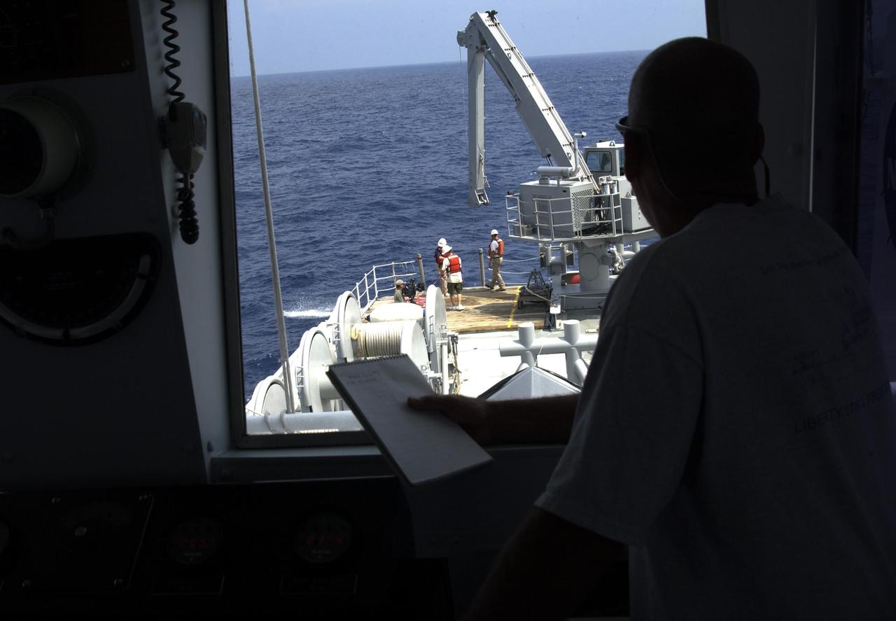
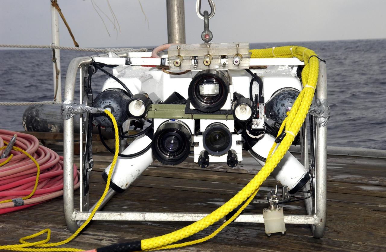
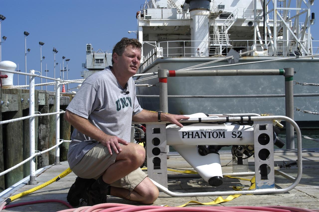
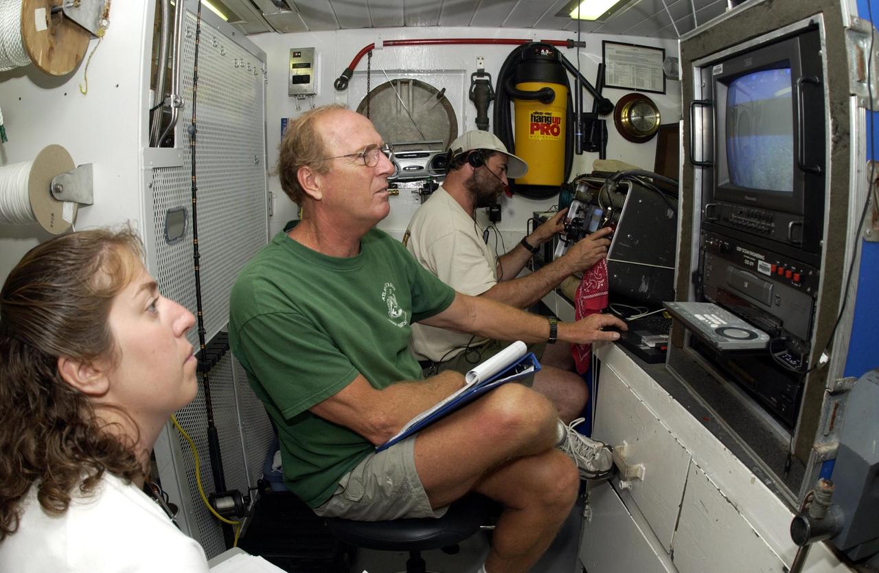
KENNEDY SPACE CENTER, FLA. - A view from inside the pilot house of the Liberty Star overlooks the stern where a team secures lines to underwater research equipment being used on an expedition to characterize the condition of the deep-sea coral reefs and reef fish populations in the Oculina Banks. The banks are a marine protected area, 20 miles offshore of the east coast of Florida. The equipment includes an underwater robot, a seafloor sampler, and the Passive Acoustic Monitoring System (PAMS), originally developed by NASA to monitor the impact of rocket launches on wildlife refuge lagoons at KSC. The research is sponsored by NOAA Fisheries. The ship departed from Port Canaveral April 29 and will return May 9.
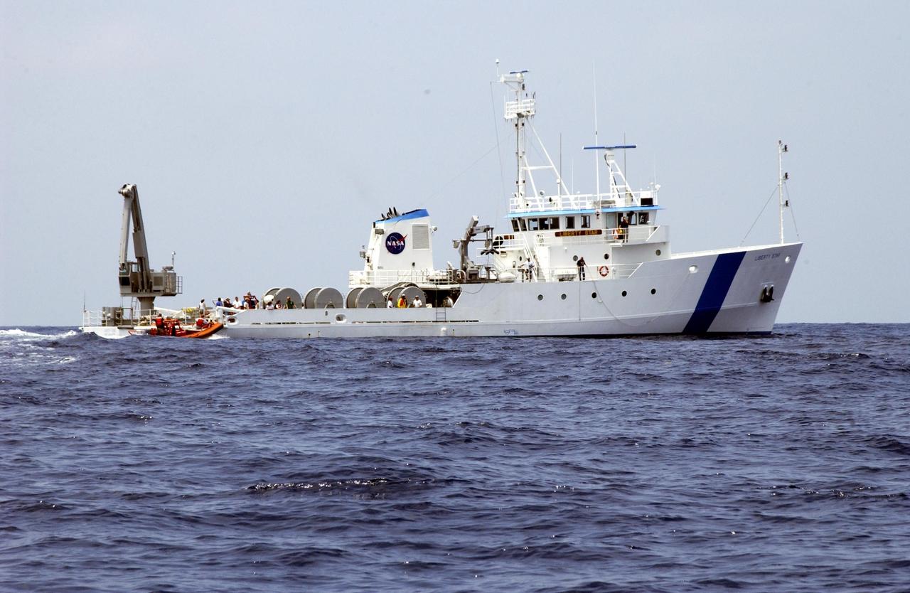
KENNEDY SPACE CENTER, FLA. - The Liberty Star makes its way along the Oculina Banks, a marine protected area, 20 miles offshore of the east coast of Florida. The ship is taking part in an undersea expedition to characterize the condition of the deep-sea coral reefs and reef fish populations in the Oculina Banks. Equipment being used for the research includes an underwater robot, a seafloor sampler, and the Passive Acoustic Monitoring System (PAMS), originally developed by NASA to monitor the impact of rocket launches on wildlife refuge lagoons at KSC. The research is sponsored by NOAA Fisheries. The ship departed from Port Canaveral April 29 and will return May 9.
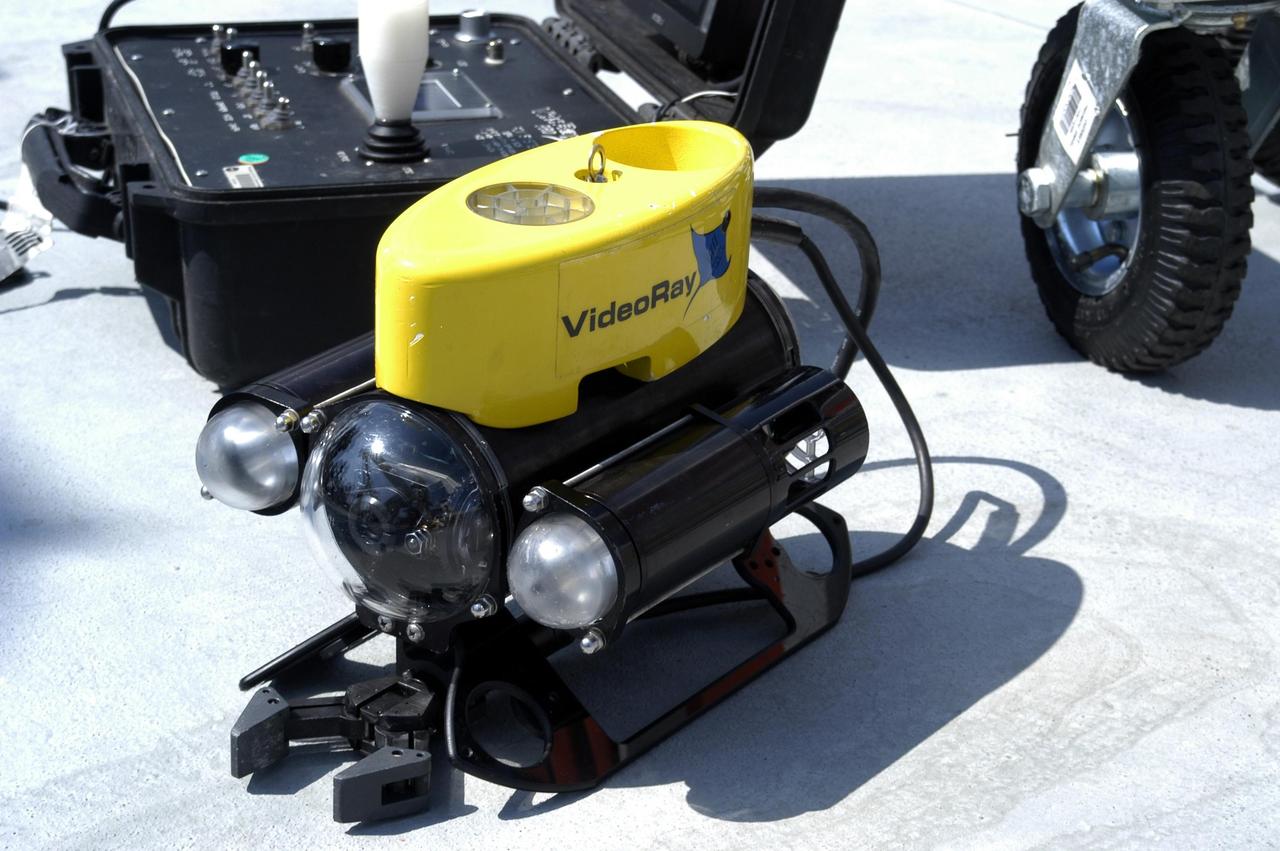
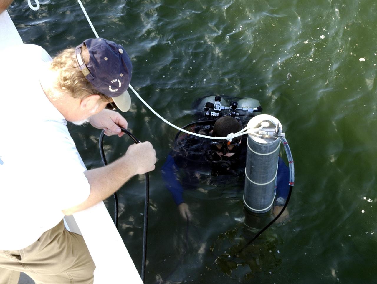
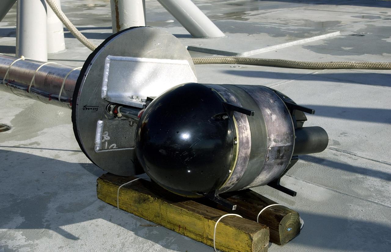
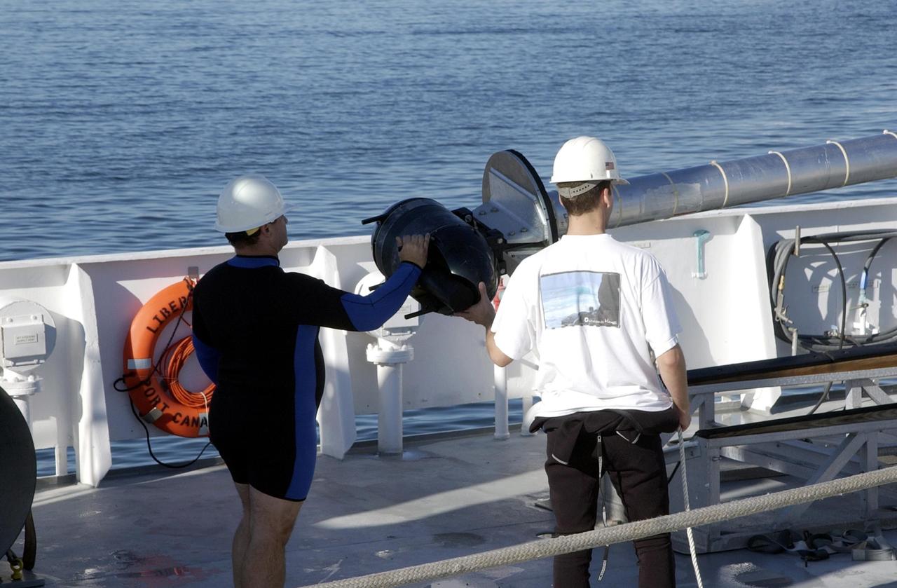
KENNEDY SPACE CENTER, FLA. - Pictured is a piece of equipment that will be used on an undersea expedition to characterize the condition of the deep-sea coral reefs and reef fish populations in the Oculina Banks, a marine protected area, 20 miles offshore of the east coast of Florida. Scientists on the team will be deploying an underwater robot, a seafloor sampler, and the Passive Acoustic Monitoring System (PAMS). Dr. Grant Gilmore was co-principle investigator of the PAMS, originally developed by NASA to monitor the impact of rocket launches on wildlife refuge lagoons at KSC. The research is sponsored by NOAA Fisheries and will take place onboard the Liberty Star. The ship departed from Port Canaveral April 29 and will return May 9.
KENNEDY SPACE CENTER, FLA. - Underwater equipment is checked on the deck of the Liberty Star, which will be the site of an undersea expedition to characterize the condition of the deep-sea coral reefs and reef fish populations in the Oculina Banks, a marine protected area, 20 miles offshore of the east coast of Florida. A team of scientists will deploy an underwater robot, a seafloor sampler, and the Passive Acoustic Monitoring System (PAMS), originally developed by NASA to monitor the impact of rocket launches on wildlife refuge lagoons at KSC. The research is sponsored by NOAA Fisheries. The ship departed from Port Canaveral April 29 and will return May 9.
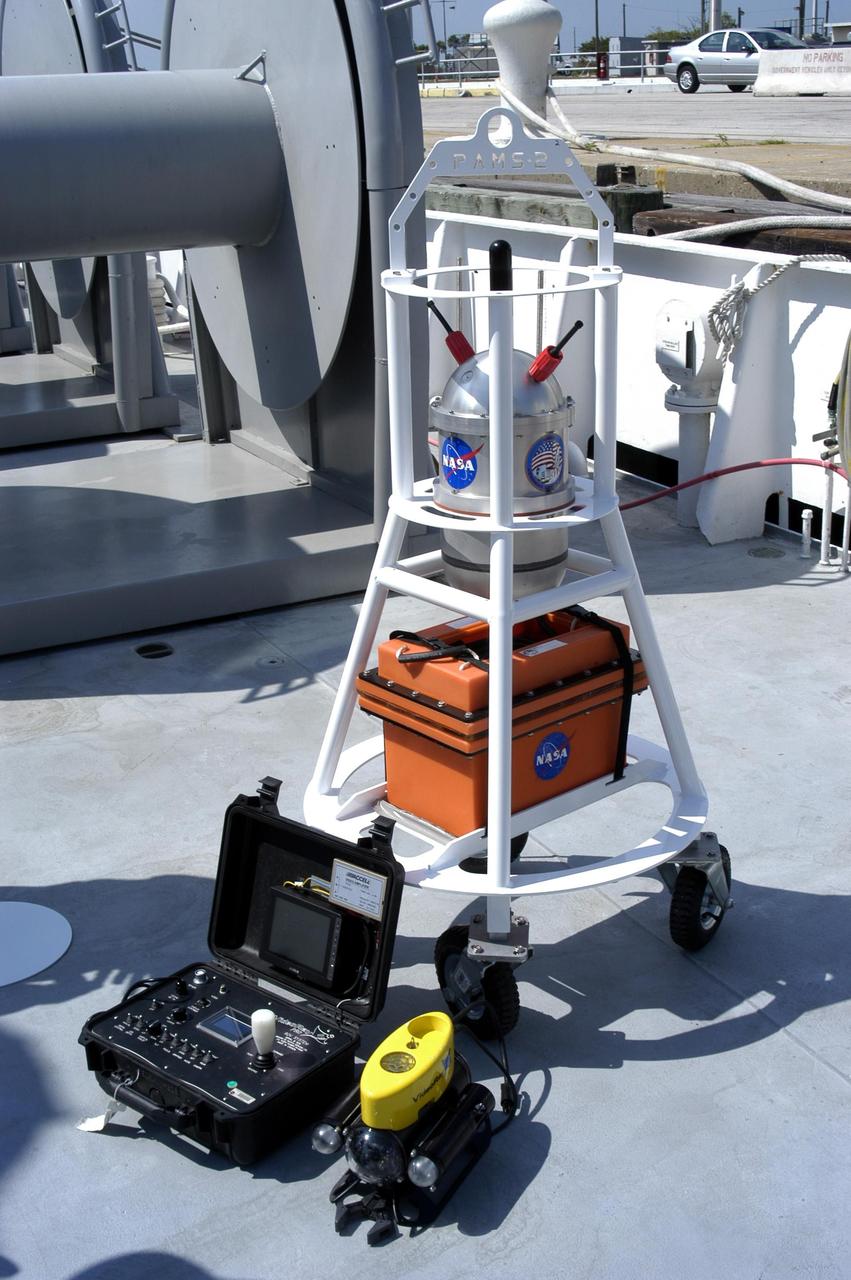
KENNEDY SPACE CENTER, FLA. - Pictured is equipment that will be used on an undersea expedition to characterize the condition of the deep-sea coral reefs and reef fish populations in the Oculina Banks, a marine protected area, 20 miles offshore of the east coast of Florida. Scientists on the team will be deploying an underwater robot, a seafloor sampler, and the Passive Acoustic Monitoring System (PAMS). Dr. Grant Gilmore was co-principle investigator of the PAMS, originally developed by NASA to monitor the impact of rocket launches on wildlife refuge lagoons at KSC. The research is sponsored by NOAA Fisheries and will take place onboard the Liberty Star. The ship departed from Port Canaveral April 29 and will return May 9.

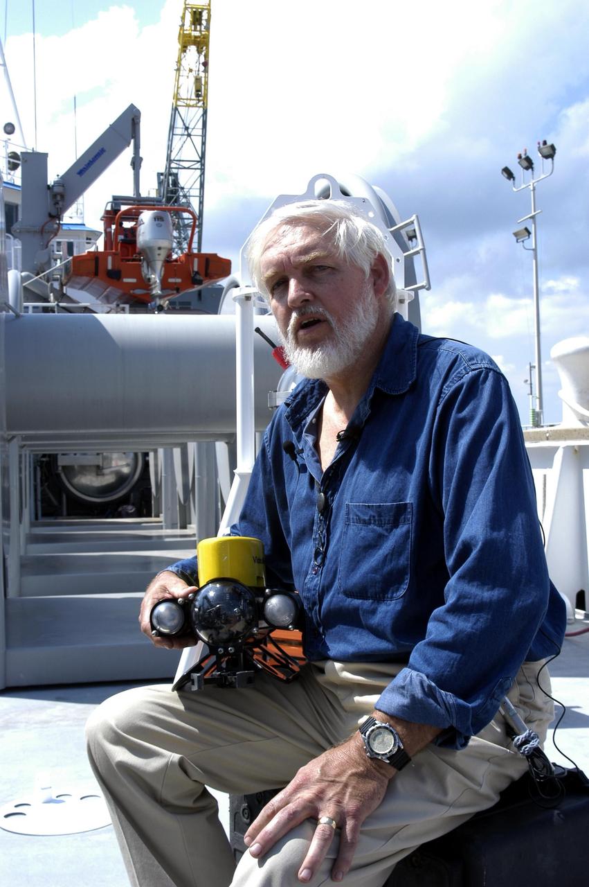
KENNEDY SPACE CENTER, FLA. - John Reed, co-principal investigator, Harbor Branch Oceanographic Institution, points to the Oculina Banks, a marine protected area, 20 miles offshore of the east coast of Florida. A team of scientists will deploy an underwater robot, a seafloor sampler, and the Passive Acoustic Monitoring System (PAMS), on an undersea expedition to characterize the condition of the deep-sea coral reefs and reef fish populations in the Oculina Banks. The PAMS was originally developed by NASA to monitor the impact of rocket launches on wildlife refuge lagoons at KSC. The research is sponsored by NOAA Fisheries and will take place onboard the Liberty Star. The ship departed from Port Canaveral April 29 and will return May 9.
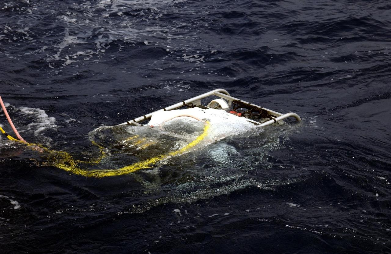
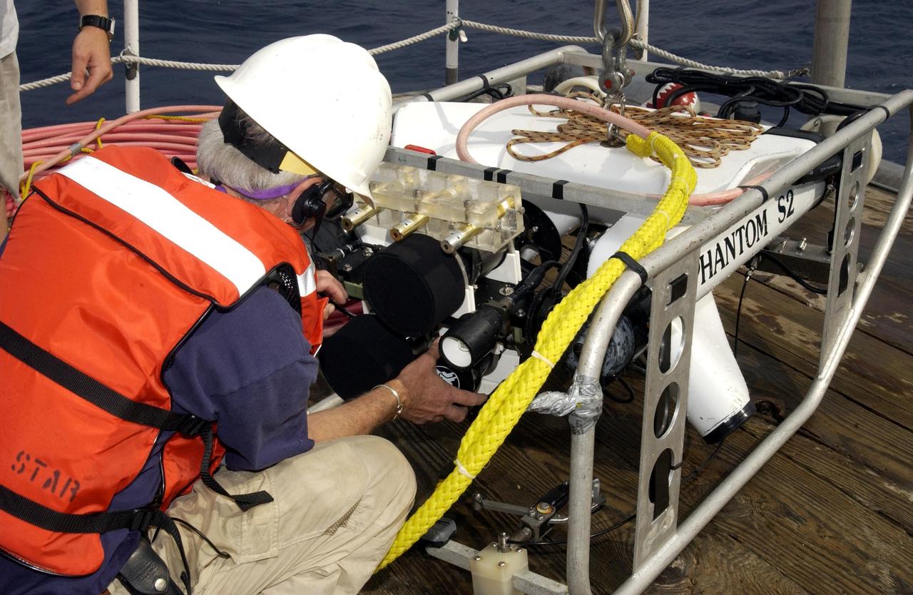
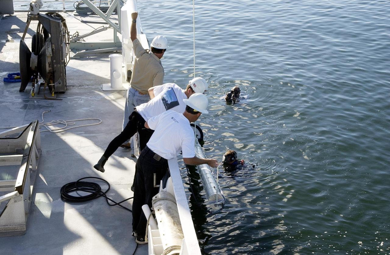
KENNEDY SPACE CENTER, FLA. - Underwater research equipment slowly sinks into the water. An undersea expedition is underway to characterize the condition of the deep-sea coral reefs and reef fish populations in the Oculina Banks, a marine protected area, 20 miles offshore of the east coast of Florida. The equipment includes an underwater robot, a seafloor sampler, and the Passive Acoustic Monitoring System (PAMS), originally developed by NASA to monitor the impact of rocket launches on wildlife refuge lagoons at KSC. The research is sponsored by NOAA Fisheries and will take place onboard the Liberty Star. The ship departed from Port Canaveral April 29 and will return May 9.
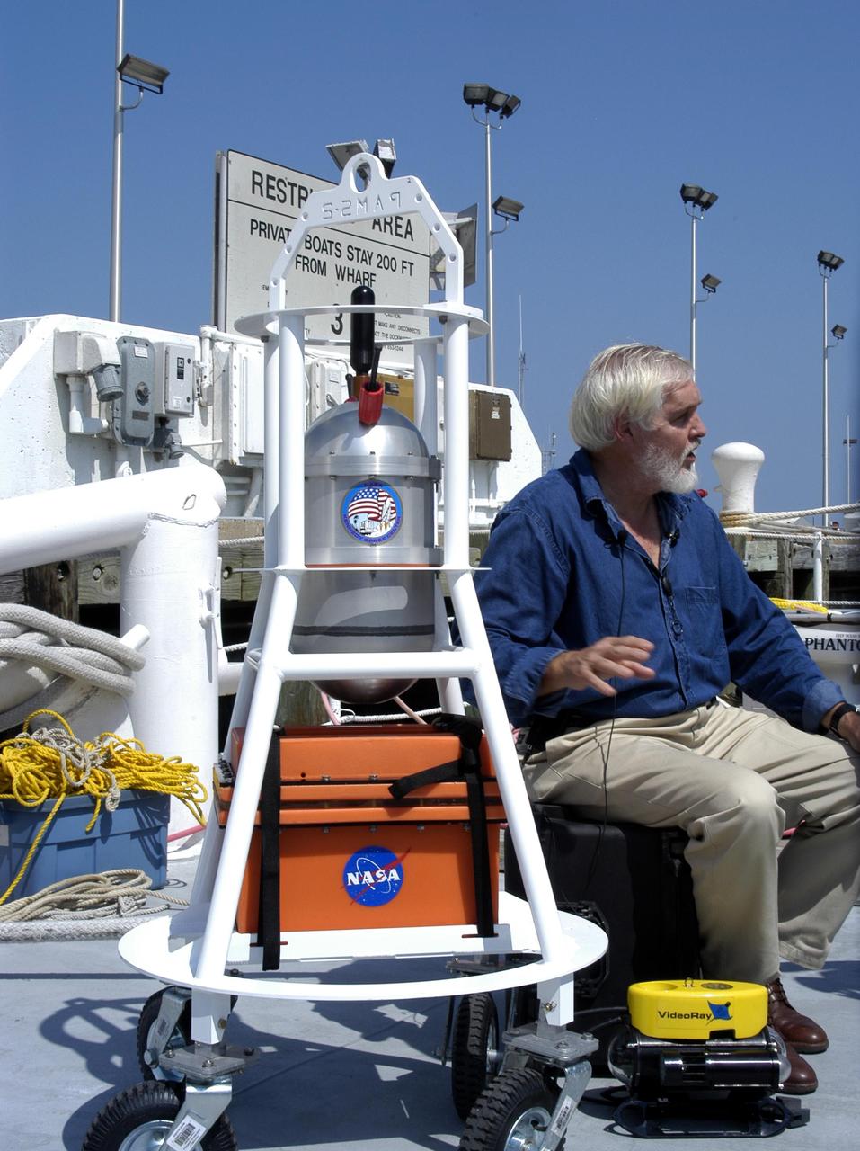
KENNEDY SPACE CENTER, FLA. - Dr. Grant Gilmore sits alongside some of the equipment that will be used on an undersea expedition to characterize the condition of the deep-sea coral reefs and reef fish populations in the Oculina Banks, a marine protected area, 20 miles offshore of the east coast of Florida. Scientists on the team will be deploying an underwater robot, a seafloor sampler, and the Passive Acoustic Monitoring System (PAMS). Gilmore is co-principle investigator of the PAMS, originally developed by NASA to monitor the impact of rocket launches on wildlife refuge lagoons at KSC. The research is sponsored by NOAA Fisheries and will take place onboard the Liberty Star. The ship departed from Port Canaveral April 29 and will return May 9.

KENNEDY SPACE CENTER, FLA. - A team onboard the Liberty Star, the NASA Space Shuttle support ship operated by United Space Alliance, get ready to lower underwater research equipment into the water. An undersea expedition is underway to characterize the condition of the deep-sea coral reefs and reef fish populations in the Oculina Banks, a marine protected area, 20 miles offshore of the east coast of Florida. The equipment includes an underwater robot, a seafloor sampler, and the Passive Acoustic Monitoring System (PAMS), originally developed by NASA to monitor the impact of rocket launches on wildlife refuge lagoons at KSC. The research is sponsored by NOAA Fisheries. The ship departed from Port Canaveral April 29 and will return May 9.
STS054-74-049 (13-19 Jan. 1993) --- St. Croix is the largest, and most industrial of the U.S. Virgin Islands. This photograph captures St. Croix's features in great detail. The large industrial complex in the middle of the southern shore is the world's largest petroleum refinery. The main city, Christiansted, can be seen across the island on the north shore. The reefs around the eastern end of St. Croix are preserved as a submarine national park -- Buck Island Reef National Park -- around the small island off the north shore of the eastern end of St. Croix.

KENNEDY SPACE CENTER, FLA. - Underwater research equipment is prepared for immersion from the Liberty Star, the NASA Space Shuttle support ship operated by United Space Alliance. It is being used on an undersea expedition to characterize the condition of the deep-sea coral reefs and reef fish populations in the Oculina Banks, a marine protected area, 20 miles offshore of the east coast of Florida. The equipment includes an underwater robot, a seafloor sampler, and the Passive Acoustic Monitoring System (PAMS), originally developed by NASA to monitor the impact of rocket launches on wildlife refuge lagoons at KSC. The research is sponsored by NOAA Fisheries. The ship departed from Port Canaveral April 29 and will return May 9.
KENNEDY SPACE CENTER, FLA. - Underwater equipment sits on the deck of the Liberty Star, which will be the site of an undersea expedition to characterize the condition of the deep-sea coral reefs and reef fish populations in the Oculina Banks, a marine protected area, 20 miles offshore of the east coast of Florida. A team of scientists will deploy an underwater robot, a seafloor sampler, and the Passive Acoustic Monitoring System (PAMS), originally developed by NASA to monitor the impact of rocket launches on wildlife refuge lagoons at KSC. The research is sponsored by NOAA Fisheries. The ship departed from Port Canaveral April 29 and will return May 9.
KENNEDY SPACE CENTER, FLA. - A view inside the pilot house of the Liberty Star. The ship is taking part in an undersea expedition to characterize the condition of the deep-sea coral reefs and reef fish populations in the Oculina Banks. The banks are a marine protected area, 20 miles offshore of the east coast of Florida. The equipment includes an underwater robot, a seafloor sampler, and the Passive Acoustic Monitoring System (PAMS), originally developed by NASA to monitor the impact of rocket launches on wildlife refuge lagoons at KSC. The research is sponsored by NOAA Fisheries. The ship departed from Port Canaveral April 29 and will return May 9.

ISS040E112662 (08/30/2014) ---- Cancún, Mexico. A long lens was used by astronauts aboard the International Space Station to take this image, and it highlights many natural and built features. The street pattern of Mexico’s tourist mecca, Cancún, contrasts with the waterways of the marinas that open into the bay and the lagoons. Brilliant blue water over coral reefs contrast with the dark waters of inland lagoons. The reefs are the second largest reef system on Earth, and draw tourists from all over the world. The wide, well developed beach on the gulf coast (image upper right) is the result of vigorous wave energy; the white sand makes the beach easily visible from space. But wave energy is reduced along Cancún’s protected shoreline (image center) and the beaches are thin or non-existant. Fair-weather cumulus clouds are scattered across the image top left. To shoot crisp mages with long lenses, astronaut photographers must learn to brace themselves against the ISS bulkhead to prevent any slight shaking that would blur or “smear” the picture. Counterintuitively, they then need to move the camera carefully retaining the target at the same point in the viewfinder (the landscape moves across the viewfinder quickly with long lenses). This is called tracking the target and requires good coordination by the photographer—again, to prevent blurring. Shorter lenses do not require this skill because the image appears to pass more slowly across the viewfinder.
ISS043E182498 (05/08/2015) --- Expedition 43 Flight Engineer Scott Kelly tweeted this view of an American southwest section of the San Rafael Reef, Utah. Kelly added this comment to the tweet: "The rising sun casts shadows upon the US #SouthWest this morning creating a striking image. #YearInSpace".

iss071e378497 (July 21, 2024) -- The Quirimbas Islands lie in the western Indian Ocean off the coast of Mozambique. The archipelago consists of 32 islands, partially linked to the coastline by coral reefs, mangroves, and sand bars. As the International Space Station orbited 262 miles above, NASA astronaut Matthew Dominick captured this photo.

iss071e009021 (April 15, 2024) -- The Zapata Peninsula on the southern coast of Cuba is pictured from the International Space Station as it orbited nearly 260 miles above. Both a Biosphere Reserve and National Park, it's home to diverse ecosystems, including coral reefs in the cove of the Caribbean Sea.
ISS005-E-13929 (12 September 2002) --- Pearl and Hermes Reef, northwest Hawaii, are featured in this image photographed by an Expedition 5 crewmember onboard the International Space Station (ISS). A new technique developed by NOAA scientists has made it possible to plot the depths of lagoon features using digital astronaut photography from the ISS.
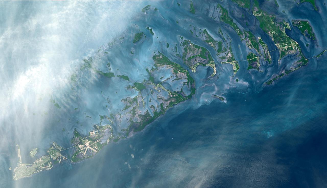
The Florida Keys are a chain of islands, islets and reefs extending from Virginia Key to the Dry Tortugas for about 309 kilometers (192 miles). The keys are chiefly limestone and coral formations. The larger islands of the group are Key West (with its airport), Key Largo, Sugarloaf Key, and Boca Chica Key. A causeway extends from the mainland to Key West. This image was acquired on October 28, 2001, by the Advanced Spaceborne Thermal Emission and Reflection Radiometer (ASTER) on NASA's Terra satellite. With its 14 spectral bands from the visible to the thermal infrared wavelength region, and its high spatial resolution of 15 to 90 meters (about 50 to 300 feet), ASTER images Earth to map and monitor the changing surface of our planet. http://photojournal.jpl.nasa.gov/catalog/PIA03890
KENNEDY SPACE CENTER, FLA. - Onboard the Liberty Star, the NASA Space Shuttle support ship operated by United Space Alliance, .Dr. Grant Gilmore holds some of the equipment to be used on an undersea expedition. Gilmore is co-principle investigator of the Passive Acoustic Monitoring System (PAMS), part of the equipment. NASA/KSC is participating in the expedition to characterize the condition of the deep-sea coral reefs and reef fish populations in the Oculina Banks, a marine protected area, 20 miles offshore of the east coast of Florida. Scientists on the team will be deploying an underwater robot, a seafloor sampler, and the PAMS, originally developed by NASA to monitor the impact of rocket launches on wildlife refuge lagoons at KSC. The research is sponsored by NOAA Fisheries. The ship departed from Port Canaveral April 29 and will return May 9.
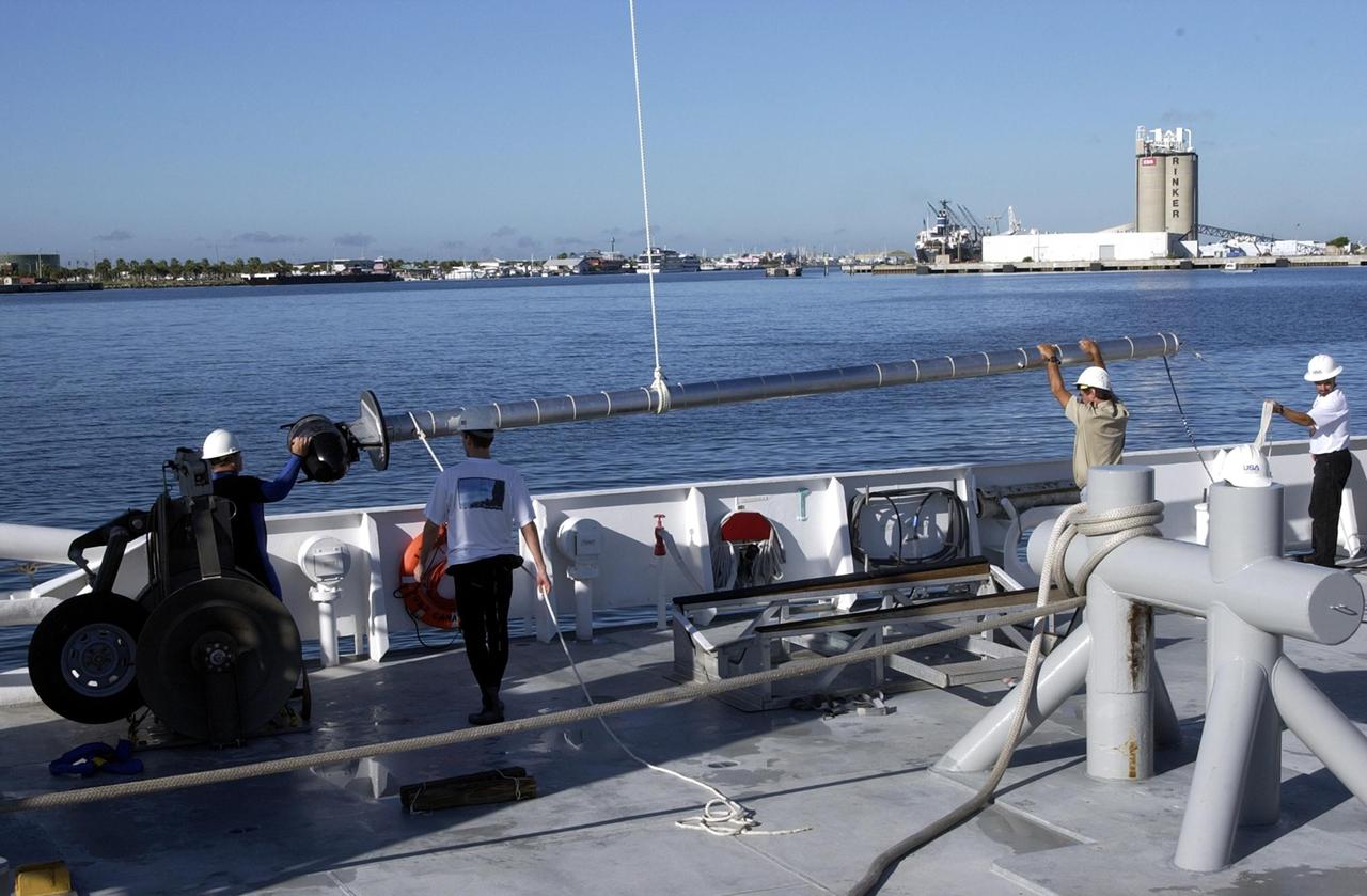
KENNEDY SPACE CENTER, FLA. -- Workers on the deck of the Liberty Star, one of NASA's solid rocket booster retrieval ships, help guide sonar mapping equipment toward the side of the ship. The equipment will be attached to the ship's hull for an eight-day expedition surveying deep-water coral reefs on the Oculina Banks off eastern Florida. NASA joins the National Oceanic and Atmospheric Administration (NOAA) and other ocean scientists for the sophisticated mapping system that will provide the first high-resolution, three-dimensional map of the Oculina Banks. The survey results are expected to guide another expedition in Spring 2003, using NASA's ship, when the reef fish spawn. Also used will be NASA's underwater robot and an acoustic hydrophone system for listening to fish and vessel noise. Dive sites will be chosen based on the new charts.
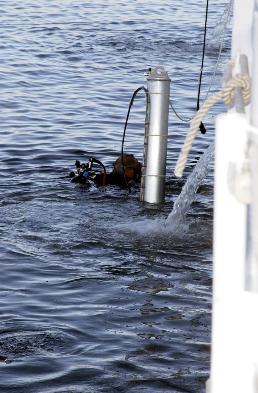
KENNEDY SPACE CENTER, FLA. -- A diver helps lower sonar mapping equipment into the water alongside the Liberty Star, one of NASA's solid rocket booster retrieval ships. The equipment will be attached to the ship's hull for an eight-day expedition surveying deep-water coral reefs on the Oculina Banks off eastern Florida. NASA joins the National Oceanic and Atmospheric Administration (NOAA) and other ocean scientists for the sophisticated mapping system that will provide the first high-resolution, three-dimensional map of the Oculina Banks. The survey results are expected to guide another expedition in Spring 2003, using NASA's ship, when the reef fish spawn. Also used will be NASA's underwater robot and an acoustic hydrophone system for listening to fish and vessel noise. Dive sites will be chosen based on the new charts.
KENNEDY SPACE CENTER, FLA. -- Workers on the deck of the Liberty Star, one of NASA's solid rocket booster retrieval ships, as well as divers in the water, help lower sonar mapping equipment alongside the ship. The equipment will be attached to the ship's hull for an eight-day expedition surveying deep-water coral reefs on the Oculina Banks off eastern Florida. NASA joins the National Oceanic and Atmospheric Administration (NOAA) and other ocean scientists for the sophisticated mapping system that will provide the first high-resolution, three-dimensional map of the Oculina Banks. The survey results are expected to guide another expedition in Spring 2003, using NASA's ship, when the reef fish spawn. Also used will be NASA's underwater robot and an acoustic hydrophone system for listening to fish and vessel noise. Dive sites will be chosen based on the new charts.
KENNEDY SPACE CENTER, FLA. -- A diver helps lower sonar mapping equipment into the water alongside the Liberty Star, one of NASA's solid rocket booster retrieval ships. The equipment will be attached to the ship's hull for an eight-day expedition surveying deep-water coral reefs on the Oculina Banks off eastern Florida. NASA joins the National Oceanic and Atmospheric Administration (NOAA) and other ocean scientists for the sophisticated mapping system that will provide the first high-resolution, three-dimensional map of the Oculina Banks. The survey results are expected to guide another expedition in Spring 2003, using NASA's ship, when the reef fish spawn. Also used will be NASA's underwater robot and an acoustic hydrophone system for listening to fish and vessel noise. Dive sites will be chosen based on the new charts.
KENNEDY SPACE CENTER, FLA. - Andrew Shepard, expedition leader, National Undersea Research Center, University of North Carolina at Wilmington, N. Car., poses on deck of the Liberty Star with some of the equipment to be used in the Oculina Banks project. The ship will be the site of an undersea expedition to characterize the condition of the deep-sea coral reefs and reef fish populations in the Oculina Banks, a marine protected area, 20 miles offshore of the east coast of Florida. He and other scientists will be deploying an underwater robot, a seafloor sampler, and the Passive Acoustic Monitoring System (PAMS). Dr. Grant Gilmore was co-principle investigator of the PAMS, originally developed by NASA to monitor the impact of rocket launches on wildlife refuge lagoons at KSC. The research is sponsored by NOAA Fisheries. The ship departed from Port Canaveral April 29 and will return May 9.
KENNEDY SPACE CENTER, FLA. - John Reed, co-principal investigator, Harbor Branch Oceanographic Institution, checks out equipment on the Liberty Star, which will be the site of an undersea expedition to characterize the condition of the deep-sea coral reefs and reef fish populations in the Oculina Banks, a marine protected area, 20 miles offshore of the east coast of Florida. He and other scientists will be deploying an underwater robot, a seafloor sampler, and the Passive Acoustic Monitoring System (PAMS). Dr. Grant Gilmore was co-principle investigator of the PAMS, originally developed by NASA to monitor the impact of rocket launches on wildlife refuge lagoons at KSC. The research is sponsored by NOAA Fisheries. The ship departed from Port Canaveral April 29 and will return May 9.
KENNEDY SPACE CENTER, FLA. -- Sonar mapping equipment lies on the deck of the Liberty Star, one of NASA's solid rocket booster retrieval ships. The equipment will be attached to the ship's hull for an eight-day expedition surveying deep-water coral reefs on the Oculina Banks off eastern Florida. NASA joins the National Oceanic and Atmospheric Administration (NOAA) and other ocean scientists for the sophisticated mapping system that will provide the first high-resolution, three-dimensional map of the Oculina Banks. The survey results are expected to guide another expedition in Spring 2003, using NASA's ship, when the reef fish spawn. Also used will be NASA's underwater robot and an acoustic hydrophone system for listening to fish and vessel noise. Dive sites will be chosen based on the new charts.
KENNEDY SPACE CENTER, FLA. -- Workers on the deck of the Liberty Star, one of NASA's solid rocket booster retrieval ships, oversee the lifting of sonar mapping equipment from the deck toward the side of the ship. The equipment will be attached to the ship's hull for an eight-day expedition surveying deep-water coral reefs on the Oculina Banks off eastern Florida. NASA joins the National Oceanic and Atmospheric Administration (NOAA) and other ocean scientists for the sophisticated mapping system that will provide the first high-resolution, three-dimensional map of the Oculina Banks. The survey results are expected to guide another expedition in Spring 2003, using NASA's ship, when the reef fish spawn. Also used will be NASA's underwater robot and an acoustic hydrophone system for listening to fish and vessel noise. Dive sites will be chosen based on the new charts.
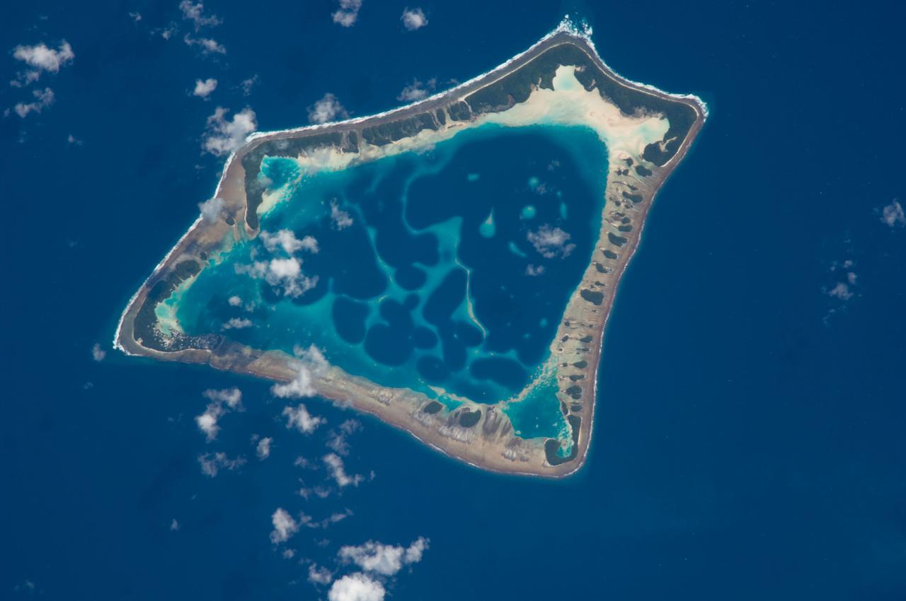
ISS018-E-018129 (6 Jan. 2009) --- Atafu Atoll in the Southern Pacific Ocean is featured in this image photographed by an Expedition 18 crewmember on the International Space Station. At roughly eight kilometers wide, Atafu Atoll is the smallest of three atolls (with Nukunonu and Fakaofo atolls to the southeast, not shown) comprising the Tokelau Islands group located in the southern Pacific Ocean. Swains Island to the south (not shown) is also considered part of the Tokelau group. The political entity of Tokelau is currently a territory of New Zealand. In recent years, public referendums on independence within the islands have been held, but have not received sufficient support to move forward. The primary settlement on Atafu is a village located at the northwestern corner of the atoll ? indicated by an area of light gray dots in this photograph. The typical ring shape of the atoll is the result of coral reefs building up around a former volcanic island. Over geologic time, the central volcano has subsided beneath the water surface, leaving the fringing reefs and a central lagoon that contains submerged coral reefs. Erosion and soil development on the surfaces of the exposed fringing reefs has lead to formation of tan to light brown beach deposits (southern and western sides of the atoll) and green vegetation cover (northern and eastern sides of the atoll). The Tokelau Islands, including Atafu Atoll, suffered significant inundation and erosion during Tropical Cyclone Percy in 2005. The approximate elevation of Atafu Atoll is only two meters above the tidal high water level. Vulnerability to tropical cyclones and potential sea level rise makes the long-term habitability of the atoll uncertain.
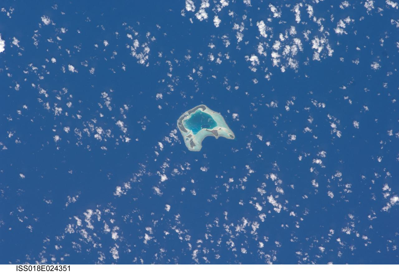
ISS018-E-024351 (27 Jan. 2009) --- Tetiaroa Island in French Polynesia is featured in this image photographed by an Expedition 18 crewmember on the International Space Station. This island, part of the Society Islands archipelago in the southern Pacific Ocean, is also known as ?Marlon Brando?s Island?. The late film star purchased the island ? more correctly, an atoll comprised of thirteen small islets (or motus) from the French Polynesian government for a total of 70,000 over 1966-1967. While the motus were his property, the government retained the rights to the coral reefs and lagoons to preserve control of marine resources. Following Brando?s death in 2004, ownership of the approximately 8 kilometers?wide atoll passed into other private hands, and there are now plans to build a luxury resort amongst the islets. This view illustrates the typical circular appearance of a fully-developed atoll. The ring of islands ? covered in green vegetation and white to tan sandy beaches ? develops on coral reefs, which originally form around a volcanic island. As the volcanic island gradually disappears due to subsidence and erosion, the coral reefs continue to grow upwards. Over time, the central volcanic island is completely submerged, leaving a ring of coral reefs and islands that surround a lagoon. The shallow lagoon waters appear blue-green in this image, and contrast with darker ? and deeper ? Pacific Ocean waters surrounding the atoll. One of the motus in the southern portion of the atoll, Tahuna Rahi, is a protected bird sanctuary, and is the nesting site of red- and brown-footed boobies, frigatebirds, and terns (among other species). Access to the atoll is via boat, as the airstrip was closed in 2004 due to safety and security concerns.
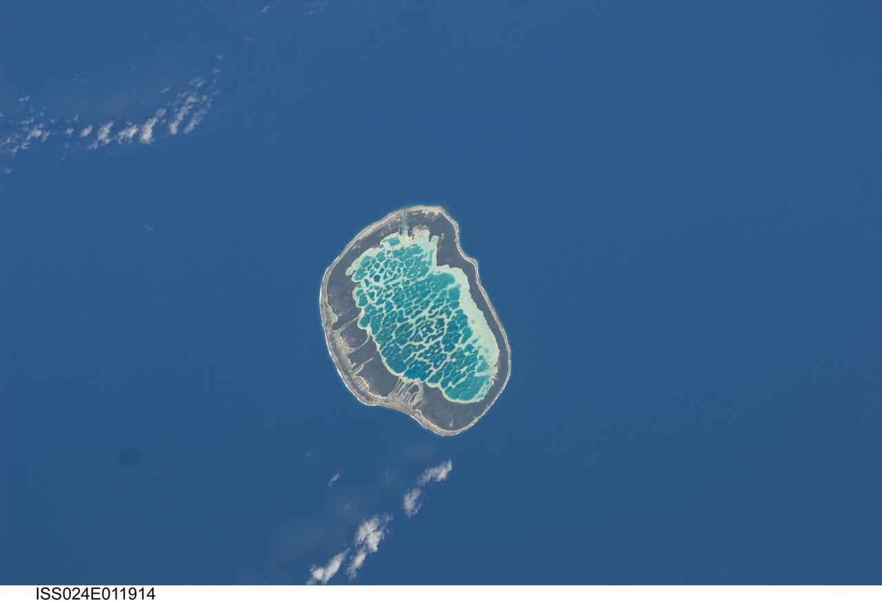
ISS024-E-011914 (13 Aug. 2010) --- Mataiva Atoll, Tuamotu Archipelago in the South Pacific Ocean is featured in this image photographed by an Expedition 24 crew member on the International Space Station. The Tuamotu Archipelago is part of French Polynesia, and forms the largest chain of atolls in the world. This photograph features Mataiva Atoll, the westernmost atoll of the Tuamotu chain. An atoll is a ring-shaped island that encloses a central lagoon. This distinctive morphology is usually associated with oceanic islands formed by volcanoes; coral reefs become established around the partially submerged volcanic cone. Over geologic time the central volcano becomes extinct, followed by erosion and subsidence beneath the sea surface, leaving the coral reefs as a ring around (or cap on) the submerged island remnant. Coral reefs exposed above the sea surface in turn experience erosion, sedimentation and soil formation, leading to the establishment of vegetation and complex ecosystems – including in many cases human habitation. Mataiva Atoll is notable in that its central lagoon includes a network of ridges (white, center) and small basins formed from eroded coral reefs. Mataiva means “nine eyes” in Tuamotuan, an allusion to nine narrow channels on the south-central portion of the island. The atoll is sparsely populated, with only a single village – Pahua – located on either side of the only pass providing constant connection between the shallow (light blue) water of the lagoon and the deeper (dark blue) adjacent Pacific Ocean. Much of the 10 kilometer-long atoll is covered with forest (greenish brown); vanilla and copra (dried coconut) are major exports from the atoll, but tourism is becoming a greater economic factor.
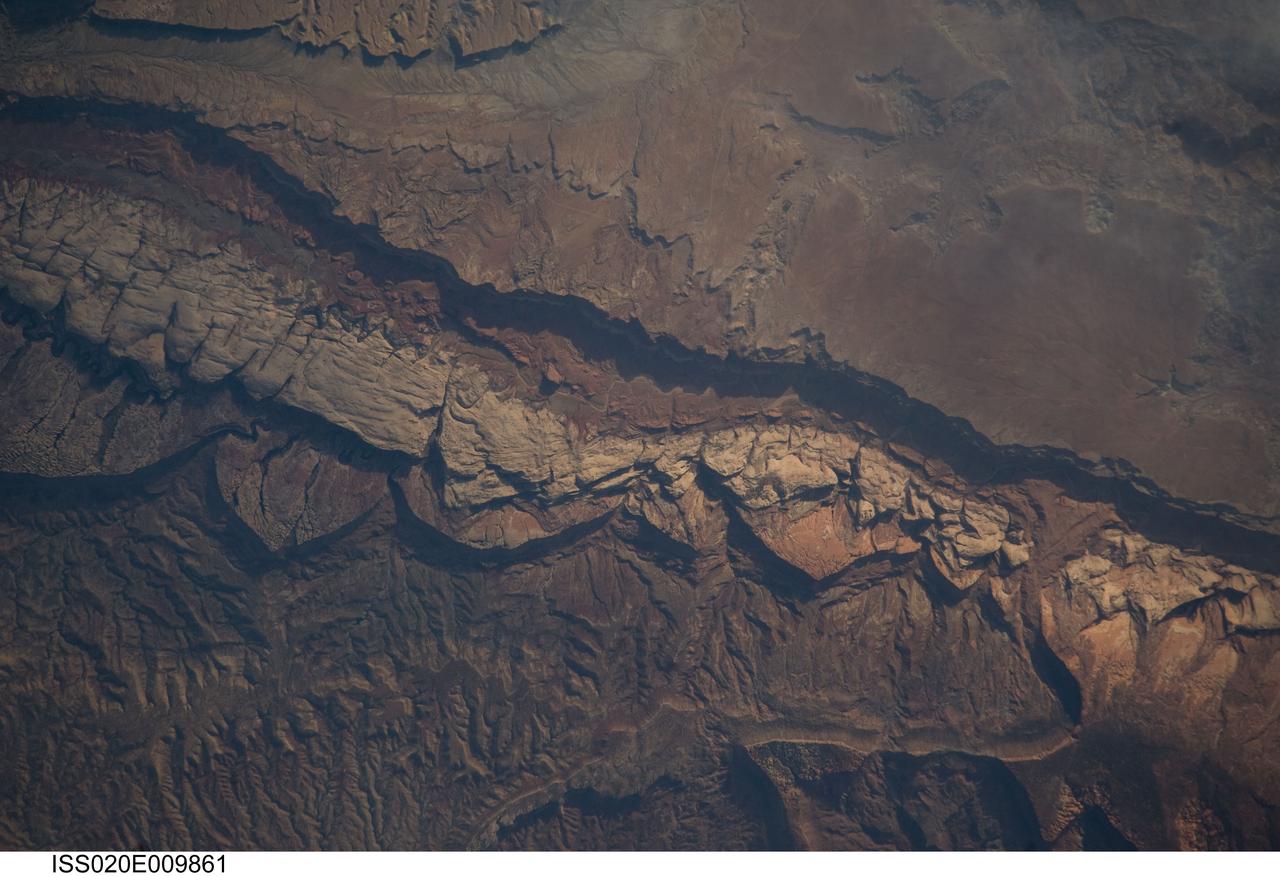
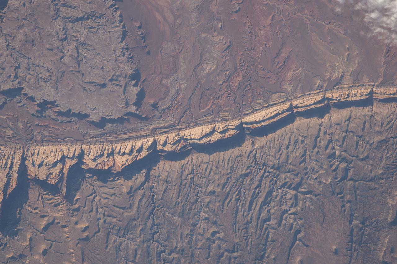
ISS020-E-009861 (14 June 2009) --- Big Thompson Mesa in the Capitol Reef National Park, Utah is featured in this image photographed by an Expedition 20 crew member on the International Space Station. This detailed photograph depicts a portion of Big Thompson Mesa located near the southern end of Capitol Reef National Park. Capitol Reef National Park is located on the Colorado Plateau, a physiographic and geologic province that comprises the adjacent quarters of Arizona, Colorado, New Mexico and Utah. Big Thompson Mesa (upper right) is part of a large feature known as the Waterpocket Fold. The Fold is a geologic structure called a monocline, characterized by generally flat-laying sedimentary rock layers with a steep and highly localized flexure– much like a carpet runner draped over a stair step. Monoclines on the Colorado Plateau are thought to be the result of faulting of stratigraphically lower and more brittle crystalline rocks; while the crystalline rocks were broken into raised or lowered blocks, the overlaying, less brittle sedimentary rocks were flexed without breaking. According to scientists, the portion of the Waterpocket Fold illustrated in this image includes layered rocks formed during the Mesozoic Era (approximately 250 – 65 million years ago) – the oldest layers are at the bottom of the sequence (and also, in this view, the image), with each successive layer younger than the preceding one going upwards in the sequence. Not all of the units present are clearly visible, but some of the major units can be easily distinguished. The bottom half of the image includes the oldest rocks in the view: dark brown and dark green Moenkopi (Trm) and Chinle (Trc) Formations. At center, two strikingly colored units are visible – light red to orange Wingate Sandstone (Jw) and white Navajo Sandstone (Jn). A topographic bench above these units includes reddish brown to brown Carmel Formation (Jc) and Entrada Sandstone (Je). The top of the cliff face above this bench - Big Thompson Mesa - is comprised of brown Dakota Sandstone (Kd). Scientists believe this sequence represents more than 100 million years of deposition. Much younger Quaternary (2.0 million to approximately 10,000 years old) deposits are also present in the view. A regional view of Capitol Reef National Park and the Waterpocket Fold is available here. The area shown in this view is located approximately 65 kilometers to the southeast of Fruita, UT near the southern end of Capitol Reef National Park.
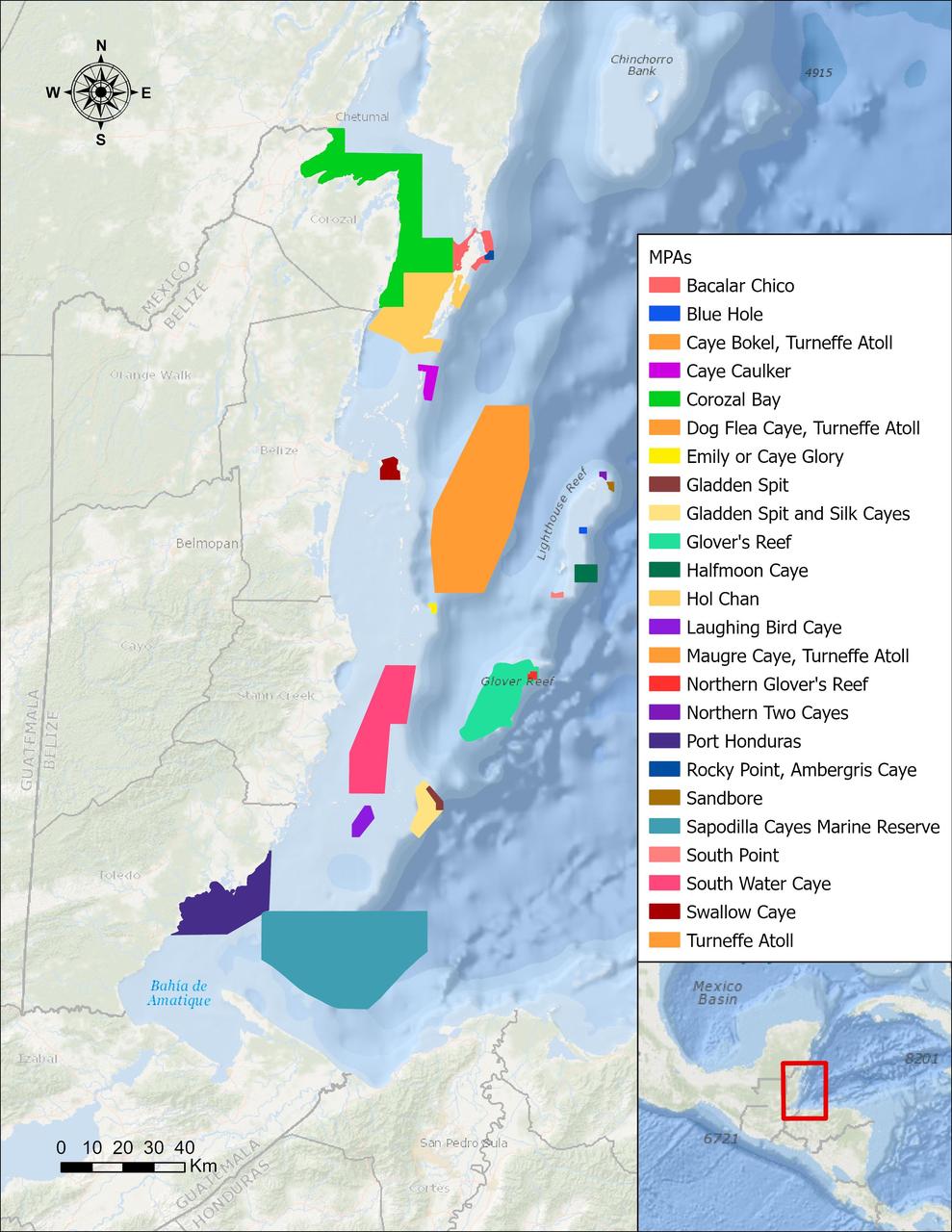
In a paper published in November 2022 in Frontiers in Remote Sensing, researchers at NASA's Jet Propulsion Laboratory, with colleagues in Belize, used data from the Moderate Resolution Imaging Spectroradiometer (MODIS) instrument aboard NASA's Aqua satellite to rank 24 protected marine areas off the Belizean coast based on the risks coral face from murky water and rising temperatures. All the areas are part of the 185-mile-long (298-kilometer-long) Belize Barrier Reef Reserve System, which encompasses a vibrant network of marine environments that supports thousands of animal and plant species and drives the Central American country's largest industry, tourism. The system is one of about 1,200 UNESCO World Heritage sites around the world. Analyzing imagery from 2002 to 2022, researchers developed a coral vulnerability index – a score between 2 and 12 that characterizes the risk to coral, with higher scores signifying greater risk. Their findings could help management authorities protect the reefs from human impacts such as development, overfishing, pollution, and climate change. Port Honduras Marine Reserve, a 156-square-mile (40,000-hectare) protected area in southern Belize, showed the highest coral vulnerability score: 10 out of 12. Based on the index, the study flags Port Honduras, Swallow Caye Wildlife Sanctuary, Sapodilla Cayes Marine Reserve, and Corozal Bay Wildlife Sanctuary as areas for concern. https://photojournal.jpl.nasa.gov/catalog/PIA25862
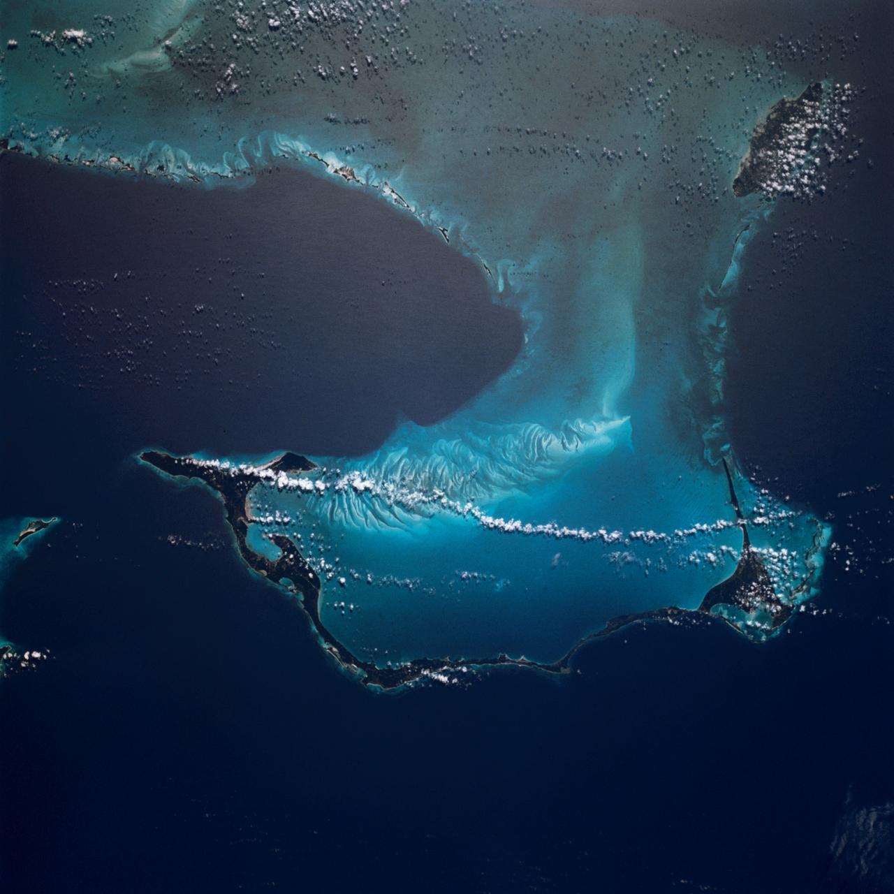
The light blue shallow water platforms of the Bahamas, (24.0N, 77.0W) which are separated by very deep dark blue channels make for a striking scene. In the foreground is Andros Island and in the background are the Tongue of the Ocean, the Exuma Islands, Exuma Sound and the Atlantic Ocean. The Bahamas are one of the few regions where calcium carbonate precipitates directly out of the water, as the mineral aragonite, to form the coral reef islands.
ISS042eE01551 (01/06/2015) --- NASA astronaut Terry Virts tweeted this night image out with the twinkling city lights of the coast of India and the Maldives. The Maldives is a tropical nation in the Indian Ocean composed of 26 coral atolls, which stretch for hundreds of islands. It’s known for its beaches, blue lagoons and extensive reefs. Terry tweeted this comment along with the image: " Moonlit clouds over southeast #India coastline, with Chennai, Bangalore, and Hyderabad."
STS111-368-036 (5-19 June 2002) --- This photo, giving detail of the Pompey Island Group in the Southern Great Barrier Reef off Australia, was taken by the STS-111 crewmembers aboard the Space Shuttle Endeavour. Ocean flow between the islands has produced unique wash features in the structures of the island banks. The Gateway to Astronaut Photography of Earth (link to http://eol.jsc.nasa.gov/sseop/) provides searchable access to other photographs of Earth taken by astronauts.
AS07-07-1774 (15 Oct. 1968) --- Red Sea coastal area of Saudi Arabia as seen from the Apollo 7 spacecraft during its 58th revolution of Earth. This picture shows extent of coral reefs in the Red Sea. Photographed from an altitude of 88 nautical miles, at ground elapsed time of 91 hours and 17 minutes.
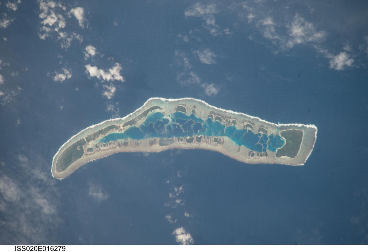
ISS020-E-016279 (1 July 2009) --- Millennium Island is featured in this image photographed by an Expedition 20 crew member on the International Space Station. Millennium Island ? known as Caroline Island prior to 2000 ? is located at the southern end of the Line Islands in the South Pacific Ocean. This uninhabited island is part of the Republic of Kiribati, an island nation comprised of 32 atolls (including Millennium Island) and one raised coral island. Millennium Island is formed from a number of smaller islets built on coral reefs. The coral reefs grew around a now-submerged volcanic peak, leaving a ring of coral around an inner lagoon. The islands above the waterline are composed primarily of limestone rock and sand derived from the reefs. At a maximum height of approximately 6 m above sea level, Millennium Island has been identified as being at great risk from sea level rise by the United Nations. The islets of Millennium Island are readily visible in this photograph as irregular green vegetated areas surrounding the inner lagoon. The shallow lagoon waters are a lighter blue than the deeper surrounding ocean water; tan linear ?fingers? within the lagoon are the tops of corals. The two largest islets are Nake Islet and South Islet, located at the north and south ends of Millennium Island respectively. The ecosystem of Millennium Island is considered to be relatively pristine despite periods of human habitation, guano mining, and agricultural activities, and the island has been recommended as both a World Heritage site and Biosphere Reserve.
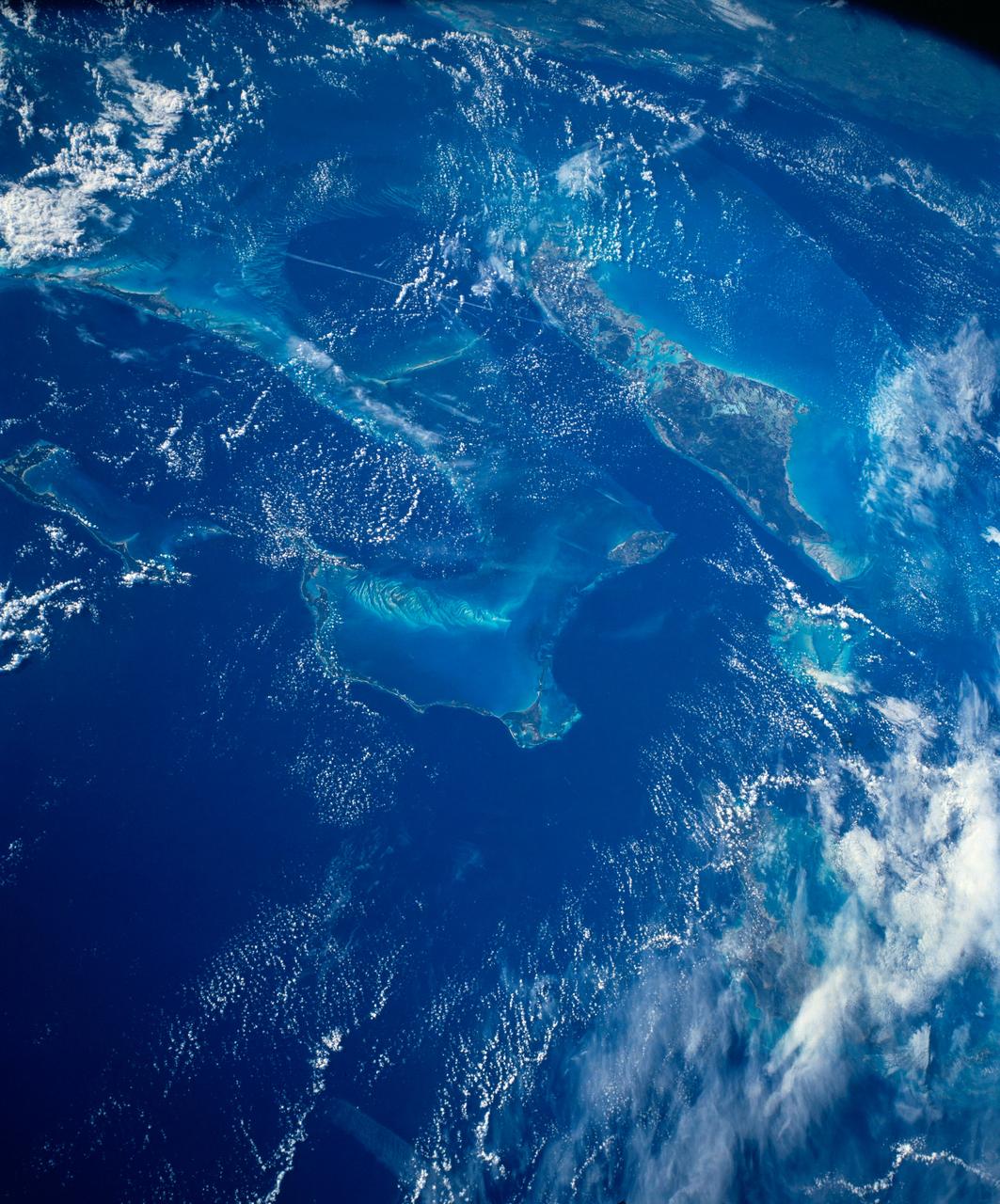
STS054-152-102 (13-19 Jan. 1993) --- This is a south-looking, wide angle view of the northern Bahamas, featuring the islands (from mid-foreground toward background) of Eleuthera, New Providence, and Andros. The northern shore of Cuba can be seen in the background. The resort city of Nassau occupies much of eastern New Providence. The Bahamas host some very distinctive features -- the deep blue channels and the shallow, light blue platforms, feathery sand bars at the edges of the deep water sounds, and colorful lakes and tidal channels like seen on Andros Island.
STS006-45-097 (4-9 April 1983) --- This photograph was taken with a handheld 70mm camera aimed through the “ceiling” windows of the Earth-orbiting space shuttle Challenger during its five-day STS-6 mission. A beautiful photo shows the contrast between the islands, clouds, shallow water and deep water. Islands of the Bahamas seen are New Providence (upper left) and Eleuthera (right). Northeast Providence Channel is at the upper edge and Exuma Sound is at the lower left with the open Atlantic along the right edge. The wind, from the south, causes a long cloud to develop downwind from Eleuthera Point. Photo credit: NASA
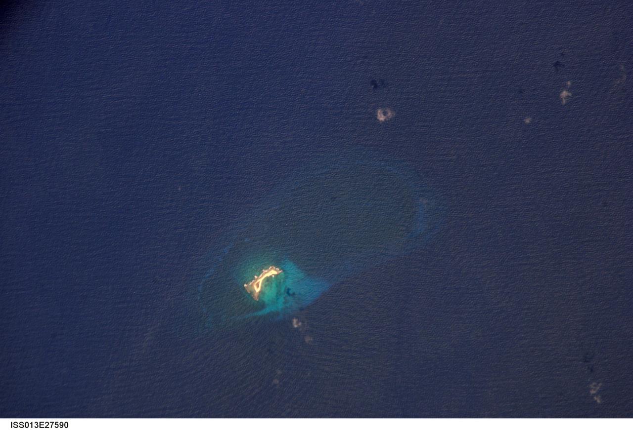
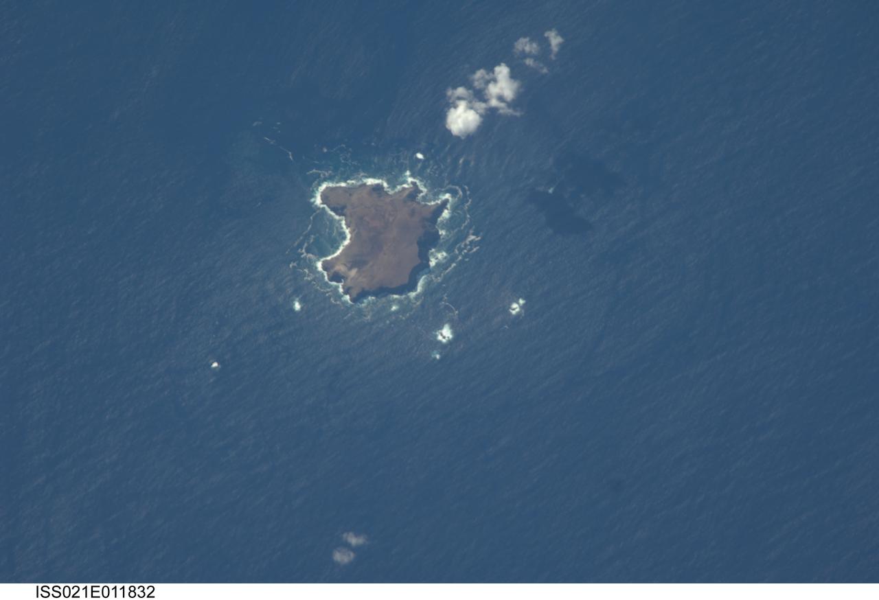
ISS013-E-27590 (27 May 2006) --- Aves Island, Caribbean Sea is featured in this image photographed by an Expedition 13 crewmember on the International Space Station. This image is a rare almost cloud free view of the island and the submerged fringing coral reef that surrounds it. Scientists believe the crosshatch-like pattern of roughness on the surrounding sea surface was caused by variable winds at the time of image acquisition. The island itself currently stands a mere 4 meters above the surrounding sea surface, and in high seas it can be completely submerged. While the low elevation of the island makes it a hazard to shipping, it also provides a major nesting site for green sea turtles (Chelonia mydas) in the Caribbean.
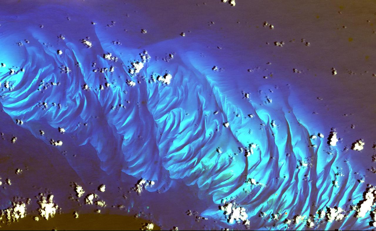
In this ASTER image the features that look like folded material are carbonate sand dunes in the shallow waters of Tarpum Bay, southwest of Eleuthera Island in the Bahamas. The sand making up the dunes comes from the erosion of limestone coral reefs, and has been shaped into dunes by ocean currents. This image was acquired on May 12, 2002 by the Advanced Spaceborne Thermal Emission and Reflection Radiometer (ASTER) on NASA's Terra satellite. With its 14 spectral bands from the visible to the thermal infrared wavelength region, and its high spatial resolution of 15 to 90 meters (about 50 to 300 feet), ASTER images Earth to map and monitor the changing surface of our planet. http://photojournal.jpl.nasa.gov/catalog/PIA03877
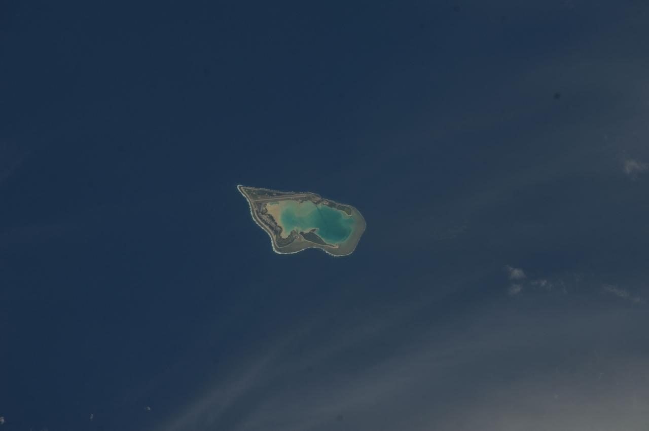
ISS033-E-007873 (27 Sept. 2012) --- Wake Island is featured in this image photographed by an Expedition 33 crew member on the International Space Station. The atoll of Wake Island is located in the central Pacific Ocean approximately 4,000 kilometers to the west-southwest of Hawaii and 2,400 kilometers to the northwest of Guam. In addition to Wake Island, the atoll includes the smaller Peale and Wilkes Island for a total land surface area of 6.5 square kilometers. Like many atolls in the Pacific, the islands and associated reefs formed around a submerged volcano. The lagoon in the center of the islands—characterized by shallow, light blue water in contrast to the surrounding darker, deeper Pacific Ocean waters—marks the approximate location of the summit crater of the volcano.
The Exmouth Gulf, western Australia, is bounded on the west by the Cape Ranges; near the base of the peninsula the Learmonth Airfield, site of a solar observatory, can be seen. Spit-accretion ridges formed on ancient beaches extend along the western edge of the peninsula, which today is lined by the Ningaloo Reef. Red mud carried by floodwaters, the result of Hurricane Bobby the previous week, cover flat coastal land along the eastern side of the gulf. The mud is mixing slowly with marine water as it filters through passes between mangrove-covered islands. A filamentous pattern in the gulf probably indicates a plankton bloom. Island paleodunes stretching from south to north cover the landscape.
The Red Sea golf resort in Sharm El Sheik, Egypt, where President Clinton met with Israeli Prime Minister Ehud Barak and Palestinian Authority President Yasser Arafat, stands out against the desert landscape in this image acquired on August 25, 2000. This image of the southern tip of the Sinai Peninsula shows an area about 30 by 40 kilometers (19 by 25 miles) in the visible and near infrared wavelength region. Vegetation appears in red. The blue areas in the water at the top and bottom of the image are coral reefs. The airport is visible just to the north of the golf resort. http://photojournal.jpl.nasa.gov/catalog/PIA02667
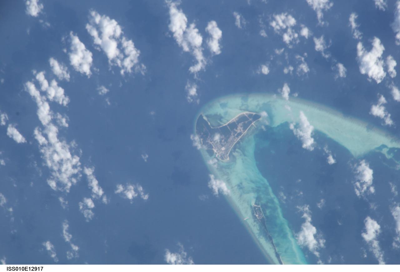
ISS010-E-12917 (13 January 2005) --- One of a series of post-tsunami digital still images photographed from the International Space Station on January 13, 2005. This image, centered at 4.9 degrees north latitude and 72.9 degrees east longitude, and one of several showing the Maldives, shows the east portion of Goidhoo (also called Horsburgh) Atoll. Also visible are Goidhoo (Goidu) Island and Fehendoo (Fehendu) Island. Information is sketchy on how much damage was actually sustained in the region, but NASA scientists studying the ISS imagery say that coral reefs likely mitigated the damage level.

ISS047e141619 (06/06/2016) --- This Earth observation image captured by Expedition 47 members aboard the International Space Station is of Juan de Nova Island, also known as Saint-Christophe. The small French tropical island is in the narrowest part of the Mozambique Channel, about one-third of the way between Madagascar and Mozambique. The Island is 3.7 miles long and 1 mile at its widest. It is a nature reserve surrounded by reefs. Forests cover about half the island and sea turtles nest on the beaches. It is largely uninhabited but the French maintain a weather station on the Island.

S129-E-007324 (21 Nov. 2009) --- One of the crew members onboard the space shuttle Atlantis recorded this still image of the Bahamas' lengthy narrow Eleuthra Island. Like most of the Bahama Islands, Eleuthra is composed mainly of limestone and coral, and rises from a vast submarine plateau. The island, 80 miles (133 kilometers) long, about two miles (three kilometers) wide and covering an area of 164 square miles (425 square kilometers), is generally low and flat, has many mangrove swamps, brackish lakes, coral reefs and shoals, and many miles of sandy beaches.
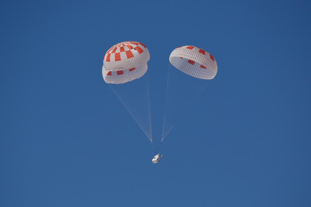
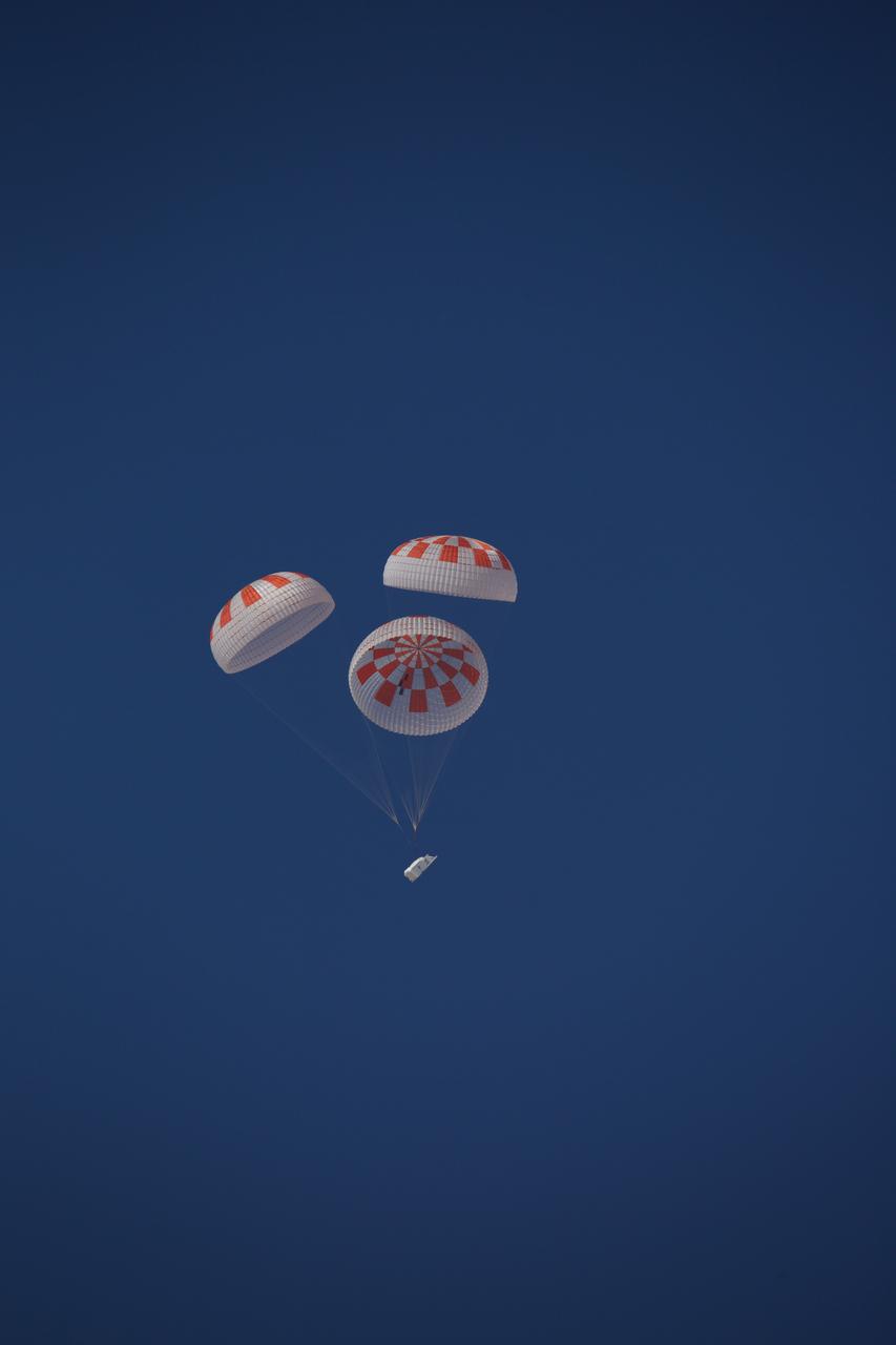
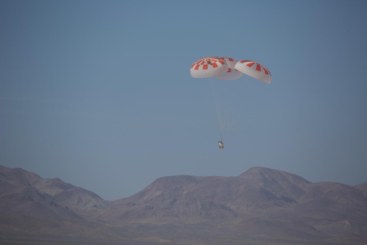
SpaceX performed its fourteenth overall parachute test supporting Crew Dragon development. This most recent exercise was the first of several planned parachute system qualification tests ahead of the spacecraft’s first crewed flight and resulted in the successful touchdown of Crew Dragon’s parachute system. During this test, a C-130 aircraft transported the parachute test vehicle, designed to achieve the maximum speeds that Crew Dragon could experience on re-entry, over the Mojave Desert in Southern California and dropped the vehicle from an altitude of 25,000 feet. The test demonstrated an off-nominal situation, deploying only one of the two drogue chutes and intentionally skipping a reefing stage on one of the four main parachutes, proving a safe landing in such a contingency scenario.
SpaceX performed its fourteenth overall parachute test supporting Crew Dragon development. This most recent exercise was the first of several planned parachute system qualification tests ahead of the spacecraft’s first crewed flight and resulted in the successful touchdown of Crew Dragon’s parachute system. During this test, a C-130 aircraft transported the parachute test vehicle, designed to achieve the maximum speeds that Crew Dragon could experience on re-entry, over the Mojave Desert in Southern California and dropped the vehicle from an altitude of 25,000 feet. The test demonstrated an off-nominal situation, deploying only one of the two drogue chutes and intentionally skipping a reefing stage on one of the four main parachutes, proving a safe landing in such a contingency scenario.
SpaceX performed its fourteenth overall parachute test supporting Crew Dragon development. This most recent exercise was the first of several planned parachute system qualification tests ahead of the spacecraft’s first crewed flight and resulted in the successful touchdown of Crew Dragon’s parachute system. During this test, a C-130 aircraft transported the parachute test vehicle, designed to achieve the maximum speeds that Crew Dragon could experience on re-entry, over the Mojave Desert in Southern California and dropped the vehicle from an altitude of 25,000 feet. The test demonstrated an off-nominal situation, deploying only one of the two drogue chutes and intentionally skipping a reefing stage on one of the four main parachutes, proving a safe landing in such a contingency scenario.
STS100-708-78 (19 April-1 May 2001) --- Southwest of the Bahamas and north of Hispaniola lie the Turks and Caicos Islands, photographed by the astronaut/cosmonaut crew aboard the Earth-orbiting Space Shuttle Endeavour. In this view, the extensive shallow water areas of Caicos Bank (turquoise blue) dominate to the south of the Caicos Islands. Caicos Bank covers an area of 7,680 square kilometers (1.9 million acres). The coral reefs of Caicos are primarily along the north deep water edge of the islands, and in a barrier along the south margin of the bank. The area is known for its marine caves and blowholes. To the east of Caicos Bank, near the tail of the Shuttle, is the island of Grand Turk, part of the much smaller Turks Bank. The channel that runs between the two banks is more than 2,200 meters (1.4 miles) deep.
61A-40-38 (30 Oct-6 Nov 1985) --- The coral reef forming the atoll of Midway sits atop a volcanic seamount that has descended more than 3,000 feet (1000 meters) below the sea surface in this ancient region of the Hawaiian volcanic chain. This view was taken by the crew members onboard the Earth-orbiting Space Shuttle Challenger. The crew consisted of astronauts Henry W. Hartsfield, Jr., commander; Steven R. Nagel, pilot; James F. Buchli, Guion S. Bluford, Jr., and Bonnie J. Dunbar, all mission specialists; Reinhard Furrer, Ernst Messerschmid, and Wubbo J. Ockels, all payload specialists. Ockels represents the European Space Agency (ESA).
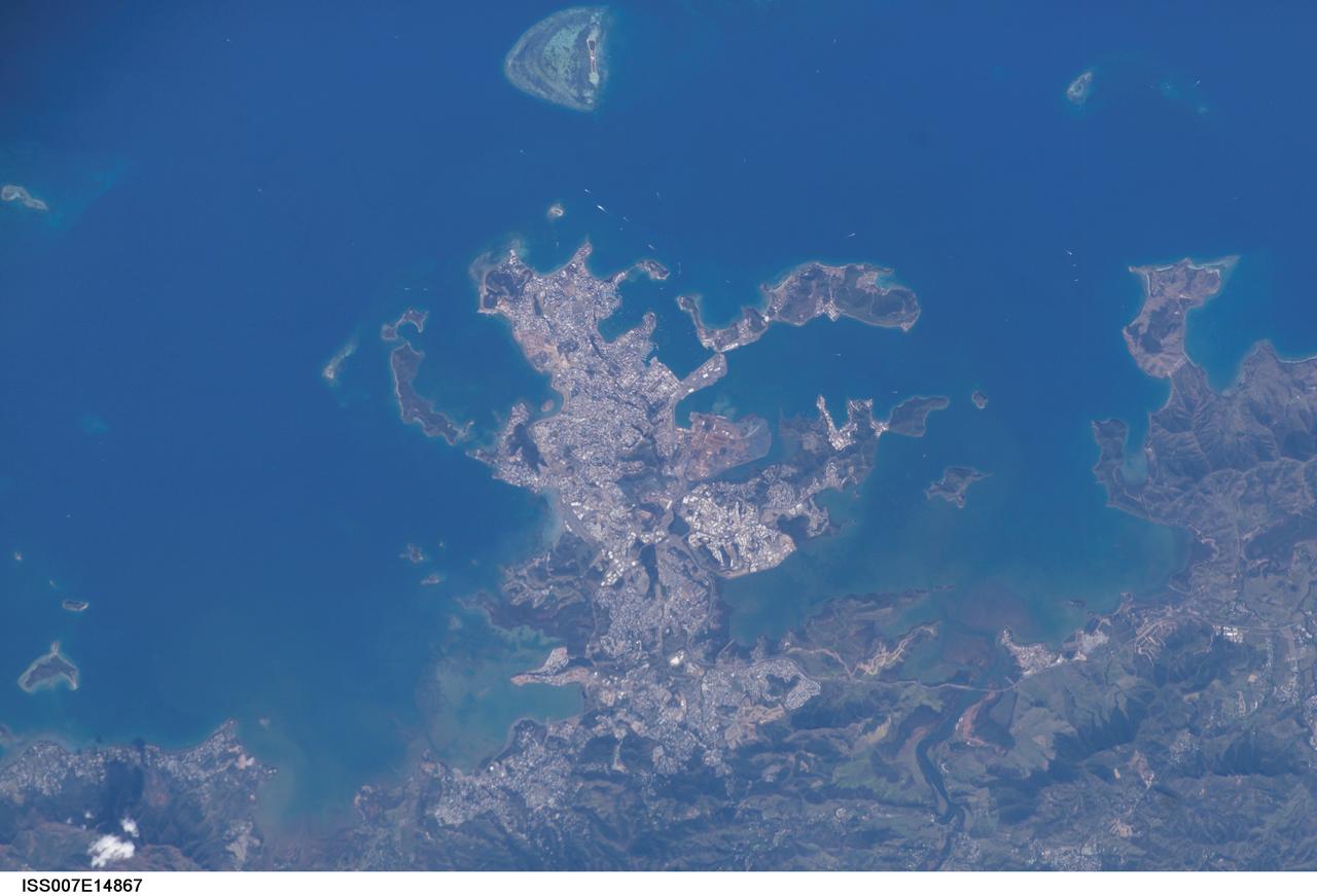
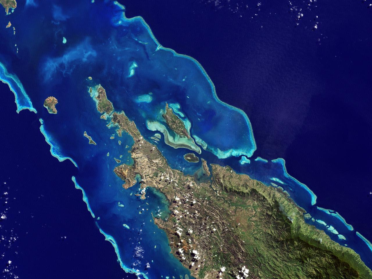
ISS007-E-14867 (13 September 2003) --- This view featuring Noumea, New Caledonia was taken by one of the Expedition 7 crewmembers onboard the International Space Station (ISS). The mountains forming the spine of the island of Grande Terre contain large reserves of nickel and chromium, and New Caledonia mines are one of the world’s greatest producers of nickel. This image shows details of New Caledonia’s main city, Noumea, which is built on a peninsula that juts into the lagoon on the southwest side of the island. The reefs here face localized problems from pollution and overfishing. The tourism industry is very important to the economy of Noumea, with extensive hotel development in the city and along the southeast coast of Grand Terre. The picture shows how urban development extends to the steep slopes of the coastal hills.
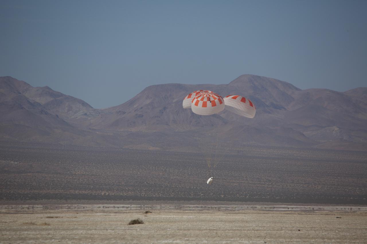
SpaceX performed its fourteenth overall parachute test supporting Crew Dragon development. This most recent exercise was the first of several planned parachute system qualification tests ahead of the spacecraft’s first crewed flight and resulted in the successful touchdown of Crew Dragon’s parachute system. During this test, a C-130 aircraft transported the parachute test vehicle, designed to achieve the maximum speeds that Crew Dragon could experience on re-entry, over the Mojave Desert in Southern California and dropped the vehicle from an altitude of 25,000 feet. The test demonstrated an off-nominal situation, deploying only one of the two drogue chutes and intentionally skipping a reefing stage on one of the four main parachutes, proving a safe landing in such a contingency scenario.
STS083-712-063 (4-8 April 1997) --- Northern half of Long Island, Bahamas. The vivid blues of the Bahamas stand out from space. Long Island and Great Exuma Island, which extends from the west north west into the photo, is on the eastern side of the Great Bahama Bank and form the borders of Exuma Sound. This photograph provides a rare opportunity to observe a natural chemical laboratory at work. Limestone of quite a different sort from that forming the Great Barrier Reef is actually in the process of formation. Long Island itself is little more than a sandbar rising just a few meters (about 30 to 50 meters) above sea level but it separates the deep, dark blue waters of the Atlantic on the right from the 10-meter (33 feet) shallows of the Great Bahama Bank (left). Details of the topography of the bank are visible through the clear waters. The shallow waters are warm and become extremely salty. Crystals of aragonite, a calcium carbonate mineral, are precipitated and formed into spherical sand-sized oolites as the tidal currents swirl back and forth. Lithification of the carbonate sands produces an oolithic limestone. Although the water is warm and clear, corals do not live in the shallows, probably because of the elevated salt content. Although chemically similar, the oolithic limestone forming Long Island is very different from coral reef limestone. An airfield is visible at the northern and central (bottom of photo) part of the island.

ISS017-E-008188 (29 May 2008) --- Dry Tortugas islands near Florida are featured in this image photographed by an Expedition 17 crewmember on the International Space Station. The Dry Tortugas are a group of islands located approximately 75 miles west of Key West, Florida; they form the western end of the Florida Keys in the Gulf of Mexico. Like the Keys, the Dry Tortugas are formed primarily of coral reefs over older limestone formations. The islands were named "Dry Tortugas" upon discovery by Ponce de Leon in 1513 -- "tortugas" means turtles in Spanish, and the islands are "dry" as no fresh water is found on them. From the air, the islands present an atoll-like arrangement, however no central volcanic structure is present. The islands are only accessible by boat or seaplane; nevertheless they have been designated the Dry Tortugas National Park, and are visited by hundreds every year. This view highlights three islands in the group; Bush Key, Hospital Key, and Garden Key -- the site of Fort Jefferson. Fort Jefferson is a Civil War era fort, perhaps most notable for being the prison of Dr. Samuel Mudd, who set the broken leg of John Wilkes Booth following Booth's assassination of President Lincoln. The fort itself is currently undergoing extensive restoration to prevent collapse of the hexagonal outer walls (center). The islands stand out due to brown and light tan carbonate sands visible above the Gulf of Mexico water surface. Light blue-green irregular masses in the image surrounding the islands are coral reef tops visible below the water surface.
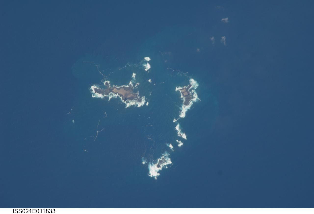
ISS021-E-011833 (22 Oct. 2009) --- The southern Savage Islands in the Atlantic Ocean are featured in this image photographed by an Expedition 21 crew member on the International Space Station. The Savage Islands, or Ilhas Selvagens in Portuguese, comprise a small archipelago in the eastern North Atlantic Ocean between the archipelago of Madeira to the north and the Canary Islands to the south. Like other island groups, the Savage Islands are thought to have been produced by volcanism related to a mantle plume or ?hot spot?. Mantle plumes are relatively fixed regions of upwelling magma that can feed volcanoes on an overlying tectonic plate. Active volcanoes form over the plume, and become dormant as they are carried away on the moving tectonic plate. Scientists believe that over geologic time, this creates a line of older extinct volcanoes, seamounts, and islands extending from the leading active volcanoes that are currently over the plume. This view illustrates the smaller and more irregularly-shaped Ilheus do Norte, Ilheu de Fora, and Selvagem Pequena. Spain and Portugal both claim sovereignty over the Savage Islands. All of the islands of the archipelago are ringed by bright white breaking waves along the fringing beaches. Coral reefs that surround the Savage Islands make it very difficult to land boats there, and there is no permanent settlement on the islands.
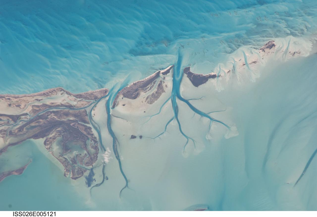
ISS026-E-005121 (27 Nov. 2010) --- Tidal flats and channels on Long Island, Bahamas are featured in this image photographed by an Expedition 26 crew member on the International Space Station. The islands of the Bahamas in the Caribbean Sea are situated on large depositional platforms (the Great and Little Bahama Banks) composed mainly of carbonate sediments ringed by fringing reefs – the islands themselves are only the parts of the platform currently exposed above sea level. The sediments are formed mostly from the skeletal remains of organisms settling to the sea floor; over geologic time, these sediments will consolidate to form carbonate sedimentary rocks such as limestone. This detailed photograph provides a view of tidal flats and tidal channels near Sandy Cay on the western side of Long Island, located along the eastern margin of the Great Bahama Bank. The continually exposed parts of the island have a brown coloration in the image, a result of soil formation and vegetation growth (left). To the north of Sandy Cay an off-white tidal flat composed of carbonate sediments is visible; light blue-green regions indicate shallow water on the tidal flat. Tidal flow of seawater is concentrated through gaps in the anchored land surface, leading to formation of relatively deep tidal channels that cut into the sediments of the tidal flat. The channels, and areas to the south of the island, have a vivid blue coloration that provides a clear indication of deeper water (center).
Caribbean Luxury - April 24th, 2003 Description: The Caicos Islands (pronounced KAY-kohss) in the northern Caribbean are a popular tourist attraction, renowned for their beautiful beaches, clear waters, scuba diving, and luxury resorts. The islands lie primarily along the northern perimeter of the submerged Caicos Bank (turquoise), a shallow limestone platform formed of sand, algae, and coral reefs covering 6,140 square kilometers (2,370 square miles). Credit: USGS/NASA/Landsat 7 To learn more about the Landsat satellite go to: <a href="http://landsat.gsfc.nasa.gov/" rel="nofollow">landsat.gsfc.nasa.gov/</a> <b><a href="http://www.nasa.gov/centers/goddard/home/index.html" rel="nofollow">NASA Goddard Space Flight Center</a></b> enables NASA’s mission through four scientific endeavors: Earth Science, Heliophysics, Solar System Exploration, and Astrophysics. Goddard plays a leading role in NASA’s accomplishments by contributing compelling scientific knowledge to advance the Agency’s mission. <b>Follow us on <a href="http://twitter.com/NASA_GoddardPix" rel="nofollow">Twitter</a></b> <b>Join us on <a href="http://www.facebook.com/pages/Greenbelt-MD/NASA-Goddard/395013845897?ref=tsd" rel="nofollow">Facebook</a></b>
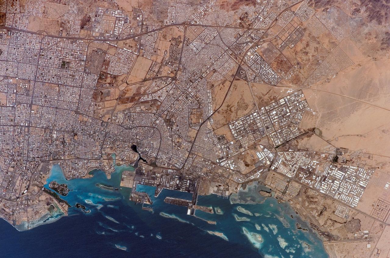
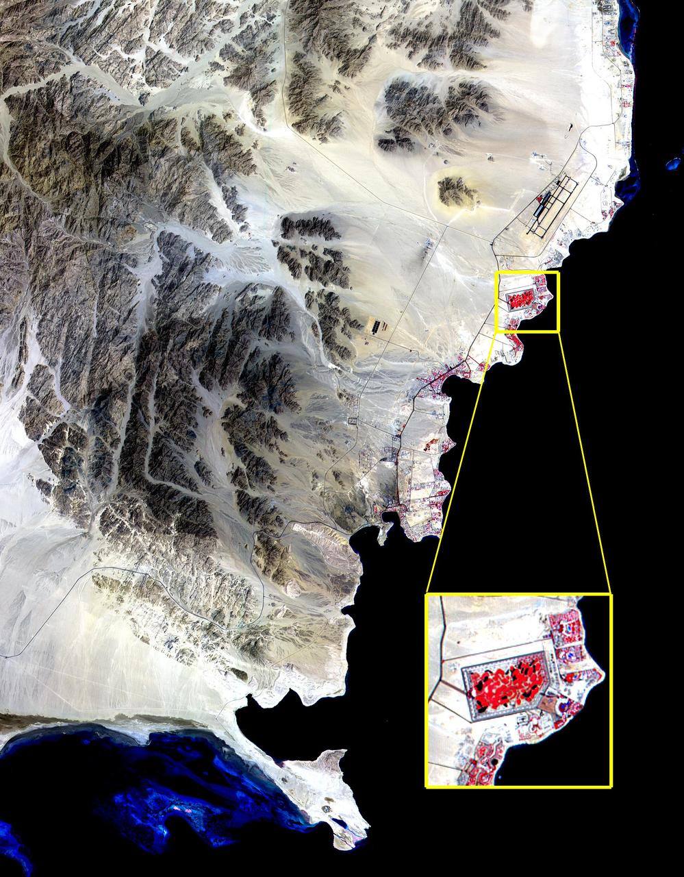
ISS010-E-20261 (19 March 2005) --- Jeddah, Saudi Arabia is featured in this image photographed by an Expedition 10 crewmember on the International Space Station. The city of Jeddah is the second largest city in Saudi Arabia (after Riyadh), and is the country’s most important Red Sea port. A large warehouse and dock complex is visible in the lower left portion of this image. Apart from being a major port for exchange of goods with Africa and Europe, Jeddah is of great importance for Islamic pilgrims going east to Mecca (a religious journey known as the hajj). In addition to urban attractions, coral reefs along the coast (north-south trending islands to image left) are frequented by divers visiting the city. The image captures the multicolored rooftops of homes and other buildings in the city, the oldest of which were built using coral from the nearby Red Sea and clay from the al-Manqabah lagoon in the center of the Al Balad district (center of image; lagoon is approximately 0.25 km across).
ISS021-E-011832 (22 Oct. 2009) --- The northern Savage Islands in the Atlantic Ocean are featured in this image photographed by an Expedition 21 crew member on the International Space Station. The Savage Islands, or Ilhas Selvagens in Portuguese, comprise a small archipelago in the eastern North Atlantic Ocean between the archipelago of Madeira to the north and the Canary Islands to the south. Like other island groups, the Savage Islands are thought to have been produced by volcanism related to a mantle plume or “hot spot”. Mantle plumes are relatively fixed regions of upwelling magma that can feed volcanoes on an overlying tectonic plate. Active volcanoes form over the plume, and become dormant as they are carried away on the moving tectonic plate. Scientists believe that over geologic time, this creates a line of older extinct volcanoes, seamounts, and islands extending from the leading active volcanoes that are currently over the plume. This view illustrates Selvagem Grande, the largest of the islands with an approximate area of four square kilometers. All of the islands of the archipelago are ringed by bright white breaking waves along the fringing beaches. Coral reefs that surround the Savage Islands make it very difficult to land boats there, and there is no permanent settlement on the islands.
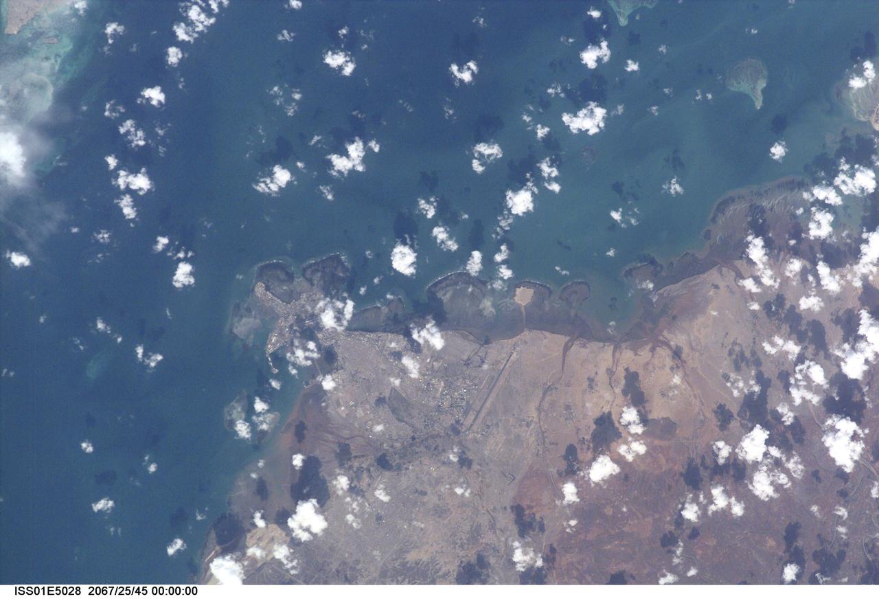
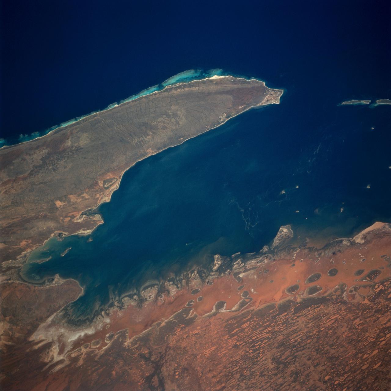
ISS001-E-5028 (December 2000) --- Djibouti, the capital city of the country of Djibouti, can be seen in this northeast-looking view taken from the International Space Station (ISS) with a digital still camera using a 400mm lens. Djibouti, scarcely 100 years old, sits on the western shore of an isthmus in the Gulf of Tadjoura, an arm of the Gulf of Aden. Djibouti is surrounded by a rugged and bleak landscape, that has a dry and hot climate. The population of Djibouti has grown from an estimated 96,000 in 1973 to over 330,000 in 1991 mainly due to the influx of refugees from the neighboring, war torn countries of Ethiopia and Somalia. With its strategically located port, Djibouti’s economic importance results from the large transit trade it enjoys as the terminus of a railroad line from Addis Ababa in Ethiopia. The city has seen an increase in tourism in the past decade due a large number of cruise ships visiting the port. Besides tourism, salt production and shipbuilding and repair are other major industries. Below the center of the image, the long runway of the Djibouti/Ambouli International Airport is visible. Coral reefs are discernible in the upper left and upper right quadrants of the image.
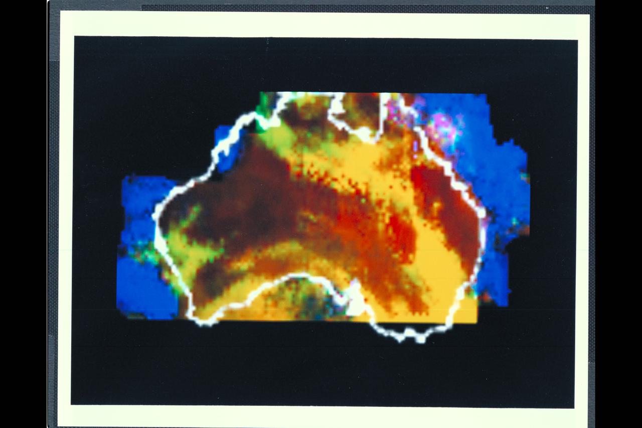
Range : 50,000 miles This multispectral map of Australia, and surrounding seas was obtained by the Galileo spacecraft's Near Infrared Mapping Spectrometer shortly after closest approach. The image shows various ocean, land and atmospheric cloud features as they appear in three of the 408 infrared colors or wavelengths sensed by the instrument. The wavelength of 0.873 micron, represented as blue in the photo, shows regions of enhanced liquid water absorption, i.e. the Pacific and Indian oceans. The 0.984-micron band, represented as red, shows areas of enhanced ground reflection as on the Australian continent. This wavelength is also s ensitive to the reflectivity of relatively thick clouds. The 0.939-micron wavelength, shown as green, is a strong water-vapor-absorbing band, and is used to accentuate clouds lying above the strongly absorbing lower atmosphere. When mixed with the red indicator of cloud reflection, the green produces a yellowish hue; this indicates thick clouds. The distinctive purplish color off the northeast coast marks the unusually shallow waters of the Great Barrier Reef and the Coral Sea. Here the blue denoting water absorption combines with the red denoting reflection from coral and surface marine organisms to produce thiss unusual color. The Near Infrared Mapping Spectrometer (NIMS) on the Galileo spacecraft is a combines mapping (imaging) and spectral instrument. It can sense 408 contiguous wavelengths from 0.7 micron (deep red) to 5.2 microns, and can construct a map or image by mechanical scanning. It can spectroscopically analyze atmospheres and surfaces and construct thermal and chemical maps.
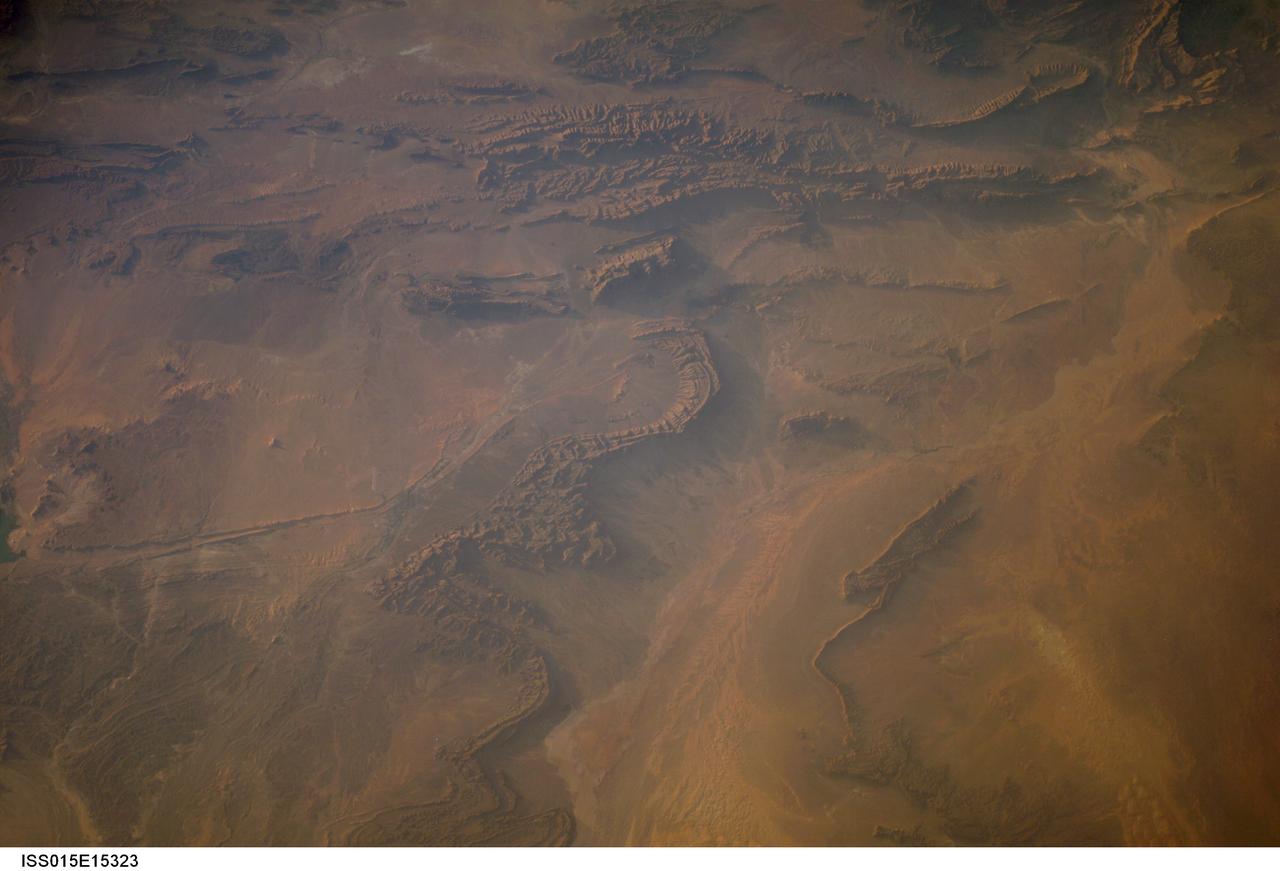
ISS015-E-15323 (27 June 2007) --- Part of Bechar Basin, Algeria is featured in this image photographed by an Expedition 15 crewmember on the International Space Station. The Bechar Basin of northwestern Algeria reaches depths of 8,000 meters, and is a producing hydrocarbon region. According to scientists, the basin was formed as Paleozoic (approximately 250-540 million years old) sedimentary layers were folded and faulted during much later collision of the continents of Africa and Europe during the Tertiary Period (approximately 2-65 million years ago). Hydrocarbon reservoirs are located within clastic (formed of variably-sized pieces of pre-existing rock) sedimentary rocks and fossilized coral reefs. Dark brown to tan folded ridges of these Paleozoic sedimentary layers extend across this view from top to bottom. Sand dunes are visible to the north, south, and west of the city of Bechar (gray-blue region to the left of the fold ridges) at center. Wadis (river channels) are dry most of the year in the arid climate of the region. Unconsolidated (loose) sands left in the channels by intermittent streams are transported by surface winds after the water is gone. This leads to the formation of individual dunes and larger dune fields (both bright tan in color) along the wadi courses, which also concentrate sands from other sources; dune fields are visible to the south of Bechar and at lower right. The oblique -- looking at an angle from the International Space Station, versus looking straight down - view of this photo accentuates cliff and dune shadows, providing a sense of the topography of the region.
The Anti-Atlas Mountains of Morocco formed as a result of the collision of the African and Eurasian tectonic plates about 80 million years ago. This collision destroyed the Tethys Ocean; the limestone, sandstone, claystone, and gypsum layers that formed the ocean bed were folded and crumpled to create the Anti-Atlas Mountains. In this ASTER image of southwest Morocco, visible, near infrared, and short wavelength infrared bands are combined to dramatically highlight the different rock types, and illustrate the complex folding. The ability to map geology using ASTER data is enhanced by bands that are sensitive to differences in rock mineralogy. The image was acquired on November 5, 2007, covers an area of 51.9 by 60.8 km, and is located at 28.1 degrees north and 10.7 degrees west. With its 14 spectral bands from the visible to the thermal infrared wavelength region and its high spatial resolution of about 50 to 300 feet (15 to 90 meters), ASTER images Earth to map and monitor the changing surface of our planet. ASTER is one of five Earth-observing instruments launched Dec. 18, 1999, on Terra. The instrument was built by Japan's Ministry of Economy, Trade and Industry. A joint U.S./Japan science team is responsible for validation and calibration of the instrument and data products. The broad spectral coverage and high spectral resolution of ASTER provides scientists in numerous disciplines with critical information for surface mapping and monitoring of dynamic conditions and temporal change. Example applications are monitoring glacial advances and retreats; monitoring potentially active volcanoes; identifying crop stress; determining cloud morphology and physical properties; wetlands evaluation; thermal pollution monitoring; coral reef degradation; surface temperature mapping of soils and geology; and measuring surface heat balance. https://photojournal.jpl.nasa.gov/catalog/PIA23533
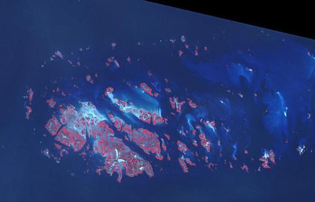
Chausey is a group of small islands and islets off the coast of Normandy and is part of the French Channel Islands. Chausey bounced back and forth between England and France for 800 years before finally officially belonging to France in the 19th century. The archipelago comprises 365 islands at low tide (2019 image), compared to only 52 islands at high tide (2018 image). The images were acquired July 7, 2018 and September 10, 2019, cover an area of 6.7 by 10.5 km, and are located at 48.9 degrees north, 1.8 degrees west. With its 14 spectral bands from the visible to the thermal infrared wavelength region and its high spatial resolution of about 50 to 300 feet (15 to 90 meters), ASTER images Earth to map and monitor the changing surface of our planet. ASTER is one of five Earth-observing instruments launched Dec. 18, 1999, on Terra. The instrument was built by Japan's Ministry of Economy, Trade and Industry. A joint U.S./Japan science team is responsible for validation and calibration of the instrument and data products. The broad spectral coverage and high spectral resolution of ASTER provides scientists in numerous disciplines with critical information for surface mapping and monitoring of dynamic conditions and temporal change. Example applications are monitoring glacial advances and retreats; monitoring potentially active volcanoes; identifying crop stress; determining cloud morphology and physical properties; wetlands evaluation; thermal pollution monitoring; coral reef degradation; surface temperature mapping of soils and geology; and measuring surface heat balance. https://photojournal.jpl.nasa.gov/catalog/PIA25800
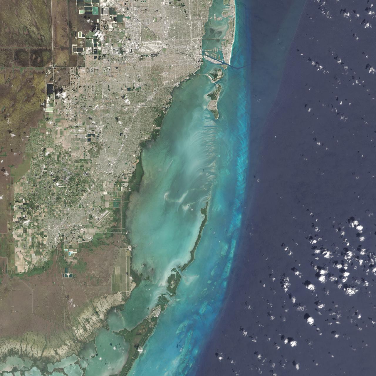
On February 25, 2016, the Operational Land Imager (OLI) on the Landsat 8 satellite acquired this natural-color image of Biscayne National Park. The park encompasses the northernmost Florida Keys, starting from Miami to just north of Key Largo. The keys run like a spine through the center of the park, with Biscayne Bay to the west and the Atlantic Ocean to the east. The water-covered areas span more than 660 square kilometers (250 square miles) of the park, making it the largest marine park in the U.S. National Park System. Biscayne protects the longest stretch of mangrove forest on the U.S. East Coast, and one of the most extensive stretches of coral reef in the world. Read more: <a href="http://go.nasa.gov/1SWs1a3" rel="nofollow">go.nasa.gov/1SWs1a3</a> Credit: NASA/Landsat8 <b><a href="http://www.nasa.gov/audience/formedia/features/MP_Photo_Guidelines.html" rel="nofollow">NASA image use policy.</a></b> <b><a href="http://www.nasa.gov/centers/goddard/home/index.html" rel="nofollow">NASA Goddard Space Flight Center</a></b> enables NASA’s mission through four scientific endeavors: Earth Science, Heliophysics, Solar System Exploration, and Astrophysics. Goddard plays a leading role in NASA’s accomplishments by contributing compelling scientific knowledge to advance the Agency’s mission. <b>Follow us on <a href="http://twitter.com/NASAGoddardPix" rel="nofollow">Twitter</a></b> <b>Like us on <a href="http://www.facebook.com/pages/Greenbelt-MD/NASA-Goddard/395013845897?ref=tsd" rel="nofollow">Facebook</a></b> <b>Find us on <a href="http://instagrid.me/nasagoddard/?vm=grid" rel="nofollow">Instagram</a></b>
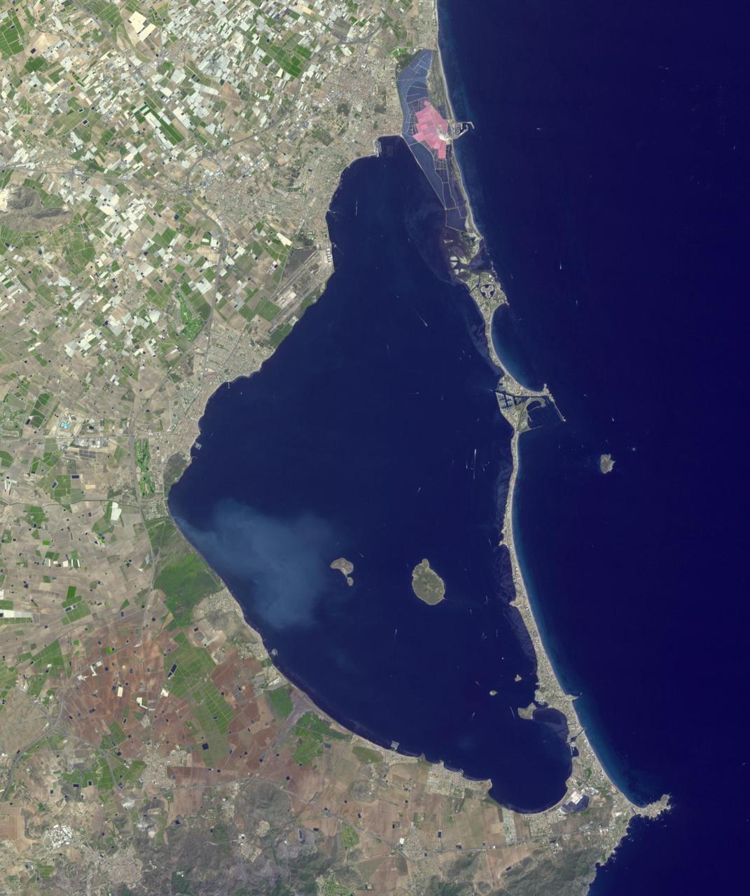
Mar Menor, in southeast Spain, is Europe's largest coastal saltwater lagoon. For the past 40 years, Mar Menor has faced severe contamination from agricultural runoff, leading to large algal blooms, and ecological degradation. Now, major restoration and prevention programs are in place to restore the lagoon, and try to reverse the damage. The image was acquired August 24, 2023, covers an area of 22.6 by 27.4 km, and is located at 37.7 degrees north, 0.8 degrees west. With its 14 spectral bands from the visible to the thermal infrared wavelength region and its high spatial resolution of about 50 to 300 feet (15 to 90 meters), ASTER images Earth to map and monitor the changing surface of our planet. ASTER is one of five Earth-observing instruments launched Dec. 18, 1999, on Terra. The instrument was built by Japan's Ministry of Economy, Trade and Industry. A joint U.S./Japan science team is responsible for validation and calibration of the instrument and data products. The broad spectral coverage and high spectral resolution of ASTER provides scientists in numerous disciplines with critical information for surface mapping and monitoring of dynamic conditions and temporal change. Example applications are monitoring glacial advances and retreats; monitoring potentially active volcanoes; identifying crop stress; determining cloud morphology and physical properties; wetlands evaluation; thermal pollution monitoring; coral reef degradation; surface temperature mapping of soils and geology; and measuring surface heat balance. https://photojournal.jpl.nasa.gov/catalog/PIA26009
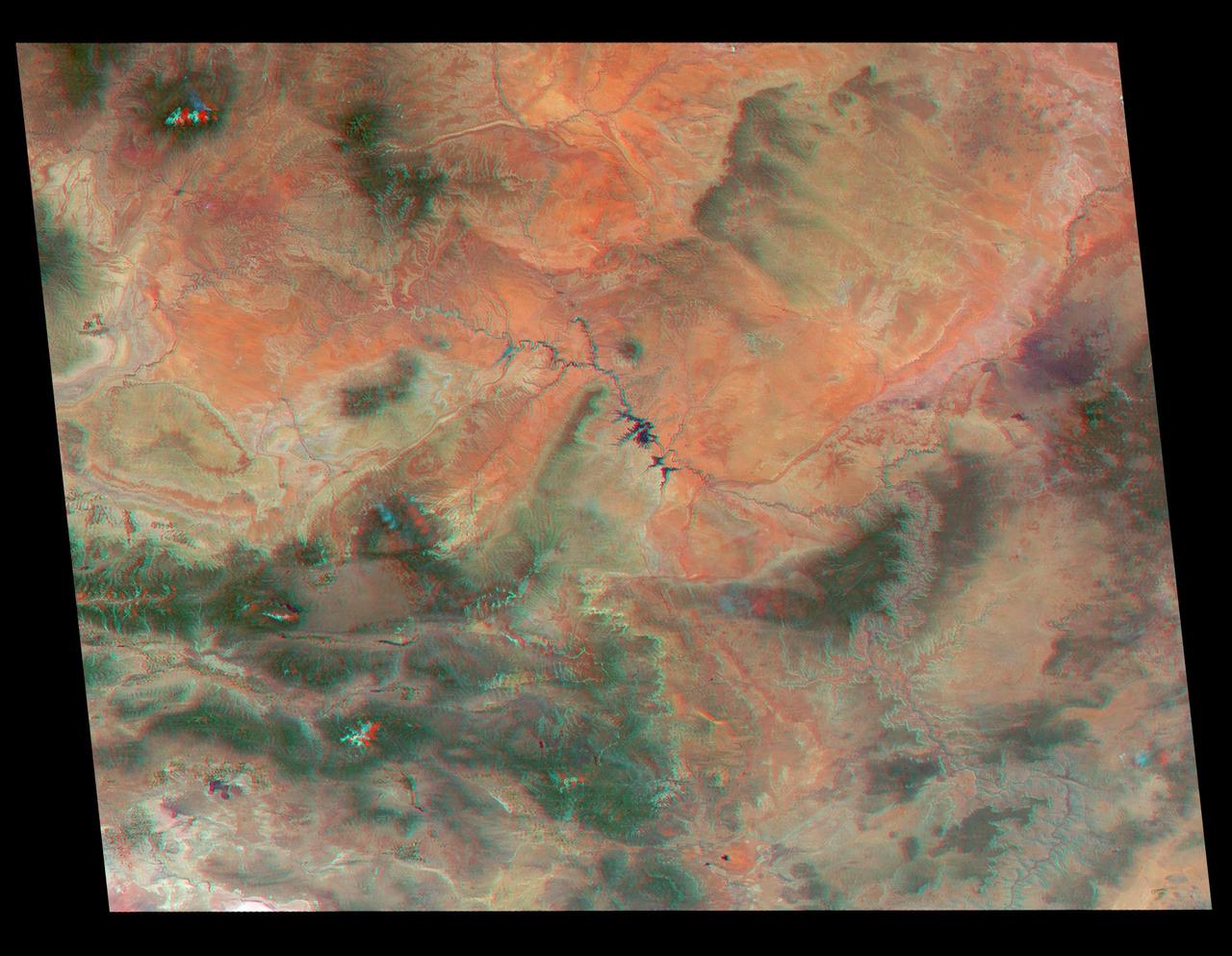
Just in time for the U.S. National Park Service's Centennial celebration on Aug. 25, NASA's Multiangle Imaging SpectroRadiometer (MISR) instrument aboard NASA's Terra satellite is releasing four new anaglyphs that showcase 33 of our nation's national parks, monuments, historical sites and recreation areas in glorious 3D. Shown in the annotated image are Walnut Canyon National Monument, Sunset Crater Volcano National Monument, Wupatki National Monument, Grand Canyon National Park, Pipe Spring National Monument, Zion National Park, Cedar Breaks National Monument, Bryce Canyon National Park, Capitol Reef National Park, Navajo National Monument, Glen Canyon National Recreation Area, Natural Bridges National Monument, Canyonlands National Park, and Arches National Park. MISR views Earth with nine cameras pointed at different angles, giving it the unique capability to produce anaglyphs, stereoscopic images that allow the viewer to experience the landscape in three dimensions. The anaglyphs were made by combining data from MISR's vertical-viewing and 46-degree forward-pointing camera. You will need red-blue glasses in order to experience the 3D effect; ensure you place the red lens over your left eye. The images have been rotated so that north is to the left in order to enable 3D viewing because the Terra satellite flies from north to south. All of the images are 235 miles (378 kilometers) from west to east. These data were acquired June 18, 2016, Orbit 87774. http://photojournal.jpl.nasa.gov/catalog/PIA20889
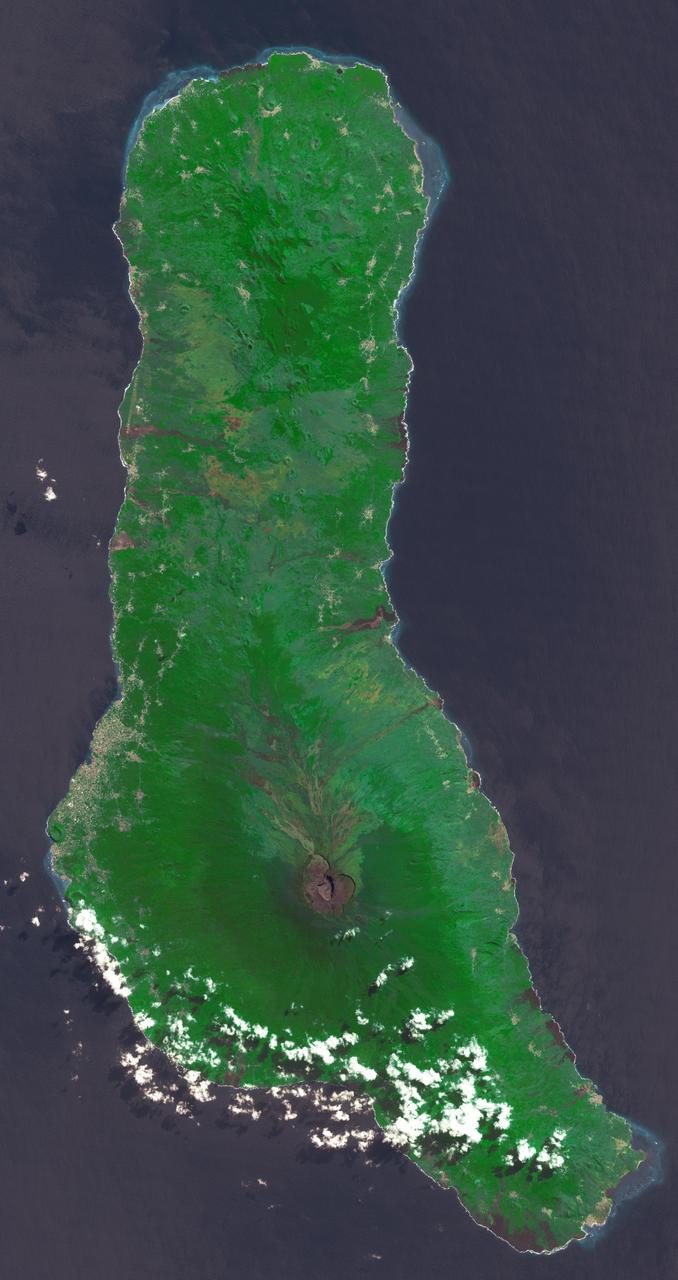
Grande Comore is the largest island of the Union of the Comoros, an island nation located in the Mozambique Channel northwest of Madagascar. The nation was granted independence from France in 1975, and became the Federated Islamic Republic of the Comoro Islands. In 2001, the government reformed as the Union of the Comoros. The three islands making up the country are all of volcanic origin, and Grande Comore is still volcanically active. The image was acquired June 22, 2022, covers an area of 25.7 by 67.4 km, and is located at 11.7 degrees south, 43.3 degrees east. With its 14 spectral bands from the visible to the thermal infrared wavelength region and its high spatial resolution of about 50 to 300 feet (15 to 90 meters), ASTER images Earth to map and monitor the changing surface of our planet. ASTER is one of five Earth-observing instruments launched Dec. 18, 1999, on Terra. The instrument was built by Japan's Ministry of Economy, Trade and Industry. A joint U.S./Japan science team is responsible for validation and calibration of the instrument and data products. The broad spectral coverage and high spectral resolution of ASTER provides scientists in numerous disciplines with critical information for surface mapping and monitoring of dynamic conditions and temporal change. Example applications are monitoring glacial advances and retreats; monitoring potentially active volcanoes; identifying crop stress; determining cloud morphology and physical properties; wetlands evaluation; thermal pollution monitoring; coral reef degradation; surface temperature mapping of soils and geology; and measuring surface heat balance. https://photojournal.jpl.nasa.gov/catalog/PIA25444

ISS012-E-06456 (3 Nov. 2005) --- Salar de Uyuni, the largest Salar (salt flat) in the world, located within the Altiplano of Bolivia, South America is featured in this image photographed by an Expedition 12 crewmember on the International Space Station. The Altiplano is a high plateau formed during uplift of the Andes Mountains. The plateau harbors fresh and saltwater lakes, together with Salars, that are surrounded by mountains with no drainage outlets--all at elevations greater than 3,659 meters (12,000 feet) above mean sea level. The Salar de Uyuni covers approximately 8,000 square kilometers (3,100 square miles), and it is a major transport route across the Bolivian Altiplano due to its flatness. This image features the northern end of the Salar and the dormant volcano Mount Tunupa (image center). This mountain is high enough to support a summit glacier, and enough rain falls on the windward slopes to provide water for small communities along the base. The dark volcanic rocks comprising Mt. Tunupa are in sharp contrast with the white, mineral-crusted surface of the Salar. The major minerals are halite--common table salt--and gypsum--a common component of drywall. Relict shorelines visible in the surface salt deposits (lower right of the image) attest to the occasional presence of small amounts of water in the Salar. Sediments in the Salar basin record fluctuations in water levels that occurred as the lake that once occupied the Salar evaporated. These sediments provide a valuable paleoclimate record for the region. The dynamic geological history of the Altiplano is recorded in isolated "islands" within the salt flat (image left); these islands are typically built from fossil coral reefs covered by Andean volcanic rocks.
ISS022-E-024557 (12 Jan. 2010) --- Male Atoll and Maldive Islands in the Indian Ocean are featured in this image photographed by an Expedition 22 crew member on the International Space Station. This detailed photograph features one of the numerous atolls in the Maldive Island chain. The Maldives are an island nation, comprised of twenty-six atolls that stretch in a north-to-south chain for almost 900 kilometers southwest of the Indian subcontinent. The silvery, almost pink sheen on the normally blue water of the equatorial Indian Ocean is the result of sunglint. Sunglint occurs when sunlight is reflected off of a water surface directly back towards the observer ? in this case a crew member on the space station. Full sunglint in images typically results in bright silver to white coloration of the water surface. Sunglint images can have different hues depending on the roughness of the water surface and atmospheric conditions. They also can reveal numerous details of water circulation which are otherwise invisible. This image was taken during the Indian Ocean Northeast monsoon season - predominant winds in this area create sinuous surface water patterns on the leeward side, and between, the islets (left). A south-flowing current flows in the deeper water through the Maldives most of the year (right), with fan-shaped surface currents formed by local tides pulsing in and out of the shallow water near the islands (top and bottom). The largest island seen here (center) is 6 kilometers long, and is one of the outer ring of larger islands that make up the 70 kilometers-long, oval-shaped Male Atoll. Shores facing deeper water have well-defined beaches. Numerous small, elliptical coral reef islets are protected within the ring of shallow water to the northeast (left). These islets are mostly awash at high tide, with dry ground appearing in tiny patches only. A small boat was navigating between the islets at the time the image was taken as indicated by its v-shaped wake at bottom left. Images like these illustrate why the Republic of Maldives is one of the most outspoken countries in stressing the dangers of rising sea levels.