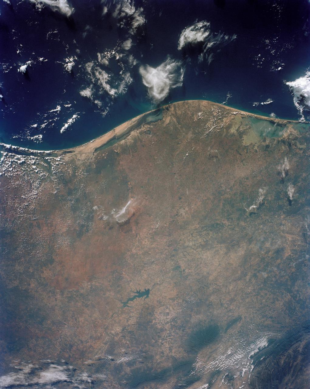
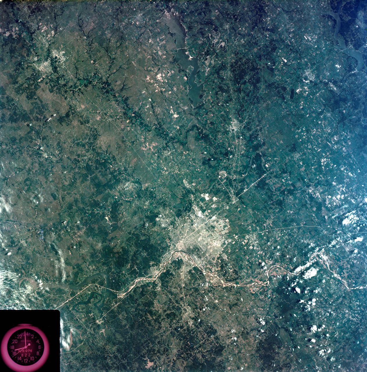
STS043-151-043 (8 August 1991) --- The Rio Grande extends across the center of this photograph from Falcon Reservoir to its bulging delta, joining the Gulf of Mexico. Sediment brought down by the river is spread northward and southward by alongshore currents to form the barrier chain of Padre Island and its protected Laguna Madre Speckled agricultural land use patterns in the river valley contrast with range land northward from the white cloud, and with closed canopy forest on hills in Mexico. A Linhof camera with a 90mm lens, was used to expose the frame at 14:43 GMT, Aug. 8, 1991.
Recorded by the Space Shuttle Atlantis STS-110 mission, this is a photograph of the ice- covered Manicouagin Reservoir located in the Canadian Shield of Quebec Province in Eastern Canada, partially obscured by low clouds. This reservoir marks the site of an impact crater, 60 miles (100 kilometers) wide, which according to geologists was formed 212 million years ago when a meteorite crashed into this area. Over millions of years, the crater has been worn down by glaciers and other erosional processes. The Space Shuttle Orbiter Atlantis, STS-110 mission, was launched April 8, 2002 and returned to Earth April 19, 2002.
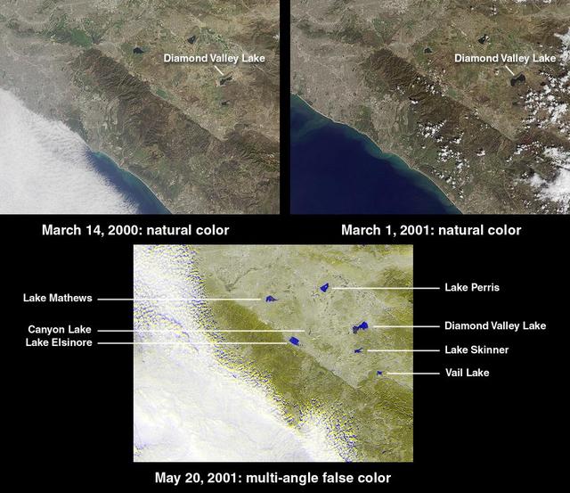
This image from NASA Terra satellite of Diamond Valley Lake Reservoir, near the city of Hemet in Riverside County, billed as the largest earthworks construction project in U.S.history.
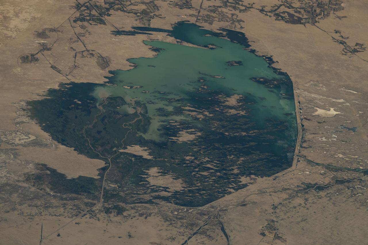
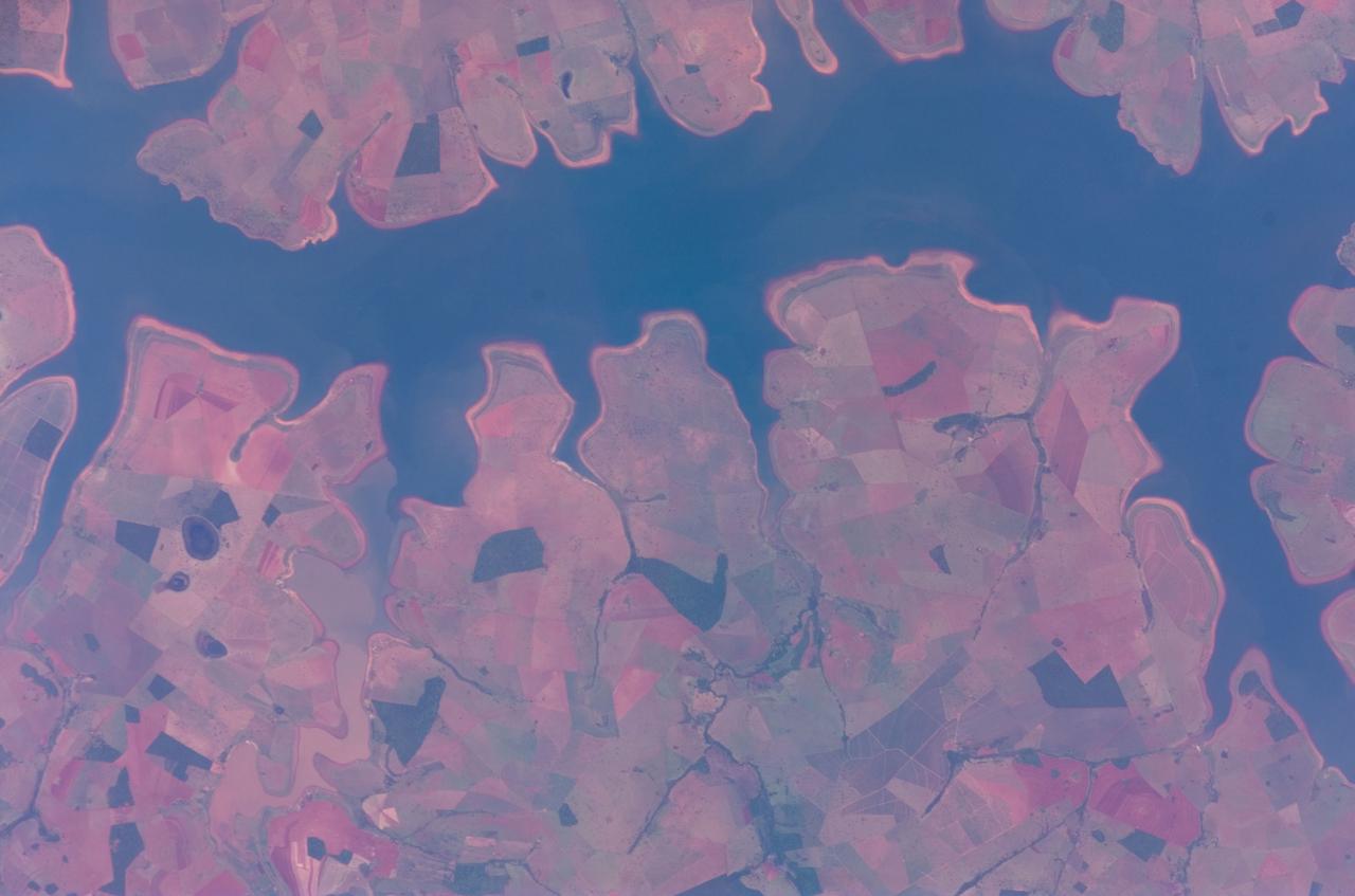
iss073e0423962 (Aug. 7, 2025) --- The Zeid Reservoir in Turkmenistan is pictured from the International Space Station as it orbited 260 miles above Central Asia. The reservoir was designed to capture some of the sand and sediment flowing in from the nearby Amu Darya River and the Karakum Canal. This helps keep the water cleaner and protects the canal system from getting clogged.

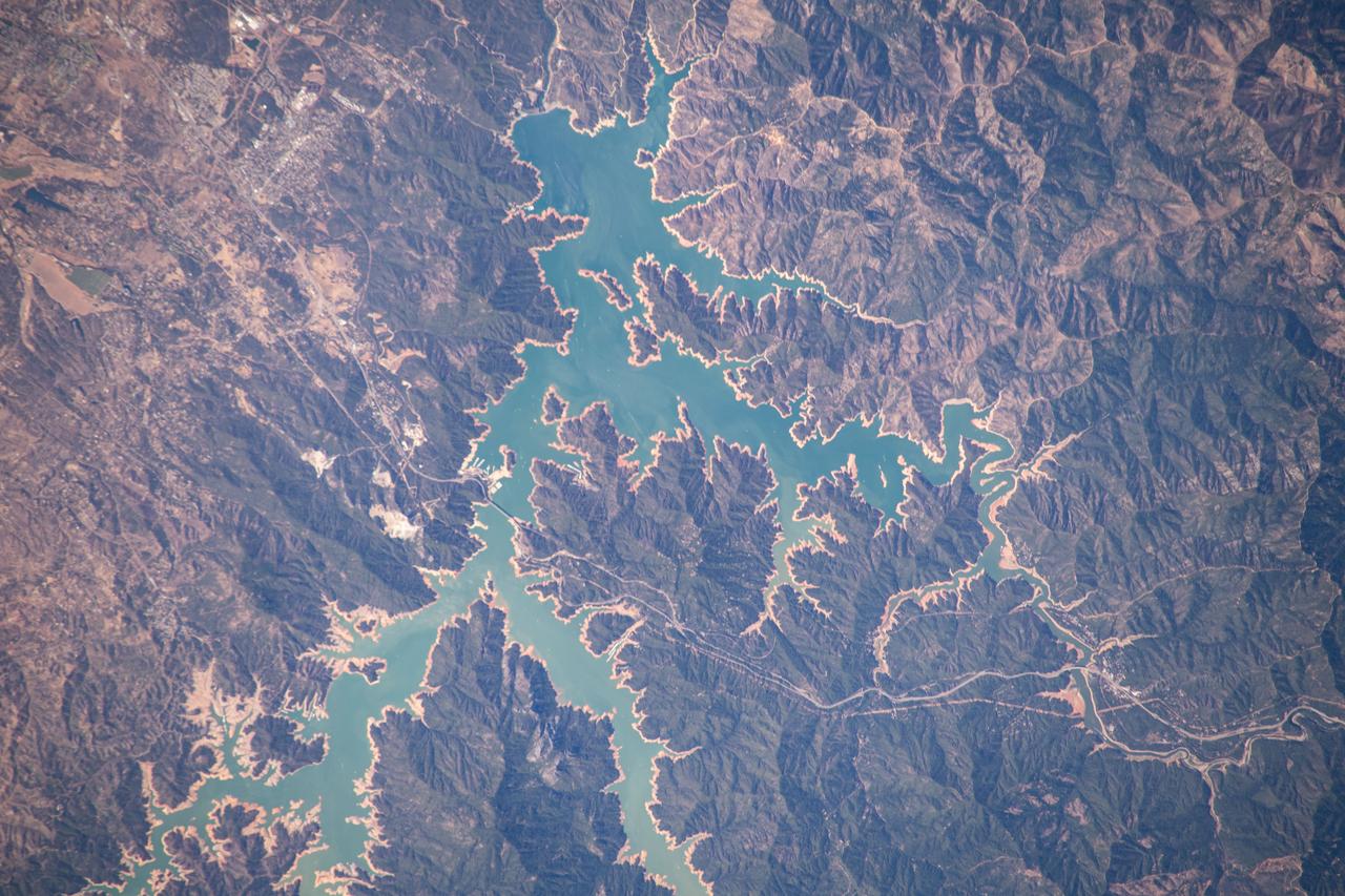
The Falcon International Reservoir is on the Rio Grande, 65 km southeast of Laredo, Texas, USA and Nuevo Laredo, Tamaulipas, Mexico. The Falcon Dam was constructed in 1953 to provide water conservation, irrigation, and hydroelectricity. Its maximum surface area, seen in the 2010 image, was 34,000 hectares. As a result of the 2010s-20s drought, the reservoir holds only a small fraction of its capacity. In 2010, vegetation in the area was healthy (dark red); in 2022, the area is parched. The images were acquired 14 July 2010 and 31 July 2022, cover an area of 29.8 by 46.9 km, and are located at 26.6 degrees north, 99.2 degrees west. https://photojournal.jpl.nasa.gov/catalog/PIA25446
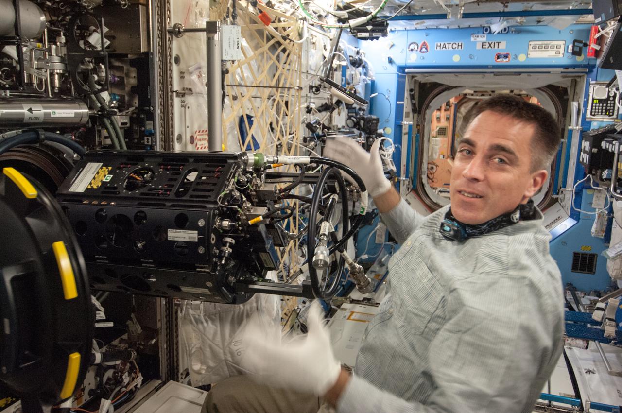
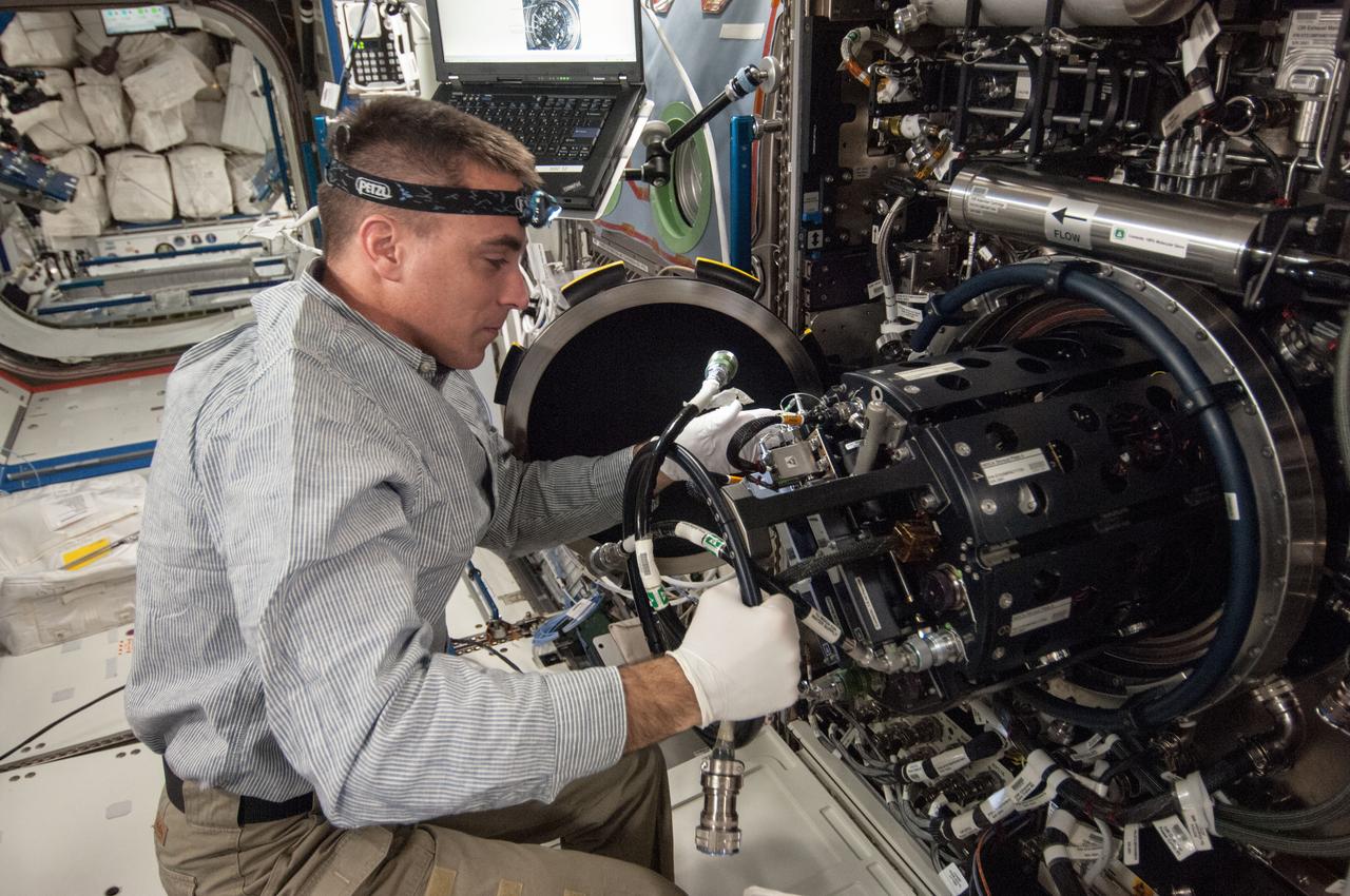
ISS035-E-017699 (10 April 2013) --- This is one of several photos documenting the Multi-user Droplet Combustion Apparatus (MDCA) Fuel Reservoir replacement. Here, Expedition 35 Flight Engineer Chris Cassidy removes and replaces one of the Fuel Reservoirs with the MDCA Chamber Insert Assembly (CIA) pulled partially out of the Combustion Chamber. The MDCA Fuel Reservoirs contain the liquid fuel used during droplet combustion experiments. This reservoir change-out was in support of the FLame EXtinguishment (FLEX)-2 experiment, scheduled to be executed by ground controllers.
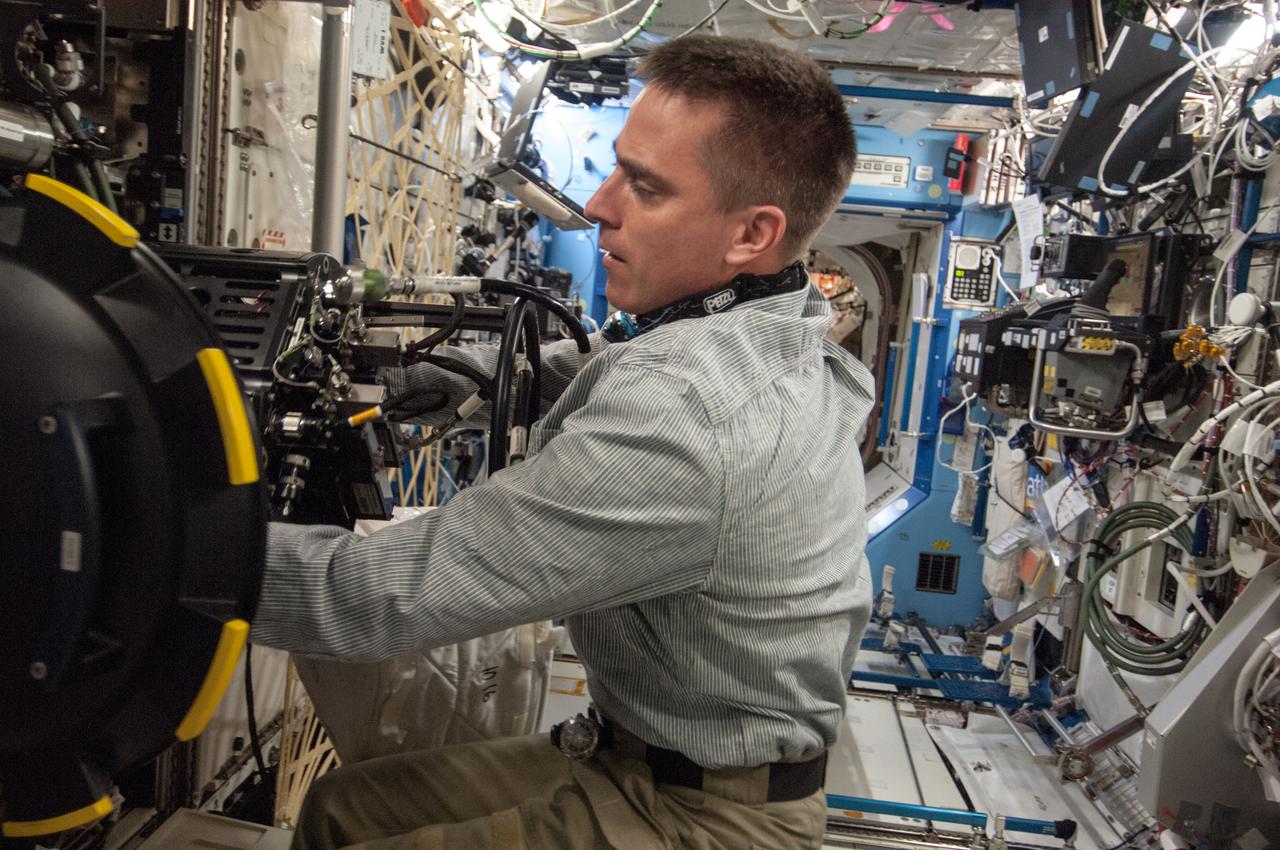
ISS035-E-017699 (10 April 2013) --- This is one of several photos documenting the Multi-user Droplet Combustion Apparatus (MDCA) Fuel Reservoir replacement. Here, Expedition 35 Flight Engineer Chris Cassidy removes and replaces one of the Fuel Reservoirs with the MDCA Chamber Insert Assembly (CIA) pulled partially out of the Combustion Chamber. The MDCA Fuel Reservoirs contain the liquid fuel used during droplet combustion experiments. This reservoir change-out was in support of the FLame EXtinguishment (FLEX)-2 experiment, scheduled to be executed by ground controllers.
ISS035-E-017699 (10 April 2013) --- This is one of several photos documenting the Multi-user Droplet Combustion Apparatus (MDCA) Fuel Reservoir replacement. Here, Expedition 35 Flight Engineer Chris Cassidy removes and replaces one of the Fuel Reservoirs with the MDCA Chamber Insert Assembly (CIA) pulled partially out of the Combustion Chamber. The MDCA Fuel Reservoirs contain the liquid fuel used during droplet combustion experiments. This reservoir change-out was in support of the FLame EXtinguishment (FLEX)-2 experiment, scheduled to be executed by ground controllers.
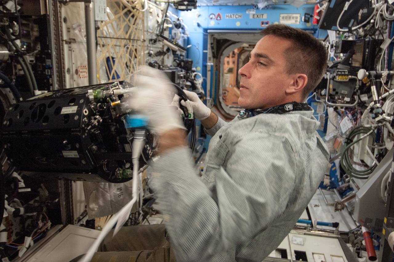
ISS035-E-017699 (10 April 2013) --- This is one of several photos documenting the Multi-user Droplet Combustion Apparatus (MDCA) Fuel Reservoir replacement. Here, Expedition 35 Flight Engineer Chris Cassidy removes and replaces one of the Fuel Reservoirs with the MDCA Chamber Insert Assembly (CIA) pulled partially out of the Combustion Chamber. The MDCA Fuel Reservoirs contain the liquid fuel used during droplet combustion experiments. This reservoir change-out was in support of the FLame EXtinguishment (FLEX)-2 experiment, scheduled to be executed by ground controllers.
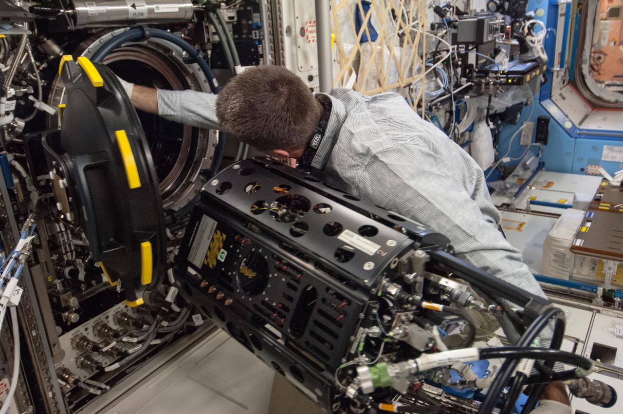
ISS035-E-017699 (10 April 2013) --- This is one of several photos documenting the Multi-user Droplet Combustion Apparatus (MDCA) Fuel Reservoir replacement. Here, Expedition 35 Flight Engineer Chris Cassidy removes and replaces one of the Fuel Reservoirs with the MDCA Chamber Insert Assembly (CIA) pulled partially out of the Combustion Chamber. The MDCA Fuel Reservoirs contain the liquid fuel used during droplet combustion experiments. This reservoir change-out was in support of the FLame EXtinguishment (FLEX)-2 experiment, scheduled to be executed by ground controllers.
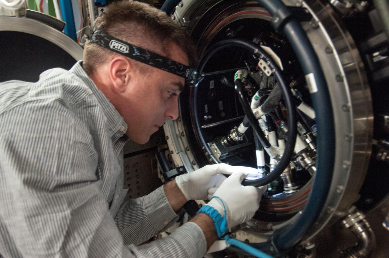
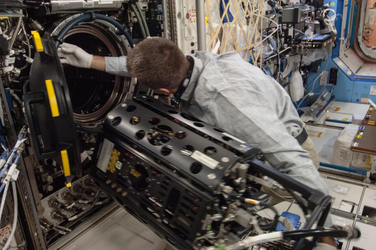
ISS035-E-017712 (10 April 2013)?-- This is one of several photos documenting the Multi-user Droplet Combustion Apparatus (MDCA) Fuel Reservoir replacement in the U.S. lab Destiny. Here, Expedition 35 Flight Engineer Chris Cassidy removes and replaces one of the Fuel Reservoirs with the MDCA Chamber Insert Assembly (CIA) pulled partially out of the Combustion Chamber. The MDCA Fuel Reservoirs contain the liquid fuel used during droplet combustion experiments. This reservoir change-out was in support of the FLame EXtinguishment (FLEX)-2 experiment, scheduled to be executed by ground controllers.
ISS035-E-017699 (10 April 2013) --- This is one of several photos documenting the Multi-user Droplet Combustion Apparatus (MDCA) Fuel Reservoir replacement. Here, Expedition 35 Flight Engineer Chris Cassidy removes and replaces one of the Fuel Reservoirs with the MDCA Chamber Insert Assembly (CIA) pulled partially out of the Combustion Chamber. The MDCA Fuel Reservoirs contain the liquid fuel used during droplet combustion experiments. This reservoir change-out was in support of the FLame EXtinguishment (FLEX)-2 experiment, scheduled to be executed by ground controllers.
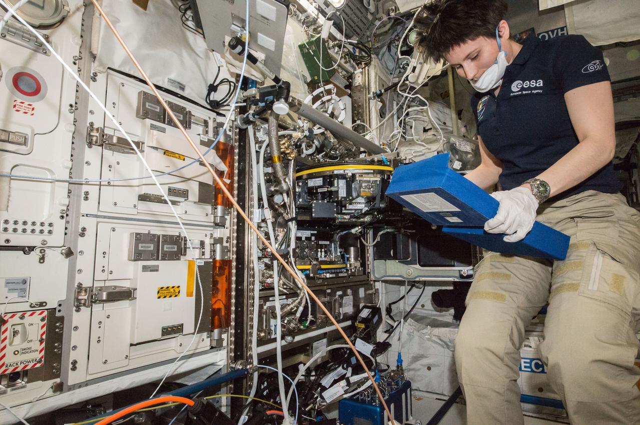
ISS043E127770 (04/14/2015) --- ESA (European Space Agency) astronaut Samantha Cristoforetti of Expedition 43 on the International Space Station works to remove a water removal reservoir on Apr.14, 2015. She and her crewmates also were removing all four European Modular Cultivation System rotor based life support systems to pack for their return to Earth on the upcoming SpaceX-6 spacecraft.
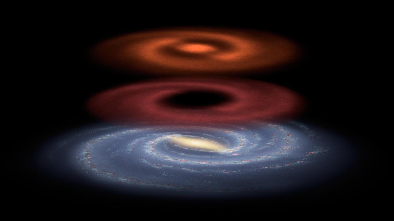
This illustration shows a newfound reservoir of stellar fuel discovered by the Herschel space observatory.
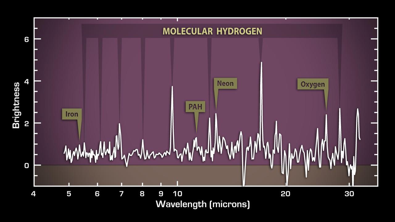
This plot of data from NASA Spitzer Space Telescope reveals vast reservoirs of hot gas in a galaxy about a billion light-years away called 3C 326 North.

This image from NASA Herschel, in the constellation of Vulpecula, shows an entire assembly line of newborn stars. The diffuse glow reveals the widespread cold reservoir of raw material that our Milky Way galaxy has in stock for building stars.
Crystals grown in the hand-held Protein Crystallization Apparatus for Microgravity (PCAM) onboard STS-61C. The PCAM has a pedestal in the center of a circular chamber, the surrounding chamber holds an absorbent reservoir that contains a solution of the precipitant. Vapor pressure differences between the protein solution and the reservoir solution force water to move from the protein solution to the reservoir. As protein concentrations increase, protein crystals begin to nucleate and grow.
Lake Mead, America's largest reservoir, on the Colorado River between Nevada and Arizona, has shrunk to historic lows, dropping to about 30% of its capacity. The reservoir provides water to 25 million people in California, Arizona, Nevada, and Mexico. The water level has fallen from 1204 feet in 2000, to an all-time low of 1049" yesterday. The images were acquired May 19, 2000 and May 25 2022, cover an area of 20.5 by 34.9 km, and are located at 36.1 degrees north, 114.6 degrees west. https://photojournal.jpl.nasa.gov/catalog/PIA25279
ISS016-E-011999 (22 Nov. 2007) --- Sao Simao Reservoir, Brazil is featured in this image photographed by an Expedition 16 crewmember on the International Space Station (ISS). The Sao Simao reservoir, near the confluence of the Rio Paranaiba and Rio Verde in Brazil, is the featured subject in a milestone image of Earth. This colorful, patchwork image is the 300,000th image of Earth downlinked from the space station. There are now over 745,000 images of Earth taken by astronaut crews, beginning with the Mercury missions in 1961 and continuing to the present day on the ISS. The Sao Simao reservoir is located on the border between the states of Goias and Minas Gerais (near the geographic coordinates of 18.7S 50.4W). Though the town of Sao Simao was founded around 1935, major growth occurred when the hydroelectric power plant and dam were built - forming the reservoir -- in 1975. The reservoir is part of a major navigation link that allows transport of goods and commerce between central Brazil, the Prata River and the South Atlantic. With 600,000 square kilometers of surface area, the reservoir also serves as a tourist destination for fishing, swimming and boating. In addition to hydroelectric power production, the economy of the region is based in agribusiness. The image highlights agricultural fields of various kinds and in different stages of cultivation. The major commodities include corn, soybeans, sesame seeds, sugarcane, beans, manioc, coffee and meat production.
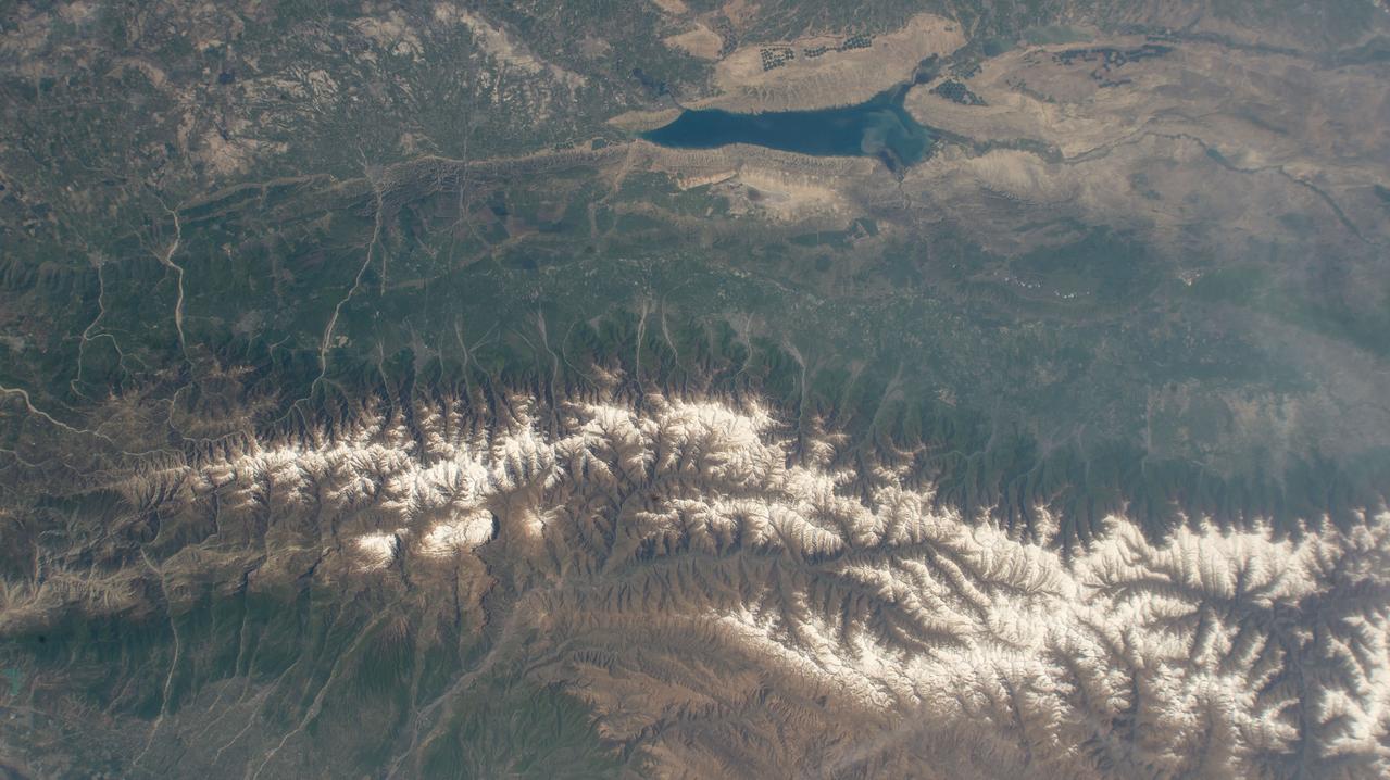
iss071e041651 (April 25, 2024) --- The snow-capped Caucasus Mountains run through Azerbaijan and Russia in this photograph from the International Space Station as it orbited 258 miles above. At top, is the Mingachevir Reservoir, the largest reservoir in the Caucasus and used for fishing, water supplies, and irrigation.
On March 26, New York Mayor Michael Bloomberg declared a drought emergency for the city and four upstate counties in response to the worst drought to hit the eastern United States in nearly 70 years. Restrictions on water use will affect more than 8 million residents of New York. The city's reservoirs, located in the Catskill Mountains, are at 52 percent capacity. One of these, Ashokan Reservoir, is seen in this pair of ASTER images acquired on September 18, 2000 and February 3, 2002. These images were acquired by the Advanced Spaceborne Thermal Emission and Reflection Radiometer (ASTER) on NASA's Terra satellite. With its 14spectral bands from the visible to the thermal infrared wavelength region, and its high spatial resolution of 15 to 90 meters (about 50 to 300 feet), ASTER will image Earth for the next 6 years to map and monitor the changing surface of our planet. http://photojournal.jpl.nasa.gov/catalog/PIA03491
Lake Mead, the largest reservoir in the US, has fallen to its lowest level ever. The water is a major source for such cities as Los Angeles and Las Vegas. With the predicted drought through this summer, the lake's water supply is expected to further shrink. In 2000, the lake was at its highest, and has declined ever since. The images were acquired June 14, 2021 and July 6, 2000, cover an area of 25.5 by 30 km, and are located at 36 degrees north, 114.7 degrees west. https://photojournal.jpl.nasa.gov/catalog/PIA24696
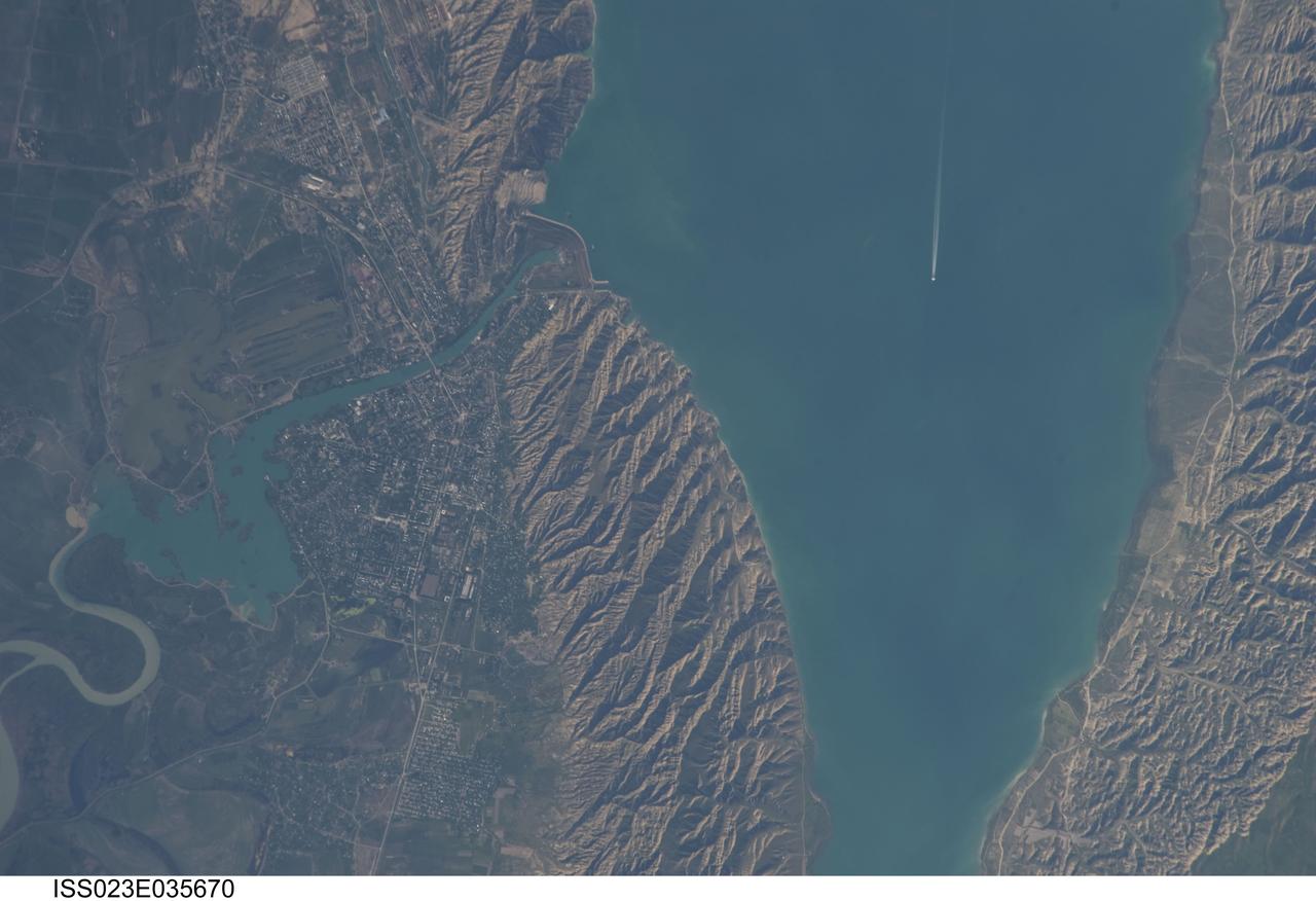
ISS023-E-035670 (8 May 2010) --- Mingachevir Reservoir, Azerbaijan is featured in this image photographed by an Expedition 23 crew member on the International Space Station. This detailed photograph highlights the southern Mingachevir Reservoir located in north-central Azerbaijan. The Mingachevir Reservoir occupies part of the Kura Basin, a topographic depression located between the Greater Caucasus Mountains to the northeast and the Lesser Caucasus Mountains to the southwest. According to scientists, folded layers of relatively young (less than 5.3 million years old) sedimentary rock, explosive volcanic products (ash and tuff), and unconsolidated sediments form the gray hills along the northern and southern shorelines of the reservoir (center and right). Afternoon sun highlights distinctive parallel patterns in the hills that are the result of water and wind erosion of different stratigraphic layers exposed at the surface. The nearby city of Mingachevir (left) is split by the Kur River after it passes through the dam and hydroelectric power station complex at top center. The current city was built in support of the hydroelectric power station constructed as part of the then Soviet Union?s energy infrastructure for the region. Today, Mingachevir is the fourth largest city in Azerbaijan (by population) and has become a cultural and economic center of the country. The reservoir held approximately 15 billion cubic meters of water at the time this image was taken, with a total engineered capacity of 16 billion cubic meters. The width of the reservoir illustrated here is approximately 8 kilometers; a jet flying over the reservoir and its contrail are visible midway between the opposing shorelines.
Chennai, India's sixth largest city, has seen no rain for over six months. Its four major reservoirs have virtually run dry, and the city's population of four million is mostly relying on government tankers to provide water, or paying private companies to supply water. The two images were acquired by ASTER on October 6, 2015, and Landsat OLI on June 3, 2019. They cover an area of 29.9 by 45.7 kilometers, and are centered at 13.1 degrees north, 80.3 degrees east. https://photojournal.jpl.nasa.gov/catalog/PIA23300
This image from NASA Terra spacecraft shows Shasta Lake in northern California, which has an area of 12,000 ha, making it the state largest reservoir. Impacts of the continuing drought in the western US is evident in the two ASTER images acquired 9 years apart. The images were acquired September 9, 2005 and September 2, 2014. They cover an area of 27.6 x 40.4 km, and are located at 40.6 degrees north, 122.4 degrees west. http://photojournal.jpl.nasa.gov/catalog/PIA19492
The ASTER instrument onboard Terra spacecraft imaged the toxic sludge spill in Hungary on Oct. 11, 2010. A million cubic meters 35 million cubic feet of red sludge spilled from a reservoir at an alumina plant in Ajka in western Hungary.
iss063e070632(Aug. 14, 2020) --- Shasta Lake, a reservoir in northern California, is pictured from the International Space Station as it orbited above the western United States.
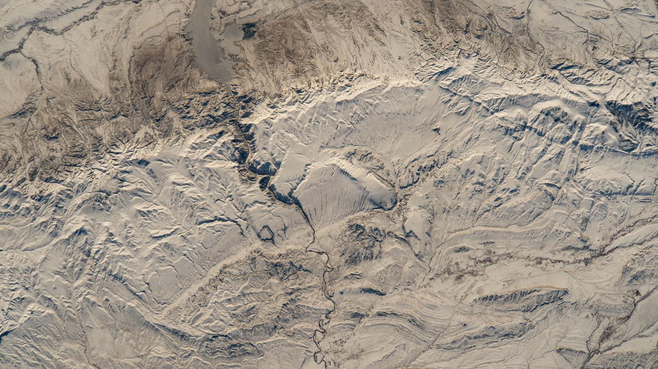
Lake Murray, a manmade reservoir, lies between the Fly and Strickland River Basins, Papua, New Guinea (7.0S, 141.5E). The region, photographed in sunglint, shows the water level in the reservoir and the full extent of the drainage basins of both river systems as the rivers meander through wide alluvial floodplains. Some forest clearing can be seen in places throughout the region, but most of the area remains in closed canopy forest.
AS09-21-3299 (3-13 March 1969) --- Dallas-Fort Worth area as photographed from the Apollo 9 spacecraft during its Earth-orbital mission. The superhighways leading out of two cities are clearly visible. The largest body of water north of Dallas is the Garza-Little Elm Reservoir. Cedar Creek Reservoir is located to the southeast of Dallas. The City of Denton is near left center edge of picture at junction of two highways leading from Fort Worth and Dallas.
jsc2023e055883 (10/5/2023) --- Oil is pushed back into the reservoir by a jet of air during the reset phase of the investigation. As the oil moves back into the reservoir, it leaves behind a thin liquid film. The Gaucho Lung investigation will study fluid transport within gel-coated tubes to learn more about treatment programs for respiratory distress syndrome and develop new contamination control strategies. Image courtesy of University of California, Santa Barbara.
ISS030-E-031663 (8 Jan. 2012) --- This photo showing the Manicouagan Reservoir in Quebec, Canada, was photographed by one of the Expedition 30 crew members aboard the International Space Station. The Manicouagan Reservoir marks the site of an impact crater, 60 miles (100 kilometers) wide, which, according to scientists, was formed 212 million years ago when a meteorite crashed into this area. Scientists say that over millions of years the many advancing and retreating glaciers and other erosional processes have worn down the crater.
jsc2023e055882 10/5/2023) --- Oil flows into a glass tube during the imbibition phase of the experiment. The oil is initially stored in a reservoir on the right side of the tube (not visible). When the reservoir is open, the oil spontaneously flows into the tube, driven by interfacial/capillary action. The Wicking in Gel-Coated Tubes (Gaucho Lung) investigation studies fluid transport within gel-coated tubes to learn more about treatment programs for respiratory distress syndrome and develop new contamination control strategies. Image courtesy of University of California, Santa Barbara.
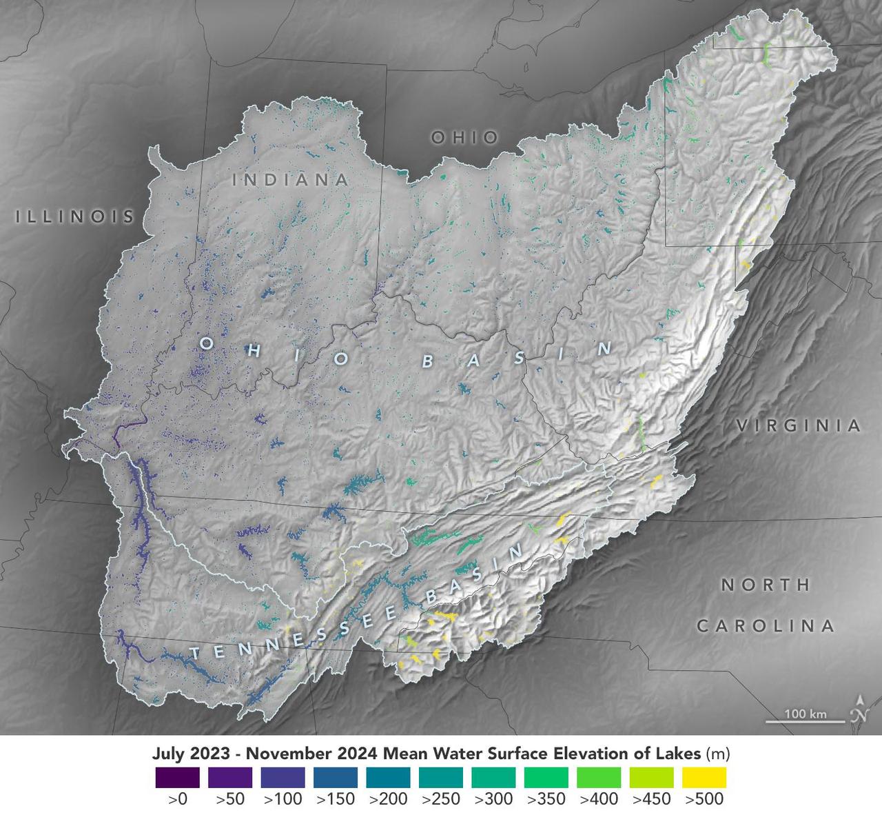
This visualization based on data from the Surface Water and Ocean Topography (SWOT) satellite shows the average water level for lakes and reservoirs in the Ohio River Basin from July 2023 to November 2024. Yellow indicates values greater than 1,600 feet (500 meters) above sea level, and dark purple represents water levels less than 330 feet (100 meters). Comparing how such levels change can help hydrologists measure water availability over time in a local area or across a watershed. Since early 2023, SWOT has been measuring the height of nearly all water on Earth's surface – including oceans, lakes, reservoirs, and rivers – covering nearly the entire globe at least once every 21 days. The satellite also measures the horizontal extent of water in freshwater bodies. Earlier this year, the SWOT mission started making validated data (processed measurements that have been checked for accuracy) publicly available. https://photojournal.jpl.nasa.gov/catalog/PIA26188
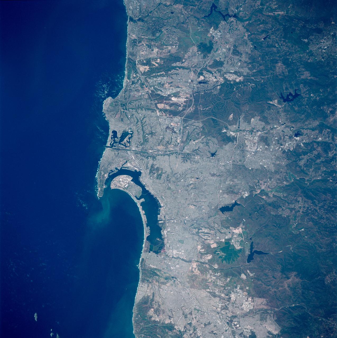
STS090-758-018 (17 April - 3 May 1998) --- The Space Shuttle Columbia was almost directly over the San Diego, California, area when this scene was captured with a 70mm handheld camera. In order for north to appear toward the top of the frame, it should be held with the Pacific Ocean waters to the left. The United States Naval Air Station, the United States Naval Training Center, United States Marine Corps (USMC) Recruit Depot and the United States Naval Station are all visible just left of center on or near the island and peninsula features. Among the many bodies of water visible in the photo are Mission Bay, San Diego Bay, Lower Otay Reservoir, Sweetwater Reservoir and El Capitan Reservoir.
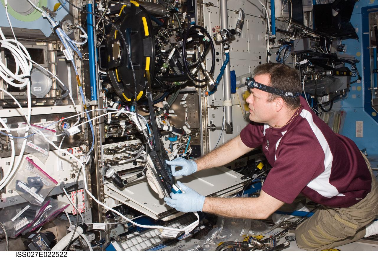
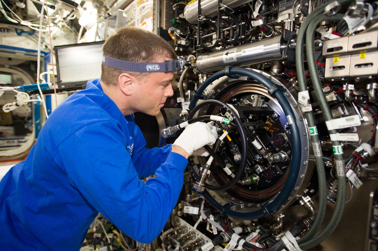
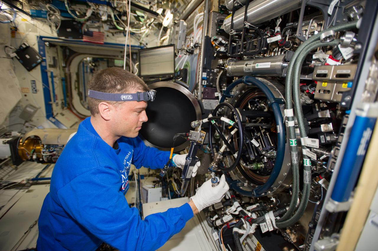
ISS027-E-022522 (5 May 2011) --- NASA astronaut Ron Garan, Expedition 27 flight engineer, services the Combustion Integrated Rack (CIR) Multi-user Drop Combustion Apparatus (MDCA) in the Destiny laboratory of the International Space Station.
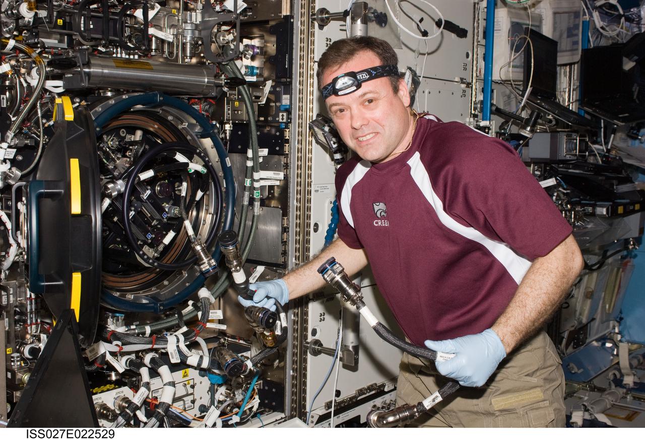
ISS027-E-022529 (5 May 2011) --- NASA astronaut Ron Garan, Expedition 27 flight engineer, services the Combustion Integrated Rack (CIR) Multi-user Drop Combustion Apparatus (MDCA) in the Destiny laboratory of the International Space Station.
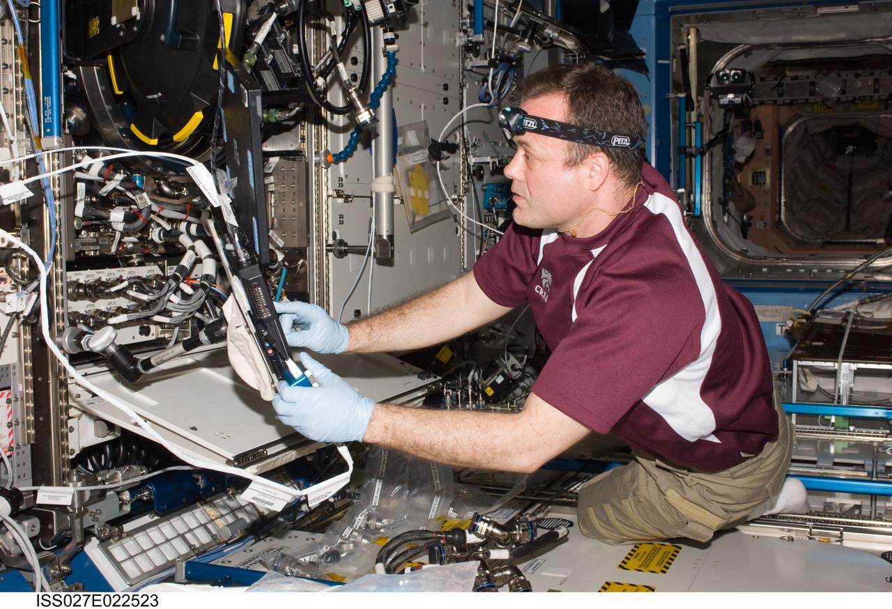
ISS027-E-022523 (5 May 2011) --- NASA astronaut Ron Garan, Expedition 27 flight engineer, services the Combustion Integrated Rack (CIR) Multi-user Drop Combustion Apparatus (MDCA) in the Destiny laboratory of the International Space Station.
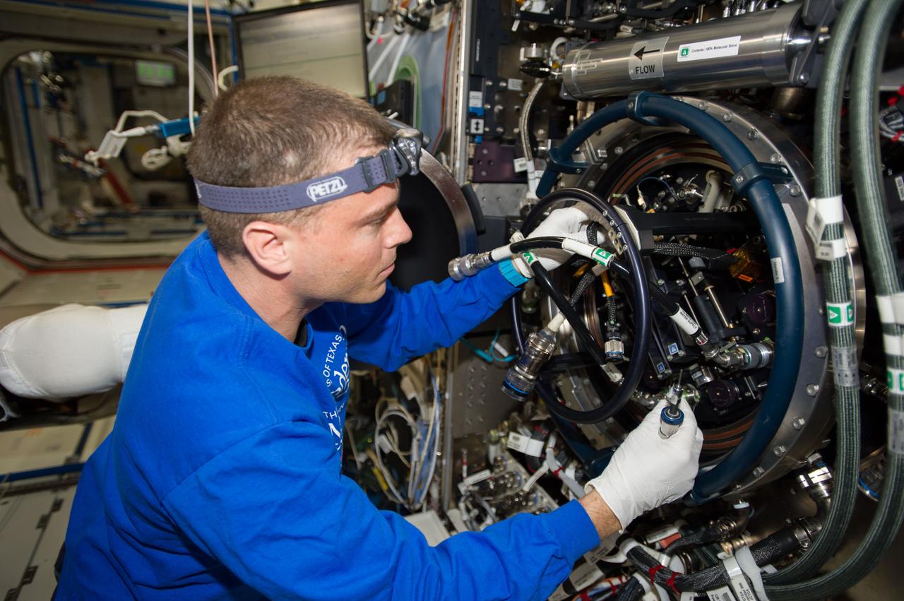
ISS040-E-090484 (11 Aug. 2014) --- NASA astronaut Reid Wiseman, Expedition 40 flight engineer, performs routine in-flight maintenance on the Multi-user Drop Combustion Apparatus (MDCA) inside the Combustion Integrated Rack (CIR) in the Destiny laboratory of the International Space Station. The MDCA contains hardware and software to conduct unique droplet combustion experiments in space.
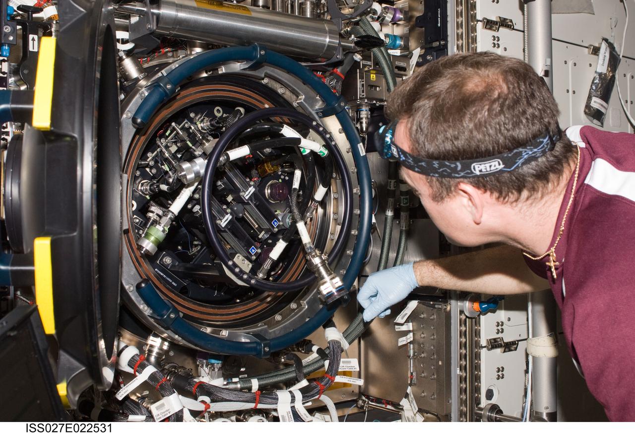
ISS027-E-022531 (5 May 2011) --- NASA astronaut Ron Garan, Expedition 27 flight engineer, services the Combustion Integrated Rack (CIR) Multi-user Drop Combustion Apparatus (MDCA) in the Destiny laboratory of the International Space Station.
ISS040-E-090493 (11 Aug. 2014) --- NASA astronaut Reid Wiseman, Expedition 40 flight engineer, performs routine in-flight maintenance on the Multi-user Drop Combustion Apparatus (MDCA) inside the Combustion Integrated Rack (CIR) in the Destiny laboratory of the International Space Station. The MDCA contains hardware and software to conduct unique droplet combustion experiments in space.
ISS040-E-090482 (11 Aug. 2014) --- NASA astronaut Reid Wiseman, Expedition 40 flight engineer, performs routine in-flight maintenance on the Multi-user Drop Combustion Apparatus (MDCA) inside the Combustion Integrated Rack (CIR) in the Destiny laboratory of the International Space Station. The MDCA contains hardware and software to conduct unique droplet combustion experiments in space.
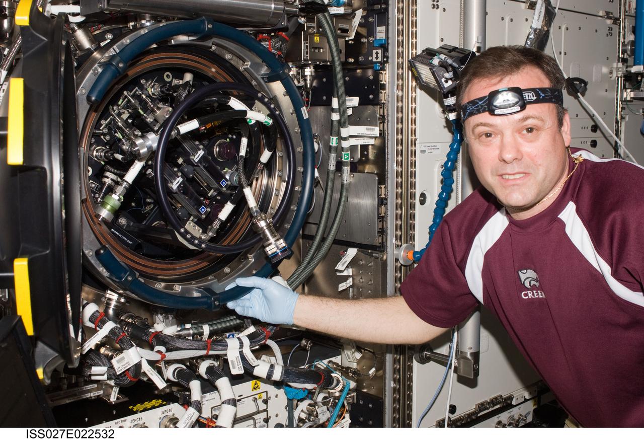
ISS027-E-022532 (5 May 2011) --- NASA astronaut Ron Garan, Expedition 27 flight engineer, services the Combustion Integrated Rack (CIR) Multi-user Drop Combustion Apparatus (MDCA) in the Destiny laboratory of the International Space Station.
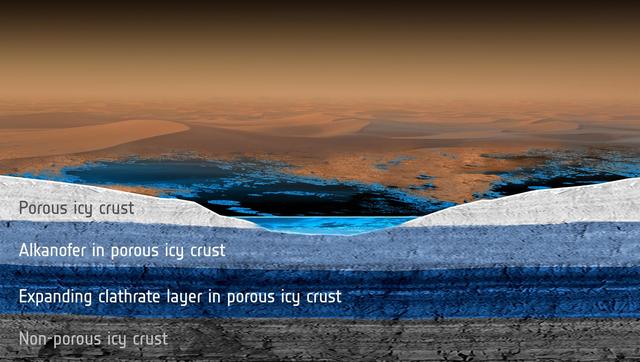
Scientists modeled how methane rainfall runoff would interact with the porous, icy crust of Saturn moon Titan and found that a subsurface methane aquifer might have its composition changed over time due to the formation of materials called clathrates.
ISS040-E-090497 (11 Aug. 2014) --- NASA astronaut Reid Wiseman, Expedition 40 flight engineer, performs routine in-flight maintenance on the Multi-user Drop Combustion Apparatus (MDCA) inside the Combustion Integrated Rack (CIR) in the Destiny laboratory of the International Space Station. The MDCA contains hardware and software to conduct unique droplet combustion experiments in space.
iss061e004462 (Oct. 8, 2019) --- The Mattmarksee, a reservoir built in the early 1960's between the Rimpfischhorn and Stellihorn mountains in the Swiss Alps, was photographed from the International Space Station at an altitude of 253 miles above Switzerland.
iss061e004461 (Oct. 8, 2019) --- The Rhône river, Réservoir du Grande-Large and the Groupama Stadium are pictured just east of the French city of Lyon as the International Space Station orbited 253 miles above the European nation.

iss063e028234 (June 16, 2020) --- Lake Nasser, a vast reservoir in southern Egypt and northern Sudan, is pictured from the International Space Station as it orbited above northeast Africa.
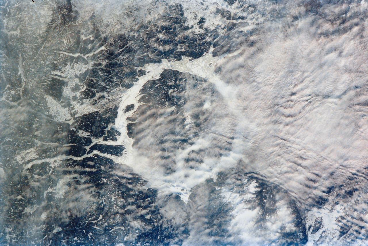
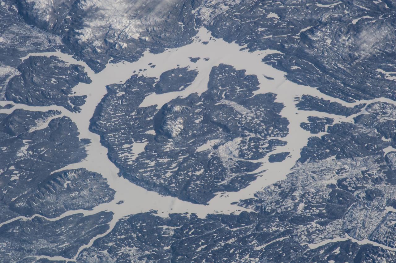
iss066e141220 (Feb. 13, 2022) --- The icy terrain surrounding the Manicouagan Reservoir, a lake formed by a prehistoric meteorite impact, is pictured from the International Space Station as it orbited 261 miles above far eastern Canada.

iss060e004214 (July 4, 2019) --- Lake Isabella in California, pictured as the International Space Station orbited 256 miles above the Golden State, is a reservoir formed in 1953 when the Kern River was dammed by the U.S. Army Corps of Engineers.
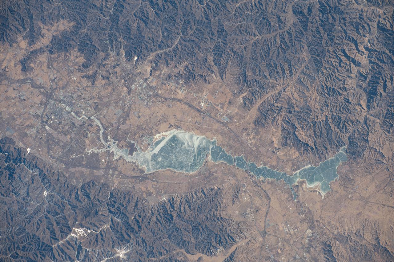
iss070e093517 (Feb. 15, 2024) --- The Guanting Reservoir, northwest of Beijing, China, and surrounded by several smaller cities, is pictured from the International Space Station as it orbited 262 miles above.
iss069e015083 (May 31, 2023) --- Lake Assad in Syria, a reservoir on the Euphrates River, is pictured from the International Space Station as it orbited 258 miles above the Middle East nation.
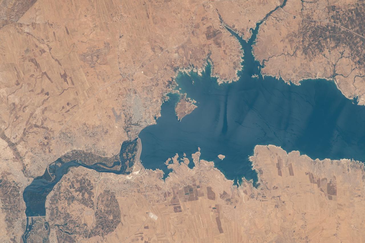
iss068e006715 (Oct. 1, 2022) --- This portion of the Euphrates River, containing the Keban Dam Reservoir created by the Keban Dam, is pictured in eastern Turkey from the International Space Station as it orbited 260 miles above.

iss072e069220 (Oct. 16, 2024) --- The Jebba Dam (lower left) impounds the Niger River creating a reservoir in Nigeria in this photograph from the International Space Station as it orbited 259 miles above the African nation.
iss068e030993 (Dec. 17, 2022) --- A snow-covered Boysen State Park and a frozen Boysen Reservoir in Wyoming are pictured from the International Space Station as it orbited 261 miles above the western United States.
iss067e147538 (June 22, 2022) --- Old Baldy Mountain peak (bottom right) and Dead Man's Basin Reservoir (top) in Montana are pictured from the International Space Station as it orbited 264 miles above North America.
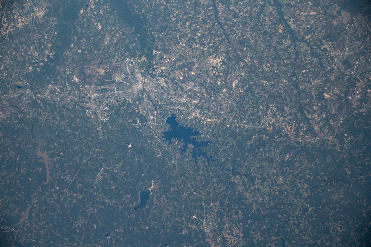
iss059e122299 (June 21, 2019) --- The Monticello Reservoir, Lake Murray and Columbia, South Carolina are pictured as the International Space Station orbited above the Atlantic Coastal Plain of the United States at an altitude of 256 miles.
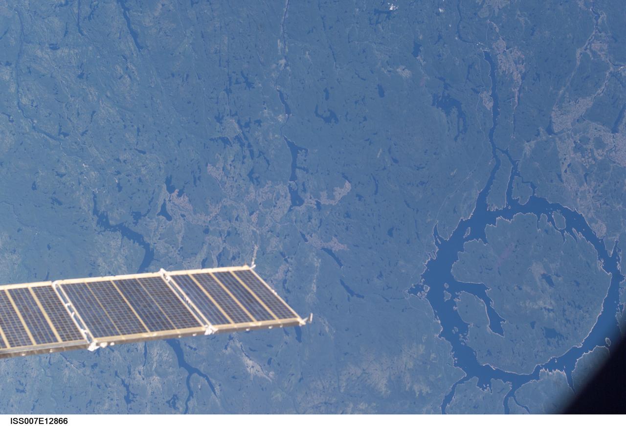
ISS007-E-12866 (17 August 2003) --- This photo showing the Manicouagan Reservoir in Quebec, Canada, and a partial view of a solar array panel was taken by an Expedition 7 crewmember onboard the International Space Station (ISS).
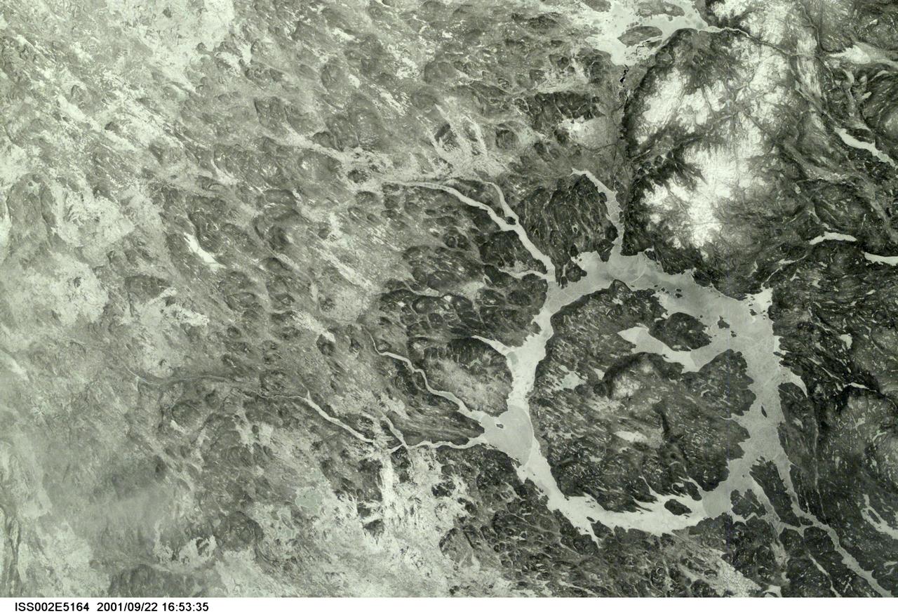
SS002-E-5164 (March 2001) --- The Manicouagan Impact Crater reservoir in Quebec, Canada, was photographed early in the mission by one of the Expedition Two crewmembers using a digital still camera.

iss071e130671 (May 26, 2024) --- Ute Reservoir in Utah, created by Ute Dam in New Mexico and filled by the Canadian River, is pictured frm the International Space Station as it orbited 262 miles above the southwestern United States.

iss070e004962 (Oct. 17, 2023) --- The São Francisco River passes through the Sobradinho Reservoir in Brazil in this photograph from the International Space Station as it orbited 259 miles above the South American nation.

iss066e091596 (Nov. 30, 2021) --- The Merowe Reservoir (center left) on the river Nile is pictured from the International Space Station as it orbited 262 miles above the African nation of Sudan.
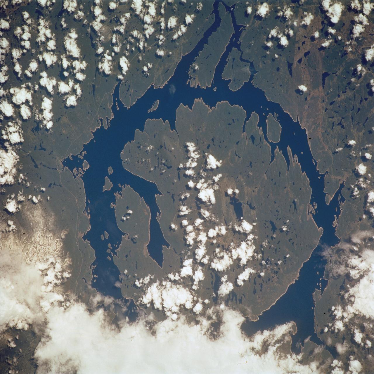
STS111-719-061 (5-19 June 2002) --- This photo showing the Manicouagan Reservoir in Quebec, Canada, was photographed by the STS-111 crewmembers aboard the Space Shuttle Endeavour. Manicouagan Reservoir marks the site of an impact crater, 60 miles (100 km) wide, which, according to scientists, was formed 212 million years ago when a meteorite crashed into this area. Scientists say that over millions of years the many advancing and retreating glaciers and other erosional processes have worn down the crater. The Gateway to Astronaut Photography of Earth (link to http://eol.jsc.nasa.gov/sseop/) provides searchable access to other photographs of Earth taken by astronauts.

AS06-02-1462 (4 April 1968) --- View of the Dallas-Fort Worth, Texas, area as photographed from the unmanned Apollo 6 (Spacecraft 020/Saturn 502) space mission. The highway and expressway system in and around both cities is clearly visible. North is toward left side of picture. Grapevine Reservoir and Garza-Little Elm Reservoir are to the north-west of Dallas. The city of Denton can be seen in left center of picture at conjunction of highways leading to both Fort Worth and Dallas. The Brazos River is in lower right corner. This photograph was made three hours and nine minutes after liftoff of the Apollo 6 space flight.

ISS019-E-007720 (15 April 2009) --- Three Gorges Dam in China is featured in this image photographed by an Expedition 19 crew member on the International Space Station. A new reservoir is filling in central China. The Three Gorges Dam on the Yangtze River - the world?s largest dam ? was completed in 2006, and the river is filling up its valley behind the dam to form a narrow reservoir extending more than 600 kilometers. This image is one of the first images documenting the flooding behind the dam. The main objective for the dam is to supply water for the largest hydroelectric plant in the world and help control the devastating floods that plague the lowlands downstream from the dam.
S66-45763 (18-21 July 1966) --- Don Martin Reservoir and Sabinas River Valley area of the States of Coahuila and Nuevo Leon, Mexico, as seen from the Gemini-10 spacecraft. Taken with a J. A. Maurer 70mm camera, using Eastman Kodak, Ektachrome, MS (S.O. 217) color film. Photo credit: NASA
iss069e000989 (April 6, 2023) --- An icy Qinghai Lake (right) and Longyang Gorge Reservoir (top center) in southern China are pictured in this photograph from an external high definition camera on the International Space Station as it orbited 263 miles above.
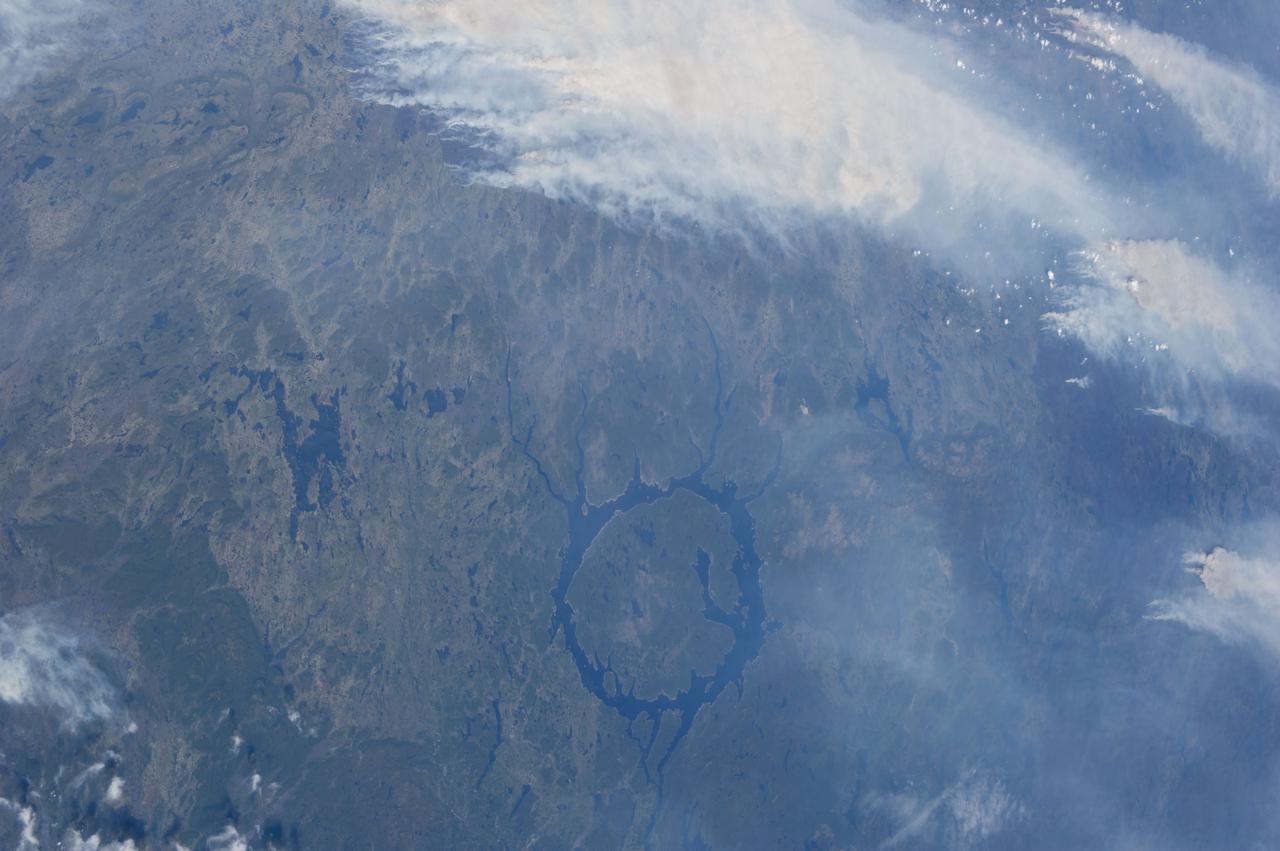
ISS036-E-015355 (4 July 2013) --- A number of Quebec, Canada wildfires near the Manicouagan Reservoir (seen at bottom center) were recorded in a series of photographs taken and downlinked to Earth on July 4 by the Expedition 36 crew members aboard the International Space Station.
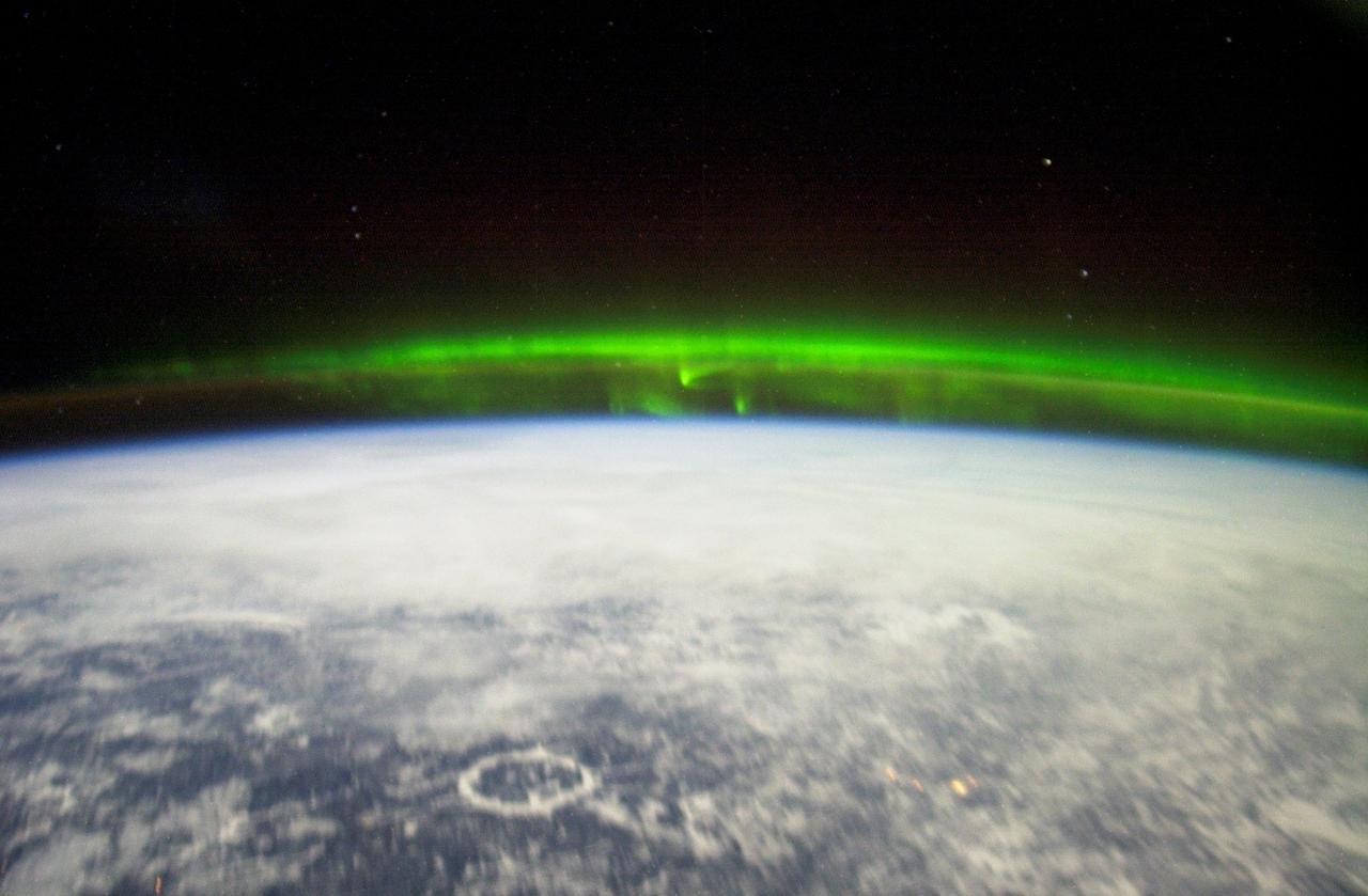
ISS006-E-18372 (January 2003) --- The Aurora Borealis or “northern lights” and the Manicouagan Impact Crater reservoir (foreground) in Quebec, Canada, were featured in this photograph taken by astronaut Donald R. Pettit, Expedition 6 NASA ISS science officer, on board the International Space Station (ISS).
ISS038-E-024145 (30 Dec. 2013) --- NASA astronaut Mike Hopkins, Expedition 38 flight engineer, performs in-flight maintenance on combustion research hardware in the Destiny laboratory of the International Space Station. Hopkins replaced a Multi-user Droplet Combustion Apparatus (MDCA) fuel reservoir inside the Combustion Integrated Rack (CIR).
iss060e000604 (June 26, 2019) --- The Murghab river flows into the oasis city of Mary in the Karakum Desert in Turkmenistan. At left, is the Hanhowuz Reservoir which plays an important role in agriculture in southeastern Turkmenistan. The International Space Station was orbiting 256 miles above the Central Asian nation when this photograph was taken.
iss066e125408 (Jan. 24, 2022) --- The Soyuz MS-19 crew ship and the Prichal docking module (in the background), with the river Nile and the Menowe Reservoir below, are pictured as the International Space Station orbited 258 miles above the African nation of Sudan.
ISS008-E-20656 (4 April 2004) --- This image featuring the Ukrainian city of Kiev on a reservoir on the Dnepr River was taken by an Expedition 8 crewmember on the International Space Station (ISS). Kiev is the capital of Ukraine and home to nearly three million people and rich in the history of western civilization.

ISS036-E-015354 (4 July 2013) --- A number of Quebec, Canada wildfires near the Manicouagan Reservoir (seen at lower left) were recorded as part of a series of photographs taken and downlinked to Earth on July 4 by the Expedition 36 crew members aboard the International Space Station.
iss068e029941 (Dec. 15, 2022) --- NASA astronaut and Expedition 68 Flight Engineer Josh Cassada works in the Kibo laboratory module filling water reservoirs on the Pant Habitat for a space botany study exploring the genetic changes plants may go through when adapting to microgravity.
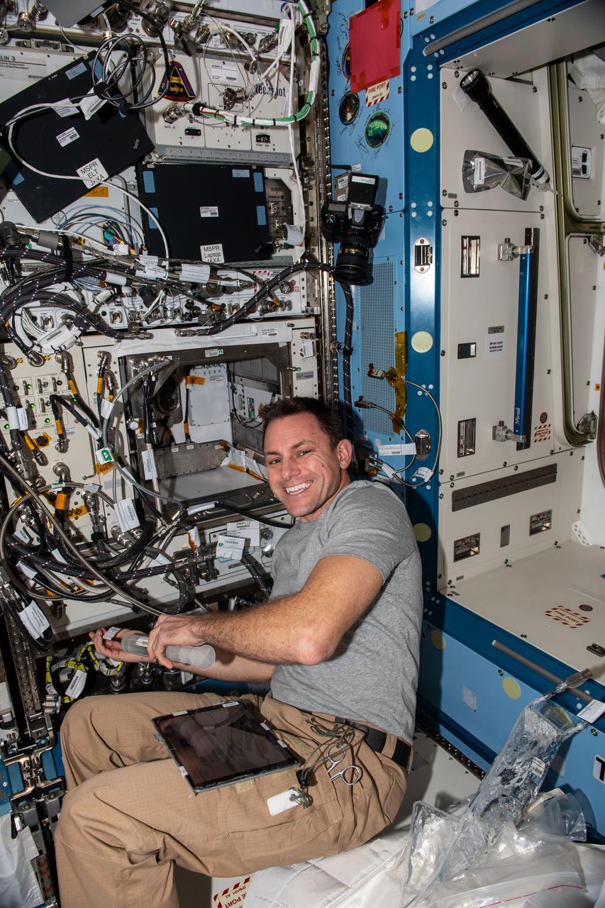
ISS019-E-007249 (16 April 2009) --- Japan Aerospace Exploration Agency (JAXA) astronaut Koichi Wakata, Expedition 19/20 flight engineer, performs in-flight maintenance on equipment in the Kibo laboratory of the International Space Station.
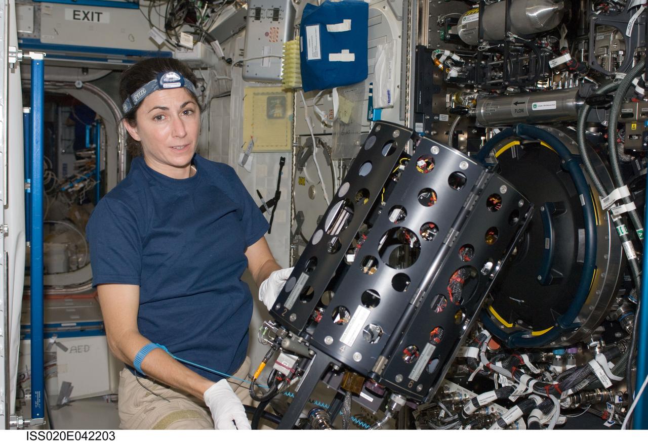
ISS020-E-042203 (26 Sept. 2009) --- NASA astronaut Nicole Stott, Expedition 20 flight engineer, works with the Combustion Integrated Rack (CIR) in the Destiny laboratory of the International Space Station.
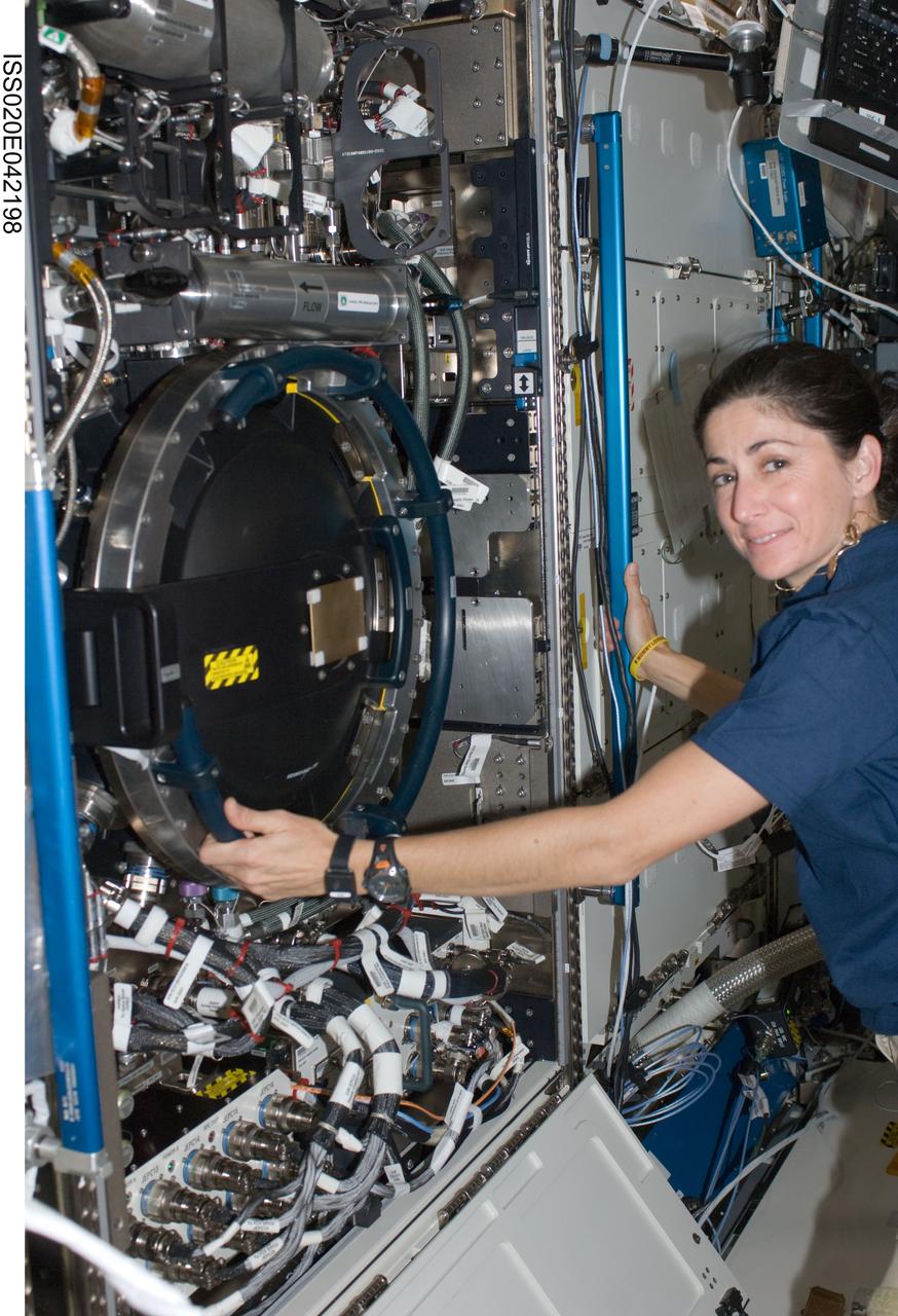
ISS020-E-042198 (26 Sept. 2009) --- NASA astronaut Nicole Stott, Expedition 20 flight engineer, works with the Combustion Integrated Rack (CIR) in the Destiny laboratory of the International Space Station.
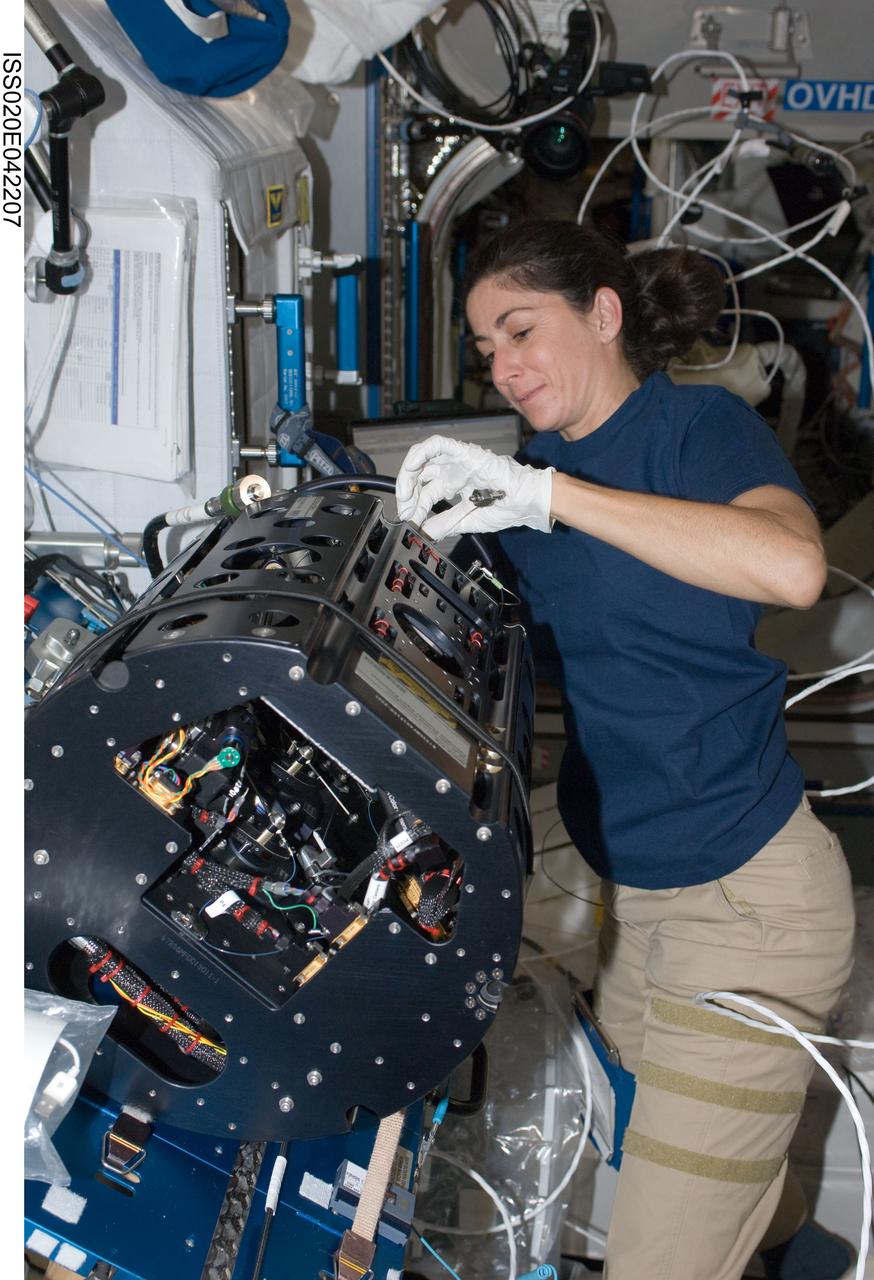
ISS020-E-042207 (26 Sept. 2009) --- NASA astronaut Nicole Stott, Expedition 20 flight engineer, works with the Combustion Integrated Rack (CIR) in the Destiny laboratory of the International Space Station.
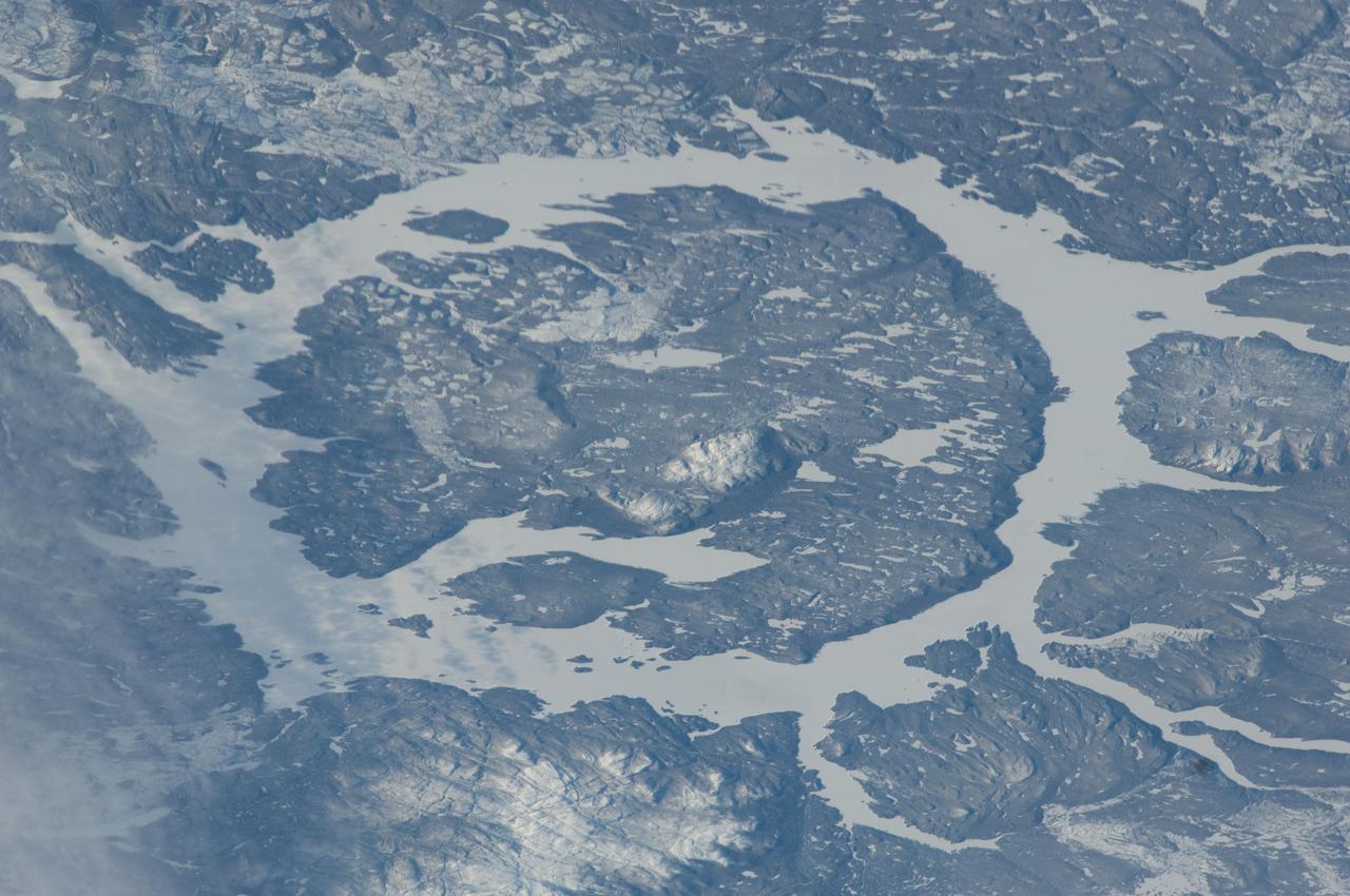
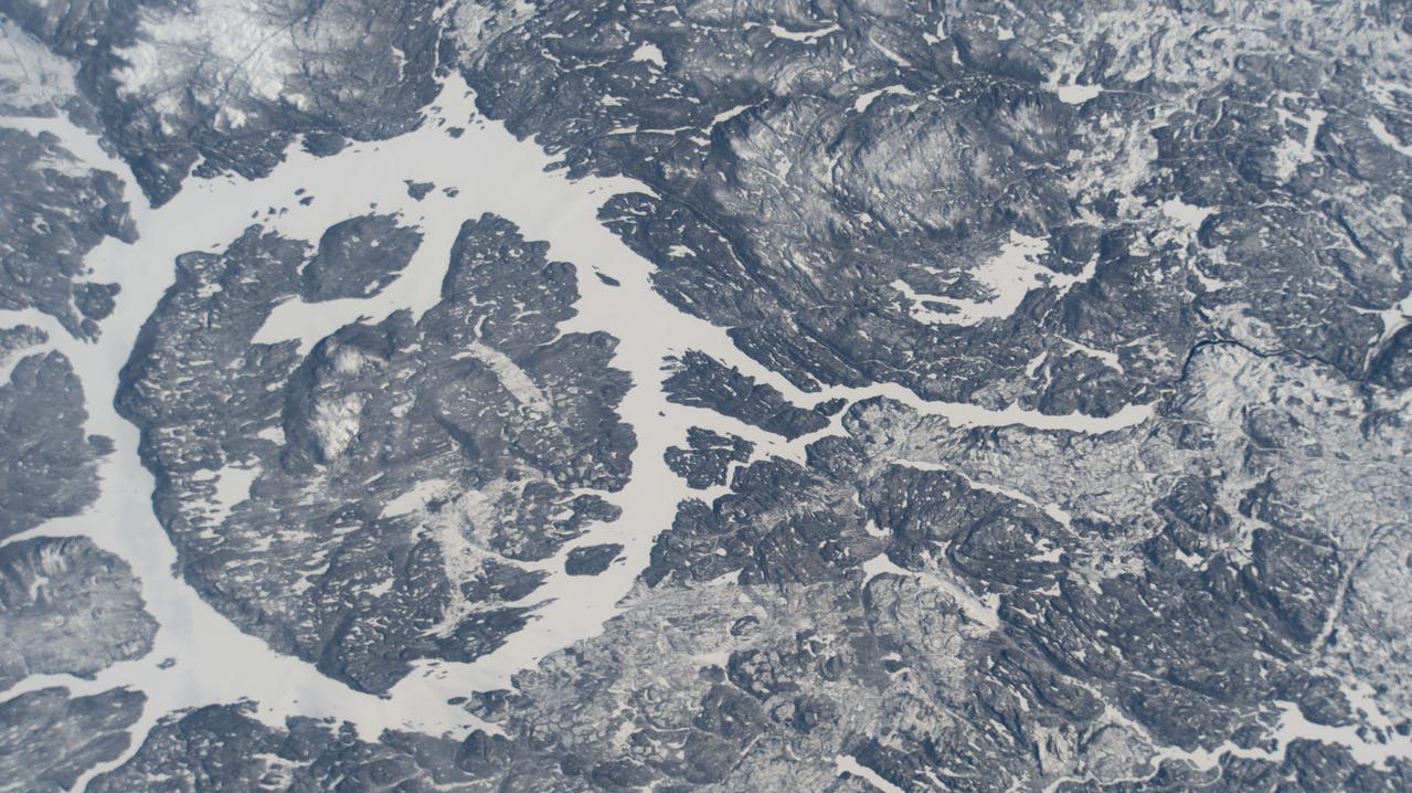
ISS038-E-025350 (2 Jan. 2014) --- One of the Expedition 38 crew members aboard the Earth-orbiting International Space Station recorded this image which features the Manicouagan Crater and reservoir located primarily in Manicouagan Regional County Municipality in the Cote-Nord region of Quebec, Canada. Scientists believe the crater was caused by the impact of a 5 kilometer (3 mile) diameter asteroid about 215.5 million years ago (Triassic Period). The crater is a multiple-ring structure about 100 kilometers (60 miles) across, with its 70 kilometer (40 mile) diameter inner ring as its most prominent feature; it contains a 70 kilometer (40 mile) diameter annular lake, the Manicouagan Reservoir, surrounding an inner island plateau, Rene-Levasseur Island. Because it is so unique and easily recognizable from the sky and space, the crater has been the subject of hundreds of images from astronauts for 45-plus years.

ISS008-E-12372 (10 January 2004) --- The Biobio River in Chile was featured in this image photographed by an Expedition 8 crewmember onboard the International Space Station (ISS). The river flows northwestward from the high Cordillera of the Andes to the Pacific Ocean near Concepcion, about 450 kilometers south of Santiago. This image shows a section of the river that skirts around Antuco volcano in the Andes, and features the Pangue dam and reservoir filling a narrow, meandering segment of the Biobio River valley. Upstream from the Pangue Reservoir (right frame), the cleared areas associated with earth moving and construction of the Ralco Dam are visible. The straight white lines in cleared forest between the two dams probably represent power transmission lines.
S73-35080 (July-September 1973) --- A vertical view of northeast Oklahoma and the metropolitan Tulsa area is seen in this Skylab 3 Earth Resources Experiments Package S190-B (five-inch Earth terrain camera) photograph taken from the Skylab space station in Earth orbit. THE PICTURE SHOULD BE HELD WITH THE CLOCK ON THE LEFT AND THE LAKE IN THE CORNER ON THE RIGHT. THE LONG STRETCH OF HIGHWAY (U.S. 75) RUNS STRAIGHT NORTH FROM TULSA. Tulsa, a rapidly expanding city in the heart of the mid-continent oil field, has a population of approximately 330,000. The Arkansas River meanders across the southern (lower) portion of the photograph passing through Tulsa as it flows southeastward. Oologah Reservoir, the long body of water, is located northeast of Tulsa. Lake Hudson is the body of water in the right corner of the picture. Keystone Reservoir is to the west and upstream from Tulsa. Westward from Tulsa U.S. 64 makes a 45 degree bend as it turns northwest to cross the Keystone Reservoir. The thin white line over the Oologah Reservoir is a highway bridge. Bartlesville is on U.S. 75 near the north (top) corner of the picture. The Tulsa International Airport is immediately northeast of downtown Tulsa. Several smaller airfields are visible in the surrounding area. The toll roads and other major highways are clearly visible in the picture. Claremore is northeast of Tulsa on U.S. 66 with the Will Rogers Turnpike passing nearby. Sapulpa is southwest of Tulsa on the Turner Turnpike which leads toward Oklahoma City. The detailed information contained in this photograph can be extracted by direct observation and applied to updating land use and cultural maps of Tulsa and to numerous surrounding satellite cities. All EREP photography is available to the public through the Department of Interior?s Earth Resources Observations Systems Data Center, Sioux Falls, South Dakota, 57198. (Alternate number SL3-83-206) Photo credit: NASA
This illustration depicts the Surface Water and Ocean Topography (SWOT) satellite, a mission led by NASA and the French space agency Centre National d'Études Spatiales (CNES). The scientific heart of the SWOT satellite is the Ka-band Radar Interferometer (KaRIn) instrument, which will measure the height of water in Earth's lakes, rivers, reservoirs, and ocean. To do that, KaRIn will transmit radar pulses to Earth's surface and use two antennas – seen to the left and right of the spacecraft bus – to triangulate the return signals that bounce back. Mounted at the ends of a boom 33 feet (10 meters) long, the antennas will collect data over two swaths of Earth's surface at a time, each of them 30 miles (50 kilometers) wide and located on either side of the satellite. KaRIn will operate in two modes: A lower-resolution mode over the ocean will involve significant onboard processing of the data to reduce the volume of information sent during downlinks to Earth; a higher-resolution mode will be used mainly over land. https://photojournal.jpl.nasa.gov/catalog/PIA25621
This illustration depicts the Surface Water and Ocean Topography satellite, a mission led by NASA and the French space agency Centre National d'Études Spatiales (CNES). The scientific heart of the SWOT satellite is the Ka-band Radar Interferometer (KaRIn) instrument, which will measure the height of water in Earth's lakes, rivers, reservoirs, and ocean. To do that, KaRIn will transmit radar pulses to Earth's surface and use two antennas – seen to the left and right of the spacecraft bus – to triangulate the return signals that bounce back. Mounted at the ends of a boom 33 feet (10 meters) long, the antennas will collect data over two swaths of Earth's surface at a time, each of them 30 miles (50 kilometers) wide and located on either side of the satellite. KaRIn will operate in two modes: A lower-resolution mode over the ocean will involve significant onboard processing of the data to reduce the volume of information sent during downlinks to Earth; a higher-resolution mode will be used mainly over land. https://photojournal.jpl.nasa.gov/catalog/PIA24530

iss059e038845 (5/2/2019) --- Canadian Space Agency (CSA) astronaut David Saint-Jacques is photographed performing a reservoir fill on the Veggie Ponds facility in the Columbus module of the International Space Station (ISS). The primary goal of the Veggie PONDS hardware validation test is to demonstrate plant growth in a newly developed plant growing system, Passive Orbital Nutrient Delivery System (PONDS).
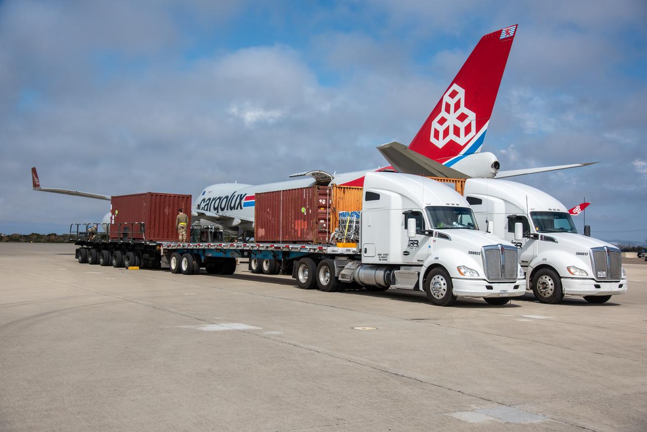
The ground service equipment for the Surface Water and Ocean Topography (SWOT) satellite arrives at Vandenberg Space Force Base in California on Oct. 13, 2022. SWOT is the first mission that will observe nearly all water on Earth’s surface, measuring the height of water in the planet’s lakes, rivers, reservoirs, and the ocean. The satellite is set to launch aboard a SpaceX Falcon 9 rocket in December from Vandenberg’s Space Launch Center-4 East. NASA’s Launch Services Program, based at the agency’s Kennedy Space Center in Florida, is managing the launch service.
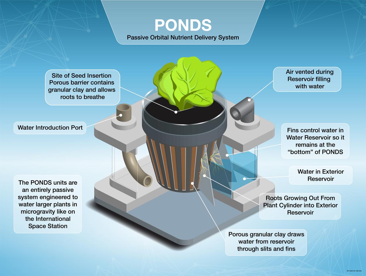
Infographic illustrating the Passive Orbital Nutrient Delivery System (PONDS) plant growth unit. The PONDS units are an entirely passive system – meaning no electricity, no pumps and no moving parts – and the basic concept involves using a free-standing reservoir of water that plants can draw from when needed, cutting down on time astronauts would spend watering plants during the growth interval.
The ground service equipment for the Surface Water and Ocean Topography (SWOT) satellite arrives at Vandenberg Space Force Base in California on Oct. 13, 2022. SWOT is the first mission that will observe nearly all water on Earth’s surface, measuring the height of water in the planet’s lakes, rivers, reservoirs, and the ocean. The satellite is set to launch aboard a SpaceX Falcon 9 rocket in December from Vandenberg’s Space Launch Center-4 East. NASA’s Launch Services Program, based at the agency’s Kennedy Space Center in Florida, is managing the launch service.
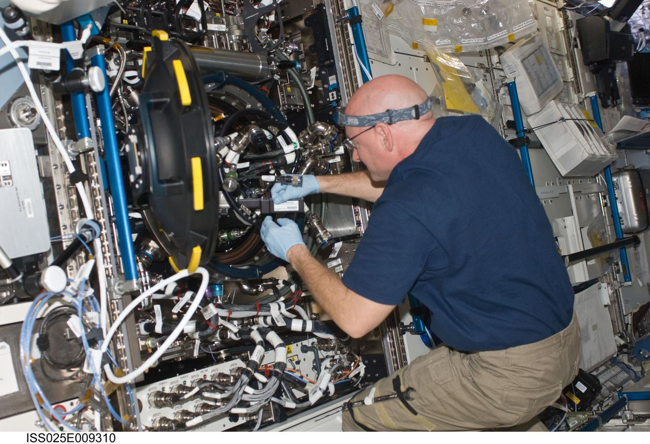
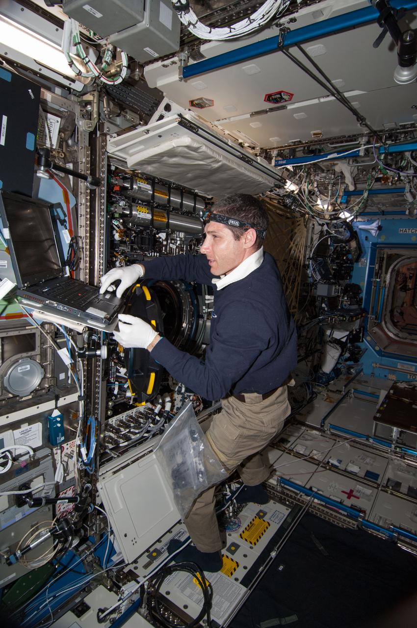
ISS025-E-009310 (26 Oct. 2010) --- NASA astronaut Scott Kelly, Expedition 25 flight engineer, works on the Combustion Integrated Rack (CIR) Multi-user Drop Combustion Apparatus (MDCA) in the Destiny laboratory of the International Space Station. Kelly set up an experiment run on the Fluids & Combustion Facility (FCF) with a new fuel reservoir, ground-assisted by Payload Operations Integration Center/Huntsville (POIC).
By August, 2024, the four dams blocking the flow of the Klamath River in California and Oregon were removed. After more than 100 years, nearly 640 km of salmon habitat were restored. Two of the dams and their reservoirs, Copco 1 and Copco 2 in northern California, are shown before and after removal. The images were acquired July 18, 2024 and August 15, 2020, cover an area of 16.5 by 22.5 km, and are located at 42.1 degrees north, 122.2 degrees west. https://photojournal.jpl.nasa.gov/catalog/PIA26448
ISS019-E-015910(12 May 2009) --- Japan Aerospace Exploration Agency (JAXA) astronaut Koichi Wakata, Expedition 19/20 flight engineer, works on the Combustion Integrated Rack (CIR) Multi-user Drop Combustion Apparatus (MDCA) in the Destiny laboratory of the International Space Station. Wakata removed and replaced one fuel reservoir, which required temporary opening the front end cap and removing the fuel supply bypass Quick Disconnect (QD).
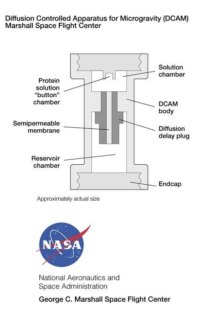
The Diffusion-Controlled Apparatus for Microgravity (DCAM) was developed at NASA's Marshall Space Flight Center. A semi-permeable plug or fuse at the center controls the rate at which a precipitant diffuses from the reservoir chamber into the solution chamber , thus prompting protein molecules in the solution to form crystals. The principal investigator is Dr. Dan Carter of New Century Pharmaceuticals in Huntsville, AL.

STS009-48-3139 (6 Dec 1983) --- A vertical view of the Manicouagan Impact Crater, some 300 miles (480 kilometers) north-northwest of Quebec City. The 50-mile (80 kilometers) diameter structure was left by a massive meteorite collision in the distant past. Untrue to the winter season, this picture is missing the conspicuous presence of ice on the Manicouagan Reservoir, which is created by the Daniel Johnson Dam.
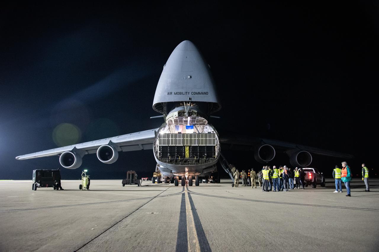
The Surface Water and Ocean Topography (SWOT) satellite arrives at Vandenberg Space Force Base in California on Oct. 16, 2022. SWOT is the first mission that will observe nearly all water on Earth’s surface, measuring the height of water in the planet’s lakes, rivers, reservoirs, and the ocean. The satellite is set to launch aboard a SpaceX Falcon 9 rocket in December from Vandenberg’s Space Launch Center-4 East. NASA’s Launch Services Program, based at the agency’s Kennedy Space Center in Florida, is managing the launch service.
ISS028-E-018657 (23 July 2011) --? One of the Expedition 28 crew members aboard the International Space Station photographed this northward looking view featuring the reservoir of Cahora Bassa in extreme western Mozambique, formed by damming the Zambezi River. Also visible are numerous plumes from fires in the wooded plateau region north of the lake on the Mozambique-Zambia frontier.

NASA Administrator Charles Bolden, left, and Centre National d'Études Spatiales (CNES) President Jean-Yves Le Gall talk after signing an agreement to move from feasibility studies to implementation of the Surface Water and Ocean Topography (SWOT) mission, Friday, May 2, 2014 at NASA Headquarters in Washington. The SWOT mission will use wide swath altimetry technology to produce high-resolution elevation measurements of the surface of lakes, reservoirs, and wetlands and of the ocean surface. Photo Credit: (NASA/Bill Ingalls)
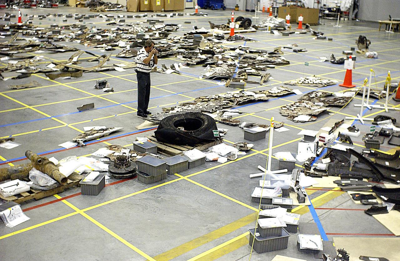
KENNEDY SPACE CENTER, FLA. - Pieces of Columbia debris are photographed by a KSC photographer. More than 70,000 items, weighing 78,000 pounds, about 36 percent of the Shuttle by weight, have been delivered to KSC for use in the mishap investigation. Ground teams have completed 78 percent of their primary search area, and airborne crews finished 80 percent of their assigned area. Search teams have completed 98 percent of the underwater searches in Lake Nacogdoches and Toledo Bend Reservoir.
SL2-81-157 (22 June 1973) --- This view of the Black Hills Region, SD (44.0N, 104.0W) shows the scenic Black Hills where Mt. Rushmore and other monuments are located. Cities and towns in this view include: Rapid City, Deadwood, and Belle Fourche with the nearby Belle Fourche Reservoir. Notable in this scene are the recovering burn scars (seen as irregular shaped light toned patches) from a 1959 forest fire in the Black Hills National Forest near the edge of the photo. Photo credit: NASA
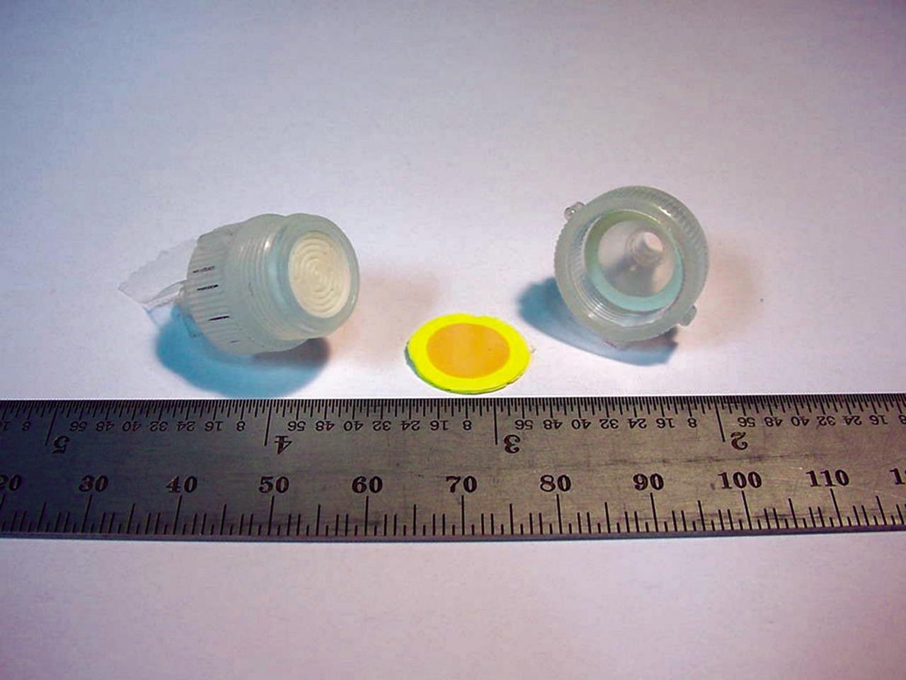
The heart of a colorimetric solid phase extractor (CSPE) test kit quickly measures the concentration of the biocides silver or iodine in astronauts’ drinking water to determine whether concentrations are safe. When 10 milliliters (ml) of water is drawn through the disk, the disk will turn color (yellow in this picture for iodine) indicating the presence of the biocides. The device could someday be used to test water safety at reservoirs and water treatment plants on Earth. (photo credit: Microanalytical Instrumentation Center, Iowa State University).
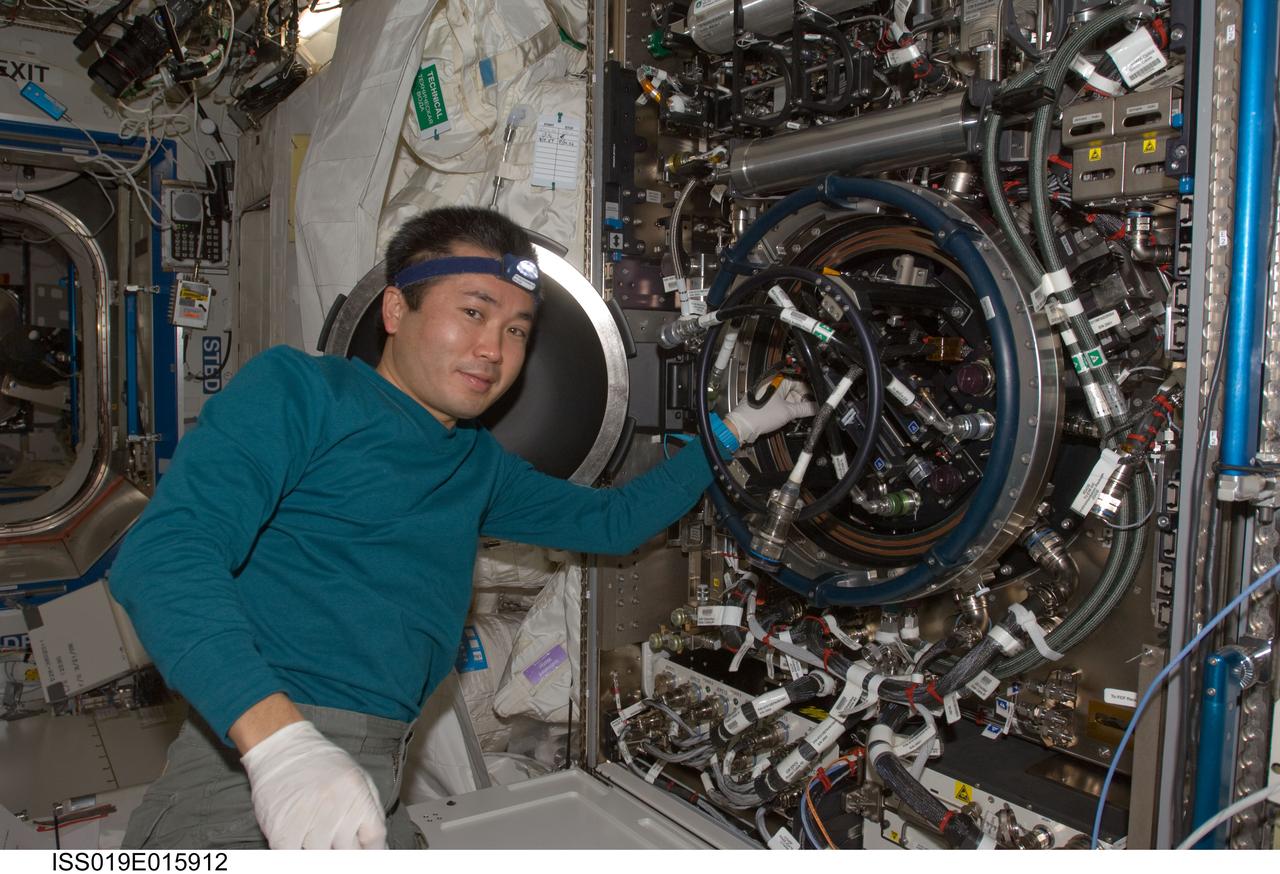
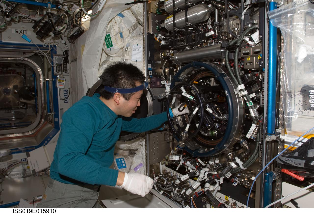
ISS019-E-015912 (12 May 2009) --- Japan Aerospace Exploration Agency (JAXA) astronaut Koichi Wakata, Expedition 19/20 flight engineer, works on the Combustion Integrated Rack (CIR) Multi-user Drop Combustion Apparatus (MDCA) in the Destiny laboratory of the International Space Station. Wakata removed and replaced one fuel reservoir, which required temporary opening the front end cap and removing the fuel supply bypass Quick Disconnect (QD).
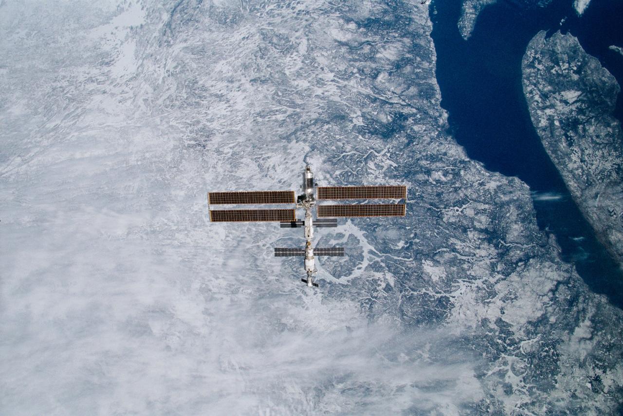
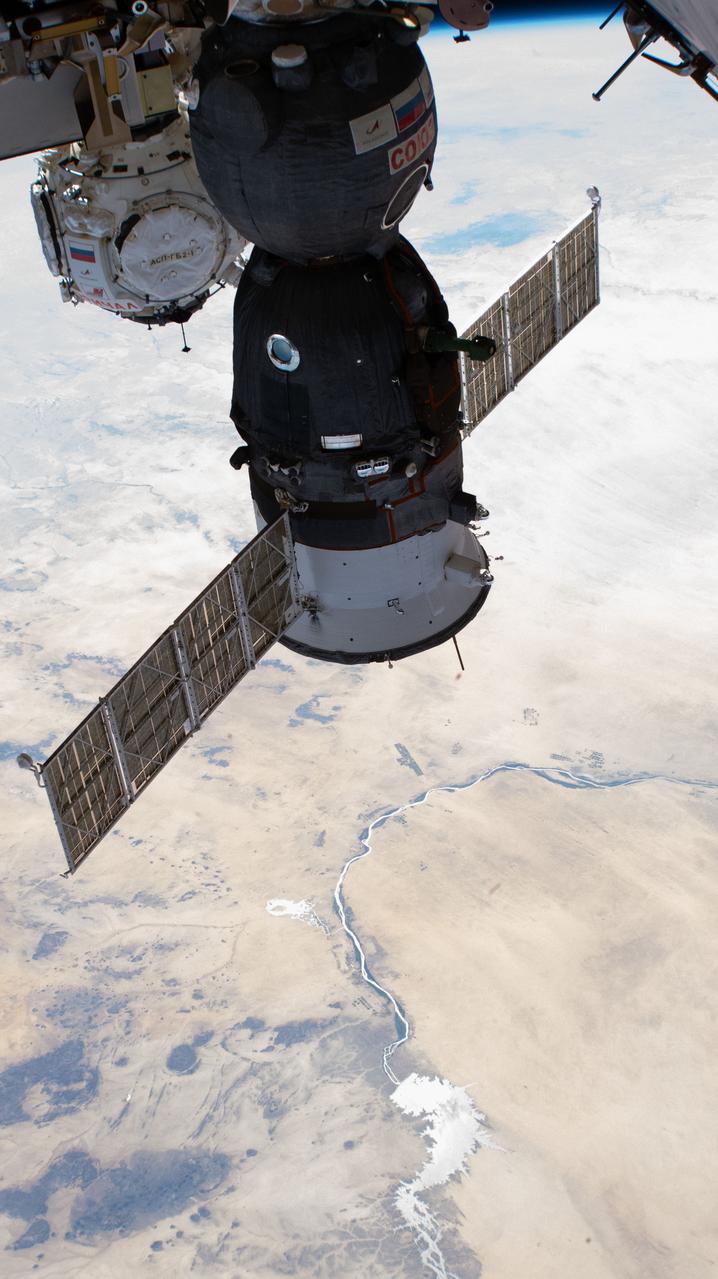
STS100-332-011 (29 April 2001) --- Backdropped against the topography of the Canadian province of Quebec, the International Space Station (ISS) was photographed following separation from the Space Shuttle Endeavour. An impact feature known as the Manicouagan Reservoir, is almost directly beneath the orbital outpost. The 35mm frame was exposed by one of the STS-100 crewmembers onboard the shuttle.