An Opportunity to Rise
The Sun Also Rises
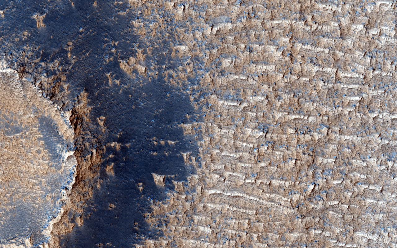
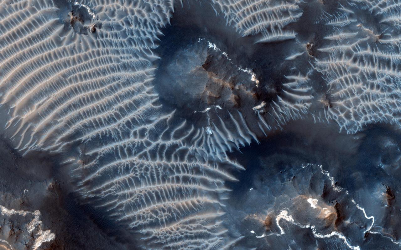
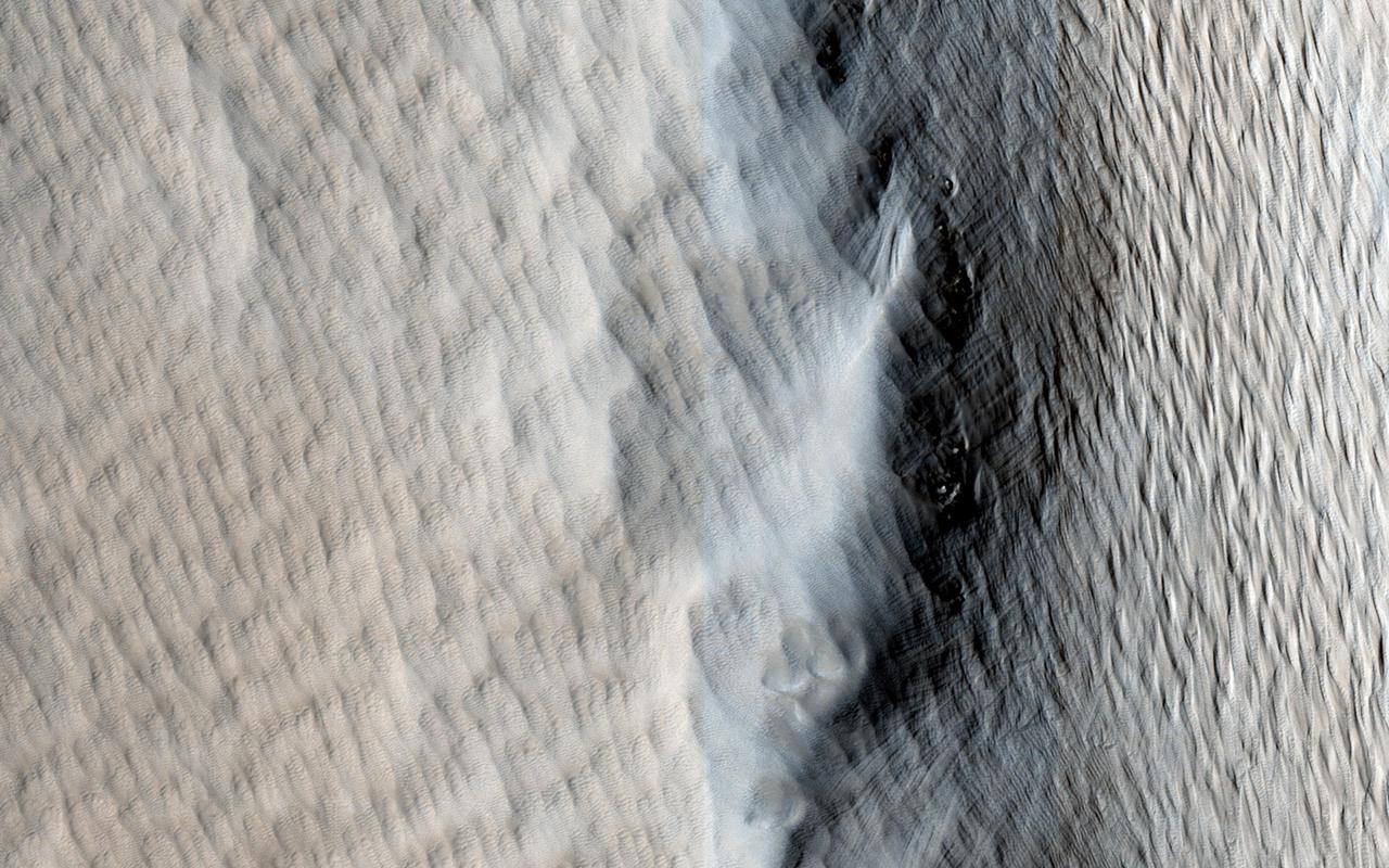
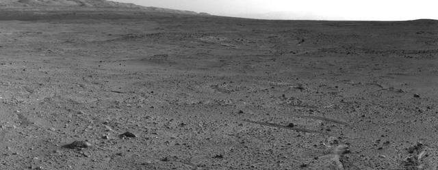
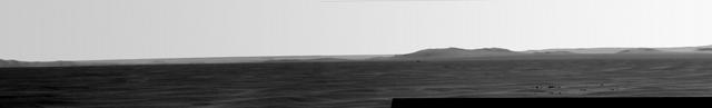
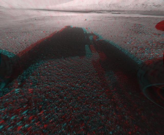
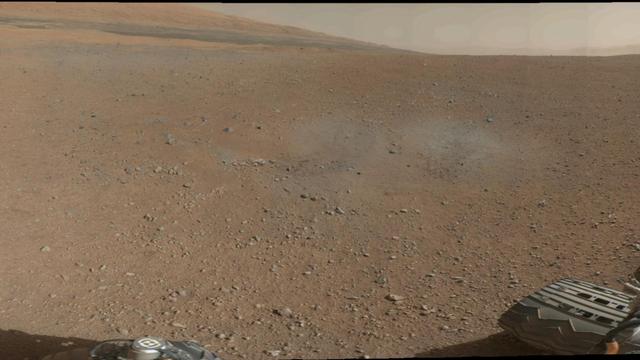
Martian Heat on the Rise
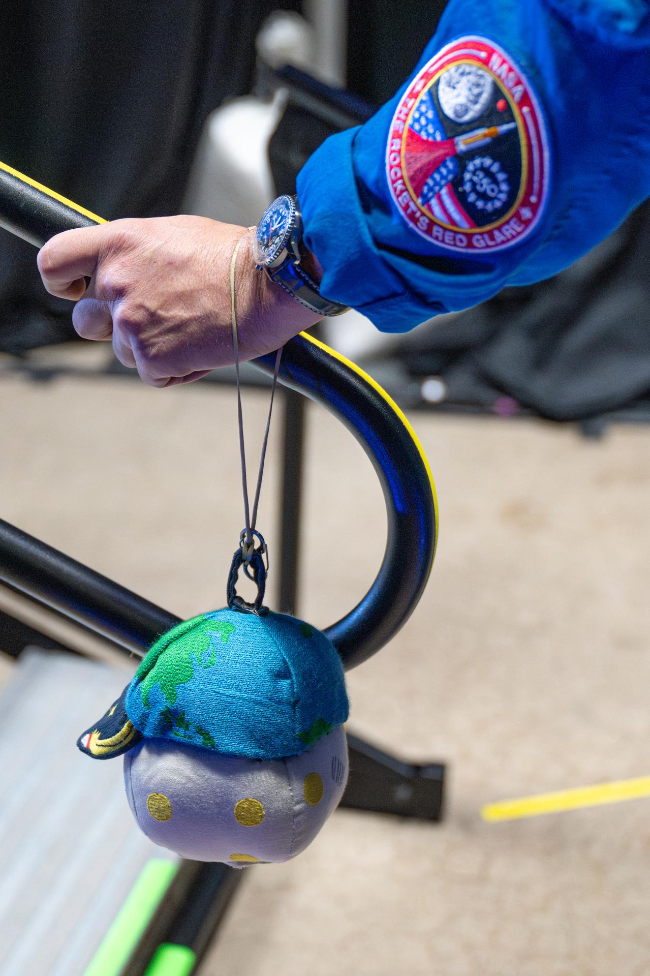
art002e009013 (April 4, 2026) - Artemis II Mission Specialist Christina Koch is seen through a window of the Orion spacecraft while on her way to the Moon. This selfie-style photo was taken using a camera on the end of one of Orion's solar array wings on flight day 4 of the approximately 10-day test flight, when Orion was more than halfway to the Moon. Koch is holding "Rise", the zero gravity indicator that launched with the crew after being selected from more than 2,600 original designs that were submitted from countries around the world. A zero gravity indicator is a small plush item that typically rides with a crew to visually indicate when they are in space. “Rise” was inspired by the iconic Earthrise moment from the Apollo 8 mission.
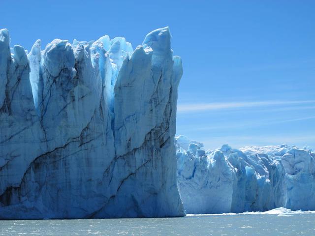
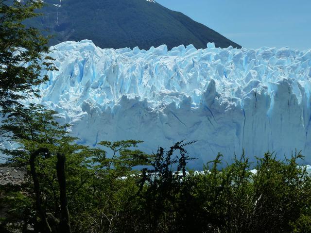
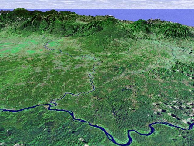
Calving front of the Perito Moreno Glacier (Argentina). Contrary to the majority of the glaciers from the southern Patagonian ice field, the Perito Moreno Glacier is currently stable. It is also one of the most visited glaciers in the world. To learn about the contributions of glaciers to sea level rise, visit: <a href="http://www.nasa.gov/topics/earth/features/glacier-sea-rise.html" rel="nofollow">www.nasa.gov/topics/earth/features/glacier-sea-rise.html</a> Credit: Etienne Berthier, Université de Toulouse <b><a href="http://www.nasa.gov/audience/formedia/features/MP_Photo_Guidelines.html" rel="nofollow">NASA image use policy.</a></b> <b><a href="http://www.nasa.gov/centers/goddard/home/index.html" rel="nofollow">NASA Goddard Space Flight Center</a></b> enables NASA’s mission through four scientific endeavors: Earth Science, Heliophysics, Solar System Exploration, and Astrophysics. Goddard plays a leading role in NASA’s accomplishments by contributing compelling scientific knowledge to advance the Agency’s mission. <b>Follow us on <a href="http://twitter.com/NASA_GoddardPix" rel="nofollow">Twitter</a></b> <b>Like us on <a href="http://www.facebook.com/pages/Greenbelt-MD/NASA-Goddard/395013845897?ref=tsd" rel="nofollow">Facebook</a></b> <b>Find us on <a href="http://instagram.com/nasagoddard?vm=grid" rel="nofollow">Instagram</a></b>
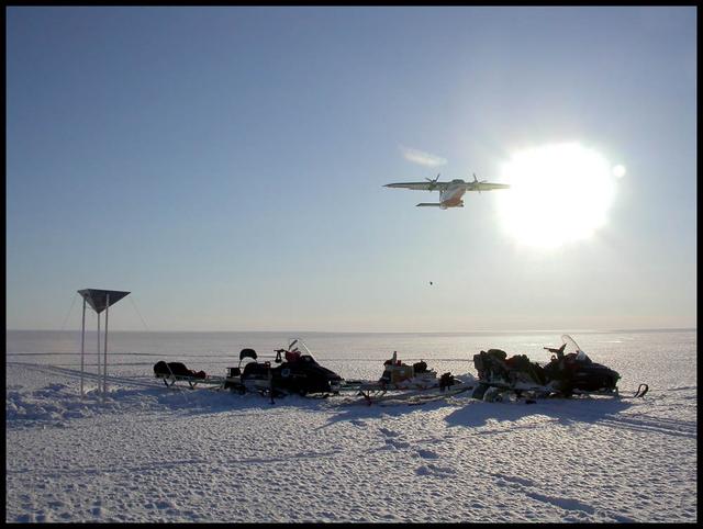
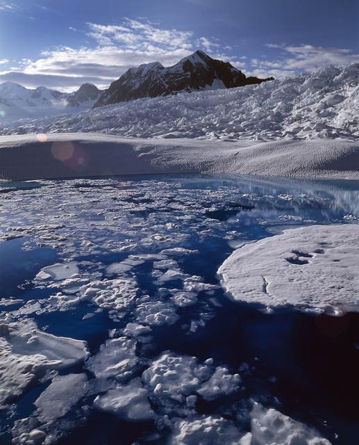
An airplane drops essential support on the Austfonna Ice Cap in Svalbard (Norwegian Arctic). The triangular structure is a corner reflector used as ground reference for airborne radar surveys. To learn about the contributions of glaciers to sea level rise, visit: <a href="http://www.nasa.gov/topics/earth/features/glacier-sea-rise.html" rel="nofollow">www.nasa.gov/topics/earth/features/glacier-sea-rise.html</a> Credit: Andrea Taurisano, Norwegian Polar Institute <b><a href="http://www.nasa.gov/audience/formedia/features/MP_Photo_Guidelines.html" rel="nofollow">NASA image use policy.</a></b> <b><a href="http://www.nasa.gov/centers/goddard/home/index.html" rel="nofollow">NASA Goddard Space Flight Center</a></b> enables NASA’s mission through four scientific endeavors: Earth Science, Heliophysics, Solar System Exploration, and Astrophysics. Goddard plays a leading role in NASA’s accomplishments by contributing compelling scientific knowledge to advance the Agency’s mission. <b>Follow us on <a href="http://twitter.com/NASA_GoddardPix" rel="nofollow">Twitter</a></b> <b>Like us on <a href="http://www.facebook.com/pages/Greenbelt-MD/NASA-Goddard/395013845897?ref=tsd" rel="nofollow">Facebook</a></b> <b>Find us on <a href="http://instagram.com/nasagoddard?vm=grid" rel="nofollow">Instagram</a></b>
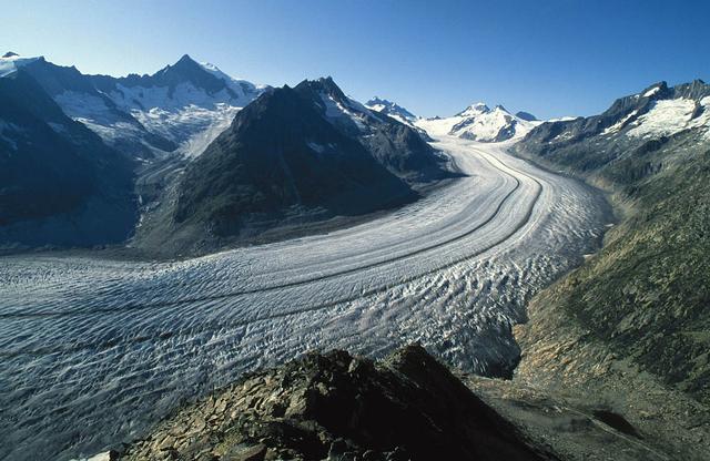
The Aletsch Glacier in Switzerland is the largest valley glacier in the Alps. Its volume loss since the middle of the 19th century is well-visible from the trimlines to the right of the image. To learn about the contributions of glaciers to sea level rise, visit: <a href="http://www.nasa.gov/topics/earth/features/glacier-sea-rise.html" rel="nofollow">www.nasa.gov/topics/earth/features/glacier-sea-rise.html</a> Credit: Frank Paul, University of Zurich <b><a href="http://www.nasa.gov/audience/formedia/features/MP_Photo_Guidelines.html" rel="nofollow">NASA image use policy.</a></b> <b><a href="http://www.nasa.gov/centers/goddard/home/index.html" rel="nofollow">NASA Goddard Space Flight Center</a></b> enables NASA’s mission through four scientific endeavors: Earth Science, Heliophysics, Solar System Exploration, and Astrophysics. Goddard plays a leading role in NASA’s accomplishments by contributing compelling scientific knowledge to advance the Agency’s mission. <b>Follow us on <a href="http://twitter.com/NASA_GoddardPix" rel="nofollow">Twitter</a></b> <b>Like us on <a href="http://www.facebook.com/pages/Greenbelt-MD/NASA-Goddard/395013845897?ref=tsd" rel="nofollow">Facebook</a></b> <b>Find us on <a href="http://instagram.com/nasagoddard?vm=grid" rel="nofollow">Instagram</a></b>
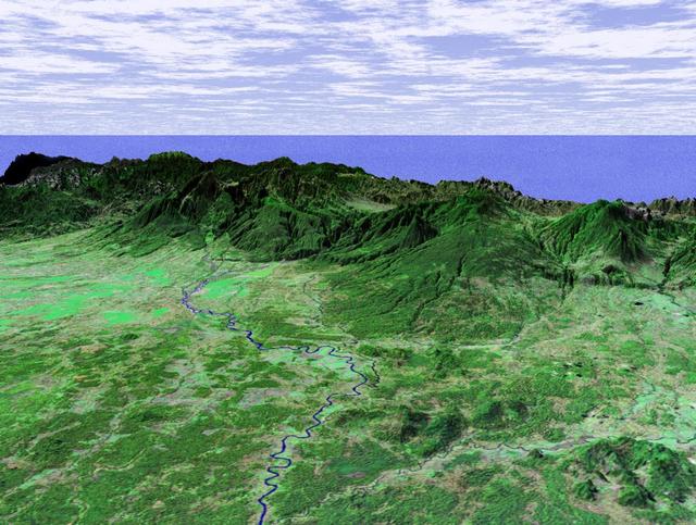
Small valley glacier exiting the Devon Island Ice Cap in Canada. To learn about the contributions of glaciers to sea level rise, visit: <a href="http://www.nasa.gov/topics/earth/features/glacier-sea-rise.html" rel="nofollow">www.nasa.gov/topics/earth/features/glacier-sea-rise.html</a> Credit: Alex Gardner, Clark University <b><a href="http://www.nasa.gov/audience/formedia/features/MP_Photo_Guidelines.html" rel="nofollow">NASA image use policy.</a></b> <b><a href="http://www.nasa.gov/centers/goddard/home/index.html" rel="nofollow">NASA Goddard Space Flight Center</a></b> enables NASA’s mission through four scientific endeavors: Earth Science, Heliophysics, Solar System Exploration, and Astrophysics. Goddard plays a leading role in NASA’s accomplishments by contributing compelling scientific knowledge to advance the Agency’s mission. <b>Follow us on <a href="http://twitter.com/NASA_GoddardPix" rel="nofollow">Twitter</a></b> <b>Like us on <a href="http://www.facebook.com/pages/Greenbelt-MD/NASA-Goddard/395013845897?ref=tsd" rel="nofollow">Facebook</a></b> <b>Find us on <a href="http://instagram.com/nasagoddard?vm=grid" rel="nofollow">Instagram</a></b>

Aerial view of the Sverdrup Glacier, a river of ice that flows from the interior of the Devon Island Ice Cap (Canada) into the ocean. To learn about the contributions of glaciers to sea level rise, visit: <a href="http://www.nasa.gov/topics/earth/features/glacier-sea-rise.html" rel="nofollow">www.nasa.gov/topics/earth/features/glacier-sea-rise.html</a> Credit: Alex Gardner, Clark University <b><a href="http://www.nasa.gov/audience/formedia/features/MP_Photo_Guidelines.html" rel="nofollow">NASA image use policy.</a></b> <b><a href="http://www.nasa.gov/centers/goddard/home/index.html" rel="nofollow">NASA Goddard Space Flight Center</a></b> enables NASA’s mission through four scientific endeavors: Earth Science, Heliophysics, Solar System Exploration, and Astrophysics. Goddard plays a leading role in NASA’s accomplishments by contributing compelling scientific knowledge to advance the Agency’s mission. <b>Follow us on <a href="http://twitter.com/NASA_GoddardPix" rel="nofollow">Twitter</a></b> <b>Like us on <a href="http://www.facebook.com/pages/Greenbelt-MD/NASA-Goddard/395013845897?ref=tsd" rel="nofollow">Facebook</a></b> <b>Find us on <a href="http://instagram.com/nasagoddard?vm=grid" rel="nofollow">Instagram</a></b>
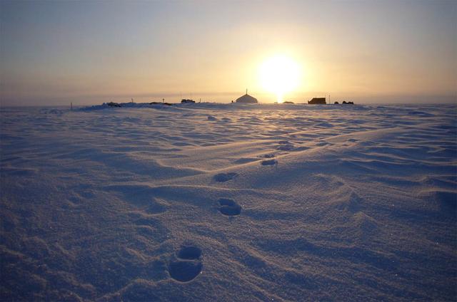
Summit camp on top of the Austfonna Ice Cap in Svalbard (Norwegian Arctic). To learn about the contributions of glaciers to sea level rise, visit: <a href="http://www.nasa.gov/topics/earth/features/glacier-sea-rise.html" rel="nofollow">www.nasa.gov/topics/earth/features/glacier-sea-rise.html</a> Credit: Thorben Dunse, University of Oslo <b><a href="http://www.nasa.gov/audience/formedia/features/MP_Photo_Guidelines.html" rel="nofollow">NASA image use policy.</a></b> <b><a href="http://www.nasa.gov/centers/goddard/home/index.html" rel="nofollow">NASA Goddard Space Flight Center</a></b> enables NASA’s mission through four scientific endeavors: Earth Science, Heliophysics, Solar System Exploration, and Astrophysics. Goddard plays a leading role in NASA’s accomplishments by contributing compelling scientific knowledge to advance the Agency’s mission. <b>Follow us on <a href="http://twitter.com/NASA_GoddardPix" rel="nofollow">Twitter</a></b> <b>Like us on <a href="http://www.facebook.com/pages/Greenbelt-MD/NASA-Goddard/395013845897?ref=tsd" rel="nofollow">Facebook</a></b> <b>Find us on <a href="http://instagram.com/nasagoddard?vm=grid" rel="nofollow">Instagram</a></b>
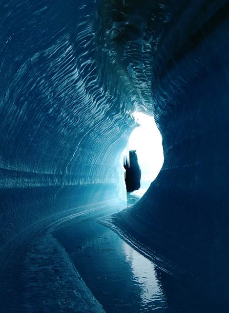
This ice cave in Belcher Glacier (Devon Island, Canada) was formed by melt water flowing within the glacier ice. To learn about the contributions of glaciers to sea level rise, visit: <a href="http://www.nasa.gov/topics/earth/features/glacier-sea-rise.html" rel="nofollow">www.nasa.gov/topics/earth/features/glacier-sea-rise.html</a> Credit: Angus Duncan, University of Saskatchewan <b><a href="http://www.nasa.gov/audience/formedia/features/MP_Photo_Guidelines.html" rel="nofollow">NASA image use policy.</a></b> <b><a href="http://www.nasa.gov/centers/goddard/home/index.html" rel="nofollow">NASA Goddard Space Flight Center</a></b> enables NASA’s mission through four scientific endeavors: Earth Science, Heliophysics, Solar System Exploration, and Astrophysics. Goddard plays a leading role in NASA’s accomplishments by contributing compelling scientific knowledge to advance the Agency’s mission. <b>Follow us on <a href="http://twitter.com/NASA_GoddardPix" rel="nofollow">Twitter</a></b> <b>Like us on <a href="http://www.facebook.com/pages/Greenbelt-MD/NASA-Goddard/395013845897?ref=tsd" rel="nofollow">Facebook</a></b> <b>Find us on <a href="http://instagram.com/nasagoddard?vm=grid" rel="nofollow">Instagram</a></b>
Calving front of the Perito Moreno Glacier (Argentina). Contrary to the majority of the glaciers from the southern Patagonian ice field, the Perito Moreno Glacier is currently stable. It is also one of the most visited glaciers in the world. To learn about the contributions of glaciers to sea level rise, visit: <a href="http://www.nasa.gov/topics/earth/features/glacier-sea-rise.html" rel="nofollow">www.nasa.gov/topics/earth/features/glacier-sea-rise.html</a> Credit: Etienne Berthier, Université de Toulouse <b><a href="http://www.nasa.gov/audience/formedia/features/MP_Photo_Guidelines.html" rel="nofollow">NASA image use policy.</a></b> <b><a href="http://www.nasa.gov/centers/goddard/home/index.html" rel="nofollow">NASA Goddard Space Flight Center</a></b> enables NASA’s mission through four scientific endeavors: Earth Science, Heliophysics, Solar System Exploration, and Astrophysics. Goddard plays a leading role in NASA’s accomplishments by contributing compelling scientific knowledge to advance the Agency’s mission. <b>Follow us on <a href="http://twitter.com/NASA_GoddardPix" rel="nofollow">Twitter</a></b> <b>Like us on <a href="http://www.facebook.com/pages/Greenbelt-MD/NASA-Goddard/395013845897?ref=tsd" rel="nofollow">Facebook</a></b> <b>Find us on <a href="http://instagram.com/nasagoddard?vm=grid" rel="nofollow">Instagram</a></b>
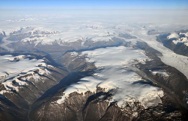
Peripheral glaciers and ice caps (isolated from the main ice sheet, which is seen in the upper right section of the image) in eastern Greenland. To learn about the contributions of glaciers to sea level rise, visit: <a href="http://www.nasa.gov/topics/earth/features/glacier-sea-rise.html" rel="nofollow">www.nasa.gov/topics/earth/features/glacier-sea-rise.html</a> Credit: Frank Paul, University of Zurich <b><a href="http://www.nasa.gov/audience/formedia/features/MP_Photo_Guidelines.html" rel="nofollow">NASA image use policy.</a></b> <b><a href="http://www.nasa.gov/centers/goddard/home/index.html" rel="nofollow">NASA Goddard Space Flight Center</a></b> enables NASA’s mission through four scientific endeavors: Earth Science, Heliophysics, Solar System Exploration, and Astrophysics. Goddard plays a leading role in NASA’s accomplishments by contributing compelling scientific knowledge to advance the Agency’s mission. <b>Follow us on <a href="http://twitter.com/NASA_GoddardPix" rel="nofollow">Twitter</a></b> <b>Like us on <a href="http://www.facebook.com/pages/Greenbelt-MD/NASA-Goddard/395013845897?ref=tsd" rel="nofollow">Facebook</a></b> <b>Find us on <a href="http://instagram.com/nasagoddard?vm=grid" rel="nofollow">Instagram</a></b>
Melt water ponded at surface in the accumulation zone of Columbia Glacier, Alaska, in July 2008. To learn about the contributions of glaciers to sea level rise, visit: <a href="http://www.nasa.gov/topics/earth/features/glacier-sea-rise.html" rel="nofollow">www.nasa.gov/topics/earth/features/glacier-sea-rise.html</a> Credit: W. Tad Pfeffer, University of Colorado at Boulder <b><a href="http://www.nasa.gov/audience/formedia/features/MP_Photo_Guidelines.html" rel="nofollow">NASA image use policy.</a></b> <b><a href="http://www.nasa.gov/centers/goddard/home/index.html" rel="nofollow">NASA Goddard Space Flight Center</a></b> enables NASA’s mission through four scientific endeavors: Earth Science, Heliophysics, Solar System Exploration, and Astrophysics. Goddard plays a leading role in NASA’s accomplishments by contributing compelling scientific knowledge to advance the Agency’s mission. <b>Follow us on <a href="http://twitter.com/NASA_GoddardPix" rel="nofollow">Twitter</a></b> <b>Like us on <a href="http://www.facebook.com/pages/Greenbelt-MD/NASA-Goddard/395013845897?ref=tsd" rel="nofollow">Facebook</a></b> <b>Find us on <a href="http://instagram.com/nasagoddard?vm=grid" rel="nofollow">Instagram</a></b>

This poster highlights NASA JPL missions that provide important inputs to research in sea level rise and variability -- key measures of ocean circulation and global climate change.
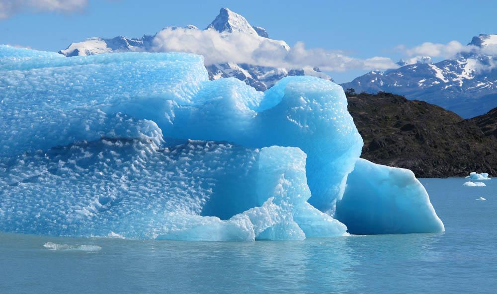
Calving front of the Upsala Glacier (Argentina). This glacier has been thinning and retreating at a rapid rate during the last decades – from 2006 to 2010, it receded 43.7 yards (40 meters) per year. During summer 2012, large calving events prevented boat access to the glacier. To learn about the contributions of glaciers to sea level rise, visit: <a href="http://www.nasa.gov/topics/earth/features/glacier-sea-rise.html" rel="nofollow">www.nasa.gov/topics/earth/features/glacier-sea-rise.html</a> Credit: Etienne Berthier, Université de Toulouse <b><a href="http://www.nasa.gov/audience/formedia/features/MP_Photo_Guidelines.html" rel="nofollow">NASA image use policy.</a></b> <b><a href="http://www.nasa.gov/centers/goddard/home/index.html" rel="nofollow">NASA Goddard Space Flight Center</a></b> enables NASA’s mission through four scientific endeavors: Earth Science, Heliophysics, Solar System Exploration, and Astrophysics. Goddard plays a leading role in NASA’s accomplishments by contributing compelling scientific knowledge to advance the Agency’s mission. <b>Follow us on <a href="http://twitter.com/NASA_GoddardPix" rel="nofollow">Twitter</a></b> <b>Like us on <a href="http://www.facebook.com/pages/Greenbelt-MD/NASA-Goddard/395013845897?ref=tsd" rel="nofollow">Facebook</a></b> <b>Find us on <a href="http://instagram.com/nasagoddard?vm=grid" rel="nofollow">Instagram</a></b>
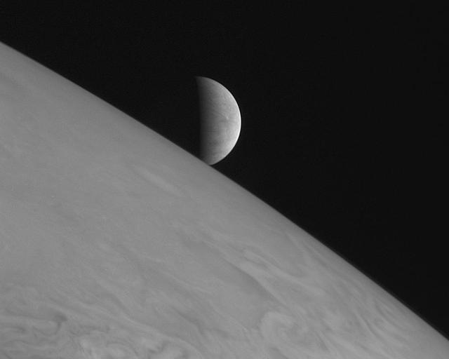
New Horizons took this image of the icy moon Europa rising above Jupiter cloud tops with its Long Range Reconnaissance Imager LORRI at 11:48 Universal Time on February 28, 2007, six hours after the spacecraft closest approach to Jupiter.
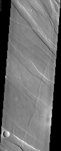
This image of Tharsis Rise from NASA Mars Odyssey shows a series of linear features called graben, which are associated with crustal extension resulting in up and down blocks of crust that run perpendicular to the direction of the extension.

Jupiter's moon Io rises just off the horizon of the gas giant planet in this image from NASA's Juno spacecraft. Slightly larger than Earth's moon, Io is the most volcanically active world in the solar system. This color-enhanced image was taken at 2:26 p.m. PDT (5:56 p.m. EDT) on Oct. 29, 2018 as the spacecraft performed its 16th close flyby of Jupiter. At the time, Juno was about 11,400 miles (18,400 kilometers) from the planet's cloud tops, at approximately 32 degrees south latitude. https://photojournal.jpl.nasa.gov/catalog/PIA22693 . - Enhanced image by Gerald Eichstädt and Justin Cowart based on images provided courtesy of NASA/JPL-Caltech/SwRI/MSSS

Over the past 30 years, global average sea level has risen a total of 3.6 inches (9.1 centimeters), as indicated in this graphic, which is based on sea level measurements (in blue) from five successive satellites starting with the U.S.-French TOPEX/Poseidon mission in 1993. The solid red line shows the trajectory of sea level rise from 1993 to 2022, while the dotted red line shows the increase sea level into the future. Researchers can take the solid red line and calculate the rate of sea level rise, which was 0.08 inches (0.20 centimeters) per year in 1993 and doubled to 0.17 inches (0.44 centimeters) per year by 2022. The dotted red line shows that by 2040, sea levels may rise by an additional 3.66 inches (9.3 cm) above 2022 levels. The trajectory shown in the solid and dotted red line is based on work by the NASA Sea Level Change Team and the Ocean Surface Topography Science Team. https://photojournal.jpl.nasa.gov/catalog/PIA25775

This graph shows the rise in global mean sea level from 1993 to 2023 based on data from a series of five international satellites. The solid red line indicates the trajectory of this increase, which has more than doubled over the three decades. The dotted red line projects future sea level rise. The relatively large jump in sea level from 2022 to 2023, a rise of about 0.3 inches (0.76 centimeters), is due mostly to a warming climate and the development of a strong El Niño. The 2022-2023 rise is equivalent to draining a quarter of Lake Superior into the ocean over the course of a year. This NASA-led analysis is based on a sea level data set featuring more than 30 years of satellite observations, starting with the U.S.-French TOPEX/Poseidon mission, which launched in 1992. The Sentinel-6 Michael Freilich mission, which launched in November 2020, is the latest in the series of satellites that have contributed to this sea level record. https://photojournal.jpl.nasa.gov/catalog/PIA26183

The full Moon, also known in January as the Wolf Moon, rises above the Lincoln Memorial and the Memorial Bridge, Monday, Jan. 13, 2025, as seen from Arlington, Virginia. Photo Credit: (NASA/Bill Ingalls)
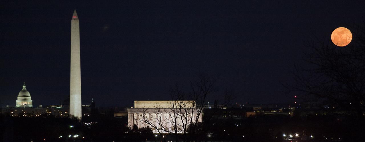
The full moon is seen as it rises near the National Mall, Saturday, March 19, 2011, in Washington. The full moon tonight is called a "Super Moon" since it is at its closest to Earth. Photo Credit: (NASA/Paul E. Alers)
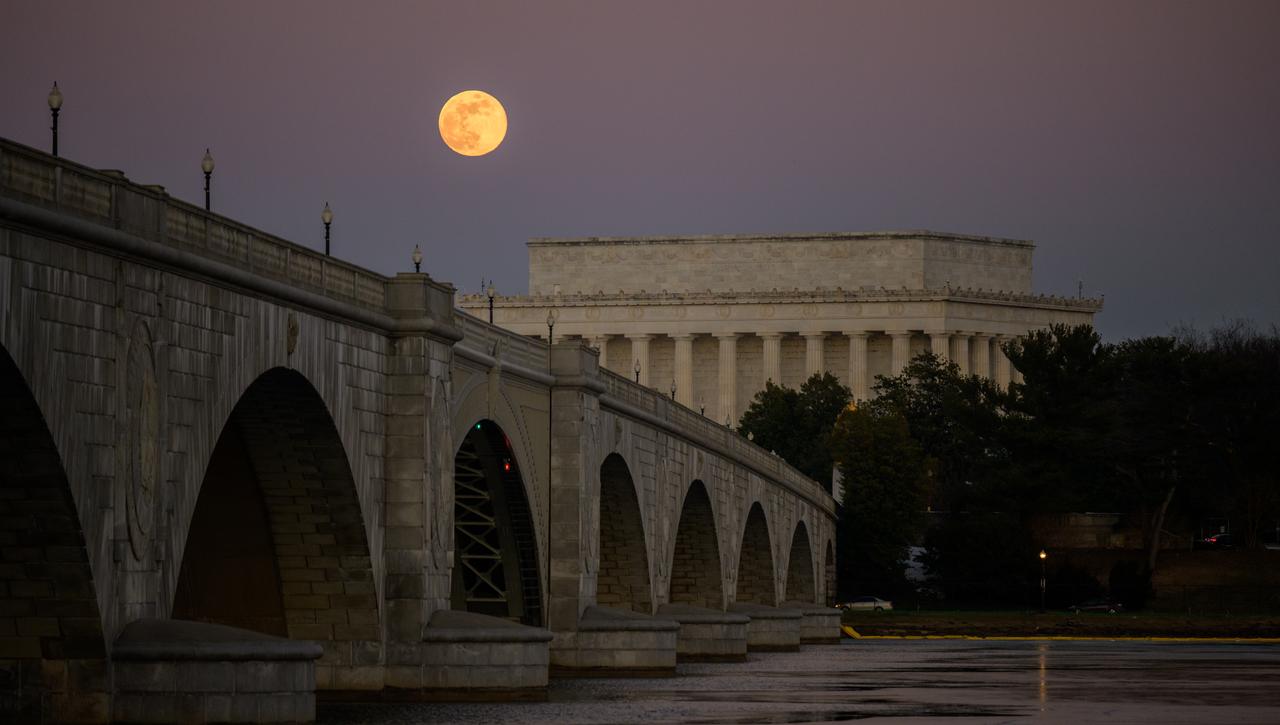
The full Moon, also known in January as the Wolf Moon, rises above the Lincoln Memorial and the Memorial Bridge, Monday, Jan. 13, 2025, as seen from Arlington, Virginia. Photo Credit: (NASA/Bill Ingalls)
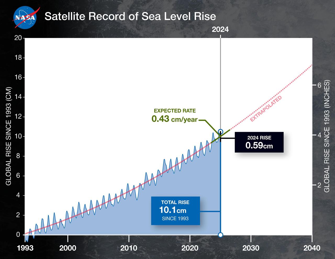
This graph shows the rise in global mean sea level from 1993 to 2024 based on data from a series of five international satellites. The solid red line indicates the trajectory of this increase, which has more than doubled over the three decades. The dotted red line projects future sea level rise. Global sea level rose faster than expected in 2024 due mostly to ocean water expanding as it warms, or thermal expansion. According to a NASA-led analysis, last year's rate of rise was 0.23 inches (0.59 centimeters) per year, compared to the expected rate of 0.17 inches (0.43 centimeters) per year. In recent years, about two-thirds of sea level rise was due to the addition of water from land into the ocean by melting ice sheets and glaciers. About a third came from thermal expansion of seawater. But in 2024, those contributions flipped, with two-thirds of sea level rise coming from thermal expansion. This NASA-led analysis is based on a sea level dataset featuring more than 30 years of satellite observations, starting with the U.S.-French TOPEX/Poseidon mission, which launched in 1992. The Sentinel-6 Michael Freilich mission, which launched in November 2020, is the latest in the series of satellites that have contributed to this sea level record. https://photojournal.jpl.nasa.gov/catalog/PIA26189
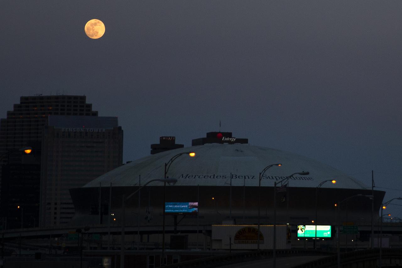
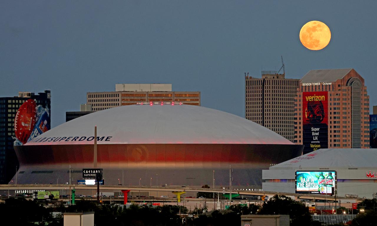
The nearly full moon rises over the Superdome and the city of New Orleans on Tuesday evening, May 25, 2021. Image credit: NASA/Michael DeMocker

iss071e206291 (June 20, 2024) -- A waxing gibbous moon rises over the Indian Ocean as the International Space Station orbited 266 miles above.
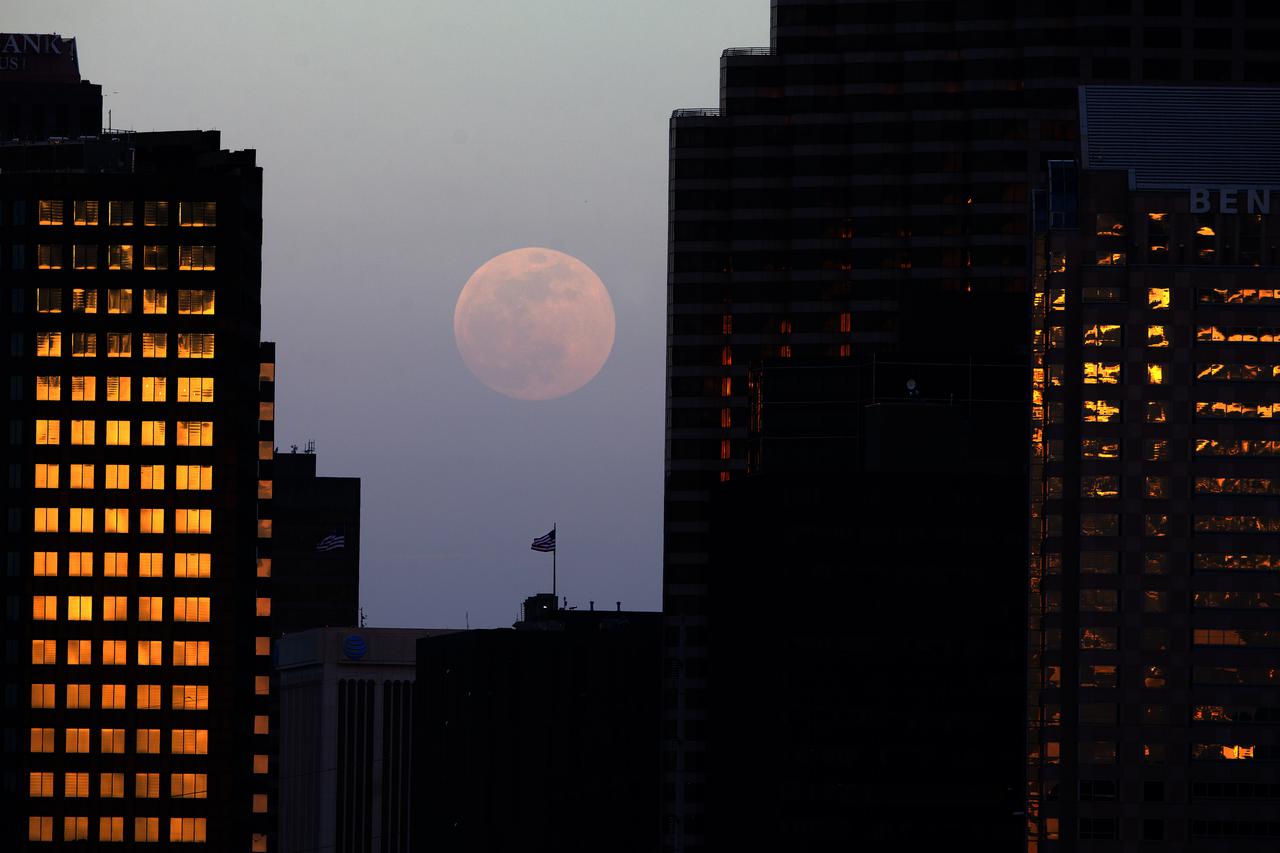
The nearly full moon rises over the city of New Orleans on Tuesday evening, May 25, 2021. Image credit: NASA/Michael DeMocker
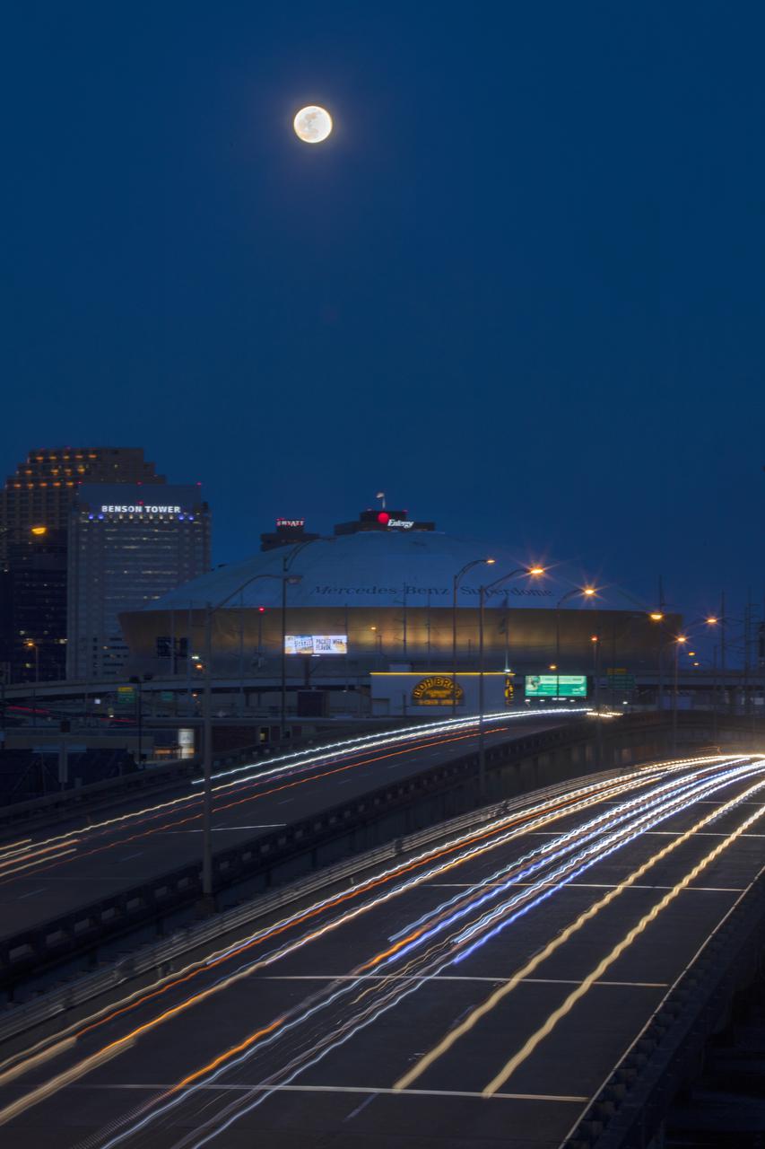
The nearly full moon rises over the city of New Orleans on Tuesday evening, May 25, 2021. Image credit: NASA/Michael DeMocker
The nearly full moon rises over the city of New Orleans on Tuesday evening, May 25, 2021. Image credit: NASA/Michael DeMocker

iss071e406275 (July 27, 2024) -- The third quarter moon rises just above Earth's blue horizon as the International Space Station orbited 258 miles above the Red Sea.
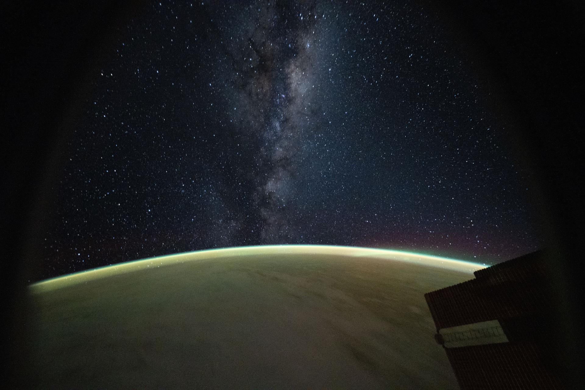
iss074e0521637 (April 13, 2026) --- This celestial image captured from a window on a SpaceX Dragon spacecraft docked to the International Space Station highlights the Milky Way rising above Earth's atmospheric glow. Credit: NASA/Chris Williams

NASA's Curiosity Mars rover used its Mast Camera, or Mastcam, to capture this view of Earth setting while Phobos, one of Mars' two moons, is rising. It's the first time an image of the two celestial bodies have been captured together from the surface of Mars. The image is a composite of five short exposures and 12 long exposures all taken on Sept. 5, 2024, the 4,295th Martian day, or sol, of Curiosity's mission. An inset in the image shows Phobos on the left and Earth on the right. From the rover's perspective, the inset area would be about half the width of a thumb held at arm's length. The image shows the sky over Texoli, a butte on lower Mount Sharp, a 3-mile-tall (5-kilometer-tall) mountain that Curiosity has been ascending since 2014. https://photojournal.jpl.nasa.gov/catalog/PIA26362
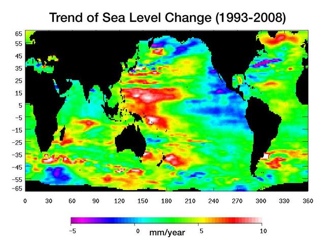
Warming water and melting land ice have raised global mean sea level 4.5 centimeters 1.7 inches from 1993 to 2008. But the rise is by no means uniform.
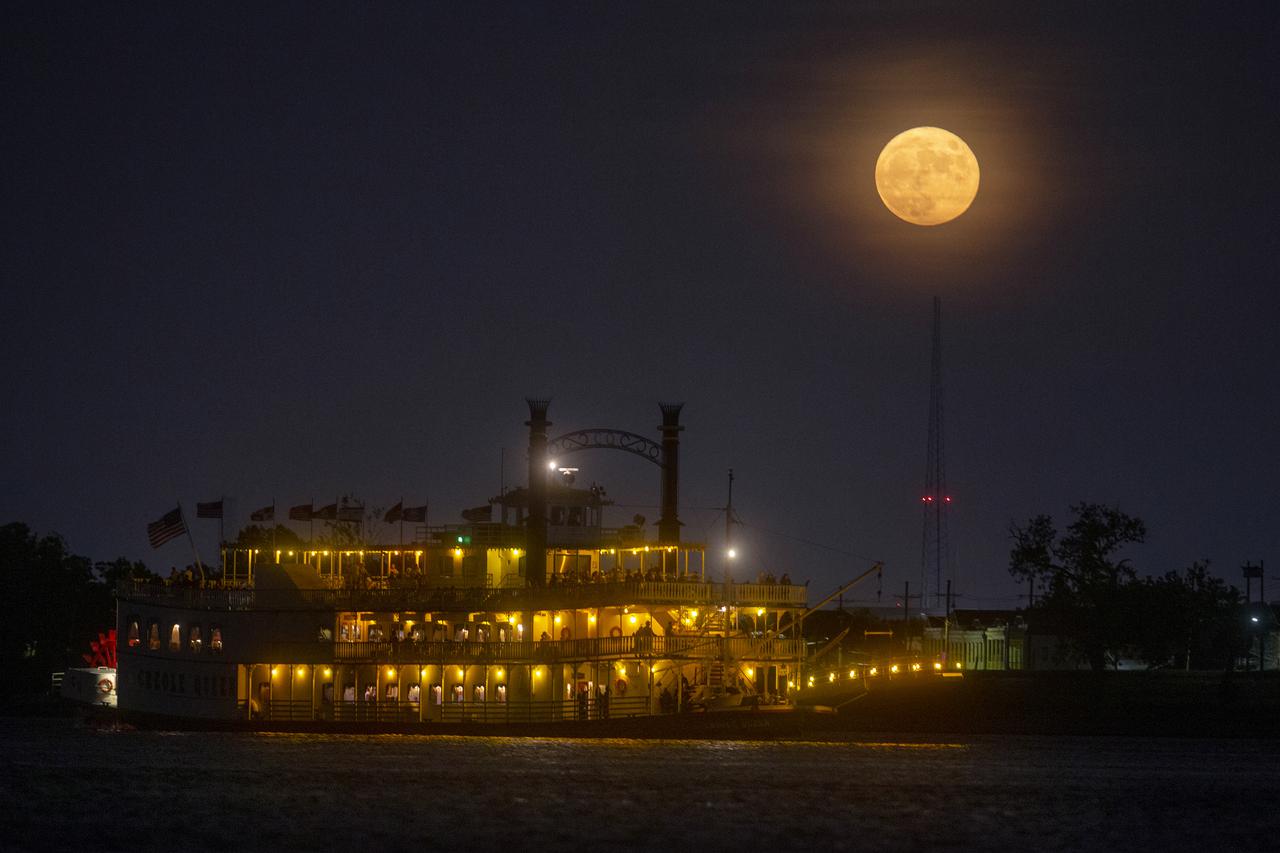
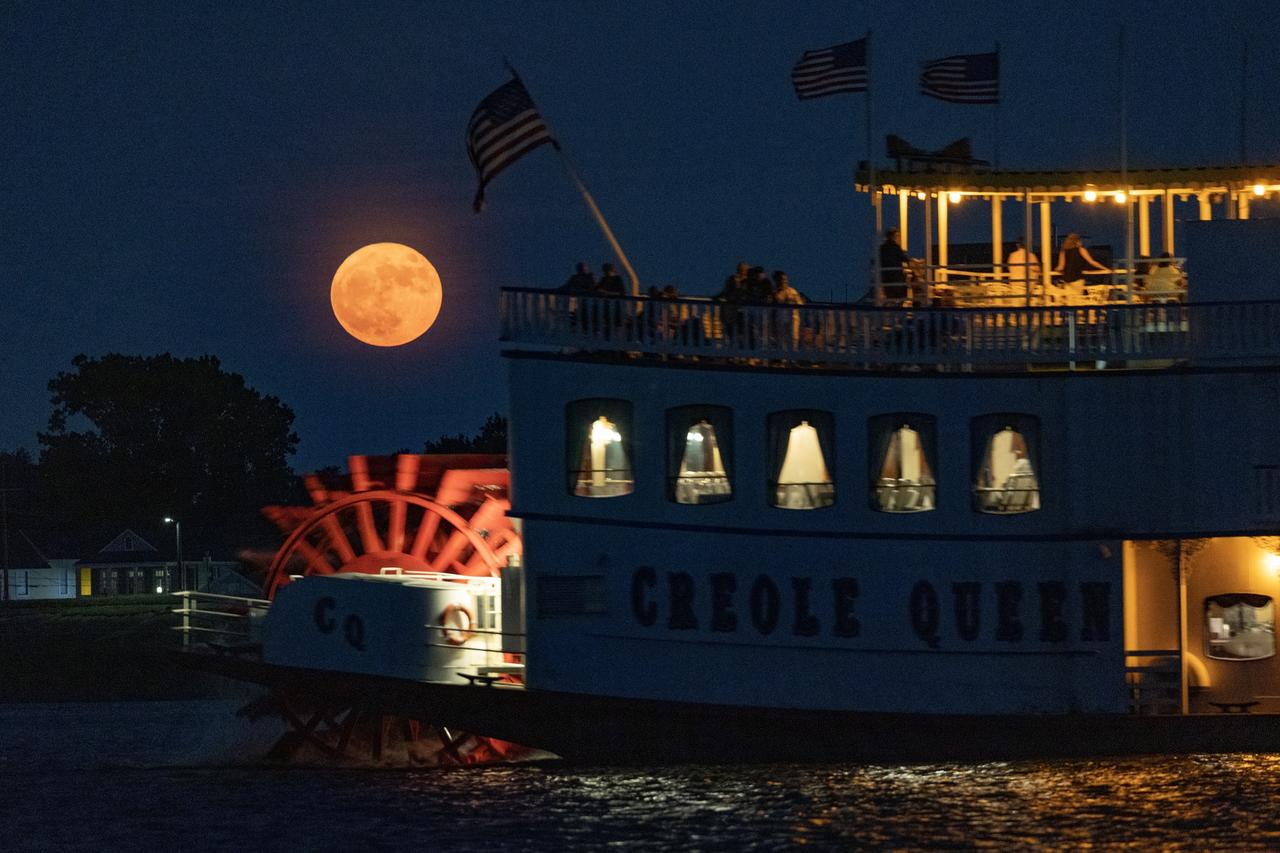
A paddlewheeler makes its way up the Mississippi River as the moon rises over New Orleans on Sunday evening, August 22, 2021. The August Sturgeon Moon, which was also a rare Blue Moon, was full at 7:02 A.M. local time Sunday but the nearly full moon still put on a show when it rose over New Orleans later that evening. New Orleans is home to the NASA Michoud Assembly Facility where the core stage of the Space Launch System that will return people to the moon is being built. Image credit: NASA/Michael DeMocker
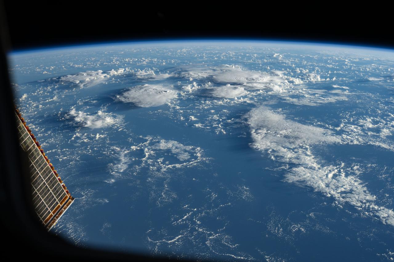
iss072e617674 (Feb. 1, 2025) --- Storm clouds rise above the South Pacific Ocean northwest of New Zealand in this photograph from the International Space Station as it orbited 264 miles above.

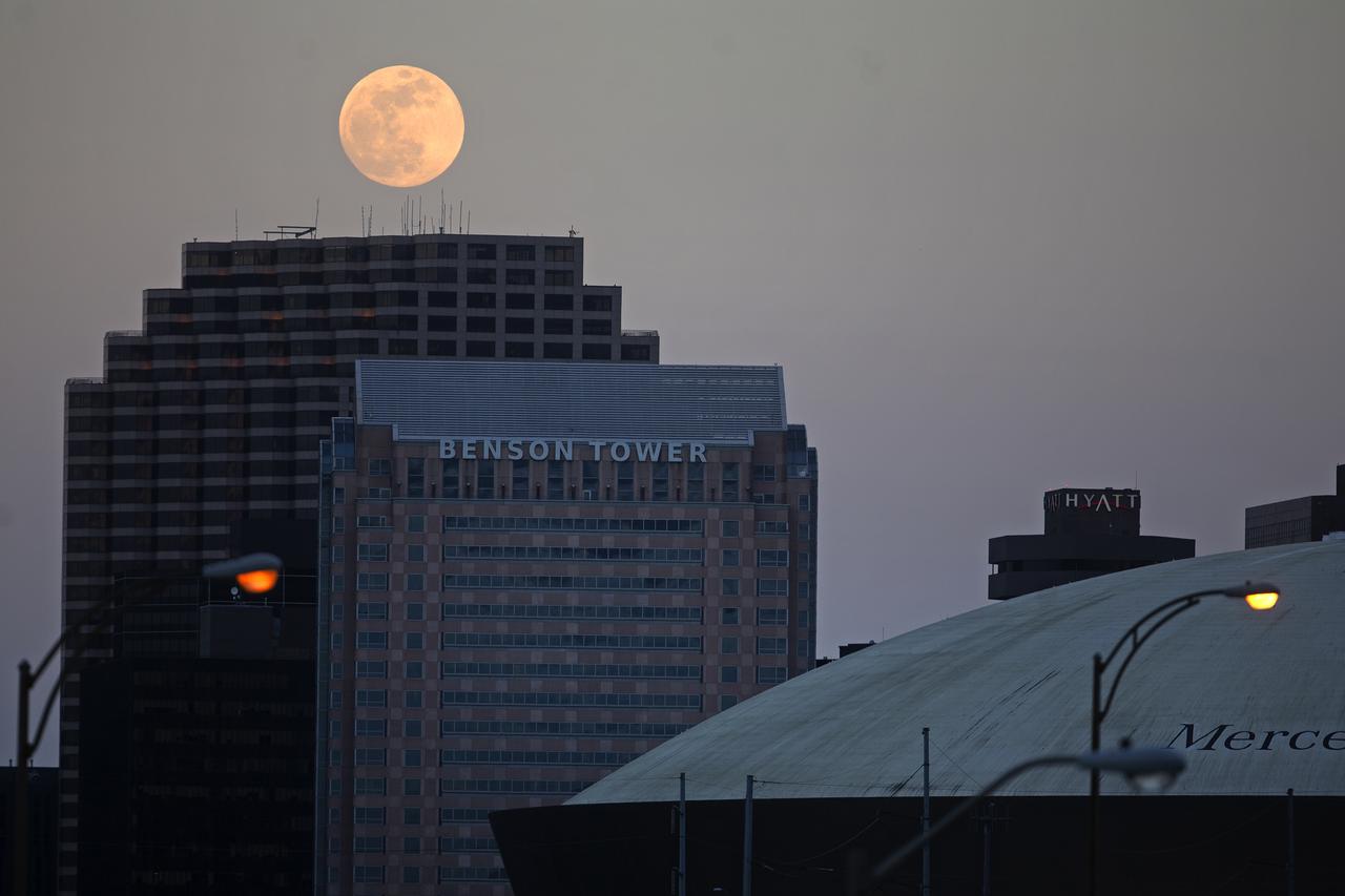
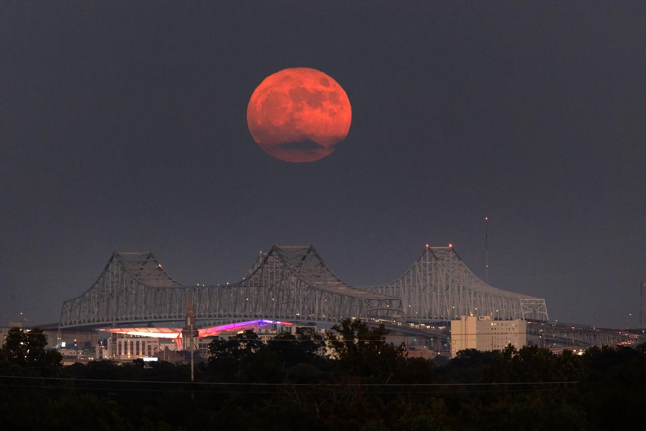
The full moon rises over the Superdome and the city of New Orleans, Louisiana on Monday evening, January 13, 2025. The Wolf Moon, also known as the Ice or Cold Moon, was full at 5:27 p.m. EST. New Orleans is home to NASA’s Michoud Assembly Facility where several pieces of hardware for the SLS (Space Launch system) are being built. Image credit: NASA/Michael DeMocker
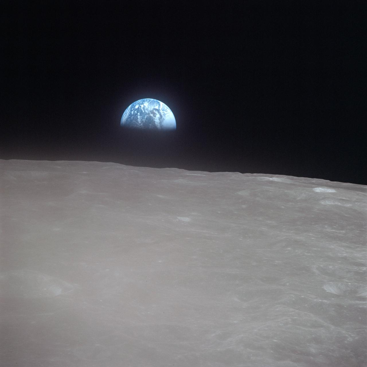
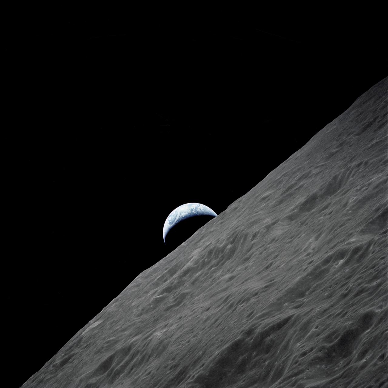
AS16-120-19187 (19 April 1972) --- Apollo 16 astronauts captured this Earth rise scene with a handheld Hasselblad camera during the second revolution of the moon. Identifiable craters seen on the moon include Saha, Wyld, and Saenger. Much of the terrain seen here is never visible from Earth, as the Command Module (CM) was just passing onto what is known as the dark side or far side of the moon. Crewmen aboard the CM at the time the photo was made were astronauts John W. Young, Thomas K. Mattingly II and Charles M. Duke Jr. Mattingly remained later with the CM in lunar orbit while Young and Duke descended in the lunar module (LM) to explore the surface of the moon.
iss073e0819960 (Oct. 3, 2025) --- The waxing gibbous Moon rises above Earth’s blue atmosphere in this photograph taken from the International Space Station as it orbited 263 miles above a cloudy Atlantic Ocean off the coast of Quebec, Canada.
AS10-27-3890 (18-26 May 1969) --- A view of Earth rising above the lunar horizon photographed from the Apollo 10 Lunar Module, looking west in the direction of travel. The Lunar Module at the time the picture was taken was located above the lunar farside highlands at approximately 105 degrees east longitude.
A supermoon rises over the Mississippi River and the Crescent City Aug. 1. The early August full Moon is the second largest in Earth’s skies for 2023. Later in August, a full Moon will appear in the skies for a second time. New Orleans is home to NASA’s Michoud Assembly Facility, where stages for NASA’s SLS (Space Launch System) rocket and structures for Orion spacecraft are produced for the Artemis missions.
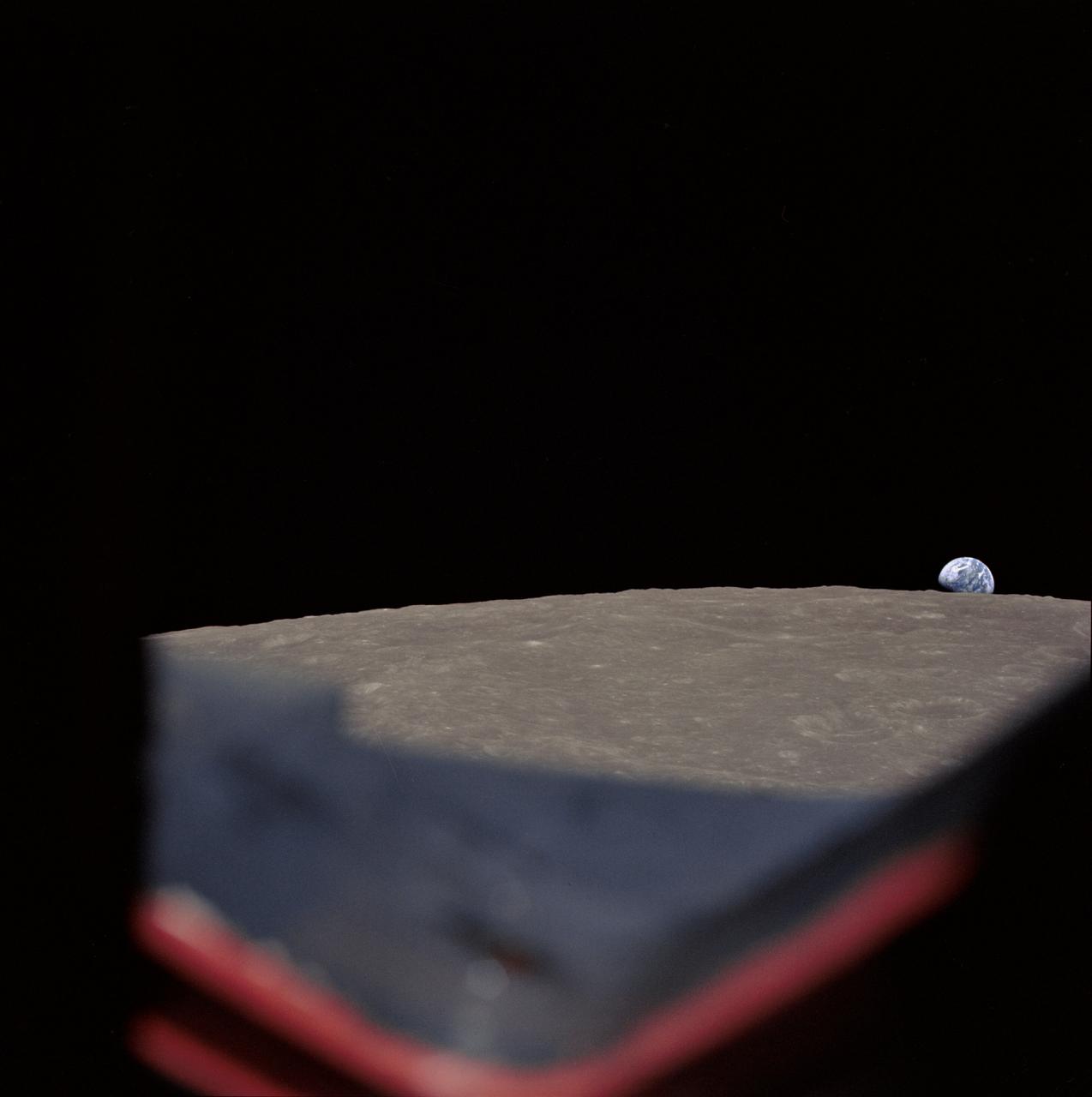
AS17-152-23274 (7-19 Dec. 1972) --- The crescent Earth rises above the lunar horizon in this spectacular photograph taken from the Apollo 17 spacecraft in lunar orbit during National Aeronautics and Space Administration's (NASA) final lunar landing mission in the Apollo program. While astronauts Eugene A. Cernan, commander, and Harrison H. Schmitt, lunar module pilot, descended in the Lunar Module (LM) "Challenger" to explore the Taurus-Littrow region of the moon, astronaut Ronald E. Evans, command module pilot, remained with the Command and Service Modules (CSM) "America" in lunar orbit.

art002e013365 (April 7, 2026) – The Artemis II crew – (clockwise from left) Mission Specialist Christina Koch, Mission Specialist Jeremy Hansen, Commander Reid Wiseman, and Pilot Victor Glover – pause for a group photo with their zero gravity indicator "Rise," inside the Orion spacecraft on their way home. Following a swing around the far side of the Moon on April 6, 2026, the crew exited the lunar sphere of influence (the point at which the Moon's gravity has a stronger pull on Orion than the Earth's) on April 7, and are headed back to Earth for a splashdown in the Pacific Ocean on April 10.
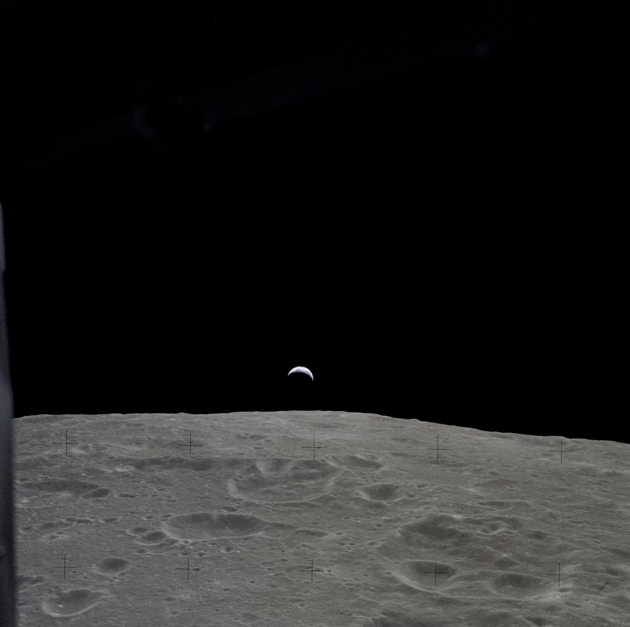
AS12-47-6891 (14-24 Nov. 1969) --- A partially illuminated Earth rises above the lunar horizon in this photograph taken from the Apollo 12 spacecraft in lunar orbit.

A supermoon rises over Huntsville, Alabama, home to NASA’s Marshall Space Flight Center, Aug. 19. Visible through Wednesday, Aug. 21, the full Moon is both a supermoon and a Blue Moon. Supermoons are the biggest and brightest full Moons of the year because the Moon is within 90% of its closest point to Earth. While not blue in color, the third full Moon in a season with four full Moons is called a “Blue Moon.” Huntsville is known as the “Rocket City” because of its proximity to NASA Marshall, which manages vital propulsion systems and hardware, launch vehicles, engineering technologies, and cutting-edge science for the agency.

A supermoon rises over Huntsville, Alabama, home to NASA’s Marshall Space Flight Center, Aug. 19. Visible through Wednesday, Aug. 21, the full Moon is both a supermoon and a Blue Moon. Supermoons are the biggest and brightest full Moons of the year because the Moon is within 90% of its closest point to Earth. While not blue in color, the third full Moon in a season with four full Moons is called a “Blue Moon.” Huntsville is known as the “Rocket City” because of its proximity to NASA Marshall, which manages vital propulsion systems and hardware, launch vehicles, engineering technologies, and cutting-edge science for the agency.
A Super Blue Moon rises above the Mississippi River and the Crescent City Connection Bridge in New Orleans, Aug. 30. The full moon is “super” because it’s slightly closer to Earth and “blue” because it’s the second full moon in a month. About 25% of all full moons are supermoons, but only 3% of full moons are blue moons. The next super blue moons will occur in a pair in January and March 2037. New Orleans is home to NASA’s Michoud Assembly Facility, where stages for NASA’s SLS (Space Launch System) rocket and structures for Orion spacecraft are produced for the Artemis missions.

A supermoon rises over Huntsville, Alabama, home to NASA’s Marshall Space Flight Center, Aug. 19. Visible through Wednesday, Aug. 21, the full Moon is both a supermoon and a Blue Moon. Supermoons are the biggest and brightest full Moons of the year because the Moon is within 90% of its closest point to Earth. While not blue in color, the third full Moon in a season with four full Moons is called a “Blue Moon.” Huntsville is known as the “Rocket City” because of its proximity to NASA Marshall, which manages vital propulsion systems and hardware, launch vehicles, engineering technologies, and cutting-edge science for the agency.
AS8-14-2392 (21-27 Dec. 1968) --- High-oblique view of the moon's surface showing Earth rising above the lunar horizon, looking west-southwest, as photographed from the Apollo 8 spacecraft as it orbited the moon. The center of the picture is located at about 105 degrees east longitude and 13 degrees south latitude. The lunar surface probably has less pronounced color than indicated by this print.
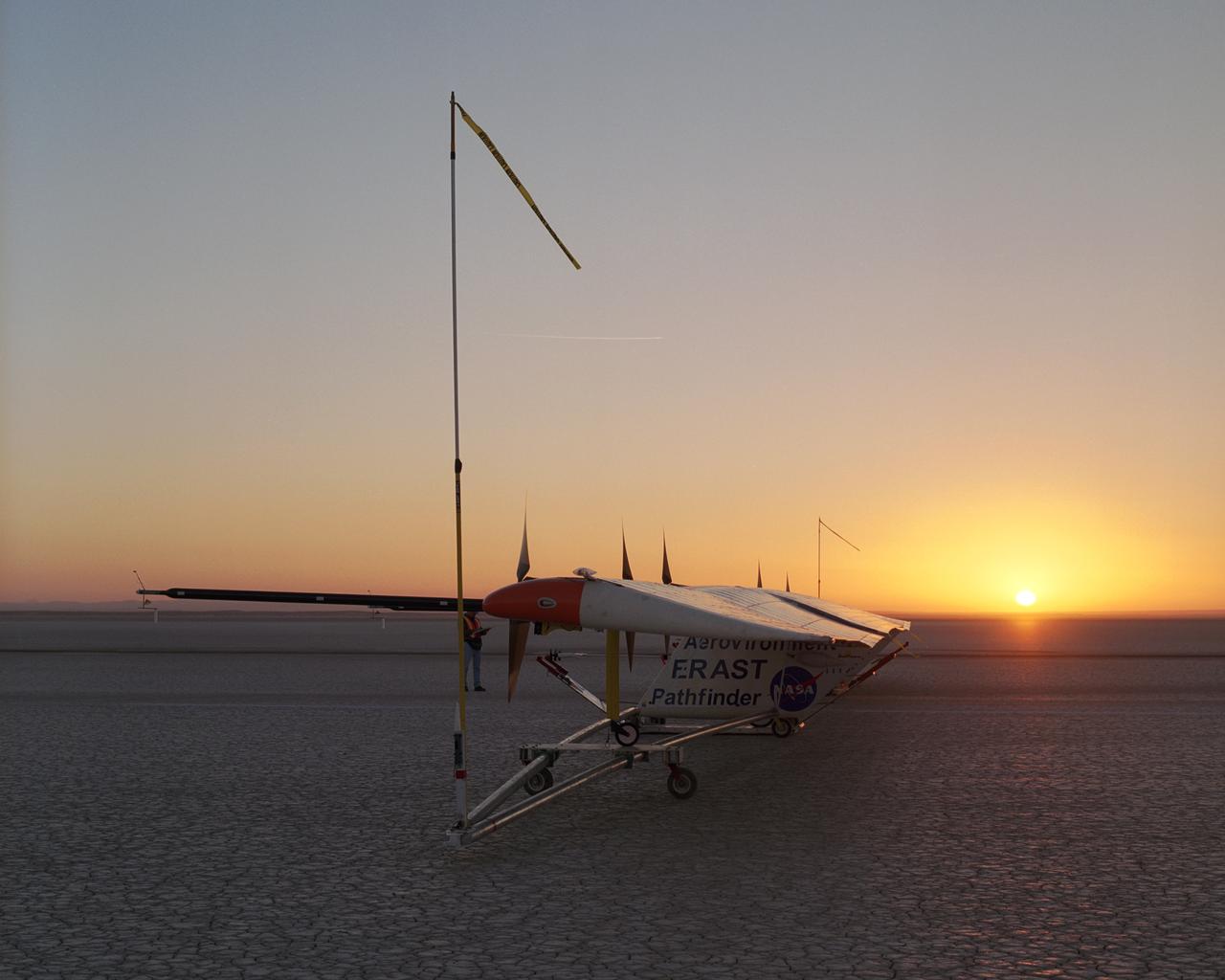
As the rising sun dawns over the parched bed of Rogers Dry Lake, AeroVironment's solar-electric Pathfinder-Plus awaits takeoff on its final research flight.
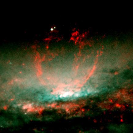
A lumpy bubble of hot gas rises from a cauldron of glowing matter in a distant galaxy, as seen by NASA Hubble Space Telescope.
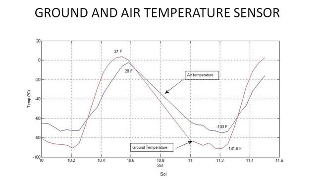
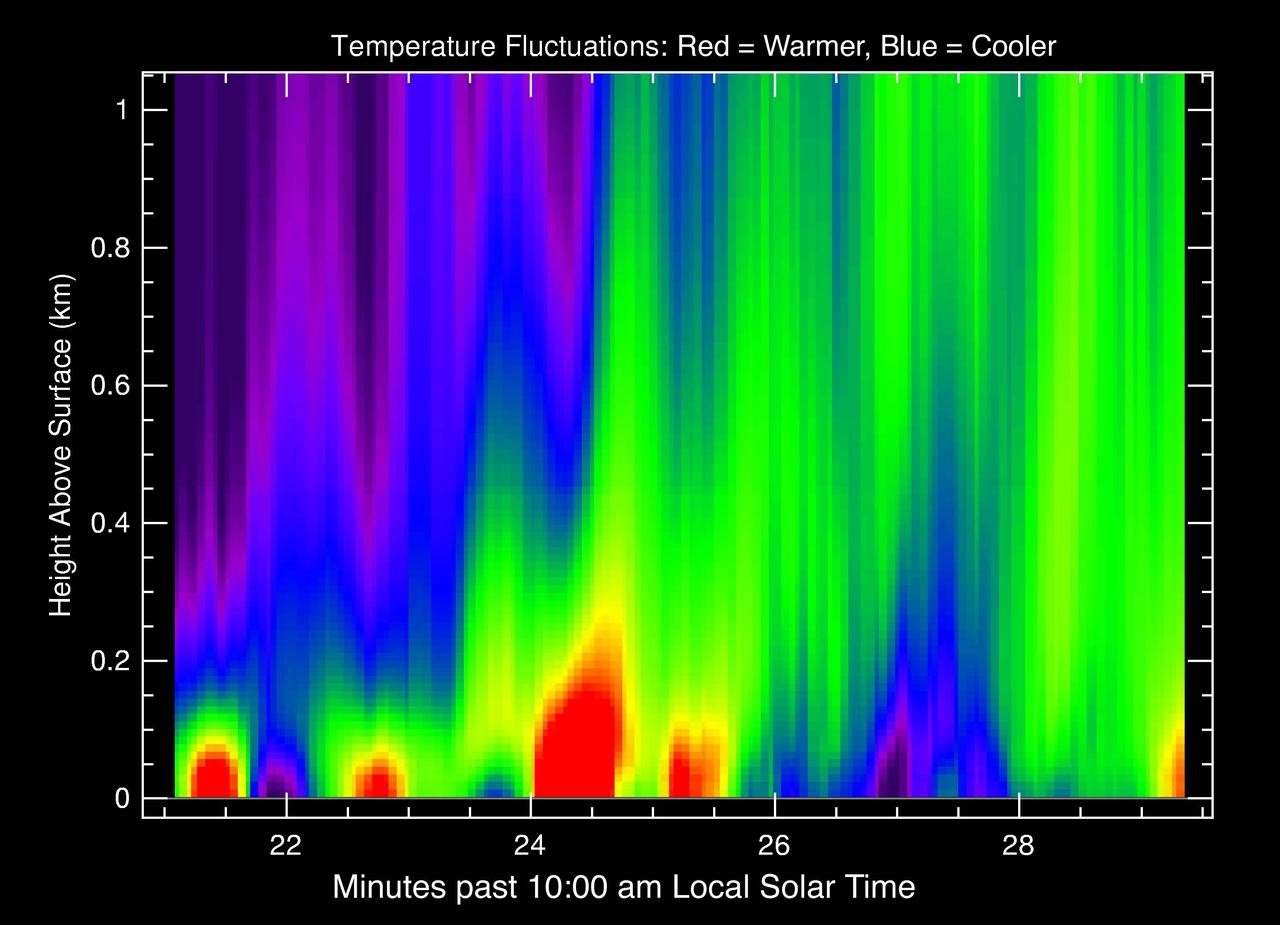
This graph shows the rise and fall of air and ground temperatures on Mars obtained by NASA Curiosity rover.
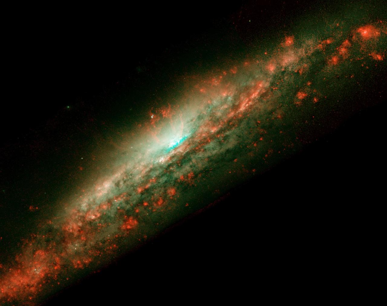
A lumpy bubble of hot gas rises from a cauldron of glowing matter in a distant galaxy, as seen by NASA Hubble Space Telescope.
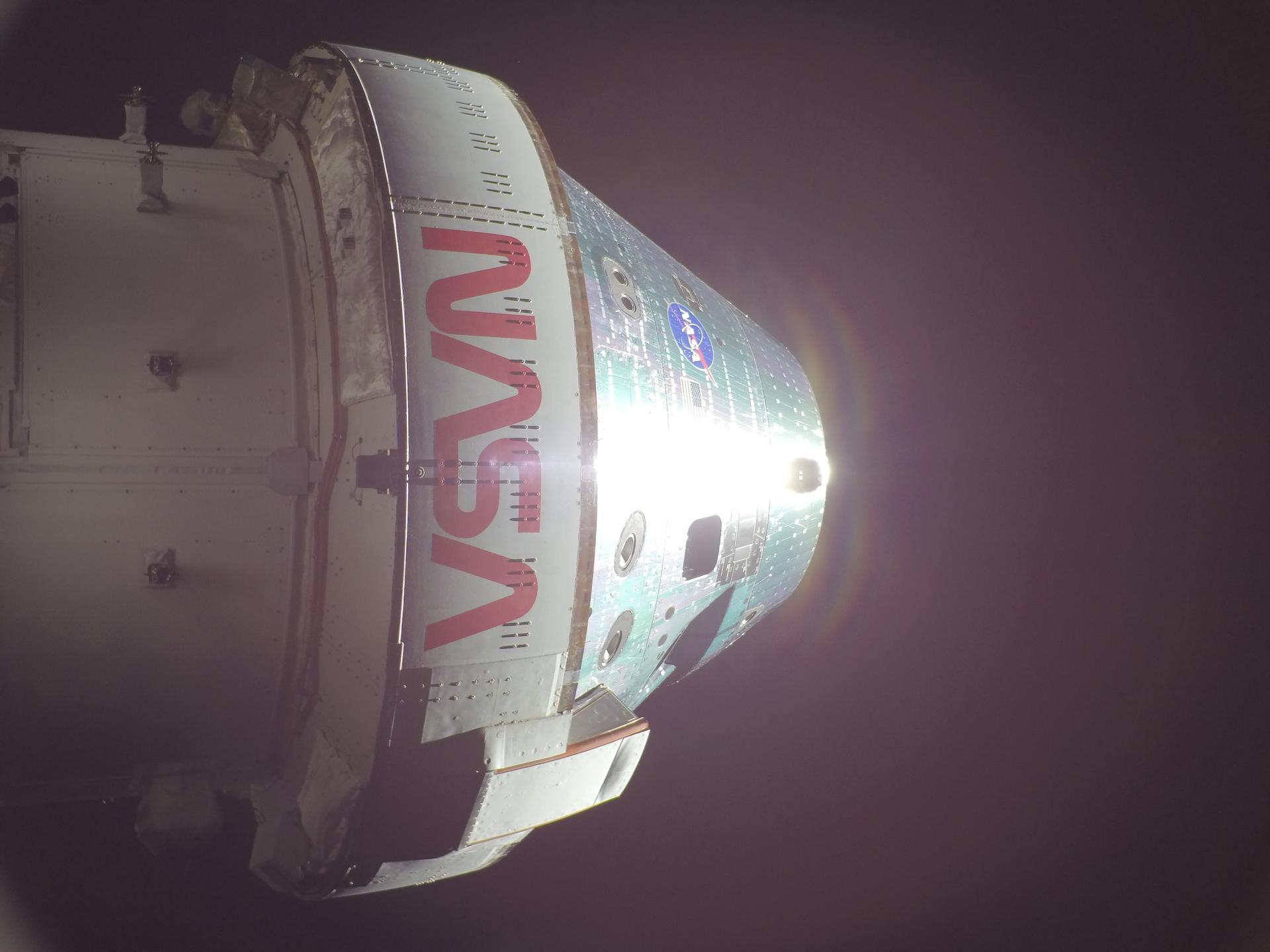
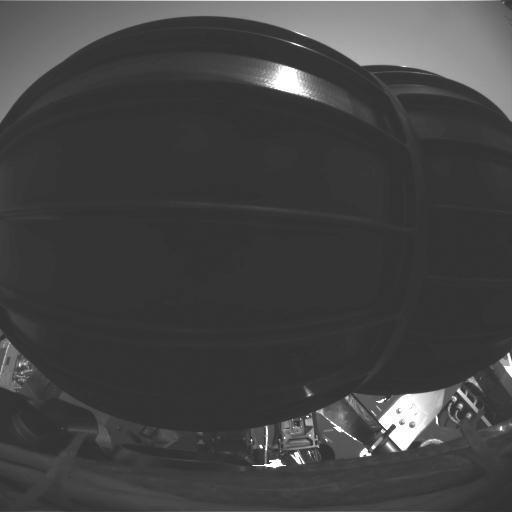
art002e012487 (April 7, 2026) - NASA’s Orion spacecraft is pictured here from one of the cameras mounted on its solar array wings. At the time this photo was taken at 8:33 a.m. ET, the Artemis II crew was in a sleep period ahead of beginning their seventh day into the mission.

NASA’s Artemis II commander Reid Wiseman, holds ‘Rise’ the zero gravity indicator, up for a photograph in Times Square, New York, after ringing the closing bell of the Nasdaq market session, with fellow crewmembers; CSA (Canadian Space Agency) astronaut Jeremy Hansen, mission specialist; and NASA astronauts Victor Glover, pilot; Christina Koch, mission specialist, Thursday, April 30, 2026. NASA’s Artemis II mission took Wiseman, Glover, Koch, and Hansen on a nearly 10-day journey around the Moon and back to Earth earlier in April 2026. Photo Credit: (NASA/Bill Ingalls)

NASA’s Artemis II commander Reid Wiseman, poses for a photograph, in Times Square, New York, while holding ‘Rise’ the zero gravity indicator, soon after ringing the closing bell of the Nasdaq market session, with fellow crewmembers; CSA (Canadian Space Agency) astronaut Jeremy Hansen, mission specialist; and NASA astronauts Victor Glover, pilot; Christina Koch, mission specialist, Thursday, April 30, 2026. NASA’s Artemis II mission took Wiseman, Glover, Koch, and Hansen on a nearly 10-day journey around the Moon and back to Earth earlier in April 2026. Photo Credit: (NASA/Bill Ingalls)
Dust devils form by rising and rotating warm air pockets. Air near the soil surface can become heated by contact with the warmer ground during the day. The warm air is less dense and rises through the cooler air above it. As additional air moves inward along the surface to replace the rising pocket, it begins to rotate driven by Coriolis forces, and forms a vortex of spinning air. When the incoming air rises into the column, its rotation picks up speed like a spinning ice skater bring their arms closer to their body. This faster moving air near the soil surface can cause sand grains to bounce and kick up dust which easily rises up into the growing vortex. In this way a dust devil is born. The study of dust devils is important because they indicate atmospheric conditions such prevailing wind directions and speed. They also periodically cleanse the surface of the dust that gradually settles from the atmosphere. This is something that can be extremely helpful to robotic missions like InSight and Curiosity to keep their solar panels from getting too dusty. https://photojournal.jpl.nasa.gov/catalog/PIA24465

“Rise,” the Artemis II zero-gravity indicator, is seen sitting on the dais as NASA astronauts Reid Wiseman, commander; Victor Glover, pilot; Christina Koch, mission specialist; and CSA (Canadian Space Agency) astronaut Jeremy Hansen, mission specialist; speak with congressional staff, Tuesday, May 12, 2026, in Washington. NASA’s Artemis II mission took Wiseman, Glover, Koch, and Hansen on a nearly 10-day journey around the Moon and back to Earth in April 2026. Photo Credit: (NASA/Joel Kowsky)

Visitors at an Artemis II event at the Dirksen Senate Office Building, hold Rise, the zero gravity indicator that flew on the Artemis II mission, Tuesday, May 12, 2026, in Washington. NASA’s Artemis II mission took NASA astronauts Reid Wiseman, commander; Victor Glover, pilot; Christina Koch, mission specialist; and CSA (Canadian Space Agency) astronaut Jeremy Hansen, mission specialist on a nearly 10-day journey around the Moon and back to Earth in April 2026. Photo Credit: (NASA/Aubrey Gemignani)

“Rise,” the Artemis II zero-gravity indicator, is seen sitting on the dais as NASA astronauts Reid Wiseman, commander; Victor Glover, pilot; Christina Koch, mission specialist; and CSA (Canadian Space Agency) astronaut Jeremy Hansen, mission specialist; speak with congressional staff, Tuesday, May 12, 2026, in Washington. NASA’s Artemis II mission took Wiseman, Glover, Koch, and Hansen on a nearly 10-day journey around the Moon and back to Earth in April 2026. Photo Credit: (NASA/Joel Kowsky)
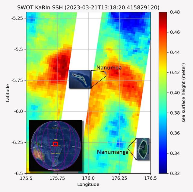
The recently launched Surface Water and Ocean Topography (SWOT) mission collected data on sea levels around two of the inhabited islands of Tuvalu, a nation in the South Pacific Ocean that has been threatened with sea level rise that substantially exceeds the global average. The image shows two areas of red that indicate higher than normal sea levels around two of Tuvalu's inhabited islands, Nanumanga and Nanumea. The higher sea levels were likely caused by internal tides or circular currents called eddies. The SWOT data illuminates for the first time these small ocean features that, when they occur on top of rising sea levels, can lead to episodic flooding along coastlines. The Tuvalu data was collected March 21, 2023. Rising seas are a direct consequence of climate change. On a global scale, the combination of warming ocean waters and ice melt from glaciers and ice sheets is leading to sea level rise that is occurring at an ever-increasing rate. The current rate of rise is more than 0.15 inches (4 millimeters) per year, an increase from 0.08 inches (2 millimeters) per year in 1993. This seemingly small increase holds great significance for coastal communities that have seen more than a century of persistent sea level rise. The gap between the average high tide and flooding conditions has narrowed, and coastal impacts driven by sea level rise have increased in frequency and severity in recent years. This is particularly true for low-lying island nations like Tuvalu, located about 620 miles (1,000 kilometers) north of Fiji. Sea level rise does not occur at the same rate everywhere across the globe, and can be exacerbated by natural ocean fluctuations that occur over time periods from years to decades. For Tuvalu, the amount of sea level rise has been substantially higher than the global average over the past three decades. The amount of rise, when coupled with Tuvalu's low land elevations, places the country increasingly under threat. In the near term, sea level rise will combine with naturally occurring ocean variability and storms to exacerbate events like coastal flooding. Monitoring and understanding sea level change is critical for Tuvalu and other low-lying island nations. Launched on Dec. 16, 2022, from Vandenberg Space Force Base in central California, SWOT collected the Tuvalu sea level data during a period of commissioning, calibration, and validation. Engineers are checking out the performance of the satellite's systems and science instruments before the planned start of science operations in summer 2023. https://photojournal.jpl.nasa.gov/catalog/PIA25777
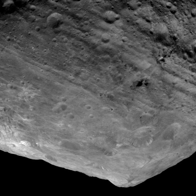
This image from NASA Dawn spacecraft is of the south pole region of the asteroid Vesta, a mountain is rising approximately 9 miles 15 kilometers above the floor of a crater.
This image from NASA Mars Reconnaissance Orbiter shows curious bright deposits in Syria Planum, a high elevation region near the summit of the Tharsis rise.
This colorful scene is situated in the Noctis Labyrinthus, perched high on the Tharsis rise in the upper reaches of the Valles Marineris canyon system as seen by NASA Mars Reconnaissance Orbiter.
This image captured by NASA Mars Reconnaissance Orbiter shows Tharsis Tholus, one of the smaller shield volcanoes on Mars massive Tharsis Rise.
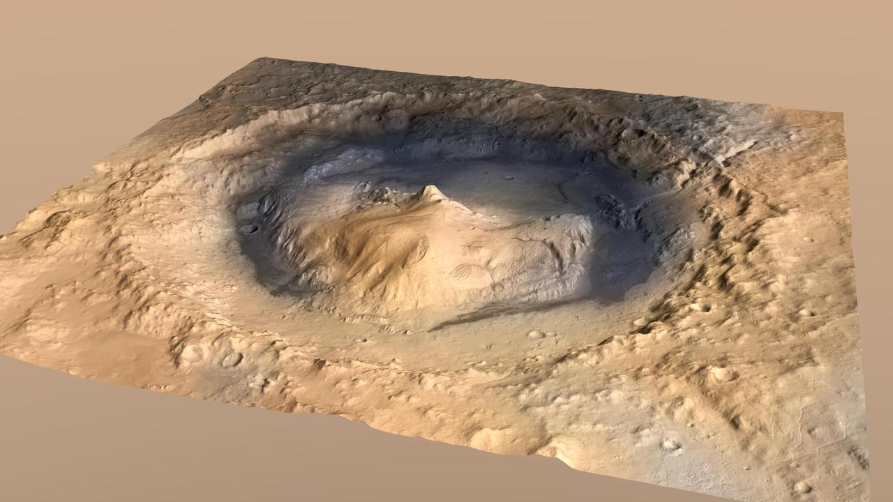
Gale Crater, where the rover Curiosity of NASA Mars Science Laboratory mission will land in August 2012, contains a mountain rising from the crater floor.
This perspective view shows the northern coastal plain of Costa Rica with the Cordillera Central, composed of a number of active and dormant volcanoes, rising in the background.
This perspective view taken in February 2000 from NASA Landsat and SRTM shows the Caribbean coastal plain of Costa Rica, with the Cordillera Central rising in the background.
The Artemis II zero gravity indicator, "Rise," is seen looped around the wrist of NASA astronaut Reid Wiseman, Artemis II commander, before the Artemis II crew appeared on stage for a crew return event, Saturday, Apr. 11, 2026, at Ellington Field in Houston, Texas. NASA’s Artemis II test flight took Commander Reid Wiseman, Pilot Victor Glover, and Mission Specialist Christina Koch from NASA, and Mission Specialist Jeremy Hansen from the CSA (Canadian Space Agency) on an approximately nine-day mission around the Moon and back to Earth. Photo Credit: (NASA/John Kraus)

NASA astronaut Reid Wiseman, Artemis II commander shows Rise, the zero gravity indicator that flew on the Artemis II mission, to U.S. Senator Susan Collins (R-ME) at an event at the Dirksen Senate Office Building, Tuesday, May 12, 2026, in Washington. NASA’s Artemis II mission took Wiseman, and crewmates NASA astronauts Victor Glover, pilot; Christina Koch, mission specialist; and CSA (Canadian Space Agency) astronaut Jeremy Hansen, mission specialist on a nearly 10-day journey around the Moon and back to Earth in April 2026. Photo Credit: (NASA/Aubrey Gemignani)
This false-color image obtained by NASA Magellan spacecraft shows the volcano Sapas Mons, which is located in the broad equatorial rise called Atla Regio. http://photojournal.jpl.nasa.gov/catalog/PIA00203
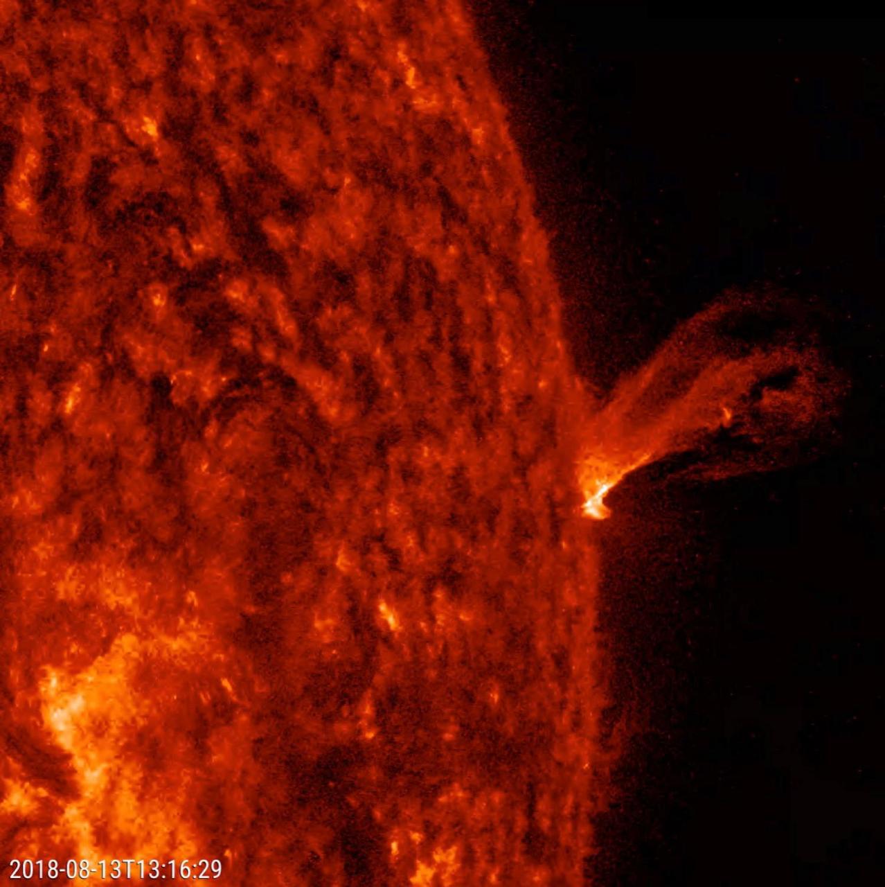
This close-up of the Sun from a two-hour period on Aug. 13, 2018 shows a minor eruption of charged particles rising up and twisting about before falling back into the Sun. Imaged in extreme ultraviolet light, these kinds of events are difficult to see except when they occur along the sun's edge, also known as the limb. At its peak the plasma rises several times the diameter of Earth. Movies are available at https://photojournal.jpl.nasa.gov/catalog/PIA22673

AS11-44-6549 (16-24 July 1969) --- This view from the Apollo 11 spacecraft shows Earth rising above the moon's horizon. The lunar terrain pictured is in the area of Smyth's Sea on the nearside. Coordinates of the center of the terrain are 86 degrees east longitude and 3 degrees north latitude. While astronauts Neil A. Armstrong, commander, and Edwin E. Aldrin Jr., lunar module pilot, descended in the Lunar Module (LM) "Eagle" to explore the Sea of Tranquility region of the moon, astronaut Michael Collins, command module pilot, remained with the Command and Service Modules (CSM) "Columbia" in lunar orbit.

AS11-44-6552 (16-24 July 1969) --- This view of Earth rising over the moon's horizon was taken from the Apollo spacecraft. The lunar terrain pictured is in the area of Smyth's Sea on the nearside. Coordinates of the center of the terrain are 85 degrees east longitude and 3 degrees north latitude. While astronaut Neil A. Armstrong, commander; and Edwin E. Aldrin Jr., lunar module pilot, descended in the Lunar Module (LM) "Eagle" to explore the Sea of Tranquility region of the moon, astronaut Michael Collins remained with the Command and Service Modules (CSM) "Columbia" in lunar orbit.
ISS040-E-020018 (25 June 2014) ---
STS102-324-028 (16 March 2001) --- The moon and Earth's limb were viewed from the Space Shuttle Discovery as it flew over the central Pacific Ocean with stratocumulus clouds below.

This image shows a bright, rectangular-looking landform surrounded by a dark floor. How did this feature get here if it looks so different than its surroundings? The feature resembles a plateau. Dark streaks mark steep slopes on its sides while the top appears flat. The slope streaks are not all the same age, as we see a variation in colors from faint to dark. Craters in a variety of sizes and ages pepper the entire rectangle, but the dark, textured floor has very few noticeable craters. The evidence suggests that this rectangular feature is a high-standing "island" of older land surrounded by one or more younger lava flows. This landmass is located in Amazonis Planitia, a smooth plains area potentially formed by large-scale lava floods between the Tharsis and Elysium volcanic regions. As lava flowed into this area, the rectangular plateau was too high to cover completely, leaving a bright spot sticking out of the dark basalt floor for us to find. https://photojournal.jpl.nasa.gov/catalog/PIA22725
This image taken at NASA Jet Propulsion Laboratory shows engineers testing the rover stand-up motions. The rover is in an elevated pose, preparing to fold down its wheels, descend and stand up.
In the upper central portion of this image is a patch of ground paler than its surroundings as seen by NASA Mars rover Curiosity after reaching the top of a rise called Panorama Point.

Large plumes of smoke rising from devastating wildfires burning near Los Angeles and San Diego on Sunday, October 26, 2003, are highlighted in this set of images from NASA Terra spacecraft.
Rising highest above the horizon in the right half of the image, captured by NASA Mars Exporation Rover, is a portion of the western rim of Endeavour Crater including a ridge informally named Cape Tribulation.
Islands of older high-standing terrain rise above a sea of relatively young, platy lava flows between two of the largest volcanoes in the solar system in this image from NASA Mars Odyssey spacecraft.
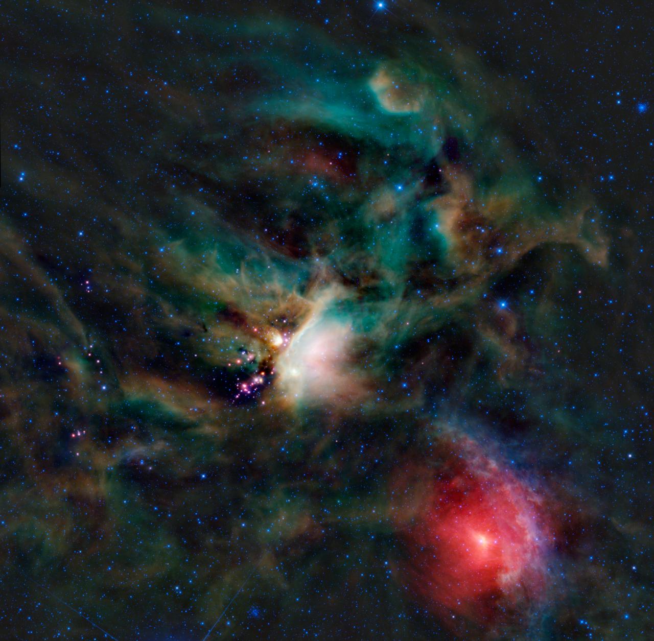
A rich collection of colorful astronomical objects is revealed in this picturesque image of the Rho Ophiuchi cloud complex from NASA Wide-field Infrared Explorer; the cloud is found rising above the plane of the Milky Way in the night sky.
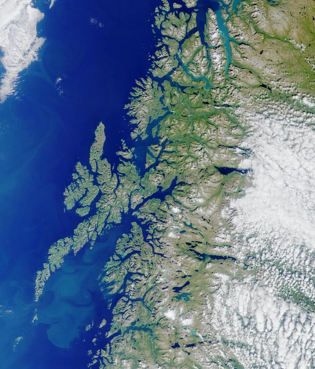
Lofoten Islands, Norway. Norway is deeply indented by fjords, rises precipitously to high plateaus, and is united with the ocean by numerous islands. This image from NASA Terra satellite is MISR Mystery Image Quiz #2.
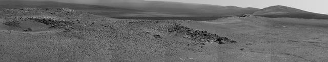
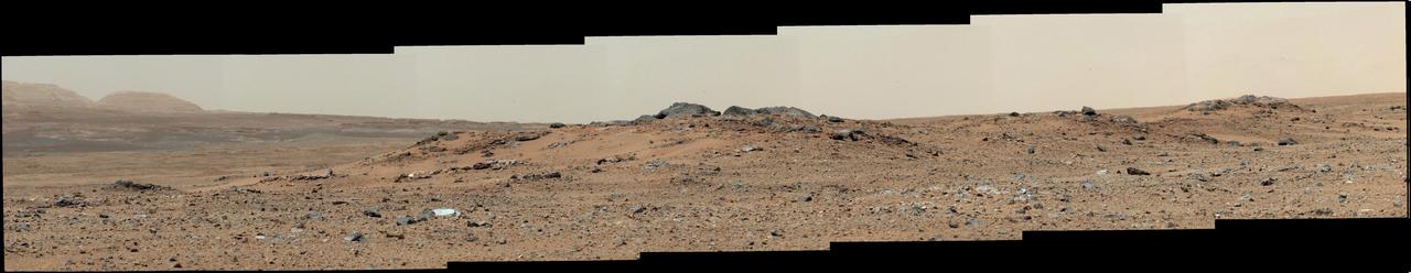
NASA Opportunity used its Pancam to record this view of the rise in the foreground, called Nobbys Head. This view is centered toward the south-southeast, with Opportunity next destination, Solander Point, toward the right edge of the view.
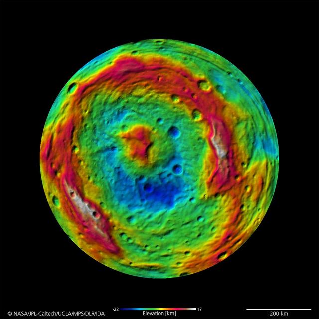
The terrain model of Vesta southern hemisphere shows a big circular structure, its rim rising above the interior of the structure. This false-color map of the giant asteroid Vesta is from the framing camera aboard NASA Dawn spacecraft.
The prominent rock in this image from NASA rover Curiosity, informally named East Bull Rock, is about 20 inches half a meter high. The rock-studded local rise dominating the image is called Elsie Mountain.
This image is a 3-D view in front of NASA Curiosity rover captured by the rover front left Hazard-Avoidance camera. The image is cropped but part of Mount Sharp is still visible rising above the terrain.
This is a portion of the first color 360-degree panorama from NASA Curiosity showing the rover a mountain at the center of Gale Crater called Mount Sharp, can be seen in the distance, to the left, beginning to rise up.
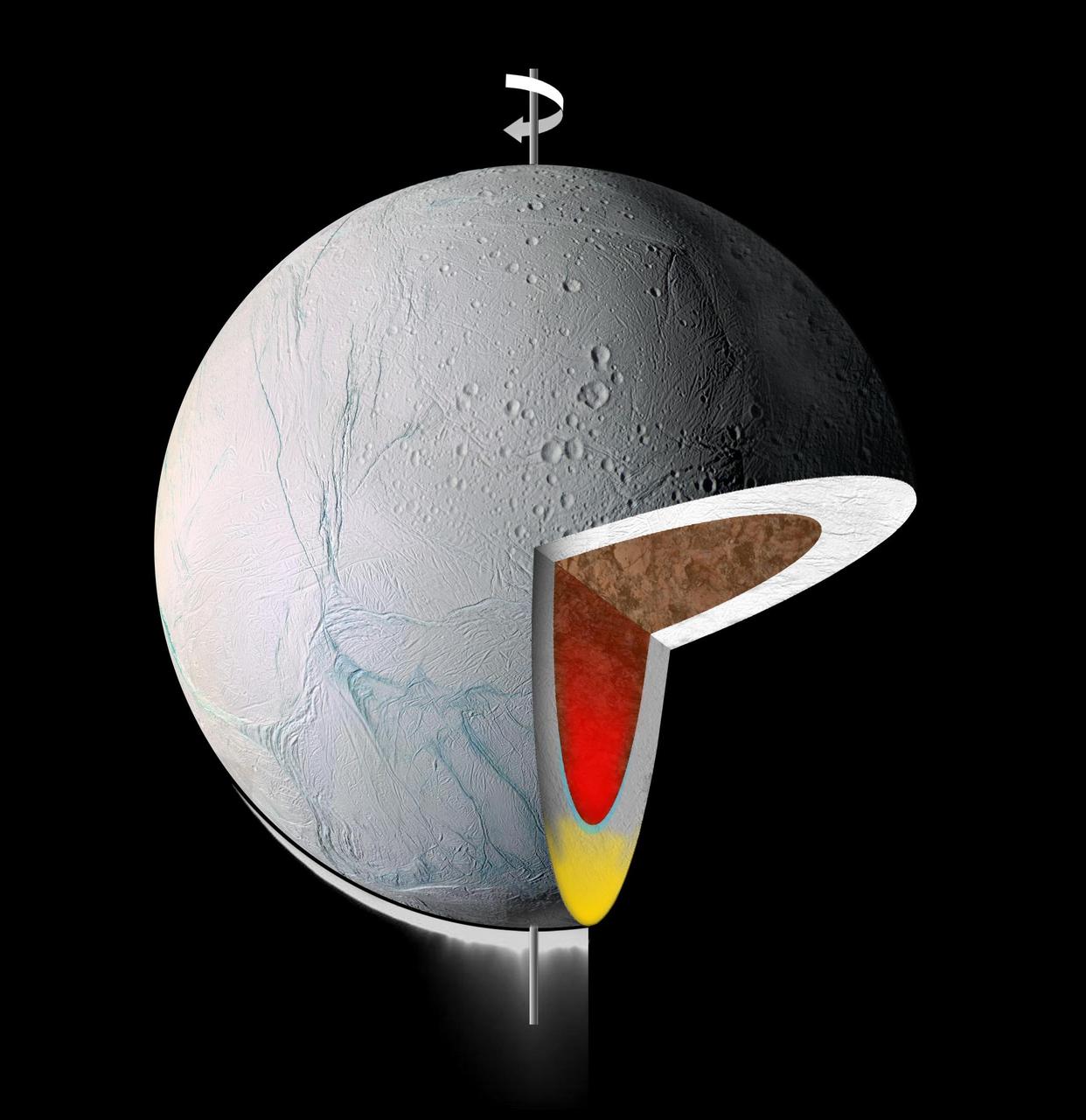
This graphic illustrates the interior of Saturn moon Enceladus. It shows warm, low-density material rising to the surface from within, in its icy shell yellow and/or its rocky core red
This image from NASA Terra spacecraft shows Baektu Mountain, an active volcano on the border between North Korea and China. Rising to 2744 m, its summit caldera is filled with a crater lake, Heaven Lake.
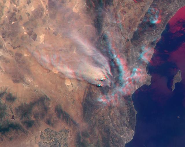
NASA Terra satellite took this anaglyph of several pyrocumulus clouds, created by the Station Fire, visible above the smoke plumes rising from the San Gabriel Mountains north of Los Angeles. 3D glasses are necessary to view this image.
This image by NASA Mars Odyssey spacecraft is within a region called Lunae Planum, west of NASA Viking 1 landing site, that marks the transition between the Tharsis rise, a giant volcanic complex, and the northern lowland plains.
NASA Terra spacecraft shows Mount Cameroon, an active volcano in Cameroon near the Gulf of Guinea. It is one of Africa largest volcanoes, rising over 4,000 meters, with more than 100 small cinder cones.
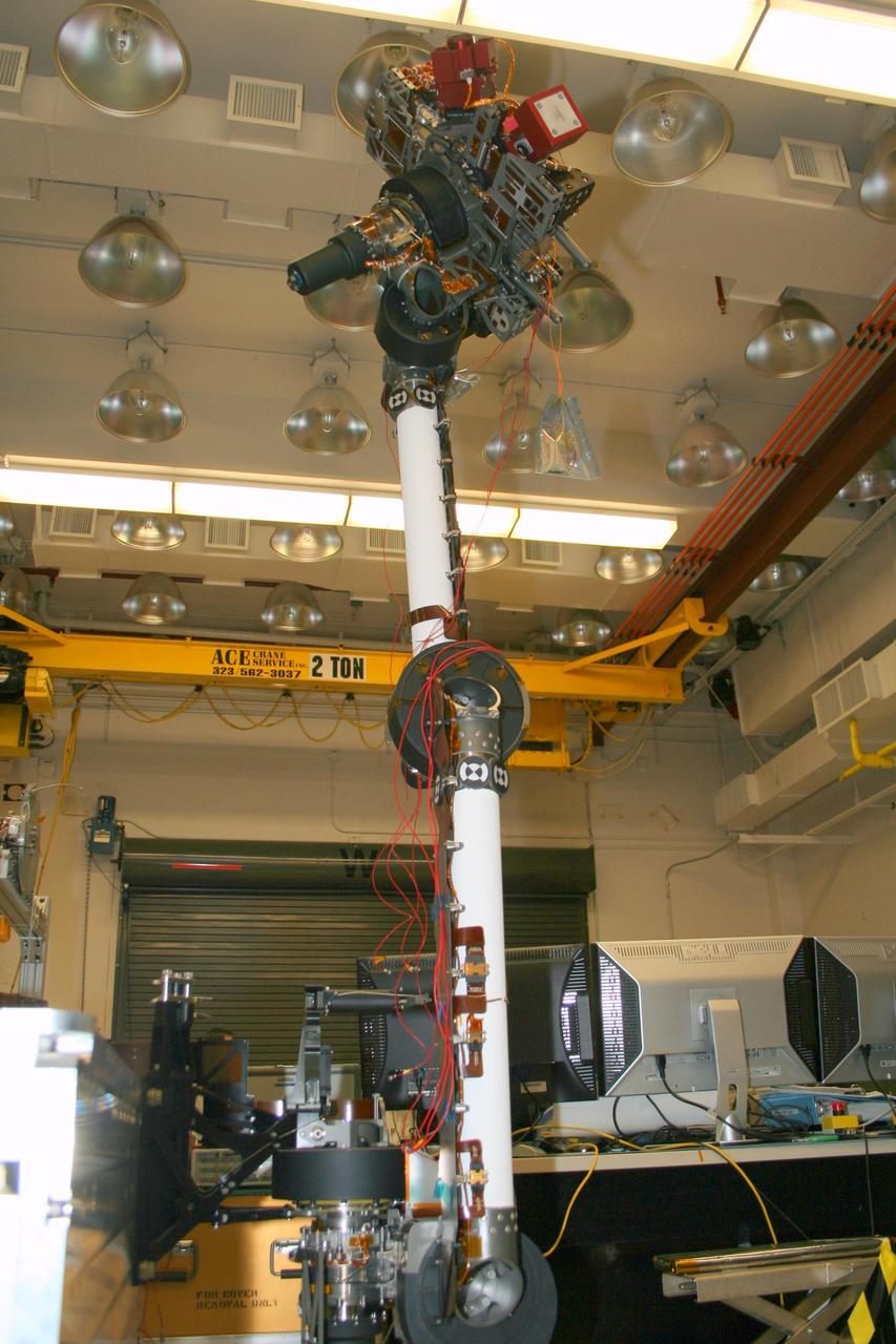
In the middle of this image taken at the Jet Propulsion Laboratory, the long robotic arm of NASA Mars Science Laboratory rises straight up toward the ceiling of the lab where it is being tested.
A rise topped by two gray rocks near the center of the scene is informally named Twin Cairns Island as seen by NASA Mars rover Curiosity. The center of the scene is toward the southwest.
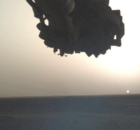
NASA's InSight lander snapped a series of images of the Sun rising and setting on Mars using the camera on its robotic arm on April 10, 2022, the 1,198th Martian day, or sol, of the mission. https://photojournal.jpl.nasa.gov/catalog/PIA25178

This MOC image shows billowing clouds of dust rising from a storm southeast of Hellas Planitia. The dust storm in this case obscured the Mars Orbiter Camera view of the martian surface
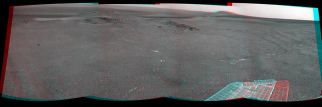
NASA Mars Exploration Rover Opportunity recorded this 3D view of a rise called Nobbys Head during a stop on a multi-week southward drive between two raised segments of the west rim of Endeavour Crater.