
NASA Airborne Snow Observatory measurements of snow water equivalent top image and snow albedo, or reflectivity bottom image for the Tuolumne River Basin in California Sierra Nevada on April 21, 2013.
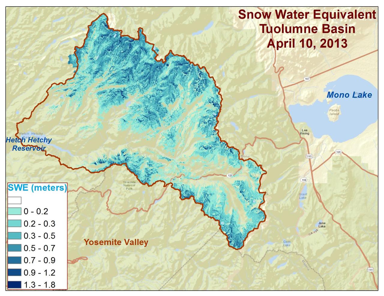
Spatial distribution of snow water equivalent across the Tuolumne River Basin from April 10 to June 1, 2013 as measured by NASA Airborne Snow Observatory.
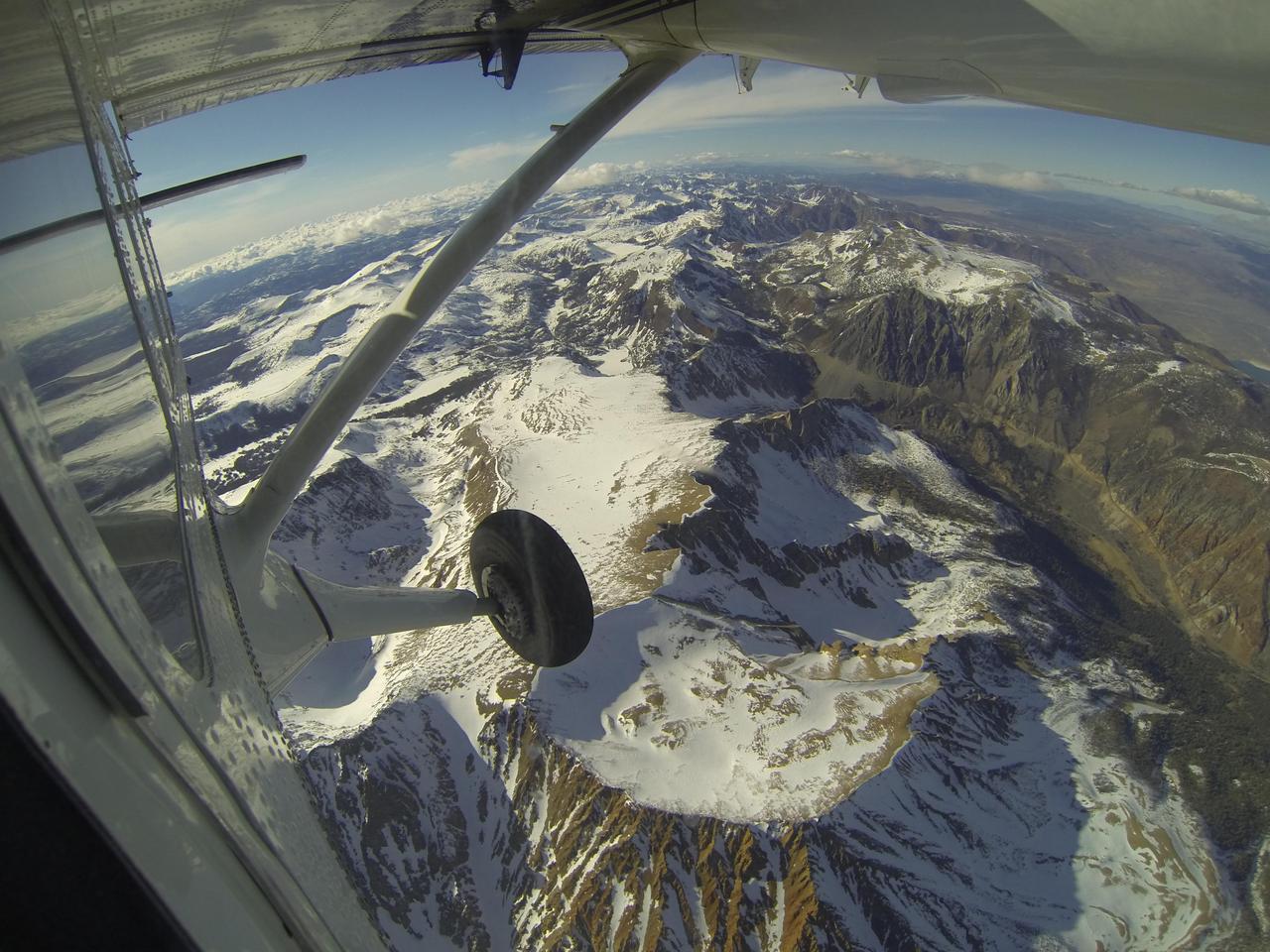
Mt. Dana and Dana Plateau in the Tuolumne River Basin within Yosemite National Park, Calif., as seen out the window of a Twin Otter aircraft carrying NASA Airborne Snow Observatory on April 3, 2013.
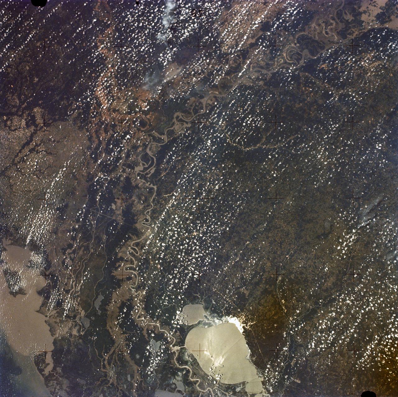
Lake Murray, a manmade reservoir, lies between the Fly and Strickland River Basins, Papua, New Guinea (7.0S, 141.5E). The region, photographed in sunglint, shows the water level in the reservoir and the full extent of the drainage basins of both river systems as the rivers meander through wide alluvial floodplains. Some forest clearing can be seen in places throughout the region, but most of the area remains in closed canopy forest.
SL2-05-422 (22 June 1973) --- This section of the lower Mississippi River (34.0N, 90.0W) known as the Yazoo Basin, is characterized by a wide expanse of rich river bottomland with many oxbow lakes, the remains of the many changes in the riverbed over the course of many thousands of years. This soil is very fertile and productive but the region is prone to flooding. In this view, some of the back areas around the Delta National Forest show the effects of heavy spring rains. Photo credit: NASA

A paper led by researchers at NASA's Jet Propulsion Laboratory estimates the total volume of water in Earth's rivers – called river storage – on average between 1980 and 2009, and maps out the results for the planet's major hydrological regions. This graphic, adapted from data gathered for the paper, indicates the amount of storage by hydrologic regions that contain one or more river basins, with shades of blue deepening as the amount of storage increases. The paper, published in Nature Geoscience in April 2024, calculated Earth's river storage at about 539 cubic miles (2,246 cubic kilometers), and found that the Amazon River basin, shown in dark blue in South America, was the region with the most storage, with 204 cubic miles (850 cubic kilometers), or about 38% of the global total. The study also estimated the flow of water through more than 3 million segments of river around the world and identified several locations marked by intense human water use, including parts of the Colorado River basin in the United States, portions of the Amazon basin in South America, the Orange River basin in southern Africa, and the Murray-Darling basin in southeastern Australia. https://photojournal.jpl.nasa.gov/catalog/PIA26119
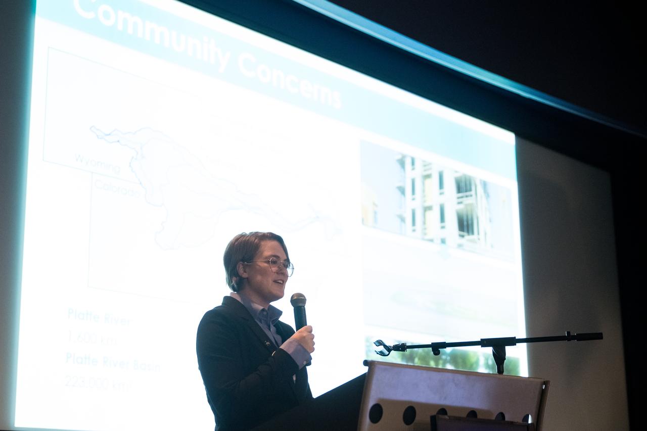
Olivia Kirkland speaks about her project, Platte River Basin Water Resources II, Tuesday, August 6, 2024, at the Mary W. Jackson NASA Headquarters building in Washington. Every summer early career researchers from NASA’s DEVELOP National Program come to NASA Headquarters and present their research projects. DEVELOP is a training and development program where early career researchers work on Earth science projects, mentored by science advisors from NASA and partner agencies, and provide research results to local communities. Photo Credit: (NASA/Aubrey Gemignani)
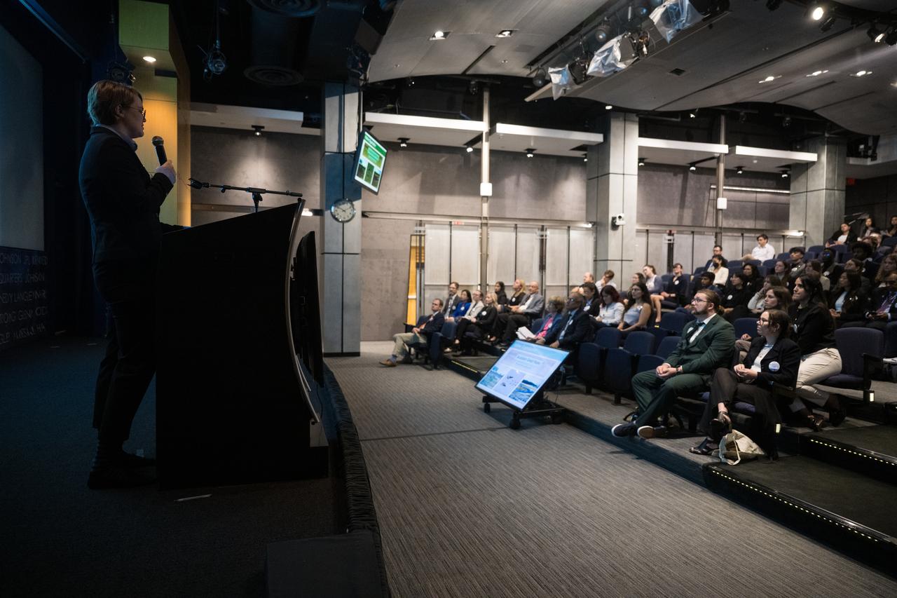
Olivia Kirkland speaks about her project, Platte River Basin Water Resources II, Tuesday, August 6, 2024, at the Mary W. Jackson NASA Headquarters building in Washington. Every summer early career researchers from NASA’s DEVELOP National Program come to NASA Headquarters and present their research projects. DEVELOP is a training and development program where early career researchers work on Earth science projects, mentored by science advisors from NASA and partner agencies, and provide research results to local communities. Photo Credit: (NASA/Aubrey Gemignani)
In the northeast Sichuan province of China lies the Sichuan Basin, surrounded by mountains on all sides and drained by the Yangtzee River. The basin is considered the breadbasket of China. On the northeast edge, flat-lying Jurassic to Cretaceous sandstones have been eroded to form an intricately carved landscape of upland fields and lowland streams and valleys. The image was acquired September 11, 2016, covers an area of 36 by 37 kilometers, and is located at 31.9 degrees north, 105.4 degrees east. https://photojournal.jpl.nasa.gov/catalog/PIA23532
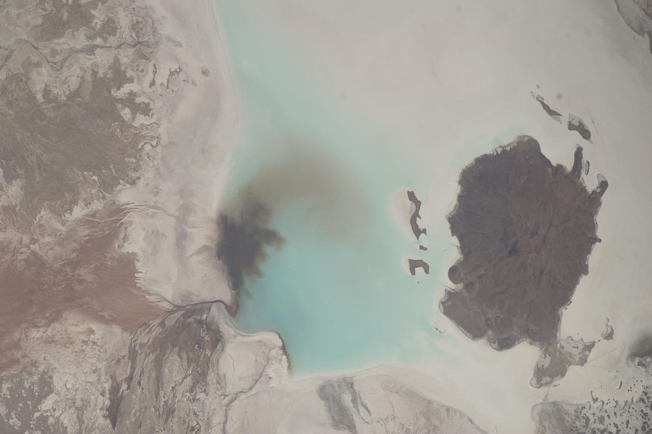
51F-37-059 (29 July-6 Aug 1985) --- The mouth of the Betsiboka River in northwest Madagascar is seen. The estuary at Mahajanga is being quickly filled with river borne sediments due to poor land management, mainly deforest-action in the river basin. Changes in the estuary can be seen from one Shuttle flight to the next.

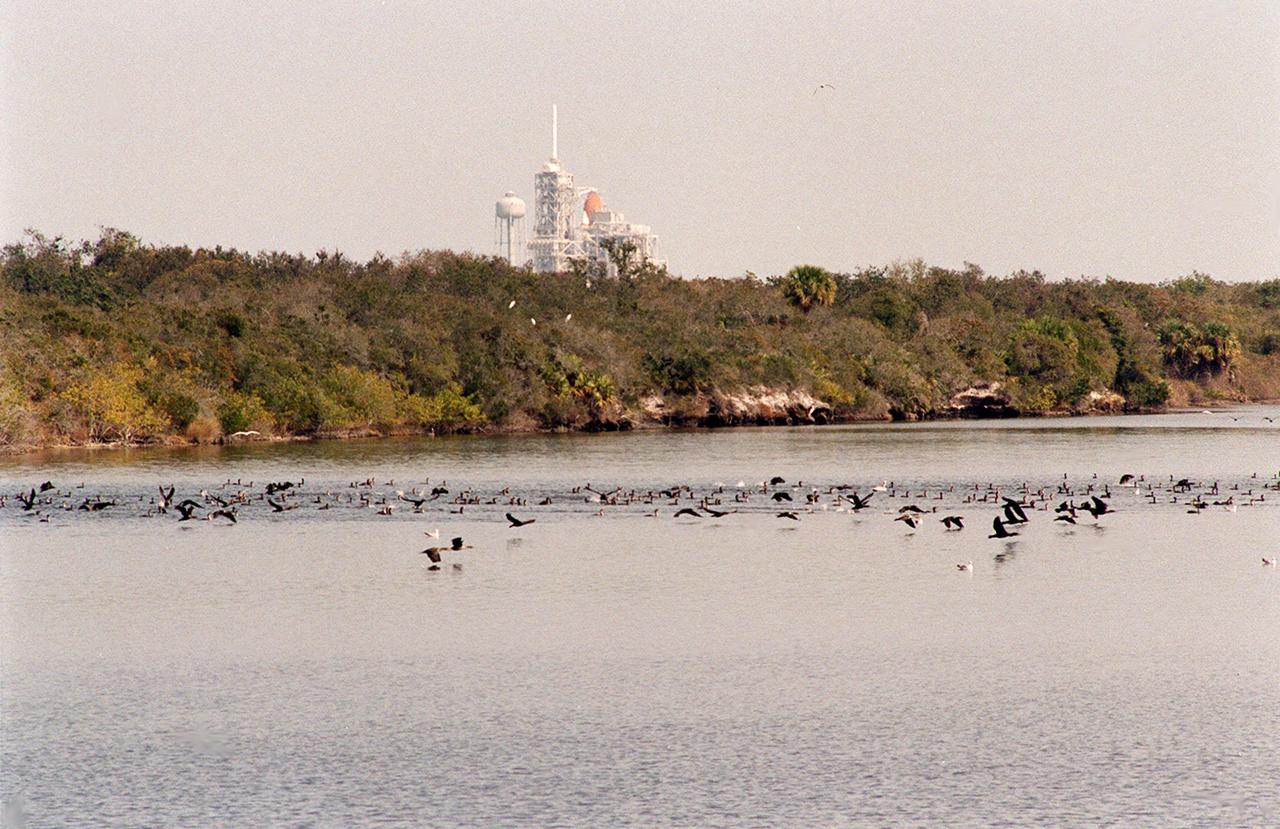
KENNEDY SPACE CENTER, FLA. -- The water in the turn basin, east of the Vehicle Assembly Building and next to the crawlerway, teems with fish and draws white pelicans, gray pelicans, cormorants, sea gulls and more looking for a meal. The turn basin is part of the Indian River Lagoon, composed of Mosquito Lagoon to the north, Banana River and Creek to the south and the Indian River to the west. The Indian River Lagoon has one of the most diverse bird populations anywhere in America. Also, nearly one-third of the nation's manatee population lives here or migrates through the lagoon seasonally. The lagoon varies in width from ½ mile to 5 miles and averages only 3 feet in depth
KENNEDY SPACE CENTER, FLA. -- The water in the turn basin, east of the Vehicle Assembly Building and next to the crawlerway, teems with fish and draws white pelicans, gray pelicans, cormorants, sea gulls and more looking for a meal. The turn basin is part of the Indian River Lagoon, composed of Mosquito Lagoon to the north, Banana River and Creek to the south and the Indian River to the west. The Indian River Lagoon has one of the most diverse bird populations anywhere in America. Also, nearly one-third of the nation's manatee population lives here or migrates through the lagoon seasonally. The lagoon varies in width from ½ mile to 5 miles and averages only 3 feet in depth
iss073e0818427 (Oct. 2, 2025) --- The Bassac River surrounds Cù Lao Dung, a river islet district in southern Vietnam, before emptying into the South China Sea. The river’s brown waters at its mouth result from massive amounts of silt, clay, and organic matter carried from upstream regions of the Mekong River Basin, combined with tidal forces from the sea that stir up sediment. This photograph was taken from the International Space Station as it orbited 260 miles above Earth.
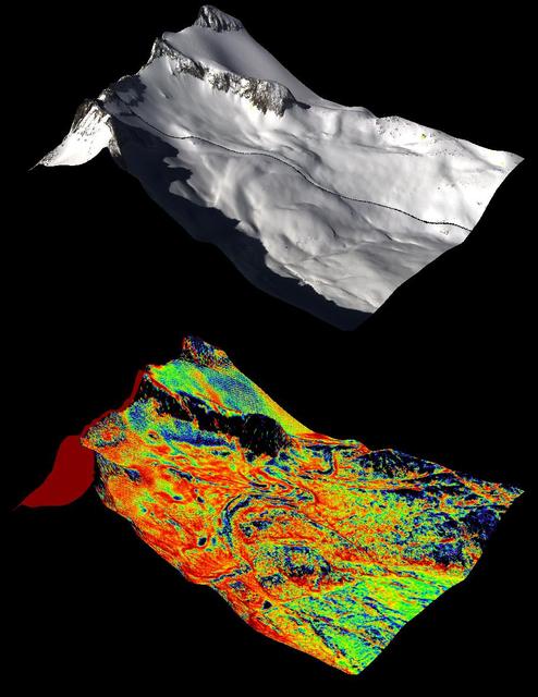
A natural color image of Mt. Lyell, the highest point in the Tuolumne River Basin top image is compared with a three-dimensional color composite image of Mt. Lyell from NASA Airborne Snow Observatory depicting snow depth bottom image.
STS054-80-024 (13-19 Jan 1993) --- As the Shuttle was passing southeast over the coast of India, approaching the Bay of Bengal, Endeavour's crew took this picture of the Godavari River Delta. The sun glint pattern was centered directly over the delta and highlighted well the intricate drainage pattern. Offshore, water features associated with current boundaries and river plumes are readily visible. The line of clouds along the coast south of the delta suggest that surface winds are blowing onshore from the Bay of Bengal. As the air passes over the warmer coastal water and land, it is warmed and begins to rise. The moisture in the air condenses, forming a line of low-level clouds.
SL2-05-397 (22 June 1973) --- New Orleans, Louisiana, Mississippi River, and Lake Pontchartrain (31.0N, 91.0W) can all be seen in this single detailed view. The marshlands of the Atchafalaya Basin, previously the main drainage way for the Mississippi River, can be seen to be partially silted as a result of sediments. The long narrow field patterns fronting on the river is called the "Long Lot" system of equal land distribution based on the French Napoleonic Civil Code. Photo credit: NASA
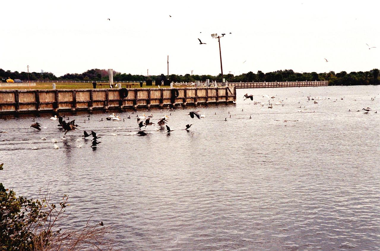
KENNEDY SPACE CENTER, FLA. -- Birds by the score, especially gray and white pelicans, cormorants, sea gulls, herons and ospreys, flock to the turn basin east of the Vehicle Assembly Building in a feeding frenzy as schools of fish fill the waters. In the background is Launch Pad A with Space Shuttle Endeavour waiting for launch on Friday, Feb. 11 for mission STS-99. The basin is part of the Indian River Lagoon, which is made up of Mosquito Lagoon to the north, Banana River and Creek to the south and the Indian River to the west. It is called a lagoon because it is a body of water separated from the ocean by barrier islands, with limited exchange with the ocean through inlets. The Indian River Lagoon has one of the most diverse bird populations anywhere in America. Also, nearly one-third of the nation's manatee population lives here or migrates through the lagoon seasonally. The lagoon varies in width from ½ mile to 5 miles and averages only 3 feet in depth

KENNEDY SPACE CENTER, FLA. -- Birds by the score, especially gray and white pelicans, cormorants, sea gulls, herons and ospreys, flock to the turn basin east of the Vehicle Assembly Building in a feeding frenzy as schools of fish fill the waters. In the background is Launch Pad A with Space Shuttle Endeavour waiting for launch on Friday, Feb. 11 for mission STS-99. The basin is part of the Indian River Lagoon, which is made up of Mosquito Lagoon to the north, Banana River and Creek to the south and the Indian River to the west. It is called a lagoon because it is a body of water separated from the ocean by barrier islands, with limited exchange with the ocean through inlets. The Indian River Lagoon has one of the most diverse bird populations anywhere in America. Also, nearly one-third of the nation's manatee population lives here or migrates through the lagoon seasonally. The lagoon varies in width from ½ mile to 5 miles and averages only 3 feet in depth
ISS018-E-025705 (30 Jan. 2009) --- Betsiboka River floods in Madagascar are featured in this image photographed by an Expedition 18 crewmember on the International Space Station. Between Jan. 18-20, 2009, Tropical Storm Eric swept along the east coast of the island nation of Madagascar. Rain from this storm fell in the catchment of the Betsiboka River, one of the main rivers in northern Madagascar. In an unlikely coincidence, a larger storm, Cyclone Fanele crossed central Madagascar the next day on Jan. 21, with its outer bands dropping more rain in the Betsiboka basin. By the time this image was taken on the Jan. 30, the river was flooding all along its length.
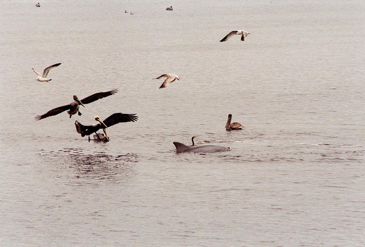
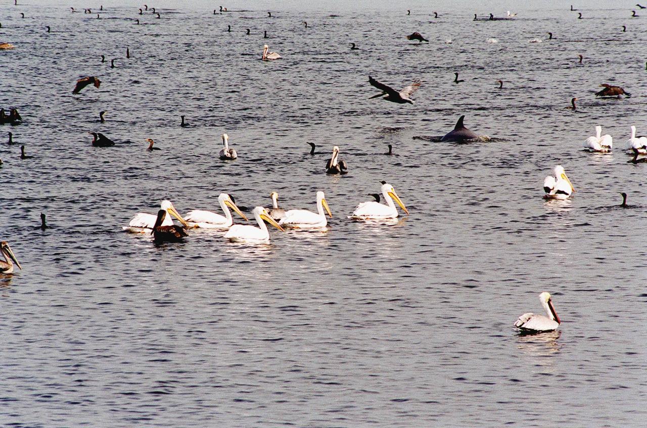
KENNEDY SPACE CENTER, FLA. -- Hundreds of birds, especially gray and white pelicans and cormorants, cover the water in the turn basin, located east of the Vehicle Assembly Building and next to the crawlerway. The basin is teeming with fish, attracting the crowd for a meal. The turn basin is part of the Indian River Lagoon, composed of Mosquito Lagoon to the north, Banana River and Creek to the south and the Indian River to the west. The lagoon has one of the most diverse bird populations anywhere in America, plus many different species of oceanic and lagoon fish, shellfish and dolphins. Also, nearly one-third of the nation's manatee population lives here or migrates through the Lagoon seasonally. The Lagoon varies in width from ½ mile to 5 miles and averages only 3 feet in depth

KENNEDY SPACE CENTER, FLA. -- Hundreds of birds, especially gray and white pelicans and cormorants, cover the water in the turn basin, located east of the Vehicle Assembly Building and next to the crawlerway. The basin is teeming with fish, attracting the crowd for a meal. The turn basin is part of the Indian River Lagoon, composed of Mosquito Lagoon to the north, Banana River and Creek to the south and the Indian River to the west. The lagoon has one of the most diverse bird populations anywhere in America, plus many different species of oceanic and lagoon fish, shellfish and dolphins. Also, nearly one-third of the nation's manatee population lives here or migrates through the Lagoon seasonally. The Lagoon varies in width from ½ mile to 5 miles and averages only 3 feet in depth
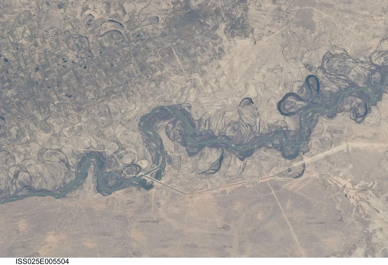
ISS025-E-005504 (30 Sept. 2010) --- Syr Dar’ya River floodplain in Kazakhstan, central Asia is featured in this image photographed by an Expedition 25 crew member on the International Space Station. Central Asia’s most important cotton-growing region is concentrated in the floodplain of the Syr Dar’ya, and is irrigated by water from the river. The floodplain is shown here as a tangle of twisting meanders and loops (center). The darkest areas are brushy vegetation along the present course (filled with blue-green water); wisps of vegetation are also visible along flanking swampy depressions, or sloughs. An older floodplain appears as an area of more diffuse dark vegetation (upper left), where a pattern of relict meander bends is overlain by a rectangular pattern of cotton fields. The straight channel of a new diversion canal—one of sixteen from this point downstream—can be seen along the east bank of the river. The older floodplain area is fed from the Chardara Reservoir immediately upstream (not shown). Half the river flow is controlled from reservoirs, and half from direct water take-off from canals. By contrast with the intensive agricultural use of water shown here, upstream water control in the mountain valleys is oriented more toward power generation. The river flows for a total distance of 2,200 kilometers from the Tien Shan Mountains westward and northwestward to the Aral Sea—the dying waterbody at the low point of the basin far to the northwest. Withdrawals of water from the river for agriculture have continued for many decades. Although the Syr Dar’ya is the second largest river flowing into the sea, its discharge is not very large. As such, it has been easily depleted, with none of its water today reaching the Aral Sea. Control of the river is vested in the Syr Dar’ya Basin Water Organization run by nations with territory in the Syr Dar’ya basin. Some of the organization’s main efforts are accurate gauging of water use along the river course, and repair of canals to reduce widespread water loss by leakage.
The Mississippi Watershed is the largest drainage basin in North America at 3.2 million square kilometers in area. The USGS has created a database of this area which indicates the direction of waterflow at each point. By assembling these directions into streamflows, it is possible to trace the path of water from every point of the area to the mouth of the Mississippi in the Gulf of Mexico. This animation starts with the points furthest from the Gulf and reveals the streams and rivers as a steady progression towards the mouth of the Mississippi until all the major rivers are revealed. The speed of the reveal of the rivers is not dependent on the actual speed of the water flow. The reveal proceeds at a constant velocity along each river path, timed so that all reveals reach the mouth of the Mississippi at the same time. This animation does not show actual flow rates of the rivers. All rivers are shown with identical rates. The river colors and widths correspond to the relative lengths of river segments. Credit: NASA's Scientific Visualization Studio/Horace Mitchell Go here to download this video: <a href="http://svs.gsfc.nasa.gov/4493" rel="nofollow">svs.gsfc.nasa.gov/4493</a>
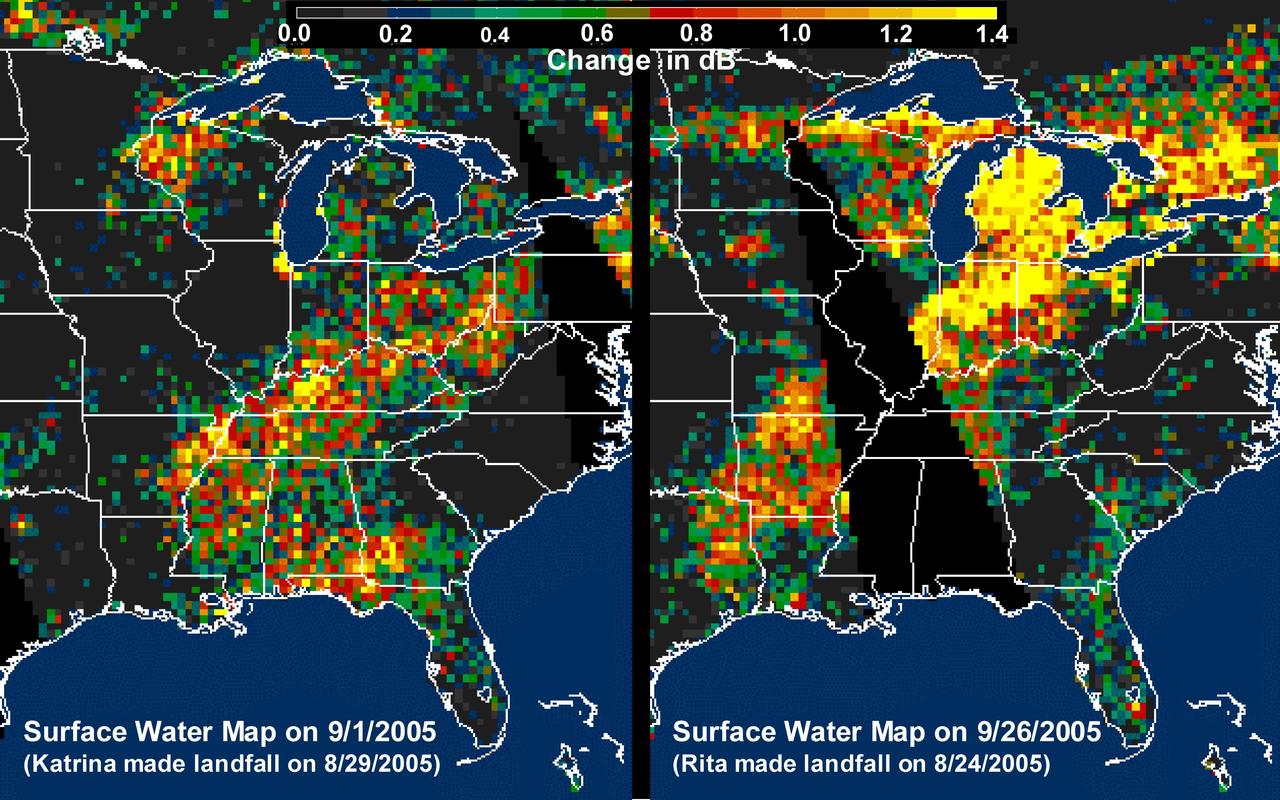
The above images, derived from NASA QuikScat satellite data, show the extensive pattern of rain water deposited by Hurricanes Katrina and Rita on land surfaces over several states in the southern and eastern United States. These results demonstrate the capability of satellite scatterometers to monitor changes in surface water on land. The color scale depicts increases in radar backscatter (in decibels) between the current measurement and the mean of measurements obtained during the previous two weeks. The backscatter can be calibrated to measure increases in surface soil moisture resulting from rainfall. The yellow color corresponds to an increase of approximately 10 percent or more in surface soil moisture according to the calibration site of Lonoke, Ark. The two hurricanes deposited excessive rainfall over extensive regions of the Mississippi River basin. Basins the size of the Mississippi can take up to several weeks before such excess rainfall significantly increases the amount of river discharge in large rivers such as the Mississippi. With hurricane season not over until November 30, the potential exists for significant flooding, particularly if new rain water is deposited by new hurricanes when river discharge peaks up as a result of previous rainfalls. River discharge should be closely monitored to account for this factor in evaluating potential flood conditions in the event of further hurricanes. http://photojournal.jpl.nasa.gov/catalog/PIA03029
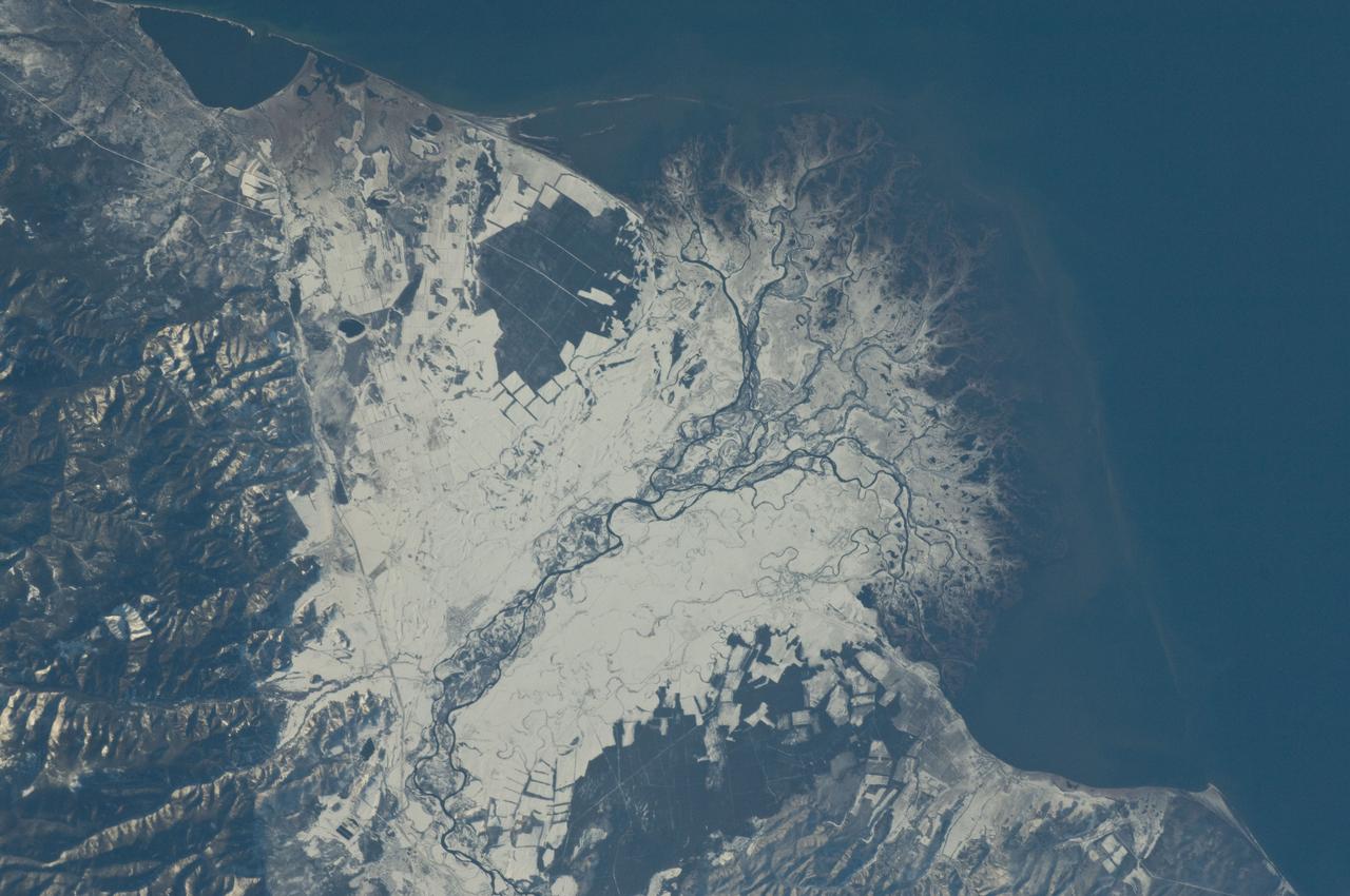
ISS029-E-037915 (3 Nov. 2011) --- Snowfall on the Selenga River Delta, Russian Federation is featured in this image photographed by an Expedition 29 crew member on the International Space Station. This photograph illustrates the Selenga River Delta built out into Lake Baikal in Russia. The Selenga River delta (center) is lobate in form, with an intricate network of distributary channels and levees surrounded by marshlands building out into Lake Baikal. This suggests that development of the delta is governed by the sediment load carried by the river, and any modifications of form due to lake tides or waves are relatively minor. Further out, dark brown depositional bars are visible forming a rough arc marking the edge of the delta. Snow cover on the river floodplain highlights numerous secondary channels, as well as channels previously occupied by the river but now abandoned. The regular outlines of agricultural fields to the southwest and northeast of the river are also highlighted by the snow cover. Lake Baikal is a World Heritage Site. The Selenga River is the major contributor of water to Lake Baikal; it occupies approximately 82 per cent of the watershed area for the lake. The wetlands of the Selenga River delta are designated as a RAMSAR site and provide valuable habitat for more than 170 species of birds, including many that are migrating. Like Baikal, the Selenga Delta is home to unique ecosystems, including more than 70 rare or endangered species of plants and animals. Waters of the Selenga River serve many (and differing) uses in both Mongolia and Russia, including support of agriculture, provision of drinking water, light industry, mining, recreation, and tourism. These uses also contribute to degradation of the river water quality, downstream availability of water, and ecological impacts. For example, a pulp and paper plant in the city of Selenginsk (lower left) has been tied to high levels of pollution in the river. International efforts to integrate management of the Selenga River basin for both ecological and economic sustainability are ongoing.
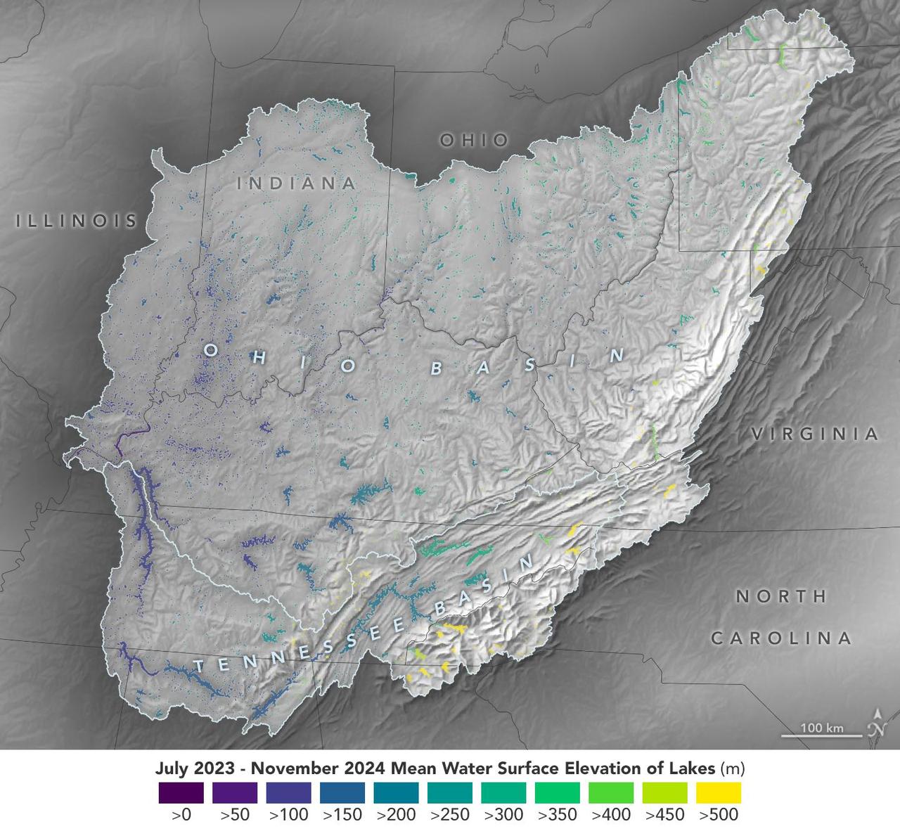
This visualization based on data from the Surface Water and Ocean Topography (SWOT) satellite shows the average water level for lakes and reservoirs in the Ohio River Basin from July 2023 to November 2024. Yellow indicates values greater than 1,600 feet (500 meters) above sea level, and dark purple represents water levels less than 330 feet (100 meters). Comparing how such levels change can help hydrologists measure water availability over time in a local area or across a watershed. Since early 2023, SWOT has been measuring the height of nearly all water on Earth's surface – including oceans, lakes, reservoirs, and rivers – covering nearly the entire globe at least once every 21 days. The satellite also measures the horizontal extent of water in freshwater bodies. Earlier this year, the SWOT mission started making validated data (processed measurements that have been checked for accuracy) publicly available. https://photojournal.jpl.nasa.gov/catalog/PIA26188

KENNEDY SPACE CENTER, FLA. -- A gray and a white pelican glide down to the water near a dolphin and cormorant in the turn basin to search for a meal in the fish-teeming water. Sea gulls also approach. The turn basin, which is east of the Vehicle Assembly Building and next to the crawlerway, is part of the Indian River Lagoon, composed of Mosquito Lagoon to the north, Banana River and Creek to the south and the Indian River to the west. The lagoon has one of the most diverse bird populations anywhere in America, plus many different species of oceanic and lagoon fish, shellfish and dolphins. Also, nearly one-third of the nation's manatee population lives here or migrates through the Lagoon seasonally. The Lagoon varies in width from ½ mile to 5 miles and averages only 3 feet in depth

KENNEDY SPACE CENTER, FLA. -- The water in the turn basin, located east of the Vehicle Assembly Building and next to the crawlerway, teems with fish and draws white pelicans, gray pelicans, cormorants, sea gulls and one of several dolphins looking for a meal. The turn basin is part of the Indian River Lagoon, composed of Mosquito Lagoon to the north, Banana River and Creek to the south and the Indian River to the west. The lagoon has one of the most diverse bird populations anywhere in America, plus many different species of oceanic and lagoon fish, shellfish and dolphins. Also, nearly one-third of the nation's manatee population lives here or migrates through the lagoon seasonally. The lagoon varies in width from ½ mile to 5 miles and averages only 3 feet in depth
KENNEDY SPACE CENTER, FLA. -- A gray and a white pelican glide down to the water near a dolphin and cormorant in the turn basin to search for a meal in the fish-teeming water. Sea gulls also approach. The turn basin, which is east of the Vehicle Assembly Building and next to the crawlerway, is part of the Indian River Lagoon, composed of Mosquito Lagoon to the north, Banana River and Creek to the south and the Indian River to the west. The lagoon has one of the most diverse bird populations anywhere in America, plus many different species of oceanic and lagoon fish, shellfish and dolphins. Also, nearly one-third of the nation's manatee population lives here or migrates through the Lagoon seasonally. The Lagoon varies in width from ½ mile to 5 miles and averages only 3 feet in depth
KENNEDY SPACE CENTER, FLA. -- The water in the turn basin, located east of the Vehicle Assembly Building and next to the crawlerway, teems with fish and draws white pelicans, gray pelicans, cormorants, sea gulls and one of several dolphins looking for a meal. The turn basin is part of the Indian River Lagoon, composed of Mosquito Lagoon to the north, Banana River and Creek to the south and the Indian River to the west. The lagoon has one of the most diverse bird populations anywhere in America, plus many different species of oceanic and lagoon fish, shellfish and dolphins. Also, nearly one-third of the nation's manatee population lives here or migrates through the lagoon seasonally. The lagoon varies in width from ½ mile to 5 miles and averages only 3 feet in depth
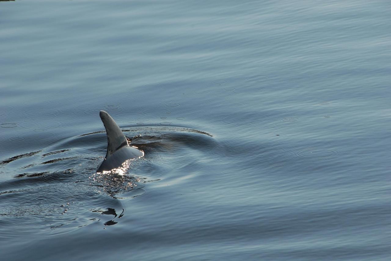
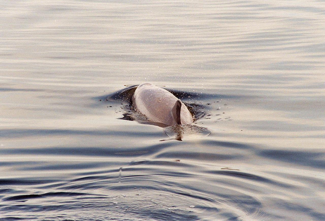
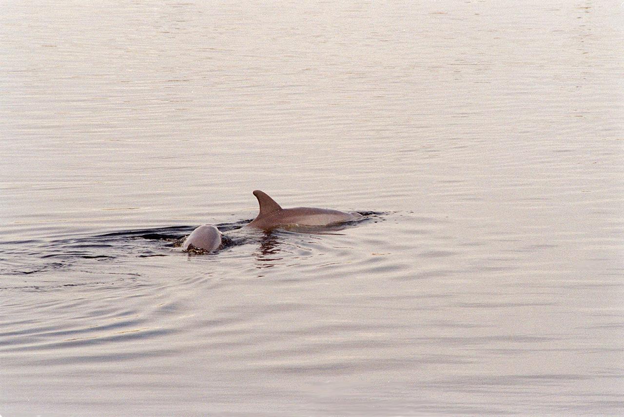
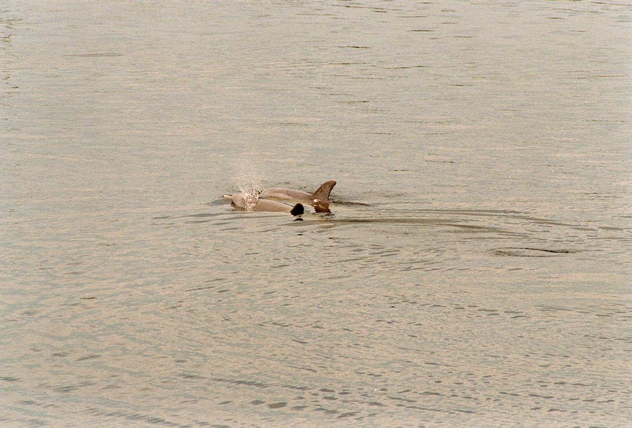
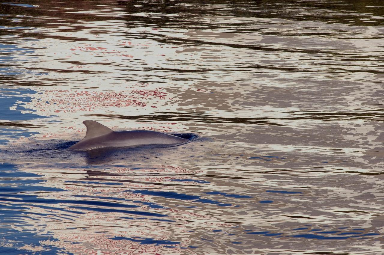
KENNEDY SPACE CENTER, FLA. -- A dolphin's dorsal fin cuts through the water in the Launch Complex 39 Area turn basin at NASA's Kennedy Space Center. The turn basin was carved out of the Banana River when Kennedy Space Center was built. Dolphins frequent bays and coastlines, usually in depths under 20 meters. While some pods take up permanent residence and establish home waters, others are migratory and swim considerable distances from coast to coast. Dolphins are a frequent sight in the rivers around Kennedy, which shares a boundary with the Merritt Island Wildlife Nature Refuge. Photo credit: NASA/George Shelton
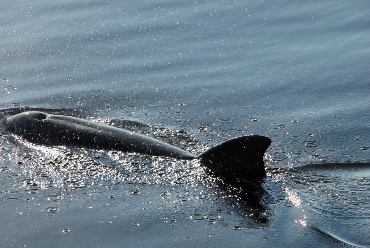
KENNEDY SPACE CENTER, FLA. -- A dolphin surfaces in the Launch Complex 39 Area turn basin at NASA's Kennedy Space Center. The turn basin was carved out of the Banana River when Kennedy Space Center was built. Dolphins frequent bays and coastlines, usually in depths under 20 meters. While some pods take up permanent residence and establish home waters, others are migratory and swim considerable distances from coast to coast. Dolphins are a frequent sight in the rivers around Kennedy, which shares a boundary with the Merritt Island Wildlife Nature Refuge. Photo credit: NASA/George Shelton
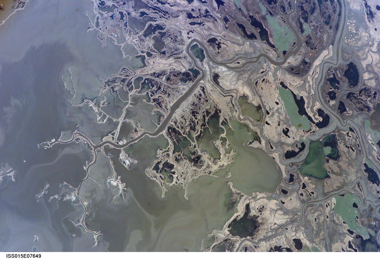
ISS015-E-07649 (11 May 2007) --- Saskatchewan River Delta, Manitoba, Canada is featured in this image photographed by an Expedition 15 crewmember on the International Space Station. This image highlights a portion of the Saskatchewan River delta extending into Cedar Lake in the Province of Manitoba. The Saskatchewan River watershed extends from the Rocky Mountains of Alberta through the plains of Saskatchewan and Manitoba. The construction of the Grand Rapids Dam to the southeast (not shown) in the 1960s flooded the Cedar Lake basin. This has resulted in the formation of numerous shallow, muddy lakes and bogs (dark green to dark grey irregular areas and at upper right) in and around the Saskatchewan River delta. The level of saturation in these bogs is such that peat (semiconsolidated plant and organic matter) deposits have formed; over long periods of time and under the right geological conditions, such deposits can become coal. The velocity of Saskatchewan River water slows significantly as it enters Cedar Lake; as the flow velocity drops, entrained sediment comprised of silt, clay, sand, and gravel is deposited at the river mouth. These deposits, called alluvium by geologists, account for much of the light tan to grey materials bordering the active channels visible in the image (Saskatchewan River, Summerberry River). According to scientists, fossil-bearing amber -- originating from Late Cretaceous (approximately 65-99 million years ago) coal deposits over a thousand kilometers to the west of Cedar Lake -- is also found in the deltaic sediments. As the deposits accumulate, old channels are abandoned and new channels are formed, as the river seeks more favorable flow paths into the lake, this process (known as avulsion) builds out the river delta over time. A typical "birds foot" delta form is currently being constructed at the mouth of the Saskatchewan River (lower left). The birds foot structure is approximately 13 kilometers wide. The Mississippi River's active delta, while having the same general form, is much larger by comparison -- it is approximately 50 kilometers wide.

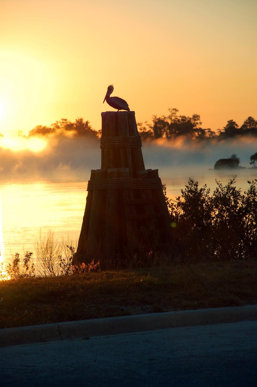
CAPE CANAVERAL, Fla. – A pelican is silhouetted against the rosy dawn sky as morning fog floats over the turn basin at NASA's Kennedy Space Center in Florida. Kennedy is surrounded by water: the Banana River, Banana Creek, Indian River Lagoon and the Atlantic Ocean, all of which provide scenes of beauty and nature that contrast with the high technology and power of the center. Photo credit: NASA/Ben Smegelsky
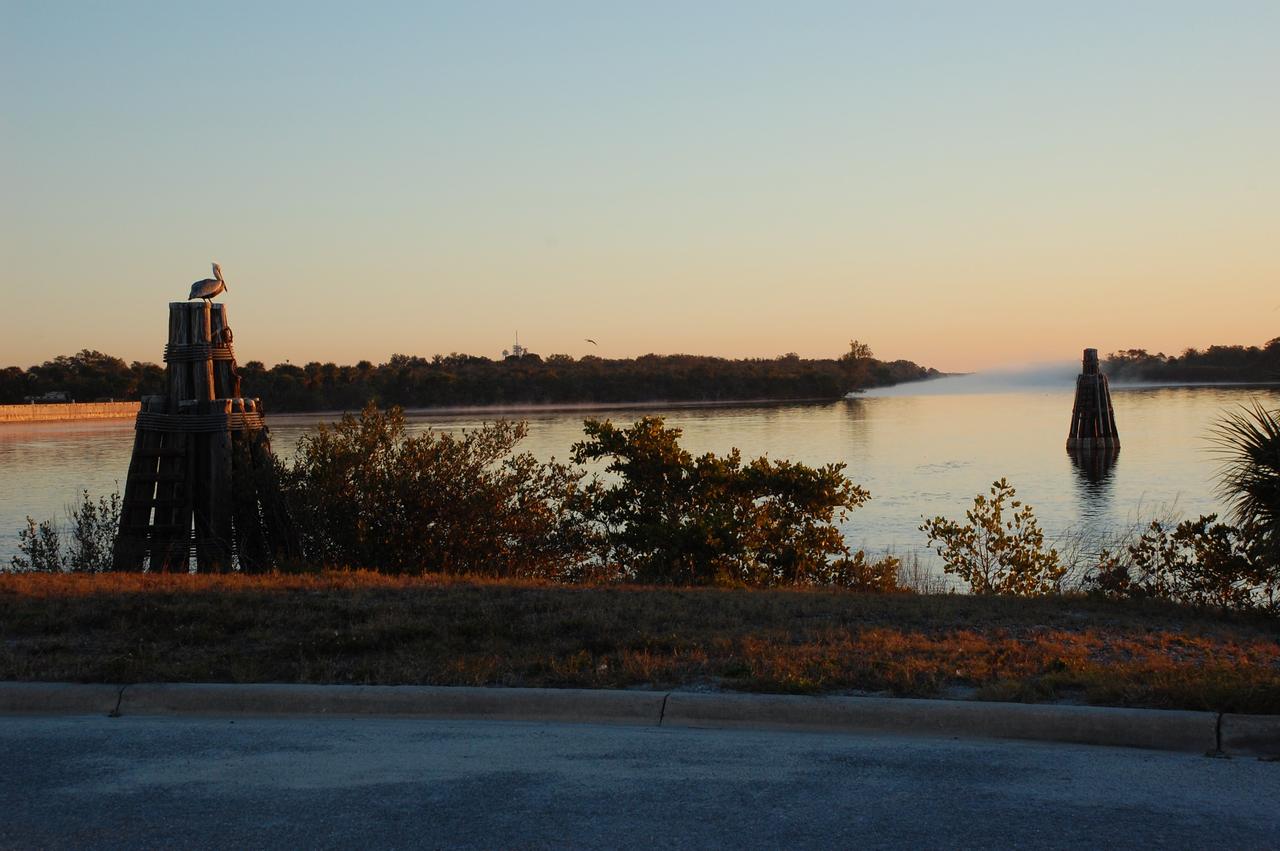
CAPE CANAVERAL, Fla. – Rising higher in the morning sky, the sun puts a glow on the fog rising from the turn basin at NASA's Kennedy Space Center in Florida. A pelican has a front row seat for the spectacle. Kennedy is surrounded by water: the Banana River, Banana Creek, Indian River Lagoon and the Atlantic Ocean, all of which provide scenes of beauty and nature that contrast with the high technology and power of the center. Photo credit: NASA/Ben Smegelsky

CAPE CANAVERAL, Fla. – The fog clears from the turn basin as the morning sky turns blue over NASA's Kennedy Space Center in Florida. A pelican has a front row seat for the spectacle. Kennedy is surrounded by water: the Banana River, Banana Creek, Indian River Lagoon and the Atlantic Ocean, all of which provide scenes of beauty and nature that contrast with the high technology and power of the center. Photo credit: NASA/Ben Smegelsky
CAPE CANAVERAL, Fla. – The sun rising over the Launch Complex 39 Area turn basin at NASA's Kennedy Space Center in Florida casts a brilliant flame in the water. At right is the U.S. flag on the grounds of the NASA News Center. Kennedy is surrounded by water: the Banana River, Banana Creek, Indian River Lagoon and the Atlantic Ocean, all of which provide scenes of beauty and nature that contrast with the high technology and power of the center. Photo credit: NASA/Ben Smegelsky
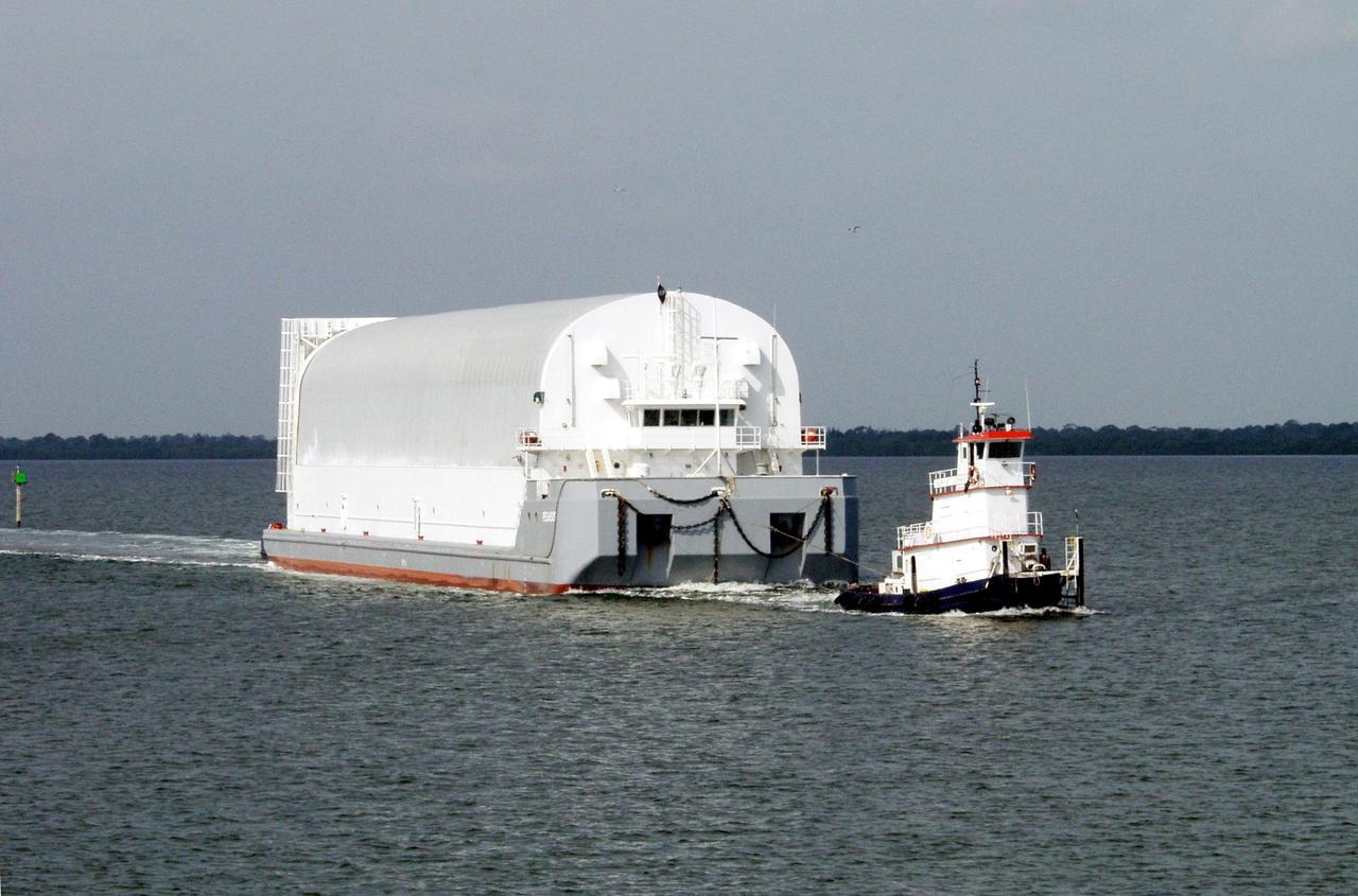
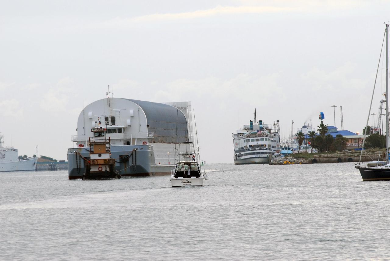
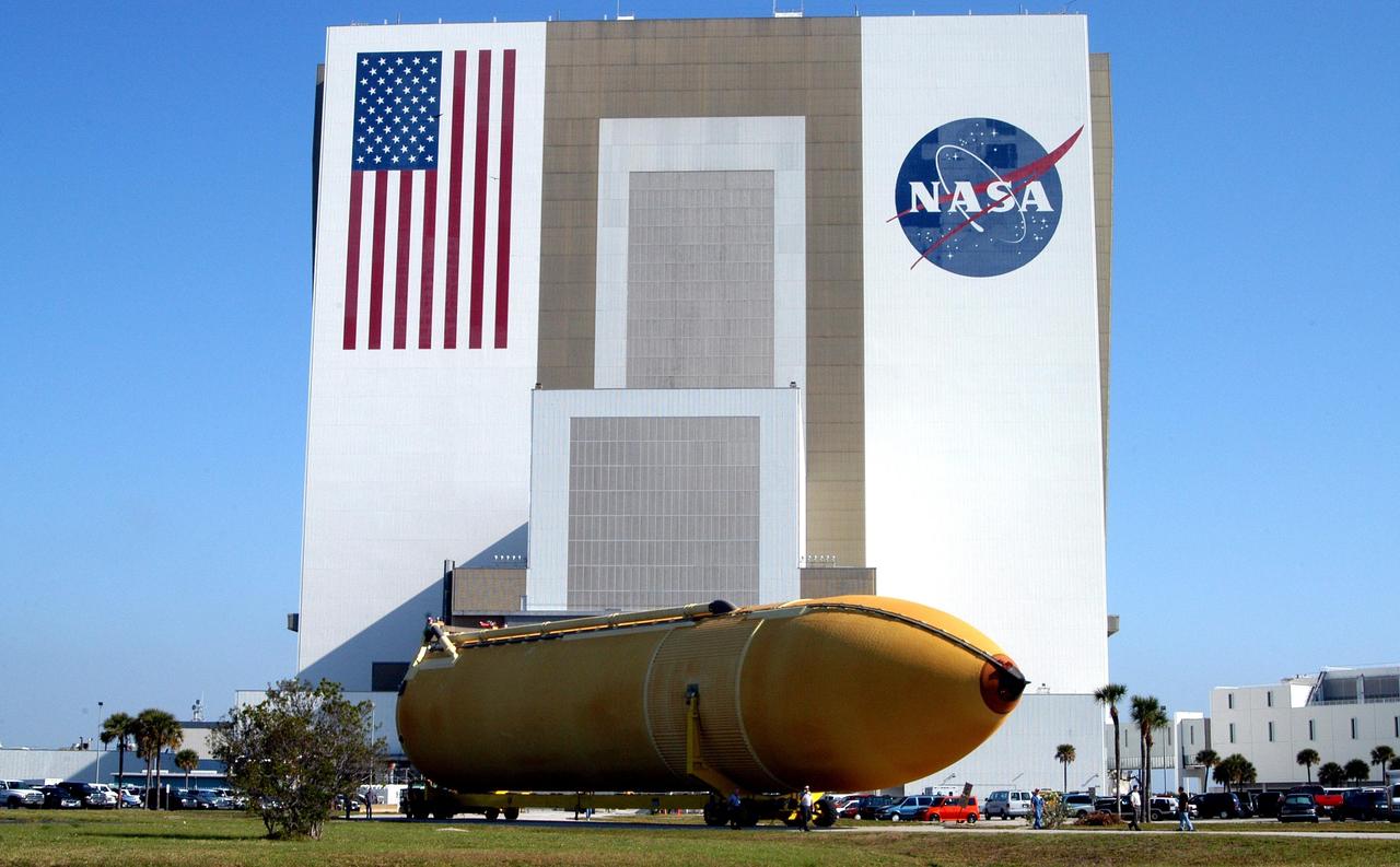
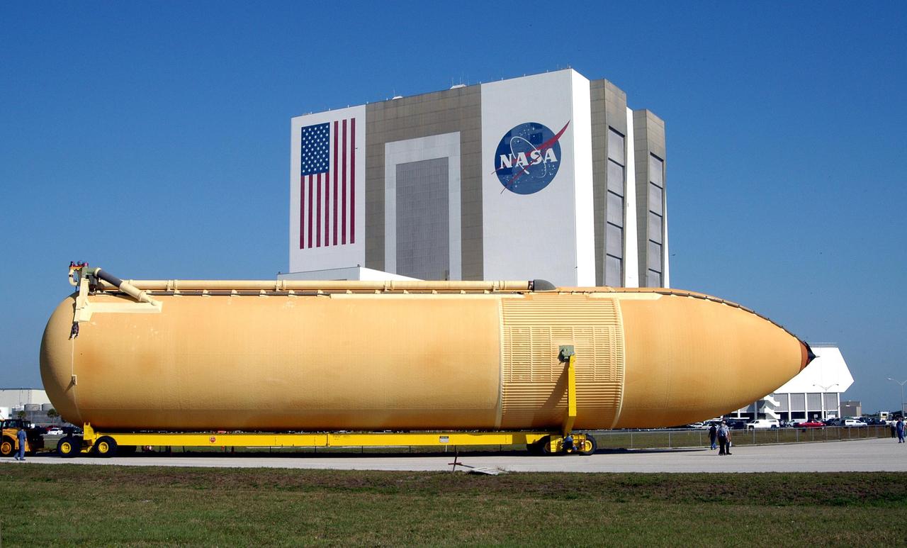
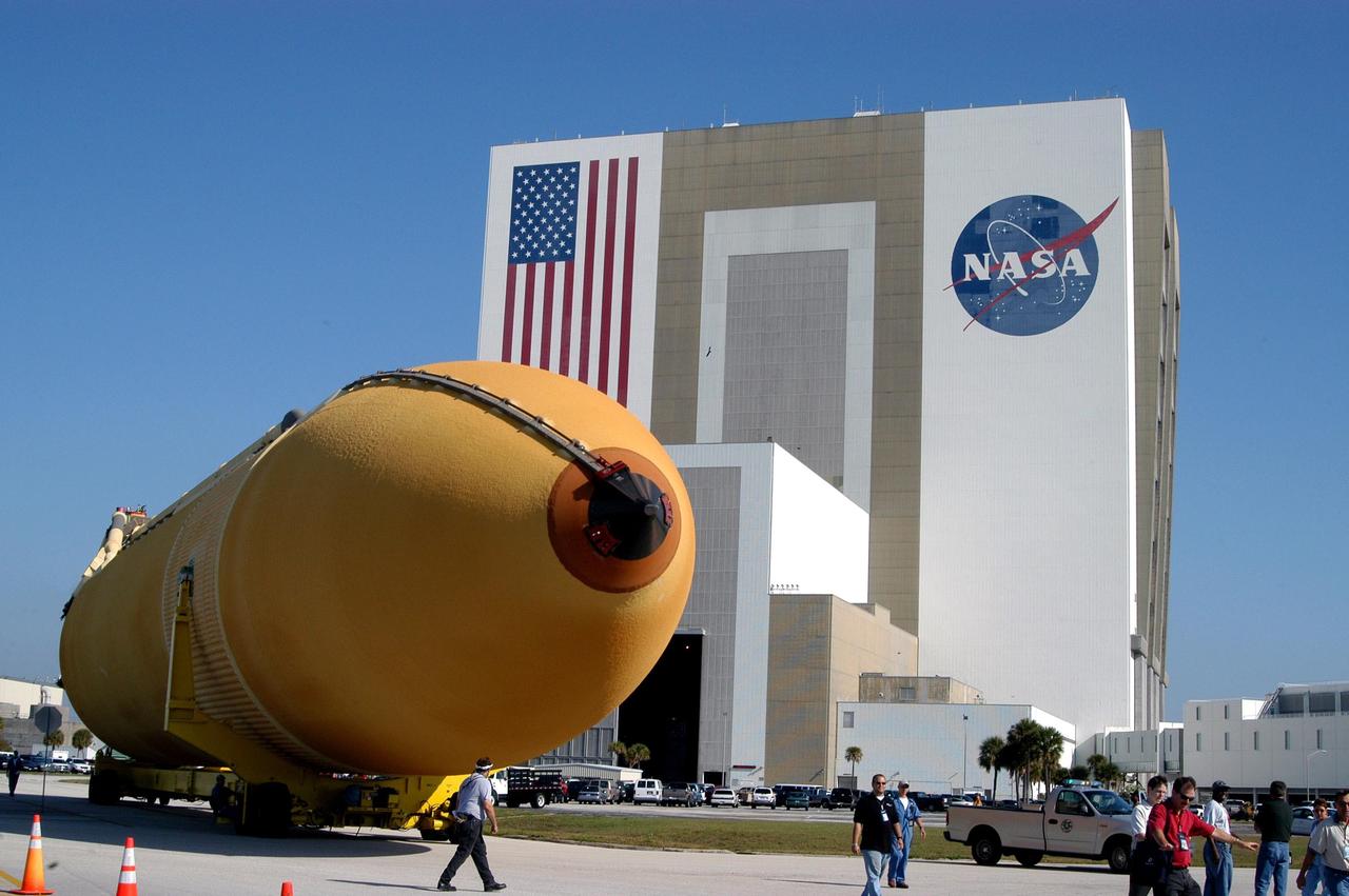
KENNEDY SPACE CENTER, FLA. -- A tug boat tows a newly arrived external tank in the Banana River to its offloading site. External tanks are built by the NASA Michoud Assembly Facility in New Orleans and transported by barge to Cape Canaveral and then up the Banana River to the turn basin in the Launch Complex 39 Area. From there it will be transported to the Vehicle Assembly Building where the tank will await stacking for a future Shuttle mission
iss074e0046046 (Jan. 5, 2025) --- The Arapey Grande River splits into its tributary, the Arapey Chico River, in northern Uruguay within the Arapey Grande Basin—a region characterized by rolling hills, natural grasslands, and dense woodlands that support a biodiverse ecosystem. The International Space Station was orbiting 268 miles above the Brazil–Uruguay border when this photograph was taken. Credit: NASA/Chris Williams
KENNEDY SPACE CENTER, FLA. -- A dolphin glides through the water looking for fish in the turn basin, which is located east of the Vehicle Assembly Building and next to the crawlerway. Dolphins inhabit the waters, known as the Indian River Lagoon, around Kennedy Space Center, along with many different species of oceanic and lagoon fish and shellfish. Mosquito Lagoon to the north, Banana River and Creek to the south and the Indian River to the west make up a special type of estuary called a lagoon, a body of water separated from the ocean by barrier islands, with limited exchange with the ocean through inlets. The Indian River Lagoon has one of the most diverse bird populations anywhere in America. Also, nearly one-third of the nation's manatee population lives here or migrates through the lagoon seasonally. The lagoon varies in width from ½ mile to 5 miles and averages only 3 feet in depth

KENNEDY SPACE CENTER, FLA. -- A dolphin glides through the water looking for fish in the turn basin, which is located east of the Vehicle Assembly Building and next to the crawlerway. Dolphins inhabit the waters, known as the Indian River Lagoon, around Kennedy Space Center, along with many different species of oceanic and lagoon fish and shellfish. Mosquito Lagoon to the north, Banana River and Creek to the south and the Indian River to the west make up a special type of estuary called a lagoon, a body of water separated from the ocean by barrier islands, with limited exchange with the ocean through inlets. The Indian River Lagoon has one of the most diverse bird populations anywhere in America. Also, nearly one-third of the nation's manatee population lives here or migrates through the lagoon seasonally. The lagoon varies in width from ½ mile to 5 miles and averages only 3 feet in depth
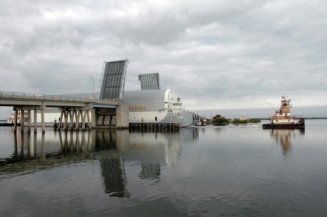
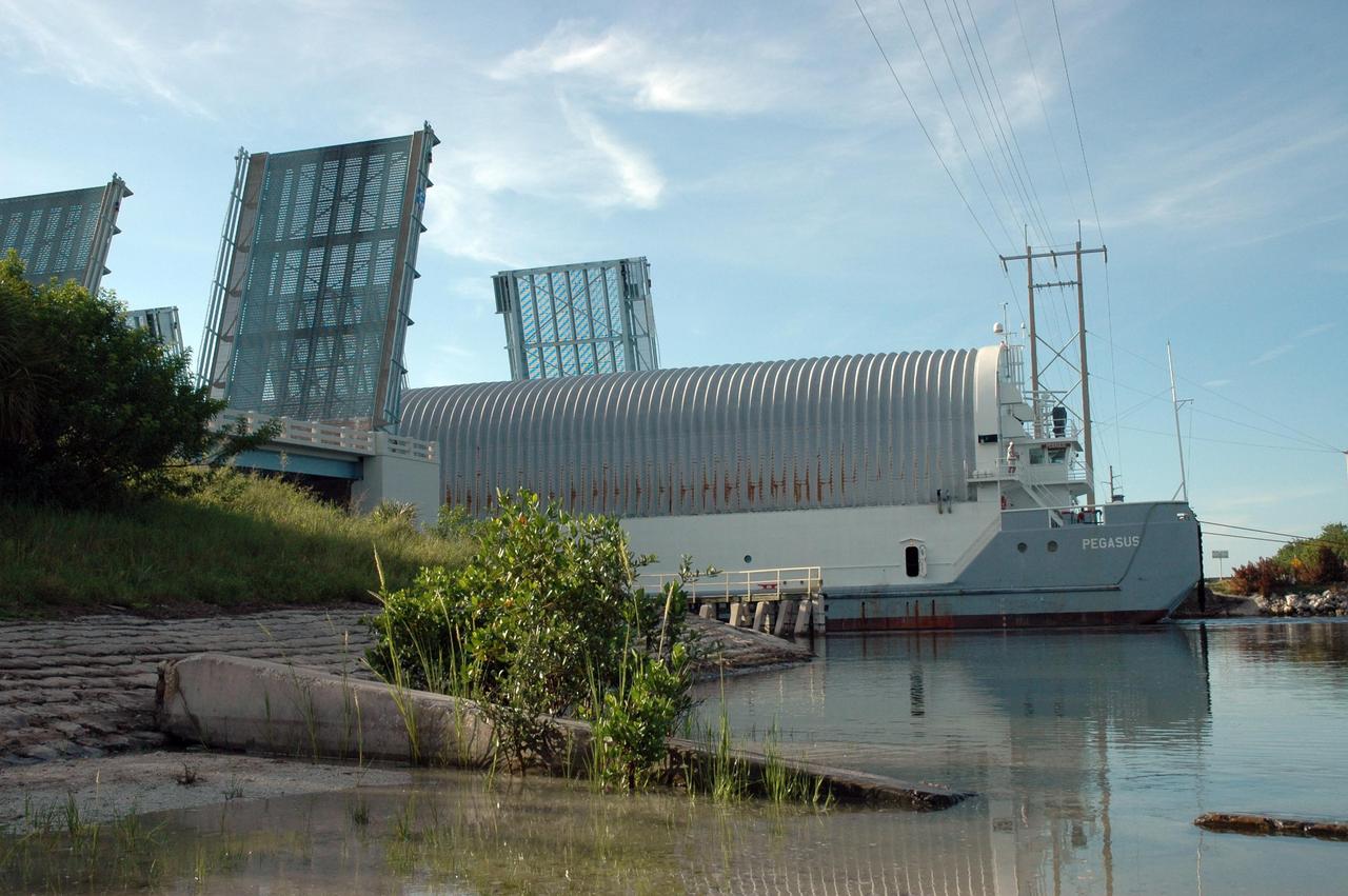
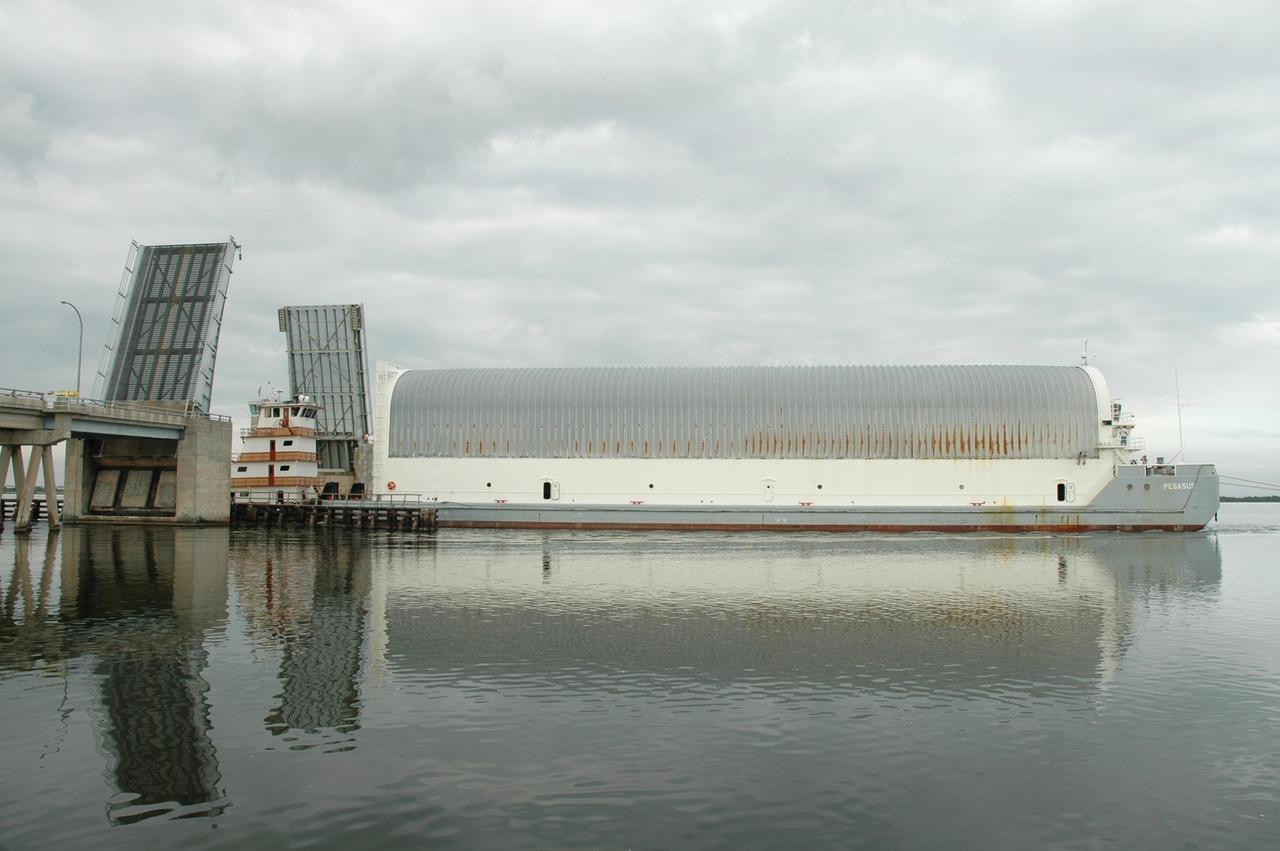
KENNEDY SPACE CENTER, FLA. -- The Pegasus barge, with its cargo of the external tank prepared for mission STS-118, moves toward the upraised Banana River bridge. The barge is being towed to the turn basin near the Vehicle Assembly Building where the tank will be offloaded and moved to the VAB. Photo credit: Jack Pfaller
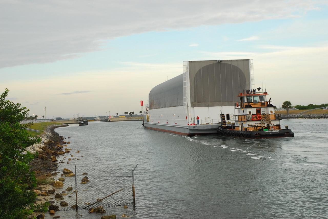
KENNEDY SPACE CENTER, FLA. -- After passing through the Banana River bridge, the Pegasus barge, with its cargo of the external tank prepared for mission STS-118, is towed upriver to the turn basin near the Vehicle Assembly Building. There the tank will be offloaded and moved to the VAB. Photo credit: Jack Pfaller
iss056e094532 (July 10, 2018) --- This portion of Bolivia's Rio Grande is about 27 miles east of downtown Santa Cruz de la Sierra, the country's largest city. The river in the Amazon Basin and the sub-tropical climate support navigation, fishing and agriculture.
iss056e094533 (July 10, 2018) --- This portion of Bolivia's Rio Grande is about 27 miles east of downtown Santa Cruz de la Sierra, the country's largest city. The river in the Amazon Basin and the sub-tropical climate support navigation, fishing and agriculture.
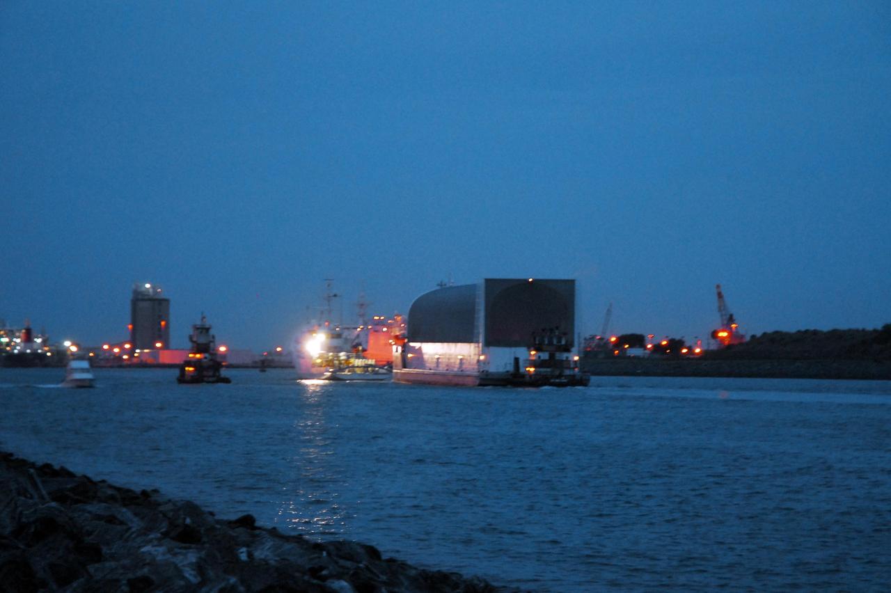
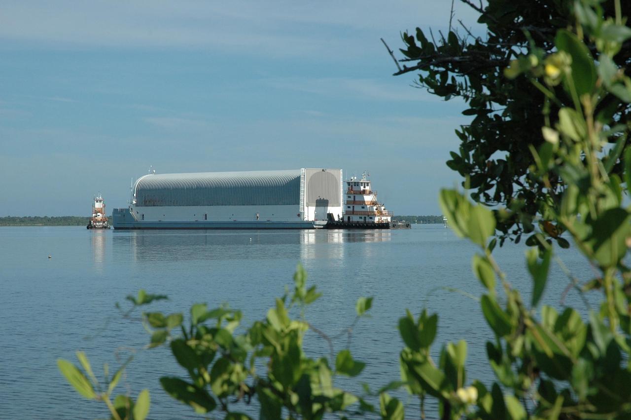
KENNEDY SPACE CENTER, FLA. -- The Pegasus barge arrives at Port Canaveral in Florida with its cargo of the external tank prepared for mission STS-118. The barge will be towed up the Banana River to the turn basin near the Vehicle Assembly Building where the tank will be offloaded and moved to the VAB. Photo credit: Jack Pfaller
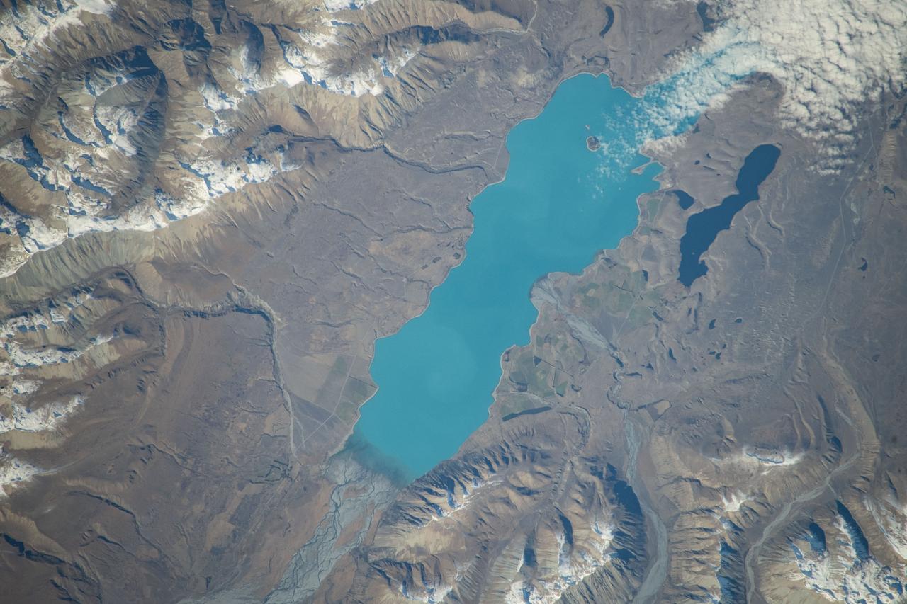
iss071e051532 (May 5, 2024) -- Lake Tekapo's turquoise color contrasts against the surrounding mountains as the International Space Station orbited 266 miles above New Zealand's South Island. Fed by the Godley River, it's one of three nearly parallel lakes in the Mackenzie Basin. Next to it lies Lake Alexandria.
iss056e094531 (July 10, 2018) --- This portion of Bolivia's Rio Grande in the Amazon Basin is about 27 miles east of downtown Santa Cruz de la Sierra, the country's largest city. The river and the region's sub-tropical climate support navigation, fishing and agriculture.
KENNEDY SPACE CENTER, FLA. -- The Pegasus barge, with its cargo of the external tank prepared for mission STS-118, moves through the upraised Banana River bridge. The barge is being towed to the turn basin near the Vehicle Assembly Building where the tank will be offloaded and moved to the VAB. Photo credit: Jack Pfaller
ISS011-E-06717 (22 May 2005) --- Uralsk, Kazakhstan is featured in this image photographed by an Expedition 11 crew member on the international space station. The rough boundary between Europe and Asia is defined by the Ural River and the Ural Mountains to its north. The Ural River flows to the great inland Caspian Sea, and gives its name to the major city of Uralsk (population approximately 250,000) on its banks. Lying just inside the Kazakh border with Russia, Uralsk is an agricultural and industrial center, and important trade stop since the early 1600s. Barge traffic has passed up and down the Ural River between the Caspian Sea and the Ural Mountains for centuries. Today it is one of the major entry points for rail traffic from Europe to Siberia, servicing the many new oil fields in the Caspian basin and the industrial cities of the southern Urals. This view shows the sunglint (light reflected from the water surface towards the observer) on the rivers, lakes and ponds of the Ural floodplain (right side of image) and that of a tributary, the Chogan River (left side of image). The cityscape of Uralsk, on the headland between the two, is relatively difficult to see because the water and sunglint dominate the scene.
ISS011-E-06712 (22 May 2005) --- Uralsk, Kazakhstan is featured in this image photographed by an Expedition 11 crew member on the international space station. The rough boundary between Europe and Asia is defined by the Ural River and the Ural Mountains to its north. The Ural River flows to the great inland Caspian Sea, and gives its name to the major city of Uralsk (population approximately 250,000) on its banks. Lying just inside the Kazakh border with Russia, Uralsk is an agricultural and industrial center, and important trade stop since the early 1600s. Barge traffic has passed up and down the Ural River between the Caspian Sea and the Ural Mountains for centuries. Today it is one of the major entry points for rail traffic from Europe to Siberia, servicing the many new oil fields in the Caspian basin and the industrial cities of the southern Urals. Numerous details are visible in the photo, including the city margin, city blocks and even the causeway and individual buildings. Part of the smaller sister city of Zashaghan can be seen on the opposite bank (bottom). The green vegetated parts of the floodplains and black inundated parts (lower left, bottom image) stand out clearly. The brown Ural River waters contrast with the darker color of its tributary, the Chogan River (lower image).

KENNEDY SPACE CENTER, FLA. -- In the turn basin east of the Vehicle Assembly Building and next to the crawlerway, a mother dolphin guides her baby through the water to search for food. Dolphins inhabit the waters around Kennedy Space Center, along with many different species of oceanic and lagoon fish and shellfish. Mosquito Lagoon to the north, Banana River and Creek to the south and the Indian River to the west make up a special type of estuary called a lagoon, a body of water separated from the ocean by barrier islands, with limited exchange with the ocean through inlets. The Indian River Lagoon has one of the most diverse bird populations anywhere in America. Also, nearly one-third of the nation's manatee population lives here or migrates through the lagoon seasonally. The lagoon varies in width from ½ mile to 5 miles and averages only 3 feet in depth

SL3-22-0214 (July-September 1973) --- A vertical view of southeastern Washington State as photographed from Earth orbit by one of the six lenses of the Itek-furnished S190-A Multispectral Photographic Facility Experiment aboard the Skylab space station. The Snake River flows into the Columbia River in the most southerly corner of the picture. The Wallula Lake is below the junction of the two rivers. The Yakima Valley is at the southwestern edge of the photograph. The Columbia Basin is in the center of the picture. The Cascade Range extends across the northwest corner of the photograph. This picture was taken with type SO-356 regular color film. The S190-A experiment is part of the Earth Resources Experiments Package. Federal agencies participating with NASA on the EREP project are the Departments of Agriculture, Commerce, Interior, the Environmental Protection Agency and the Corps of Engineers. All EREP photography is available to the public through the Department of Interior?s Earth Resources Observations Systems Data Center, Sioux Falls, South Dakota, 57198. Photo credit: NASA
KENNEDY SPACE CENTER, FLA. -- In the turn basin east of the Vehicle Assembly Building and next to the crawlerway, a mother dolphin guides her baby through the water to search for food. Dolphins inhabit the waters around Kennedy Space Center, along with many different species of oceanic and lagoon fish and shellfish. Mosquito Lagoon to the north, Banana River and Creek to the south and the Indian River to the west make up a special type of estuary called a lagoon, a body of water separated from the ocean by barrier islands, with limited exchange with the ocean through inlets. The Indian River Lagoon has one of the most diverse bird populations anywhere in America. Also, nearly one-third of the nation's manatee population lives here or migrates through the lagoon seasonally. The lagoon varies in width from ½ mile to 5 miles and averages only 3 feet in depth
STS058-91-074 (18 Oct-1 Nov 1993) --- The largest cityscape in the view is Nashville (top left), part of which is obscured under a band of clouds (the Cumberland River, on which Nashville lies, can not be seen under the cloud band). Close to the main cloud mass on the opposite side of the view, lies a small lake (Normandy Lake in sunglint (right center) 70 miles southeast of Nashville. Between these two features, in the center of the Nashville Basin, lies the city of Murfreesboro. The city appears here as a spider like pattern one third the distance from Nashville towards Normandy Lake. The Tennessee River can be seen bottom right and top right through holes in the cloud.
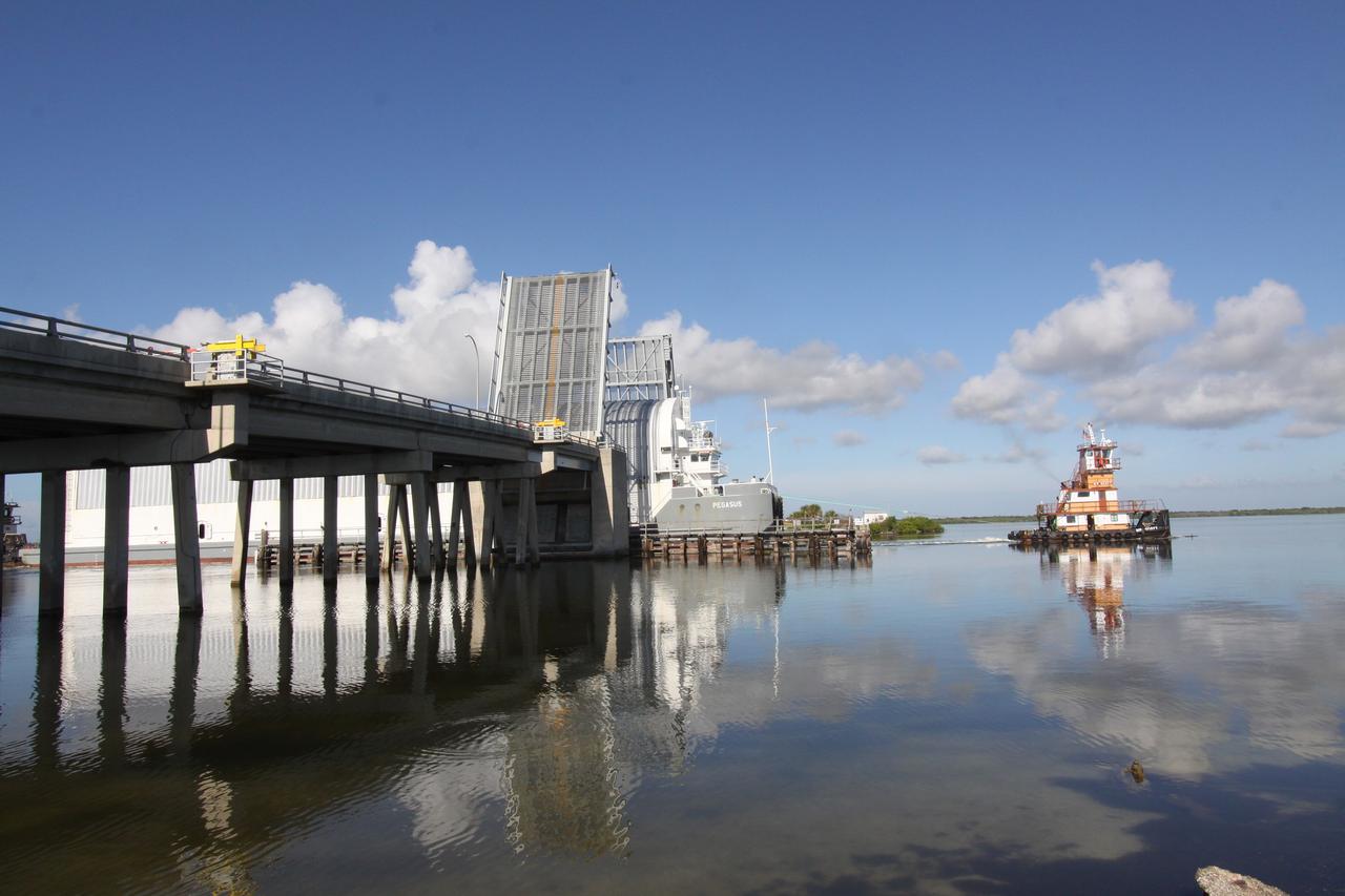
CAPE CANAVERAL, Fla. – The Pegasus barge, carrying external tank 134, passes through a bridge into the river near Port Canaveral. The tugboat will move the barge through the Banana River toward the turn basin near the Vehicle Assembly Building, or VAB, at NASA's Kennedy Space Center in Florida. Pegasus arrived in Florida after an ocean voyage towed by a solid rocket booster retrieval ship from NASA's Michoud Assembly Facility near New Orleans. After Pegasus docks in the turn basin, the fuel tank will be offloaded and transported into the VAB. ET-134 will be used to launch space shuttle Endeavour on the STS-130 mission to the International Space Station. Launch is targeted for Feb. 4, 2010. For information on the components of the space shuttle and the STS-130 mission, visit http://www.nasa.gov/shuttle. Photo credit: NASA/Jack Pfaller
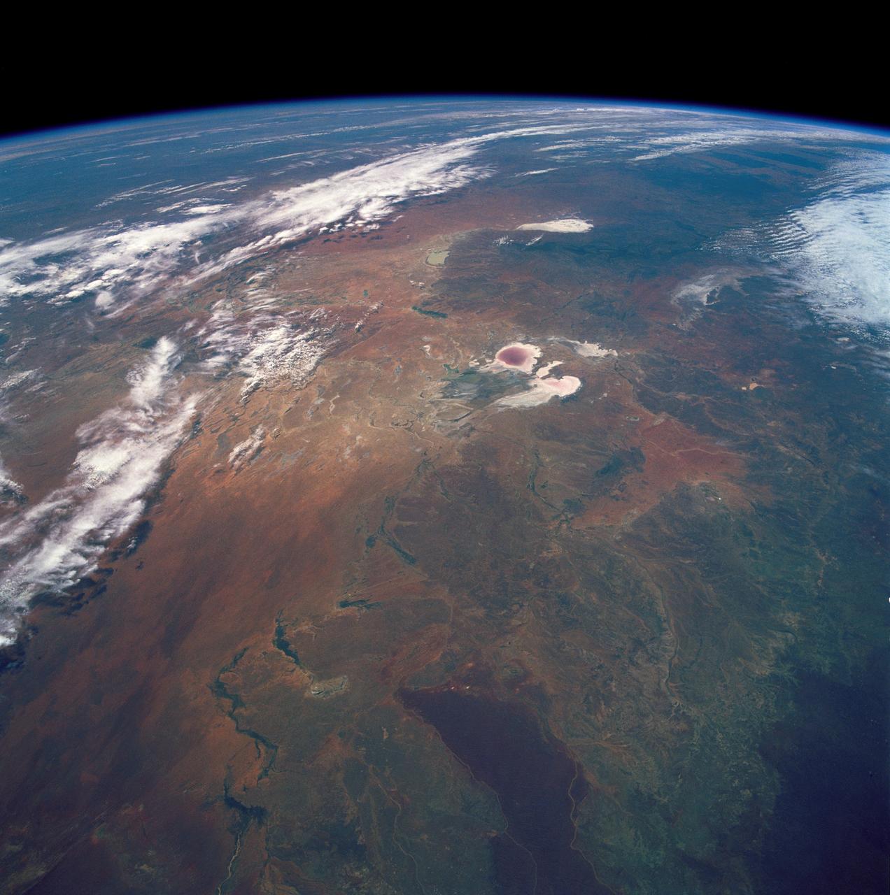
STS035-501-007 (2-10 Dec. 1990) --- The STS-35 crewmembers aboard the Earth-orbiting Space Shuttle Columbia photographed this view of the Arid Simpson Desert of Australia with a handheld Rolleiflex camera. Lake Eyre is normally dry; however, the STS-35 crew was able to recognize water in the lowest parts of the lake (dark pink area) and possibly in Lake Blanche east of Lake Eyre. Lake Frome lies in the distance separated from Lake Torrens (top right) by dark hills of Flinders Range. The Finke River (bottom left to middle) flows into the Eyre basin from the northwest. Although it is the largest river entering the basin, Finke's floods seldom reach Lake Eyre. The dark brown patch in the foreground is an area of ancient, brown lateritic soils partly covered by dunes.
View is southeastward across China (Tibet), half of Nepal and India. The partly frozen lake near the center of the frame is Pei-Ku T'so ("Bos-tie Lake"). The central Himalaya stretches from Mount Everest on the left past Annapurna on the right. Large tributaries converge to form the Ganges River, flowing through the lowland basin south of the Himalaya. This photograph illustrates the rain shadow effect of the Himalaya Chain; wet, warm air from the Indian Ocean is driven against the mountains, lifted, and drained of water that forms ice caps, the abundant rivers, and forests of the foothills. In contrast the high plateau of Tibet is arid, composed largely of topographically-closed basins because stream flow is inadequate to form integrated drainage networks.

The central portion of this image features a mildly-winding depression that was carved by water, likely around four billion years ago shortly after the Hellas basin formed following a giant asteroid or comet impact. Water would have flowed from the uplands (to the east) and drained into the low-lying basin, carving river channels as it flowed. The gentle curves-called "meanders" by geomorphologists-imply that this paleoriver carried lots of sediment along with it, depositing it into Hellas. http://photojournal.jpl.nasa.gov/catalog/PIA20815
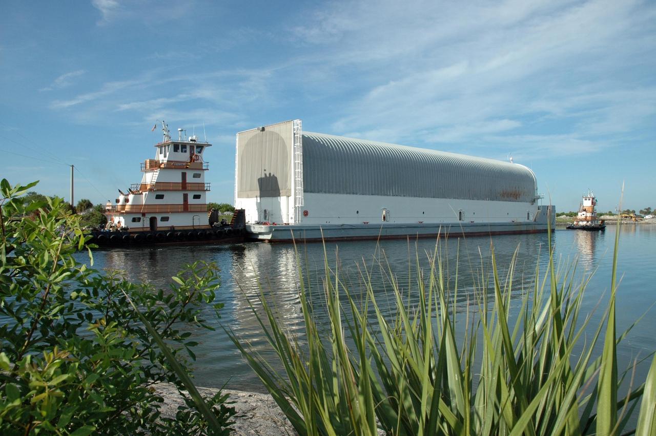
KENNEDY SPACE CENTER, FLA. -- A newly arrived external tank is transported from the turn basin to the Vehicle Assembly Building (VAB), seen behind the tank. External tanks are built by the NASA Michoud Assembly Facility in New Orleans and transported by barge to Cape Canaveral and then up the Banana River to the turn basin in the Launch Complex 39 Area. In the VAB, the tank will await stacking for a future Shuttle mission

KENNEDY SPACE CENTER, FLA. -- A newly arrived external tank heads from the turn basin toward the Vehicle Assembly Building (VAB), seen behind the tank. External tanks are built by the NASA Michoud Assembly Facility in New Orleans and transported by barge to Cape Canaveral and then up the Banana River to the turn basin in the Launch Complex 39 Area. In the VAB, the tank will await stacking for a future Shuttle mission
KENNEDY SPACE CENTER, FLA. -- A newly arrived external tank heads from the turn basin toward the Vehicle Assembly Building (VAB), seen behind the tank. External tanks are built by the NASA Michoud Assembly Facility in New Orleans and transported by barge to Cape Canaveral and then up the Banana River to the turn basin in the Launch Complex 39 Area. In the VAB, the tank will await stacking for a future Shuttle mission

KENNEDY SPACE CENTER, FLA. -- A newly arrived external tank is transported from the turn basin to the Vehicle Assembly Building (VAB), seen behind the tank. External tanks are built by the NASA Michoud Assembly Facility in New Orleans and transported by barge to Cape Canaveral and then up the Banana River to the turn basin in the Launch Complex 39 Area. In the VAB, the tank will await stacking for a future Shuttle mission
ISS005-E-12804 (6 September 2002) --- Tarbela Dam, Pakistan is featured in this image photographed by an Expedition 5 crewmember on the International Space Station (ISS). The Indus River basin extends from the Himalaya mountain ranges forming the northeastern boundary of Pakistan, to the alluvial plains of Sindh near the Arabian Sea coastline. Tarbela Dam is part of the Indus Basin Project that resulted from a water treaty signed in 1960 between India and Pakistan. This treaty guaranteed Pakistan water supplies independent of upstream control by India. Designed primarily for water storage rather than power generation, the dam was completed in 1977. Turquoise waters of the Indus River (to the south of the dam) reflect the high proportion of silt and clay suspended in waters released by the spillways (chutes on either of side of the main dam). With a volume of 142,000,000 cubic meters, the Tarbela Dam is the largest earth and rockfill dam in the world and stands 147 meters above the Indus riverbed. Its reservoir occupies an area of 37 square kilometers. While the dam has fulfilled its purpose in storing water for agricultural use in Pakistan, there have been environmental consequences to the Indus river delta, according to NASA scientists who are studying the Space Station photography. Reduction of seasonal flooding and reduced water flows to the delta have resulted in decrease of mangrove stands and abundance of some fish species.
STS083-748-066 (4-8 April 1997) --- Luxor, Qus, and Qina, Egypt on the Nile. The Nile, which is about 4,132 miles long, is the longest river in the world. This photo demonstrates the dependency of the local agriculture on the River. This area is the historic area of ancient Thebes. Luxor, also called EL-AKSUR, or AL-UQSUR, a market town along the southern part of the Nile's curve, is located on the southern half of the ruins of Thebes. Ancient Thebes was about six miles square; the main part of the city was situated along the Nile's east bank; along the west bank was "the city of the dead" -- an area containing the Egyptian kings' mortuary temples and the houses of those priests, soldiers, craftsmen, and laborers who were devoted to their service. Qina, extending 3 - 4 miles (5 - 6 kilometers) on each side of the Nile River between the Arabian and Libyan deserts, is seen on the northeast part of the rivers curve. Occupying the great bend in the Nile Valley, it has an area of 715 square miles (1,851 square kilometers) and contains the celebrated ruins of Thebes and the Valley of the Tombs of the Kings. Qina has a dense agricultural population (more than 3,000 persons per square mile), and most of its land is under basin irrigation, yielding only one crop annually. Main crops are sugar (about three-fifths of the nation's production), lentils, and grains.
![Ladon Basin was a large impact structure that was filled in by the deposits from Ladon Valles, a major ancient river on Mars as seen in this image from NASA's Mars Reconnaissance Orbiter (MRO). These wet sediments were altered into minerals such as various clay minerals. Clays imply chemistry that may have been favorable for life on ancient Mars, if anything lived there, so this could be a good spot for future exploration by rovers and perhaps return of samples to Earth. The map is projected here at a scale of 50 centimeters (19.7 inches) per pixel. [The original image scale is 52.1 centimeters (20.5 inches) per pixel (with 2 x 2 binning); objects on the order of 156 centimeters (61.4 inches) across are resolved.] North is up. https://photojournal.jpl.nasa.gov/catalog/PIA22183](https://images-assets.nasa.gov/image/PIA22183/PIA22183~medium.jpg)
Ladon Basin was a large impact structure that was filled in by the deposits from Ladon Valles, a major ancient river on Mars as seen in this image from NASA's Mars Reconnaissance Orbiter (MRO). These wet sediments were altered into minerals such as various clay minerals. Clays imply chemistry that may have been favorable for life on ancient Mars, if anything lived there, so this could be a good spot for future exploration by rovers and perhaps return of samples to Earth. The map is projected here at a scale of 50 centimeters (19.7 inches) per pixel. [The original image scale is 52.1 centimeters (20.5 inches) per pixel (with 2 x 2 binning); objects on the order of 156 centimeters (61.4 inches) across are resolved.] North is up. https://photojournal.jpl.nasa.gov/catalog/PIA22183
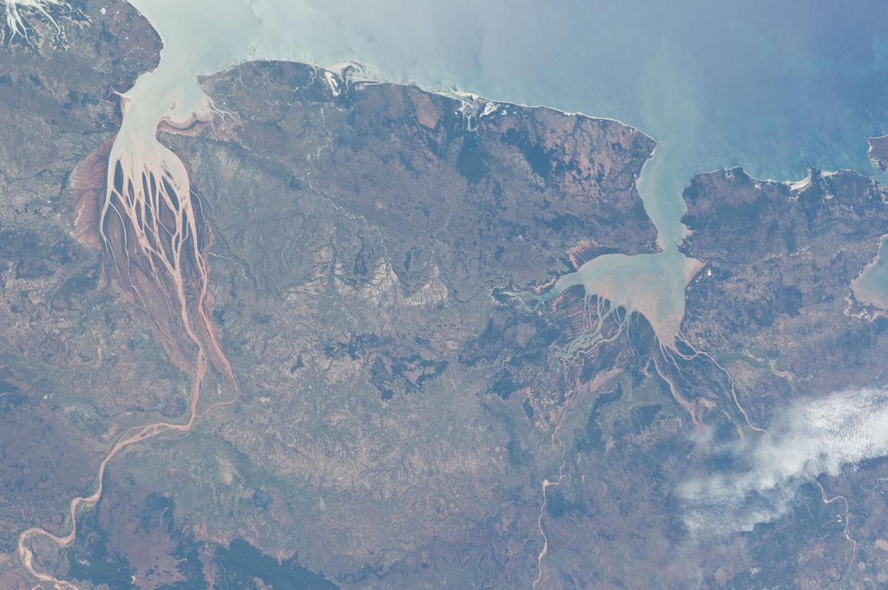
ISS028-E-006687 (2 June 2011) --- Estuaries on the northwestern coast of Madagascar are featured in this image photographed by an Expedition 28 crew member on the International Space Station. Regions where fresh water flowing in rivers and salt water from the seas and oceans mix are called estuaries, and they are among the most biologically productive ecosystems on Earth. This photograph highlights two estuaries located along the northwestern coastline of the island of Madagascar. The Mozambique Channel (top) separates Madagascar from the southeastern coast of Africa. Bombetoka Bay (upper left) is fed by the Betsiboka River and is a frequent subject of astronaut photography due to its striking red floodplain sediments. Mahajamba Bay (right) is fed by several rivers including the Mahajamba and Sofia Rivers; like the Betsiboka, the floodplains of these rivers also contain reddish sediments eroded from their basins upstream. The brackish (mix of fresh and salty water) conditions found in most estuaries host unique plant and animal species adapted to live in such environments. Mangroves in particular are a common plant species found in and around Madagascar estuaries, and Bombetoka Bay contains some of the largest remaining stands. Estuaries also host abundant fish and shellfish species ? many of which need access to freshwater for a portion of their life cycles ? and these in turn support local and migratory bird species that prey on them. However, human activities such as urban development, overfishing, and increased sediment loading from erosion of upriver highlands threaten the ecosystem health of the estuaries. In particular, the silt deposits in Bombetoka Bay at the mouth of the Betsiboka River have been filling in the bay.
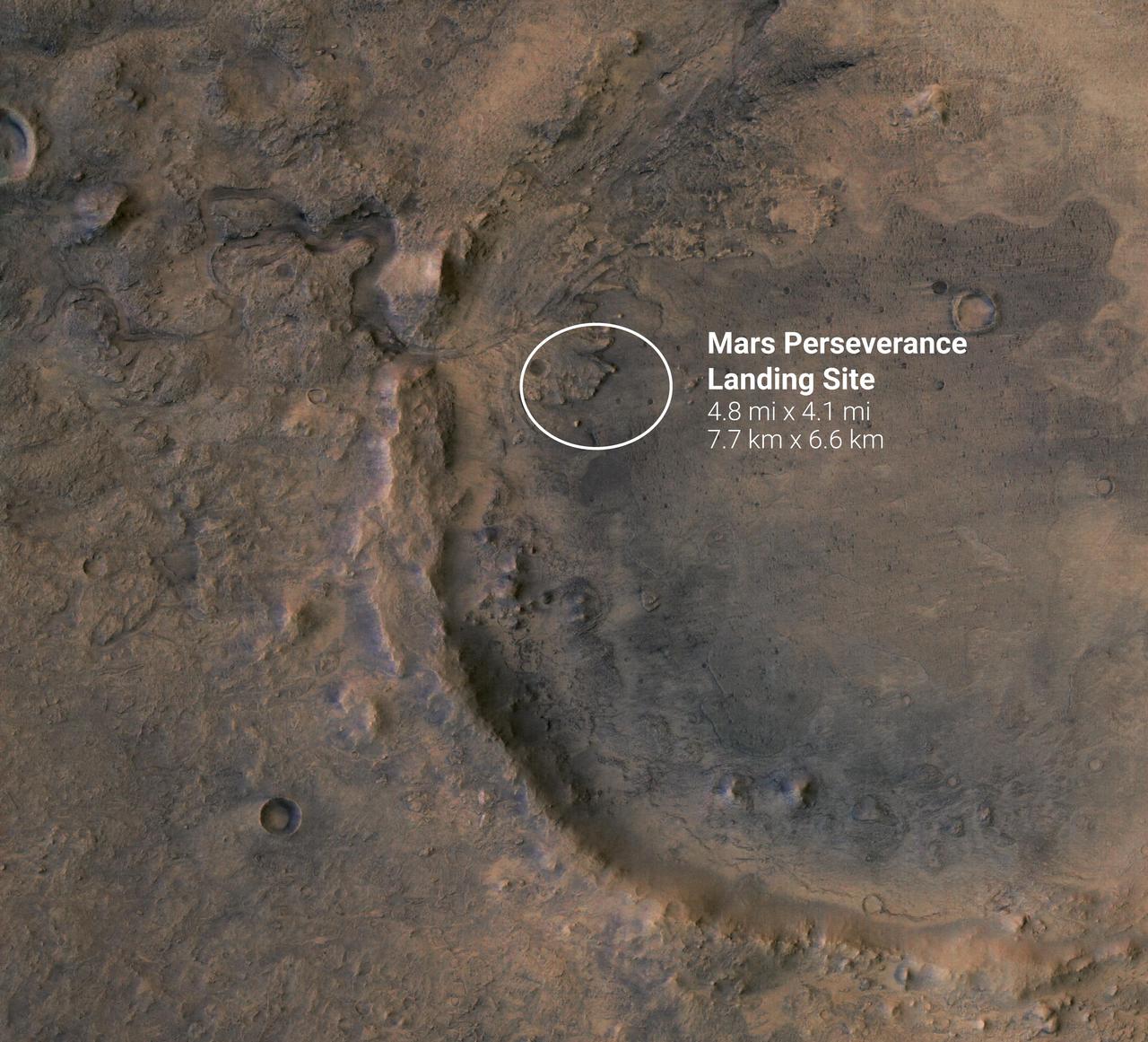
The white circle near the center of this image of Mars represents the location where NASA's Perseverance rover is expected to land on Feb. 18, 2021. The landing ellipse, measuring 4.8 miles by 4.1 miles (7.7 kilometers by 6.6 kilometers), places the rover at the site of an ancient river delta which could harbor signs of fossilized microbial life. The fan-like shape of the delta is visible in this image, as is the crater rim. The crater was once filled with a lake several hundred feet deep. Jezero Crater sits within the Isidis Planitia region of Mars, where an ancient asteroid or comet impact left behind a large basin some 750 miles (1200 kilometers) across. This event forever changed the rocks in and around the basin. A later, smaller impact created Jezero Crater within the Isidis impact basin. There is evidence of ancient river flow into Jezero, forming a lake that has long since been dry. Scientists believe that these events likely created environments friendly to life. https://photojournal.jpl.nasa.gov/catalog/PIA24350
ISS033-E-006202 (20 Sept. 2012) --- Salar de Coipasa, Bolivia is featured in this image photographed by an Expedition 33 crew member on the International Space Station. The Salar de Coipasa, located in the Altiplano region of western Bolivia, covers an area of approximately 2,500 square kilometers. The word ?salar? describes arid closed basins in which evaporation of mineral-rich waters leads to the formation of thick, flat-laying salt deposits. Salar de Coipasa is located to the southwest of the saline Lake Poopo and northwest of the largest salt flat in the world, Salar de Uyuni. At Coipasa, a crust composed of halite?common table salt?provides the brilliant white coloration characteristic of the Altiplano salars (right). While the environment of Salar de Coipasa is arid, it does receive constant water from the Lauca River flowing from the north; this feeds Lake (Lago) Coipasa that fills the northern end of the basin with shallow water (center). However, the water flow can drop off sharply during periods of drought. The waters of Lake Coipasa, and the white salt crust of the salar, also serve to highlight dark river sediments flowing into the basin along the northeastern shore. Dark volcanic rocks contrast sharply with the surrounding salt crust at right. While the western Andes Mountains contain many active volcanoes, the nearby Tata Sabaya volcano has not been historically active.
STS046-80-009 (31 July-8 Aug. 1992) --- A view of the mouth of the Amazon River and the Amazon Delta shows a large sediment plume expanding outward into the Atlantic Ocean. The sediment plume can be seen hugging the coast north of the Delta. This is caused by the west-northwest flowing Guyana Current. The large island of Marajo is partially visible through the clouds.
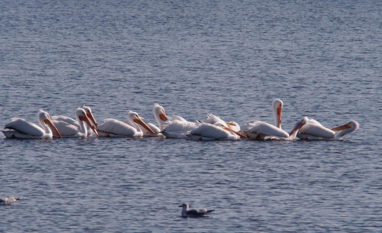
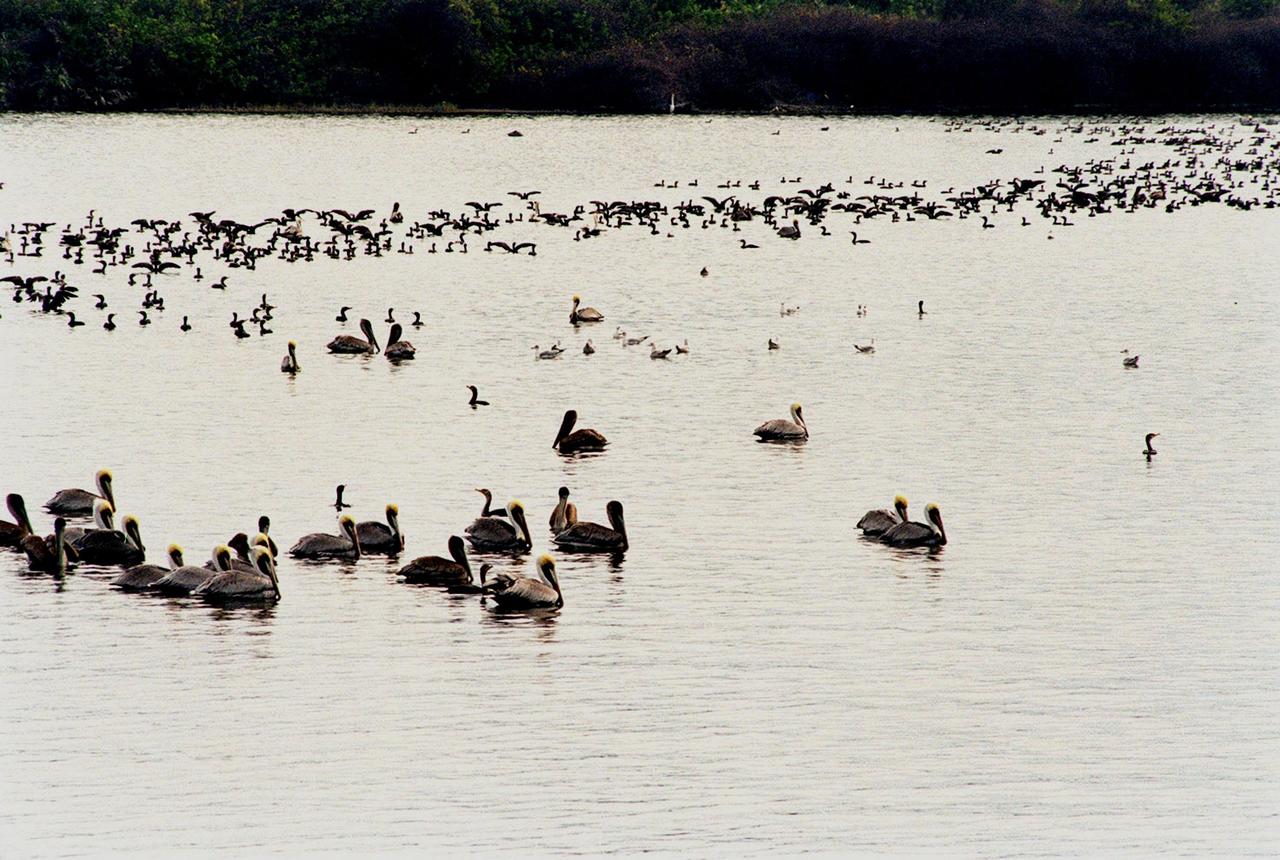
White pelicans form a line while swimming in the turn basin near the Vehicle Assembly Building of NASA's Kennedy Space Center. The turn basin was carved out of the Banana River when Kennedy Space Center was built. White pelicans winter from Florida and southern California to Panama, chiefly in coastal lagoons, and usually in colonies. KSC shares a boundary with the Merritt Island Wildlife Nature Refuge. The refuge is a habitat for more than 310 species of birds, 25 mammals, 117 fishes and 65 amphibians and reptiles. In addition, the Refuge supports 19 endangered or threatened wildlife species on Federal or State lists, more than any other single refuge in the U.S.
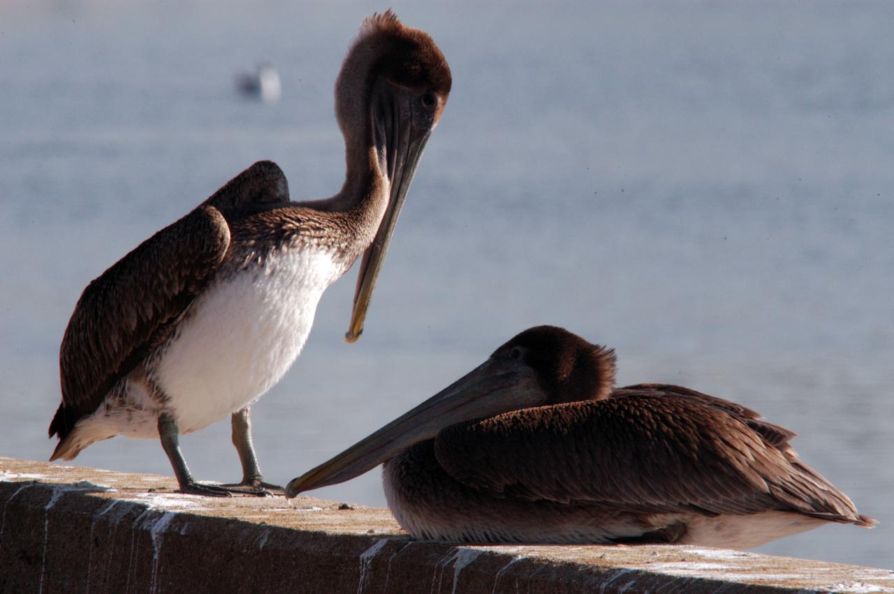
A pair of brown pelicans rest on a wall near the turn basin at NASA's Kennedy Space Center. The turn basin was carved out of the Banana River when KSC was built. The birds' habitat is sandy coastal beaches and lagoons, ranging along the Atlantic Coast from North Carolina south to Venezuela. It nests in colonies. KSC shares a boundary with the Merritt Island Wildlife Nature Refuge. The refuge is a habitat for more than 310 species of birds, 25 mammals, 117 fishes and 65 amphibians and reptiles. In addition, the Refuge supports 19 endangered or threatened wildlife species on Federal or State lists, more than any other single refuge in the U.S.
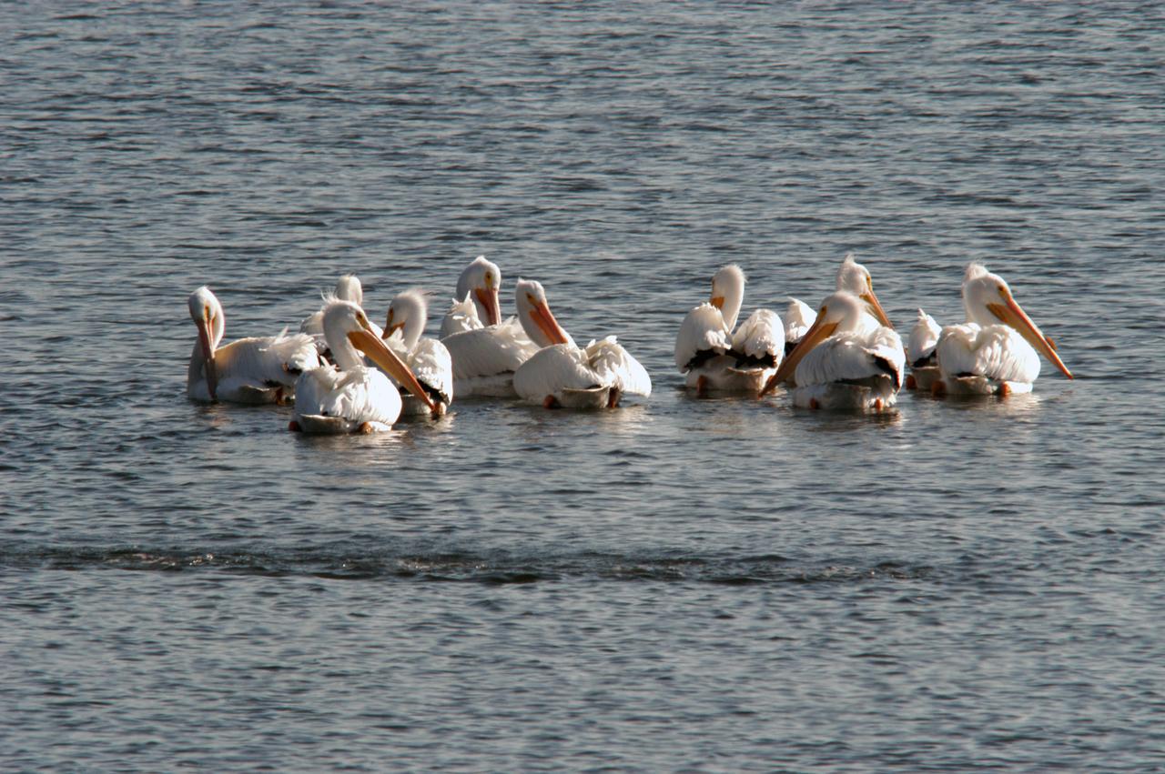
White pelicans gather in the turn basin near the Vehicle Assembly Building of NASA's Kennedy Space Center. The turn basin was carved out of the Banana River when Kennedy Space Center was built. White pelicans winter from Florida and southern California to Panama, chiefly in coastal lagoons, and usually in colonies. KSC shares a boundary with the Merritt Island Wildlife Nature Refuge. The refuge is a habitat for more than 310 species of birds, 25 mammals, 117 fishes and 65 amphibians and reptiles. In addition, the Refuge supports 19 endangered or threatened wildlife species on Federal or State lists, more than any other single refuge in the U.S.
S73-34295 (June 1973) --- A vertical view of a portion of northern California reproduced from data taken from the Skylab Multispectral Scanner, experiment S192, in the Skylab space station in Earth orbit. This view is the most westerly one-third of Frame No. 001, Roll No. 518, S192, Skylab 2. Frame No. 001 extends from the Pacific coast at the Eureka area southeasterly 175 nautical miles to the Feather River drainage basin. Included in this view are Eureka, Trinidad, Klamath & Trinity Rivers and the Coastal Range mountains. This non-photographic image is a color composite of channels 2 (visible), 7, and 12 (infrared) from the Earth Resources Experiments Package (EREP) S192 scanner. The scanner techniques assist with spectral signature identification and mapping of ground truth targets in agriculture, forestry, geology, hydrology and oceanography. Photo credit: NASA
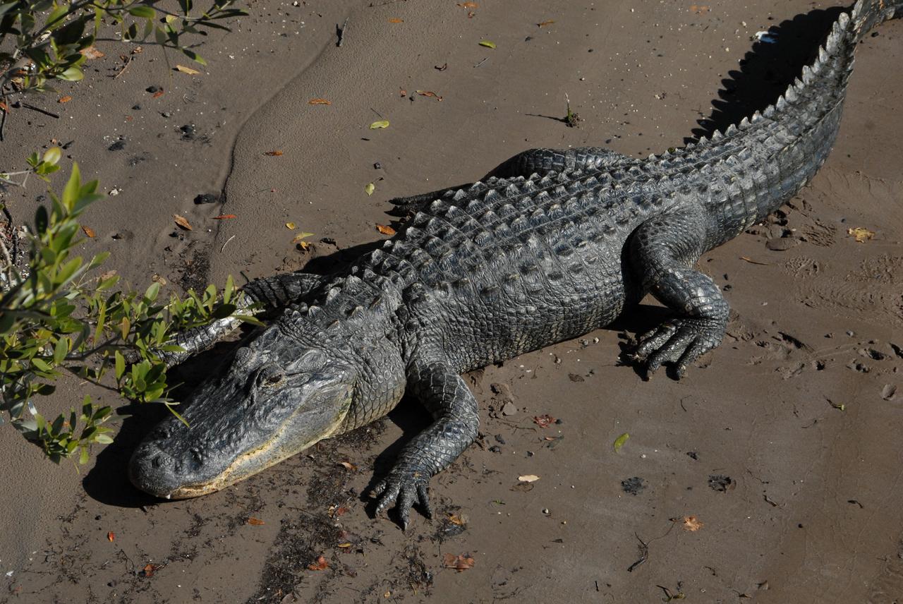
CAPE CANAVERAL, Fla. -- An alligator basks in the sun on the bank of the Banana River near NASA's Kennedy Space Center in Florida. It is witness to the passage of the Pegasus barge through the Banana River toward the turn basin near the Vehicle Assembly Building, or VAB, at NASA's Kennedy Space Center in Florida. Pegasus, carrying external tank 130, arrived in Florida after an ocean voyage towed by a solid rocket booster retrieval ship from NASA's Michoud Assembly Facility near New Orleans. After the Pegasus docks, the fuel tank will be offloaded and transported to the VAB. External tank 130 is the one designated for space shuttle Endeavour on the STS-127 mission targeted for launch on May 15. Photo credit: NASA/Troy Cryder
S73-34295A (June 1973) --- A vertical view of a portion of northern California reproduced from data taken from the Skylab Multispectral Scanner, experiment S192, in the Skylab space station in Earth orbit. This view is the most westerly one-third of Frame No. 001, Roll No. 518, S192, Skylab 2. Frame No. 001 extends from the Pacific coast at the Eureka area southeasterly 175 nautical miles to the Feather River drainage basin. Included in this view are Sacramento River Valley, Oroville Reservoir, Oroville and Chico. This non-photographic image is a color composite of channels 2 (visible), 7 and 12 (infrared) from the Earth Resources Experiments Package (EREP) S192 scanner. The scanner techniques assist with spectral signature identification and mapping of ground truth targets in agriculture, forestry, geology, hydrology and oceanography. Photo credit: NASA
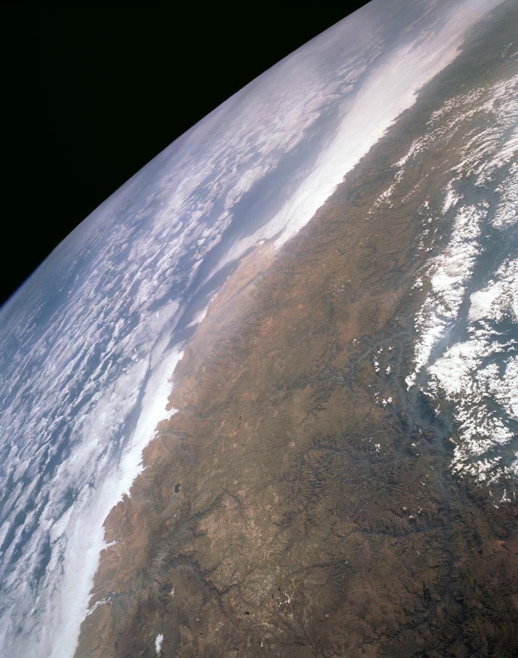
STS043-151-159 (2-11 August 1991) --- This photograph looks westward over the high plateau of the southern Peruvian Andes west and north of Lake Titicaca (not in field of view). Lima, Peru lies under the clouds just north of the clear coastal area. Because the high Andes have been uplifted 10,000 to 13,000 feet during the past 20 million years, the rivers which cut down to the Pacific Ocean have gorges almost that deep, such as the Rio Ocona at the bottom of the photograph. The eastern slopes of the Andes are heavily forested, forming the headwaters of the Amazon system. Smoke from burning in the Amazon basin fills river valleys on the right side of the photograph. A Linhof camera was used to take this view.
KENNEDY SPACE CENTER, FLA. -- In the turn basin east of the Vehicle Assembly Building and next to the crawlerway, a mother dolphin guides her baby through the water to search for food. Dolphins inhabit the waters around Kennedy Space Center, along with many different species of oceanic and lagoon fish and shellfish. Mosquito Lagoon to the north, Banana River and Creek to the south and the Indian River to the west make up a special type of estuary called a lagoon, a body of water separated from the ocean by barrier islands, with limited exchange with the ocean through inlets. The Lagoon varies in width from ½ mile to 5 miles and averages only 3 feet in depth. Nearly one-third of the nation's manatee population lives here or migrates through the Lagoon seasonally
S73-34295B (June 1973) --- A vertical view of a portion of northern California reproduced from data taken from the Skylab Multispectral Scanner, experiment S192, in the Skylab space station in Earth orbit. This view is the most westerly one-third of Frame No. 001, Roll No. 518, S192, Skylab 2. Frame No. 001 extends from the Pacific coast at the Eureka area southeasterly 175 nautical miles to the Feather River drainage basin. Included in this view are Lake Shasta, Sacramento River Valley, Redding and Red Bluff. This non-photographic image is a color composite of channels 2 (visible), 7, and 12 (infrared) from the Earth Resources Experiments Package (EREP) S192 scanner. The scanner techniques assist with spectral signature identification and mapping of ground truth targets in agriculture, forestry, geology, hydrology and oceanography. Photo credit: NASA

KENNEDY SPACE CENTER, FLA. -- In the turn basin east of the Vehicle Assembly Building and next to the crawlerway, a mother dolphin guides her baby through the water to search for food. Next to them on a rock is an osprey eating a fish. Dolphins inhabit the waters around Kennedy Space Center, along with many different species of oceanic and lagoon fish and shellfish. Mosquito Lagoon to the north, Banana River and Creek to the south and the Indian River to the west make up a special type of estuary called a lagoon, a body of water separated from the ocean by barrier islands, with limited exchange with the ocean through inlets. The Lagoon varies in width from ½ mile to 5 miles and averages only 3 feet in depth. Nearly one-third of the nation's manatee population lives here or migrates through the Lagoon seasonally. The lagoon also has one of the most diverse bird populations anywhere in America
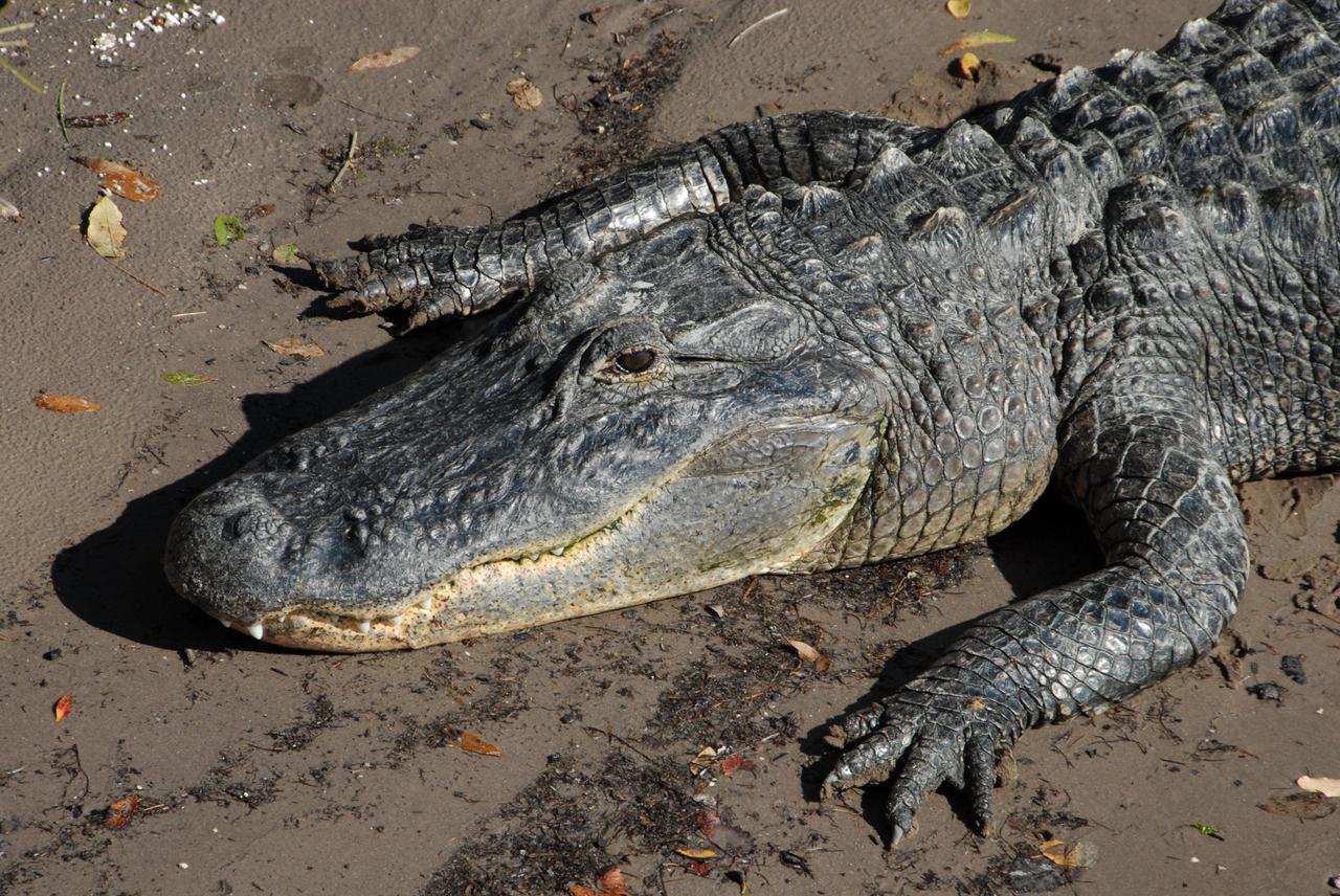
CAPE CANAVERAL, Fla. -- An alligator basks in the sun on the bank of the Banana River near NASA's Kennedy Space Center in Florida. It is witness to the passage of the Pegasus barge through the Banana River toward the turn basin near the Vehicle Assembly Building, or VAB, at NASA's Kennedy Space Center in Florida. Pegasus, carrying external tank 130, arrived in Florida after an ocean voyage towed by a solid rocket booster retrieval ship from NASA's Michoud Assembly Facility near New Orleans. After the Pegasus docks, the fuel tank will be offloaded and transported to the VAB. External tank 130 is the one designated for space shuttle Endeavour on the STS-127 mission targeted for launch on May 15. Photo credit: NASA/Troy Cryder
KENNEDY SPACE CENTER, FLA. -- In the turn basin east of the Vehicle Assembly Building and next to the crawlerway, a mother dolphin guides her baby through the water to search for food. Next to them on a rock is an osprey eating a fish. Dolphins inhabit the waters around Kennedy Space Center, along with many different species of oceanic and lagoon fish and shellfish. Mosquito Lagoon to the north, Banana River and Creek to the south and the Indian River to the west make up a special type of estuary called a lagoon, a body of water separated from the ocean by barrier islands, with limited exchange with the ocean through inlets. The Lagoon varies in width from ½ mile to 5 miles and averages only 3 feet in depth. Nearly one-third of the nation's manatee population lives here or migrates through the Lagoon seasonally. The lagoon also has one of the most diverse bird populations anywhere in America

KENNEDY SPACE CENTER, FLA. -- In the turn basin east of the Vehicle Assembly Building and next to the crawlerway, a mother dolphin guides her baby through the water to search for food. Dolphins inhabit the waters around Kennedy Space Center, along with many different species of oceanic and lagoon fish and shellfish. Mosquito Lagoon to the north, Banana River and Creek to the south and the Indian River to the west make up a special type of estuary called a lagoon, a body of water separated from the ocean by barrier islands, with limited exchange with the ocean through inlets. The Lagoon varies in width from ½ mile to 5 miles and averages only 3 feet in depth. Nearly one-third of the nation's manatee population lives here or migrates through the Lagoon seasonally

This view of deforestation in Rondonia, far western Brazil, (10.0S, 63.0W) is part of an agricultural resettlement project which ultimately covers an area about 80% the size of France. The patterns of deforestation in this part of the Amazon River Basin are usually aligned adjacent to highways, secondary roads, and streams for ease of access and transportation. Compare this view with the earlier 51G-37-062 for a comparison of deforestation in the region.
KENNEDY SPACE CENTER, FLA. -- Towed by a tugboat, the Pegasus barge passes through the open bridge in the Banana River on its way to the turn basin in the Launch Complex 39 Area at NASA's Kennedy Space Center. The barge is carrying the external tank for space shuttle Endeavour's STS-123 mission. After offloading, the tank will be transported to the Vehicle Assembly Building. Endeavour is targeted for launch to the International Space Station on Feb. 14. Photo credit: NASA/Jim Grossmann
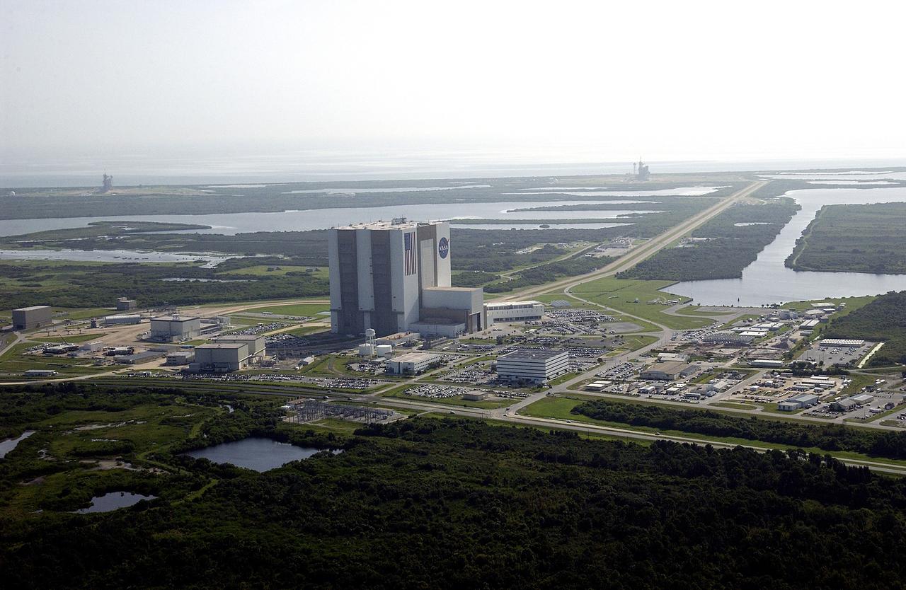
CAPE CANAVERAL, Fla. -- This aerial view shows the Launch Complex 39 Area. At center is the 525-foot-tall Vehicle Assembly Building. On the horizon at the far left is Launch Pad 39B to the right is Launch Pad 39A. The crawlerway can be seen stretching from the VAB toward Pad A. Waters of the Banana Creek and Banana River surround the pads. At center right is the Turn Basin. Photo credit: NASA
KENNEDY SPACE CENTER, FLA. -- Tugboats tow the Pegasus barge, with its cargo of external tank No. 125, on the Banana River. The barge is being towed to the turn basin in the Launch Complex 39 Area where the external tank will be offloaded and moved to the Vehicle Assembly Building. The external tank will be used on space shuttle Atlantis for mission STS-122 targeted for launch on Dec. 6. Photo credit: NASA/Troy Cryder
KENNEDY SPACE CENTER, FLA. - Atop a transporter, the external tank seen here turns the corner from the Vehicle Assembly Building toward the Turn Basin and the Banana River. The tank will be loaded onto the waiting barge and transferred to the Michoud Space Systems Assembly Facility near New Orleans where redesign of the external tank is underway for Return to Flight.
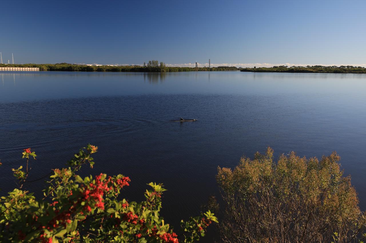
A dolphin swims in the turn basin of Launch Complex 39 at NASA’s Kennedy Space Center in Florida on Tuesday, Nov. 26, 2024. A SpaceX Falcon 9 rocket also can be seen in the background at Launch Pad 39A. Dolphins are a frequent sight in the rivers around NASA Kennedy, which shares a boundary with the Merritt Island Wildlife National Refuge and more than 1,500 species of plants and animals on 140,000 acres.
KENNEDY SPACE CENTER, FLA. - After leaving the Vehicle Assembly Building, the external tank seen here points its way toward the Turn Basin and the Banana River. The tank will be loaded onto the waiting barge and transferred to the Michoud Space Systems Assembly Facility near New Orleans where redesign of the external tank is underway for Return to Flight.
KENNEDY SPACE CENTER, FLA. -- The Pegasus barge passes through the haulover canal on the Banana River with its cargo of external tank No. 125. The barge is being towed to the turn basin in the Launch Complex 39 Area where the external tank will be offloaded and moved to the Vehicle Assembly Building. The external tank will be used on space shuttle Atlantis for mission STS-122 targeted for launch on Dec. 6. Photo credit: NASA/Troy Cryder
KENNEDY SPACE CENTER, FLA. -- Towed by a tugboat, the Pegasus barge passes through the open bridge in the Banana River on its way to the turn basin in the Launch Complex 39 Area at NASA's Kennedy Space Center. The barge is carrying the external tank for space shuttle Endeavour's STS-123 mission. After offloading, the tank will be transported to the Vehicle Assembly Building. Endeavour is targeted for launch to the International Space Station on Feb. 14. Photo credit: NASA/Jim Grossmann
KENNEDY SPACE CENTER, FLA. -- Tugboats guide the Pegasus barge carrying external tank No. 125 in the Banana River after the barge's long journey around the Florida Peninsula from the Michoud Assembly Facility near New Orleans. The barge is being towed to the turn basin in the Launch Complex 39 Area where the external tank will be offloaded and moved to the Vehicle Assembly Building. The external tank will be used on space shuttle Atlantis for mission STS-122 targeted for launch on Dec. 6. Photo credit: NASA/Troy Cryder
STS058-74-000R (18 Oct-1 Nov 1993) --- A broad view westward along the Colorado River from just below Glen Canyon Dam (out of picture), through the entire Grand Canyon to Lake Mead and Las Vegas, and westward to include southern Nevada and much of California. The Salton Sea, Los Angeles Basin, and Great Valley rim the Pacific Coast in the distance. Photo credit: NASA
Filled with briny lakes, the Quisquiro salt flat in South America's Altiplano represents the kind of landscape that scientists think may have existed in Gale Crater, which NASA's Curiosity rover is exploring. This salt flat is located in Chile, though the Altiplano sprawls across countries. Streams and rivers flowing from mountain ranges into this arid, high-altitude plateau lead to closed basins similar to Mars' ancient Gale Crater. Lakes on the Altiplano are heavily influenced by climate in the same way as Gale. https://photojournal.jpl.nasa.gov/catalog/PIA23374

KENNEDY SPACE CENTER, FLA. – This aerial view shows Launch Complex 39 Area. At center is the 525-foot-tall Vehicle Assembly Building. On the horizon at the far left is Launch Pad 39B; to the right is Launch Pad 39A. The crawlerway can be seen stretching from the VAB toward Pad A. Waters of the Banana Creek and Banana River surround the pads. At center right is the Turn Basin.
KENNEDY SPACE CENTER, FLA. - With employees walking alongside, the external tank atop its transporter turns the corner from the Vehicle Assembly Building toward the Turn Basin and the Banana River. The tank will be loaded onto the waiting barge and transferred to the Michoud Space Systems Assembly Facility near New Orleans where redesign of the external tank is underway for Return to Flight.
The oval shaped basin of the sedimentary rocks of the Hammersley Range, northern Western Australia (23.0S, 119.0E) dominates the center of this near nadir view. The Fortescue River is the remarkably straight, fault controlled feature bordering the Hammersley on the north. Sand dunes are the main surface features in the northeast and southwest. Many dry lakebeds can be seen to the east as light grey colored patches along the watercourses.
STS040-614-061 (5-14 June 1991) --- Albuquerque, New Mexico is perched on the edge of the Rio Grande floodplain, which crosses the photograph from upper left to center lower right. The reddish-brown surface of the Albuquerque Basin, a fault-bounded structural basin filled by alluvial fan and lake-bed sediments, is broken by an irregular light-toned rim River along both the Rio Grande and Rio Puerco (lower left). The rim marks the erosional edge of an ancient caliche soil that formed more than a half-million years ago, before the Rio Grande integrated its drainage from basin to basin. The upper right portion of the photograph is dominated by dark tones, representing pinyon/juniper and other timber growing on very old rocks of the Sandia Mountains. Interstate 40 can be seen passing through Sandia Pass which cuts the mountain mass.
KENNEDY SPACE CENTER, FLA. -- A dolphin silently glides through the water of the turn basin near the Vehicle Assembly Building of NASA's Kennedy Space Center. The turn basin was carved out of the Banana River when Kennedy Space Center was built. Dolphins frequent bays and coastlines, usually in depths under 20 meters. While some pods take up permanent residence and establish home waters, others are migratory and swim considerable distances from coast to coast. Dolphins are a frequent sight in the rivers around KSC, which shares a boundary with the Merritt Island Wildlife Nature Refuge. KSC shares a boundary with the Merritt Island Wildlife Nature Refuge. The refuge is a habitat for more than 310 species of birds, 25 mammals, 117 fishes and 65 amphibians and reptiles. In addition, the Refuge supports 19 endangered or threatened wildlife species on Federal or State lists, more than any other single refuge in the U.S. Photo credit: NASA/Jim Grossmann