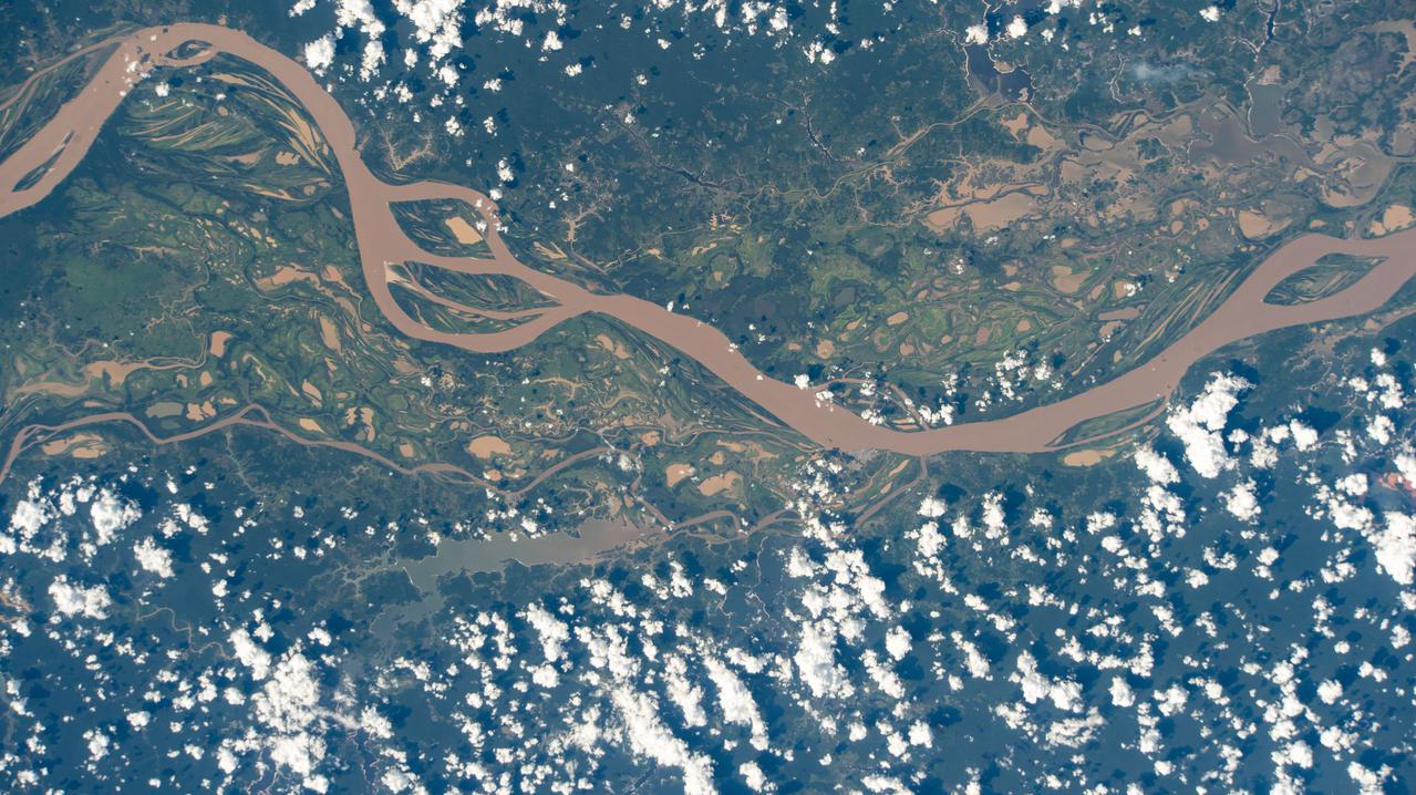
This view shows the confluence of the Amazon and the Topajos Rivers at Santarem, Brazil (2.0S, 55.0W). The Am,azon flows from lower left to upper right of the photo. Below the river juncture of the Amazon and Tapajos, there is considerable deforestation activity along the Trans-Amazon Highway.
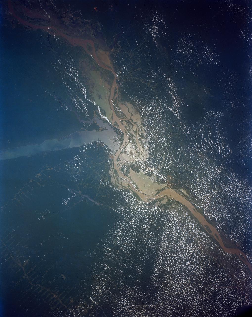
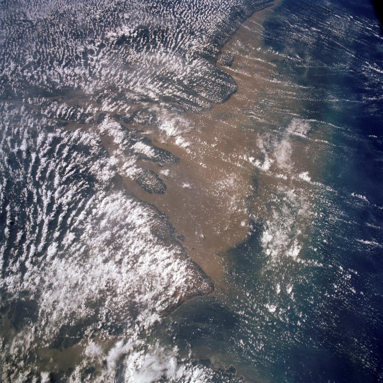
Huge sediment loads from the interior of the country flow through the Mouths of the Amazon River, Brazil (0.5S, 50.0W). The river current carries hundreds of tons of sediment through the multiple outlets of the great river over 100 miles from shore before it is carried northward by oceanic currents. The characteristic "fair weather cumulus" pattern of low clouds over the land but not over water may be observed in this scene.
iss072e311451 (Dec. 3, 2024) --- The Sun's glint beams off one of the many rivers that snake throughout South America's fertile, low grasslands region, also known as the Pampas. The International Space Station was orbiting 261 miles above the border of Paraguay and Argentina at the time of this photograph. Credit: NASA/Don Pettit
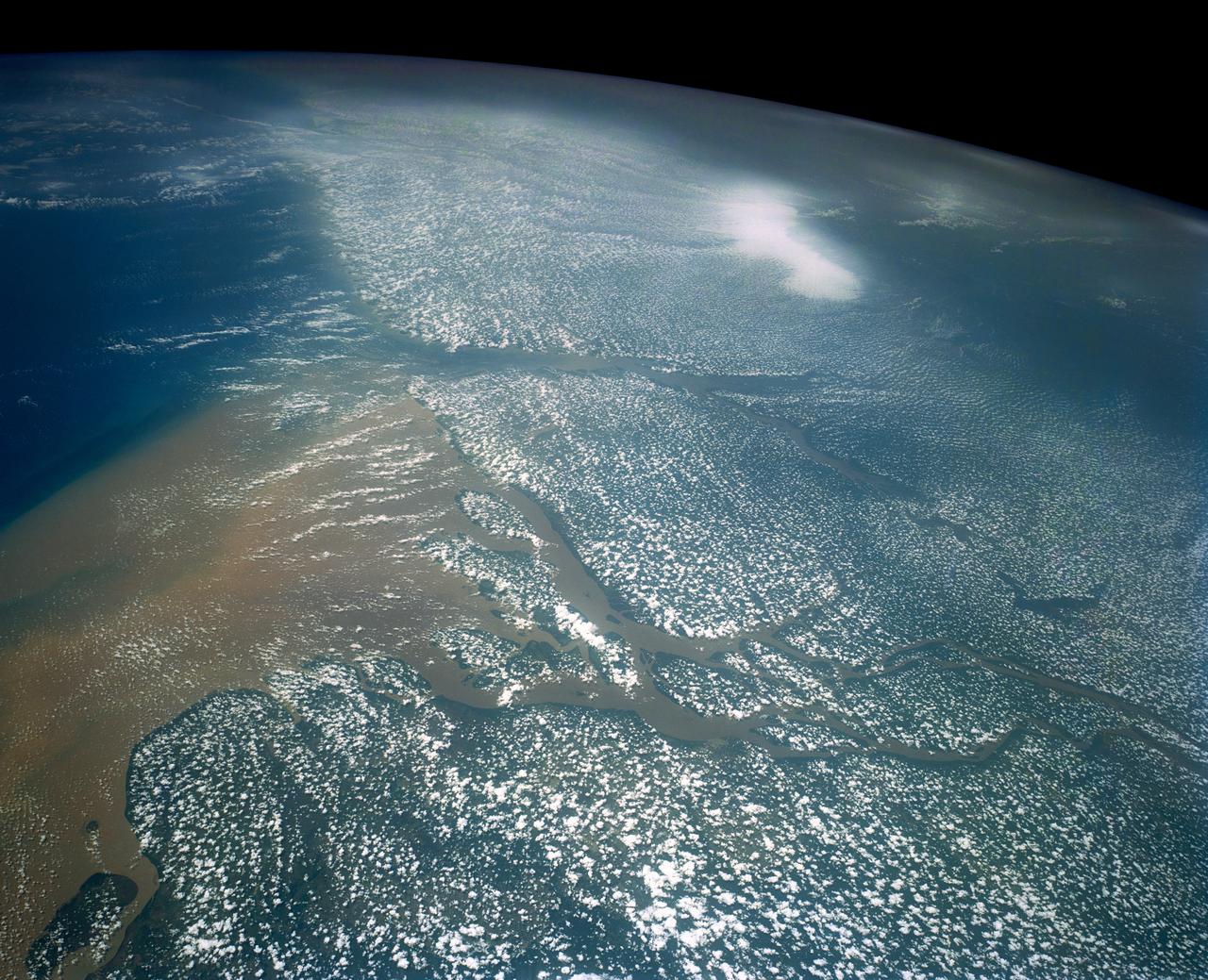
STS046-80-009 (31 July-8 Aug. 1992) --- A view of the mouth of the Amazon River and the Amazon Delta shows a large sediment plume expanding outward into the Atlantic Ocean. The sediment plume can be seen hugging the coast north of the Delta. This is caused by the west-northwest flowing Guyana Current. The large island of Marajo is partially visible through the clouds.
SL3-33-167 (July-September 1973) --- A vertical view of the Argentina-Paraguay border area of South America as photographed from Earth orbit by one of the six lenses of the Itek-furnished S190-A Multispectral Photographic Facility Experiment aboard the Skylab space station. This picture was taken with type 2443 infrared color film. The Parana River flows from east to west across the picture. This part of the Rio Parana is located between the towns of Posadas, Argentina, and Resistencia, Argentina. The major body of water in the large swamp area is Laguna Ibera. Note the several fires burning in this area. The largest land mass (Argentina) is south of the river. Paraguay is north of the river. Isla Apipe Grande is near the center of the photograph. The S190-A experiment is part of the Skylab Earth Resources Experiments Package. Federal agencies participating with NASA on the EREP project are the Departments of Agriculture, Commerce, Interior, the Environmental Protection Agency and the Corps of Engineers. All EREP photography is available to the public through the Department of Interior?s Earth Resources Observations Systems Data Center, Sioux Falls, South Dakota, 57198. Photo credit: NASA
SL3-84-202 (July-September 1973) --- A vertical view of the Montevideo, Uruguay area of South America is seen in this Skylab 3 Earth Resources Experiments Package S190-B (five-inch Earth terrain camera) photograph taken from the Skylab space station in Earth orbit. The large body of water is Rio de la Plata which flows into the South Atlantic Ocean at the bottom of the picture. The red plum in the Rio de la Plata is probably sediment moving seaward. The Santa Lucia River enters the Rio de la Plata west of Montevideo and is the major drainage for the region. Note the small Isla del Tigre at the mouth of the Santa Lucia. The white beach and sand dune areas are plainly visible along the coast. A major airport can be seen immediately east of downtown Montevideo. Major thoroughfares and residential areas, such as the bright one in the suburbs, are clearly visible, also. Farm tracts in green and grey rectangular patterns indicate agricultural regions. Photo credit: NASA
iss069e060833 (Aug. 15, 2023) --- South Dakota's Missouri River and its tributary the White River are pictured from the International Space Station as it orbited 264 miles above North America.
iss064e014990 (Dec. 23, 2020) --- The Amazon River is pictured from the International Space Station as it orbited 260 miles above Brazil in South America.

AS08-16-2593 (21-27 Dec. 1968) --- A striking view from the Apollo 8 spacecraft showing nearly the entire Western Hemisphere, from the mouth of the St. Lawrence River, including nearby Newfoundland, extending to Tierra del Fuego at the southern tip of South America. Central America is clearly outlined. Nearly all of South America is covered by clouds, except the high Andes Mountain chain along the west coast. A small portion of the bulge of West Africa shows along the sunset terminator.

iss071e051833 (May 6, 2024) --- Asunción, the capital city of Paraguay on the Paraguay River, and its suburbs across the border from Argentina are pictured from the International Space Station as it orbited 261 miles above South America.
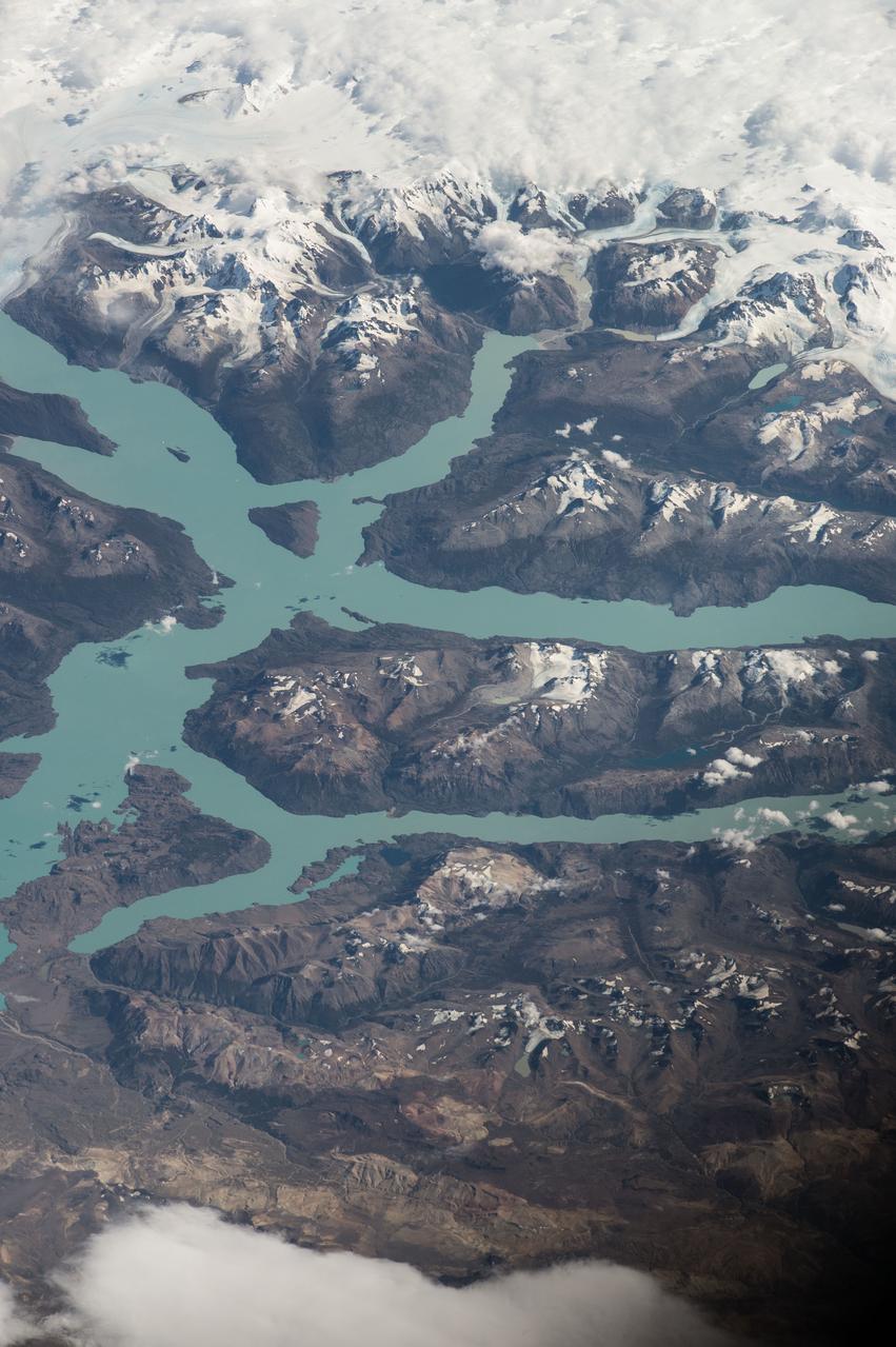
ISS047e014747 (03/22/2016) --- Crewmembers of the International Space Stations Expedition 47 captured this image of southern South America. Patagonia is a sparsely populated region located at the southern end of South America, shared by Argentina and Chile. The region comprises the southern section of the Andes mountains as well as the deserts, steppes and grasslands east of this southern portion of the Andes. The Colorado and Barrancas rivers, which run from the Andes to the Atlantic, are commonly considered the northern limit of Argentine Patagonia

A paper led by researchers at NASA's Jet Propulsion Laboratory estimates the total volume of water in Earth's rivers – called river storage – on average between 1980 and 2009, and maps out the results for the planet's major hydrological regions. This graphic, adapted from data gathered for the paper, indicates the amount of storage by hydrologic regions that contain one or more river basins, with shades of blue deepening as the amount of storage increases. The paper, published in Nature Geoscience in April 2024, calculated Earth's river storage at about 539 cubic miles (2,246 cubic kilometers), and found that the Amazon River basin, shown in dark blue in South America, was the region with the most storage, with 204 cubic miles (850 cubic kilometers), or about 38% of the global total. The study also estimated the flow of water through more than 3 million segments of river around the world and identified several locations marked by intense human water use, including parts of the Colorado River basin in the United States, portions of the Amazon basin in South America, the Orange River basin in southern Africa, and the Murray-Darling basin in southeastern Australia. https://photojournal.jpl.nasa.gov/catalog/PIA26119
iss061e004579 (Oct. 18, 2019) --- The Nottaway River empties into the southern tip of James Bay in the Canadian province of Quebec. The International Space Station was orbiting 252 miles above North America and 189 miles south of James Bay at the time this photograph was taken.
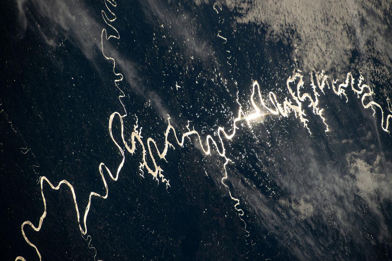
ISS038e014408 (10 Dec. 2013) --- What at first glance might appear to be a piece of modern art is actually a nadir perspective of part of the Amazon River system in South America, as photographed by one of the Expedition 38 crew members aboard the International Space Station. The astronaut used an 800mm lens to record the image on Dec. 10, 2013.
iss067e034812 (May 5, 2022) --- The Paraná River, pictured from the International Space Station at an altitude of 269 miles, leads into the Paraná Delta and empties into the Rio de la Plata which separates Argentina from Uruguay on South America's Atlantic coast. The fertile lowlands region is also known as the Pampas.
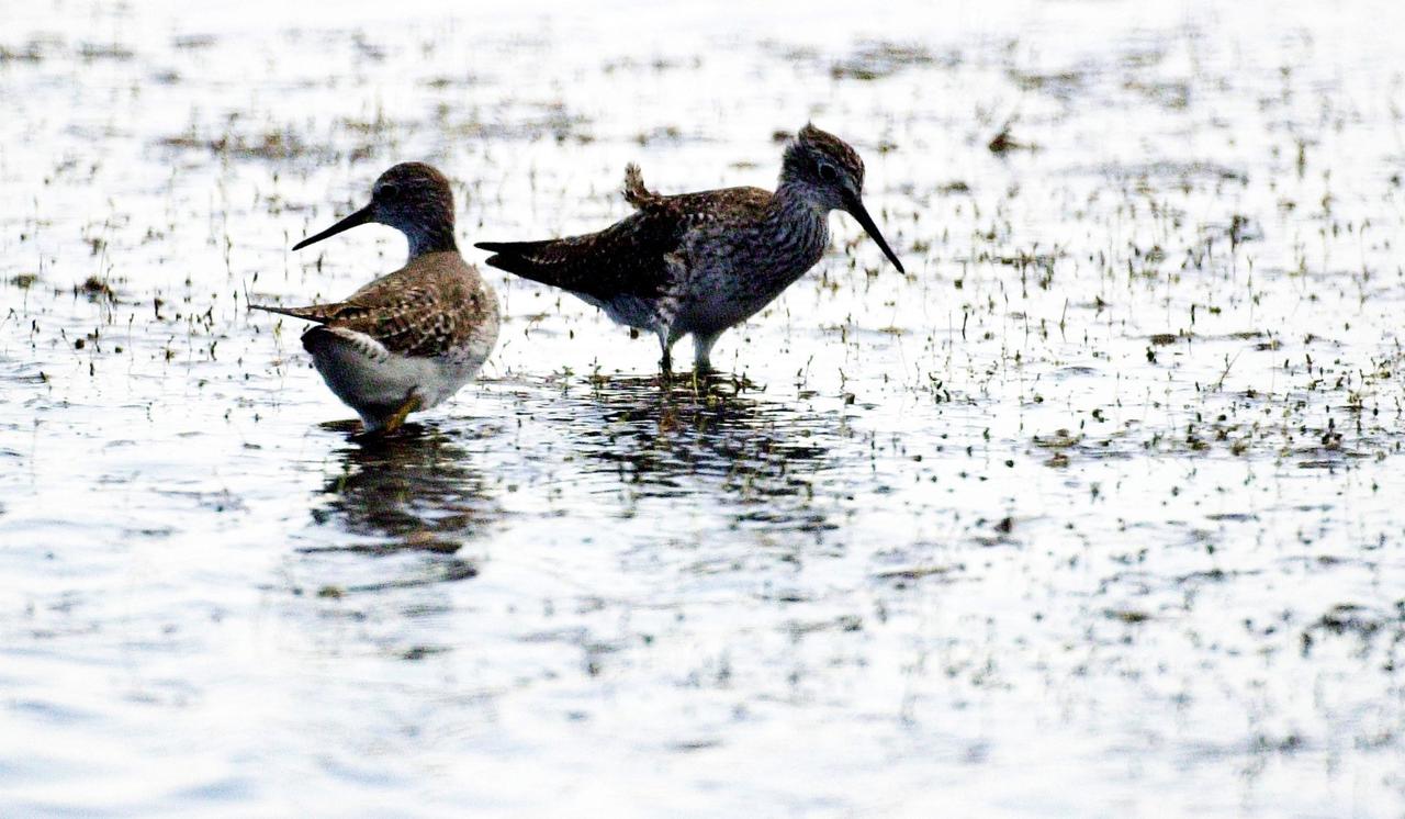
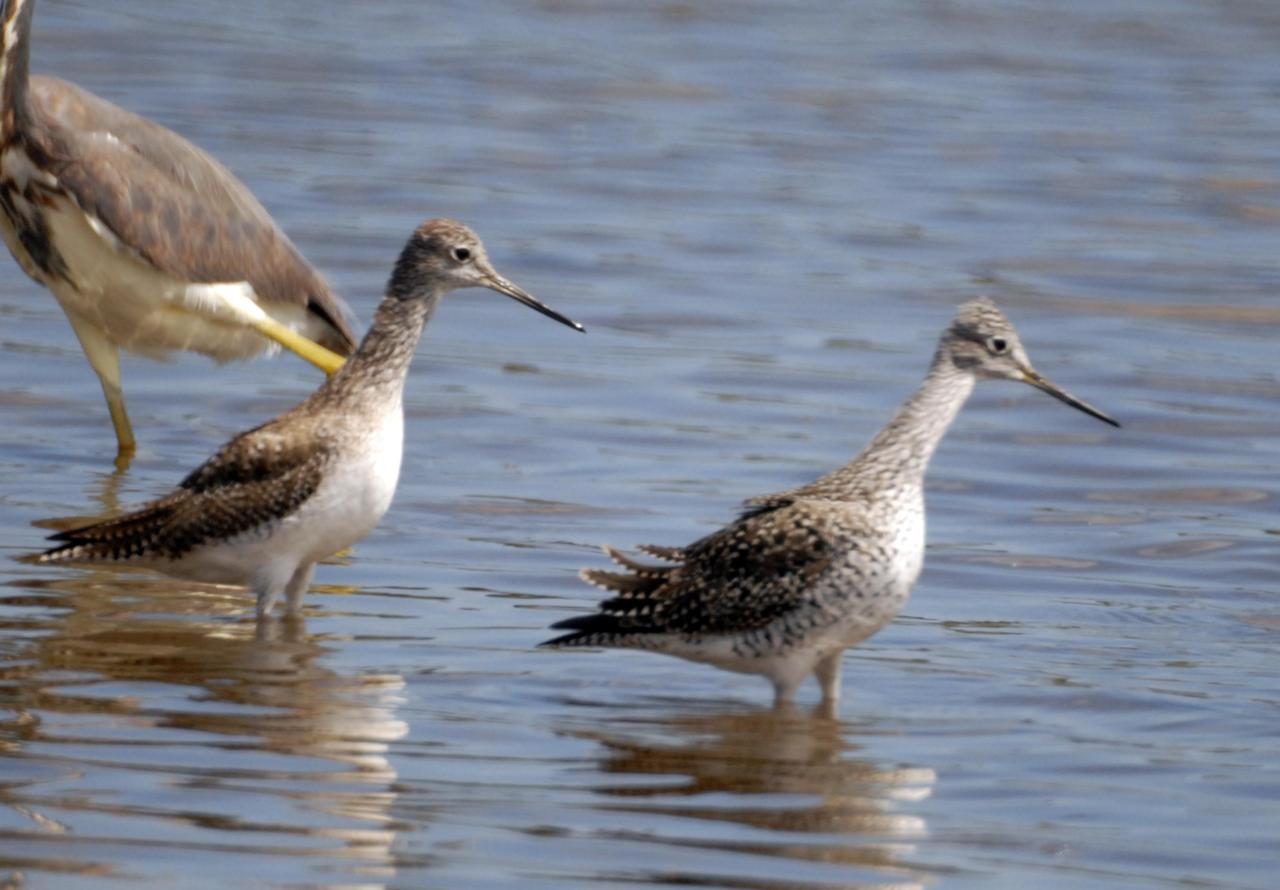
KENNEDY SPACE CENTER, FLA. -- A pair of Lesser Yellowlegs search a lake near Kennedy Space Center for food. The species inhabits marshy ponds, lake and river shores, and mud flats. They range from Alaska and Canada, wintering in the southern United States and South America.
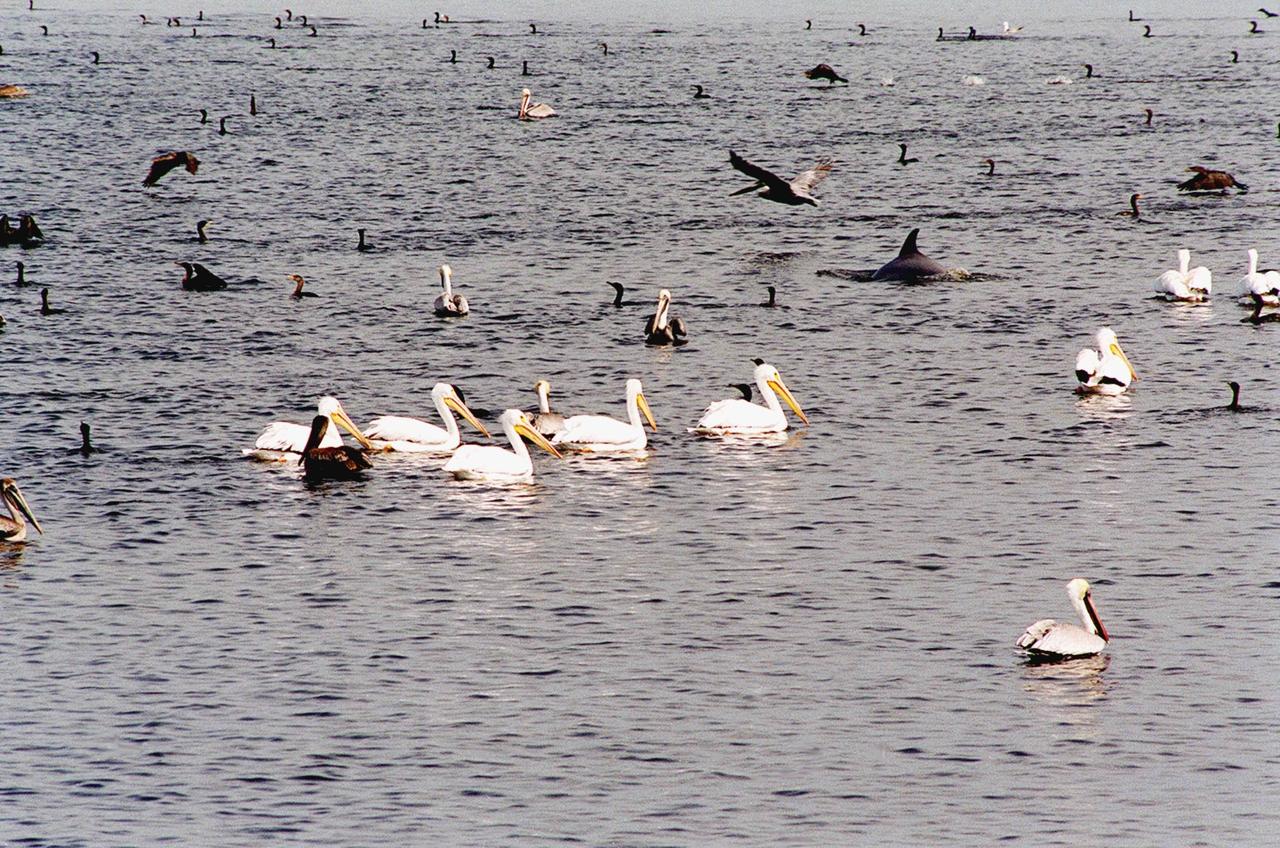
KENNEDY SPACE CENTER, FLA. -- The water in the turn basin, east of the Vehicle Assembly Building and next to the crawlerway, teems with fish and draws white pelicans, gray pelicans, cormorants, sea gulls and more looking for a meal. The turn basin is part of the Indian River Lagoon, composed of Mosquito Lagoon to the north, Banana River and Creek to the south and the Indian River to the west. The Indian River Lagoon has one of the most diverse bird populations anywhere in America. Also, nearly one-third of the nation's manatee population lives here or migrates through the lagoon seasonally. The lagoon varies in width from ½ mile to 5 miles and averages only 3 feet in depth

KENNEDY SPACE CENTER, FLA. -- The water in the turn basin, east of the Vehicle Assembly Building and next to the crawlerway, teems with fish and draws white pelicans, gray pelicans, cormorants, sea gulls and more looking for a meal. The turn basin is part of the Indian River Lagoon, composed of Mosquito Lagoon to the north, Banana River and Creek to the south and the Indian River to the west. The Indian River Lagoon has one of the most diverse bird populations anywhere in America. Also, nearly one-third of the nation's manatee population lives here or migrates through the lagoon seasonally. The lagoon varies in width from ½ mile to 5 miles and averages only 3 feet in depth
iss073e0866294 (Oct. 8, 2025) --- Montreal, Quebec, the second-most populous Canadian city with a metropolitan population of about 4.29 million, sits between the Prairies River to its north and the St. Lawrence River to the south. Montreal is named after Mount Royal, a prominent and natural landmark in the heart of the city. Montréal-Pierre Elliott Trudeau International Airport, voted North America's cleanest airport in 2025, is pictured near the bank of the St. Lawrence from the International Space Station as it orbited 263 miles above the Earth.

Smokey Bear, left, and Judy Reese of the Crooked River National Grassland, right, wave at passersby as crowds arrive to watch the total solar eclipse in Madras, Oregon on Saturday, August 19, 2017. The eclipse will be sweeping across a narrow portion of the contiguous United States from Lincoln Beach, Oregon to Charleston, South Carolina on August 21. A partial solar eclipse will be visible across the entire North American continent along with parts of South America, Africa, and Europe. Photo Credit: (NASA/Aubrey Gemignani)
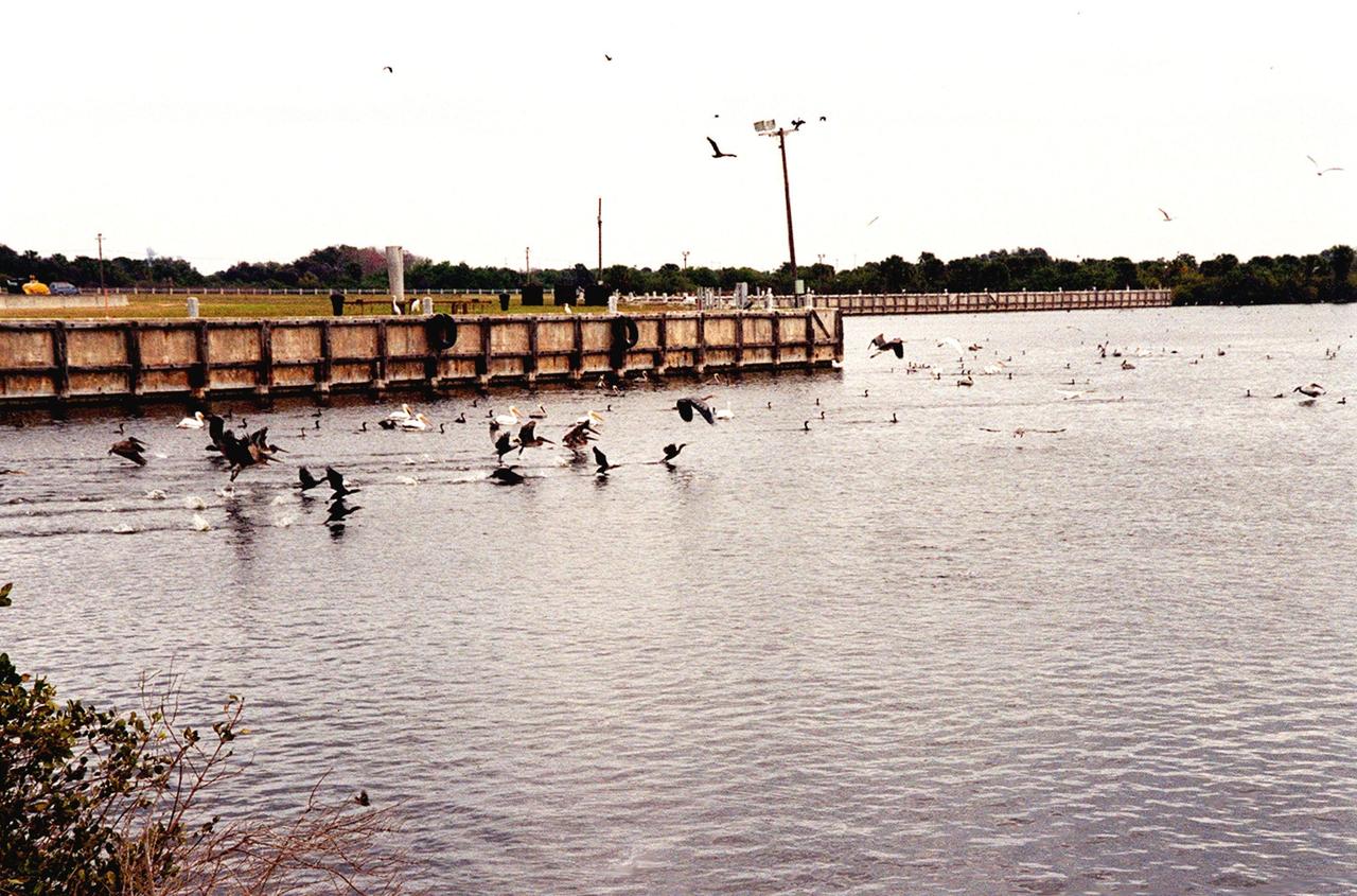
KENNEDY SPACE CENTER, FLA. -- Birds by the score, especially gray and white pelicans, cormorants, sea gulls, herons and ospreys, flock to the turn basin east of the Vehicle Assembly Building in a feeding frenzy as schools of fish fill the waters. In the background is Launch Pad A with Space Shuttle Endeavour waiting for launch on Friday, Feb. 11 for mission STS-99. The basin is part of the Indian River Lagoon, which is made up of Mosquito Lagoon to the north, Banana River and Creek to the south and the Indian River to the west. It is called a lagoon because it is a body of water separated from the ocean by barrier islands, with limited exchange with the ocean through inlets. The Indian River Lagoon has one of the most diverse bird populations anywhere in America. Also, nearly one-third of the nation's manatee population lives here or migrates through the lagoon seasonally. The lagoon varies in width from ½ mile to 5 miles and averages only 3 feet in depth

KENNEDY SPACE CENTER, FLA. -- Birds by the score, especially gray and white pelicans, cormorants, sea gulls, herons and ospreys, flock to the turn basin east of the Vehicle Assembly Building in a feeding frenzy as schools of fish fill the waters. In the background is Launch Pad A with Space Shuttle Endeavour waiting for launch on Friday, Feb. 11 for mission STS-99. The basin is part of the Indian River Lagoon, which is made up of Mosquito Lagoon to the north, Banana River and Creek to the south and the Indian River to the west. It is called a lagoon because it is a body of water separated from the ocean by barrier islands, with limited exchange with the ocean through inlets. The Indian River Lagoon has one of the most diverse bird populations anywhere in America. Also, nearly one-third of the nation's manatee population lives here or migrates through the lagoon seasonally. The lagoon varies in width from ½ mile to 5 miles and averages only 3 feet in depth
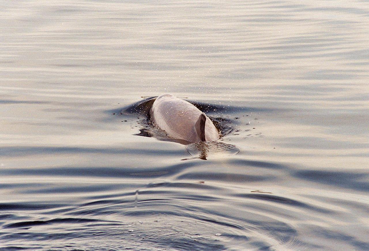
KENNEDY SPACE CENTER, FLA. -- A dolphin glides through the water looking for fish in the turn basin, which is located east of the Vehicle Assembly Building and next to the crawlerway. Dolphins inhabit the waters, known as the Indian River Lagoon, around Kennedy Space Center, along with many different species of oceanic and lagoon fish and shellfish. Mosquito Lagoon to the north, Banana River and Creek to the south and the Indian River to the west make up a special type of estuary called a lagoon, a body of water separated from the ocean by barrier islands, with limited exchange with the ocean through inlets. The Indian River Lagoon has one of the most diverse bird populations anywhere in America. Also, nearly one-third of the nation's manatee population lives here or migrates through the lagoon seasonally. The lagoon varies in width from ½ mile to 5 miles and averages only 3 feet in depth

KENNEDY SPACE CENTER, FLA. -- A dolphin glides through the water looking for fish in the turn basin, which is located east of the Vehicle Assembly Building and next to the crawlerway. Dolphins inhabit the waters, known as the Indian River Lagoon, around Kennedy Space Center, along with many different species of oceanic and lagoon fish and shellfish. Mosquito Lagoon to the north, Banana River and Creek to the south and the Indian River to the west make up a special type of estuary called a lagoon, a body of water separated from the ocean by barrier islands, with limited exchange with the ocean through inlets. The Indian River Lagoon has one of the most diverse bird populations anywhere in America. Also, nearly one-third of the nation's manatee population lives here or migrates through the lagoon seasonally. The lagoon varies in width from ½ mile to 5 miles and averages only 3 feet in depth
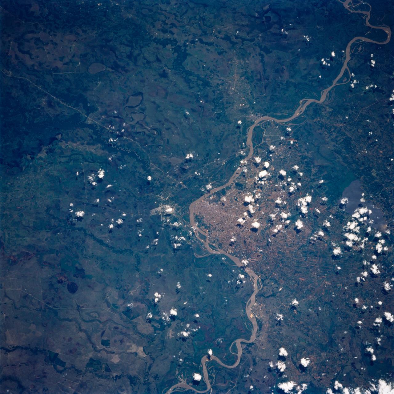
ISS010-E-05070 (25 October 2004) --- Corrientes, Argentina, and the Parana River are featured in this image photographed by an Expedition 10 crewmember on the International Space Station (ISS). Corrientes, Argentina sits on the east bank of the Parana River, South America’s third largest river (after the Negro and Amazon Rivers). From its headwaters in southeastern Brazil, the river flows southwestward around southern Paraguay, and then into Argentina. Corrientes is located just inside Argentina, across the river from the southwestern tip of Paraguay. The bridge over the Parana, built in the 1970s, connects Corrientes to its sister city, Resistencia, (beyond the left edge of image) on the western bank of the river. Sun glint on the river gives it a silvery glow and emphasizes channel islands in the river, side channels, and meander scars on the floodplain opposite the city, and even reveals the pattern of disturbed flow downstream of the bridge pylons. The old part of the city appears as a zone of smaller, more densely clustered city blocks along the river to the north of a major highway, which runs through Corrientes from the General Belgrano Bridge to the northeast (upper right of image). Larger blocks of the younger cityscape, with more green space, surround these core neighborhoods.
STS054-151-150 (13-19 Jan 1993) --- View west into sun glint off the Rio Salado, Saladillo, and Parana Rivers in Argentina. The Space Shuttle nadir is about 28 degrees north latitude and 57 degrees west longitude. The Andes Mountains are barely visible on Earth's limb. Thunderstorms along the eastern edge of the Andes are typical of this time of year (Southern Hemisphere summer), with anvils moving to the east from the core of the storm.
STS058-107-083 (18 Oct.-1 Nov. 1993) --- A near-nadir view of the mouth of the Amazon River, that shows all signs of being a relatively healthy system, breathing and exhaling. The well-developed cumulus field over the forested areas on both the north and south sides of the river (the view is slightly to the west) shows that good evapotranspiration is underway. The change in the cloud field from the moisture influx from the Atlantic (the cloud fields over the ocean are parallel to the wind direction) to perpendicular cloud fields over the land surface are normal. This change in direction is caused by the increased surface roughness over the land area. The plume of the river, although turbid, is no more or less turbid than it has been reported since the Portuguese first rounded Brasil's coast at the end of the 15th Century.
iss057e055559 (Oct. 22, 2018) --- The rural community of Grand View, Idaho is just south of the Ted Trueblood Wildlife Area which can host a variety of thousands of birds during migration periods. Snake River flows through the area and also forms portions of the Idaho, Oregon and Washington borders. The International Space Station was orbiting 256 miles above North America when this photograph was taken.
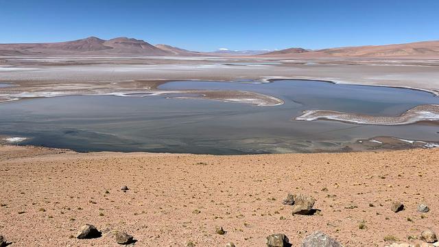
Filled with briny lakes, the Quisquiro salt flat in South America's Altiplano represents the kind of landscape that scientists think may have existed in Gale Crater, which NASA's Curiosity rover is exploring. This salt flat is located in Chile, though the Altiplano sprawls across countries. Streams and rivers flowing from mountain ranges into this arid, high-altitude plateau lead to closed basins similar to Mars' ancient Gale Crater. Lakes on the Altiplano are heavily influenced by climate in the same way as Gale. https://photojournal.jpl.nasa.gov/catalog/PIA23374
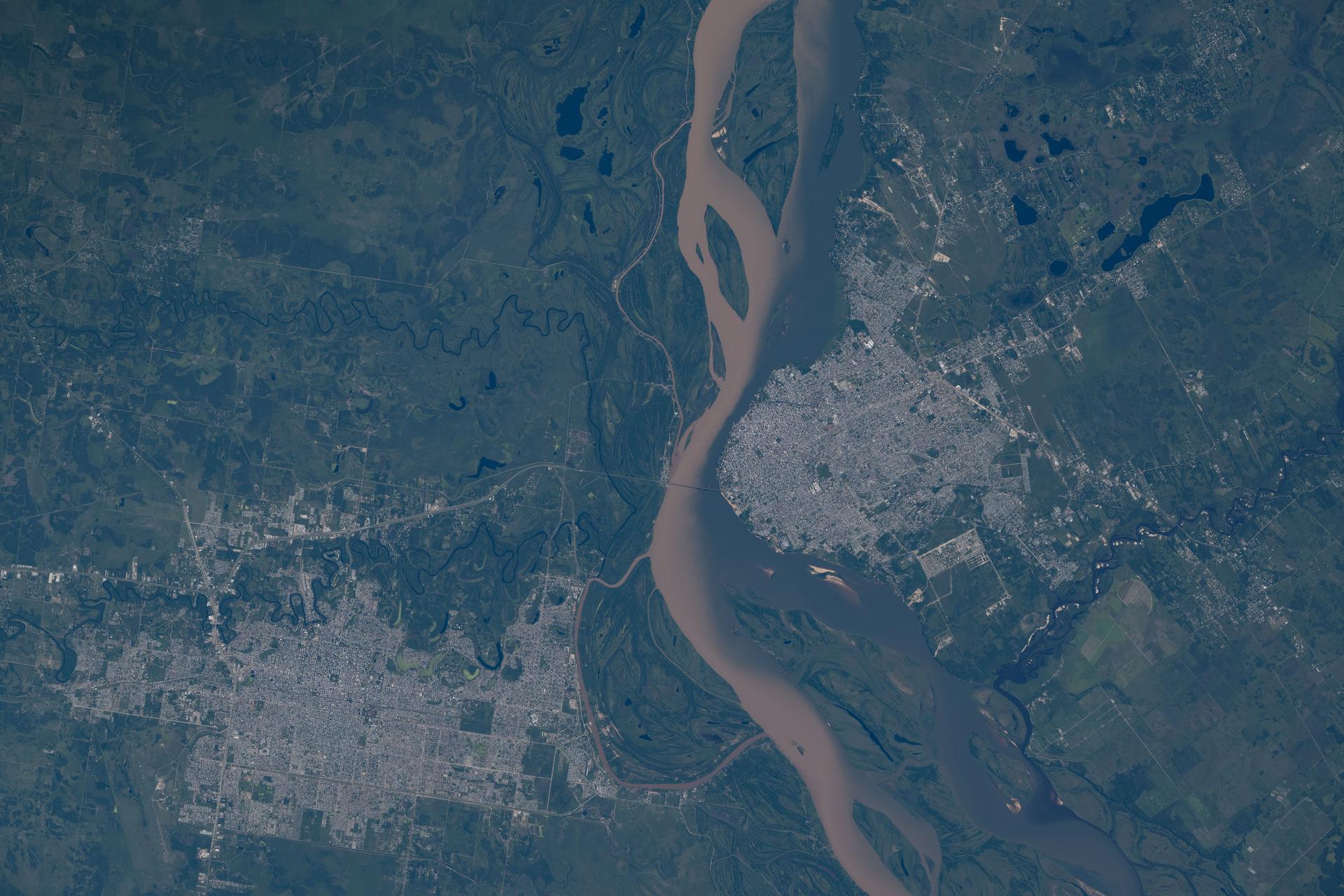
iss074e0046040 (Jan. 5, 2025) --- From left, the cities of Resistencia and Corrientes—both cultural and economic hubs with a combined population of over 888,000—are separated by the Paraná River in northeastern Argentina near the Paraguay border. The International Space Station was orbiting 268 miles above South America when this photograph was taken. Credit: NASA/Chris Williams
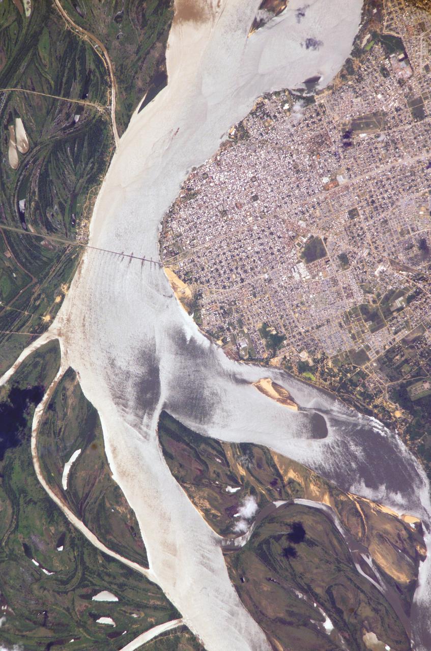
STS072-730-079 (11-20 Jan. 1996) --- Asuncion, capital city of Paraguay, South America (population 1.2 million) appears as de-vegetated countryside, in this 70mm photograph from the Space Shuttle Endeavour. The frame is focused at the downtown area next to the major bend of the Paraguay river. As the intensity of land use declines away from the center, the countryside becomes greener. Large farm plots can be seen at the bottom of the view. Lake Ypacarai (at the bottom) is a resort location surrounded by second homes for Paraguay's more affluent citizens. The top left corner of the photograph is northernmost Argentina, a remote, underdeveloped part of the country. Ships carry Paraguay's small import and export traffic down the Paraguay and Parana Rivers to Buenos Aires, the major port of the region hundreds of miles to the south (left). This may be the best shot of Asuncion so far during the Shuttle Program. The area spans 45 miles across the base of the picture. The river flows south (right to left).

KENNEDY SPACE CENTER, FLA. -- Hundreds of birds, especially gray and white pelicans and cormorants, cover the water in the turn basin, located east of the Vehicle Assembly Building and next to the crawlerway. The basin is teeming with fish, attracting the crowd for a meal. The turn basin is part of the Indian River Lagoon, composed of Mosquito Lagoon to the north, Banana River and Creek to the south and the Indian River to the west. The lagoon has one of the most diverse bird populations anywhere in America, plus many different species of oceanic and lagoon fish, shellfish and dolphins. Also, nearly one-third of the nation's manatee population lives here or migrates through the Lagoon seasonally. The Lagoon varies in width from ½ mile to 5 miles and averages only 3 feet in depth
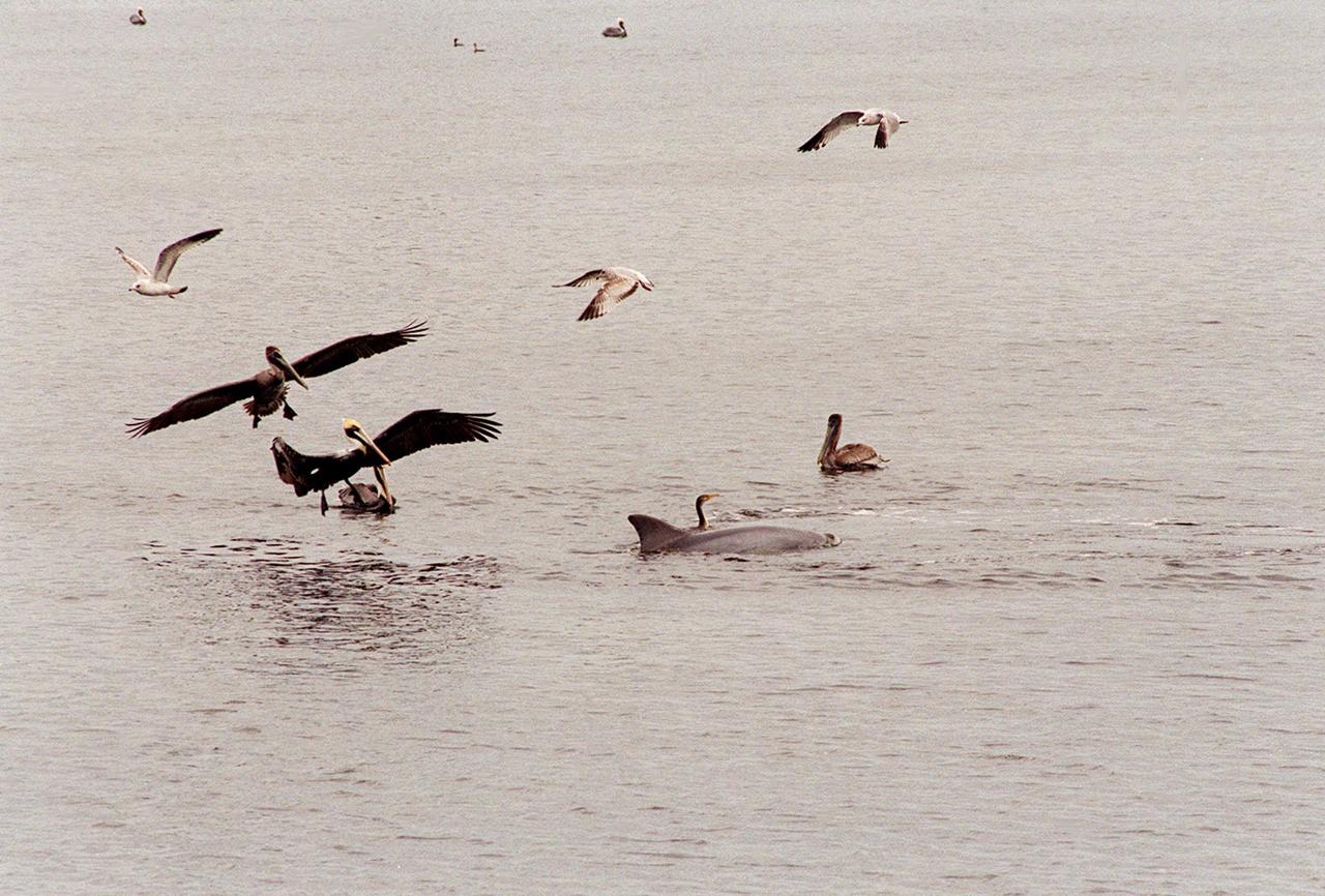
KENNEDY SPACE CENTER, FLA. -- A gray and a white pelican glide down to the water near a dolphin and cormorant in the turn basin to search for a meal in the fish-teeming water. Sea gulls also approach. The turn basin, which is east of the Vehicle Assembly Building and next to the crawlerway, is part of the Indian River Lagoon, composed of Mosquito Lagoon to the north, Banana River and Creek to the south and the Indian River to the west. The lagoon has one of the most diverse bird populations anywhere in America, plus many different species of oceanic and lagoon fish, shellfish and dolphins. Also, nearly one-third of the nation's manatee population lives here or migrates through the Lagoon seasonally. The Lagoon varies in width from ½ mile to 5 miles and averages only 3 feet in depth

KENNEDY SPACE CENTER, FLA. -- A gray and a white pelican glide down to the water near a dolphin and cormorant in the turn basin to search for a meal in the fish-teeming water. Sea gulls also approach. The turn basin, which is east of the Vehicle Assembly Building and next to the crawlerway, is part of the Indian River Lagoon, composed of Mosquito Lagoon to the north, Banana River and Creek to the south and the Indian River to the west. The lagoon has one of the most diverse bird populations anywhere in America, plus many different species of oceanic and lagoon fish, shellfish and dolphins. Also, nearly one-third of the nation's manatee population lives here or migrates through the Lagoon seasonally. The Lagoon varies in width from ½ mile to 5 miles and averages only 3 feet in depth

KENNEDY SPACE CENTER, FLA. -- The water in the turn basin, located east of the Vehicle Assembly Building and next to the crawlerway, teems with fish and draws white pelicans, gray pelicans, cormorants, sea gulls and one of several dolphins looking for a meal. The turn basin is part of the Indian River Lagoon, composed of Mosquito Lagoon to the north, Banana River and Creek to the south and the Indian River to the west. The lagoon has one of the most diverse bird populations anywhere in America, plus many different species of oceanic and lagoon fish, shellfish and dolphins. Also, nearly one-third of the nation's manatee population lives here or migrates through the lagoon seasonally. The lagoon varies in width from ½ mile to 5 miles and averages only 3 feet in depth
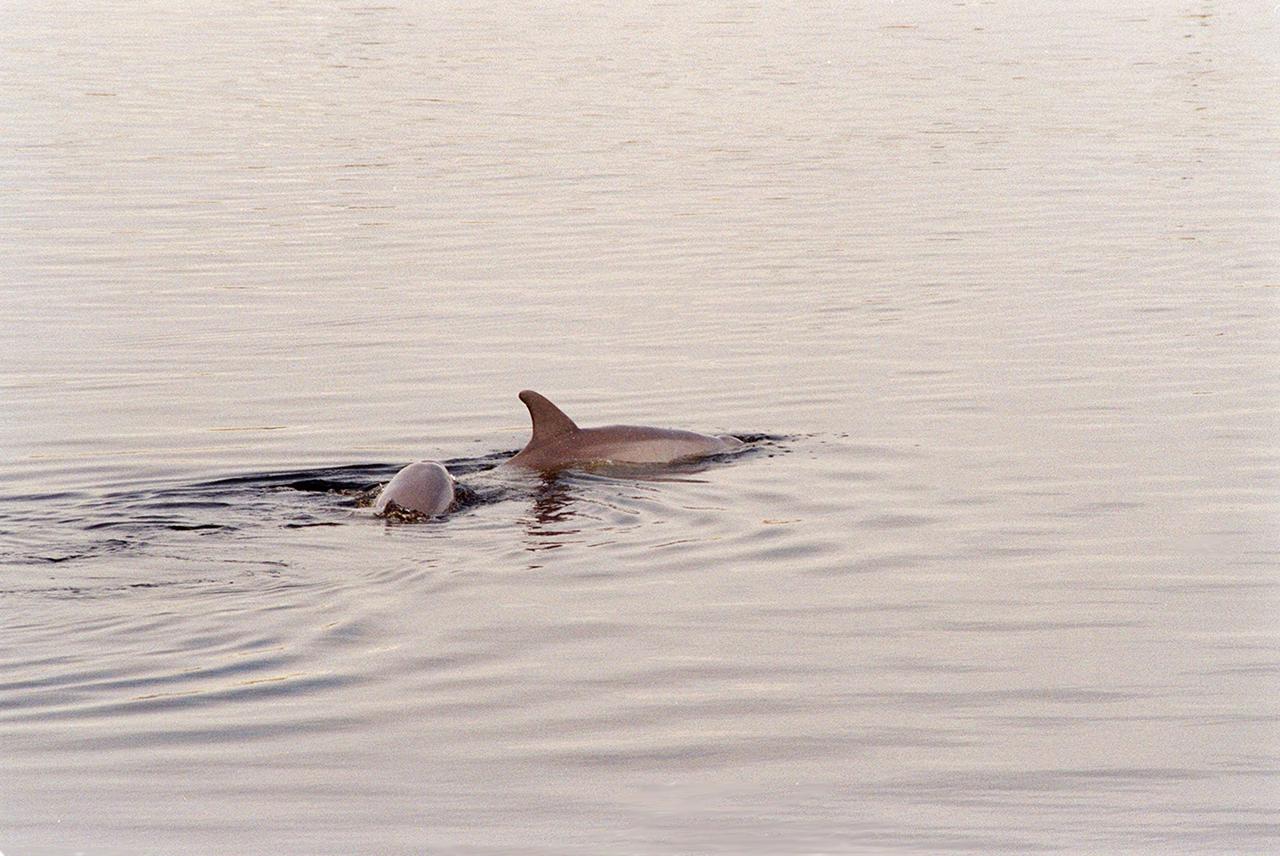
KENNEDY SPACE CENTER, FLA. -- In the turn basin east of the Vehicle Assembly Building and next to the crawlerway, a mother dolphin guides her baby through the water to search for food. Dolphins inhabit the waters around Kennedy Space Center, along with many different species of oceanic and lagoon fish and shellfish. Mosquito Lagoon to the north, Banana River and Creek to the south and the Indian River to the west make up a special type of estuary called a lagoon, a body of water separated from the ocean by barrier islands, with limited exchange with the ocean through inlets. The Indian River Lagoon has one of the most diverse bird populations anywhere in America. Also, nearly one-third of the nation's manatee population lives here or migrates through the lagoon seasonally. The lagoon varies in width from ½ mile to 5 miles and averages only 3 feet in depth
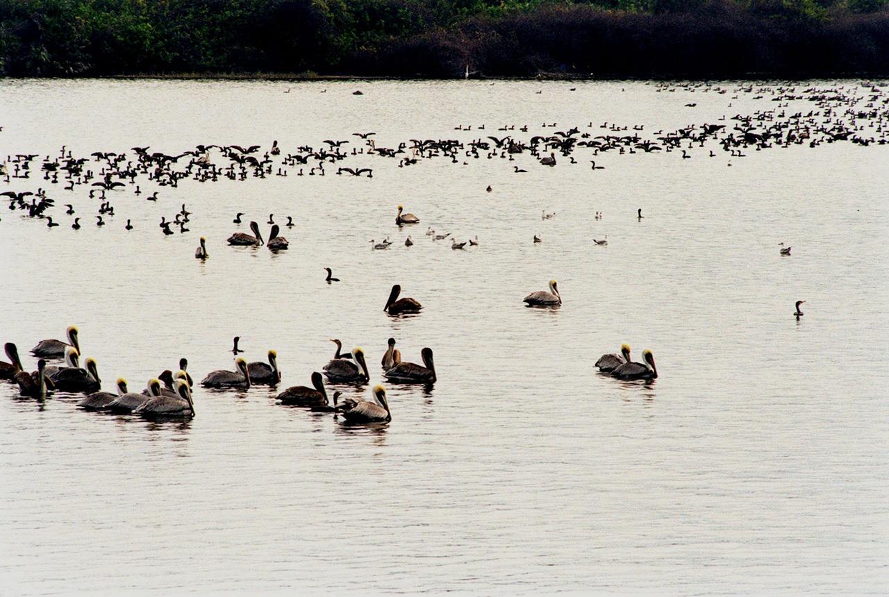
KENNEDY SPACE CENTER, FLA. -- Hundreds of birds, especially gray and white pelicans and cormorants, cover the water in the turn basin, located east of the Vehicle Assembly Building and next to the crawlerway. The basin is teeming with fish, attracting the crowd for a meal. The turn basin is part of the Indian River Lagoon, composed of Mosquito Lagoon to the north, Banana River and Creek to the south and the Indian River to the west. The lagoon has one of the most diverse bird populations anywhere in America, plus many different species of oceanic and lagoon fish, shellfish and dolphins. Also, nearly one-third of the nation's manatee population lives here or migrates through the Lagoon seasonally. The Lagoon varies in width from ½ mile to 5 miles and averages only 3 feet in depth
KENNEDY SPACE CENTER, FLA. -- The water in the turn basin, located east of the Vehicle Assembly Building and next to the crawlerway, teems with fish and draws white pelicans, gray pelicans, cormorants, sea gulls and one of several dolphins looking for a meal. The turn basin is part of the Indian River Lagoon, composed of Mosquito Lagoon to the north, Banana River and Creek to the south and the Indian River to the west. The lagoon has one of the most diverse bird populations anywhere in America, plus many different species of oceanic and lagoon fish, shellfish and dolphins. Also, nearly one-third of the nation's manatee population lives here or migrates through the lagoon seasonally. The lagoon varies in width from ½ mile to 5 miles and averages only 3 feet in depth

KENNEDY SPACE CENTER, FLA. -- In the turn basin east of the Vehicle Assembly Building and next to the crawlerway, a mother dolphin guides her baby through the water to search for food. Dolphins inhabit the waters around Kennedy Space Center, along with many different species of oceanic and lagoon fish and shellfish. Mosquito Lagoon to the north, Banana River and Creek to the south and the Indian River to the west make up a special type of estuary called a lagoon, a body of water separated from the ocean by barrier islands, with limited exchange with the ocean through inlets. The Indian River Lagoon has one of the most diverse bird populations anywhere in America. Also, nearly one-third of the nation's manatee population lives here or migrates through the lagoon seasonally. The lagoon varies in width from ½ mile to 5 miles and averages only 3 feet in depth
STS043-151-159 (2-11 August 1991) --- This photograph looks westward over the high plateau of the southern Peruvian Andes west and north of Lake Titicaca (not in field of view). Lima, Peru lies under the clouds just north of the clear coastal area. Because the high Andes have been uplifted 10,000 to 13,000 feet during the past 20 million years, the rivers which cut down to the Pacific Ocean have gorges almost that deep, such as the Rio Ocona at the bottom of the photograph. The eastern slopes of the Andes are heavily forested, forming the headwaters of the Amazon system. Smoke from burning in the Amazon basin fills river valleys on the right side of the photograph. A Linhof camera was used to take this view.
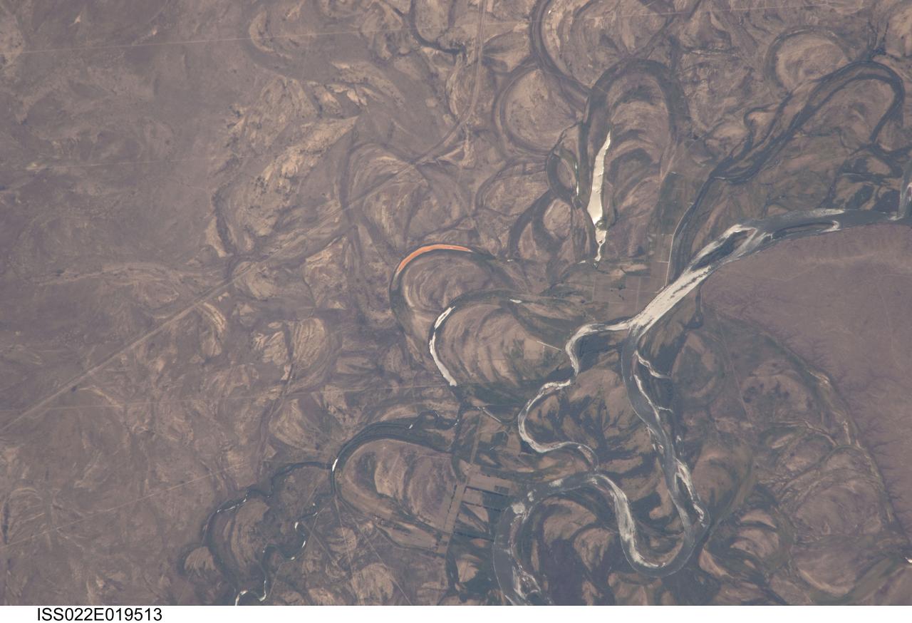
ISS022-E-019513 (4 Jan. 2010) --- The Rio Negro floodplain in Patagonia, Argentina is featured in this image photographed by an Expedition 22 crew member on the International Space Station. The Rio Negro is recognizable by astronaut crews from orbit as one of the most meandering rivers in South America. This is well illustrated in this view, where the entire river floodplain (approximately 10 kilometers wide) is covered with curved relics of channels known as meander scars. The main channel of the river, flowing south at this point?60 kilometers south of the city of Choele Choel (not shown)?appears in partial sun glint at right. Sun glint occurs when light is reflected off a water surface directly back towards the viewer, imparting a silvery sheen to those areas. When meander scars contain water they are known as oxbow lakes, some of which are also highlighted by sun glint in the image. Meander scars show the numerous past positions of river bends, produced as the river snaked across the plain in the very recent geological past. The Rio Negro is a dramatic example of how mobile a river can be. The orange tint to the water in one of the oxbow lakes (center) could result from orange salt-loving algae. Their appearance here would be unusual since floodplain lakes are usually too fresh for algae blooms. But an explanation may lie in the location of the Rio Negro on the margin of Argentina?s arid Patagonian region with annual rainfall less than 12 inches (300 mm). Evaporation in this cloudless region could be high enough for some lakes to become salty. The Rio Negro flows generally southeast from the Andes Mts. to the Atlantic Ocean. Its floodplain supports the biggest pear- and apple-growing region of Argentina. Rectangular farm boundaries can be seen at bottom center. The river also hosts the world?s longest kayak regatta (653 kilometers), which lasts six days.
ISS032-E-016579 (11 Aug. 2012) --- A strandplain on coastal Peru is featured in this image photographed by an Expedition 32 crew member on the International Space Station. The scale and orientation of landscape features that are difficult to see on the ground often become readily visible from orbit. Numerous subparallel lines (center) along the arid, northern coast of Peru (about five degrees south of the Equator) are close-packed beach ridges, known collectively as a strandplain (for scale, the strandplain is 30 kilometers long). Each ridge shows the position of a prior shoreline. The Chira River delta appears at right, with dark green agricultural fields occupying the delta of the river. A smaller river reaches the sea, without forming a delta, at extreme left. The prominent cape at lower left is Punta Balcones, a region with many oil wells. Strandplains are built by successive additions of beach sand usually from some nearby source. Currents on this coast of South America come from the south, suggesting to scientists that the Chira River delta (right) is the source of the sand. The newest beach is being formed today by the waves?which appear as the thin ragged white line along the strandplain?supplied by the north-flowing current. The regularity of the spacing of the beaches suggests that some episodic influx of sediment controls beach formation. This influx may be determined by floods coming down the Chira River, possibly controlled by the heavy rains of El Nino events which occur irregularly every few years. Two other sets of faint parallel lines can be seen on higher ground inland (between arrows, center and top right), the upper set stretching all the way from the Chira river floodplain. Seen in many places along the coast of Peru, scientists believe these may also be strandplains (i.e. formed at sea level) generated when the land surface was at a lower altitude; both also may have been produced by sand from the Chira River. The land surface is known to be rising along this coast with the rise of the Andes Mts. (outside the top of the image), explaining why the upper shorelines now lie 120 meters above sea level.

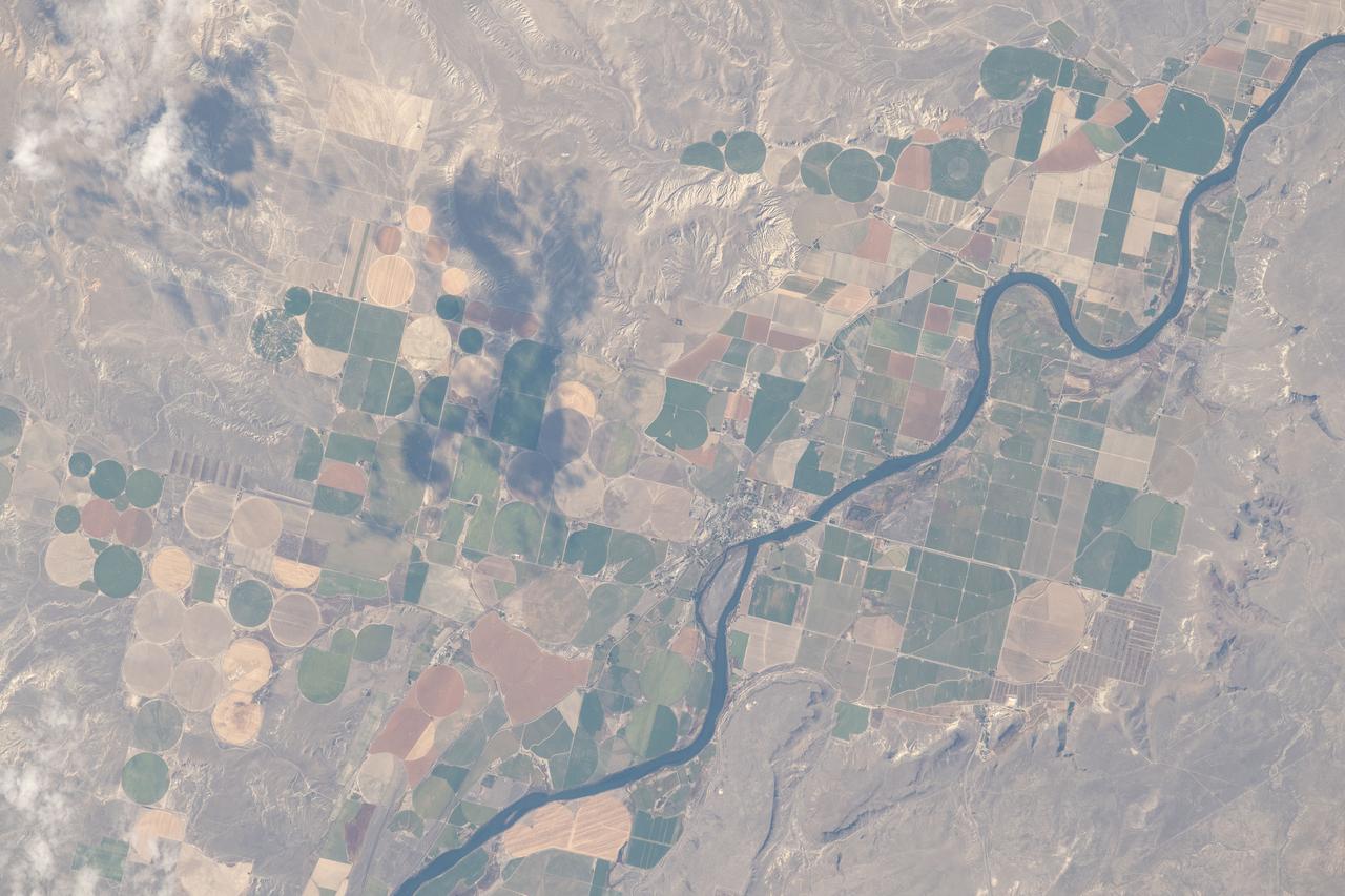
ISS038-E-023651 (26 Dec. 2013) --- Lake Sharpe near Lower Brule, South Dakota is featured in this image photographed by an Expedition 38 crew member on the International Space Station. The Missouri River rises in the Rocky Mountains of western Montana, and flows generally to the southeast for approximately 3,767 kilometers (2,341 miles) to its confluence with the Mississippi River north of St. Louis, Missouri -- making it the longest river in North America. The river does not follow a straight southeasterly course along this distance, but includes may meander bends such as illustrated in this photograph. This particular bend is occupied by Lake Sharpe, an approximately 130-kilometer (80 miles) long reservoir formed behind the Big Bend Dam on the Missouri River. The lake surface is frozen and covered with snow, presenting a uniform white appearance in the image. As meander bends develop, they tend to assume a distinctive U-shape when viewed from above. Over time, the river channel can continue to cut into the ends of the "U", eventually bringing them so close together that the river then cuts across the gap to achieve a shorter flow path, essentially short-circuiting or cutting off the meander bend. When this happens and the meander ceases to be part of the active river channel, it may become an oxbow lake. The distance across the narrow neck of land (lower right) associated with this meander near Lower Brule, South Dakota is approximately one kilometer (0.62 miles); however, as the river flow is controlled by the Big Bend Dam downstream, the natural process of meander cutoff has been significantly slowed. The snow cover also highlights circular agricultural fields on the small peninsula within the meander bend. This type of field indicates center-pivot irrigation, where water is distributed from a central point radially outwards using sprinklers to cover the field area. Crops grown here include corn and soybeans according to data from the US Department of Agriculture's CropScape database.

KENNEDY SPACE CENTER, FLA. -- In the turn basin east of the Vehicle Assembly Building and next to the crawlerway, a mother dolphin guides her baby through the water to search for food. Next to them on a rock is an osprey eating a fish. Dolphins inhabit the waters around Kennedy Space Center, along with many different species of oceanic and lagoon fish and shellfish. Mosquito Lagoon to the north, Banana River and Creek to the south and the Indian River to the west make up a special type of estuary called a lagoon, a body of water separated from the ocean by barrier islands, with limited exchange with the ocean through inlets. The Lagoon varies in width from ½ mile to 5 miles and averages only 3 feet in depth. Nearly one-third of the nation's manatee population lives here or migrates through the Lagoon seasonally. The lagoon also has one of the most diverse bird populations anywhere in America
KENNEDY SPACE CENTER, FLA. -- In the turn basin east of the Vehicle Assembly Building and next to the crawlerway, a mother dolphin guides her baby through the water to search for food. Next to them on a rock is an osprey eating a fish. Dolphins inhabit the waters around Kennedy Space Center, along with many different species of oceanic and lagoon fish and shellfish. Mosquito Lagoon to the north, Banana River and Creek to the south and the Indian River to the west make up a special type of estuary called a lagoon, a body of water separated from the ocean by barrier islands, with limited exchange with the ocean through inlets. The Lagoon varies in width from ½ mile to 5 miles and averages only 3 feet in depth. Nearly one-third of the nation's manatee population lives here or migrates through the Lagoon seasonally. The lagoon also has one of the most diverse bird populations anywhere in America
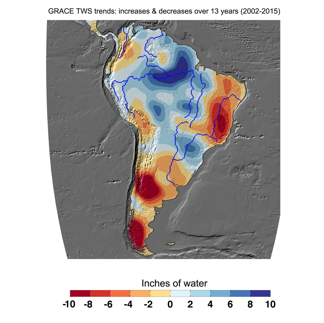
Cumulative total freshwater losses in South America from 2002 to 2015 (in inches) observed by NASA's Gravity Recovery and Climate Experiment (GRACE) mission. Total water refers to all of the snow, surface water, soil water and groundwater combined. Much of the Amazon River basin experienced increasing total water storage during this time period, though the persistent Brazilian drought is apparent to the east. Groundwater depletion strongly impacted total water losses in the Guarani aquifer of Argentina and neighboring countries. Significant water losses due to the melting ice fields of Patagonia are also observed. http://photojournal.jpl.nasa.gov/catalog/PIA20205
CAPE CANAVERAL, Fla. – A yellowleg sandpiper wades in the shallow water of a pond in the Merritt island National Wildlife Refuge, which borders NASA's Kennedy Space Center in Florida. They range through Alaska and Canada, wintering from the southern U.S. to southern South America. They inhabit marshy ponds, lake and river shores and mud flats. The center shares a boundary with the refuge that includes salt-water estuaries, brackish marshes, hardwood hammocks and pine flatwoods. The diverse landscape provides habitat for more than 310 species of birds, 25 mammals, 117 fishes and 65 amphibians and reptiles. Photo credit: NASA/Jim Grossmann
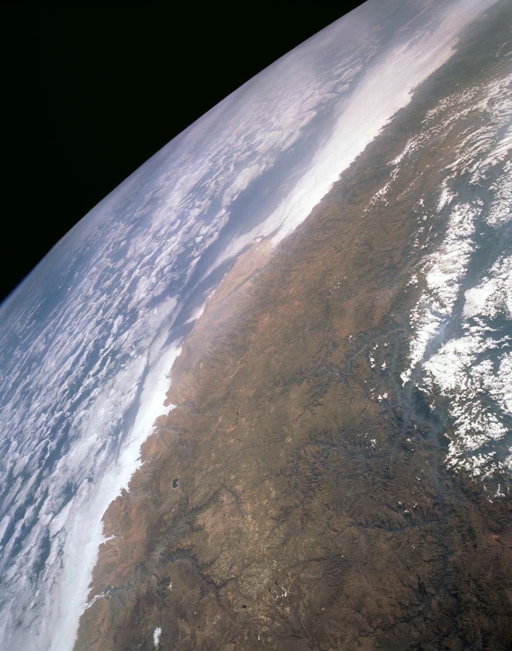
STS089-742-014 (22-31 Jan. 1998) --- This near-nadir picture of the central Andes, showing Santiago and other parts of Chile and Argentina, was photographed with a 70mm handheld camera from the Earth-orbiting space shuttle Endeavour. Santiago (population 4.7 million) is visible to the right of center, west of the snow-capped Andes Mountains. Mendoza, Argentina is the light spot in the upper center of the image in the eastern foothills of the Andes. Cerro Aconcagua, the highest peak in South America (22,834 feet) is due west of Mendoza. Note the sharp bend in the river valley to the junction with a straight north-trending valley. Aconcagua is the large, rounded mass with a bit of cloud just northwest of the valley junction. Bright white spots on the left of the image are salars, or dry lake beds of gypsum and/or salt. Usually dry, some contain water due to recent rains generated by the record El Nino this year. The Pacific Ocean is to the upper right. The continental shelf is very steep in this region and water depths drop (to almost 17,000 feet over a distance of about 60 miles) over the same distance inland from the coast, the Andes rise +17,000 to almost 23,000 feet. The reason for this is the very rapid plate motion between the Pacific Ocean plate and South America. According to NASA scientists, over the last 140 million years, South America has been overriding the Pacific plate resulting in the rapid rise in the Andes and the rapid subduction of the Pacific plate, along with any sediments that are shed into the ocean along the continental margin. The dark, linear mountain ranges east of the high Andes (right center) constitute the Precordillera block; rock strata there have been correlated with the Ordovician (approximately 470 million years old) rocks near El Paso, Texas. The rocks and the fossils within them are virtually identical in the two areas, which are now widely separated. This region would be considered a "remnant terrain" from the time when this portion of South America and Texas were once joined. Photo credit: NASA

STS091-713-024 (2-12 June 1998) --- A 70mm view, taken from Discovery, showing heavy Smoke in Mexico along the coast of the Bay of Campeche. Fires across Mexico and Central America created heavy smoke plumes for a few weeks in May and June, 1998. The smoke circulated around a high pressure system over the Gulf of Mexico and brought thick smoke and soot to the south central United States. Scientists are looking at burning regions like this around the world to study the smokes affect on the albedo or the reflectance of the suns rays and how it may influence our world's climate. The fires in this view are north of the city of Villahermosa, in the lower center or south edge of the photo. The smaller city of Cardenas is to the west of Villahermosa. The point along the coast is the Rio Grijalva river delta. Laguna de Terminos is to the east of this delta.
KENNEDY SPACE CENTER, FLA. -- A white ibis looks for food from the edge of a sunken tree in the river near Kennedy Space Center. White ibis range along the coast from South Carolina to Florida and Texas, as far as the northern area of South America. They prefer marshy sloughs, mud flats, lagoons and swamp forests. KSC shares a boundary with the Merritt Island Wildlife Nature Refuge. The refuge is a habitat for more than 310 species of birds, 25 mammals, 117 fishes and 65 amphibians and reptiles. In addition, the Refuge supports 19 endangered or threatened wildlife species on Federal or State lists, more than any other single refuge in the U.S. Photo credit: NASA/Dimitri Gerondidakis
KENNEDY SPACE CENTER, FLA. -- In the Merritt Island National Wildlife Refuge, which shares a boundary with the space center, an anhinga gets ready to eat the fish it captured in the nearby Indian River with its long, dagger-shaped bill. The bird will flip its catch into the air and gulp it down headfirst. The anhinga is also known as the "snakebird" because in the water its body is submerged so that only its head and long, slender neck are visible. Ranging the Atlantic and Gulf Coasts from North Carolina to Texas, north in the Mississippi Valley to Arkansas and Tennessee, and in the South to South America, it inhabits freshwater ponds and swamps with thick vegetation. They are often seen with wings half-open, drying them in the sun since they lack oil glands with which to preen
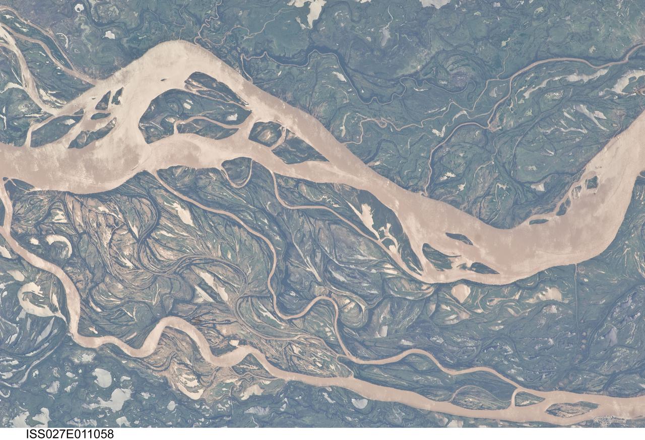
ISS027-E-011058 (9 April 2011) --- The Parana River floodplain in northern Argentina is featured in this image photographed by an Expedition 27 crew member on the International Space Station. This image shows a 29-kilometer stretch of the Parana River, South America?s second largest river, downstream of the small city of Goya (barely distinguishable as grayer surfaces in the extreme top left corner of the image). The Parana River ranges up to three kilometers wide along the reach illustrated in the image. Its strong brown color indicates that it is carrying a heavy load of muddy sediment. Smaller active side channels also carry this muddy water. Numerous lakes are typical on active floodplains, and appear here as irregular bodies of water. Some appear brown, indicating that they have been refilled during recent higher flood levels of the active channels. The main channel Parana River (top) is deep enough to allow smaller ocean-going ships to pass north of the illustrated region to the capital city of Asuncion in landlocked Paraguay, fully 1,200 kilometers inland (well out of the image). The Parana River is thus an important transportation route for landlocked cities such as Asuncion and inland cities of eastern landlocked Bolivia and inland Brazil. The Parana floodplain occupies the entire image; it is so wide?18 kilometers?that its banks are not visible. Numerous curved, or meandering past channels are the most prominent characteristic of the floodplain. These indicate prior positions of rivers. As river beds move laterally by natural processes, they leave remnants of their channels, which appear as lakes, and finally fill with mud. This is an excellent image for illustrating these meander forms. From a geological standpoint it is interesting that almost all the past channels are similar in curvature to the smaller active side rivers; almost no forms show, in any obvious way, prior positions of the main, very wide Parana channel. The reverse might be expected since the main channel is so dominant in the modern landscape.

Meandering Mississippi - May 28th, 2003 Description: Small, blocky shapes of towns, fields, and pastures surround the graceful swirls and whorls of the Mississippi River. Countless oxbow lakes and cutoffs accompany the meandering river south of Memphis, Tennessee, on the border between Arkansas and Mississippi, USA. The "mighty Mississippi" is the largest river system in North America. Credit: USGS/NASA/Landsat 7 To learn more about the Landsat satellite go to: <a href="http://landsat.gsfc.nasa.gov/" rel="nofollow">landsat.gsfc.nasa.gov/</a> <b><a href="http://www.nasa.gov/centers/goddard/home/index.html" rel="nofollow">NASA Goddard Space Flight Center</a></b> enables NASA’s mission through four scientific endeavors: Earth Science, Heliophysics, Solar System Exploration, and Astrophysics. Goddard plays a leading role in NASA’s accomplishments by contributing compelling scientific knowledge to advance the Agency’s mission. <b>Follow us on <a href="http://twitter.com/NASA_GoddardPix" rel="nofollow">Twitter</a></b> <b>Join us on <a href="http://www.facebook.com/pages/Greenbelt-MD/NASA-Goddard/395013845897?ref=tsd" rel="nofollow">Facebook</a></b>
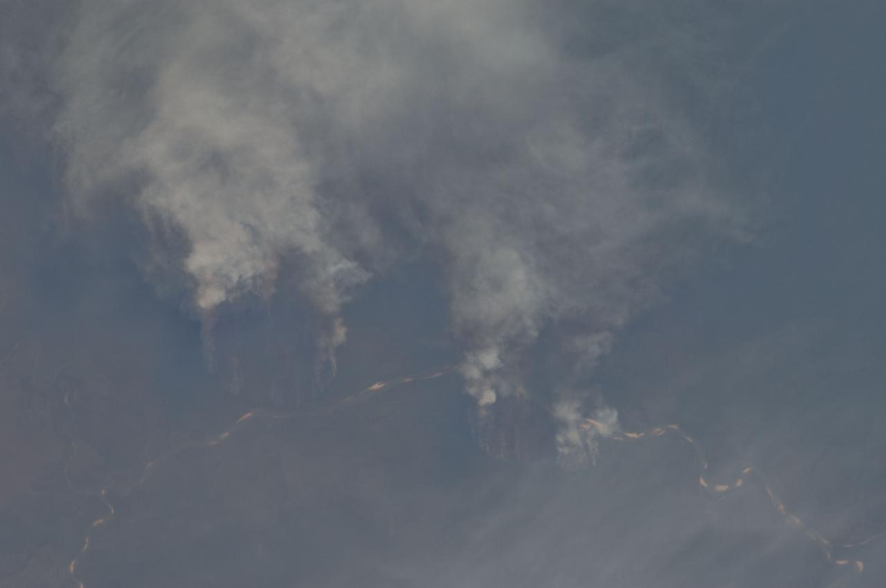
ISS029-E-008032 (17 Sept. 2011) --- Fires along the Rio Xingu, Brazil are featured in this image photographed by an Expedition 29 crew member on the International Space Station. The rain forest of South America, also known as ?Amazonia??the largest such forest on Earth?has been undergoing a continual and accelerated land use conversion process into farmlands (including pasture for livestock) since the early 1960s. This process has typically been achieved by clearing of the forest using fire ? ?slash and burn? ? followed by planting of crops. The generally infertile soils of the region make sustainable farming difficult; this drives more forest conversion into new farmland. The area of clearing can be considerable, and as the deforested regions are easily identifiable and measurable from space the rate of deforestation is likewise easy to track. This detailed photograph illustrates slash-and-burn forest clearing along the Xingu River (Rio) in the northeast of the state of Matto Grasso, Brazil. The perspective of this image allows for a striking visualization of both the horizontal position and extent of the fire lines next to the river, as well as providing a sense of the vertical structure of the smoke plumes due to the viewing angle and shadowing. Light colored areas within the river channel are sand bars, which show that the river is in its annual low-flow/ low water stage. For a sense of scale, the Xingu River channel within the view is approximately 63 kilometers long. Rivers in Amazonia are its natural highways, which may explain why the burning is occurring right next to the Xingu River, one of Amazonia?s largest. In recent years, preservation has gained traction in the region as a result of such considerations as new valuation of the ecosystem services provided by the forest, concerns about the impact of widespread burning on global climate change, and greater sensitivity to the ethnic and biological heritage of Amazonia.
ISS033-E-022378 (17 Nov. 2012) --- The Appalachian Mountains in the eastern Unites States are featured in this image photographed by an Expedition 33 crew member on the International Space Station. This regional view shows the striking visual effect of the valley-and-ridge topography of the Appalachian Mountains as viewed from orbit. The view shows more than 300 miles (500 kilometers) of this low mountain chain, from northeast Pennsylvania (lower left) to southern West Virginia, where a dusting of snow can be seen (top center). Sunglint reflections reveal detail of Chesapeake Bay and the great bend of the Potomac River. Cities are difficult to detect from space during daylight hours, so the sickle-shaped bend of the river is a good visual guide for station crew members trying to photograph the nation?s capital, Washington D.C. (upper left). The farm-dominated Piedmont Plateau is the light-toned area between the mountains and the bay. The Appalachian Mountains appear striped because the ridges are forested; providing a dense and dark canopy cover, while the valleys are farmed with crops that generally appear as lighter-toned areas. Geologically the valleys are the softer, more erodible rock layers, much the preferred places for human settlement. Not only do the larger rivers occupy the valley floors, but all the larger rivers flow in them, soils are thicker, slopes are gentle, and valleys are better protected from winter winds. According to scientists, rocks that form the valley-and-ridge province, as it is known, are relatively old (540-300 million years old), and were laid down in horizontal layers when North America was attached to Europe as the ancient supercontinent of Laurasia. During this time Gondwanaland ? an ancient supercontinent that included present-day Africa, India, South America, Australia and Antarctica - was approaching Laurasia under the influence of plate tectonics. The northwest coastline of modern Africa was the section of Gondwanaland that ?bumped up? against modern North America over a long period (320 ? 260 million years ago), according to scientists. The net result of the tectonic collision was the building of a major mountain chain, much higher than the present Appalachian range?in the process of which the flat-lying rock layers were crumpled up into a series of tight folds, at right angles to the advance of Gondwanaland. The collision also formed the singular supercontinent of Pangaea. The scientists say that, over the following 200 million years, Pangaea broke apart; the modern Atlantic Ocean formed; and erosion wore down the high mountains. What is left to see are the coastline of North America, and the eroded stumps of the mountain chain as the relatively low, but visually striking present-day Appalachian Mountains.
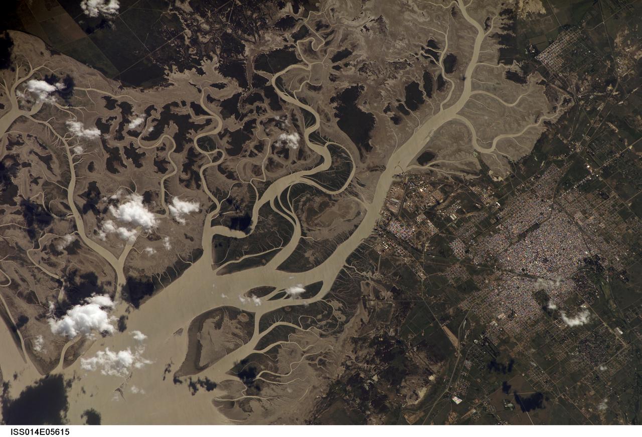
ISS014-E-05615 (14 Oct. 2006) --- Bahia Blanca, Buenos Aires Province, Argentina is featured in this image photographed by an Expedition 14 crewmember on the International Space Station. The port city of Bahia Blanca lies almost 600 kilometers southwest of Buenos Aires on the southern rim of the Argentine economic heartland. This small city of 275,000 people is captured in one frame which shows its position near the mouth of the Arroyo Naposta. The salt flats (gray) and wetlands bordering this estuary, characterized by twisting, light colored tidal channels and dark swamps, lie mainly on the south side of the river. The yellow tinge to the water surfaces arises from the partial sunglint reflection on this particular day. The name Bahia Blanca (White Bay) derives from the white color of the salt and was applied to the major bay--noted by Magellan as he probed the coast of South America for a passage to the Pacific Ocean in 1520--and then to the city at the head of this bay. Highways, airline routes and pipelines from oil and gas fields to the west and south all converge on Bahia Blanca. The city is a major cultural center and historically has acted as a gateway for immigration. Higher ground on the north side of the estuary affords stable ground for the growth of the city and for intensive agriculture, a mainstay of the Argentine economy. The city is set back from the waterfront where an industrial park, a petrochemical center, and dockyards (white ellipse) are located.
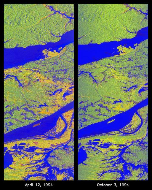
These two false-color images of the Manaus region of Brazil in South America were acquired by the Spaceborne Imaging Radar-C and X-band Synthetic Aperture Radar on board the space shuttle Endeavour. The image at left was acquired on April 12, 1994, and the image at right was acquired on October 3, 1994. The area shown is approximately 8 kilometers by 40 kilometers (5 miles by 25 miles). The two large rivers in this image, the Rio Negro (at top) and the Rio Solimoes (at bottom), combine at Manaus (west of the image) to form the Amazon River. The image is centered at about 3 degrees south latitude and 61 degrees west longitude. North is toward the top left of the images. The false colors were created by displaying three L-band polarization channels: red areas correspond to high backscatter, horizontally transmitted and received, while green areas correspond to high backscatter, horizontally transmitted and vertically received. Blue areas show low returns at vertical transmit/receive polarization; hence the bright blue colors of the smooth river surfaces can be seen. Using this color scheme, green areas in the image are heavily forested, while blue areas are either cleared forest or open water. The yellow and red areas are flooded forest or floating meadows. The extent of the flooding is much greater in the April image than in the October image and appears to follow the 10-meter (33-foot) annual rise and fall of the Amazon River. The flooded forest is a vital habitat for fish, and floating meadows are an important source of atmospheric methane. These images demonstrate the capability of SIR-C/X-SAR to study important environmental changes that are impossible to see with optical sensors over regions such as the Amazon, where frequent cloud cover and dense forest canopies block monitoring of flooding. Field studies by boat, on foot and in low-flying aircraft by the University of California at Santa Barbara, in collaboration with Brazil's Instituto Nacional de Pesguisas Estaciais, during the first and second flights of the SIR-C/X-SAR system have validated the interpretation of the radar images. http://photojournal.jpl.nasa.gov/catalog/PIA01735
KENNEDY SPACE CENTER, FLA. -- A lesser yellowleg slows for landing in a pond near Kennedy Space Center. The yellowleg is a smaller edition of the greater yellowleg, with a shorter bill. The species inhabits marshy ponds, lake and river shores, mud flats and, in the breeding season, boreal bogs. They range throughout Alaska and Canada, wintering from the southern United States throughout South America. KSC shares a boundary with the Merritt Island National Wildlife Refuge, which surrounds it. The refuge is a habitat for more than 310 species of birds, 25 mammals, 117 fishes and 65 amphibians and reptiles. In addition, the refuge supports 19 endangered or threatened wildlife species on Federal or State lists, more than any other single refuge in the U.S. Photo credit: NASA/Ken Thornsley
KENNEDY SPACE CENTER, FLA. -- A turtle cruises past a lesser yellowleg in a pond near Kennedy Space Center. The yellowleg is a smaller edition of the greater yellowleg, with a shorter bill. The species inhabits marshy ponds, lake and river shores, mud flats and, in the breeding season, boreal bogs. They range throughout Alaska and Canada, wintering from the southern United States throughout South America. KSC shares a boundary with the Merritt Island National Wildlife Refuge, which surrounds it. The refuge is a habitat for more than 310 species of birds, 25 mammals, 117 fishes and 65 amphibians and reptiles. In addition, the refuge supports 19 endangered or threatened wildlife species on Federal or State lists, more than any other single refuge in the U.S. Photo credit: NASA/Ken Thornsley
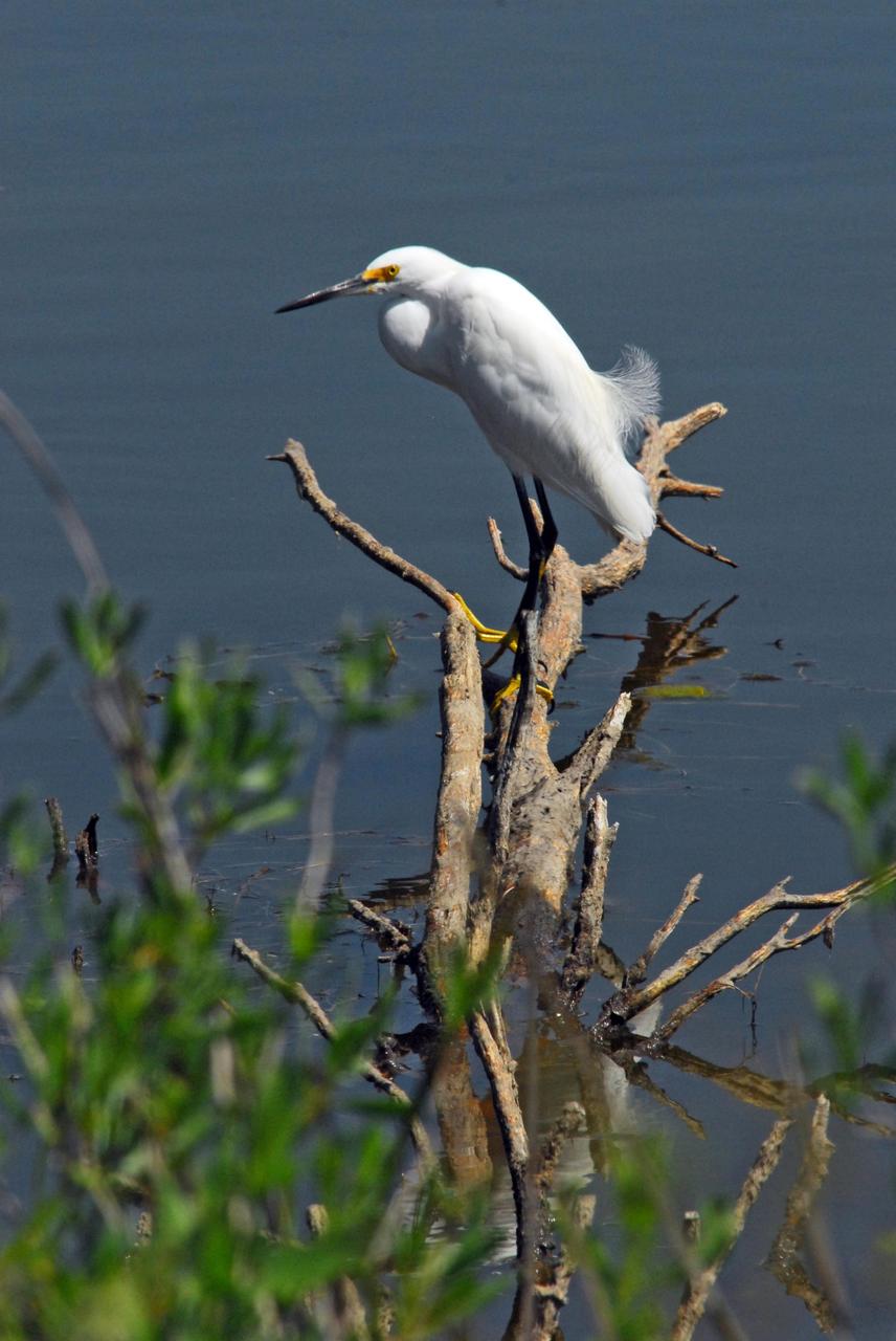
KENNEDY SPACE CENTER, FLA. -- A snowy egret perches on dead limbs in the Indian River near Kennedy Space Center. A type of heron, the snowy egret inhabits salt marshes, ponds, rice fields and shallow coastal bays ranging from Maine to southern South America on the east coast. It can also be found in California and Oklahoma to the Gulf of Mexico. KSC shares a boundary with the Merritt Island Wildlife Nature Refuge. The refuge is a habitat for more than 310 species of birds, 25 mammals, 117 fishes and 65 amphibians and reptiles. In addition, the Refuge supports 19 endangered or threatened wildlife species on Federal or State lists, more than any other single refuge in the U.S. Photo credit: NASA/Dimitri Gerondidakis
AS08-16-2588 (21-27 Dec. 1968) --- Both sides of the Atlantic Ocean are visible in this view from Apollo 8 spacecraft. (Hold picture with Earth at bottom left). The large, most prominent land mass is the bulge of West Africa. The portion of Africa near the equator is dark and cloudy, but the more northerly portions are clear, showing the prominent cape at Dakar and the Senegal River in Senegal; Cap Blanc; the Adrar Plateau in Mauretania; the wide expanse of desert in Algeria and Spanish Sahara; and the far edge, the Atlas and Anti-Atlas Mountains in Morocco. Clouds cover the eastern coast of South America, southward from Surinam and Guyana to near the city of Salvador, Brazil. The view was photographed following trans-lunar insertion.
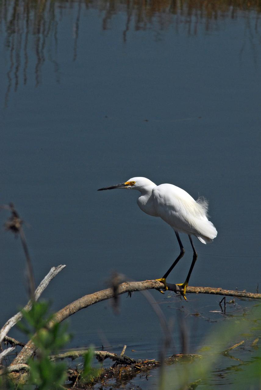
KENNEDY SPACE CENTER, FLA. -- A snowy egret perches on dead limbs in the Indian River near Kennedy Space Center. A type of heron, the snowy egret inhabits salt marshes, ponds, rice fields and shallow coastal bays ranging from Maine to southern South America on the east coast. It can also be found in California and Oklahoma to the Gulf of Mexico. KSC shares a boundary with the Merritt Island Wildlife Nature Refuge. The refuge is a habitat for more than 310 species of birds, 25 mammals, 117 fishes and 65 amphibians and reptiles. In addition, the Refuge supports 19 endangered or threatened wildlife species on Federal or State lists, more than any other single refuge in the U.S. Photo credit: NASA/Dimitri Gerondidakis
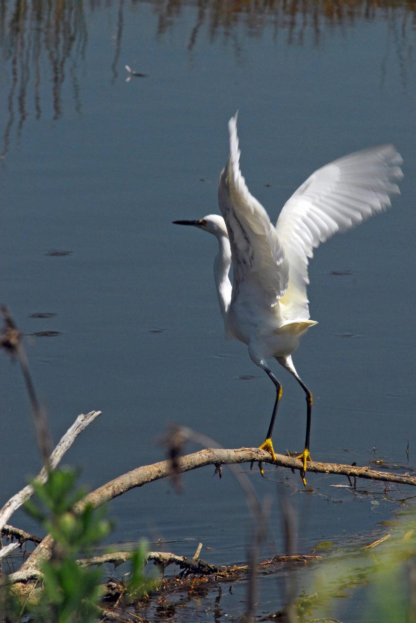
KENNEDY SPACE CENTER, FLA. -- A snowy egret prepares for flight from its perch in the Indian River near Kennedy Space Center. A type of heron, the snowy egret inhabits salt marshes, ponds, rice fields and shallow coastal bays ranging from Maine to southern South America on the east coast. It can also be found in California and Oklahoma to the Gulf of Mexico. KSC shares a boundary with the Merritt Island Wildlife Nature Refuge. The refuge is a habitat for more than 310 species of birds, 25 mammals, 117 fishes and 65 amphibians and reptiles. In addition, the Refuge supports 19 endangered or threatened wildlife species on Federal or State lists, more than any other single refuge in the U.S. Photo credit: NASA/Dimitri Gerondidakis
KENNEDY SPACE CENTER, FLA. -- Lesser yellowlegs wade through a pond near Kennedy Space Center. The yellowleg is a smaller edition of the greater yellowleg, with a shorter bill. The species inhabits marshy ponds, lake and river shores, mud flats and, in the breeding season, boreal bogs. They range throughout Alaska and Canada, wintering from the southern United States throughout South America. KSC shares a boundary with the Merritt Island National Wildlife Refuge, which surrounds it. The refuge is a habitat for more than 310 species of birds, 25 mammals, 117 fishes and 65 amphibians and reptiles. In addition, the refuge supports 19 endangered or threatened wildlife species on Federal or State lists, more than any other single refuge in the U.S. Photo credit: NASA/Ken Thornsley
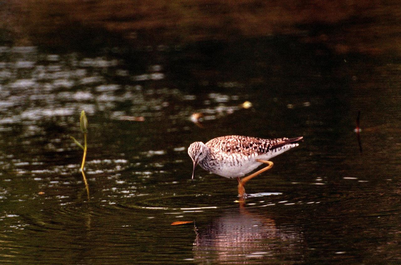
KENNEDY SPACE CENTER, FLA. -- A sandpiper-like Lesser Yellowlegs eyes the water for food in the Merritt Island National Wildlife Refuge, which shares a boundary with Kennedy Space Center. The gray-streaked wader is found in marshy ponds, lake and river shores, and mud flats in Alaska and Canada; it winters in the southern United States to southern South America. The 92,000-acre refuge is a habitat for more than 310 species of birds, 25 mammals, 117 fishes and 65 amphibians and reptiles. The marshes and open water of the refuge also provide wintering areas for 23 species of migratory waterfowl, as well as a year-round home for great blue herons, great egrets, wood storks, cormorants, brown pelicans and other species of marsh and shore birds
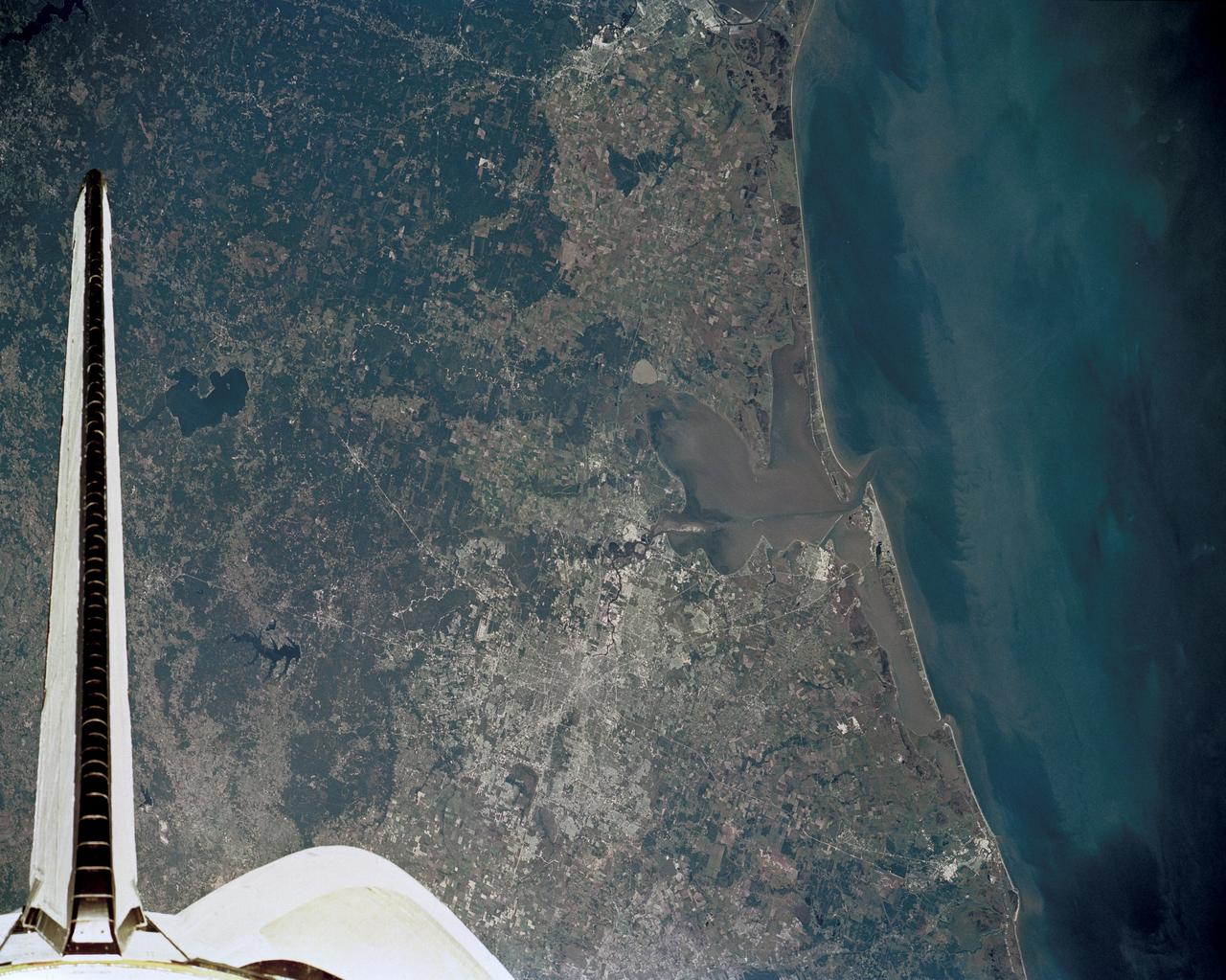
51J-143-126 (5 Oct. 1985) --- The vertical stabilizer of the Earth-orbiting Space Shuttle Atlantis serves to partially frame this scene of Metropolitan Houston. Hold photo with vertical tail at top so that north will be at top. America's fourth largest city, with its radiating highway network, lies at the junction between the East Texas piney woods, containing lakes Conroe and Livingston (near top center and top right, respectively), and the coastal prairie, now largely farmland (left side of frame). The coast stretches from the left at Freeport and the mouth of the Brazos River, past Galveston and Texas City, and the circle of the High Island Salt Dome (clearly seen at lower right near the Bolivar Peninsula), to Port Arthur on the Neches River (far right). Patterns of muddy and clear water are particularly well-displayed in Galveston and Trinity Bays, as well as in the Gulf of Mexico. With a close look, the Harris County Domed Stadium (Astrodome) can be recognized on Houston's south side. The NASA Johnson Space Center (JSC) and the Clear Lake City area are easily delineated some 25 miles southeast of downtown Houston. The scene was recorded on film by one of the STS-51J crewmembers using a handheld Hasselblad camera and 70mm film.
STS068-247-061 (30 September-11 October 1994) --- Photographed through the Space Shuttle Endeavour's flight windows, this 70mm frame centers on Yellowstone Lake in the Yellowstone National Park. North will be at the top if picture is oriented with series of sun glinted creeks and river branches at top center. The lake, at 2,320 meters (7,732 feet) above sea level, is the largest high altitude lake in North America. East of the park part of the Absaroka Range can be traced by following its north to south line of snow capped peaks. Jackson Lake is southeast of Yellowstone Park, and the connected Snake River can be seen in the lower left corner. Yellowstone, established in 1872 is the world's oldest national park. It covers an area of 9,000 kilometers (3,500 square miles), lying mainly on a broad plateau of the Rocky Mountains on the Continental Divide. It's average altitude is 2,440 meters (8,000 feet) above sea level. The plateau is surrounded by mountains exceeding 3,600 meters (12,000 feet) in height. Most of the plateau was formed from once-molten lava flows, the last of which is said to have occurred 100,000 years ago. Early volcanic activity is still evident in the region by nearly 10,000 hot springs, 200 geysers and numerous vents found throughout the park.

ISS010-E-05072 (25 October 2004) --- Ibera Swamp topography in northeast Argentina is featured in this image photographed by an Expedition 10 crewmember on the International Space Station (ISS). The central lake in this image is one of hundreds in the Ibera swamplands that were formed by South America’s second largest river, the Parana. Although this great river now lies 120 kilometers to the north, its channel has swung over a great “inland delta” in the recent geological past, according to NASA scientists studying the Expedition 10 photo collection. This and other lakes were captured in this photograph as the sunglint point passed over this remote but vast swampland in northeast Argentina. The glint pattern shows winds ruffling the water surfaces. The lakes in this image lie within side channels of the Parana formed when it flowed through this region. The central lake in the image is about 2 kilometers long. Forest, swamp and prairie vegetation types outline the low topography which consists of lakes, low swells and depressions.

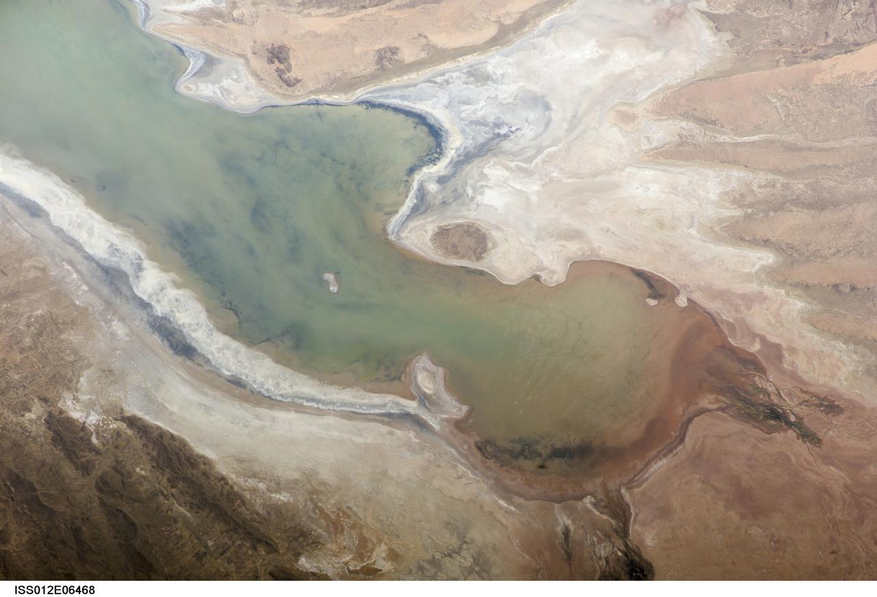
ISS012-E-06469 (3 Nov. 2005) --- A portion of Lake Poopo is featured in this image photographed by an Expedition 12 crewmember on the International Space Station. Lake Poopo sits high in the Bolivian Andes, catching runoff from its larger neighbor to the north - Lake Titicaca (not shown) - by way of the Desaguadero River (muddy area at the north end of the lake). Because Lake Poopo is very high in elevation (roughly 3400 meters or 11,000 feet above sea level), very shallow (generally less than 3 meters or 9 feet), and the regional climate is very dry, small changes in precipitation in the surrounding basin have large impacts on the water levels and areal extent of Lake Poopo. When the lake fills during wet periods, Poopo drains from the south end into Salar de Coipasa (not shown). Water levels in Poopo are important because it is one of South America’s largest saline lakes, and a prime stop for migratory birds, including flamingoes. NASA managers have tasked the station crew to track such changes, which are related to regional weather patterns. Lake Poopo’s sensitivity to precipitation in the high Andes (possibly reflecting larger climate cycles) provides an excellent visual indicator of these trends.
ISS012-E-06468 (3 Nov. 2005) --- A portion of Lake Poopo is featured in this image photographed by an Expedition 12 crewmember on the International Space Station. Lake Poopo sits high in the Bolivian Andes, catching runoff from its larger neighbor to the north - Lake Titicaca (not shown) - by way of the Desaguadero River (muddy area at the north end of the lake). Because Lake Poopo is very high in elevation (roughly 3400 meters or 11,000 feet above sea level), very shallow (generally less than 3 meters or 9 feet), and the regional climate is very dry, small changes in precipitation in the surrounding basin have large impacts on the water levels and areal extent of Lake Poopo. When the lake fills during wet periods, Poopo drains from the south end into Salar de Coipasa (not shown). Water levels in Poopo are important because it is one of South America’s largest saline lakes, and a prime stop for migratory birds, including flamingoes. NASA managers have tasked the station crew to track such changes, which are related to regional weather patterns. Lake Poopo’s sensitivity to precipitation in the high Andes (possibly reflecting larger climate cycles) provides an excellent visual indicator of these trends.
A piece of Africa—actually lots of them—began to arrive in the Americas in June 2014. On June 23, a lengthy river of dust from western Africa began to push across the Atlantic Ocean on easterly winds. A week later, the influx of dust was affecting air quality as far away as the southeastern United States. This composite image, made with data from the Visible Infrared Imaging Radiometer Suite (VIIRS) on Suomi NPP, shows dust heading west toward South America and the Gulf of Mexico on June 25, 2014. The dust flowed roughly parallel to a line of clouds in the intertropical convergence zone, an area near the equator where the trade winds come together and rain and clouds are common. In imagery captured by the Moderate Resolution Imaging Spectroradiometer (MODIS), the dust appeared to be streaming from Mauritania, Senegal, and Western Sahara, though some of it may have originated in countries farther to the east. Saharan dust has a range of impacts on ecosystems downwind. Each year, dust events like the one pictured here deliver about 40 million tons of dust from the Sahara to the Amazon River Basin. The minerals in the dust replenish nutrients in rainforest soils, which are continually depleted by drenching, tropical rains. Research focused on peat soils in the Everglades show that African dust has been arriving regularly in South Florida for thousands of years as well. In some instances, the impacts are harmful. Infusion of Saharan dust, for instance, can have a negative impact on air quality in the Americas. And scientists have linked African dust to outbreaks of certain types of toxic algal blooms in the Gulf of Mexico and southern Florida. Read more: <a href="http://1.usa.gov/1snkzmS" rel="nofollow">1.usa.gov/1snkzmS</a> NASA images by Norman Kuring, NASA’s Ocean Color web. Caption by Adam Voiland. Credit: <b><a href="http://www.earthobservatory.nasa.gov/" rel="nofollow"> NASA Earth Observatory</a></b> <b><a href="http://www.nasa.gov/audience/formedia/features/MP_Photo_Guidelines.html" rel="nofollow">NASA image use policy.</a></b> <b><a href="http://www.nasa.gov/centers/goddard/home/index.html" rel="nofollow">NASA Goddard Space Flight Center</a></b> enables NASA’s mission through four scientific endeavors: Earth Science, Heliophysics, Solar System Exploration, and Astrophysics. Goddard plays a leading role in NASA’s accomplishments by contributing compelling scientific knowledge to advance the Agency’s mission. <b>Follow us on <a href="http://twitter.com/NASAGoddardPix" rel="nofollow">Twitter</a></b> <b>Like us on <a href="http://www.facebook.com/pages/Greenbelt-MD/NASA-Goddard/395013845897?ref=tsd" rel="nofollow">Facebook</a></b> <b>Find us on <a href="http://instagram.com/nasagoddard?vm=grid" rel="nofollow">Instagram</a></b>
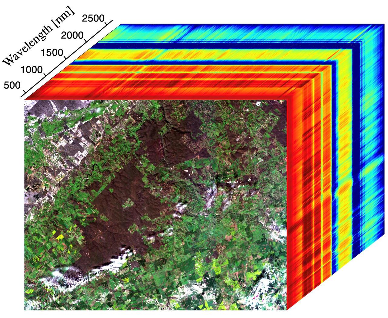
This image shows the first measurements taken by NASA's Earth Surface Mineral Dust Source Investigation (EMIT) from aboard the International Space Station at 7:51 p.m. PDT (10:51 p.m. EDT) on July 27, 2022, as it passed over western Australia. The image at the front of the cube shows a mix of materials in western Australia, including exposed soil (brown), vegetation (dark green), agricultural fields (light green), a small river, and clouds. The rainbow colors extending through the main part of the cube are the wavelengths of light (in nanometers), or spectral fingerprints, from corresponding spots in the front image. The line graph (Figure 1) shows spectral fingerprints for a sample of soil, vegetation, and a river from the image cube. Radiance indicates the amount of each wavelength of light reflected from a substance. Researchers use the combination of radiance and wavelength to determine a substance's spectral fingerprint. Developed by NASA's Jet Propulsion Laboratory in Southern California, EMIT works by measuring the hundreds of wavelengths of light reflected from materials on Earth. Different substances reflect different wavelengths of light, producing a kind of spectral fingerprint that, when collected by an imaging spectrometer and analyzed by researchers, reveal what they are made of. When science operations begin later in August 2022, EMIT's primary mission will be to collect measurements of 10 important surface minerals in regions between 50-degrees south and north latitudes in Africa, Asia, North and South America, and Australia. The minerals include hematite, goethite, illite, vermiculite, calcite, dolomite, montmorillonite, kaolinite, chlorite, and gypsum. The compositional data EMIT collects will help scientists study the role of airborne dust particles in heating and cooling Earth's atmosphere on global and regional scales. Data from EMIT will be delivered to the NASA Land Processes Distributed Active Archive Center (DAAC) for use by other researchers and the public. https://photojournal.jpl.nasa.gov/catalog/PIA24529
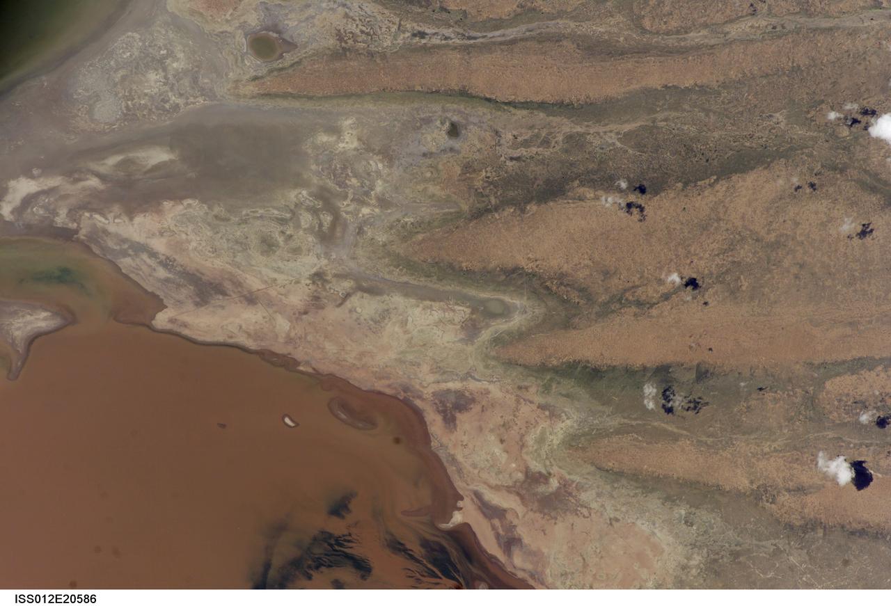
ISS012-E-20586 (9 March 2006) --- A portion of Lake Poopo is featured in this image photographed by an Expedition 12 crewmember on the International Space Station. Lake Poopo sits high in the Bolivian Andes, catching runoff from its larger neighbor to the north - Lake Titicaca (not shown) - by way of the Desaguadero River (muddy area at the north end of the lake). Because Lake Poopo is very high in elevation (roughly 3400 meters or 11,000 feet above sea level), very shallow (generally less than 3 meters or 9 feet), and the regional climate is very dry, small changes in precipitation in the surrounding basin have large impacts on the water levels and areal extent of Lake Poopo. When the lake fills during wet periods, Poopo drains from the south end into Salar de Coipasa (not shown). Water levels in Poopo are important because it is one of South America’s largest saline lakes, and a prime stop for migratory birds, including flamingoes. Last November, water levels had dropped, exposing large tracts of salt and mud flats. A wet and cool period between December and the end of February resulted in flooding of Poopo with muddy waters from the Desaguadero River. NASA managers have tasked the station crew to track such changes, which are related to regional weather patterns. Lake Poopo’s sensitivity to precipitation in the high Andes (possibly reflecting larger climate cycles) provides an excellent visual indicator of these trends.
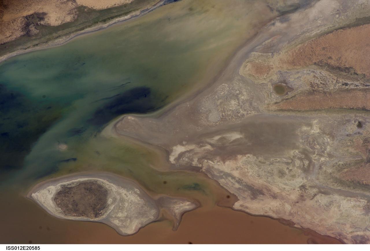
ISS012-E-20585 (9 March 2006) --- A portion of Lake Poopo is featured in this image photographed by an Expedition 12 crewmember on the International Space Station. Lake Poopo sits high in the Bolivian Andes, catching runoff from its larger neighbor to the north - Lake Titicaca (not shown) - by way of the Desaguadero River (muddy area at the north end of the lake). Because Lake Poopo is very high in elevation (roughly 3400 meters or 11,000 feet above sea level), very shallow (generally less than 3 meters or 9 feet), and the regional climate is very dry, small changes in precipitation in the surrounding basin have large impacts on the water levels and areal extent of Lake Poopo. When the lake fills during wet periods, Poopo drains from the south end into Salar de Coipasa (not shown). Water levels in Poopo are important because it is one of South America’s largest saline lakes, and a prime stop for migratory birds, including flamingoes. Last November, water levels had dropped, exposing large tracts of salt and mud flats. A wet and cool period between December and the end of February resulted in flooding of Poopo with muddy waters from the Desaguadero River. NASA managers have tasked the station crew to track such changes, which are related to regional weather patterns. Lake Poopo’s sensitivity to precipitation in the high Andes (possibly reflecting larger climate cycles) provides an excellent visual indicator of these trends.

KENNEDY SPACE CENTER, FLA. -- Coots draw together (foreground) in the waters of the Merritt Island National Wildlife Refuge, which shares a boundary with Kennedy Space Center. They are often seen in the Indian River and Banana Creek swimming together in large groups such as these. Other birds, mainly ducks, swim nearby. Coots are readily identified by their slate-gray bodies and conspicuous white bill. They inhabit open ponds and marshes from southern Canada to northern South America. Excellent swimmers and divers, they eat various aquatic plants, but also feed on seeds grass and waste grain on land. The 92,000-acre refuge is a habitat for more than 330 species of birds, 31 mammals, 117 fishes and 65 amphibians and reptiles. The marshes and open water of the refuge provide wintering areas for 23 species of migratory waterfowl, as well as a year-round home for great blue herons, great egrets, wood storks, cormorants, brown pelicans and other species of marsh and shore birds
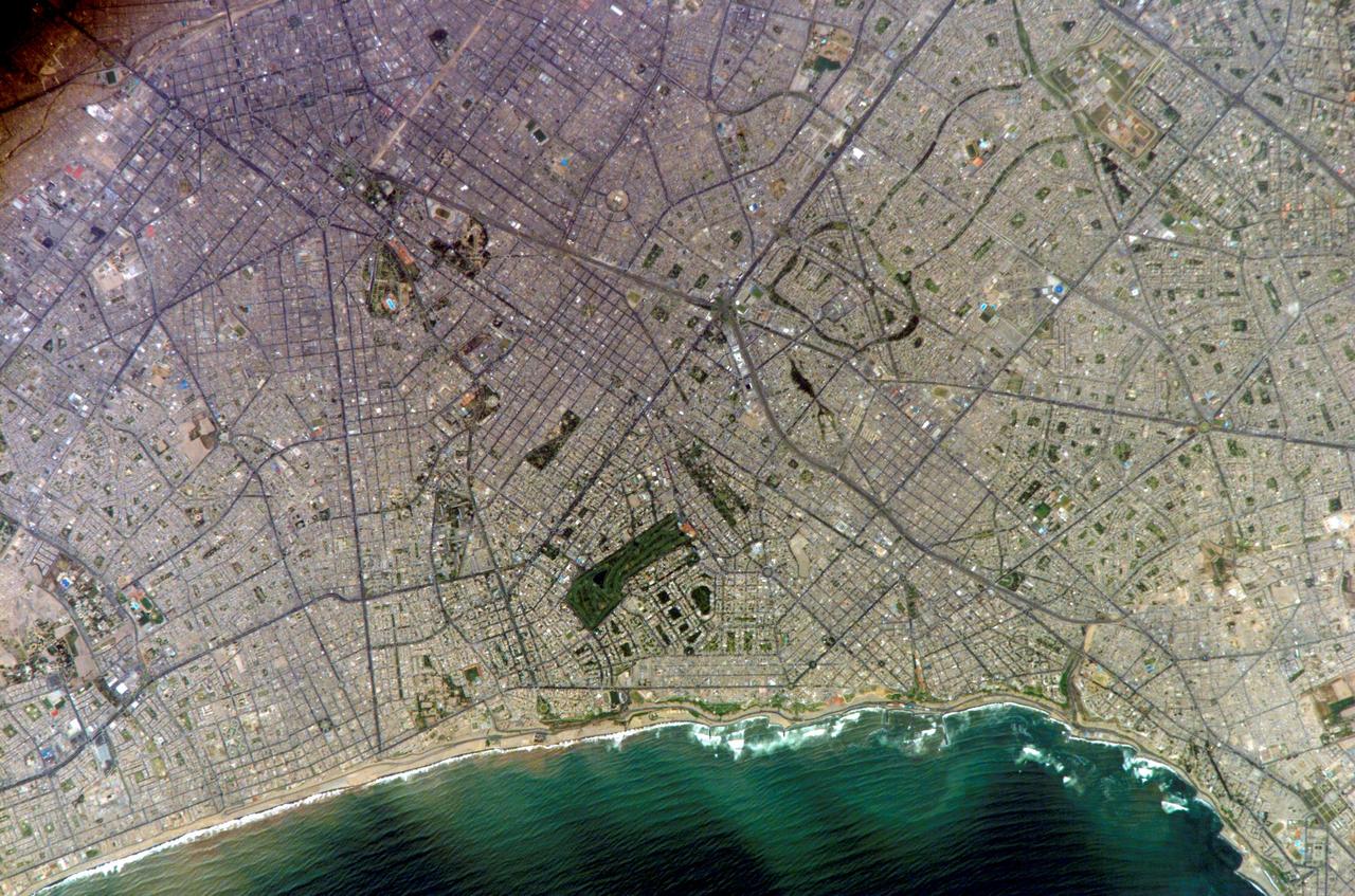
ISS010-E-20111 (15 March 2005) --- Lima, Peru is featured in this image photographed by an Expedition 10 crewmember on the International Space Station (ISS). Located on the broad alluvial fan of the Rimac River, Lima is the capital of Peru and the only mega city (7.7 million inhabitants in 2002) located on the western coastline of South America. The city was established by Francisco Pizarro in 1535 and became an important colonial port linking silver mines of the Altiplano of the high Andes to the east with the burgeoning Spanish empire. During the mid-20th century a significant relocation of people from rural mountain communities into the Lima metropolitan area led to its growth into a mega city. Problems now facing the metropolitan region include development of adequate water resources, control of pollution, and the potential effects of natural hazards such as earthquakes and landslides. This photograph depicts the wealthier San Isidro and Mira Flores quarters of Lima. This part of the metropolitan area is characterized by numerous vegetated parks, golf courses (such as the Lima Golf Course—approximately 1 kilometer long), and greenbelts interspersed with residential and commercial areas. The higher proportion of dark asphalt in the street grid of the residential and commercial areas lends a purple coloration to the left portion of the image (downtown Lima is to the north). Regions with fewer built materials and vegetation are light tan. Wave patterns are visible approaching beaches, popular tourist destinations, in the lower half of the image.
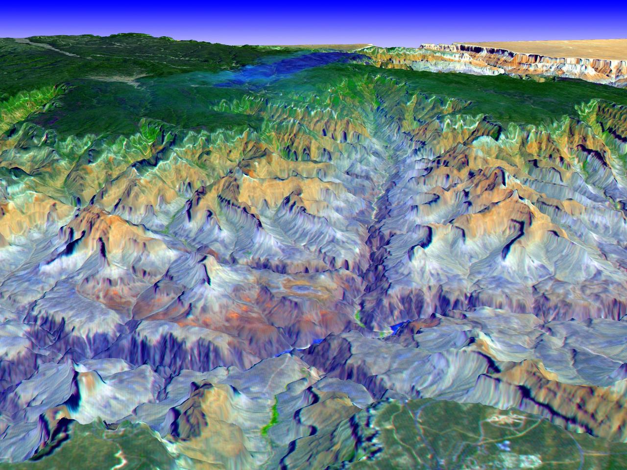
The Grand Canyon is one of North America's most spectacular geologic features. Carved primarily by the Colorado River over the past six million years, the canyon sports vertical drops of 5,000 feet and spans a 445-kilometer-long stretch of Arizona desert. The strata along the steep walls of the canyon form a record of geologic time from the Paleozoic Era (250 million years ago) to the Precambrian (1.7 billion years ago). The above view was acquired by the Advanced Spaceborne Thermal Emission and Reflection Radiometer (ASTER) instrument aboard the Terra spacecraft. Visible and near infrared data were combined to form an image that simulates the natural colors of water and vegetation. Rock colors, however, are not accurate. The image data were combined with elevation data to produce this perspective view, with no vertical exaggeration, looking from above the South Rim up Bright Angel Canyon towards the North Rim. The light lines on the plateau at lower right are the roads around the Canyon View Information Plaza. The Bright Angel Trail, which reaches the Colorado in 11.3 kilometers, can be seen dropping into the canyon over Plateau Point at bottom center. The blue and black areas on the North Rim indicate a forest fire that was smoldering as the data were acquired on May 12, 2000. http://photojournal.jpl.nasa.gov/catalog/PIA02668
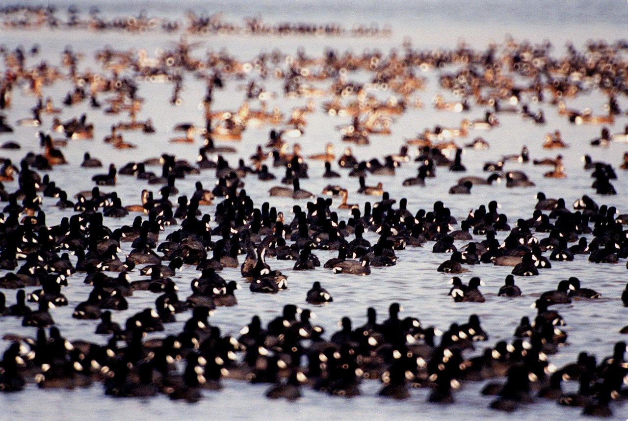
KENNEDY SPACE CENTER, FLA. -- Coots draw together (foreground) in the waters of the Merritt Island National Wildlife Refuge, which shares a boundary with Kennedy Space Center. They are often seen in the Indian River and Banana Creek swimming together in large groups such as these. Other birds, mainly ducks, swim nearby. Coots are readily identified by their slate-gray bodies and conspicuous white bill. They inhabit open ponds and marshes from southern Canada to northern South America. Excellent swimmers and divers, they eat various aquatic plants, but also feed on seeds grass and waste grain on land. The 92,000-acre refuge is a habitat for more than 330 species of birds, 31 mammals, 117 fishes and 65 amphibians and reptiles. The marshes and open water of the refuge provide wintering areas for 23 species of migratory waterfowl, as well as a year-round home for great blue herons, great egrets, wood storks, cormorants, brown pelicans and other species of marsh and shore birds
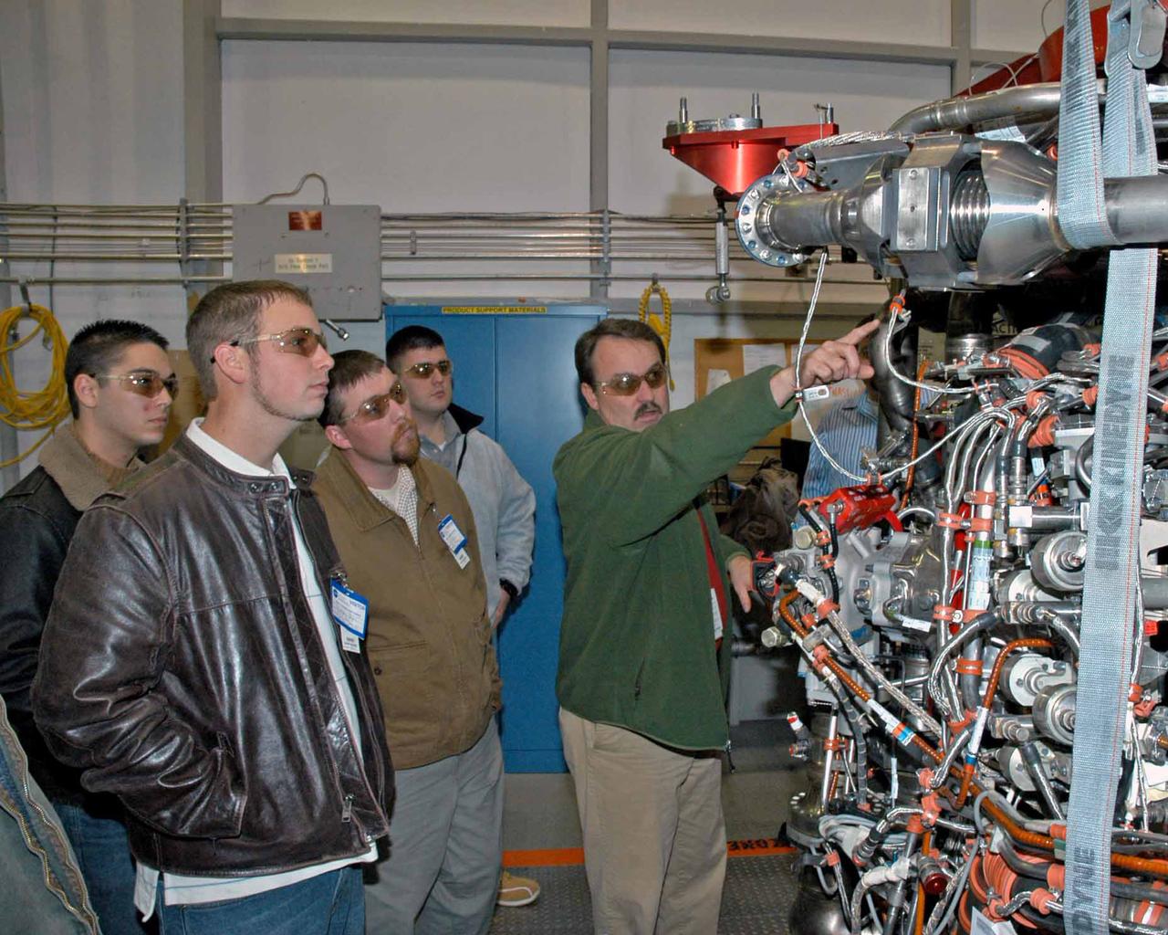
Pratt & Whitney Rocketdyne's Jeff Hansell, right, explains functions of a space shuttle main engine to Pearl River Community College Aviation Maintenance Technology Program students. Christopher Bryon, left, of Bay St. Louis, Ret Tolar of Kiln, Dan Holston of Baxterville and Billy Zugg of Long Beach took a recent tour of the SSME Processing Facility and the E-1 Test Complex at Stennis Space Center in South Mississippi. The students attend class adjacent to the Stennis International Airport tarmac in Kiln, where they get hands-on experience. PRCC's program prepares students to be responsible for the inspection, repair and maintenance of technologically advanced aircraft. A contractor to NASA, Pratt & Whitney Rocketdyne in Canoga Park, Calif., manufactures the space shuttle main engine and its high-pressure turbo pumps. SSC was established in the 1960s to test the huge engines for the Saturn V moon rockets. Now 40 years later, the center tests every main engine for the space shuttle, and is America's largest rocket engine test complex. SSC will soon begin testing the rocket engines that will power spacecraft carrying Americans back to the moon and on to Mars.
STS047-151-488 (12 - 20 Sept 1992) --- In this large format camera image, the forested Cascade Range appears along the left side; the Pacific Ocean, on the right. The frame was photographed as the Space Shuttle Endeavour flew north to south over Vancouver and Seattle. Many peaks in the Cascades reach altitudes greater than 9,000 feet and remain snowcapped even in mid-summer. The Strait of Juan de Fuca separates the Olympic Peninsula (top right) from Vancouver Island (bottom right). Snowcapped Mt. Olympus (7,965 feet) is one of the wettest places in the continental United States, with rainfall in excess of 120 inches per year. The port cities of Seattle and Tacoma occupy the heavily indented coastline of Puget Sound (top center). They appear as light-colored areas on the left side of the Sound. The angular street pattern of Tacoma is visible at the top of the picture. The international boundary between Canada and the United States of America runs across the middle of the view. The city of Victoria (center) is the light patch on the tip of Vancouver Island. Canada's Fraser River Delta provides flat topography on which the cities of Vancouver, Burnaby, and New Westminster were built. These cities appear as the light-colored area just left of center. The Fraser River can be seen snaking its way out of the mountains at the apex of the delta. Numerous ski resorts dot the slopes of the mountains (bottom left) that rise immediately to the north of Vancouver. In the same area the blue water of Harrison and other, smaller lakes fills some of the valleys that were excavated by glaciers in the "recent" geological past, according to NASA scientists studying the photography. A Linhof camera was used to expose the frame.
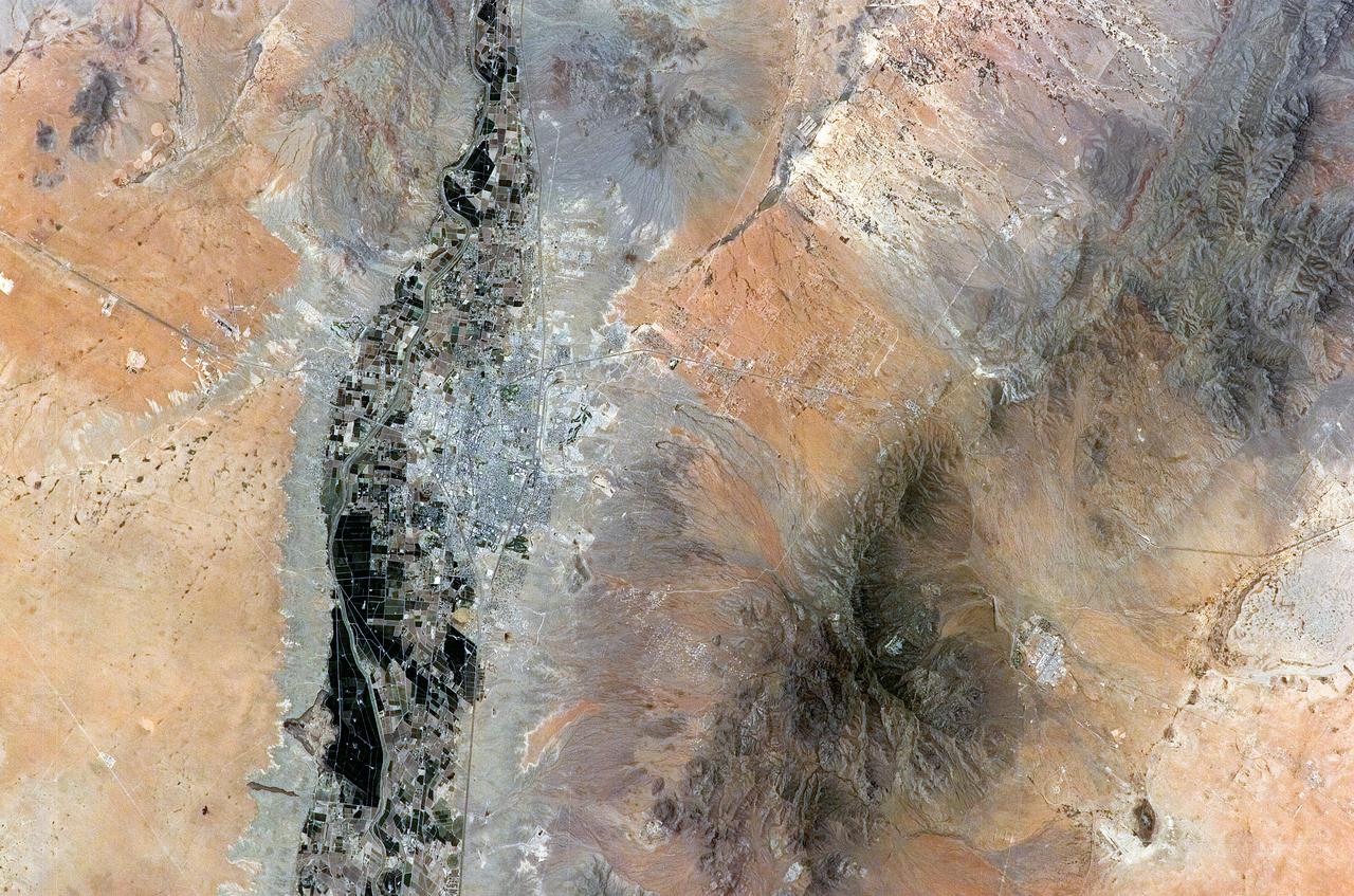
ISS011-E-08410 (9 June 2005) --- Las Cruces, New Mexico is featured in this image photographed by an Expedition 11 crewmember on the International Space Station. The city of Las Cruces is located within the Rio Grande Rift, a large geological feature that extends from Colorado southward into Mexico. According to NASA geologists, rifting usually heralds the breakup of continental landmasses, such as the separation of South America and Africa to form the southern Atlantic Ocean during the Mesozoic Era. The Rift is marked by a series of depressions (known as graben) caused by the subsidence of crustal blocks between parallel faults as the continental crust is pulled apart by tectonic forces. These graben are frequently marked by uplifted rocks along bounding faults — the striking Organ Mountains to the east of Las Cruces are one such uplifted fault block. While separation of the continental crust is no longer occurring, the Rio Grande Rift is still considered active as evidenced by frequent low-intensity earthquakes and hot springs to the north of Las Cruces. The modern city of Las Cruces — the seat of Doña Ana County and home to New Mexico State University — is undergoing rapid urban expansion due to influx of new residents attracted to the climate and landscape. The current urban area (gray to white region at image center) contrasts sharply with agricultural lands (dark green and grey brown) located along the Rio Grande River and the surrounding desert valley floor to the northeast and southwest (brown, blue gray and tan areas).
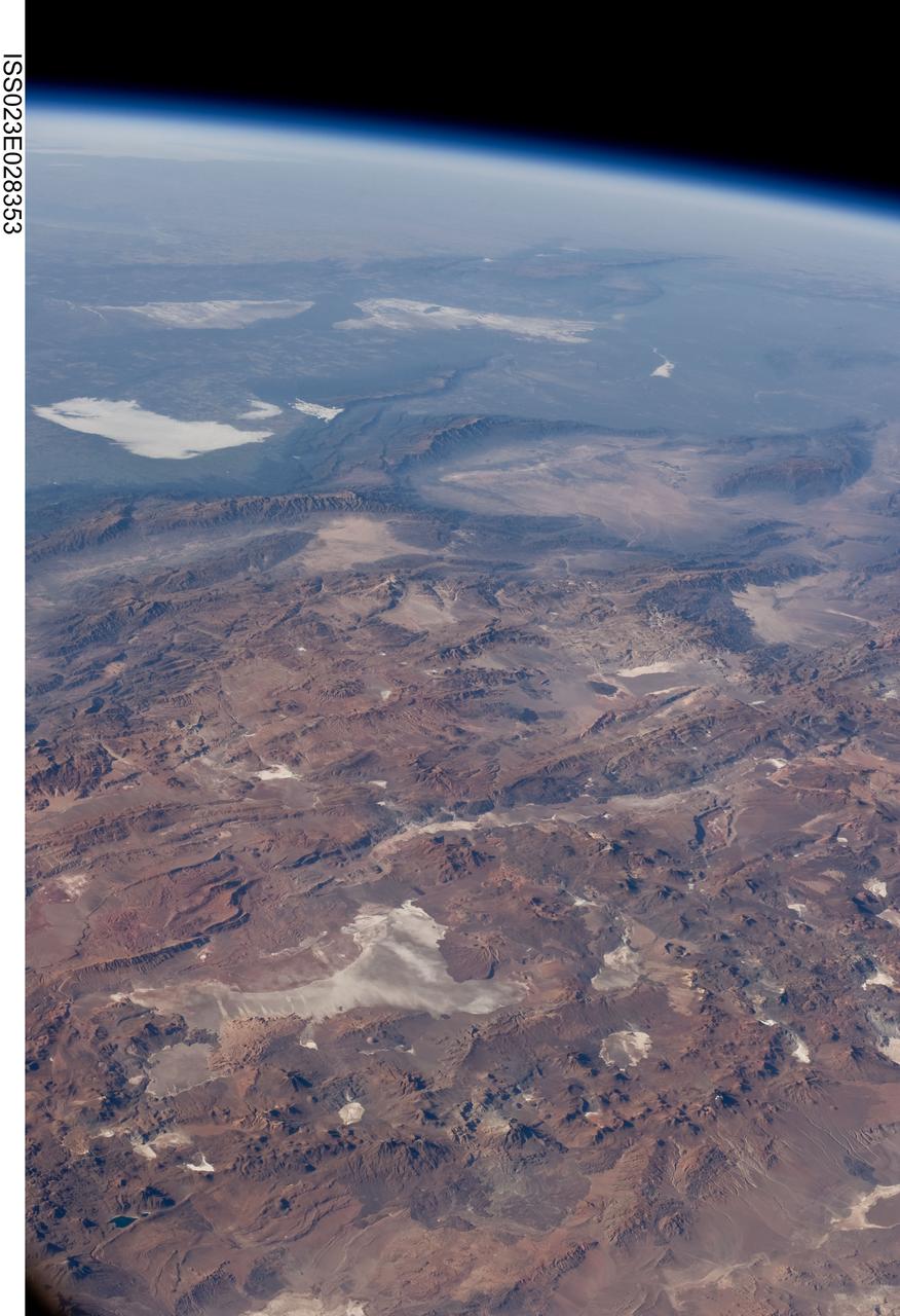
ISS023-E-028353 (26 April 2010) --- Central Andes Mountains, Salar de Arizaro, Argentina are featured in this image photographed by an Expedition 23 crew member on the International Space Station. The high plains (3,000 to greater than 5,000 meters elevation, 13,000 to 19,000 feet) of the Andes Mountains, also known as the Puna, appear in the foreground of this photograph, with a line of young volcanoes facing the much lower Atacama Desert (1,000–2,000 meters elevation). Several large dry lakes, marked by light-toned salt crusts, occupy the basins between major thrust faults in the Puna. Salar de Arizaro (foreground) is the largest of the dry lakes in this view (salar means waterless salt flat in Spanish). This panorama was taken by a station crew member looking southeast across the South American continent when the ISS was almost directly over the Atacama Desert near Chile’s Pacific coast. The Atlantic Ocean coastline (River Plate where Argentina’s capital city of Buenos Aires is located) is dimly visible at top left. A striking geological and landscape contrast is visible at center which separates two distinct geological zones, namely the Puna and the Sierras Pampeanas. The Sierras Pampeanas Mountains are lower in elevation and have few young volcanoes, in contrast to the Puna. Sharp-crested ranges are separated by wide, low valleys in this region. The Salinas Grandes—ephemeral shallow salt lakes at top left (salina means salt lake in Spanish) — occupies one of these valleys. The general color change from reds and browns in the foreground to blues and greens in the upper part of the image reflects the major climatic regions, namely the deserts of the Atacama and Puna, versus the low grassy plains of central Argentina where rainfall is sufficient to promote lush prairie grass growth—known famously as the pampas in Argentina. The Salinas Grandes mark an intermediate semiarid region. What accounts for the changes in landscape? The geology of this part of the Andes is a result of the eastward subduction of the Nazca tectonic plate underneath South America. Investigations using seismic data suggest that the Puna is underlain by a steeply dipping sector of the subducting Nazca plate. The Sierras Pampeanas zone however, is underlain by a sector of the Nazca plate that is almost horizontal, possibly due to the subduction of a submarine mountain range known as the Juan Fernandez Ridge. In the simplest terms, ridges are topographic highs that are difficult to stuff down subduction zones, with profound effects on the volcanism and structures of the upper plate.