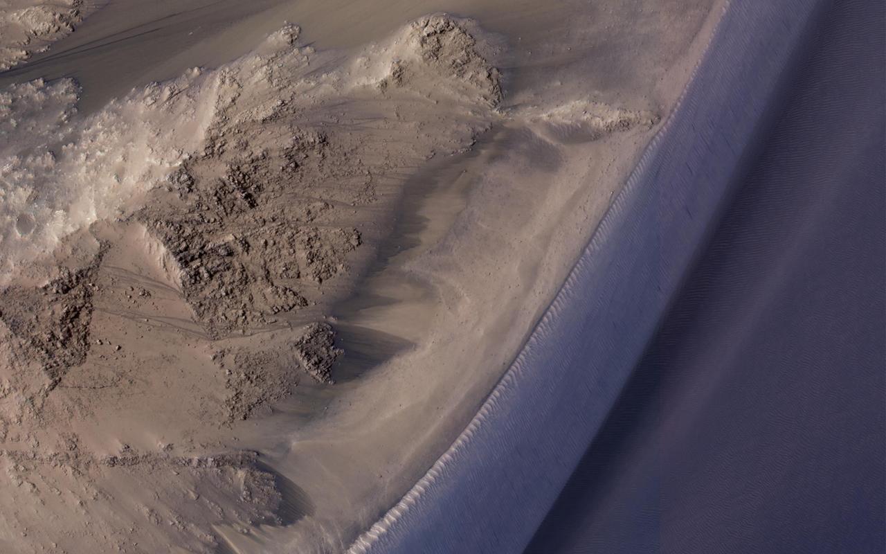
![Recurring Slope Lineae (called "RSL") are seasonally-repeating dark flows that are active at the warmest times of the year. Some of these grow from the top of the steep slope downwards as expected for liquid or granular flows. Others show different darkening patterns, which suggests different processes. Although HiRISE has acquired many images to monitor RSL sites, it still is not certain how these features form. The map is projected here at a scale of 25 centimeters (9.8 inches) per pixel. [The original image scale is 25.8 centimeters (10.2 inches) per pixel (with 2 x 2 binning); objects on the order of 51.7 centimeters (20.4 inches) across are resolved.] North is up. http://photojournal.jpl.nasa.gov/catalog/PIA21558](https://images-assets.nasa.gov/image/PIA21558/PIA21558~medium.jpg)
Recurring Slope Lineae (called "RSL") are seasonally-repeating dark flows that are active at the warmest times of the year. Some of these grow from the top of the steep slope downwards as expected for liquid or granular flows. Others show different darkening patterns, which suggests different processes. Although HiRISE has acquired many images to monitor RSL sites, it still is not certain how these features form. The map is projected here at a scale of 25 centimeters (9.8 inches) per pixel. [The original image scale is 25.8 centimeters (10.2 inches) per pixel (with 2 x 2 binning); objects on the order of 51.7 centimeters (20.4 inches) across are resolved.] North is up. http://photojournal.jpl.nasa.gov/catalog/PIA21558
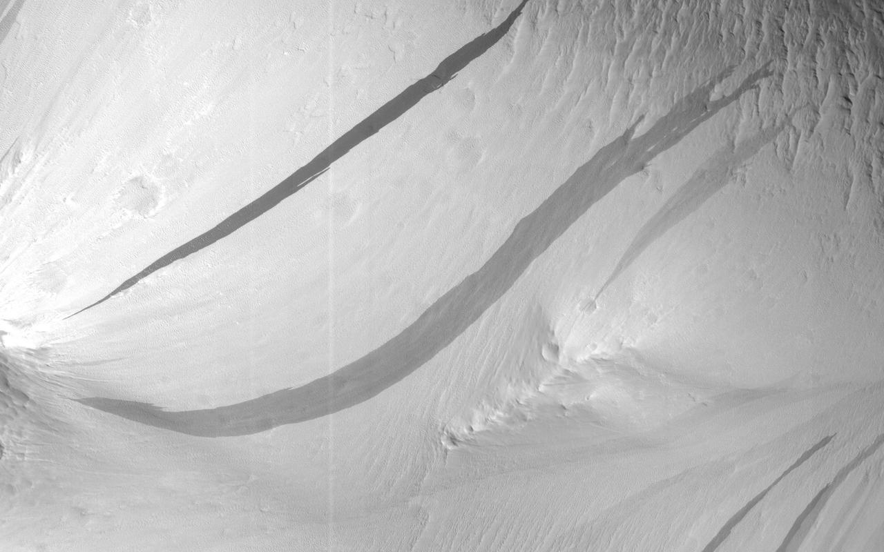
The image shows a region we see many slope streaks, typically dark features on slopes in the equatorial regions on Mars. They may extend for tens of meters in length and gradually fade away with time as new ones form. The most common hypothesis is that they are generated by dust avalanches that regularly occur on steep slopes exposing fresh dark materials from underneath the brighter dust. There are many types of slope streaks but one of the most recent and significant findings using HiRISE was the discovery of a new type called "recurring slope lineae," or RSL for short. Recent studies suggest that RSL may form through the flow of briny (extremely salty) liquid water that can be stable on the surface of Mars even under current climatic conditions for a limited time in summer when it is relatively warm. How can we distinguish between conventional slope streaks like the ones we see here and RSL? There are many criteria. For instance, RSL are usually smaller in size than regular slope streaks. However, one of the most important conditions is seasonal behavior, since RSL appear to be active only in summer while regular slope streaks can be active anytime of the year. This site is monitored regularly by HiRISE scientists because of the high density of slope streaks and their different sizes and orientations. If we look at a time-lapse sequence, we will see that a new slope streak has indeed formed in the period since April 2016 (and we can note how dark it is in comparison to the others indicating its freshness). However, this period corresponds mainly to the autumn season in this part of Mars, whereas we do not see any major changes in the summer season. This suggests that the feature that developed is a regular slope streak just like all the others in the area. http://photojournal.jpl.nasa.gov/catalog/PIA21272

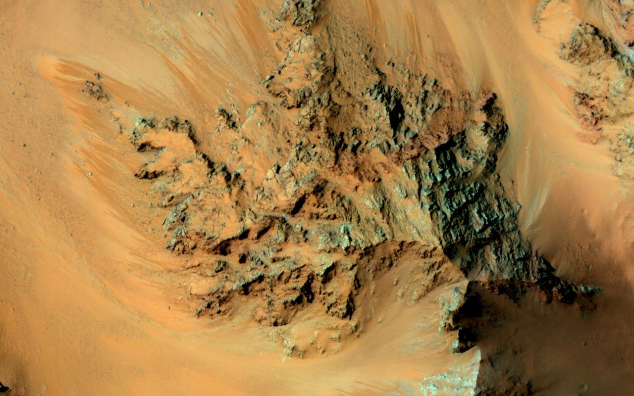
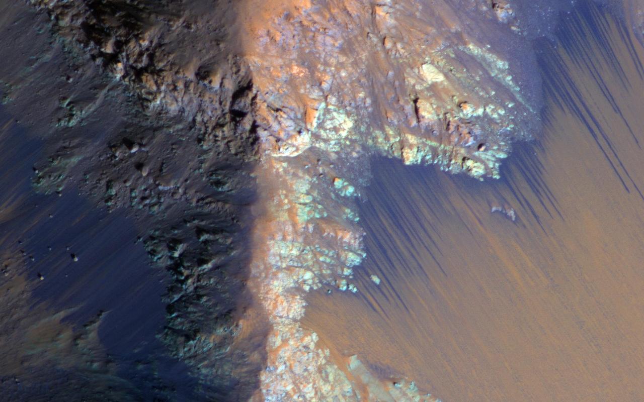
This image from NASA's Mars Reconnaissance Orbiter covers a steep west-facing slope in southwestern Ganges Chasma, north of the larger canyons of Valles Marineris. The spot was targeted both for the bedrock exposures and to look for active slope processes. We see two distinct flow deposits: lobate flows that are relatively bright, sometimes with dark fringes, and very thin brownish lines that resemble recurring slope lineae (or 'RSL'). Both flows emanate from rocky alcoves. The RSL are superimposed on the lobate deposits (perhaps rocky debris flows), so they are younger and more active. The possible role of water in forming the debris flows and RSL are the subjects of continuing debate among scientists. We will acquire more images here to see if the candidate RSL are active. https://photojournal.jpl.nasa.gov/catalog/PIA21651
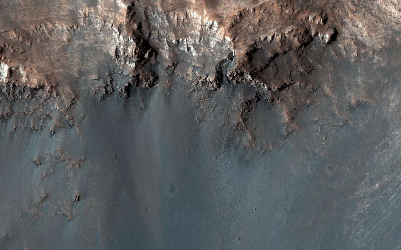
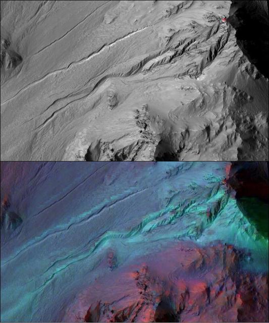
This inner slope of a crater on southern Mars has several of the seasonal dark streaks called "recurrent slope lineae," or RSL, that a November 2017 report interprets as granular flows, rather than darkening due to flowing water. This 2011 view near the top of the southern rim of Tivat Crater comes from the High Resolution Imaging Science Experiment (HiRISE) camera on NASA's Mars Reconnaissance Orbiter. North is toward the top and the slope descends toward the northwest. The view spans an area about 1,000 feet (300 meters) wide. Figure 1 includes a scale bar of 50 meters (164 feet). HiRISE began viewing Mars in 2006. Multiple observations of some sites resulted in discovery of RSL in 2011 and has confirmed many thousands of them at more than 50 sites, from equatorial to mid-latitude north and south. These narrow, dark features appear in warm seasons, gradually extend downslope, fade away in winter and reappear the next year. On Earth, only seeping water is known to have these behaviors. Hydrated salts have been identified at RSL sites and RSL have previously been considered possible evidence of liquid water seeping down the slopes and darkening the ground. The Nov. 20, 2017, report in Nature Geosciences uses analysis of the steepness of slopes where RSL appear, including these RSL at Tivat Crater. The RSL all end, downhill, at approximately the same slope, which is similar to the angle of repose for sand. That is, the flows do not extend to slopes shallower than where dry grains of sand or dust could slip downhill, as on the face of a dune. Seeping water should readily extend to shallower slopes. This image is an excerpt from HiRISE observation ESP_023184_1335, taken on July 8, 2011, during Martian mid-afternoon at this site, at latitude 45.9 degrees south and longitude 9.5 degrees east. Tivat Crater is about 2.2 miles (3.6 kilometers) in diameter, and was named in 2011 for a town in Montenegro. https://photojournal.jpl.nasa.gov/catalog/PIA22070
This unnamed, approximately 30-kilometer diameter crater, formed in the Southern highlands of Mars. This image from NASA's Mars Reconnaissance Orbiter shows regions of geologic diversity within, making this an interesting spot for scientists to study how different Martian processes interact with each other. Gullies, or channels formed by fluids such as water or lava, cut into the rim and sides of this crater. The presence of gullies can reveal clues about the ancient history of Mars, such as the amount of flowing fluid needed to form them and roughly how long ago that happened. This crater may also host features actively changing on the surface of Mars known as "recurring slope lineae" (RSL). Manifesting as dark streaks on steep slopes such as the walls of craters, scientists posit briny flows of small volumes of water as a possible RSL formation method. Studying the behavior of RSL further may provide evidence for the presence of water on Mars today. Moving toward the crater floor, one can observe patterns indicative of dunes. Dunes arise from the breakdown of exposed rocks by wind and subsequent manipulation of the eroded sand particles into wave-like structures. The presence of dust devil tracks provides additional evidence for significant wind activity at this location. These dunes are very dusty and so likely haven't been active (moved) in some time. HiRISE also captured a small, relatively fresh crater on the floor near the dunes. One of the most ubiquitous processes in the solar system, impact cratering can drastically change the surface of a planetary body. As such, craters provide sources of comparison between planets, moons, and other bodies across the solar system. Impacts still occur today, helping scientists find relative ages of different areas of a planet and discover materials buried under the surface. All of these processes have altered the surface of Mars in the past and continue to do so today. Since gully formation, wind erosion, and impact cratering could have interacted with each other for many years, planetary scientists find it difficult to work backwards and make definitive statements about ancient Martian history. However, HiRISE imagery has aided in closing these gaps in our scientific knowledge. https://photojournal.jpl.nasa.gov/catalog/PIA21654
This image from NASA Mars Reconnaissance Orbiter covers Raga Crater, the location of well-studied recurring slope lineae RSL. RSL are dark flows that disappear and re-form every Mars year at certain locations. http://photojournal.jpl.nasa.gov/catalog/PIA19309
Recurring slope lineae (RSL) are seasonal flows on warm slopes, and are especially common in central and eastern Valles Marineris, as seen in this observation by NASA's Mars Reconnaissance Orbiter (MRO). This image covers a large area full of interesting features. Here, the RSL are active on east-facing slopes, extending from bouldery terrain and terminating on fans. Perhaps the fans themselves built up over time from the seasonal flows. Part of the fans with abundant RSL are dark, while the downhill portion of the fans are bright. The role of water in RSL activity is a matter of active debate. https://photojournal.jpl.nasa.gov/catalog/PIA21608
Existing images of this impact crater show a couple of dark lineations on the equator-facing wall that resemble small recurring slope lineae (RSL). However, unlike typical RSL, these lines persist for several Mars years with only minor changes. https://photojournal.jpl.nasa.gov/catalog/PIA23854
The formation of recurring slope lineae is a fascinating process on Mars. These RSLs show up in the spring and fade in the winter as seen by NASA Mars Reconnaissance Orbiter.
Ravines or very large gullies are actively forming on Mars during the coldest times of year, when carbon dioxide frost aids mass wasting as seen by NASA Mars Reconnaissance Orbiter. However, some of these ravines also show activity in the warmest time of year, in the form of recurring slope lineae (RSL); dark, narrow flows in some alcoves that flow part way down the channels. Few topographic changes have been seen in association with RSL, and they appear to be seeps of water that seasonally extend down slopes, then fade when inactive, and recur each warm season. Could the RSL activity carve the ravines? In some places the RSL extend to the ends of the fans and appear to match in scale, and perhaps gradually form the ravines. In other places, such as this image, the ravines are much larger than the RSL, so presently-observed RSL flow did not produce the larger landforms, but maybe the flow was greater in the past or maybe the RSL just follow the topography created by other processes. The largest ravines are on pole-facing slopes in the middle latitudes, where RSL have never been seen to form, unless the ravine creates a small equator-facing slope. http://photojournal.jpl.nasa.gov/catalog/PIA19458
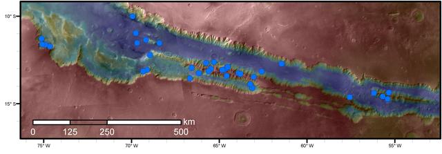
Blue dots on this map indicate sites of recurring slope lineae (RSL) in part of the Valles Marineris canyon network on Mars. RSL are seasonal dark streaks regarded as the strongest evidence for the possibility of liquid water on the surface of modern Mars. The area mapped here has the highest density of known RSL on the Red Planet. The RSL were identified by repeated observations of the sites using the High Resolution Imaging Science Experiment (HiRISE) camera on NASA's Mars Reconnaissance Orbiter. Map colors represent elevation, where red is high and blue is low. Valles Marineris is the largest canyon system in the solar system. The region shown here includes Melas Chasma and Coprates Chasma, in the central and eastern portions of Valles Marineris. The mapped area extends about 1,500 miles (2,400 kilometers) east to west and about 280 miles (450 kilometers) north to south, at latitudes from 9 to 17 degrees south of Mars' equator. The base map uses data from the Mars Orbiter Camera and Mars Orbiter Laser Altimeter of NASA's Mars Global Surveyor mission. RSL extend downslope during a warm season, fade in the colder part of the year, and repeat the process in a subsequent Martian year. A study of 41 RSL sites in this canyon area, published July 7, 2016, provides support for the notion that significant amounts of near-surface water can be found on modern Mars, though the work also indicates that puzzles remain unsolved in understanding how these seasonal features form. Each site includes anywhere from a few to more than 1,000 individual "lineae." http://photojournal.jpl.nasa.gov/catalog/PIA20756
Recurring slope lineae are active flows on warm Martian slopes that might be caused by seeping water. One of the most active sites known is in the central peaks of Hale Crater as seen by NASA Mars Reconnaissance Orbiter. This image shows RSL extending downhill from bedrock cliffs, mostly towards the northwest (upper left). This image was acquired in middle summer when RSL are most active in the southern mid latitudes. The RSL in Hale have an unusually "reddish" color compared to most RSL, perhaps due to oxidized iron compounds, like rust. Since HiRISE color is shifted to infra-red wavelengths, they are actually especially bright the near-infrared just beyond the range of human vision. The Hale RSL are also unusual because they began activity much earlier than most RSL sites in the middle southern latitudes, and were well-developed in the early spring (see ESP_038073_1440). If seeping water causes RSL in Hale crater, it must be rich in salts to lower its freezing point significantly below the freezing point of pure water. http://photojournal.jpl.nasa.gov/catalog/PIA19359
This image shows some faint traces of dark flows along the headwall of an impact crater. These are relics of seasonal recurring slope lineae (RSL) that formed on an equator-facing slope. They are not expected to be active yet, so we'll have to wait until later in the Martian spring for any changes. However, we like to monitor these sites as they progress through the seasons, and fully formed RSL have been identified at this site before. That's because RSL recur each Mars year at the same places, like this crater wall. RSL activity often happens at predicted temperatures approaching minus 20 degrees Celsius (or minus 4 degrees Fahrenheit). An intermittent flow of brines is possible but dry flow of granules is an alternative explanation to explain RSL formation. Because of this uncertainty, the science community is debating whether these regions should be regarded as "special regions" where rovers or others landers are restricted. https://photojournal.jpl.nasa.gov/catalog/PIA23951
Dark, seasonal flows emanate from bedrock exposures at Palikir Crater on Mars in this image from the HiRISE camera on NASA Mars Reconnaissance Orbiter. These dark, warm-season flows are called recurring slope lineae or RSL.
Recurring slope lineae RSL may be due to active seeps of water. These dark flows are abundant along the steep slopes of ancient bedrock in Coprates Chasma as seen in this image from NASA Mars Reconnaissance Orbiter.
NASA Mars Reconnaissance Orbiter observes the southeast rim of Hale Crater, about 150 kilometers 90 miles in diameter and located in the mid-southern latitudes just north of the massive Argyre basin. RSL are often found on northwest-facing slopes, and they occur in the central peak of Hale. During the season when we know RSL appear, this observation at high resolution might help us see if they occur elsewhere. http://photojournal.jpl.nasa.gov/catalog/PIA19176
Seasonal flows called recurring slope lineae RSL grow down warm slopes in the summer, fade when they become inactive, then re-form the following year when the slopes warm up again from the Sun. This observation is from NASA Mars Reconnaissance Orbiter
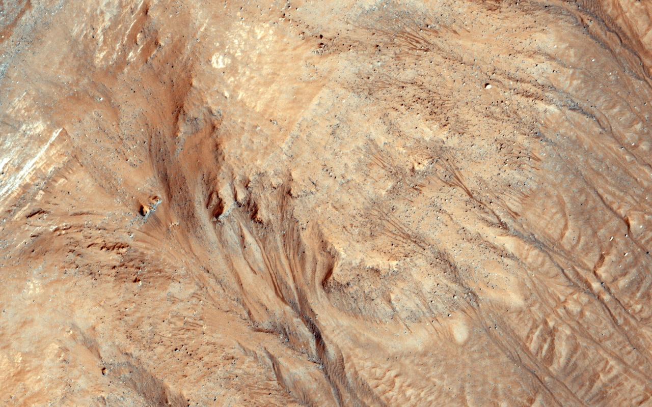
This image was acquired in Ius Chasma, a major section of the western portion of the giant Valles Marineris trough. We see a portion of a steep slope with gullies extending downhill (towards bottom of image). Many of the gully floors are dark, and in some places that dark material extends onto the fan-shaped deposits of the gullies. These dark features are candidates for recurring slope lineae (RSL), which are seasonal features that grow incrementally. The relation between RSL and gullies is not clear: does the RSL activity carve the gullies, or do they simply follow the gully topography created by other processes? Another closeup from this observation shows part of the floor of Ius Chasma, with layered bedrock draped by dunes. https://photojournal.jpl.nasa.gov/catalog/PIA23099
This image from NASA Mars Reconnaissance Orbiter shows some striking dark downslope flows in Aram Chaos. Since this is a dark, low-dust setting, these are probably not slope streaks (which form in bright dusty areas). This image can provide us with another look, particularly in order to detect any changes. Recurring slope lineae (RSL) are another type of dark streak seen on Martian slopes and are thought to form from flow of liquid water. Do these streaks behave like RSL? Additional images such as this one allow us to test whether these streaks grow seasonally and recur annually. http://photojournal.jpl.nasa.gov/catalog/PIA19364

Although large gullies (ravines) are concentrated at higher latitudes, there are gullies on steep slopes in equatorial regions, as seen in this image captured by NASA's Mars Reconnaissance Orbiter (MRO). The colors of the gully deposits match the colors of the eroded source materials. Krupac is a relatively young impact crater, but exposes ancient bedrock. Krupac Crater also hosts some of the most impressive recurring slope lineae (RSL) on equatorial Mars outside of Valles Marineris. https://photojournal.jpl.nasa.gov/catalog/PIA21605
Asimov is an 84-kilometer diameter crater located in the southern ancient highlands of Mars. It is distinguished from other craters in this region in that it contains both a ring-depression just within the crater rim and a pit near the center. Gullies have formed along slopes both in the ring-depression and within the central pit. A closeup shows gullies and recurring slope lineae (RSL) along the eastern slope of the pit. These features continue to form seasonally in this region and the HiRISE team monitors this and other sites to look for changes. Another closeup shows new RSL forming during the summer just after the recent global dust storm. How these features form is still under investigation. Additional changes documented here and at other locations as a result of the dust storm may provide some insight into their formation. https://photojournal.jpl.nasa.gov/catalog/PIA22898
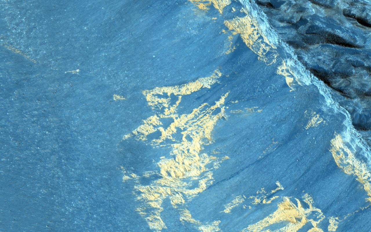
![This enhanced color image from NASA's Mars Reconnaissance Orbiter (MRO) shows what are called "recurring slope lineae"s in Tivat Crater. The narrow, dark flows descend downhill (towards the upper left). Analysis shows that the flows all end at approximately the same slope, which is similar to the angle of repose for sand. RSL are mostly found on steep rocky slopes in dark regions of Mars, such as the southern mid-latitudes, Valles Marineris near the equator, and in Acidalia Planitia on the northern plains. The appearance and growth of these features resemble seeping liquid water, but how they form remains unclear, and this research demonstrated that the RSL flows seen by HiRISE are likely moving granular material like sand and dust. These findings indicate that present-day Mars may not have a significant volume of liquid water. The water-restricted conditions that exist on Mars would make it difficult for Earth-like life to exist near the surface of the planet. The map is projected here at a scale of 25 centimeters (9.8 inches) per pixel. [The original image scale is 25.6 centimeters (10.8 inches) per pixel (with 1 x 1 binning); objects on the order of 77 centimeters (30.3 inches) across are resolved.] North is up. https://photojournal.jpl.nasa.gov/catalog/PIA22114](https://images-assets.nasa.gov/image/PIA22114/PIA22114~medium.jpg)
This enhanced color image from NASA's Mars Reconnaissance Orbiter (MRO) shows what are called "recurring slope lineae"s in Tivat Crater. The narrow, dark flows descend downhill (towards the upper left). Analysis shows that the flows all end at approximately the same slope, which is similar to the angle of repose for sand. RSL are mostly found on steep rocky slopes in dark regions of Mars, such as the southern mid-latitudes, Valles Marineris near the equator, and in Acidalia Planitia on the northern plains. The appearance and growth of these features resemble seeping liquid water, but how they form remains unclear, and this research demonstrated that the RSL flows seen by HiRISE are likely moving granular material like sand and dust. These findings indicate that present-day Mars may not have a significant volume of liquid water. The water-restricted conditions that exist on Mars would make it difficult for Earth-like life to exist near the surface of the planet. The map is projected here at a scale of 25 centimeters (9.8 inches) per pixel. [The original image scale is 25.6 centimeters (10.8 inches) per pixel (with 1 x 1 binning); objects on the order of 77 centimeters (30.3 inches) across are resolved.] North is up. https://photojournal.jpl.nasa.gov/catalog/PIA22114
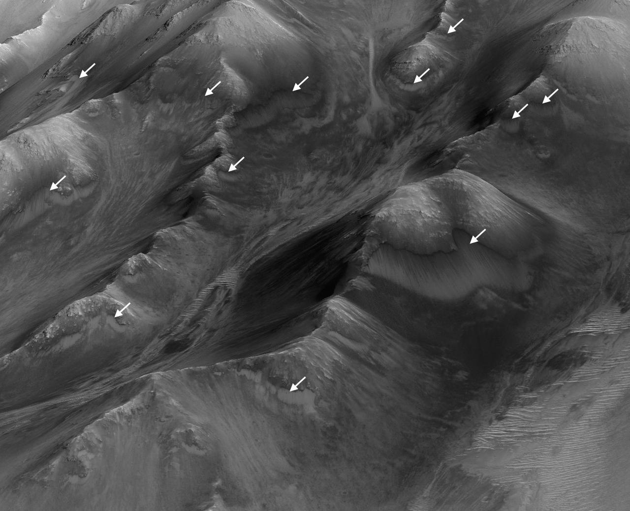
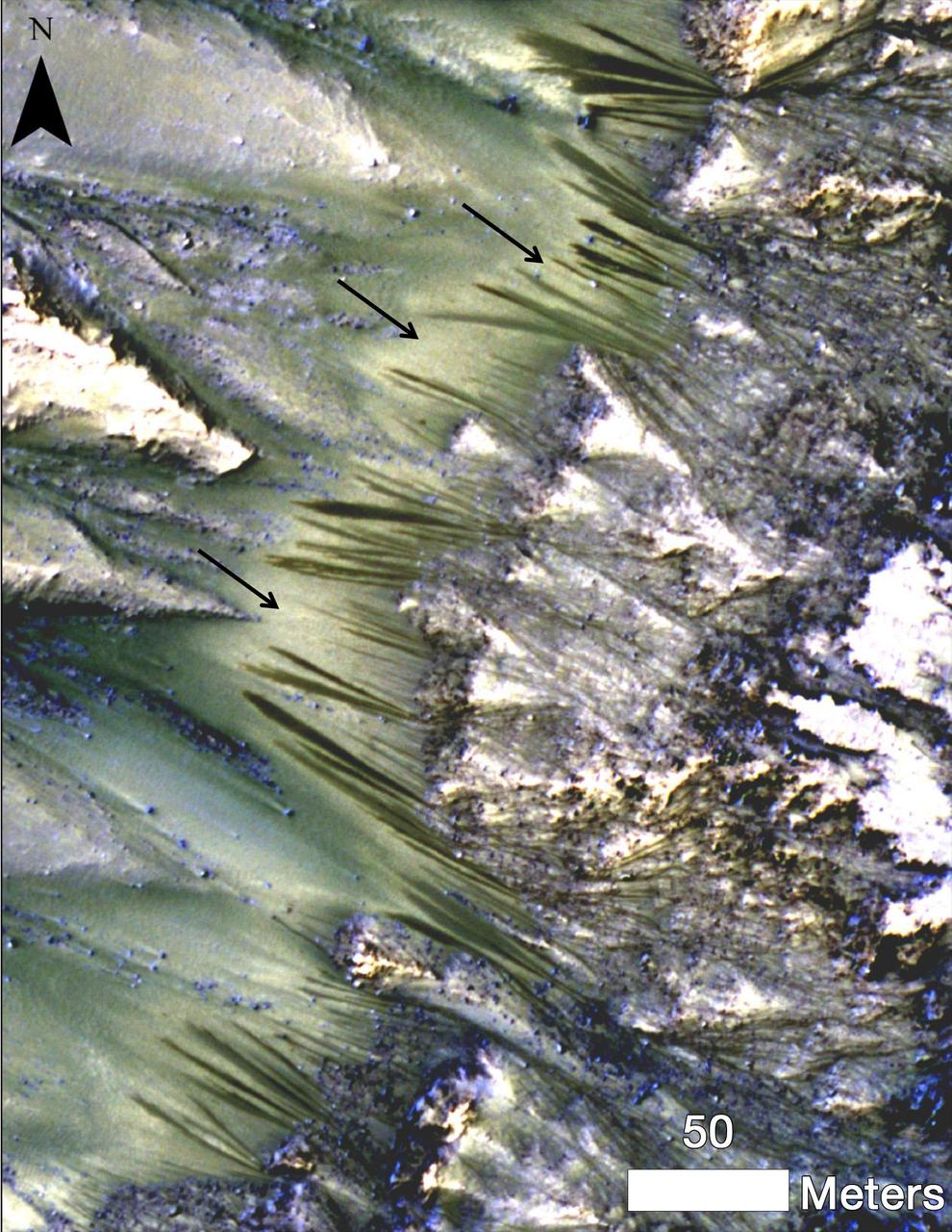
The white arrows indicate locations in this scene where numerous seasonal dark streaks have been identified in the Coprates Montes area of Mars' Valles Marineris by repeated observations from orbit. The streaks, called recurring slope lineae or RSL, extend downslope during a warm season, fade in the colder part of the year, and repeat the process the next Martian year. They are regarded as the strongest evidence for the possibility of liquid water on the surface of modern Mars. This oblique perspective for this view uses a three-dimensional terrain model derived from a stereo pair of observations by the High Resolution Imaging Science Experiment (HiRISE) camera on NASA's Mars Reconnaissance Orbiter. The scene covers an area approximately 1.6 miles (2.5 kilometers) wide. http://photojournal.jpl.nasa.gov/catalog/PIA20757
The extended-mission status of the Mars Reconnaissance Orbiter and the HiRISE camera has greatly increased our understanding of numerous active processes occurring on Mars. By taking carefully planned repeat images of surface, we now have an important record of how the surface evolves for a maximum of 5 Mars years. This image shows the central peak in Porter Crater. Although there are no repeat images here we can infer several active geologic processes, based on morphologic evidence and lessons learned from past well-monitored sites. Shallow gullies are located on the south and east facing slopes of the central peak. These features might have been carved by volatiles, such as carbon dioxide frost, sometime in the recent geologic past. Meanwhile on the northern slopes are several smaller slope features that have a morphology hinting at recurring slope lineae (RSL). Alternatively, these features could be the remnants of past active gullies. Several more HiRISE images would be needed to characterize their behavior and confirm their status as RSL (see "Recurring Slope Lineae in Equatorial Regions of Mars"). Southward on the slopes below the peak is a large dune field. Dunes show sharp crests with prominent ripples, both signs of actively migrating dunes. Also, we can see dust devil tracks crossing the nearby dusty surfaces and clear evidence for ongoing modification by swirling winds that persistently remove surface dust. Ongoing operations by HiRISE are dedicated to studying all of the active surface and atmospheric processes operating on Mars. http://photojournal.jpl.nasa.gov/catalog/PIA19853
The highly incised Martian gullies seen in the top image resemble gullies on Earth that are carved by liquid water. However, when the gullies are observed with the addition of mineralogical information (bottom), no evidence for alteration by water appears. The pictured area spans about 2 miles (3 kilometers) on the eastern rim of Hale Crater. The High Resolution Imaging Science Experiment (HiRISE) camera on NASA's Mars Reconnaissance Orbiter took the visible-light image. Color-coded compositional information added in the lower version comes from the same orbiter's Compact Reconnaissance Imaging Spectrometer for Mars (CRISM). Color coding in light blue corresponds to surface composition of unaltered mafic material, of volcanic origin. Mafic material from the crater rim is carved and transported downslope along the gully channels. No hydrated minerals are observed within the gullies, in the data from CRISM, indicating limited interaction or no interaction of the mafic material with liquid water. These findings and related observations at about 100 other gully sites on Mars suggest that a mechanism not requiring liquid water may be responsible for carving these gullies on Mars. (Gullies on Mars are a different type of feature than seasonal dark streaks called recurring slope lineae or RSL; water in the form of hydrated salt has been identified at RSL sites.) The HiRISE image is a portion of HiRISE observation PSP_002932_1445. The lower image is from the same HiRISE observation, with a CRISM mineral map overlaid. http://photojournal.jpl.nasa.gov/catalog/PIA20763
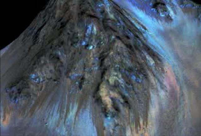
This frame from an animation simulates a fly-around look at one of the places on Mars where dark streaks advance down slopes during warm seasons, possibly involving liquid water. The streaks are roughly the length of a football field. The imaging and topographical information used in this false-color animation come from the High Resolution Imaging Science Experiment (HiRISE) camera on NASA's Mars Reconnaissance Orbiter. These dark features on the slopes are called "recurring slope lineae" or RSL. Planetary scientists using observations with the Compact Reconnaissance Imaging Spectrometer on the same orbiter detected hydrated salts on these slopes at Hale Crater, corroborating the hypothesis that the streaks are formed by briny liquid water. The image was produced by first creating a 3-D computer model (a digital terrain map) of the area based on stereo information from two HiRISE observations, and then draping a false-color image over the land-shape model. The vertical dimension is exaggerated by a factor of 1.5 compared to horizontal dimensions. http://photojournal.jpl.nasa.gov/catalog/PIA19919
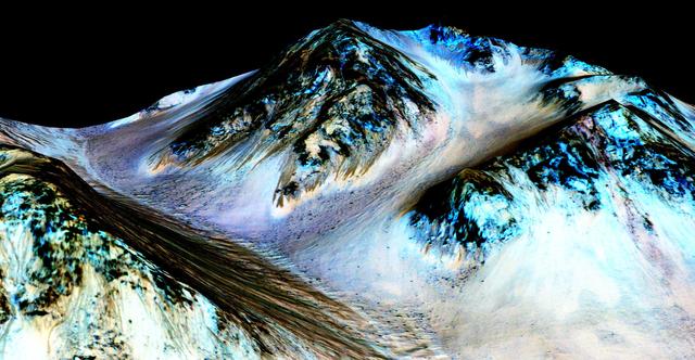
Dark, narrow streaks on Martian slopes such as these at Hale Crater are inferred to be formed by seasonal flow of water on contemporary Mars. The streaks are roughly the length of a football field. The imaging and topographical information in this processed, false-color view come from the High Resolution Imaging Science Experiment (HiRISE) camera on NASA's Mars Reconnaissance Orbiter. These dark features on the slopes are called "recurring slope lineae" or RSL. Planetary scientists using observations with the Compact Reconnaissance Imaging Spectrometer on the same orbiter detected hydrated salts on these slopes at Hale Crater, corroborating the hypothesis that the streaks are formed by briny liquid water. The image was produced by first creating a 3-D computer model (a digital terrain map) of the area based on stereo information from two HiRISE observations, and then draping a false-color image over the land-shape model. The vertical dimension is exaggerated by a factor of 1.5 compared to horizontal dimensions. The camera records brightness in three wavelength bands: infrared, red and blue-green. The draped image is one product from HiRISE observation ESP_03070_1440. http://photojournal.jpl.nasa.gov/catalog/PIA19916