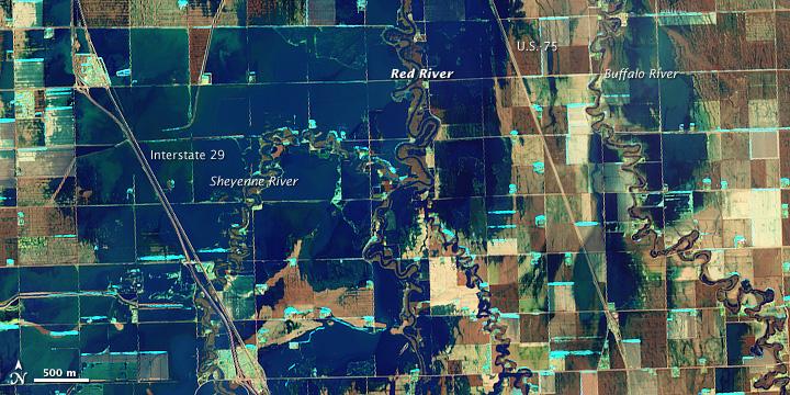
NASA Satellite image acquired March 21, 2010. To see a high res of this image go here: <a href="http://www.flickr.com/photos/gsfc/4455124807/in/photostream/">www.flickr.com/photos/gsfc/4455124807/in/photostream/</a> On March 21, 2010, the Red River crested at 36.99 feet (11.27 meters), according to the National Weather Service. The New York Times reported that the river’s crest was 1 foot (0.3 meters) below predictions and 4 feet (1 meter) below 2009’s record crest. A cold front passing through the area on March 19, 2010, slowed the rate of snowmelt feeding local rivers. That, combined with sandbags and dykes, spared the metropolitan area of Fargo, North Dakota, from serious flooding. North of town, however, agricultural fields and roads flooded. The Advanced Land Imager (ALI) on NASA’s Earth Observing-1 (EO-1) satellite captured these images of fields north of Fargo on March 21, 2010. The top image uses shortwave infrared light, and the bottom image uses visible light. Muddy waters and fallow fields blend together in the true-color image (bottom), but the false-color image (top) distinguishes better between water and land. Blue indicates water and green indicates vegetation. Fallow fields, bare ground, and paved surfaces appear in shades of brown. Cyan suggests pale water and/or sediment. Wide swaths of blue show large areas of standing water. The Sheyenne, Red, and Buffalo Rivers all flow through the area pictured here. According to The New York Times, flooding in rural areas around Fargo resulted primarily from the Red River’s failure to absorb water from the tributaries feeding it. Much of the standing water apparent in this image occurs around the Sheyenne and Buffalo Rivers. Overflowing tributaries left several inches of standing water in agricultural fields and on highways. About 10 miles (16 kilometers) north of Fargo, flooding forced the closure of Interstate 29. NASA image created by Jesse Allen, using EO-1 ALI data provided courtesy of the NASA EO-1 team and the United States Geological Survey. Caption by Michon Scott.. Instrument: EO-1 - ALI. To learn more about this image go here: <a href="http://earthobservatory.nasa.gov/NaturalHazards/view.php?id=43211" rel="nofollow">earthobservatory.nasa.gov/NaturalHazards/view.php?id=43211</a> To learn more about NASA's Goddard Space Flight Center go here: <a href="http://www.nasa.gov/centers/goddard/home/index.html" rel="nofollow">www.nasa.gov/centers/goddard/home/index.html</a>
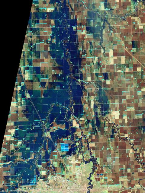
NASA Satellite image acquired March 21, 2010. To see a high res more detail of this image go here: <a href="http://www.flickr.com/photos/gsfc/4455125023/in/photostream/">www.flickr.com/photos/gsfc/4455125023/in/photostream/</a> On March 21, 2010, the Red River crested at 36.99 feet (11.27 meters), according to the National Weather Service. The New York Times reported that the river’s crest was 1 foot (0.3 meters) below predictions and 4 feet (1 meter) below 2009’s record crest. A cold front passing through the area on March 19, 2010, slowed the rate of snowmelt feeding local rivers. That, combined with sandbags and dykes, spared the metropolitan area of Fargo, North Dakota, from serious flooding. North of town, however, agricultural fields and roads flooded. The Advanced Land Imager (ALI) on NASA’s Earth Observing-1 (EO-1) satellite captured these images of fields north of Fargo on March 21, 2010. The top image uses shortwave infrared light, and the bottom image uses visible light. Muddy waters and fallow fields blend together in the true-color image (bottom), but the false-color image (top) distinguishes better between water and land. Blue indicates water and green indicates vegetation. Fallow fields, bare ground, and paved surfaces appear in shades of brown. Cyan suggests pale water and/or sediment. Wide swaths of blue show large areas of standing water. The Sheyenne, Red, and Buffalo Rivers all flow through the area pictured here. According to The New York Times, flooding in rural areas around Fargo resulted primarily from the Red River’s failure to absorb water from the tributaries feeding it. Much of the standing water apparent in this image occurs around the Sheyenne and Buffalo Rivers. Overflowing tributaries left several inches of standing water in agricultural fields and on highways. About 10 miles (16 kilometers) north of Fargo, flooding forced the closure of Interstate 29. NASA image created by Jesse Allen, using EO-1 ALI data provided courtesy of the NASA EO-1 team and the United States Geological Survey. Caption by Michon Scott. Instrument: EO-1 - ALI. To learn more about this image go here: <a href="http://earthobservatory.nasa.gov/NaturalHazards/view.php?id=43211" rel="nofollow">earthobservatory.nasa.gov/NaturalHazards/view.php?id=43211</a> To learn more about NASA's Goddard Space Flight Center go here: <a href="http://www.nasa.gov/centers/goddard/home/index.html" rel="nofollow">www.nasa.gov/centers/goddard/home/index.html</a>
Why does Fargo flood? The Red River of the North, which forms the border between North Dakota and Minnesota, has a long history of severe floods. Major floods include those of 1826, 1897, 1950, 1997, and now 2009.
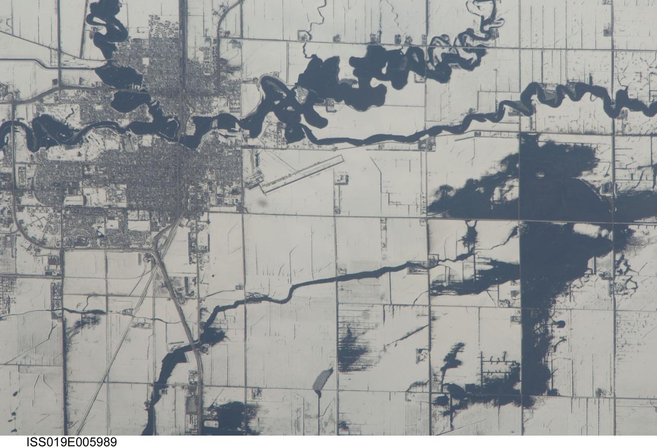
ISS019-E-005989 (9 April 2009) --- Red River floods in North Dakota and Minnesota are featured in this image photographed by an Expedition 19 crewmember on the International Space Station. The Red River, which flows north between North Dakota and Minnesota, flooded for a second time on the day this image was taken (9 April 2009). Two weeks earlier the river had crested at very high levels. The new floodwaters in the Red River, and especially in the less well-drained meandering tributaries east of the river, appear as black shapes against a snowy agricultural landscape defined by rectangular fields. The largest irregular black patches are the flooded low parts of fields along a canalized western tributary of the Red River (right). The city-block patterns of Wahpeton ND and Breckenridge MN, opposite one another on the banks of the Red River, stand out as dark gray patches against the snow at image top left. The main runway of the Henry Stern Airport lies angled northwest directly south of Wahpeton, and its 1.3 kilometers runway length gives scale to the view. Access roads to the agricultural fields tend to follow an orthogonal pattern, while larger roads leading to the cities cut across this pattern (lower left, near Wahpeton). A subtle pattern of drainage ditches and plow lines appear as thin parallel lines throughout fields in the scene.