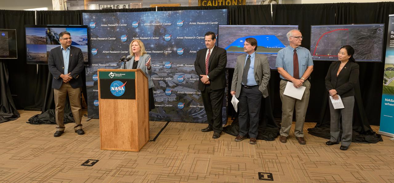
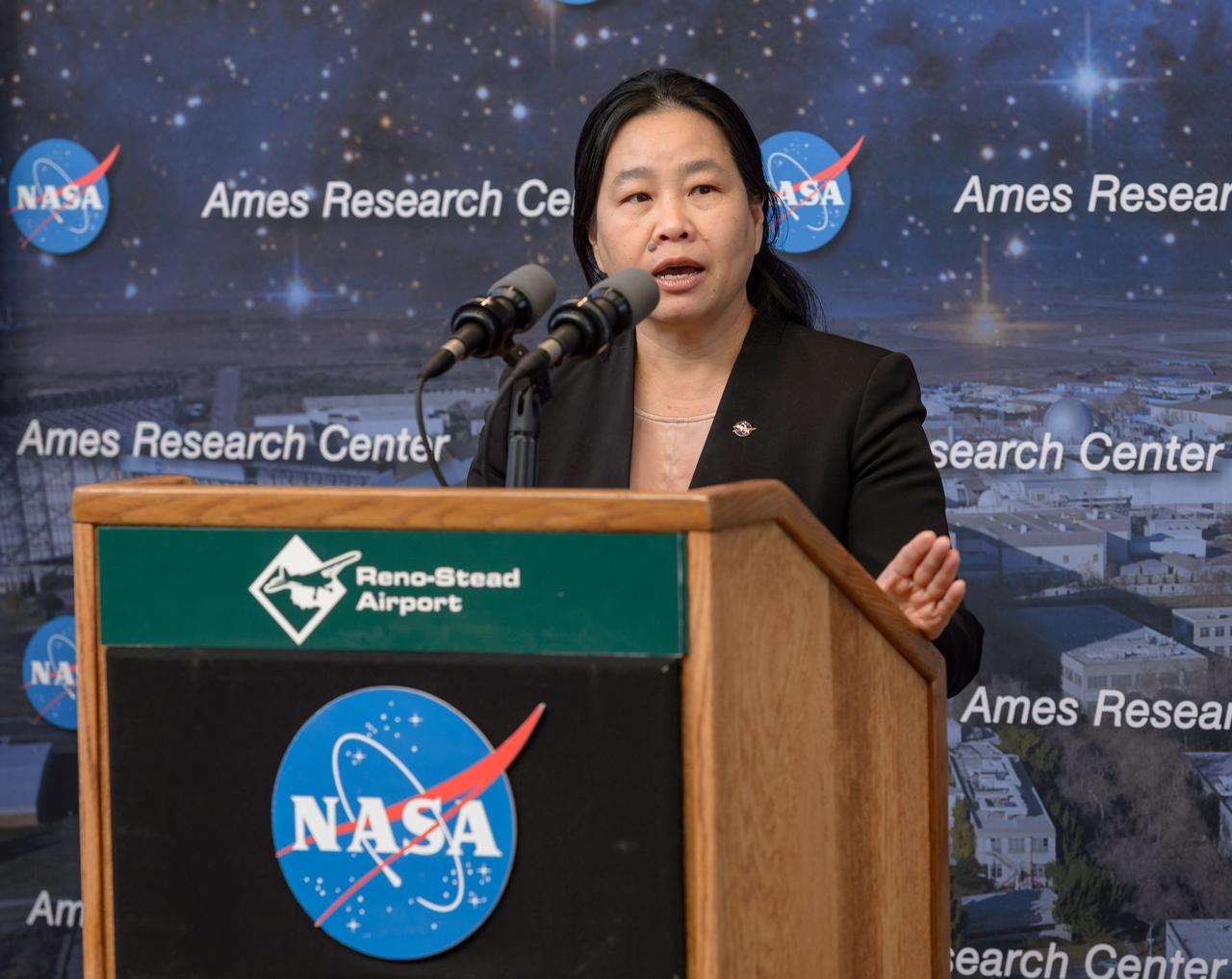
News Conference following the test of Unmanned Aircraft Systems Traffic Management (UTM) technical capability Level 2 (TCL2) at Reno-Stead Airport, Nevada. The UTM Reno Press Conference on Oct. 19, 2016. (Left to Right) Parimal Kopardekar, NASA Ames Senior Engineer for Air Transportation Systems gave an overview of UTM; Maril Mora, President / CEO of the Reno -Tahoe Airport Authority welcomes NASA and Partners; Tom Wilczek, Aerospace and Defence industry representative and Nevada Governor's Office of Economic Development; Mark Baker, Director of Business Development, Nevada Institute of Autonomous Systems; Manos Maragakis, Dean of the College of Engineering, University of Nevada, Reno.
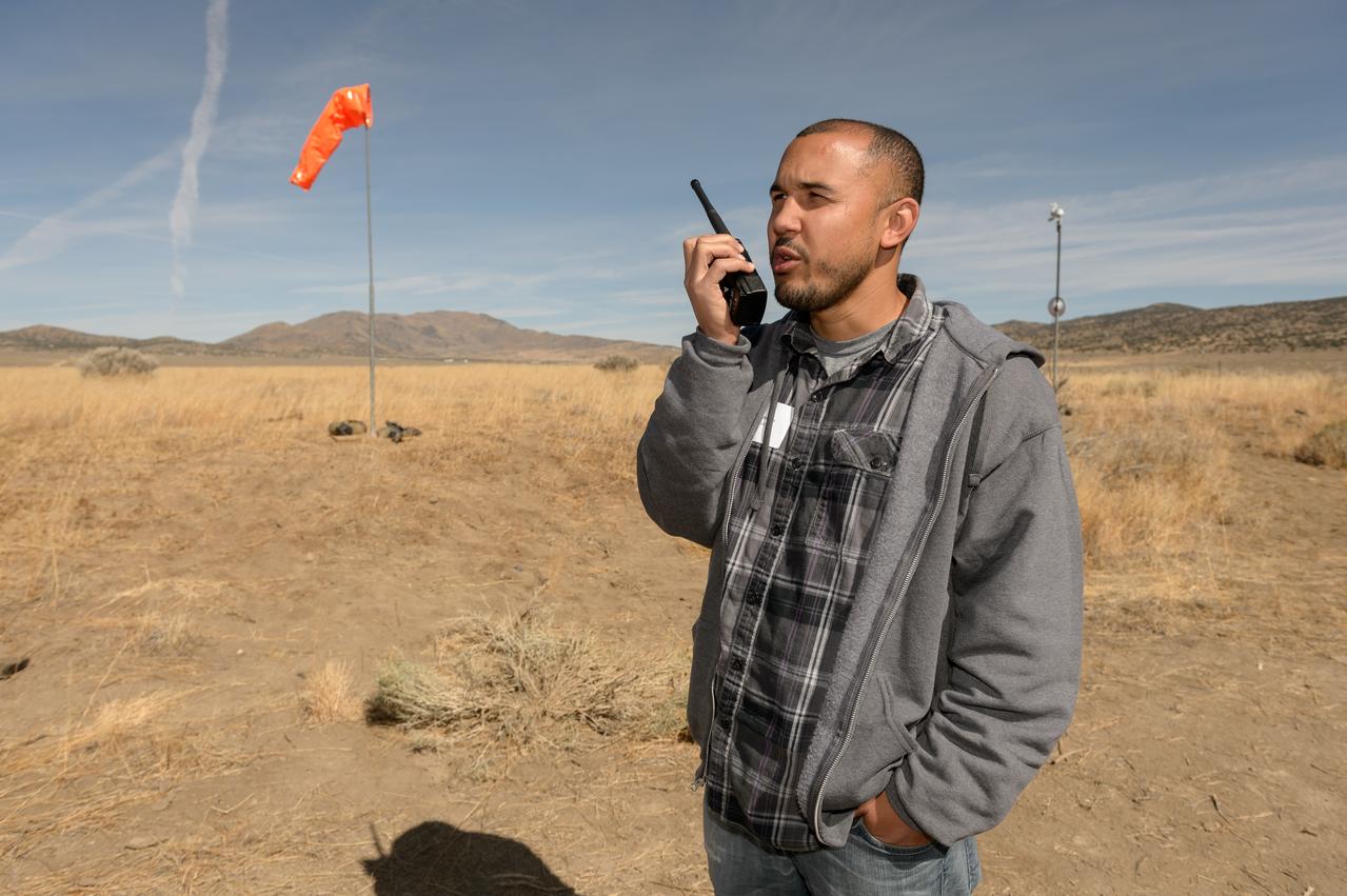
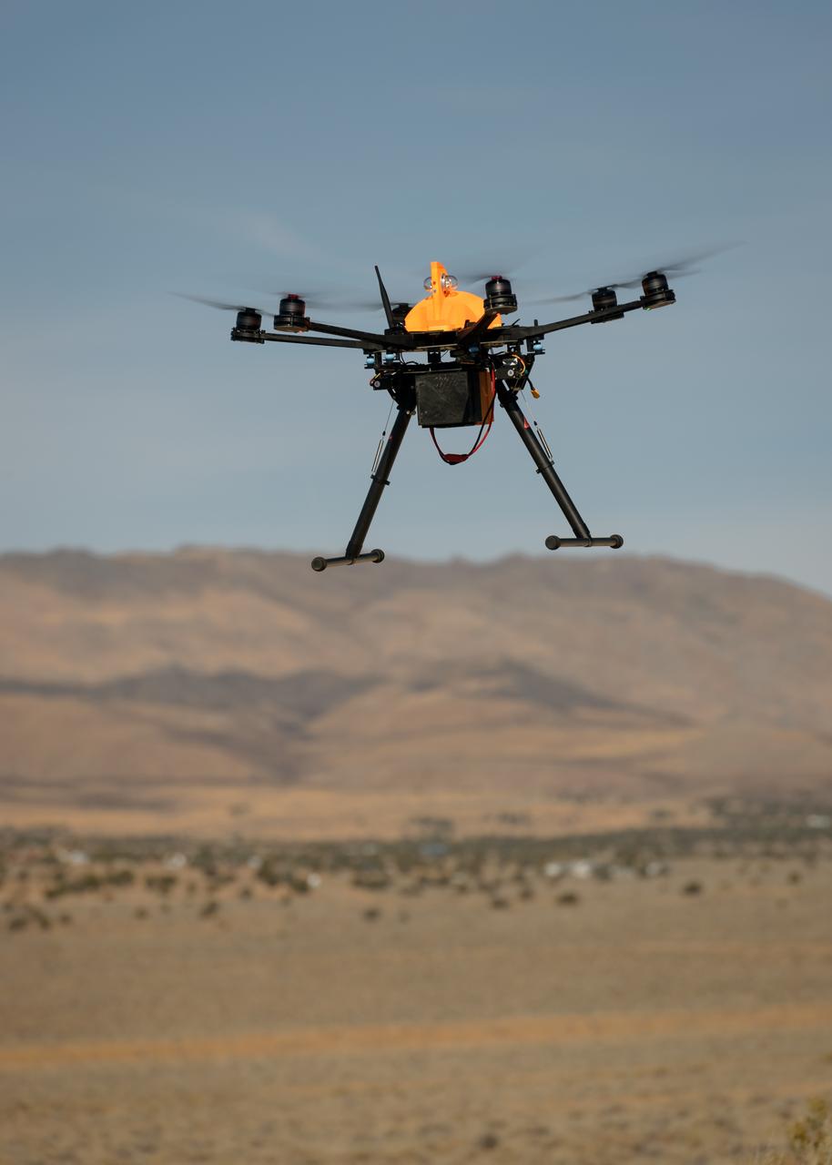
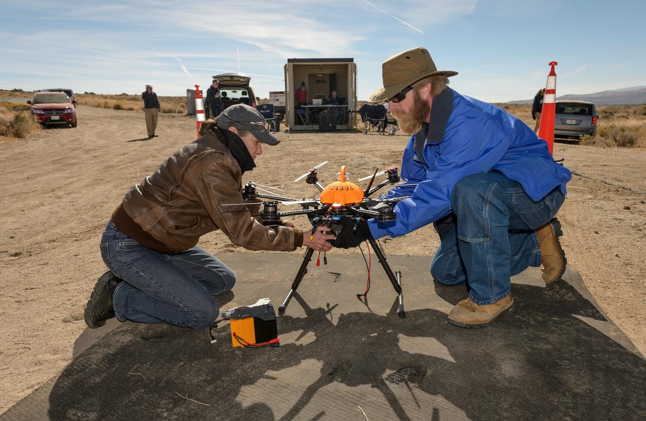
Test of Unmanned Aircraft Systems Traffic Management (UTM) technical capability Level 2 (TCL2) at Reno-Stead Airport, Nevada. During the test, five drones simultaneously crossed paths, separated by altitude. Two drones flew beyond visual line-of-sight and three flew within line-of-sight of their operators.
Test of Unmanned Aircraft Systems Traffic Management (UTM) technical capability Level 2 (TCL2) at Reno-Stead Airport, Nevada. During the test, five drones simultaneously crossed paths, separated by altitude. Two drones flew beyond visual line-of-sight and three flew within line-of-sight of their operators.

Test of Unmanned Aircraft Systems Traffic Management (UTM) technical capability Level 2 (TCL2) at Reno-Stead Airport, Nevada. During the test, five drones simultaneously crossed paths, separated by altitude. Two drones flew beyond visual line-of-sight and three flew within line-of-sight of their operators.
Test of Unmanned Aircraft Systems Traffic Management (UTM) technical capability Level 2 (TCL2) at Reno-Stead Airport, Nevada. During the test, five drones simultaneously crossed paths, separated by altitude. Two drones flew beyond visual line-of-sight and three flew within line-of-sight of their operators.

Test of Unmanned Aircraft Systems Traffic Management (UTM) technical capability Level 2 (TCL2) at Reno-Stead Airport, Nevada. During the test, five drones simultaneously crossed paths, separated by altitude. Two drones flew beyond visual line-of-sight and three flew within line-of-sight of their operators.

Test of Unmanned Aircraft Systems Traffic Management (UTM) technical capability Level 2 (TCL2) at Reno-Stead Airport, Nevada. During the test, five drones simultaneously crossed paths, separated by altitude. Two drones flew beyond visual line-of-sight and three flew within line-of-sight of their operators.
Test of Unmanned Aircraft Systems Traffic Management (UTM) technical capability Level 2 (TCL2) at Reno-Stead Airport, Nevada. During the test, five drones simultaneously crossed paths, separated by altitude. Two drones flew beyond visual line-of-sight and three flew within line-of-sight of their operators.

Test of Unmanned Aircraft Systems Traffic Management (UTM) technical capability Level 2 (TCL2) at Reno-Stead Airport, Nevada. During the test, five drones simultaneously crossed paths, separated by altitude. Two drones flew beyond visual line-of-sight and three flew within line-of-sight of their operators. Precision Hawk pilot readies Lancaster Mark 3 UAS for test flight.

Test of Unmanned Aircraft Systems Traffic Management (UTM) technical capability Level 2 (TCL2) at Reno-Stead Airport, Nevada. During the test, five drones simultaneously crossed paths, separated by altitude. Two drones flew beyond visual line-of-sight and three flew within line-of-sight of their operators. Precision Hawk pilot launches UAS Lancaster Mark 3, one of 11 vehicles in the UTM TCL2 demonstration that will fly beyond line of sight of the pilot in command in Nevada test.

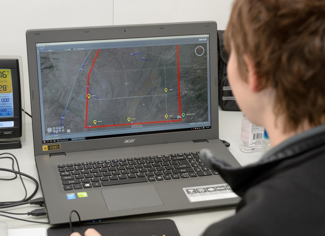
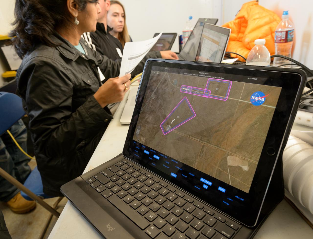
Test of Unmanned Aircraft Systems Traffic Management (UTM) technical capability Level 2 (TCL2) at Reno-Stead Airport, Nevada. During the test, five drones simultaneously crossed paths, separated by altitude. Two drones flew beyond visual line-of-sight and three flew within line-of-sight of their operators. Engineers Priya Venkatesan and Joey Mercer review flight paths using the UAS traffic management research platform at flight operations mission control at NASA’s UTM TCL2 test.

Test of Unmanned Aircraft Systems Traffic Management (UTM) technical capability Level 2 (TCL2) at Reno-Stead Airport, Nevada. During the test, five drones simultaneously crossed paths, separated by altitude. Two drones flew beyond visual line-of-sight and three flew within line-of-sight of their operators. Drone Co-habitation Services operates a Phantom 3 commercial multi-rotor unmanned aircraft, one of 11 vehicles in the UTM TCL2 demonstration that will fly beyond line of sight of the pilot in command in Nevada test.

Test of Unmanned Aircraft Systems Traffic Management (UTM) technical capability Level 2 (TCL2) at Reno-Stead Airport, Nevada. During the test, five drones simultaneously crossed paths, separated by altitude. Two drones flew beyond visual line-of-sight and three flew within line-of-sight of their operators. Engineer Joey Mercer reviews flight paths using the UAS traffic management research platform UTM coordinator app to verify and validate flight paths.
News Conference following the test of Unmanned Aircraft Systems Traffic Management (UTM) technical capability Level 2 (TCL2) at Reno-Stead Airport, Nevada. Mark Baker, Director of Business Development, Nevada Institute of Autonomous Systems.
Test of Unmanned Aircraft Systems Traffic Management (UTM) technical capability Level 2 (TCL2) at Reno-Stead Airport, Nevada. During the test, five drones simultaneously crossed paths, separated by altitude. Two drones flew beyond visual line-of-sight and three flew within line-of-sight of their operators. Karen Bollinger pilot and Nick Atkins of Alaska Center for Unmanned Aircraft Systems Integration program fly Ptarmigan quadcopter, one of 11 vehicles in the UTM TCL2 demonstration that will fly beyond line of sight of the pilot in command in Nevada test.
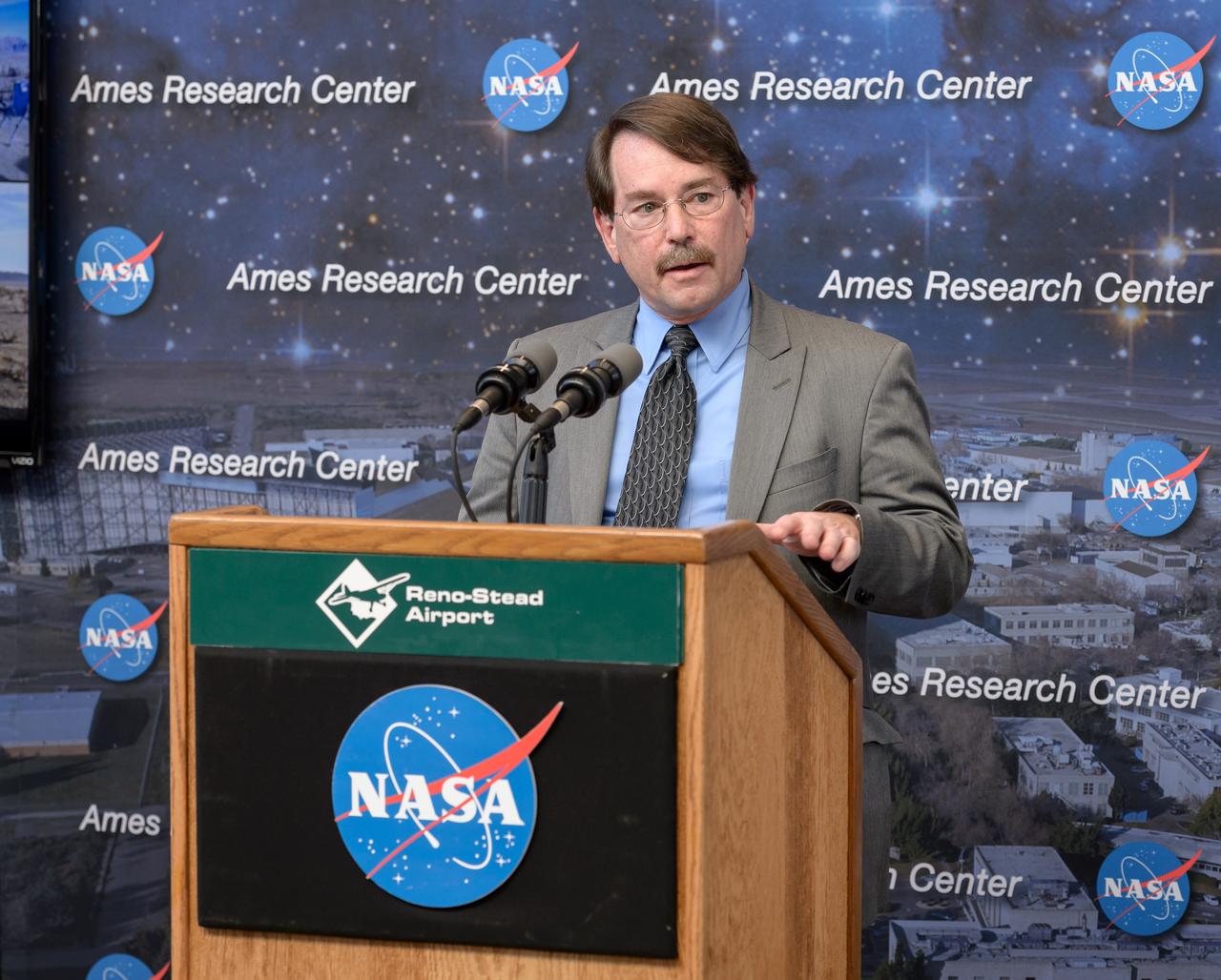
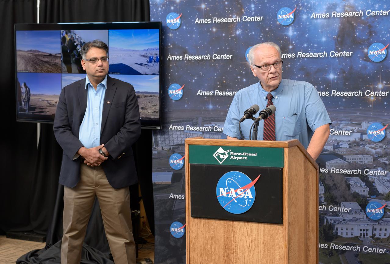
News Conference following the test of Unmanned Aircraft Systems Traffic Management (UTM) technical capability Level 2 (TCL2) at Reno-Stead Airport, Nevada. Huy Tran, NASA Ames Aeronautics Director gives a NASA UTM Project Overview.
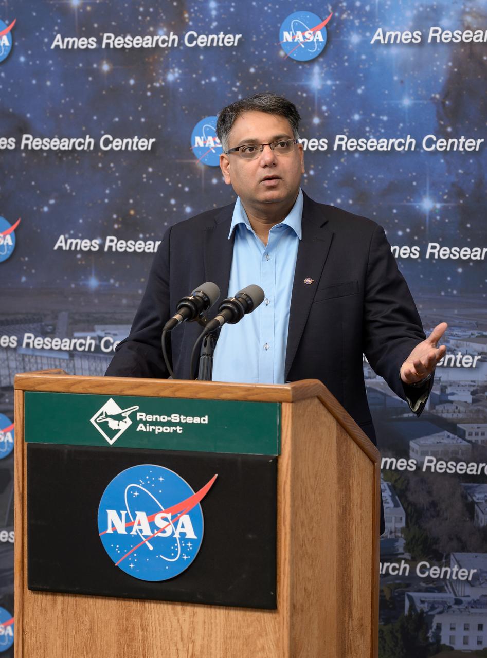
News Conference following the test of Unmanned Aircraft Systems Traffic Management (UTM) technical capability Level 2 (TCL2) at Reno-Stead Airport, Nevada. Parimal Kopardekar, NASA Ames Senior Engineer for Ait Transportation Systems gave an overview of UTM.
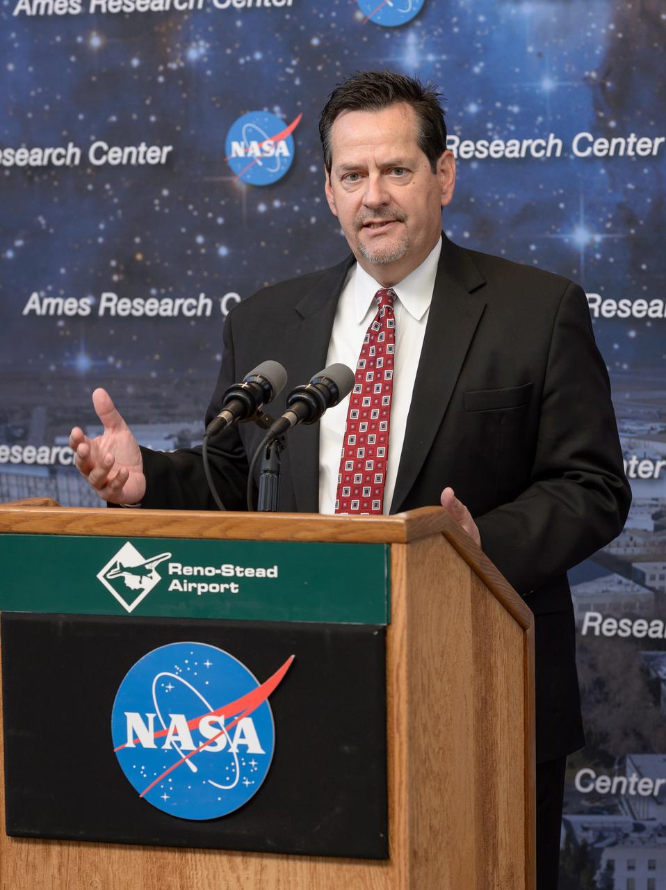
News Conference following the test of Unmanned Aircraft Systems Traffic Management (UTM) technical capability Level 2 (TCL2) at Reno-Stead Airport, Nevada. Tom Wilczek, Aerospace and Defence industry representative and Nevada Govenor's Office of Economic Development.
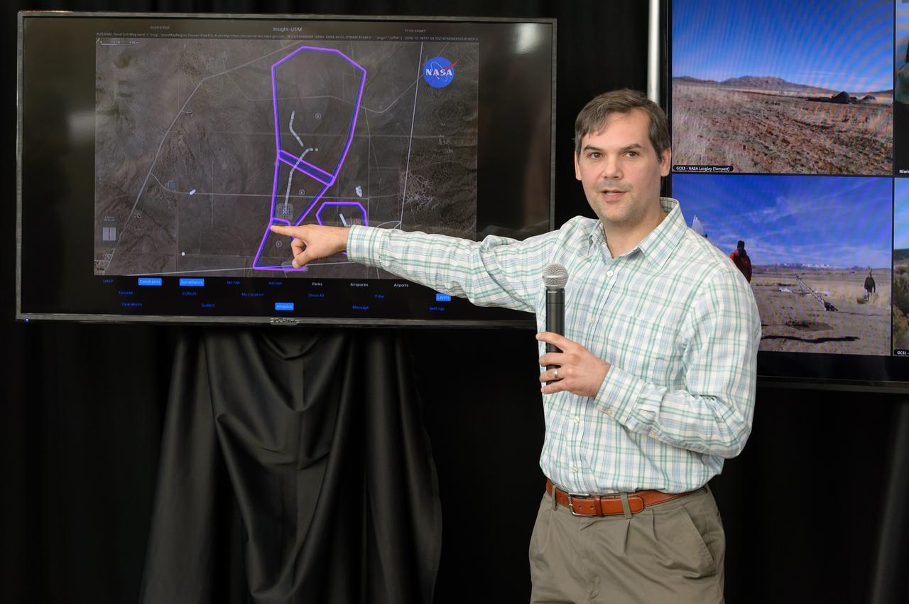
News Conference following the test of Unmanned Aircraft Systems Traffic Management (UTM) technical capability Level 2 (TCL2) at Reno-Stead Airport, Nevada. Joseph Rios, NASA Ames Aerospace Engineer and UTM Technical Lead, describes the purpose of the test and flight scenarios.
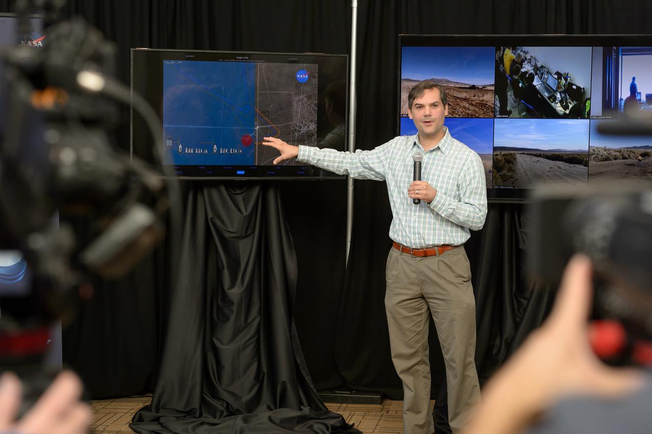
News Conference following the test of Unmanned Aircraft Systems Traffic Management (UTM) technical capability Level 2 (TCL2) at Reno-Stead Airport, Nevada. Joseph Rios, NASA Ames Aerospace Engineer and UTM Technical Lead, describes the purpose of the test and flight scenarios.
News Conference following the test of Unmanned Aircraft Systems Traffic Management (UTM) technical capability Level 2 (TCL2) at Reno-Stead Airport, Nevada. Parimal Kopardekar, NASA Ames Senior Engineer for Ait Transportation Systems gave an overview of UTM (Left).
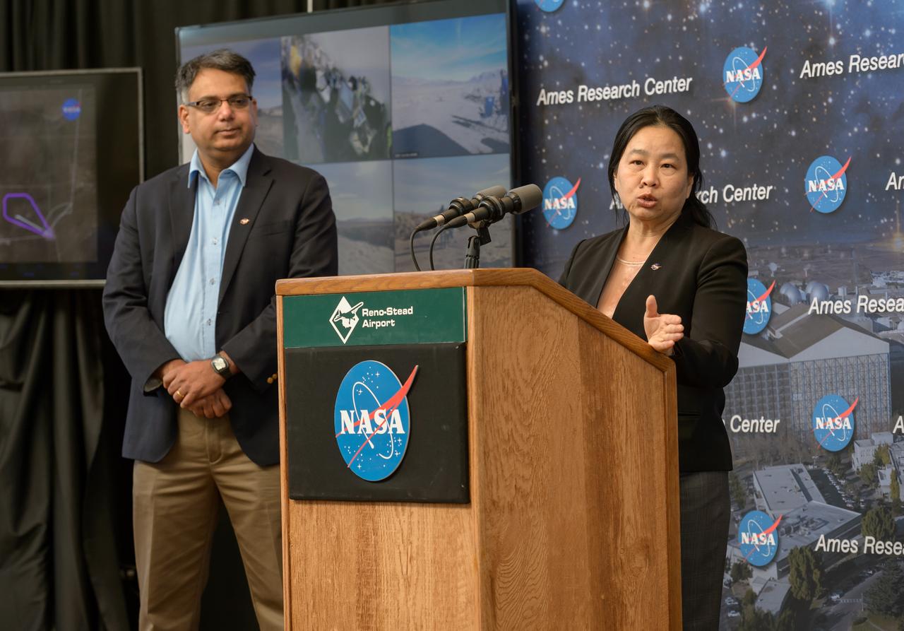
News Conference following the test of Unmanned Aircraft Systems Traffic Management (UTM) technical capability Level 2 (TCL2) at Reno-Stead Airport, Nevada. Parimal Kopardekar, NASA Ames Senior Engineer for Ait Transportation Systems gave an overview of UTM (Left). Huy Tran, NASA Ames Aeronautics Director, presents NASA UTM Project Overview.
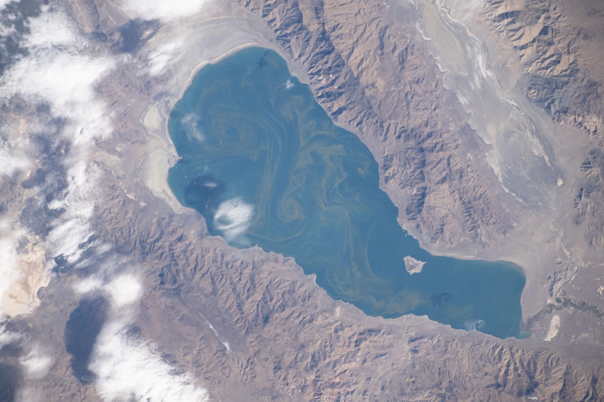
iss073e0919979 (Oct. 19, 2025) --- Pyramid Lake, located northeast of Reno, Nevada, is pictured from the International Space Station as it orbited 265 miles above North America. Surrounded by dramatic desert terrain, the lake is a popular destination for fishing, camping, and birdwatching.
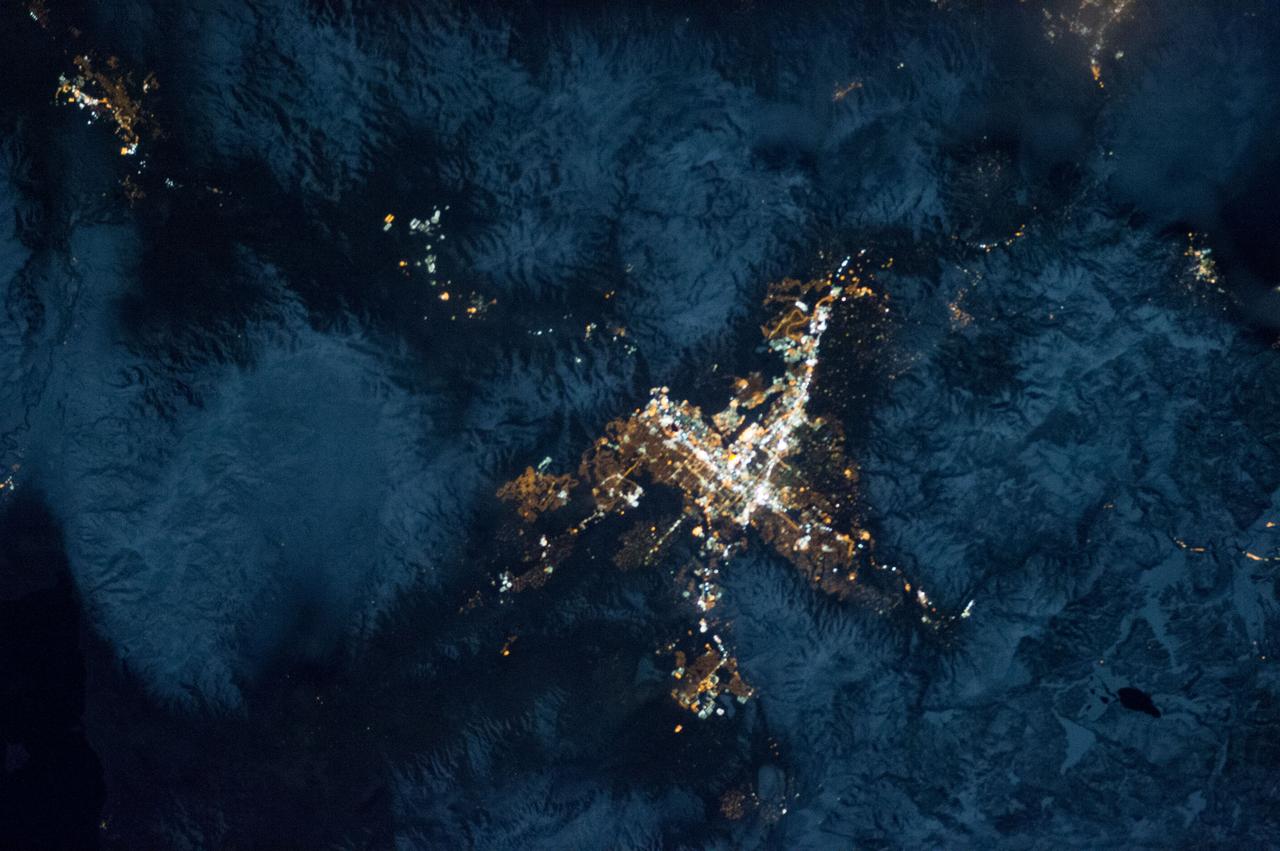
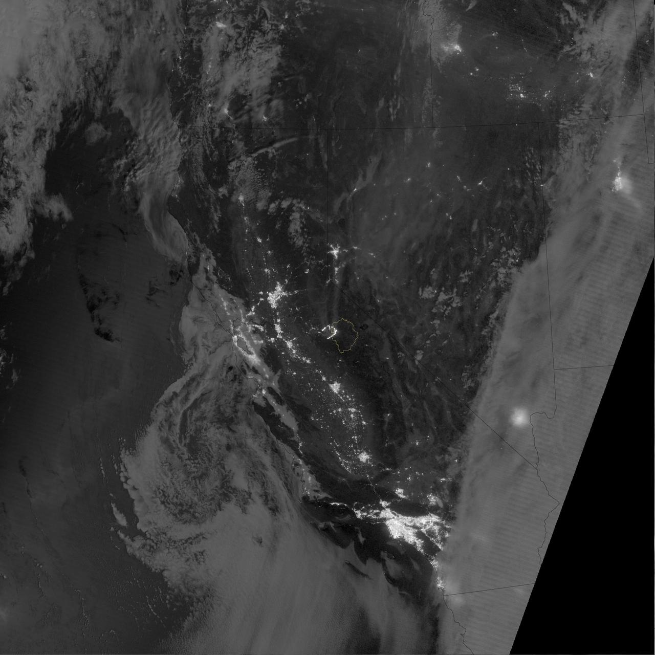
ISS034-E-035548 (28 Jan. 2013) --- A nighttime view of the Reno, Nevada metropolitan area is featured in this image photographed by an Expedition 34 crew member on the International Space Station. Known as ?the biggest little city in the world?, the city of Reno is located in Truckee Meadows along the eastern foothills of the Sierra Nevada near the California border. It forms part of the Reno-Sparks metropolitan area?the largest such area in northern Nevada, and the second largest in the state after Las Vegas. Lake Tahoe, a major destination for skiing and other outdoor recreational activities, is located less than 50 kilometers to the southwest of the Reno-Sparks metro area. The relatively isolated nature of the metropolitan area within the surrounding terrain is highlighted in this nighttime image. The major industrial and commercial areas of both Reno and Sparks are brightly lit at center. The major street grid is visible as orange linear features adjacent to the industrial/commercial areas. Residential areas appear dark in contrast. The Reno-Tahoe International Airport (center) is visible as a dark, dagger-shaped region in the southeast quarter of the metropolitan area. At the time this photograph was taken, the moon was in a waning gibbous phase (98 percent of a full moon). Moonlight provided enough illumination of the ground surface such that the topography, accentuated by snow cover, surrounding the Reno-Sparks area is clearly visible (upper right, lower right) following color enhancement.
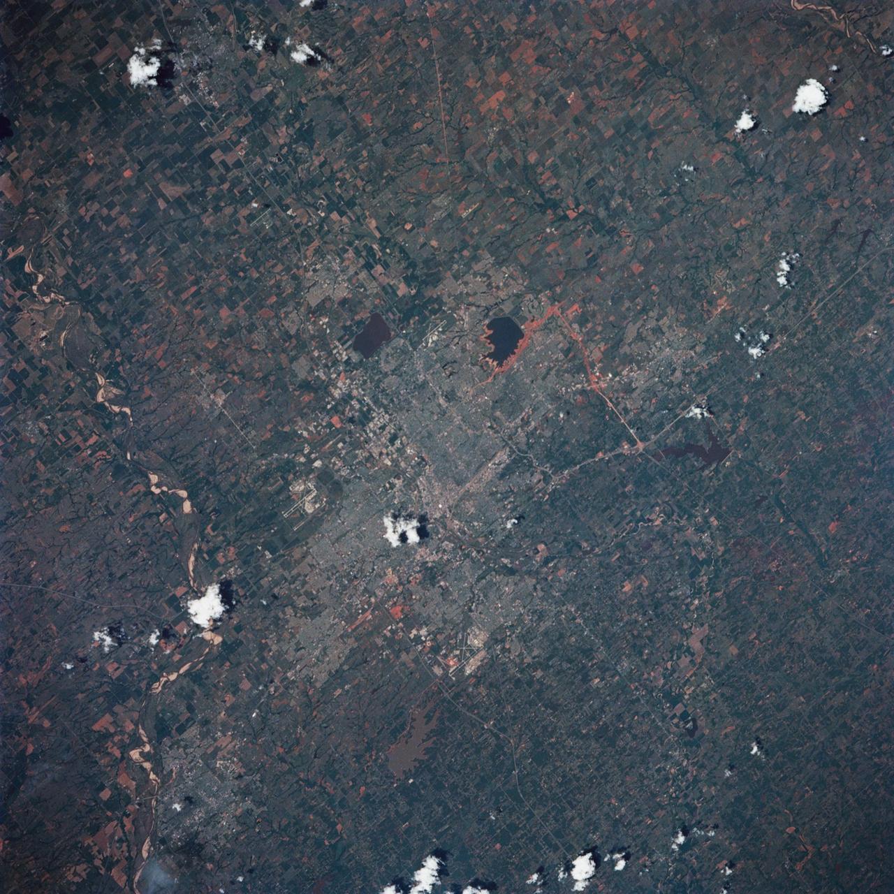
STS039-85-029 (28 April-6 May 1991) --- This 70mm frame is one of the best pictures of the Oklahoma City area from the manned space program, according to NASA photo experts studying STS-39 onboard photography. The central business district is near the center. Several municipalities are visible, along with thousands of acres of farmland. The towns of Norman and Moore and the South Canadian River are in the bottom (south). El Reno and Wiley Post Field off I-40W are just below center in lower left quadrant. Edmond is seen at the top (north). Tinker Field can be seen north of I-40E at right center. Lake Overholser shows recent spring rainfall northwest of the central business district.
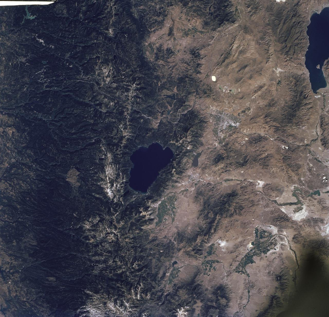
STS085-716-061 (7 - 19 August 1997) --- The dark green forests of the Sierra Nevada Mts. occupy the left side of the picture. Reno lies between Lake Tahoe (center) and Pyramid Lake (top right). Lake Tahoe, is a clear, deep alpine lake (over 505 meters deep), surrounded by Montane forest, ski resorts and casinos. Although Tahoe is known as one of the clearest lakes in the world, water quality in the lake has been declining due to soil erosion from development. Since 1968, it has lost about 30 feet of clarity. A partnership was recently formed between environmentalists and resort owners to protect their common interest in keeping the lake as clear as possible. Over the last five years they have slowed the erosion and the growth of algae that it causes so that clarity is now "only" lost at a rate of roughly one foot per year. Pyramid Lake (on the upper right of the photo) is as different from Tahoe as a lake could be. The sagebrush desert around the lake and is owned by the Pyramid Lake Paiute tribe who manage it as a fishery for an endangered sucker (fish), the cui-cui. The tribe has added modern fisheries' biology methods to their traditional management and chooses not to develop the lake as a recreation destination. Anaho Island, in the lower half of the lake, is a wildlife refuge managed for American White Pelicans which fly hundreds of miles each day to get from this safe breeding area to the shallow marshes where they feed. Directly above Lake Tahoe is Donner pass, near the site where the beleaguered Donner Party spent the winter of 1846 - 1847 trapped in the mountains. Several shallow ephemeral lakes can be seen in Lemmon Valley north of Reno's core urban area. These lakes would normally have dried up by August when this photo was taken, but are still wet because of the extremely wet winter and floods of January 1997.

Norwegian explorer Roald Amundsen became the first man to reach the South Pole in December 1911. More than 100 years later, an international team of scientists that includes a NASA researcher has proven that air pollution from industrial activities arrived to the planet’s southern pole long before any human. Using data from 16 ice cores collected from widely spaced locations around the Antarctic continent, including the South Pole, a group led by Joe McConnell of the Desert Research Institute (DRI) in Reno, Nevada, created the most accurate and precise reconstruction to date of lead pollution over Earth’s southernmost continent. The new record, described in an article published today in the online edition of the Nature Publishing Group’s journal Scientific Reports, spans a 410-year period from 1600 to 2010. More here: <a href="http://1.usa.gov/1oB4p9U" rel="nofollow">1.usa.gov/1oB4p9U</a> <b><a href="http://www.nasa.gov/audience/formedia/features/MP_Photo_Guidelines.html" rel="nofollow">NASA image use policy.</a></b> <b><a href="http://www.nasa.gov/centers/goddard/home/index.html" rel="nofollow">NASA Goddard Space Flight Center</a></b> enables NASA’s mission through four scientific endeavors: Earth Science, Heliophysics, Solar System Exploration, and Astrophysics. Goddard plays a leading role in NASA’s accomplishments by contributing compelling scientific knowledge to advance the Agency’s mission. <b>Follow us on <a href="http://twitter.com/NASAGoddardPix" rel="nofollow">Twitter</a></b> <b>Like us on <a href="http://www.facebook.com/pages/Greenbelt-MD/NASA-Goddard/395013845897?ref=tsd" rel="nofollow">Facebook</a></b> <b>Find us on <a href="http://instagrid.me/nasagoddard/?vm=grid" rel="nofollow">Instagram</a></b>

NASA’s Aqua satellite captured a large area of smoke from the Long Valley Wildfire that was affecting Yosemite National Park. This natural-color satellite image was collected by the Moderate Resolution Imaging Spectroradiometer instrument that flies aboard the Aqua satellite. The image, taken July 20, showed actively burning areas in red, as detected by MODIS’s thermal bands. According to Inciweb, an interagency all-risk incident information management system that coordinates with federal, state and local agencies to manage wildfires, the fire started on Tuesday July 11, 2017. It is located about two miles north of Doyle, California and about 50 miles north of Reno, Nevada. As of July 21 the fire covered 83,733 acres and was 91 percent contained. NASA image courtesy NASA MODIS Rapid Response Team <b><a href="http://www.nasa.gov/audience/formedia/features/MP_Photo_Guidelines.html" rel="nofollow">NASA image use policy.</a></b> <b><a href="http://www.nasa.gov/centers/goddard/home/index.html" rel="nofollow">NASA Goddard Space Flight Center</a></b> enables NASA’s mission through four scientific endeavors: Earth Science, Heliophysics, Solar System Exploration, and Astrophysics. Goddard plays a leading role in NASA’s accomplishments by contributing compelling scientific knowledge to advance the Agency’s mission. <b>Follow us on <a href="http://twitter.com/NASAGoddardPix" rel="nofollow">Twitter</a></b> <b>Like us on <a href="http://www.facebook.com/pages/Greenbelt-MD/NASA-Goddard/395013845897?ref=tsd" rel="nofollow">Facebook</a></b> <b>Find us on <a href="http://instagrid.me/nasagoddard/?vm=grid" rel="nofollow">Instagram</a></b>
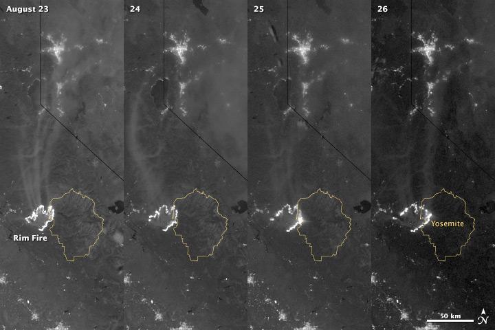
The winter of 2013 was among the driest on record for California, setting the stage for an active fire season. By August 26, the Rim Fire had made its way into the record books. At just 15 percent contained, the fire is now the 13th largest in California since records began in 1932. Apart from being large, the fire is also threatening one of the United States’ greatest natural treasures: Yosemite National Park. The Visible Infrared Imaging Radiometer Suite (VIIRS) on the Suomi NPP satellite tracked the growth of the fire between August 23 and August 26 in this series of nighttime images. The VIIRS day-night band is extremely sensitive to low light, making it possible to see the fire front from space. The brightest, most intense parts of the fire glow white, exceeding the brightness of the lights of Reno, Nevada to the north. Pale gray smoke streams north away from the fire throughout the sequence. The perimeter of the fire grows from day to day along different fronts, depending on winds and fire fighting efforts. On August 24, fire fighters focused their efforts on containing the western edge of the fire to prevent it from burning into Tuolumne City and the populated Highway 108 corridor. They also fought the eastern edge of the fire to protect Yosemite National Park. These efforts are evident in the image: Between August 23 and 24, the eastern edge of the fire held steady, and the western edge receded. The fire grew in the southeast. On the morning of August 25 fire managers reported that the fire was growing in the north and east. In the image, the most intense activity is just inside Yosemite National Park. Fire fighters reported that the Rim Fire continued to be extremely active on its eastern front on the morning of August 26, and this activity is visible in the image. By 8:00 a.m., the fire had burned 149,780 acres. The fire forced firefighters in Yosemite National Park to take measures to protect the Merced and Tuolumne Groves of Giant Sequoias, but the National Park Service reported that the trees were not in imminent danger. While parts of the park are closed, webcams show that most of the park has not been impacted. The Rim Fire started on the afternoon of August 17. It has destroyed 23 structures and threatened 4,500 other buildings. Its cause is under investigation. More details: <a href="http://1.usa.gov/18ilEAA" rel="nofollow">1.usa.gov/18ilEAA</a> NASA Earth Observatory image by Jesse Allen and Robert Simmon, using VIIRS Day Night Band data. Caption by Holli Riebeek. Instrument: Suomi NPP - VIIRS <b><a href="http://www.nasa.gov/audience/formedia/features/MP_Photo_Guidelines.html" rel="nofollow">NASA image use policy.</a></b> <b><a href="http://www.nasa.gov/centers/goddard/home/index.html" rel="nofollow">NASA Goddard Space Flight Center</a></b> enables NASA’s mission through four scientific endeavors: Earth Science, Heliophysics, Solar System Exploration, and Astrophysics. Goddard plays a leading role in NASA’s accomplishments by contributing compelling scientific knowledge to advance the Agency’s mission. <b>Follow us on <a href="http://twitter.com/NASA_GoddardPix" rel="nofollow">Twitter</a></b> <b>Like us on <a href="http://www.facebook.com/pages/Greenbelt-MD/NASA-Goddard/395013845897?ref=tsd" rel="nofollow">Facebook</a></b> <b>Find us on <a href="http://instagram.com/nasagoddard?vm=grid" rel="nofollow">Instagram</a></b>
The winter of 2013 was among the driest on record for California, setting the stage for an active fire season. By August 26, the Rim Fire had made its way into the record books. At just 15 percent contained, the fire is now the 13th largest in California since records began in 1932. Apart from being large, the fire is also threatening one of the United States’ greatest natural treasures: Yosemite National Park. The Visible Infrared Imaging Radiometer Suite (VIIRS) on the Suomi NPP satellite tracked the growth of the fire between August 23 and August 26 in a series of nighttime images. The VIIRS day-night band is extremely sensitive to low light, making it possible to see the fire front from space. The brightest, most intense parts of the fire glow white, exceeding the brightness of the lights of Reno, Nevada to the north. Pale gray smoke streams north away from the fire throughout the sequence. The perimeter of the fire grows from day to day along different fronts, depending on winds and fire fighting efforts. On August 24, fire fighters focused their efforts on containing the western edge of the fire to prevent it from burning into Tuolumne City and the populated Highway 108 corridor. They also fought the eastern edge of the fire to protect Yosemite National Park. These efforts are evident in the image: Between August 23 and 24, the eastern edge of the fire held steady, and the western edge receded. The fire grew in the southeast. On the morning of August 25 fire managers reported that the fire was growing in the north and east. In the image, the most intense activity is just inside Yosemite National Park. Fire fighters reported that the Rim Fire continued to be extremely active on its eastern front on the morning of August 26, and this activity is visible in the image. By 8:00 a.m., the fire had burned 149,780 acres. The fire forced firefighters in Yosemite National Park to take measures to protect the Merced and Tuolumne Groves of Giant Sequoias, but the National Park Service reported that the trees were not in imminent danger. While parts of the park are closed, webcams show that most of the park has not been impacted. The Rim Fire started on the afternoon of August 17. It has destroyed 23 structures and threatened 4,500 other buildings. Its cause is under investigation. More details: <a href="http://1.usa.gov/18ilEAA" rel="nofollow">1.usa.gov/18ilEAA</a> NASA Earth Observatory image by Jesse Allen and Robert Simmon, using VIIRS Day Night Band data. Caption by Holli Riebeek. Instrument: Suomi NPP - VIIRS <b><a href="http://www.nasa.gov/audience/formedia/features/MP_Photo_Guidelines.html" rel="nofollow">NASA image use policy.</a></b> <b><a href="http://www.nasa.gov/centers/goddard/home/index.html" rel="nofollow">NASA Goddard Space Flight Center</a></b> enables NASA’s mission through four scientific endeavors: Earth Science, Heliophysics, Solar System Exploration, and Astrophysics. Goddard plays a leading role in NASA’s accomplishments by contributing compelling scientific knowledge to advance the Agency’s mission. <b>Follow us on <a href="http://twitter.com/NASA_GoddardPix" rel="nofollow">Twitter</a></b> <b>Like us on <a href="http://www.facebook.com/pages/Greenbelt-MD/NASA-Goddard/395013845897?ref=tsd" rel="nofollow">Facebook</a></b> <b>Find us on <a href="http://instagram.com/nasagoddard?vm=grid" rel="nofollow">Instagram</a></b>