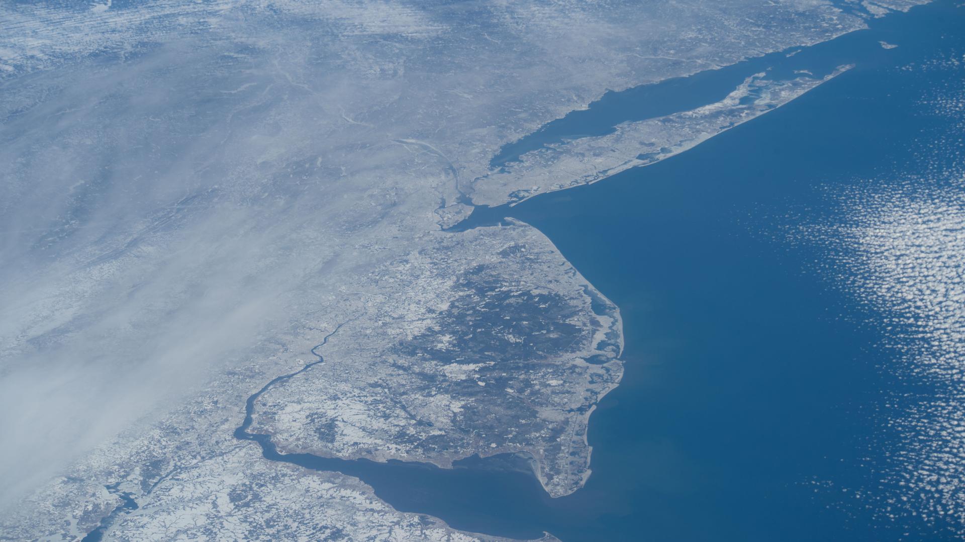
iss074e0209280 (Jan. 28, 2026) --- The wintry landscape from Delaware to Rhode Island is seen from the International Space Station as it orbited 259 miles above the Atlantic coast of the United States. Temperatures in New York City ranged from a low of about 14 degrees Fahrenheit to a high of around 23 degrees when this photograph was taken.

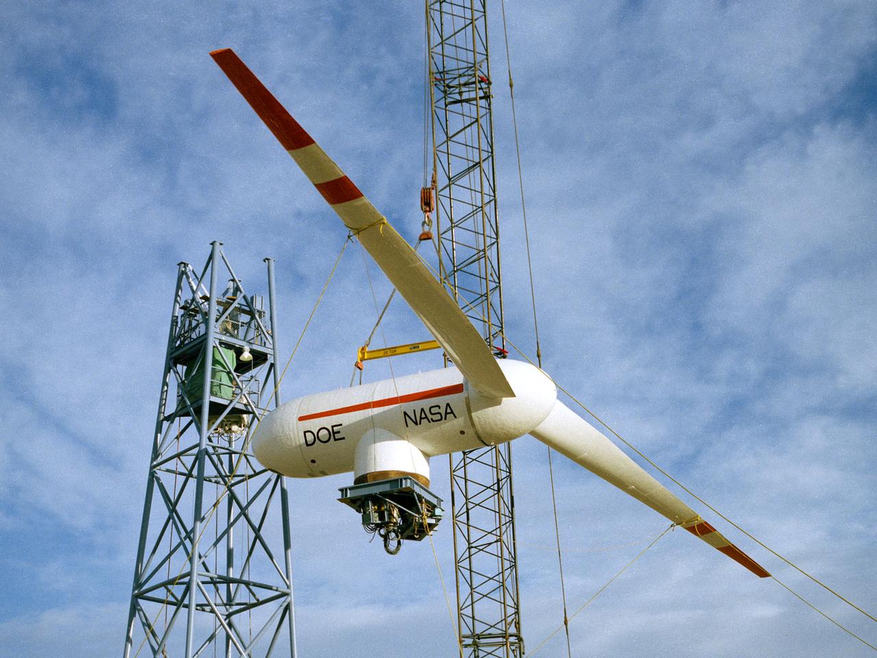
A Mod-0A 200-kilowatt wind turbine designed by National Aeronautics and Space Administration (NASA) Lewis Research Center and constructed in Block Island, Rhode Island. The wind turbine program was a joint program between NASA and the Energy Research and Development Administration (ERDA) during the 1970s to develop less expensive forms of energy. NASA Lewis was assigned the responsibility of developing large horizontal-axis wind turbines. The program included a series of increasingly powerful wind turbines, designated: Mod-0A, Mod-1, WTS-4, and Mod-5. The program’s first device was a Mod-0 100-kilowatt wind turbine test bed at NASA’s Plum Brook Station. This Mod-0A 200-kilowatt turbine, completed in 1977, was the program’s second-generation device. It included a 125-foot diameter blade atop a 100-foot tall tower. This early wind turbine was designed determine its operating problems, integrate with the local utilities, and assess the attitude of the local community. There were additional Mod-0A turbines built in Culebra, Puerto Rico; Clayton, New Mexico; and Oahu, Hawaii. The Mod-0A turbines suffered durability issues with the rotor blade and initially appeared unreliable. NASA engineers addressed the problems, and the turbines proved to be reliable and efficient devices that operated for a number of years. The information gained from these early models was vital to the design and improvement of the later generations.
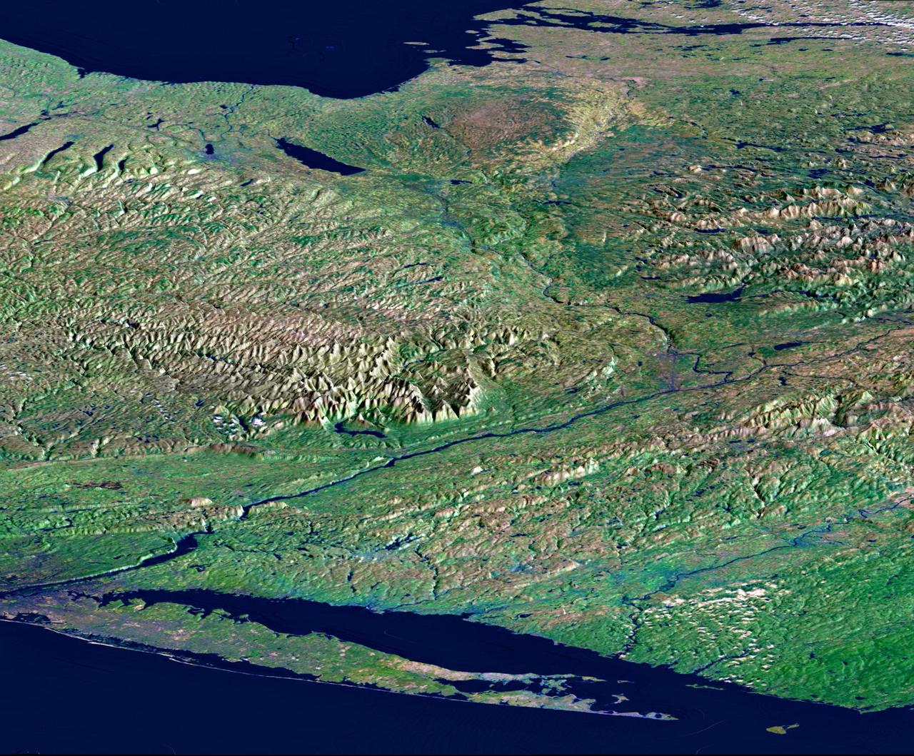
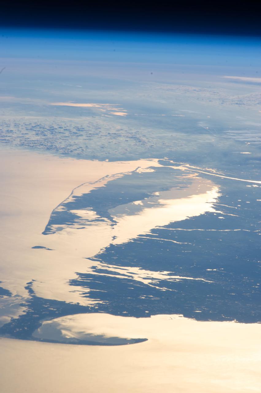
From Lake Ontario and the St. Lawrence River and extending to Long Island, this perspective view shows the varied topography of eastern New York State and parts of Massachusetts, Connecticut, Pennsylvania, New Jersey and Rhode Island.
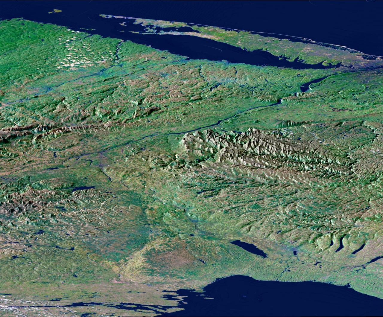
From Lake Ontario and the St. Lawrence River and extending to Long Island, this perspective view shows the varied topography of eastern New York State and parts of Massachusetts, Connecticut, Pennsylvania, New Jersey and Rhode Island.
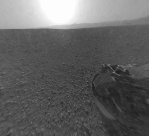
This is a version of one of the first images taken by a rear Hazard-Avoidance camera on NASA Curiosity rover and shows part of the rim of Gale Crater, which is a feature the size of Connecticut and Rhode Island combined.

This is a version of one of the first images taken by a rear Hazard-Avoidance camera on NASA Curiosity rover and shows part of the rim of Gale Crater, which is a feature the size of Connecticut and Rhode Island combined.
NASA QuikScat satellite instrument kept an eye on an iceberg the size of Rhode Island, the first time this space technology had been used to track a potential threat to international shipping.
SL2-103-967 (22 June 1973) --- This view of lower New England, (41.5N, 72.0W) shows a rare cloud-free area stretching from northern Long Island across the states of Connecticut, Rhode Island and Massachusetts. The total area covered by this photo is more than 25,000 square miles and includes all of Rhode Island, most of Massachusetts and Connecticut, part of New York and the coastal waters of the Atlantic Ocean. Cape Cod, Boston and the offshore islands are distinctive features. Photo credit: NASA
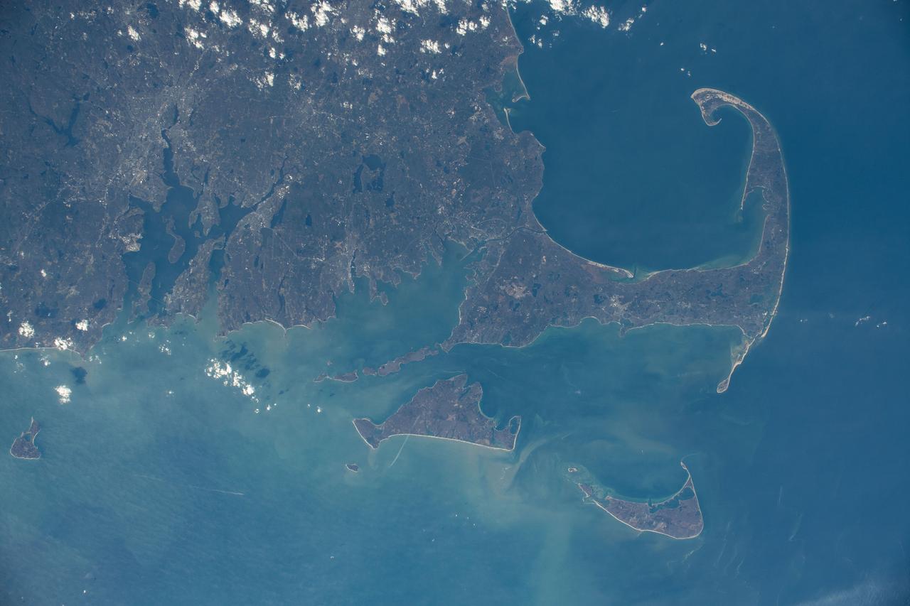
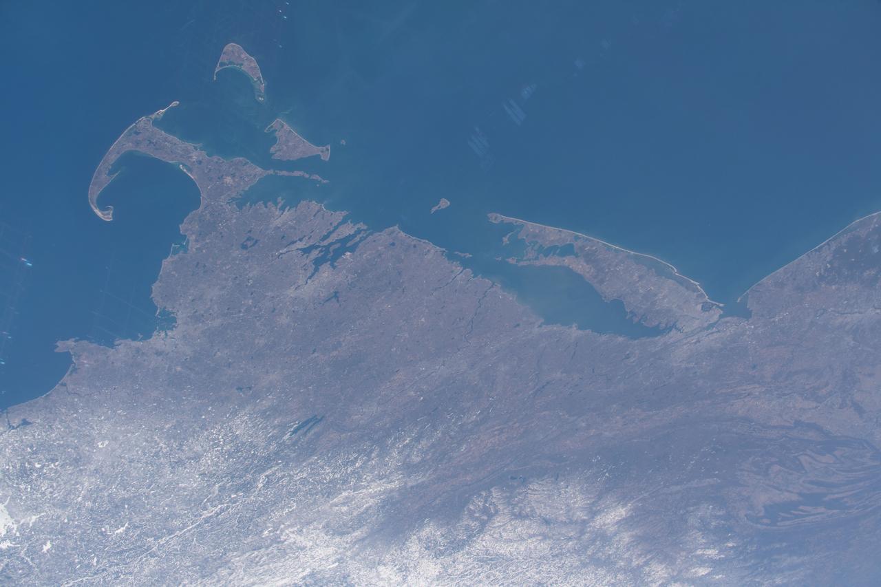
iss070e039484 (Dec. 13, 2023) --- Rhode Island and Massachusetts, including Cape Cod Bay and the islands of Martha's Vineyard and Nantucket, are pictured from the International Space Station as it orbited 261 miles above the notheastern United States.

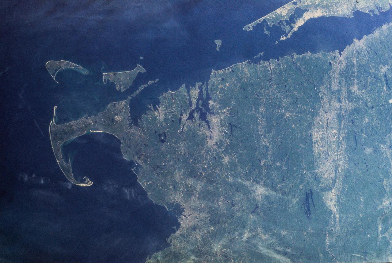
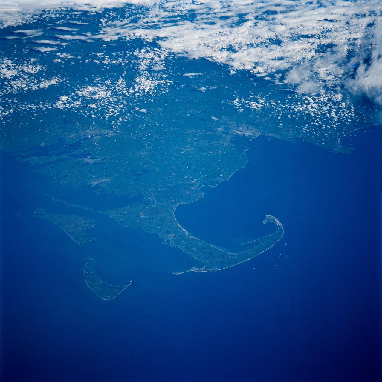
iss055e023781 (April 14, 2018) --- New York state's Long Island and the Atlantic Ocean coasts of New Jersey, Connecticut and Rhode Island are pictured from the International Space Station as it orbited over the eastern coast of the United States.
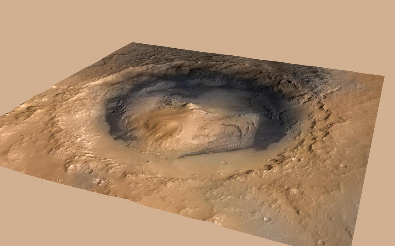
NASA Curiosity rover landed in the Martian crater known as Gale Crater, which is approximately the size of Connecticut and Rhode Island combined. A green dot shows where the rover landed, well within its targeted landing ellipse, outlined in blue.
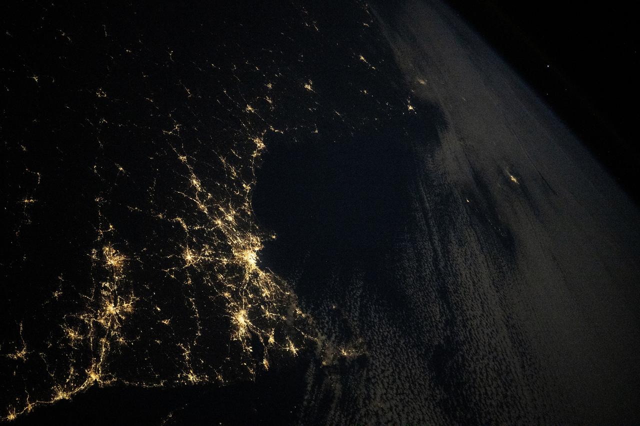
iss072e186812 (Nov. 14, 2024) --- The city lights along the New England coast of the United States including New Haven, Connecticut; Providence, Rhode Island; and Boston, Massachusetts, are pictured from the United States as it orbited 254 miles above the Atlantic Ocean.
iss062e046805 (Feb. 22, 2020) --- This oblique view of the northeastern United States highlights the coasts (left to right) of Massachusetts, Rhode Island, Connecticut, New York and New Jersey. The International Space Station was orbiting 265 miles above the Atlantic Ocean when this photograph was taken by an Expedition 62 crewmember.

ISS030-E-078095 (6 Feb. 2012) --- One of the Expedition 30 crew members aboard the International Space Station took this nighttime photograph of much of the eastern (Atlantic) coast of the United States. Large metropolitan areas and other easily recognizable sites from the Virginia/Maryland/Washington, D.C. area spanning almost to Rhode Island are visible in the scene. Boston is just out of frame at right. Long Island and the Greater Metropolitan area of New York City are visible in the lower right quadrant. Large cities in Pennsylvania (Philadelphia and Pittsburgh) are near center. Parts of two Russian vehicles parked at the orbital outpost are seen in left foreground.
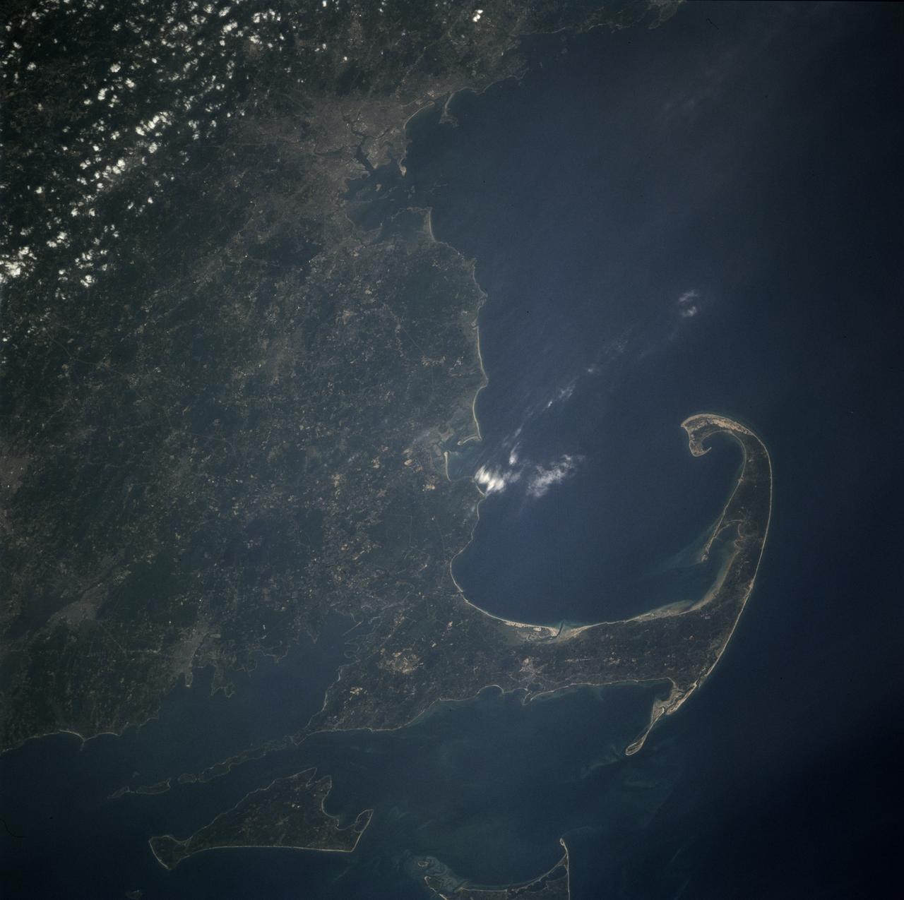
STS071-708-040 (27 June-7 July 1995) --- This view shows Cape Cod in some detail in the center right of the view. Provincetown lies on the inside of the hook of Cape Cod. Other larger cities are unusually easy to see on this frame. The Boston metropolitan area is the large gray area at the top (north), with a smaller gray patch immediately south indicating Brockton, Massachusetts. Other smaller patches in southern Massachusetts (bottom left) indicate Fall River (far left) and New Bedford in the coast on the north side of Buzzard's Bay. The outskirts of Providence, Rhode Island appear half way up the left edge of the frame. The islands at the bottom of the frame are Martha's Vineyard (bottom left) and Nantucket Island (partial view). Shoals (near-surface sand bars) appear as light-blue swirls on the shallow sea bottom between Cape Cod and these islands. The distance from Boston to Nantucket is almost 100 miles.
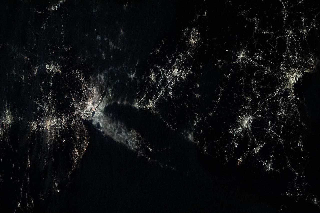
iss070e098484 (Feb., 23, 2024) --- This nightime view shows major northeastern U.S. urban centers including a cloudy New York City; Philadelphia, Pennsylvania; Providence, Rhode Island; Boston Massachussetts; and more. Expedition 70 Flight Engineer Loral O'Hara of NASA photographed the area as the International Space Station orbited 262 miles above the Gulf of Maine.
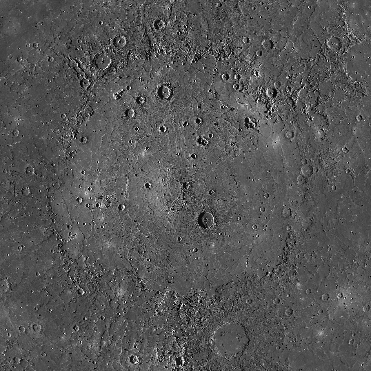
This is an MDIS mosaic of the mighty Caloris basin, Mercury's youngest large impact basin. Caloris has been filled by volcanic plains that are distinctive in color from the surrounding terrain. Subsequent craters have excavated low-reflectance material from beneath these volcanic plains, possibly giving clues to the composition of the basin floor. The basin interior has a complex tectonic history. The interior smooth plains have an area approximately the area of Alaska! Over 640 Rhode Islands would fit inside of this massive basin. http://photojournal.jpl.nasa.gov/catalog/PIA19213
STS084-703-003 (15-24 May 1997) --- Cape Cod extends 105 kilometers (65 miles) into the Atlantic Ocean. To the south of Cape Cod are the islands of Martha's Vineyard (west) and Nantucket (east). The city of Boston can be seen surrounding the bay above the "hook" on Cape Cod. To the south are the cities of New Bedford on Buzzards Bay, and Providence, Rhode Island. The Cape Cod Canal is an artificial waterway that connects Buzzards Bay and Cape Cod Bay. The waterway is 28 kilometers (17.5 miles) and does not contains locks. The canal was built to shorten the distance over water between New York City and Boston. In 1620 the Pilgrims landed at Provincetown, on the upper tip of Cape Cod, before they proceeded to Plymouth.
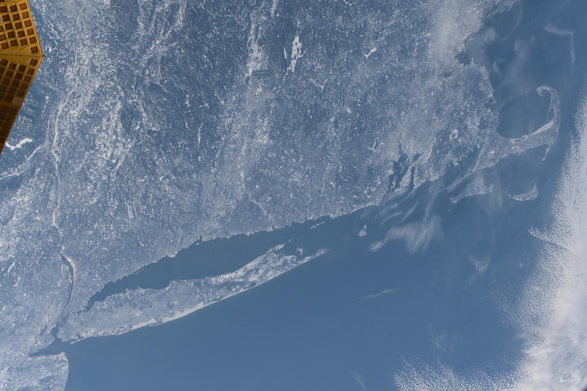
iss074e0300237 (Feb. 2, 2026) --- The wintry landscape from New Jersey to Massachusetts is seen from the International Space Station as it orbited 262 miles above the northeastern United States. Temperatures in New York City (lower left) ranged from a low of about 18 degrees Fahrenheit to a high of around 30 degrees when this photograph was taken.
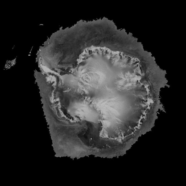
A rift in Antarctica's Larsen C ice shelf has grown to 110 miles (175 km) long, making it inevitable that an iceberg larger than Rhode Island will soon calve from the ice shelf. Larsen C is the fourth largest ice shelf in Antarctica, with an area of almost 20,000 square miles (50,000 square kilometers). The calving event will remove approximately 10 percent of the ice shelf's mass, according to the Project for Impact of Melt on Ice Shelf Dynamics and Stability (MIDAS), a UK-based team studying the ice shelf. Only 12 miles (20 km) of ice now separates the end of the rift from the ocean. The rift has grown at least 30 miles (50 km) in length since August, but appears to be slowing recently as Antarctica returns to polar winter. Project MIDAS reports that the calving event might destabilize the ice shelf, which could result in a collapse similar to what occurred to the Larsen B ice shelf in 2002. The Multi-angle Imaging SpectroRadiometer (MISR) instrument aboard NASA's Terra satellite captured views of Larsen C on August 22, 2016, when the rift was 80 miles (130 km) in length; December 8, 2016, when the rift was approximately 90 miles (145 km) long; and April 6, 2017. The MISR instrument has nine cameras, which view the Earth at different angles. The overview image, from December 8, shows the entire Antarctic Peninsula -- home to Larsen A, B, and C ice shelves -- in natural color (similar to how it would appear to the human eye) from MISR's vertical-viewing camera. Combining information from several MISR cameras pointed at different angles gives information about the texture of the ice. The accompanying GIF depicts the inset area shown on the larger image and displays data from all three dates in false color. These multiangular views -- composited from MISR's 46-degree backward-pointing camera, the nadir (vertical-viewing) camera, and the 46-degree forward-pointing camera -- represent variations in ice texture as changes in color, such that areas of rough ice appear orange and smooth ice appears blue. The Larsen C shelf is on the left in the GIF, bordered by the Weddell Sea on the upper right. The ice within the rift is orange, indicating movement, and the end of the rift can be tracked across the shelf between images. In addition, between December and April, the rift widened, pushing the future iceberg away from the shelf at its southern end. These data were acquired during Terra orbits 88717, 90290 and 92023. https://photojournal.jpl.nasa.gov/catalog/PIA21581
ISS034-E-48455 (14 Feb. 2013) --- Looking out at Earth?s surface from the International Space Station (ISS), astronauts and cosmonauts frequently observe sunglint highlighting both ocean and inland water surfaces. The Atlantic Ocean, including Cape Cod Bay and Buzzards Bay, along the coastlines of Massachusetts and Rhode Island, has a burnished, mirror-like appearance in this image. This is due to sunlight reflected off the water surface back towards the station crew member who took the photo. The peak reflection point is towards the right side of the image, lending the waters of Long Island Sound and the upper Massachusetts coastline an even brighter appearance. Sunglint also illuminates the surface waters of Chesapeake Bay, located over 400 kilometers (250 miles) to the southwest of the tip of Long Island. This suggests that the Sun was low on the horizon due to the observed extent of the sunglint effect. The time of image acquisition, approximately 4:26 p.m. Eastern Standard Time, was about one hour before local sunset. There is little in this image to indicate that the region was still recovering from a major winter storm that dropped almost one meter (three feet) of snow over much of the northeastern USA less than a week earlier. The high viewing angle from the space station also allows Earth?s curvature, or limb, to be seen; blue atmospheric layers gradually fade into the darkness of space across the top part of the image. Low clouds near Cape Cod, Long Island, and further down the Atlantic coastline cast shadows over the water surfaces, reducing the sunglint in some areas.
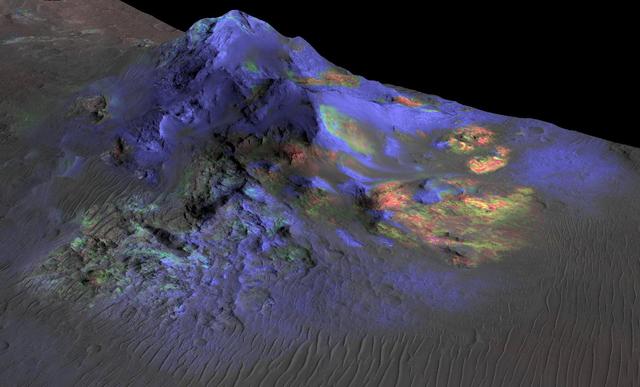
Deposits of impact glass have been preserved in Martian craters, including Alga Crater, shown here. Detection of the impact glass by researchers at Brown University, Providence, Rhode Island, is based on data from the Compact Reconnaissance Imaging Spectrometer for Mars (CRISM) on NASA's Mars Reconnaissance Orbiter. In color coding based on analysis of CRISM spectra, green indicates the presence of glass. (Blues are pyroxene; reds are olivine.) Impact glass forms in the heat of a violent impact that excavates a crater. Impact glass found on Earth can preserve evidence about ancient life. A deposit of impact glass on Mars could be a good place to look for signs of past life on that planet. This view shows Alga Crater's central peak, which is about 3 miles (5 kilometers) wide within the 12-mile (19-kilometer) diameter of this southern-hemisphere crater. The information from CRISM is shown over a terrain model and image, based on observations by the High Resolution Imaging Science Experiment (HiRISE) camera. The vertical dimension is exaggerated by a factor of two. http://photojournal.jpl.nasa.gov/catalog/PIA19673

A Mod-1 2000-kilowatt wind turbine designed by National Aeronautics and Space Administration (NASA) Lewis Research Center and constructed in Boone, North Carolina. The wind turbine program was a joint program between NASA and the Energy Research and Development Administration (ERDA) during the 1970s to develop less expensive forms of energy. NASA Lewis was assigned the responsibility of developing large horizontal-axis wind turbines. The program included a series of increasingly powerful wind turbines, designated: Mod-0A, Mod-1, WTS-4, and Mod-5. The program’s first device was a Mod-0 100-kilowatt wind turbine test bed at NASA’s Plum Brook Station. There were four Mod-0A 200-kilowatt turbines built in New Mexico, Hawaii, Puerto Rico, and Rhode Island. The 2000-kilowatt wind turbine in North Carolina, seen here, was the only Mod-1 machine constructed. The two-bladed, 200-foot diameter device was built in May 1979 and began operation that September. The Mod-1 turbine performed exceedingly well and was fully integrated into the local power grid. NASA researchers also used the North Carolina device to study its effect on noise and television transmission.

Taken on October 22, 2015 at 0400 UTC by the Suomi NPP satellite's VIIRS sensor, this colorized infrared image shows the extremely large eye of Typhoon Champi. With a diameter of 60 nautical miles, the eye of the storm is larger than the state of Rhode Island. Typhoon Champi is currently 700 nautical miles south of Tokyo, Japan with 110mph sustained winds, and is moving northeast with no threat to land. Credit: NASA/NOAA via <b><a href="www.nnvl.noaa.gov/" rel="nofollow"> NOAA Environmental Visualization Laboratory</a></b> <b><a href="http://www.nasa.gov/audience/formedia/features/MP_Photo_Guidelines.html" rel="nofollow">NASA image use policy.</a></b> <b><a href="http://www.nasa.gov/centers/goddard/home/index.html" rel="nofollow">NASA Goddard Space Flight Center</a></b> enables NASA’s mission through four scientific endeavors: Earth Science, Heliophysics, Solar System Exploration, and Astrophysics. Goddard plays a leading role in NASA’s accomplishments by contributing compelling scientific knowledge to advance the Agency’s mission. <b>Follow us on <a href="http://twitter.com/NASAGoddardPix" rel="nofollow">Twitter</a></b> <b>Like us on <a href="http://www.facebook.com/pages/Greenbelt-MD/NASA-Goddard/395013845897?ref=tsd" rel="nofollow">Facebook</a></b> <b>Find us on <a href="http://instagrid.me/nasagoddard/?vm=grid" rel="nofollow">Instagram</a></b>
TA Mod-0A 200-kilowatt wind turbine designed by National Aeronautics and Space Administration (NASA) Lewis Research Center and constructed in Clayton, New Mexico. The wind turbine program was a joint effort by NASA and the Energy Research and Development Administration (ERDA) during the 1970s to develop less expensive forms of energy. NASA Lewis was assigned the responsibility of developing large horizontal-axis wind turbines. The program included a series of increasingly powerful wind turbines, designated: Mod-0A, Mod-1, WTS-4, and Mod-5. The program’s first device was a Mod-0 100-kilowatt wind turbine test bed built at NASA’s Plum Brook Station. This Mod-0A 200-kilowatt turbine built in Clayton in 1977 was the program’s second device. It included a 125-foot long blade atop a 100-foot tall tower. The Mod-0A was designed to determine the turbine’s operating problems, integrate the system with the local utilities, and assess the attitude of the local community. There were additional Mod-0A turbines built in Culebra, Puerto Rico; Block Island, Rhode Island; and Oahu, Hawaii. The Mod-0A turbines were initially unreliable and suffered issues with the durability of the rotor blade. Lewis engineers addressed the problems, and the wind turbines proved to be reliable and efficient devices that operated for a number of years. The information gained from these early models was vital to the design and improvement of the later generations.

The U.S. National Weather Service called it a “a crippling and historic winter blizzard.” In late January 2015, transportation systems from Trenton to Portland were shut down, and more than 35 million people hunkered down for extreme snowfall and biting winds. For those in New England, it turned out to be a monstrous storm. For the Mid-Atlantic region, not so much. Vast swaths of Massachusetts, Connecticut, Rhode Island, New Hampshire, Maine, and Long Island (NY) were blanketed with 15 to 25 inches (40 to 60 centimeters) of snow as of midday on January 27, 2015, and snow was expected to continue into January 28. Sustained winds reached gale force, with hurricane-force gusts along the coastlines. Storm surges sent ice and water into the streets of Scituate and Nantucket, Massachusetts. Many New England towns, including the city of Boston, were expected to approach all-time snowfall records. The Visible Infrared Imaging Radiometer Suite on the Suomi NPP satellite acquired these nighttime images at 1:45 am US eastern standard time (06:45 Universal Time) on January 27, 2015. The top image, lit by moonlight and city lights, shows a nor'easter off the coast of the East Coast of the United States. City lights are blurred somewhat by the cloud cover. The second image shows the same scene in longwave infrared radiation, with brighter shades representing the colder temperatures of snow-producing clouds. NASA Earth Observatory image by Jesse Allen, using VIIRS data from the Suomi National Polar-orbiting Partnership. Read more: <a href="http://earthobservatory.nasa.gov/IOTD/view.php?id=85166&eocn=home&eoci=iotd_title" rel="nofollow">earthobservatory.nasa.gov/IOTD/view.php?id=85166&eocn...</a> Via: <b><a href="http://www.earthobservatory.nasa.gov/" rel="nofollow"> NASA Earth Observatory</a></b> <b><a href="http://www.nasa.gov/audience/formedia/features/MP_Photo_Guidelines.html" rel="nofollow">NASA image use policy.</a></b> <b><a href="http://www.nasa.gov/centers/goddard/home/index.html" rel="nofollow">NASA Goddard Space Flight Center</a></b> enables NASA’s mission through four scientific endeavors: Earth Science, Heliophysics, Solar System Exploration, and Astrophysics. Goddard plays a leading role in NASA’s accomplishments by contributing compelling scientific knowledge to advance the Agency’s mission. <b>Follow us on <a href="http://twitter.com/NASAGoddardPix" rel="nofollow">Twitter</a></b> <b>Like us on <a href="http://www.facebook.com/pages/Greenbelt-MD/NASA-Goddard/395013845897?ref=tsd" rel="nofollow">Facebook</a></b> <b>Find us on <a href="http://instagram.com/nasagoddard?vm=grid" rel="nofollow">Instagram</a></b>

The U.S. National Weather Service called it a “a crippling and historic winter blizzard.” In late January 2015, transportation systems from Trenton to Portland were shut down, and more than 35 million people hunkered down for extreme snowfall and biting winds. For those in New England, it turned out to be a monstrous storm. For the Mid-Atlantic region, not so much. Vast swaths of Massachusetts, Connecticut, Rhode Island, New Hampshire, Maine, and Long Island (NY) were blanketed with 15 to 25 inches (40 to 60 centimeters) of snow as of midday on January 27, 2015, and snow was expected to continue into January 28. Sustained winds reached gale force, with hurricane-force gusts along the coastlines. Storm surges sent ice and water into the streets of Scituate and Nantucket, Massachusetts. Many New England towns, including the city of Boston, were expected to approach all-time snowfall records. The Visible Infrared Imaging Radiometer Suite on the Suomi NPP satellite acquired these nighttime images at 1:45 am US eastern standard time (06:45 Universal Time) on January 27, 2015. The top image, lit by moonlight and city lights, shows a nor'easter off the coast of the East Coast of the United States. City lights are blurred somewhat by the cloud cover. The second image shows the same scene in longwave infrared radiation, with brighter shades representing the colder temperatures of snow-producing clouds. NASA Earth Observatory image by Jesse Allen, using VIIRS data from the Suomi National Polar-orbiting Partnership. Read more: <a href="http://earthobservatory.nasa.gov/IOTD/view.php?id=85166&eocn=home&eoci=iotd_title" rel="nofollow">earthobservatory.nasa.gov/IOTD/view.php?id=85166&eocn...</a> Via: <b><a href="http://www.earthobservatory.nasa.gov/" rel="nofollow"> NASA Earth Observatory</a></b> <b><a href="http://www.nasa.gov/audience/formedia/features/MP_Photo_Guidelines.html" rel="nofollow">NASA image use policy.</a></b> <b><a href="http://www.nasa.gov/centers/goddard/home/index.html" rel="nofollow">NASA Goddard Space Flight Center</a></b> enables NASA’s mission through four scientific endeavors: Earth Science, Heliophysics, Solar System Exploration, and Astrophysics. Goddard plays a leading role in NASA’s accomplishments by contributing compelling scientific knowledge to advance the Agency’s mission. <b>Follow us on <a href="http://twitter.com/NASAGoddardPix" rel="nofollow">Twitter</a></b> <b>Like us on <a href="http://www.facebook.com/pages/Greenbelt-MD/NASA-Goddard/395013845897?ref=tsd" rel="nofollow">Facebook</a></b> <b>Find us on <a href="http://instagram.com/nasagoddard?vm=grid" rel="nofollow">Instagram</a></b>
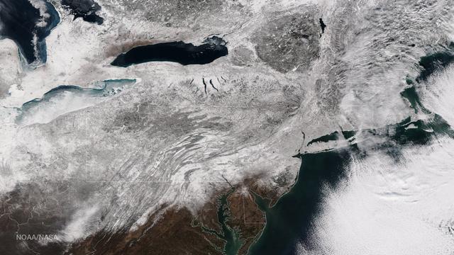
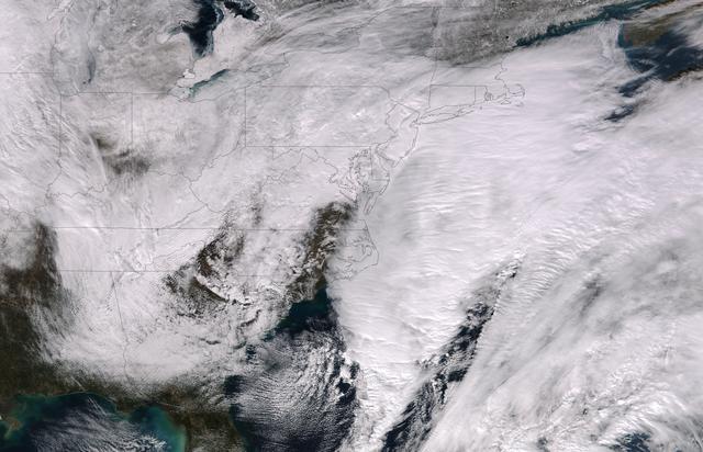
As the storm moves offshore and the skies clear over the Northeast United States, the extent of snowfall from the blizzard is shown in this image from the Suomi NPP satellite imagery, taken on January 28, 2015 at 1:50 EST. Portions of Suffolk County, New York and parts of eastern and southern New England, including areas in and around Portland, Maine, Boston, Massachusetts, and Providence, Rhode Island, received more than 20 inches of snowfall. Up to 36 inches of snow were reported in Auburn, Hudson and Lunenburg, Massachusetts. Credit: NASA/NOAA/NPP/VIIRS Via: <b><a href="www.nnvl.noaa.gov/" rel="nofollow"> NOAA Environmental Visualization Laboratory</a></b> <b><a href="http://www.nasa.gov/audience/formedia/features/MP_Photo_Guidelines.html" rel="nofollow">NASA image use policy.</a></b> <b><a href="http://www.nasa.gov/centers/goddard/home/index.html" rel="nofollow">NASA Goddard Space Flight Center</a></b> enables NASA’s mission through four scientific endeavors: Earth Science, Heliophysics, Solar System Exploration, and Astrophysics. Goddard plays a leading role in NASA’s accomplishments by contributing compelling scientific knowledge to advance the Agency’s mission. <b>Follow us on <a href="http://twitter.com/NASAGoddardPix" rel="nofollow">Twitter</a></b> <b>Like us on <a href="http://www.facebook.com/pages/Greenbelt-MD/NASA-Goddard/395013845897?ref=tsd" rel="nofollow">Facebook</a></b> <b>Find us on <a href="http://instagram.com/nasagoddard?vm=grid" rel="nofollow">Instagram</a></b>

Storm in the Sargasso Sea Scientist aboard the R/V Endeavor in the Sargasso Sea put their research on hold on July 28, 2014, as a storm system brought high waves crashing onto the deck. NASA's Ship-Aircraft Bio-Optical Research (SABOR) experiment is a coordinated ship and aircraft observation campaign off the Atlantic coast of the United States, an effort to advance space-based capabilities for monitoring microscopic plants that form the base of the marine food chain. Read more: <a href="http://1.usa.gov/WWRVzj" rel="nofollow">1.usa.gov/WWRVzj</a> Credit: NASA/SABOR/Chris Armanetti, University of Rhode Island .<b><a href="http://www.nasa.gov/audience/formedia/features/MP_Photo_Guidelines.html" rel="nofollow">NASA image use policy.</a></b> <b><a href="http://www.nasa.gov/centers/goddard/home/index.html" rel="nofollow">NASA Goddard Space Flight Center</a></b> enables NASA’s mission through four scientific endeavors: Earth Science, Heliophysics, Solar System Exploration, and Astrophysics. Goddard plays a leading role in NASA’s accomplishments by contributing compelling scientific knowledge to advance the Agency’s mission. <b>Follow us on <a href="http://twitter.com/NASAGoddardPix" rel="nofollow">Twitter</a></b> <b>Like us on <a href="http://www.facebook.com/pages/Greenbelt-MD/NASA-Goddard/395013845897?ref=tsd" rel="nofollow">Facebook</a></b> <b>Find us on <a href="http://instagram.com/nasagoddard?vm=grid" rel="nofollow">Instagram</a></b>
This image was taken by the Suomi NPP satellite's VIIRS instrument at 1825Z on January 26, 2015. A low pressure system currently forming off the mid-Atlantic coast will rapidly strengthen into a major nor'easter today and affect parts of the Northeast U.S. through early Wednesday. This system will be responsible for heavy to intense snowfall and strong winds, with blizzard conditions expected from eastern New Jersey to eastern Massachusetts where Blizzard Warnings are in effect. Accumulations will likely exceed one foot from eastern New Jersey through eastern Maine by late Tuesday. The heaviest snow accumulations, perhaps exceeding two feet, are forecast across portions of Connecticut, Rhode Island and Massachusetts, including the Boston area. Currently, New York City is forecast to receive 18-24 inches of snow, and Boston is forecast to receive 24-36 inches of snow. Wind gusts of 45 to 60 mph will be common from eastern New Jersey to eastern Massachusetts, leading to widespread blizzard conditions. Wind gusts up to 70 mph are possible in far eastern Massachusetts, including Cape Cod and Nantucket. Credit: NASA/NOAA/NPP/VIIRS Via: NASA/NOAA via <b><a href="www.nnvl.noaa.gov/" rel="nofollow"> NOAA Environmental Visualization Laboratory</a></b> <b><a href="http://www.nasa.gov/audience/formedia/features/MP_Photo_Guidelines.html" rel="nofollow">NASA image use policy.</a></b> <b><a href="http://www.nasa.gov/centers/goddard/home/index.html" rel="nofollow">NASA Goddard Space Flight Center</a></b> enables NASA’s mission through four scientific endeavors: Earth Science, Heliophysics, Solar System Exploration, and Astrophysics. Goddard plays a leading role in NASA’s accomplishments by contributing compelling scientific knowledge to advance the Agency’s mission. <b>Follow us on <a href="http://twitter.com/NASAGoddardPix" rel="nofollow">Twitter</a></b> <b>Like us on <a href="http://www.facebook.com/pages/Greenbelt-MD/NASA-Goddard/395013845897?ref=tsd" rel="nofollow">Facebook</a></b> <b>Find us on <a href="http://instagram.com/nasagoddard?vm=grid" rel="nofollow">Instagram</a></b>