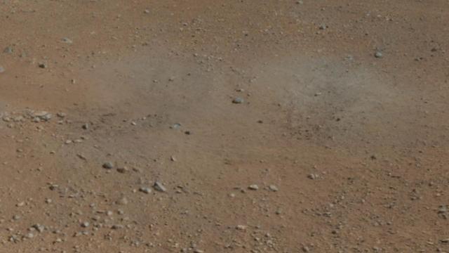
This cut-out from a color panorama image taken by NASA Curiosity rover shows the effects of the descent stage rocket engines blasting the ground. It comes from the right side of the thumbnail panorama obtained the Mast Camera.
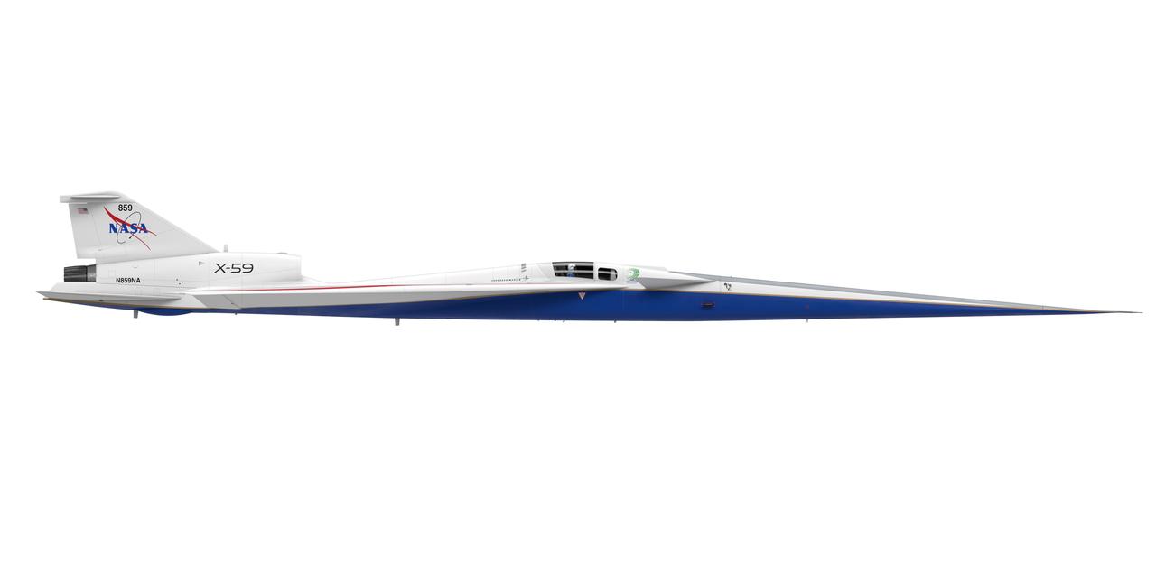
Artist concept of the X-59 side view (right side)
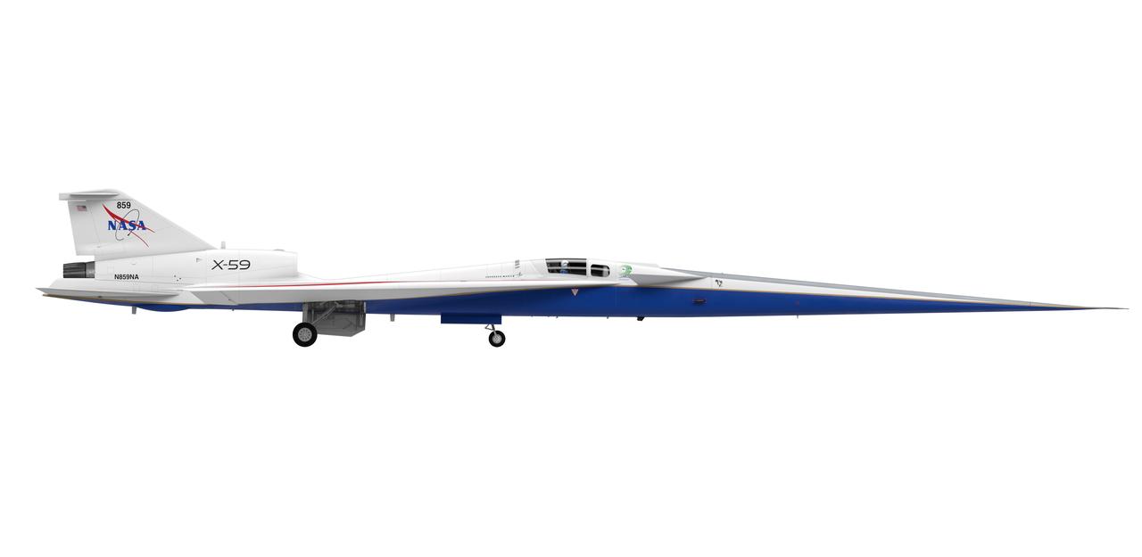
Artist concept of the X-59 side view (right side) with landing gears down.

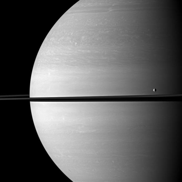
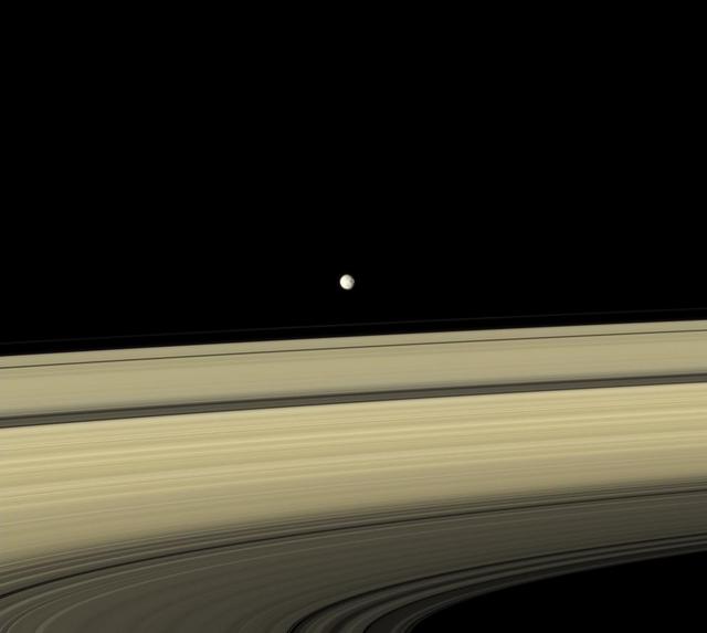
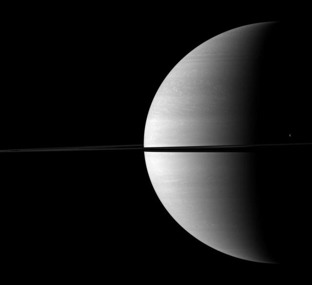
Cassini stares toward the night side of Saturn, seen here on the right, as the active icy moon Enceladus glides past
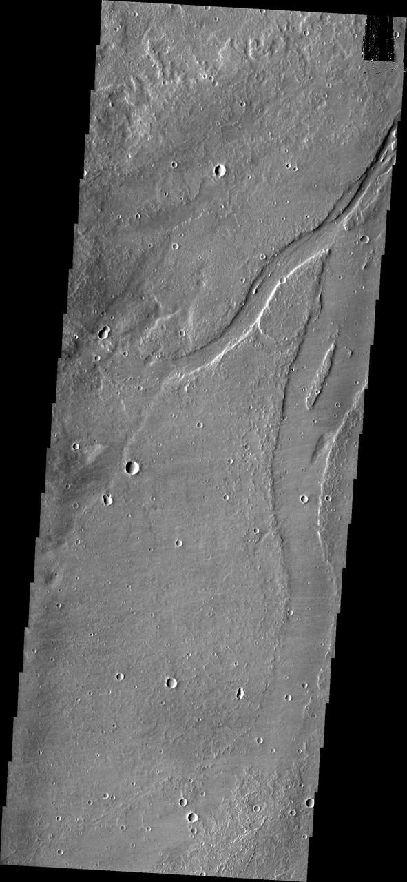
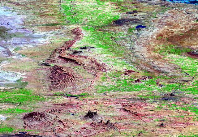
The channel on the right side of this image from NASA 2001 Mars Odyssey spacecraft is located in the volcanic plains southeast of Alba Mons.
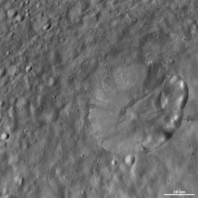
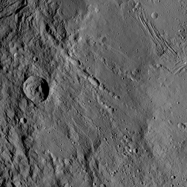
This image from NASA Dawn spacecraft of asteroid Vesta shows Octavia crater, located in Vesta Marcia quadrangle, just south of Vesta equator. Octavia rim is fresher on the right side and more degraded on the left side.

In this side-by-side visualization, Pacific Ocean sea surface height anomalies during the 1997-98 El Niño left are compared with 2015 Pacific conditions right.

This side-by-side image shows a Cassini radar image on the left of what is the largest body of liquid ever found on Titan north pole, compared to Lake Superior on the right
The moon Tethys occupies the right foreground of this Saturnian scene. This view from NASA Cassini spacecraft looks toward the anti-Saturn side of Tethys and toward the northern, sunlit side of the rings from just above the ringplane.

Global map of crustal thickness of the moon derived from gravity data obtained by NASA GRAIL spacecraft. The lunar near side is represented on the left hemisphere. The far side is represented in the right hemisphere.
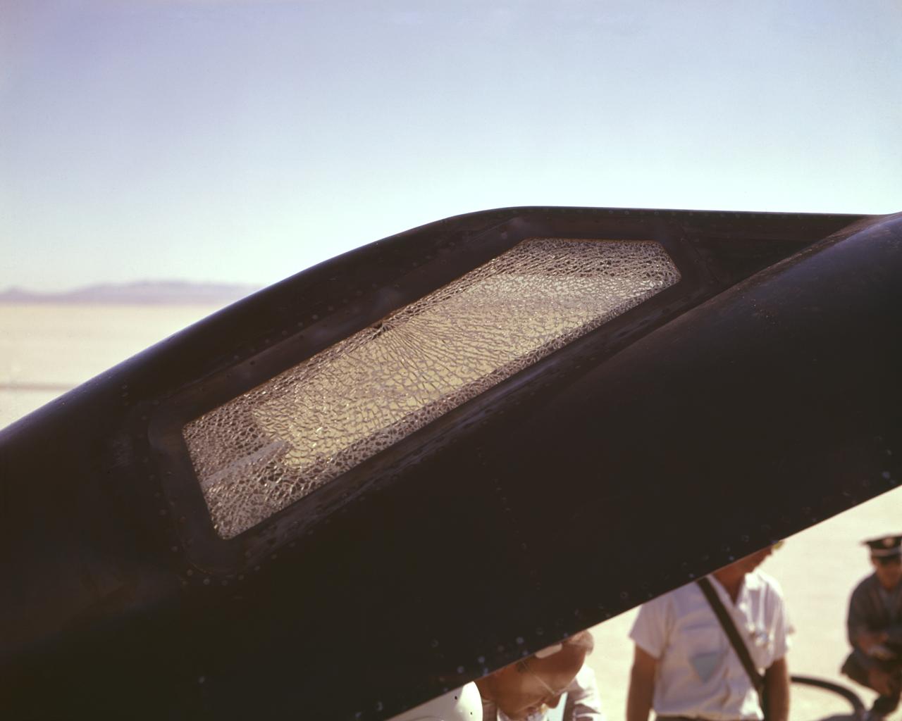
Cracked canopy glass on right side of X-15 #2 after flt. 2-21-37 on Nov. 9 1961. Robert White-pilot. First flight to mach 6.
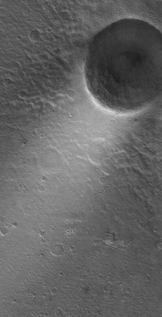
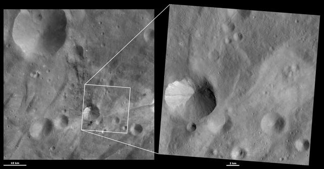
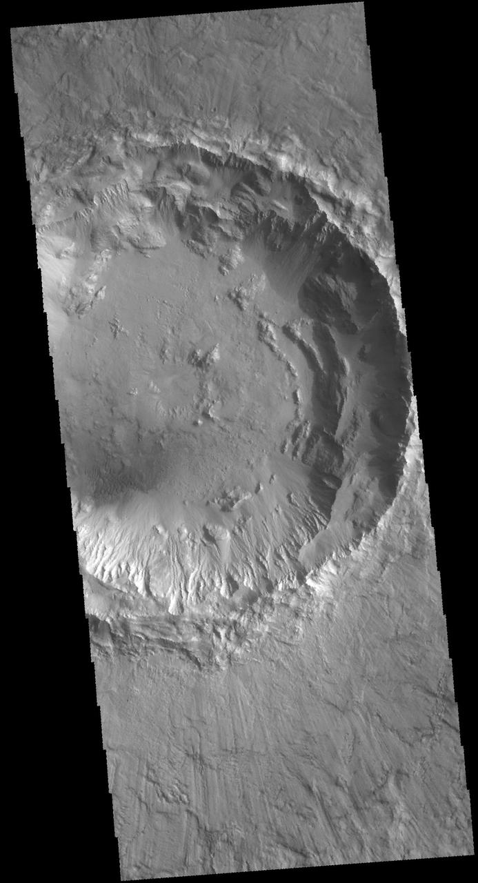
The crater on the right side of this image is affecting the local wind regime. Note the bright line of clouds streaming off the north rim of the crater
Gray Mimas appears to hover above the colorful rings. The large crater seen on the right side of the moon is named for William Herschel, who discovered Mimas in 1789.

This 3-D perspective view looks south along the southeast coast of the North Island of New Zealand. The capital city of Wellington is off the right side of the image.
This image from NASA Dawn spacecraft shows numerous grooves linear depressions and crater chains, especially in the right hand side of the image of asteroid Vesta.
This image shows two side-by-side streaks of wispy, white clouds against a dark gray sky moving from the middle of the frame toward the left. To their right are several fainter, laterally extending rays of wispy clouds moving in the same direction.

This image from NASA Wide-field Infrared Survey Explorer, shows three different nebulae located in the constellation of Perseus. NGC 1491 is seen on the right side of the image, SH 2-209 is on the left side and BFS 34 lies in between.
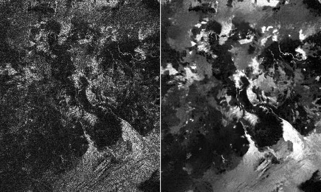
Presented here are side-by-side comparisons of a traditional Cassini Synthetic Aperture Radar (SAR) view, at left, and one made using a new technique for handling electronic noise that results in clearer views of Titan's surface, at right. The technique, called despeckling, produces images that can be easier for researchers to interpret. The terrain seen here is in the flow region named Leilah Fluctus (55 degrees north, 80 degrees west). With the speckle noise suppressed, the overall pattern of bright and dark in the scene becomes more apparent. In particular, cone-shaped features near lower right stand out, which could be alluvial analogues on Titan -- features produced by the action of rivers or floods. North is toward right in this image, which shows an area about 50 miles (80 kilometers) wide. http://photojournal.jpl.nasa.gov/catalog/PIA19054
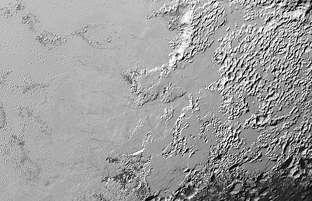
Ice (probably frozen nitrogen) that appears to have accumulated on the uplands on the right side of this 390-mile (630-kilometer) wide image is draining from Pluto's mountains onto the informally named Sputnik Planum through the 2- to 5-mile (3- to 8- kilometer) wide valleys. The flow front of the ice moving into Sputnik Planum is outlined by the blue arrows. The origin of the ridges and pits on the right side of the image remains uncertain. http://photojournal.jpl.nasa.gov/catalog/PIA19944

The Bell Aircraft Corporation X-1-2 aircraft on the ramp at NACA High Speed Flight Research Station located on the South Base of Muroc Army Air Field in 1947. The X-1-2 flew until October 23, 1951, completing 74 glide and powered flights with nine different pilots. The aircraft has white paint and the NACA tail band. The black Xs are reference markings for tracking purposes. They were widely used on NACA aircraft in the early 1950s.
jsc2023e013698 (Feb. 9, 2023) --- A preflight image showing the inside of the Exploration Potable Water Dispenser (Exploration PWD) with a partial panel removed. Exploration PWD is a device that dispenses ambient and hot water into crew food and drink bags. The Exploration PWD is an improvement to the International Space Station (ISS) legacy PWD. Successful demonstration of this technology could lead to its adoption for future exploration missions and continued use for the space station crew.
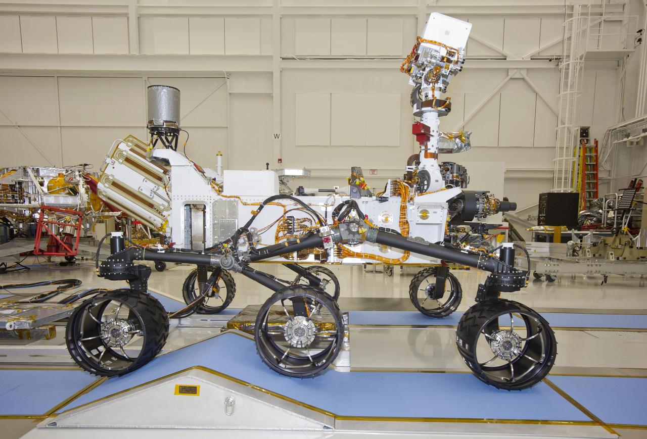
This photograph of the NASA Mars Science Laboratory rover, Curiosity, was taken during mobility testing on June 3, 2011. The location is inside the Spacecraft Assembly Facility at NASA Jet Propulsion Laboratory, Pasadena, Calif.

Off the image to the right is Yuty Crater, located between Simud and Tiu Valles. The crater ejcta forms the large lobes along the right side of this VIS image. This type of ejecta was created by surface flow rather than air fall. It is thought that the near surface materials contained volatiles (like water) which mixed with the ejecta at the time of the impact. Orbit Number: 68736 Latitude: 22.247 Longitude: 325.213 Instrument: VIS Captured: 2017-06-12 17:57 https://photojournal.jpl.nasa.gov/catalog/PIA22303
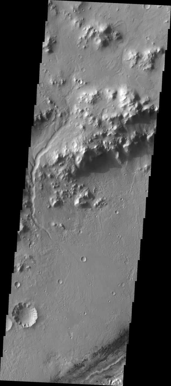
Nili Fossae, a series of tectonic fractures, is the low region on the right side of this image captured by NASA Mars Odyssey. A small channel is visible draining into the large tectonic depression.
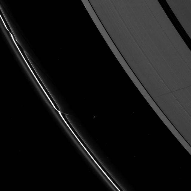
Although the embedded moon Pan is nowhere to be seen, there is a bright clump-like feature visible here, within the Encke Division. Also discernable are periodic brightness variations along the outer right side gap edge
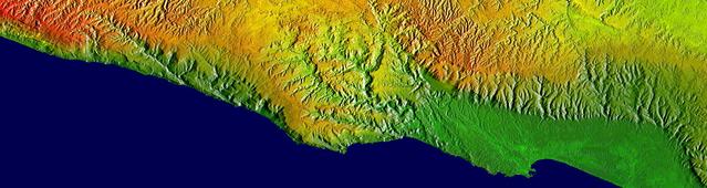
This elevation map shows a part of the southern coast of the Arabian Peninsula including parts of the countries of Oman and Yemen. The narrow coastal plain on the right side of the image includes the city of Salahlah, the second largest city in Oman.
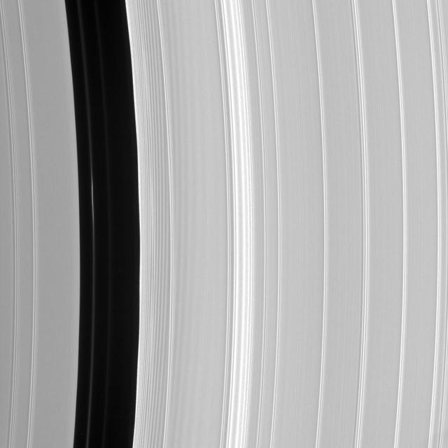
A bright spoke extends across the unilluminated side of Saturn B ring about the same distance as that from London to Cairo. The background ring material displays some azimuthal i.e., left to right asymmetry
This image from NASA 2001 Mars Odyssey spacecraft of Daedalia Planum shows the termination or end of a single flow. In this case it is the end of the brighter/rougher flow on the right side of the image.
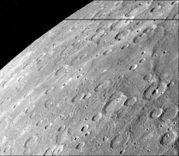
Antoniadi Ridge, over 450 kilometers long, runs along the right side of this acquired image during NASA Mariner 10 first encounter with Mercury after its launch in 1974.
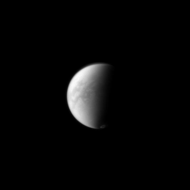
NASA Cassini spacecraft simultaneously peers through the haze in Titan equatorial region down to its surface and captures the vortex of clouds hovering over its south pole just to the right of the terminator on the moon dark side.
This MOC image shows a wind streak created in the lee -- the downwind side -- of a crater in far eastern Chryse Planitia. The winds responsible for the formation of the streak blew from the upper right northeast to the lower left southwest
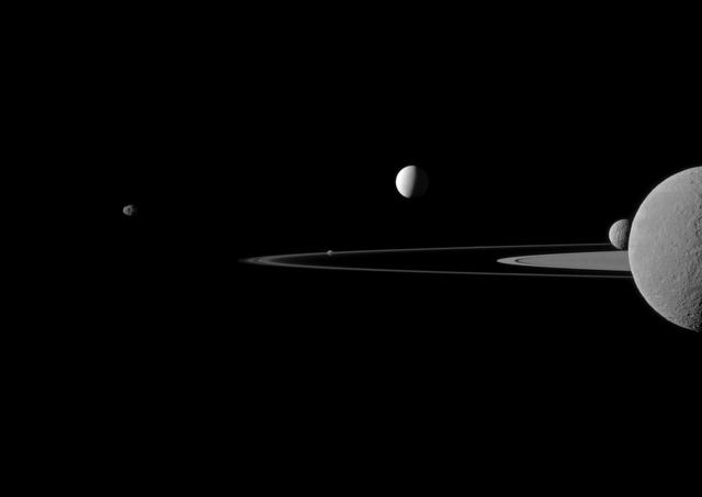
NASA Cassini spacecraft observes three of Saturn moons set against the darkened night side of the planet. Seen here are Rhea, closest to Cassini, Enceladus to right of Rhea, and Dione, left of Rhea.
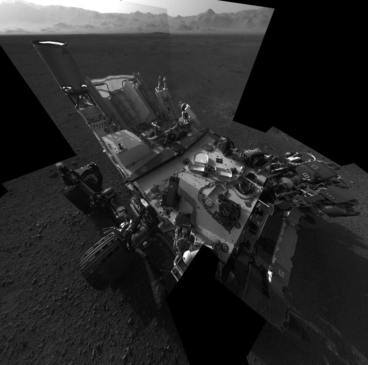
This full-resolution self-portrait shows the deck of NASA Curiosity rover. The back of the rover can be at top left, two of the right side wheels at left, and the undulating rim of Gale Crater forms the lighter color strip in the background.
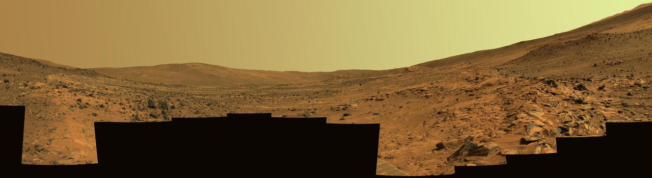
This panorama shows two reddish-brown, rock-strewn slopes on the left and right sides of a broad, U-shaped dip in the middle. In the distance are the broad slopes of McCool Hill. Above that is an orangish-yellow sky.

Do you see what I see in this image from NASA Mars Odyssey spacecraft? There is a mickey mouse hat sitting on the top right side of this daytime infrared image.

In the lower center of this perspective view of upstate New York, the city of Syracuse hugs the southeastern banks top right side of Lake Onondaga, the smaller of the two dark features that dominate the scene.
NASA Mars Exploration Rover Opportunity recorded this view of the western edge of Cape York, a segment of the rim of Endeavour Crater. A bright vein, informally named Homestake, is visible on the right side of the image.
This image from NASA 2001 Mars Odyssey spacecraft of Daedalia Planum shows the termination or end of a single flow. In this case it is the end of the brighter/rougher flow on the right side of the image.
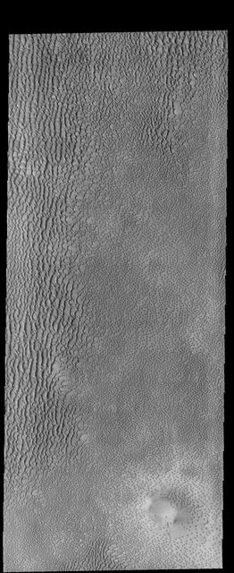
This image captured by NASA 2001 Mars Odyssey spacecraft shows part of Aspledon Undae, a region of dunes near the north pole. The right side of the image shows hundreds of small, isolated dunes.
This image captured by NASA 2001 Mars Odyssey spacecraft contains the landing site in the bottom right portion of the image, near the dark dunes. Note the channel that cuts through the crater rim on the left side of the image.
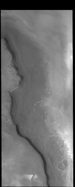
The cliff face in this image captured by NASA 2001 Mars Odyssey spacecraft is called Rupes Tenius rupes = scarp. The polar cap is the higher region to the left and the plains are located on the right side of the image.
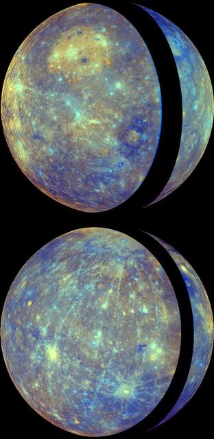
NASA MESSENGER shows the thin crescent of Mercury during approach forming the right portion of the globe and the fuller departure view showing Caloris basin forming the left side and majority of the view.
The moon Tethys stands out as a tiny crescent of light in front of the dark of Saturn night side. Tethys can be seen above the ringplane on the far right of this NASA Cassini spacecraft image.
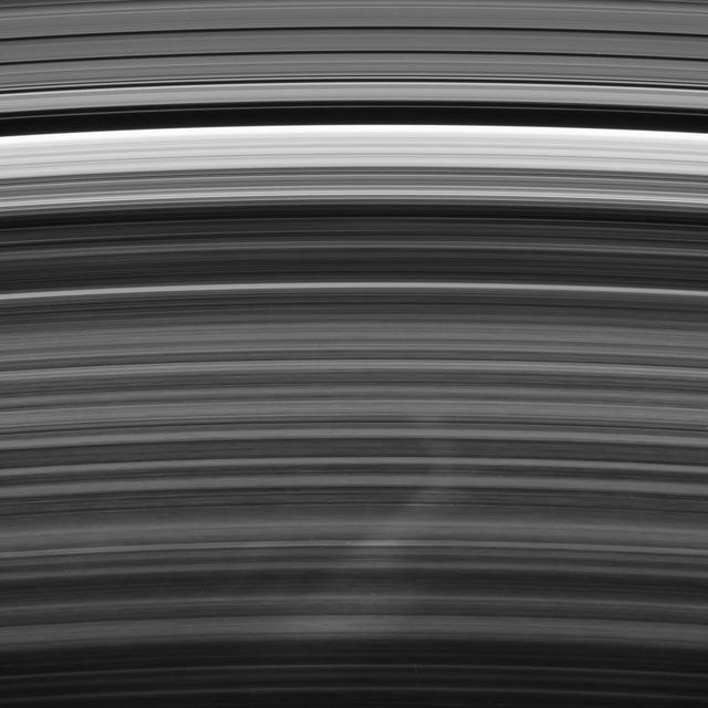
Saturn moon Prometheus casts a long shadow across the A ring in the middle-right side of this image taken shortly before the planet August 2009 equinox by NASA Cassini spacecraft.
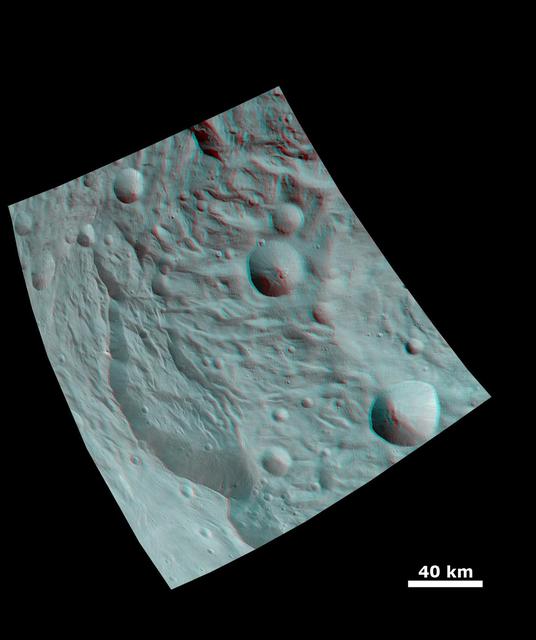
This anaglyph image from NASA Dawn spacecraft shows the topography of asteroid Vesta south polar region. The material at the base of the scarp right side is probably due to landsliding.
These images from NASA Dawn spacecraft are located in asteroid Vesta Urbinia quadrangle, in Vesta southern hemisphere; many small boulders are visible on the right side of Sossia crater.
This image, taken by NASA Mars Odyssey spacecraft, shows a cratered highland region called Arabia Terra. The center right side of the image shows a branch of the valley network Naktong Vallis cutting into the eastern rim of an unnamed crater.
NASA Curiosity Mars rover as the rover drove over a dune spanning Dingo Gap on Mars. The light-toned dome on the right side of the horizon is part of Mount Sharp.
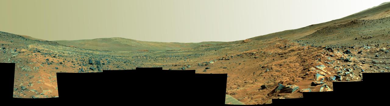
This panorama shows two rock-strewn slopes on the left and right sides of a broad, U-shaped dip in the middle. The sandy surface in front of the rover is reddish brown; individual rocks and more distant features are blue-gray
This image from NASA 2001 Mars Odyssey spacecraft of Daedalia Planum shows the termination or end of a single flow. In this case it is the end of the brighter/rougher flow on the right side of the image.
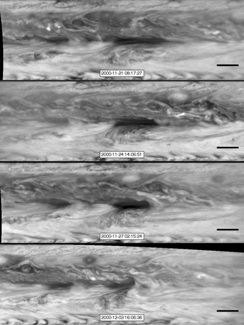
In this series of images from NASA Cassini spacecraft, a dark, rectangular hot spot interacts with a line of vortices that approaches from on the upper-right side. The interaction distorts the shape of the hot spot, leaving it diminished.
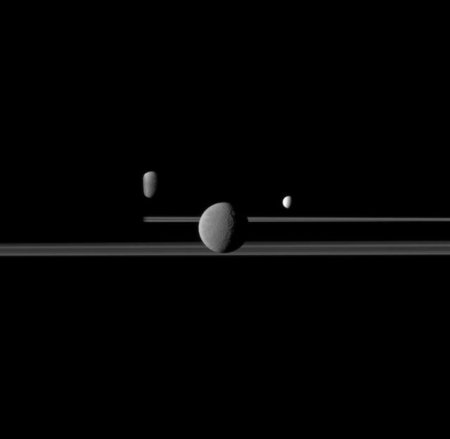
A quintet of Saturn moons come together in this portrait from NASA Cassini spacecraft. Janus is seen on the far left, Pandora orbits near the middle, Enceladus appears above the center, and Rhea and Mimas are seen on the right side.
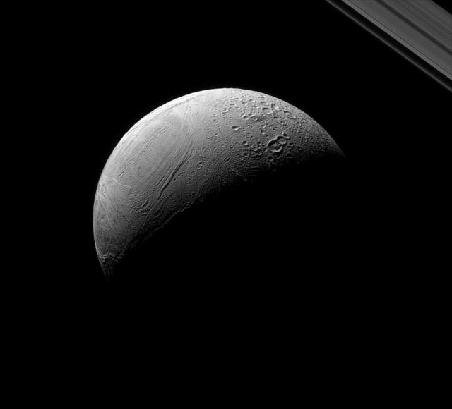
Enceladus dramatically displays the contrast between its older and newer terrain as seen by NASA Cassini spacecraft. This view looks toward the anti-Saturn side of Enceladus. North on Enceladus is up and rotated 36 degrees to the right.
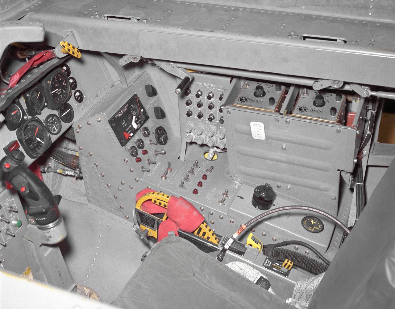
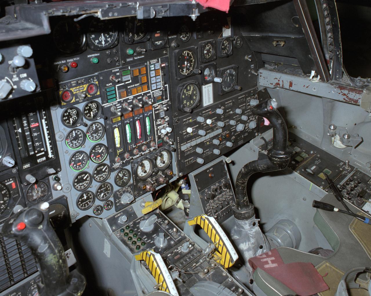
This photo shows the right side cockpit instrumentation panel of the M2-F2 Lifting Body. The success of Dryden's M2-F1 program led to NASA's development and construction of two heavyweight lifting bodies based on studies at NASA's Ames and Langley research centers -- the M2-F2 and the HL-10, both built by the Northrop Corporation. The "M" refers to "manned" and "F" refers to "flight" version. "HL" comes from "horizontal landing" and 10 is for the tenth lifting body model to be investigated by Langley. The first flight of the M2-F2 -- which looked much like the "F1" -- was on July 12, 1966. Milt Thompson was the pilot. By then, the same B-52 used to air launch the famed X-15 rocket research aircraft was modified to also carry the lifting bodies. Thompson was dropped from the B-52's wing pylon mount at an altitude of 45,000 feet on that maiden glide flight. The M2-F2 weighed 4,620 pounds, was 22 feet long, and had a width of about 10 feet. On May 10, 1967, during the sixteenth glide flight leading up to powered flight, a landing accident severely damaged the vehicle and seriously injured the NASA pilot, Bruce Peterson. NASA pilots and researchers realized the M2-F2 had lateral control problems, even though it had a stability augmentation control system. When the M2-F2 was rebuilt at Dryden and redesignated the M2-F3, it was modified with an additional third vertical fin -- centered between the tip fins -- to improve control characteristics. The M2-F2/F3 was the first of the heavy-weight, entry-configuration lifting bodies. Its successful development as a research test vehicle answered many of the generic questions about these vehicles. NASA donated the M2-F3 vehicle to the Smithsonian Institute in December 1973. It is currently hanging in the Air and Space Museum along with the X-15 aircraft number 1, which was its hangar partner at Dryden from 1965 to 1969.
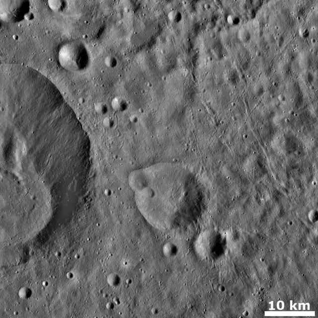
This view from NASA's Dawn spacecraft shows different types of terrain located side by side on Ceres: a smooth terrain at right with numerous small impact craters, and a less-cratered, hummocky terrain at left. A huge crater chain crosses the scene diagonally from upper left to lower right. The smooth terrain, which is in the western part of Yalode impact basin, is interrupted by a set of roughly parallel furrows and ridges at upper right. These linear features are perpendicular to another set of smaller, fainter linear markings, which appear just below them. An impact into the hummocky terrain formed a crater, seen at left, 14 miles (22 kilometers) in diameter with a central peak. A great deal of material has slumped down the walls of the crater -- a phenomenon called mass wasting. The crater's impact ejecta forms a smooth blanket around its rim, which takes on a streaky texture leading away from the crater toward lower right. The image was taken during in Dawn's High Altitude Mapping Orbit (HAMO) phase from an altitude of 911 miles (1,466 kilometers) on Oct. 6, 2015. Image resolution is 394 feet (120 meters) per pixel. The image is centered at 37 degrees south latitude, 279 degrees east longitude. http://photojournal.jpl.nasa.gov/catalog/PIA20133
These side-by-side images were taken by the Pan Camera (Pancam) on NASA's Opportunity rover. They're actually the same image; the left version is how the image originally came down, due to data dropouts. The right shows the same image after processing all the data. The image is from the 4,493rd Martian day, or sol, of the mission. https://photojournal.jpl.nasa.gov/catalog/PIA23248
View of the right cockpit of the F-111 MAW aircraft. Unlike most fighter aircraft of the time, the F-111 had side-by-side seating. The pilot sat on the left side, and the weapons systems officer on the right. Both had control sticks to fly the aircraft.

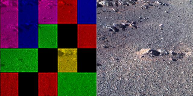
This radar image shows the area west of the Nile River near Cairo, Egypt. The Nile River is the dark band along the right side of the image and it flows approximately due North from the bottom to the right. The boundary between dense urbanization and the desert can be clearly seen between the bright and dark areas in the center of the image. This boundary represents the approximate extent of yearly Nile flooding which played an important part in determining where people lived in ancient Egypt. This land usage pattern persists to this day. The pyramids at Giza appear as three bright triangles aligned with the image top just at the boundary of the urbanized area. They are also shown enlarged in the inset box in the top left of the image. The Great Pyramid of Khufu (Cheops in Greek) is the northern most of the three Giza pyramids. The side-looking radar illuminates the scene from the top, the two sides of the pyramids facing the radar reflect most of the energy back to the antenna and appear radar bright; the two sides away from the radar reflect less energy back and appear dark Two additional pyramids can be seen left of center in the lower portion of the image. The modern development in the desert on the left side of the image is the Sixth of October City, an area of factories and residences started by Anwar Sadat to relieve urban crowding. The image was taken on April 19, 1994 by the Spaceborne Imaging Radar-C/X-Band Synthetic Aperture Radar (SIR-C/X-SAR) aboard the shuttle Endeavour. SIR-C/X-SAR, a joint mission of the German, Italian and the United States space agencies, is part of NASA's Mission to Planet Earth. The image is centered on latitude 29.72 degrees North latitude and 30.83 degrees East longitude. The area shown is approximately 20 kilometers by 30 kilometers. The colors in the image are assigned to different frequencies and polarizations of the radar as follows: red is L-band horizontally transmitted, horizontally received; green is C-band horizontally transmitted, horizontally received; blue is C-band horizontally transmitted, vertically received. http://photojournal.jpl.nasa.gov/catalog/PIA01793
This image of was obtained by NASA's Dawn spacecraft on May 30, 2018 from an altitude of about 420 miles (675 kilometers). Ejecta from Haulani Crater can be seen on the right side of the image. The center of this picture is located at about 2 degrees south in latitude and 6 degrees east in longitude. https://photojournal.jpl.nasa.gov/catalog/PIA22518
Today's VIS image from NASA's 2001 Mars Odyssey is of an unnamed crater in Chryse Planitia. There are several concentric ridges visible on the right side of this image. These features formed at the time of impact and are part of the rim structure of this crater. Numerous gullies dissect the rim and a small dune field is located on the floor of the crater. Orbit Number: 61676 Latitude: 36.5047 Longitude: 329.655 Instrument: VIS Captured: 2015-11-09 04:07 http://photojournal.jpl.nasa.gov/catalog/PIA20233
T&R Endeavour Right Side Tail Cone Buildup
T&R Endeavour Right Side Tail Cone Buildup
T&R Endeavour Right Side Tail Cone Buildup
T&R Endeavour Right Side Tail Cone Buildup
T&R Endeavour Right Side Tail Cone Buildup

iss058e013244 (Feb. 13, 2019) --- The forward end of the International Space Station is pictured showing portions of five modules. From right to left is a portion of the U.S. Destiny laboratory module linking forward to the Harmony module. Attached to the port side of Harmony (left foreground) is the Kibo laboratory module from the Japan Aerospace Exploration Agency (JAXA) with its logistics module berthed on top. On Harmony's starboard side (center background) is the Columbus laboratory module from ESA (European Space Agency).

jsc2022e004237 (11/8/2021) --- A Preflight image of the Acoustics to Manipulate Fluids investigation, the acoustic tweezer apparatus is installed inside the Microgravity Science Glovebox Engineering Unit. The sample chamber, shown in the upper the right side, is where fluid droplets are injected via a septum located on the right side and manipulated by an ultrasonic transducer located on the left side. Image courtesy of Dr. Robert Lirette.

jsc2024e006088 (1/18/2024) --- Some members from MicroOrbiter-1 team were performing a long range communication test within University Campus with the satellite side, while the Ground Terminal side was on the other side .From left to right : ABBAS Yasir, MOUMNI Fahd...Image Credit: MOUMNI Fahd.
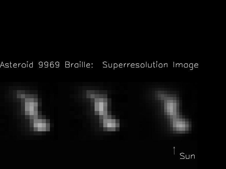
The two images on the left hand side of this composite image frame were taken 914 seconds and 932 seconds after the NASA Deep Space 1 encounter with the asteroid 9969 Braille. The image on the right was created by combining the two images on the left.
This color image of the Moon was taken by NASA's Galileo spacecraft at 9:35 a.m. PST Dec. 9, 1990, at a range of about 350,000 miles. The concentric, circular Orientale basin, is near the center; the nearside is to the right, the far side to the left. http://photojournal.jpl.nasa.gov/catalog/PIA00113
This perspective view shows the city of Bhuj, India, in the foreground near the right side dark gray area. Bhuj and many other towns and cities nearby were almost completely destroyed by the January 26, 2001, earthquake in western India.

This series of images shows simulated views of a darkening Martian sky blotting out the Sun from NASA's Opportunity rover's point of view, with the right side simulating Opportunity's current view in the global dust storm (June 2018). The left starts with a blindingly bright mid-afternoon sky, with the sun appearing bigger because of brightness. The right shows the Sun so obscured by dust it looks like a pinprick. Each frame corresponds to a tau value, or measure of opacity: 1, 3, 5, 7, 9, 11. https://photojournal.jpl.nasa.gov/catalog/PIA22521
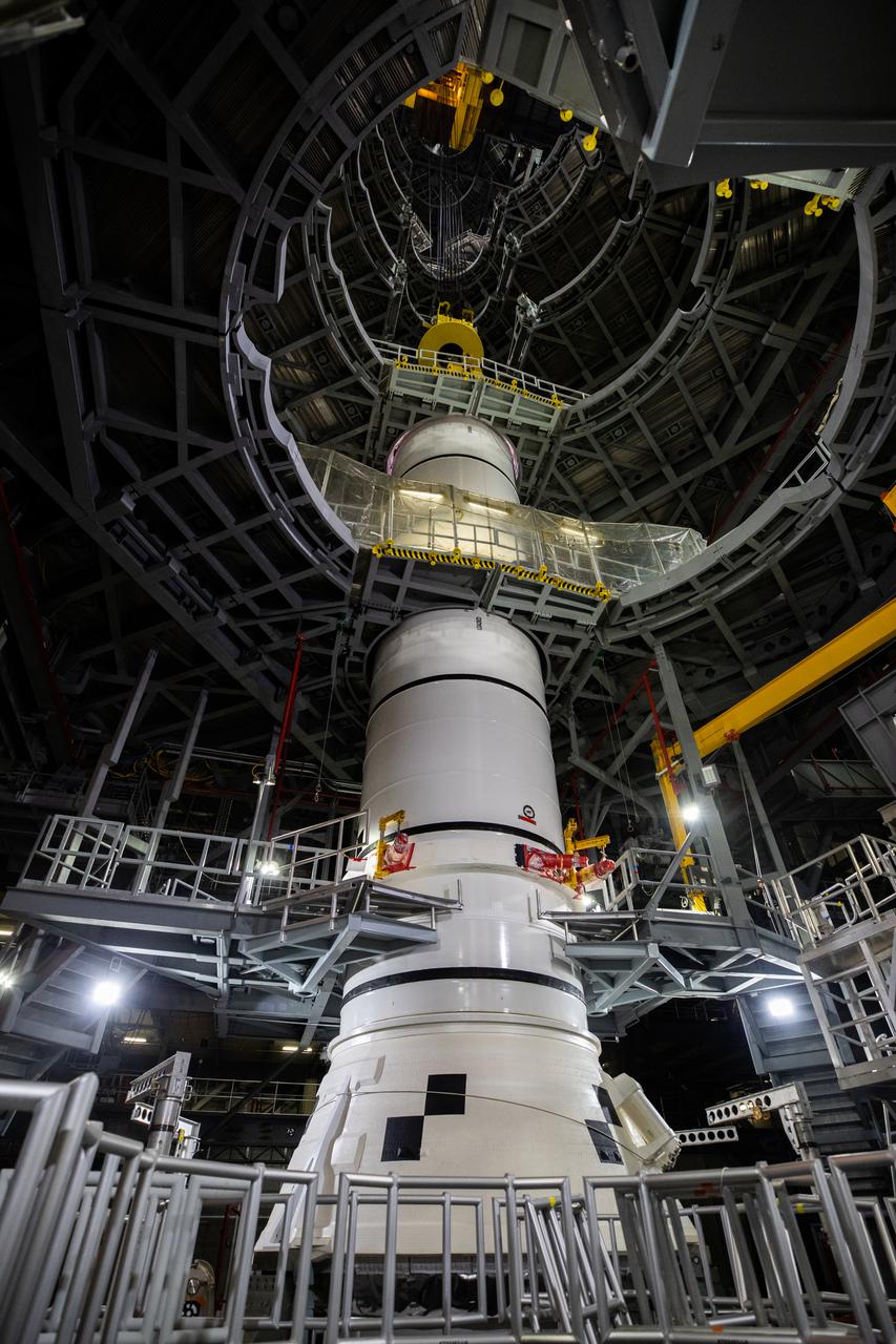
In High Bay 3 of the Vehicle Assembly Building at NASA’s Kennedy Space Center in Florida, the right-hand center aft booster segment for Artemis I is lowered onto the aft booster segment on the mobile launcher for the Space Launch System (SLS) on Jan. 12, 2021. Workers with Exploration Ground Systems and contractor Jacobs teams will stack the twin five-segment boosters on the mobile launcher in High Bay 3 over a number of weeks. When the core stage arrives, it will join the boosters on the mobile launcher, followed by the interim cryogenic propulsion stage and Orion spacecraft. Manufactured by Northrop Grumman in Utah, the twin boosters provide more than 75 percent of the total SLS thrust at launch. The SLS is managed by Marshall Space Flight Center in Huntsville, Alabama. Under the Artemis program, NASA will land the first woman and the next man on the Moon by 2024. The first in a series of increasingly complex missions, Artemis I will test the Orion spacecraft and SLS as an integrated system ahead of crewed flights to the Moon.
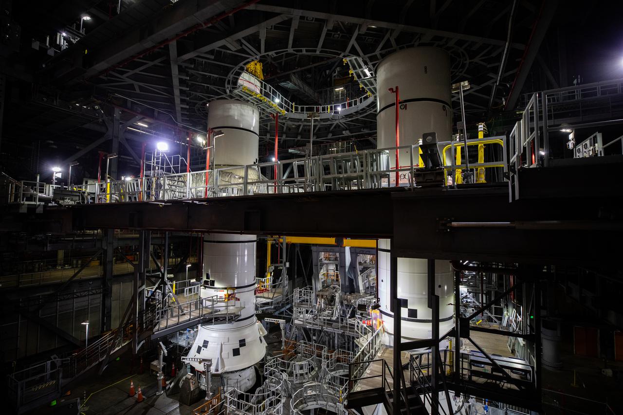
In High Bay 3 of the Vehicle Assembly Building at NASA’s Kennedy Space Center in Florida, the right-hand and left-hand center aft booster segments for Artemis I have been stacked onto the left and right aft booster segments on the mobile launcher for the Space Launch System (SLS) on Jan. 12, 2021. Workers with Exploration Ground Systems and contractor Jacobs teams will stack the twin five-segment boosters on the mobile launcher in High Bay 3 over a number of weeks. When the core stage arrives, it will join the boosters on the mobile launcher, followed by the interim cryogenic propulsion stage and Orion spacecraft. Manufactured by Northrop Grumman in Utah, the twin boosters provide more than 75 percent of the total SLS thrust at launch. The SLS is managed by Marshall Space Flight Center in Huntsville, Alabama. Under the Artemis program, NASA will land the first woman and the next man on the Moon by 2024. The first in a series of increasingly complex missions, Artemis I will test the Orion spacecraft and SLS as an integrated system ahead of crewed flights to the Moon.
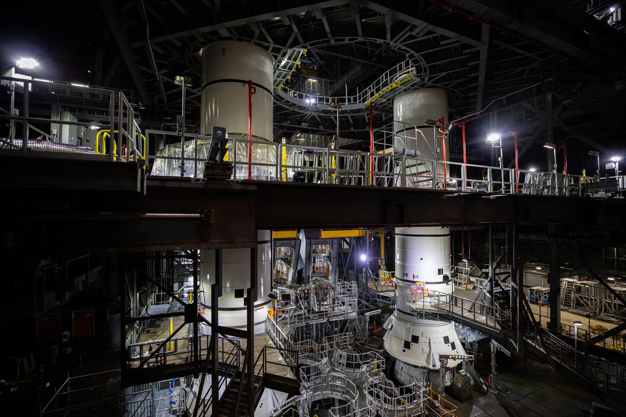
In High Bay 3 of the Vehicle Assembly Building at NASA’s Kennedy Space Center in Florida, the right-hand and left-hand center aft booster segments for Artemis I have been stacked onto the left and right aft booster segments on the mobile launcher for the Space Launch System (SLS) on Jan. 12, 2021. Workers with Exploration Ground Systems and contractor Jacobs teams will stack the twin five-segment boosters on the mobile launcher in High Bay 3 over a number of weeks. When the core stage arrives, it will join the boosters on the mobile launcher, followed by the interim cryogenic propulsion stage and Orion spacecraft. Manufactured by Northrop Grumman in Utah, the twin boosters provide more than 75 percent of the total SLS thrust at launch. The SLS is managed by Marshall Space Flight Center in Huntsville, Alabama. Under the Artemis program, NASA will land the first woman and the next man on the Moon by 2024. The first in a series of increasingly complex missions, Artemis I will test the Orion spacecraft and SLS as an integrated system ahead of crewed flights to the Moon.
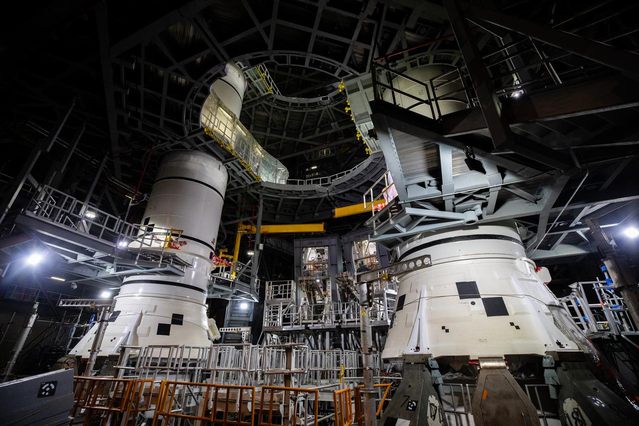
In High Bay 3 of the Vehicle Assembly Building at NASA’s Kennedy Space Center in Florida, the right-hand center aft booster segment for Artemis I is lowered onto the aft booster segment on the mobile launcher for the Space Launch System (SLS) on Jan. 12, 2021. Also in view at left, is the left-hand booster stack. Workers with Exploration Ground Systems and contractor Jacobs teams will stack the twin five-segment boosters on the mobile launcher in High Bay 3 over a number of weeks. When the core stage arrives, it will join the boosters on the mobile launcher, followed by the interim cryogenic propulsion stage and Orion spacecraft. Manufactured by Northrop Grumman in Utah, the twin boosters provide more than 75 percent of the total SLS thrust at launch. The SLS is managed by Marshall Space Flight Center in Huntsville, Alabama. Under the Artemis program, NASA will land the first woman and the next man on the Moon by 2024. The first in a series of increasingly complex missions, Artemis I will test the Orion spacecraft and SLS as an integrated system ahead of crewed flights to the Moon.

In High Bay 3 of the Vehicle Assembly Building at NASA’s Kennedy Space Center in Florida, the right-hand center aft booster segment for Artemis I is stacked on the mobile launcher for the Space Launch System (SLS) on Jan. 7, 2021. Also in view is the left-hand booster stack. Workers with Exploration Ground Systems and contractor Jacobs teams will stack the twin five-segment boosters on the mobile launcher in High Bay 3 over a number of weeks. When the core stage arrives, it will join the boosters on the mobile launcher, followed by the interim cryogenic propulsion stage and Orion spacecraft. Manufactured by Northrop Grumman in Utah, the twin boosters provide more than 75 percent of the total SLS thrust at launch. The SLS is managed by Marshall Space Flight Center in Huntsville, Alabama. Under the Artemis program, NASA will land the first woman and the next man on the Moon by 2024. The first in a series of increasingly complex missions, Artemis I will test the Orion spacecraft and SLS as an integrated system ahead of crewed flights to the Moon.
Sintana Crater is seen on the left side of this image of Ceres from NASA's Dawn spacercraft. The crater's central peak casts a shadow over its western flank. At lower right, the rim of Darzamat peeks into view. Dawn took this image on Oct. 19 from its second extended-mission science orbit (XMO2), at a distance of about 920 miles (1,480 kilometers) above the surface. The image resolution is about 460 feet (140 meters) per pixel. http://photojournal.jpl.nasa.gov/catalog/PIA21234
This image, taken by NASA's Dawn spacecraft, shows high southern latitudes on Ceres from an altitude of 2,700 miles (4,400 kilometers). The image, with a resolution of 1,400 feet (410 meters) per pixel, was taken on June 25, 2015. Zadeni crater, measuring about 80 miles (130 kilometers) across, is on the right side of the image. http://photojournal.jpl.nasa.gov/catalog/PIA19634
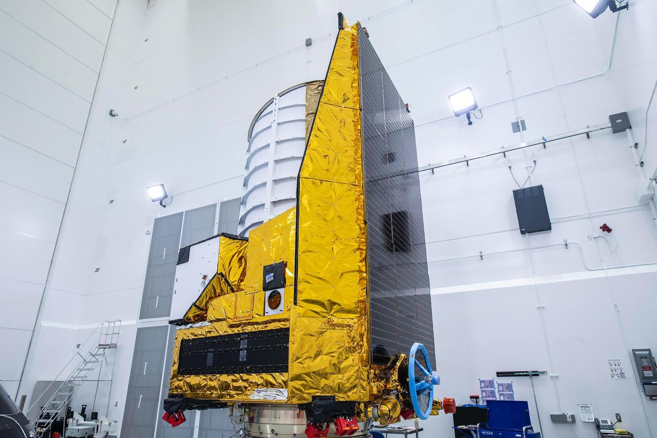
The ESA (European Space Agency) Euclid telescope, with contributions from NASA, is shown here on Friday 23 June, being secured to the adaptor of a SpaceX Falcon 9 rocket before launch. Black solar panels line the right side of the spacecraft. The telescope will view the cosmos through the top of the white cylinder that sits above the spacecraft's instruments. https://photojournal.jpl.nasa.gov/catalog/PIA25783
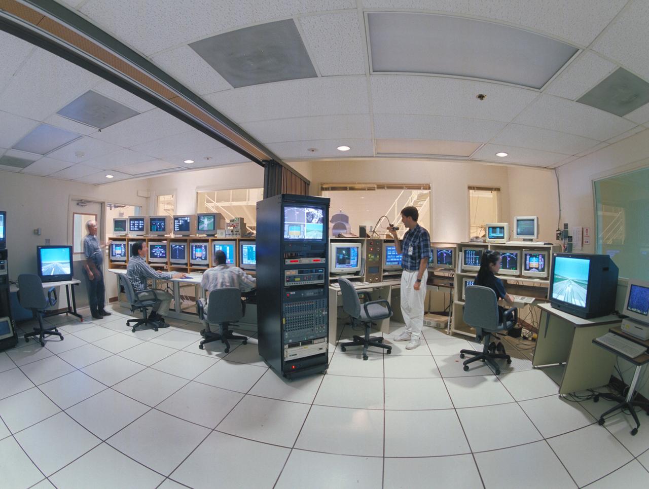
N-257 CVSRF: control rooms for 747 and ACSF cabs - LEFT SIDE; EOS - ACFS (Advanced Cab Flight Simulator) w. (l-r) Victor Loesche, Hector Reyes & Eric Jacobs and RIGHT SIDE; EOS - 747 Cab with (l-r) David Brown and Cindy Nguyen
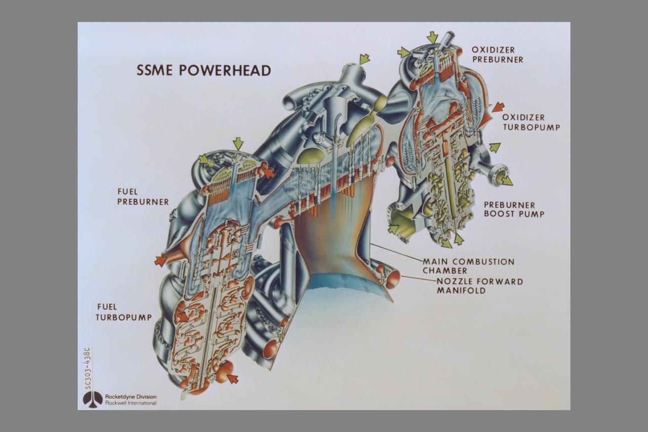
cutaway Rockwell International Space Shuttle Main Engines: Powerhead (Left side - fuel preburner, fuel trubopump - Center - Main Combustion Chamber, nozzle forward manifold - Right side - oxidizer preburner, oxidizer turbopump, preburner boost pump)

A close up deploy view of the Hubble Space Telescope on the end of the space shuttle remote manipulator system (RMS) with Eastern Cuba, (20.0N, 74.0W) seen on the left side of the telescope and northern Haiti seen on the right side of the telescope. The light colored blue feature in the water north of Haiti is the shallow waters of the Caicos Bank.

ISS027-E-027019 (12 May 2011) --- Parts of two states highly impacted by recent flooding of the Mississippi River, are pictured in this International Space Station image featuring an area east of Blytheville, Ark., off the right side of the image. Center point coordinates are located at 35.8 degrees north latitude and 89.7 degrees west longitude The areas of Ruckers Place, Tenn. and Tomato, Ark. are surrounded by water, while Barfield, Ark. is still dry behind the levee on the right side of the image. North is toward the bottom of the photo.

ISS01-E-5078 (December 2000) --- A northwesterly-looking view from over the Gulf of Mexico reveals much of Galveston and Harris Counties, as photographed with a digital still camera from the Earth-orbiting International Space Station (ISS). Galveston Island and Galveston Bay take up most of the right side of the frame, with parts of southern Harris County and even part of north Harris County, including Lake Houston, are visible on the left side of the frame. The Texas City Dike is in the upper right quadrant of the image.
art002e009057 (April 4, 2026) - A view of the nearside of the Moon, the side we always see from Earth. Some of the far side is visible, as well, on the left edge, just beyond the black patch that is Orientale basin, a nearly 600-mile-wide crater that straddles the Moon’s near and far sides and is partly visible from Earth. The dark areas in the center and right side of the disk are ancient lava flows, which are unique to the near side of the Moon. The white dot at the bottom of the disk, with white rays shooting out from it, is Tycho crater, one of the younger craters on the Moon at 108 million years old.

Juno's Radiation Monitoring Investigation used the Stellar Reference Unit (SRU) star camera to collect this high-resolution image of the dark side of Jupiter during Perijove 11 on Feb. 7, 2018. The clouds are illuminated by moonlight from Jupiter's moon Io and the two bright spots on the right side of the image are flashes of Jovian lightning. Juno was only 41,000 miles (66,000 kilometers) from the cloud tops when this SRU image was collected. The left side of the composite image shows a 3-dimensional visualization of Jupiter's Northern hemisphere with its northern aurora included. To the right of the aurora and solar terminator line, is a box illustrating the position of the SRU field of view at the time the image was taken. Further to the right is an exploded view of the SRU image. https://photojournal.jpl.nasa.gov/catalog/PIA22965
art002e009280 (April 6, 2026) – Earthrise captured through the Orion spacecraft window at 7:22 p.m. ET during the Artemis II crew’s flyby of the Moon’s far side. Earth appears as a delicate crescent, with only its right edge illuminated. The planet’s soft blue hue and scattered white cloud systems stand out on the right against the blackness of space, while the left side fades into night. Taken with a 400 mm lens, the image, Earthrise, reveals a striking alignment of Earth and Moon. In the foreground on the right, a portion of the Moon in night is barely visible save for its edge, which stands out in stark contrast against the illuminated side of Earth on the left. Zooming in along the Moon’s edge reveals rugged terrain silhouetted against the bright crescent Earth. This photo was rotated 90 degrees clockwise from the original for standard viewing orientation.
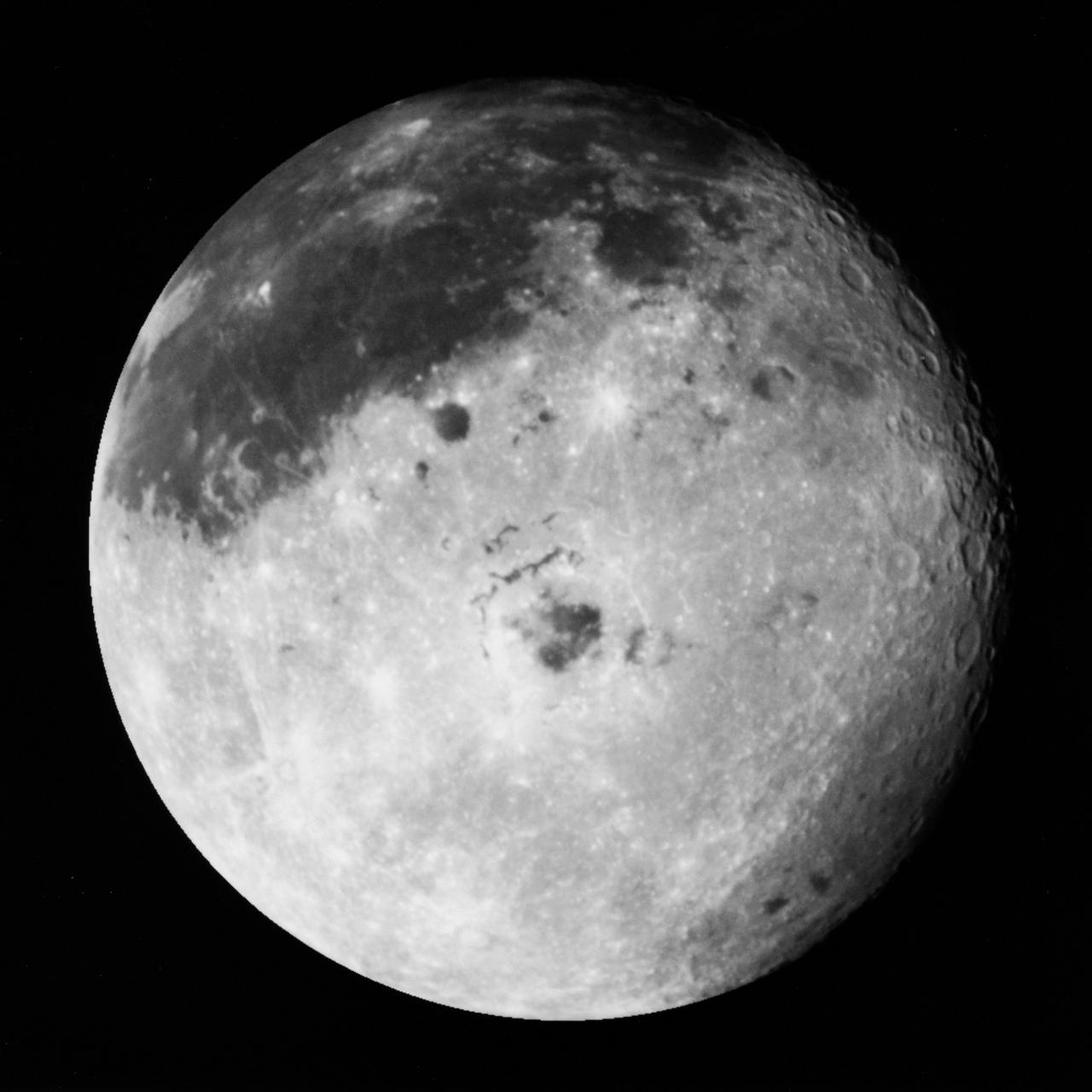
S90-55753 (9 Dec. 1990) --- This color image of the Moon was taken by the Galileo spacecraft at 9:25 a.m. (PST) December 9, 1990, at a range of about 350,000 miles. The color composite uses monochrome images taken through violet, red, and near infrared filters. The concentric, circular Orientale Basin, 600 miles across, is near the center; the near side is to the right, the far side to the left. At the upper right is the large, dark Oceanus Procellarum; below it is the smaller Mare Humorum. These, like the small dark Mare Orientale in the center of the basin, formed over 3 billion years ago as basaltic lava flows. At the lower left, among the southern cratered highlands of the far side, is the South-Pole-Aitken Basin, similar to Orientale but twice as great in diameter and much older and more degraded by crating and weathering. The cratered highlights of the near and far sides and the Maria are covered with scattered bright, young ray-craters.

STS035-49-029 (2-10 Dec 1990) --- Posing on the middeck of Columbia, Orbiter Vehicle (OV) 102, are Mission Specialist (MS) Jeffrey A. Hoffman (mustache) and MS Robert A. R. Parker. Determining who is right side up is complicated by the microgravity of space. Hoffman's head is at the middeck floor and his feet are at the ceiling. The two crewmembers are in front of OV-102's port side with the waste collection system (WCS) contingency unit, side hatch, and galley visible behind them.
View of the left cockpit and pilot's seat of the F-111 MAW aircraft. Unlike most fighter aircraft of the time, the F-111 had side-by-side seating. The pilot sat on the left side, and the weapons systems officer on the right. Both had control sticks to fly the aircraft. The two yellow and black striped handles would be used in an emergency to eject the entire F-111 cockpit. The F-111 also did not have ejection seats, but used a capsule.
iss073e0886792 (Oct. 1, 2025) --- The Mexico–United States border separates Baja California (left) on the Mexican side from California (right) on the U.S. side in this photograph from the International Space Station as it orbited 261 miles above. This region is part of the Sonoran Desert, with the Algodones Dunes prominently visible on the U.S. side. Near upper left, is the Mexican city of San Luis Río Colorado with a population of about 177,000.

A series of active regions stretched along the right side of the sun exhibited a wide variety of loops cascading above them (Sept. 12-14, 2016). The active region near the center has tightly coiled loops, while the region rotating over the right edge has some elongated and some very stretched loops above it. The loops are actually charged particles spiraling along magnetic field lines, observed here in a wavelength of extreme ultraviolet light. Near the middle of the video the Earth quickly passes in front of a portion of the sun as viewed by SDO. http://photojournal.jpl.nasa.gov/catalog/PIA16997

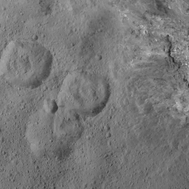
This image from NASA's Mars Reconnaissance Orbiter (MRO) shows two small impact craters located in Meridiani Planum. This is an example of the geologic principle of superposition: figuring out what happened first by looking at how features interact with each other. We can see that one of the craters must have hit the surface after the other was already there, but which came first? We can see that the ejecta blankets look rougher on the right side of the image than they do on the left. This could mean that the right side ejecta is newer, and has not been exposed to the wind as much as the left side has. Zooming in, we see small boulders on the floor and walls of the left-side crater, and they even seem to match the rough material in the ejecta on the right. With these clues, we can hypothesize that the crater on the left was here first. After some time another asteroid hit, formed the crater on the right, which threw material onto the floor of the left, where it remains to this day. https://photojournal.jpl.nasa.gov/catalog/PIA22454

art002e012702 (April 6, 2026) – Poynting crater and Keeler crater are visible side by side in the lower right portion of this image of the Moon’s far side highlands. Poynting, positioned above, is a large impact crater with a well-defined rim and relatively smooth interior, indicative of material that has settled following the initial impact. Just below it, Keeler crater appears slightly smaller, with a sharply outlined rim and a more textured interior shaped by subsequent impacts and ejecta. Both features lie within the densely cratered far side highlands, preserving a record of ancient impacts that have shaped the lunar surface over billions of years.
3/4 front right side only with Tim Wills on right and Charles Greco, mechanic. Large flaps on Variable height struts. XC-142 was a tri-service tiltwing experimental aircraft designed to investigate the operational suitability of vertical/short takeoff and landing (V/STOL) transports.

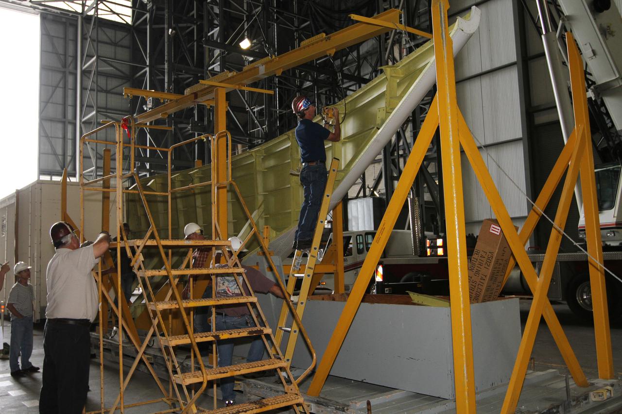
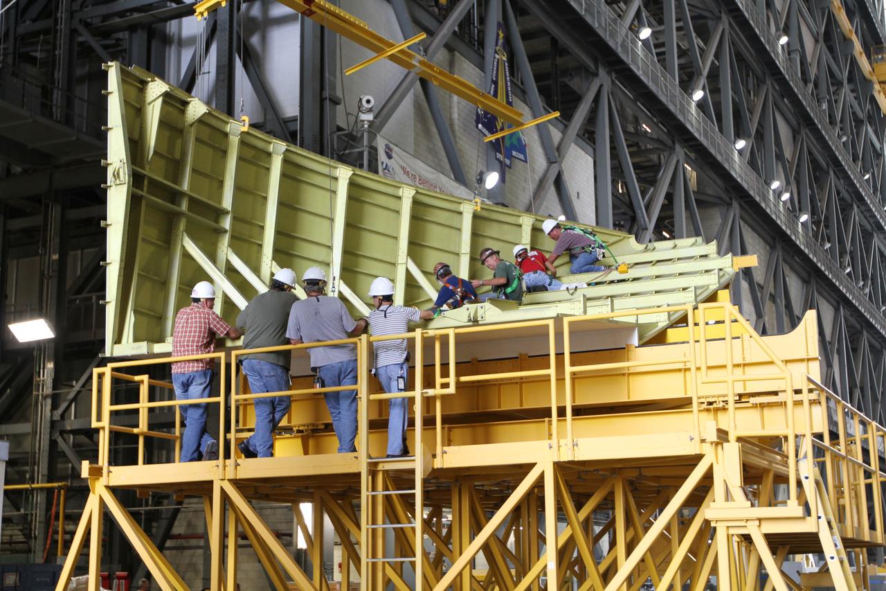
Event: SEG 410 Main Wing A Lockheed Martin technician works on the installation of wiring on the trailing edge structure of the right side of the X-59’s wing. The aircraft, under construction at Lockheed Martin Skunk Works in Palmdale, California, will demonstrate the ability to fly supersonic while reducing the loud sonic boom to a quiet sonic thump.
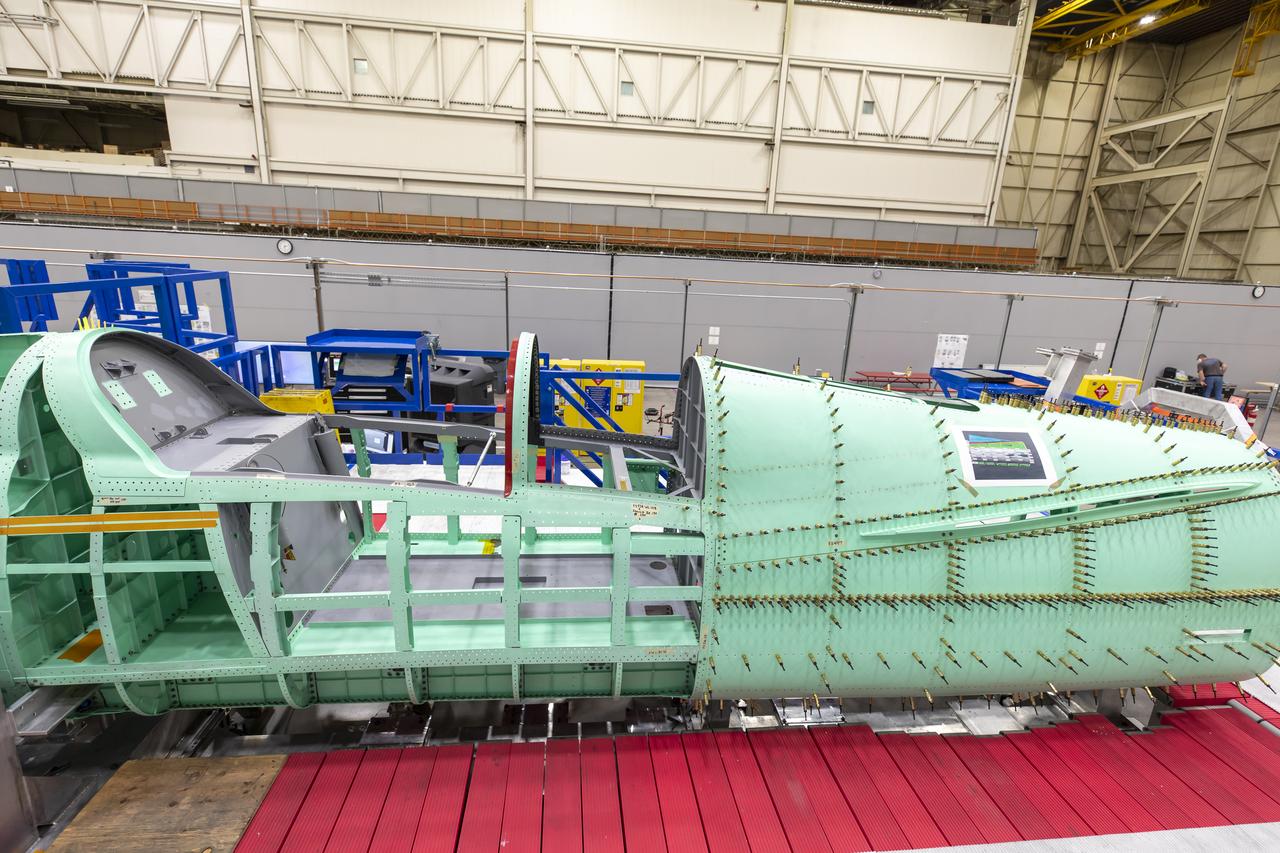
Event: SEG 210 Forebody A right side view of where the team is preparing the X-59 structure for installation of the forward fuselage, which contains the cockpit. The aircraft, under construction at Lockheed Martin Skunk Works in Palmdale, California, will fly to demonstrate the ability to fly supersonic while reducing the loud sonic boom to a quiet sonic thump.
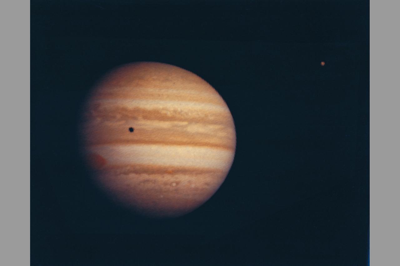
Photograph by Pioneer 10 Jupiter at a range of 2584000km (ref: image number sequence A-51 (before) during the 4 days on either side of closest approach) moon seen on upper right on image.

ISS030-E-064161 (2 Feb. 2012) --- Parts of a number of European nations appear in this nighttime image photographed from the International Space Station. The scene, captured by one of the Expedition 30 crew members, shows the British Isles (left, partially obstructed by one of the space station's solar array panels) with London just right of bottom center; the English Channel, which is dark; Paris (lower right corner); and the Netherlands (right side). The greenish airglow is fairly uniform and minor until it transitions to daybreak on the right.