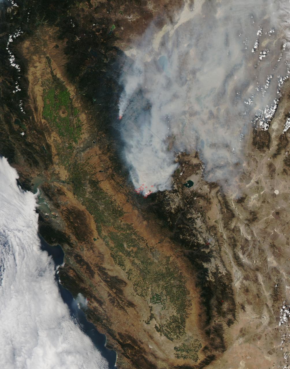
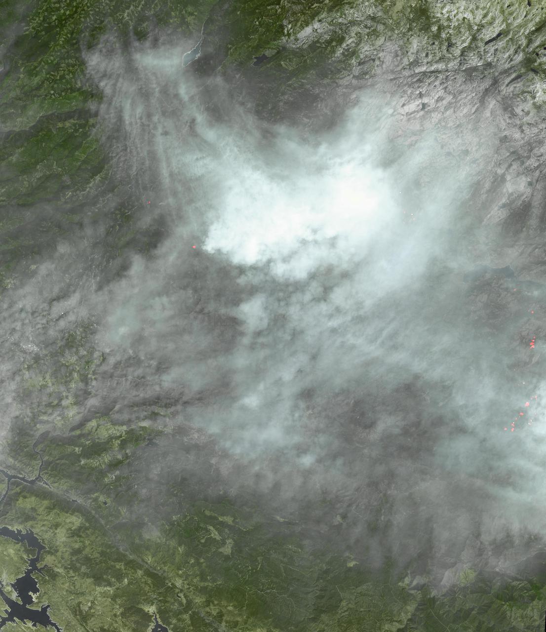
On August 23, 2013, the Moderate Resolution Imaging Spectroradiometer (MODIS) on NASA’s Aqua satellite acquired this image of the drought-fueled Rim fire burning in central California, near Yosemite National Park. Red outlines indicate hot spots where MODIS detected unusually warm surface temperatures associated with fires. Winds blew a thick smoke plume toward the northeast. A smaller fire—American fire—burned to the north. The lower image is a photograph that shows the fire burning at night on August 21. Started on August 17, 2013, the fast-moving fire had already charred more than 100,000 acres (40,000 hectares) by August 23, despite the efforts of more than 2,000 firefighters. Hundreds of people were forced to evacuate their homes, and roads in the area were closed. As of August 23, no structures had been reported destroyed, but the fire threatened the towns of Groveland and Pine Mountain Lake. By late August, wildfires had burned 3.4 million acres in the United States, making 2013 somewhat less active than other recent years. Over the last decade, fires charred 5.7 million acres on average by August 22, according to statistics published the National Interagency Fire Center. NASA image by Jeff Schmaltz, LANCE/EOSDIS Rapid Response. Caption by Adam Voiland. Instrument: Aqua - MODIS Credit: <b><a href="http://www.earthobservatory.nasa.gov/" rel="nofollow"> NASA Earth Observatory</a></b> <b><a href="http://www.nasa.gov/audience/formedia/features/MP_Photo_Guidelines.html" rel="nofollow">NASA image use policy.</a></b> <b><a href="http://www.nasa.gov/centers/goddard/home/index.html" rel="nofollow">NASA Goddard Space Flight Center</a></b> enables NASA’s mission through four scientific endeavors: Earth Science, Heliophysics, Solar System Exploration, and Astrophysics. Goddard plays a leading role in NASA’s accomplishments by contributing compelling scientific knowledge to advance the Agency’s mission. <b>Follow us on <a href="http://twitter.com/NASA_GoddardPix" rel="nofollow">Twitter</a></b> <b>Like us on <a href="http://www.facebook.com/pages/Greenbelt-MD/NASA-Goddard/395013845897?ref=tsd" rel="nofollow">Facebook</a></b> <b>Find us on <a href="http://instagram.com/nasagoddard?vm=grid" rel="nofollow">Instagram</a></b>
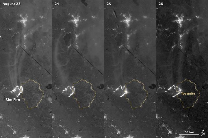
The winter of 2013 was among the driest on record for California, setting the stage for an active fire season. By August 26, the Rim Fire had made its way into the record books. At just 15 percent contained, the fire is now the 13th largest in California since records began in 1932. Apart from being large, the fire is also threatening one of the United States’ greatest natural treasures: Yosemite National Park. The Visible Infrared Imaging Radiometer Suite (VIIRS) on the Suomi NPP satellite tracked the growth of the fire between August 23 and August 26 in this series of nighttime images. The VIIRS day-night band is extremely sensitive to low light, making it possible to see the fire front from space. The brightest, most intense parts of the fire glow white, exceeding the brightness of the lights of Reno, Nevada to the north. Pale gray smoke streams north away from the fire throughout the sequence. The perimeter of the fire grows from day to day along different fronts, depending on winds and fire fighting efforts. On August 24, fire fighters focused their efforts on containing the western edge of the fire to prevent it from burning into Tuolumne City and the populated Highway 108 corridor. They also fought the eastern edge of the fire to protect Yosemite National Park. These efforts are evident in the image: Between August 23 and 24, the eastern edge of the fire held steady, and the western edge receded. The fire grew in the southeast. On the morning of August 25 fire managers reported that the fire was growing in the north and east. In the image, the most intense activity is just inside Yosemite National Park. Fire fighters reported that the Rim Fire continued to be extremely active on its eastern front on the morning of August 26, and this activity is visible in the image. By 8:00 a.m., the fire had burned 149,780 acres. The fire forced firefighters in Yosemite National Park to take measures to protect the Merced and Tuolumne Groves of Giant Sequoias, but the National Park Service reported that the trees were not in imminent danger. While parts of the park are closed, webcams show that most of the park has not been impacted. The Rim Fire started on the afternoon of August 17. It has destroyed 23 structures and threatened 4,500 other buildings. Its cause is under investigation. More details: <a href="http://1.usa.gov/18ilEAA" rel="nofollow">1.usa.gov/18ilEAA</a> NASA Earth Observatory image by Jesse Allen and Robert Simmon, using VIIRS Day Night Band data. Caption by Holli Riebeek. Instrument: Suomi NPP - VIIRS <b><a href="http://www.nasa.gov/audience/formedia/features/MP_Photo_Guidelines.html" rel="nofollow">NASA image use policy.</a></b> <b><a href="http://www.nasa.gov/centers/goddard/home/index.html" rel="nofollow">NASA Goddard Space Flight Center</a></b> enables NASA’s mission through four scientific endeavors: Earth Science, Heliophysics, Solar System Exploration, and Astrophysics. Goddard plays a leading role in NASA’s accomplishments by contributing compelling scientific knowledge to advance the Agency’s mission. <b>Follow us on <a href="http://twitter.com/NASA_GoddardPix" rel="nofollow">Twitter</a></b> <b>Like us on <a href="http://www.facebook.com/pages/Greenbelt-MD/NASA-Goddard/395013845897?ref=tsd" rel="nofollow">Facebook</a></b> <b>Find us on <a href="http://instagram.com/nasagoddard?vm=grid" rel="nofollow">Instagram</a></b>
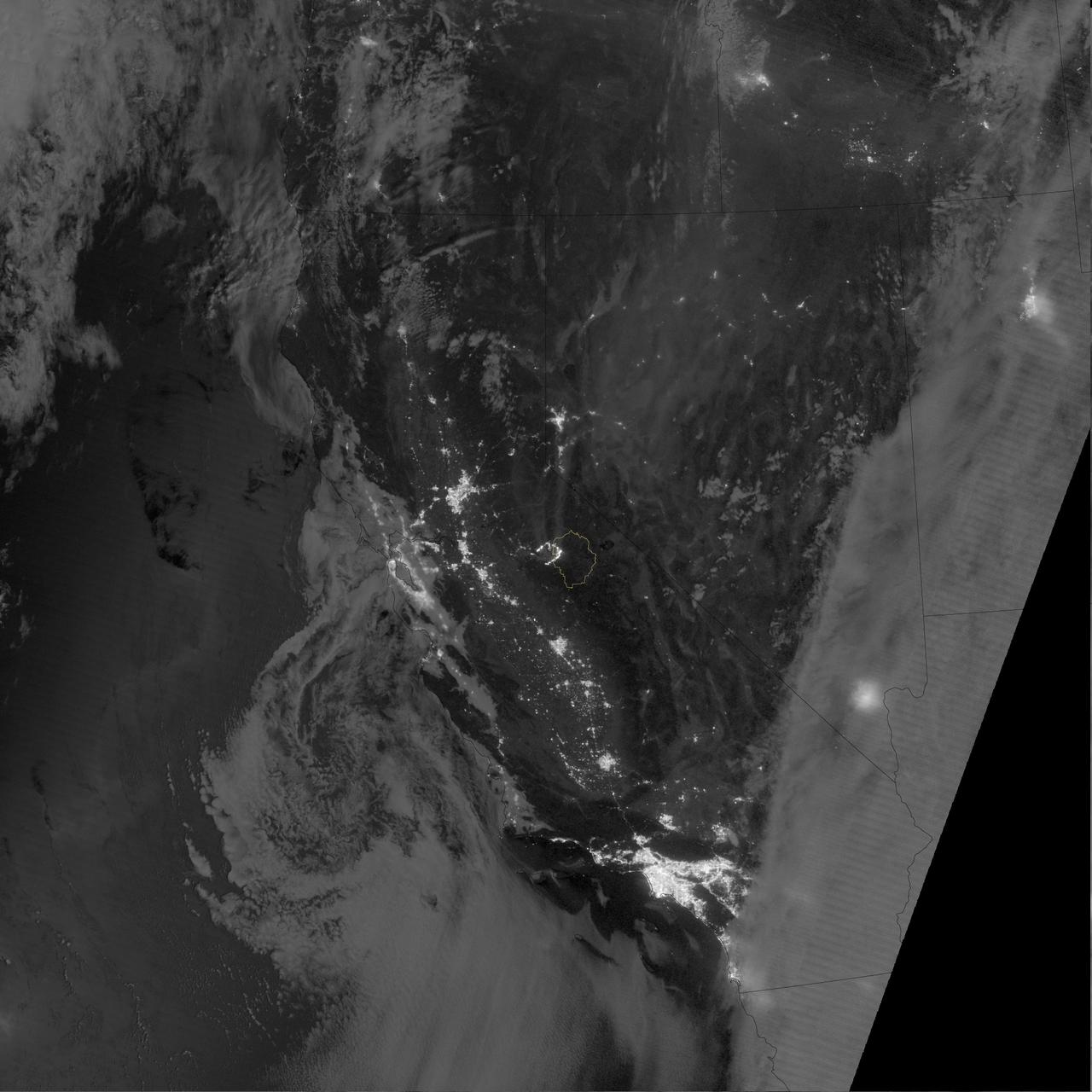
The winter of 2013 was among the driest on record for California, setting the stage for an active fire season. By August 26, the Rim Fire had made its way into the record books. At just 15 percent contained, the fire is now the 13th largest in California since records began in 1932. Apart from being large, the fire is also threatening one of the United States’ greatest natural treasures: Yosemite National Park. The Visible Infrared Imaging Radiometer Suite (VIIRS) on the Suomi NPP satellite tracked the growth of the fire between August 23 and August 26 in a series of nighttime images. The VIIRS day-night band is extremely sensitive to low light, making it possible to see the fire front from space. The brightest, most intense parts of the fire glow white, exceeding the brightness of the lights of Reno, Nevada to the north. Pale gray smoke streams north away from the fire throughout the sequence. The perimeter of the fire grows from day to day along different fronts, depending on winds and fire fighting efforts. On August 24, fire fighters focused their efforts on containing the western edge of the fire to prevent it from burning into Tuolumne City and the populated Highway 108 corridor. They also fought the eastern edge of the fire to protect Yosemite National Park. These efforts are evident in the image: Between August 23 and 24, the eastern edge of the fire held steady, and the western edge receded. The fire grew in the southeast. On the morning of August 25 fire managers reported that the fire was growing in the north and east. In the image, the most intense activity is just inside Yosemite National Park. Fire fighters reported that the Rim Fire continued to be extremely active on its eastern front on the morning of August 26, and this activity is visible in the image. By 8:00 a.m., the fire had burned 149,780 acres. The fire forced firefighters in Yosemite National Park to take measures to protect the Merced and Tuolumne Groves of Giant Sequoias, but the National Park Service reported that the trees were not in imminent danger. While parts of the park are closed, webcams show that most of the park has not been impacted. The Rim Fire started on the afternoon of August 17. It has destroyed 23 structures and threatened 4,500 other buildings. Its cause is under investigation. More details: <a href="http://1.usa.gov/18ilEAA" rel="nofollow">1.usa.gov/18ilEAA</a> NASA Earth Observatory image by Jesse Allen and Robert Simmon, using VIIRS Day Night Band data. Caption by Holli Riebeek. Instrument: Suomi NPP - VIIRS <b><a href="http://www.nasa.gov/audience/formedia/features/MP_Photo_Guidelines.html" rel="nofollow">NASA image use policy.</a></b> <b><a href="http://www.nasa.gov/centers/goddard/home/index.html" rel="nofollow">NASA Goddard Space Flight Center</a></b> enables NASA’s mission through four scientific endeavors: Earth Science, Heliophysics, Solar System Exploration, and Astrophysics. Goddard plays a leading role in NASA’s accomplishments by contributing compelling scientific knowledge to advance the Agency’s mission. <b>Follow us on <a href="http://twitter.com/NASA_GoddardPix" rel="nofollow">Twitter</a></b> <b>Like us on <a href="http://www.facebook.com/pages/Greenbelt-MD/NASA-Goddard/395013845897?ref=tsd" rel="nofollow">Facebook</a></b> <b>Find us on <a href="http://instagram.com/nasagoddard?vm=grid" rel="nofollow">Instagram</a></b>
This image from the MISR instrument onboard NASA Terra spacecraft shows a 121-by-165-mile 194-by-266 kilometer portion of California Rim fire where the smoke is the thickest.
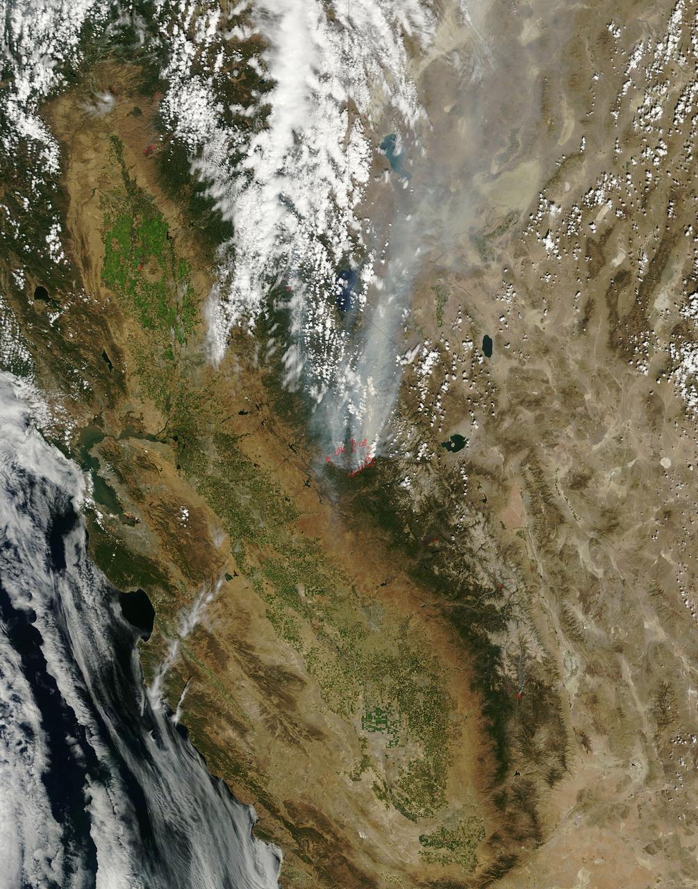
This image, acquired by NASA Terra spacecraft, shows the Rim Fire in and around Yosemite National Park in California after it was 80 percent contained.
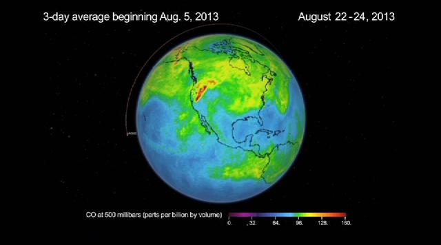
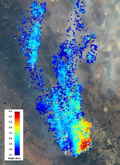
This frame from a movie was produced with data from NASA Aqua spacecraft showing the spread of carbon monoxide pollution across North America from fires in the Western U.S., including the Beaver Creek Fire in Idaho and the Rim Fire in California.
This visible image of California Rim Fire was acquired Aug. 23, 2013 by the Multi-angle Imaging SpectroRadiometer MISR instrument on NASA Terra spacecraft, showing extensive, brownish smoke.
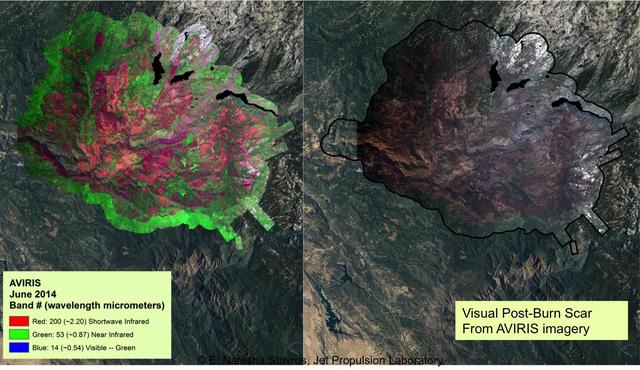
At left, a NASA AVIRIS map shows the spectral signature of the 2013 Rim fire in and near Yosemite National Park, California, the third largest in the state's history, burning more than 250,000 acres. Almost two years later, forest restoration efforts are still ongoing. Charred wood has a strong signal in the wavelengths shown here in red, so areas that are predominantly red in the image were heavily burned. The wavelengths of green, visible light (the color of vegetation) appear on this map as blue. There are no solid blue patches on the map because no large areas of green, living foliage survived the fire. Purple, a mixture of red and blue, indicates an area where charred wood and living plants are mingled. This image provides far more information about the state of the post-fire vegetation than the view on the right, which is what an observer flying overhead would see. AVIRIS is a unique NASA science instrument that measures the complete solar reflected portion of the electromagnetic spectrum with unmatched spectral range, calibration accuracy and signal-to-noise ratio. AVIRIS spectra are measured from 370 to 2,500 nanometers at 9.8-nanometer intervals. Images are acquired with 20-, 6- or 4-meter (66-, 20, or 13-feet) spatial resolution with a 34 degree swath. Up to 100 million spectra are measured in image format on each flight. The spectral image measurements are provided in orthorectified (geometrically corrected) format for direct use by scientists. http://photojournal.jpl.nasa.gov/catalog/PIA19361
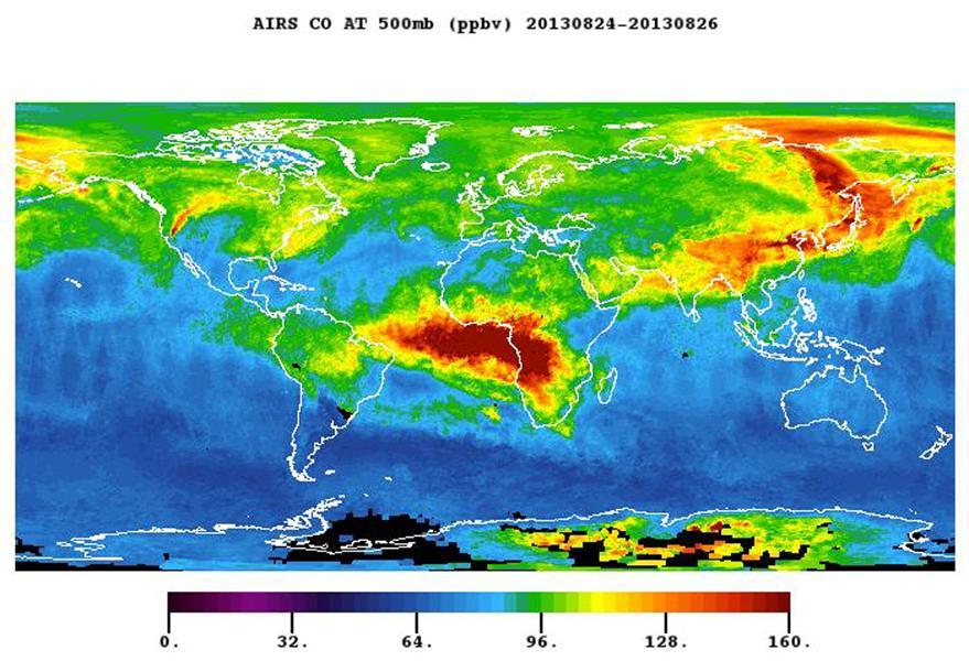
The plume of carbon monoxide pollution from the Rim Fire burning in and near Yosemite National Park, Calif., shows a three-day running average of daily measurements from NASA Aqua spacecraft.

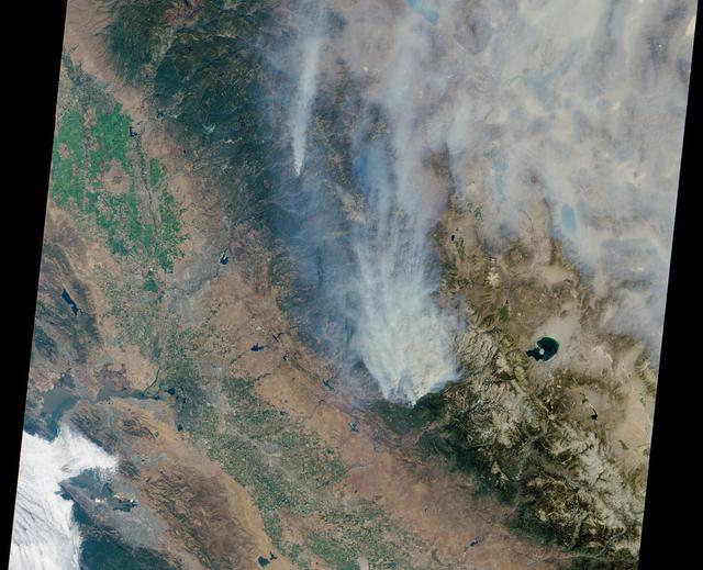
ISS036-E-035677 (24 Aug. 2013) --- One of the Expedition 36 crew members aboard the International Space Station used a 50mm lens to record this high oblique view of the massive drought-aided Rim Fire in and around California's Yosemite National Park and the Stanislaus National Forest on Aug. 24. Editor's Note: The fire began on Aug. 17 and, as of Aug. 26, continues to burn. More than 224 square miles have been affected.
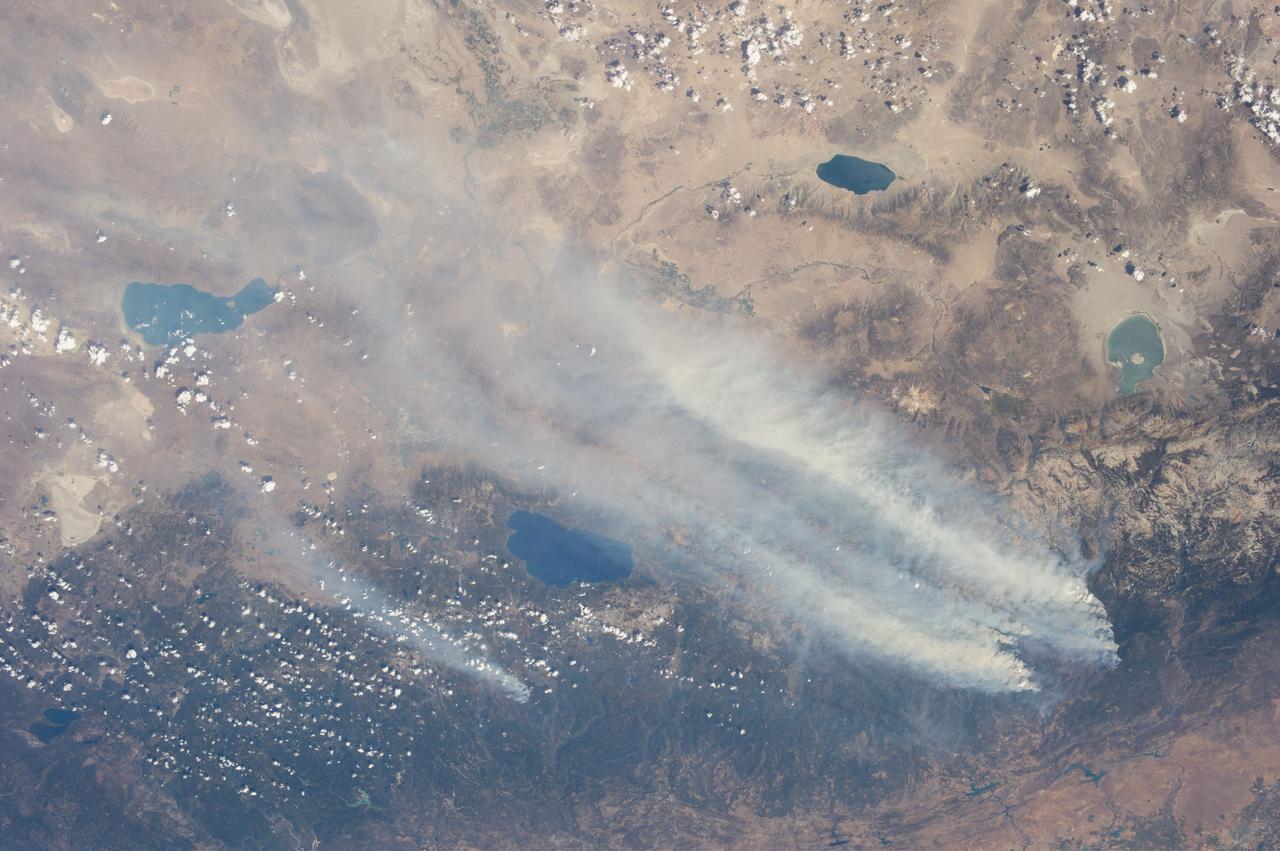
ISS036-E-037185 (26 Aug. 2013) --- One of the Expedition 36 crew members aboard the International Space Station used a 50mm lens to record this view of the massive drought-aided Rim Fire in and around California's Yosemite National Park and the Stanislaus National Forest on Aug. 26. The fire began on Aug. 17 and, at the time of this photo on Aug. 26, it still continues to burn, as some 3,700 firefighters battle it. More than 224 square miles have been affected.
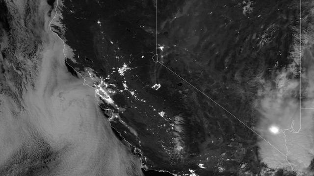
The Rim Fire burning in the Stanislaus National Forest in California has crossed into the Yosemite National Park. The fire has burned more than 105,000 acres, approximately 162 square miles, of brush, oak and pine trees in steep and marginally accessible terrain. This image was taken by the Suomi NPP satellite's Day-Night Band around 0950Z on August 23, 2013. Credit NASA/NOAA <b><a href="http://www.nasa.gov/audience/formedia/features/MP_Photo_Guidelines.html" rel="nofollow">NASA image use policy.</a></b> <b><a href="http://www.nasa.gov/centers/goddard/home/index.html" rel="nofollow">NASA Goddard Space Flight Center</a></b> enables NASA’s mission through four scientific endeavors: Earth Science, Heliophysics, Solar System Exploration, and Astrophysics. Goddard plays a leading role in NASA’s accomplishments by contributing compelling scientific knowledge to advance the Agency’s mission. <b>Follow us on <a href="http://twitter.com/NASA_GoddardPix" rel="nofollow">Twitter</a></b> <b>Like us on <a href="http://www.facebook.com/pages/Greenbelt-MD/NASA-Goddard/395013845897?ref=tsd" rel="nofollow">Facebook</a></b> <b>Find us on <a href="http://instagram.com/nasagoddard?vm=grid" rel="nofollow">Instagram</a></b>
On August 25, 2013, the Moderate Resolution Imaging Spectroradiometer (MODIS) on NASA’s Terra satellite acquired this image of the drought-fueled Rim fire burning in central California, near Yosemite National Park. Red outlines indicate hot spots where MODIS detected unusually warm surface temperatures associated with fires. Winds blew a thick smoke plume toward the northeast. A smaller fire—American fire—burned to the north. Started on August 17, 2013, the fast-moving fire had already charred more than 100,000 acres (40,000 hectares) by August 23, despite the efforts of more than 2,000 firefighters. Hundreds of people were forced to evacuate their homes, and roads in the area were closed. As of August 23, no structures had been reported destroyed, but the fire threatened the towns of Groveland and Pine Mountain Lake. By late August, wildfires had burned 3.4 million acres in the United States, making 2013 somewhat less active than other recent years. Over the last decade, fires charred 5.7 million acres on average by August 22, according to statistics published the National Interagency Fire Center. NASA image by Jeff Schmaltz, LANCE/EOSDIS Rapid Response. Caption by Adam Voiland. Instrument: Terra - MODIS Credit: <b><a href="http://www.earthobservatory.nasa.gov/" rel="nofollow"> NASA Earth Observatory</a></b> <b><a href="http://www.nasa.gov/audience/formedia/features/MP_Photo_Guidelines.html" rel="nofollow">NASA image use policy.</a></b> <b><a href="http://www.nasa.gov/centers/goddard/home/index.html" rel="nofollow">NASA Goddard Space Flight Center</a></b> enables NASA’s mission through four scientific endeavors: Earth Science, Heliophysics, Solar System Exploration, and Astrophysics. Goddard plays a leading role in NASA’s accomplishments by contributing compelling scientific knowledge to advance the Agency’s mission. <b>Follow us on <a href="http://twitter.com/NASA_GoddardPix" rel="nofollow">Twitter</a></b> <b>Like us on <a href="http://www.facebook.com/pages/Greenbelt-MD/NASA-Goddard/395013845897?ref=tsd" rel="nofollow">Facebook</a></b> <b>Find us on <a href="http://instagram.com/nasagoddard?vm=grid" rel="nofollow">Instagram</a></b>