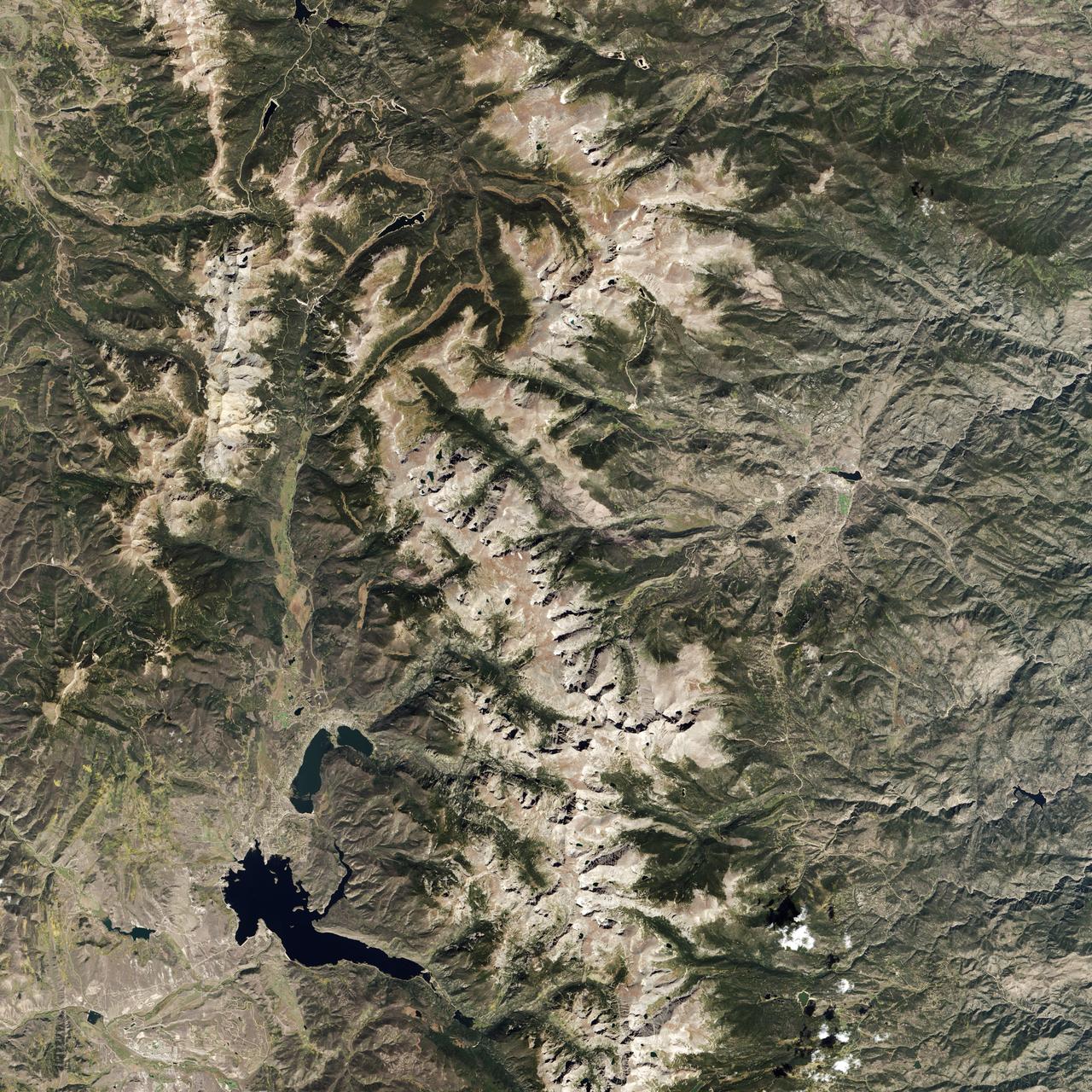
Colorado’s Rocky Mountain National Park presents a very different landscape in summertime than in wintertime. Snow retreats and gives way to blooms of wildflowers, even at high elevations. Roads and trails become accessible, allowing visitors easier access to the rugged mountain trails and vistas. The diversity of the park’s landscape is visible in this image, acquired on September 20, 2014, with the Operational Land Imager (OLI) on the Landsat 8 satellite. Except for a few patches, seasonal snow is mostly gone. Even the “Never Summer Mountains”—a range along the park’s northwest border known to receive snow any time of year—appears to be temporarily snow-free. Read more: <a href="http://go.nasa.gov/29Rmz4Y" rel="nofollow">go.nasa.gov/29Rmz4Y</a> Credit: NASA/Landsat8 <b><a href="http://www.nasa.gov/audience/formedia/features/MP_Photo_Guidelines.html" rel="nofollow">NASA image use policy.</a></b> <b><a href="http://www.nasa.gov/centers/goddard/home/index.html" rel="nofollow">NASA Goddard Space Flight Center</a></b> enables NASA’s mission through four scientific endeavors: Earth Science, Heliophysics, Solar System Exploration, and Astrophysics. Goddard plays a leading role in NASA’s accomplishments by contributing compelling scientific knowledge to advance the Agency’s mission. <b>Follow us on <a href="http://twitter.com/NASAGoddardPix" rel="nofollow">Twitter</a></b> <b>Like us on <a href="http://www.facebook.com/pages/Greenbelt-MD/NASA-Goddard/395013845897?ref=tsd" rel="nofollow">Facebook</a></b> <b>Find us on <a href="http://instagrid.me/nasagoddard/?vm=grid" rel="nofollow">Instagram</a></b>
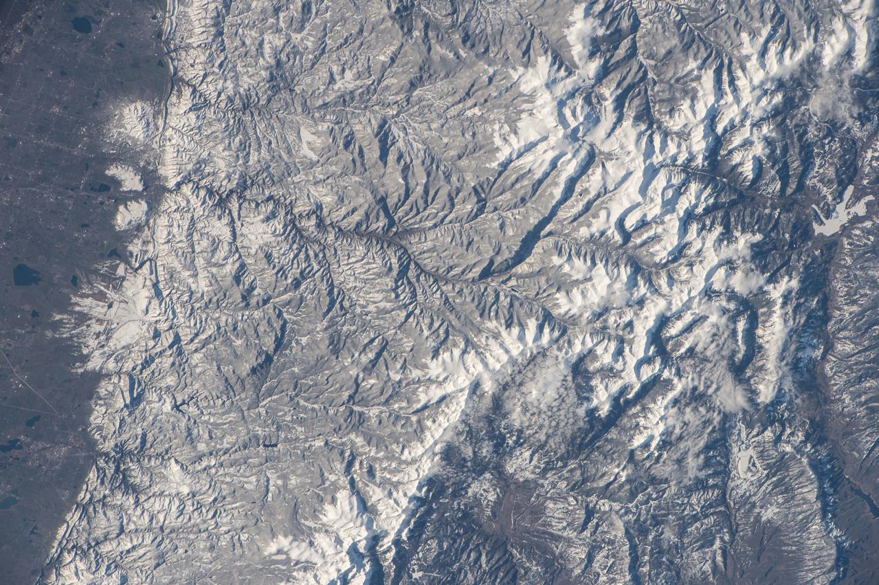
iss047e091789 (May 2, 2016) --- Rocky Mountain National Park in Colorado is pictured from the International Space Station as it orbited 252 miles above.
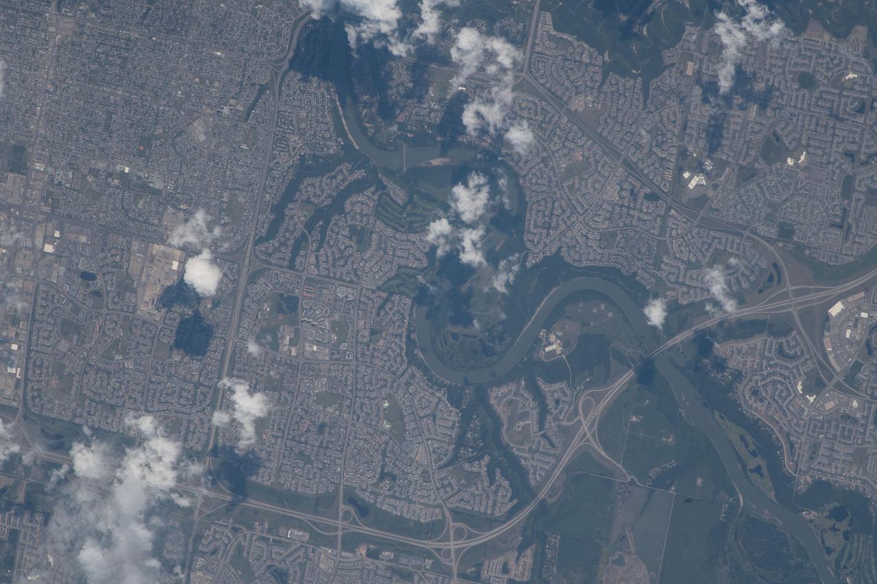
iss056e077377 (June 24, 2018) --- The North Saskatchewan River and the southwestern portion of the Canadian city of Edmonton, Alberta were pictured as the International Space Station orbited about 255 miles above Banff National Park in the Rocky Mountains.
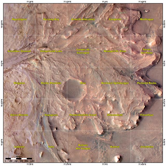
This map shows various quadrant themes in the vicinity of NASA's Perseverance Mars rover, which is currently in the Rocky Mountain quadrant within the much broader Jezero Crater. Each quadrant is 0.7 miles (1.2 kilometers) on each side. The Perseverance team chose quadrant themes related to various national parks across Earth, from Shenandoah National Park in Virginia to Jotunheimen National Park in Norway. The themes help organize the unofficial nicknames that are given by rover team members to different surface features they want to study, such as hills, craters, boulders, and even specific rock surfaces. The first sedimentary rock core sample the rover took was from a rock nicknamed "Skinner Ridge" for a ridge in Shenandoah National Park when Perseverance was in that quadrant. Many hundreds of names are compiled into a list based on each theme and are applied as the rover explores that quadrant. Rovers can sometimes end up exploring a quadrant for months, exhausting the list of names and prompting a new list to be drawn up. A key objective for Perseverance's mission on Mars is astrobiology, including the search for signs of ancient microbial life. The rover will characterize the planet's geology and past climate, pave the way for human exploration of the Red Planet, and be the first mission to collect and cache Martian rock and regolith (broken rock and dust). Subsequent NASA missions, in cooperation with ESA (European Space Agency), would send spacecraft to Mars to collect these sealed samples from the surface and return them to Earth for in-depth analysis. The Mars 2020 Perseverance mission is part of NASA's Moon to Mars exploration approach, which includes Artemis missions to the Moon that will help prepare for human exploration of the Red Planet. https://photojournal.jpl.nasa.gov/catalog/PIA25913
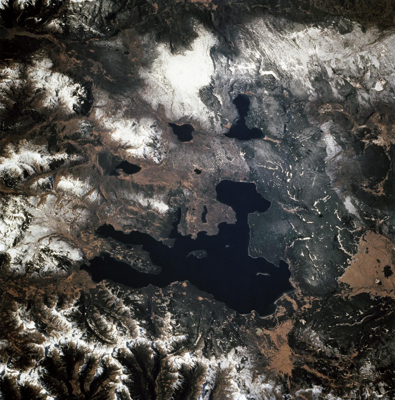
STS068-247-061 (30 September-11 October 1994) --- Photographed through the Space Shuttle Endeavour's flight windows, this 70mm frame centers on Yellowstone Lake in the Yellowstone National Park. North will be at the top if picture is oriented with series of sun glinted creeks and river branches at top center. The lake, at 2,320 meters (7,732 feet) above sea level, is the largest high altitude lake in North America. East of the park part of the Absaroka Range can be traced by following its north to south line of snow capped peaks. Jackson Lake is southeast of Yellowstone Park, and the connected Snake River can be seen in the lower left corner. Yellowstone, established in 1872 is the world's oldest national park. It covers an area of 9,000 kilometers (3,500 square miles), lying mainly on a broad plateau of the Rocky Mountains on the Continental Divide. It's average altitude is 2,440 meters (8,000 feet) above sea level. The plateau is surrounded by mountains exceeding 3,600 meters (12,000 feet) in height. Most of the plateau was formed from once-molten lava flows, the last of which is said to have occurred 100,000 years ago. Early volcanic activity is still evident in the region by nearly 10,000 hot springs, 200 geysers and numerous vents found throughout the park.

Grinding glaciers and granite peaks mingle in Chile’s Torres del Paine National Park. The Advanced Land Imager (ALI) on NASA’s Earth Observing-1 (EO-1) satellite captured this summertime image of the park on January 21, 2013. This image shows just a portion of the park, including Grey Glacier and the mountain range of Cordillera del Paine. The rivers of glacial ice in Torres del Paine National Park grind over bedrock, turning some of that rock to dust. Many of the glaciers terminate in freshwater lakes, which are rich with glacial flour that colors them brown to turquoise. Skinny rivers connect some of the lakes to each other (image upper and lower right). Cordillera del Paine rises between some of the wide glacial valleys. The compact mountain range is a combination of soaring peaks and small glaciers, most notably the Torres del Paine (Towers of Paine), three closely spaced peaks emblematic of the mountain range and the larger park. By human standards, the mountains of Cordillera del Paine are quite old. But compared to the Rocky Mountains (70 million years old), and the Appalachians (about 480 million years), the Cordillera del Paine are very young—only about 12 million years old. A study published in 2008 described how scientists used zircon crystals to estimate the age of Cordillera del Paine. The authors concluded that the mountain range was built in three pulses, creating a granite laccolith, or dome-shaped feature, more than 2,000 meters (7,000 feet) thick. NASA Earth Observatory image created by Jesse Allen and Robert Simmon, using Advanced Land Imager data from the NASA EO-1 team. Caption by Michon Scott. Instrument: EO-1 - ALI View more info: <a href="http://earthobservatory.nasa.gov/IOTD/view.php?id=80266" rel="nofollow">earthobservatory.nasa.gov/IOTD/view.php?id=80266</a> Credit: <b><a href="http://www.earthobservatory.nasa.gov/" rel="nofollow"> NASA Earth Observatory</a></b> <b><a href="http://www.nasa.gov/audience/formedia/features/MP_Photo_Guidelines.html" rel="nofollow">NASA image use policy.</a></b> <b><a href="http://www.nasa.gov/centers/goddard/home/index.html" rel="nofollow">NASA Goddard Space Flight Center</a></b> enables NASA’s mission through four scientific endeavors: Earth Science, Heliophysics, Solar System Exploration, and Astrophysics. Goddard plays a leading role in NASA’s accomplishments by contributing compelling scientific knowledge to advance the Agency’s mission. <b>Follow us on <a href="http://twitter.com/NASA_GoddardPix" rel="nofollow">Twitter</a></b> <b>Like us on <a href="http://www.facebook.com/pages/Greenbelt-MD/NASA-Goddard/395013845897?ref=tsd" rel="nofollow">Facebook</a></b> <b>Find us on <a href="http://instagrid.me/nasagoddard/?vm=grid" rel="nofollow">Instagram</a></b>
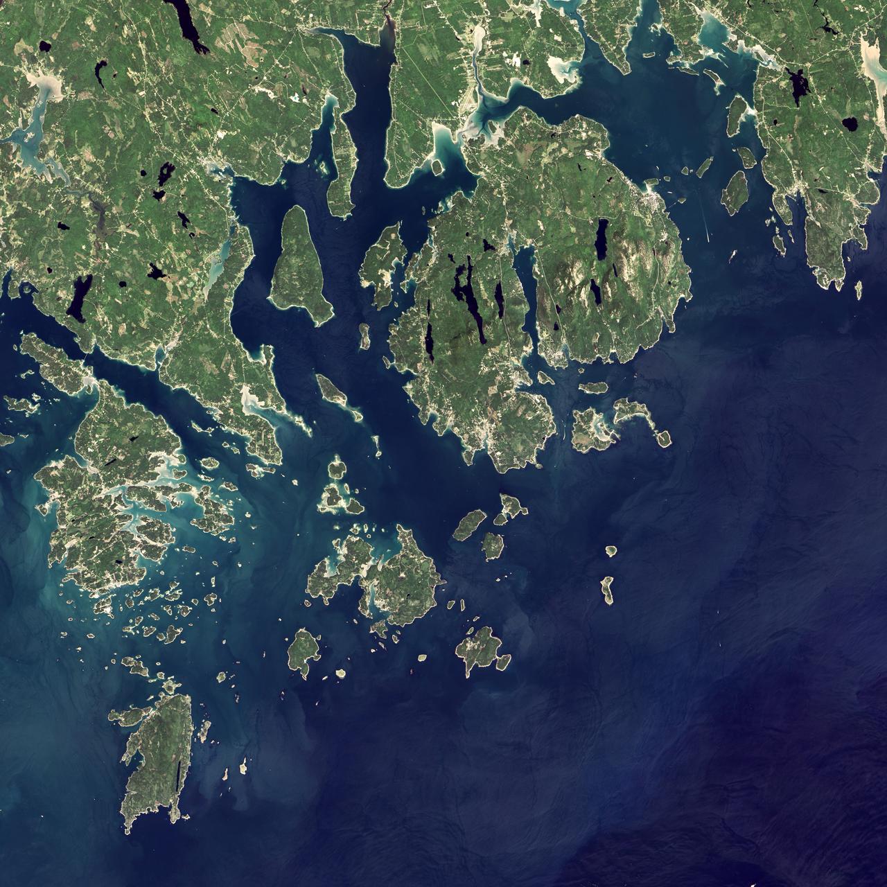
Acadia National Park is one of the most visited parks in America, drawing more than 2.5 million visitors per year to the craggy, jagged coast of Maine. The park is celebrating its 100th anniversary in 2016. On September 6, 2015, the Operational Land Imager (OLI) on the Landsat 8 satellite acquired these images of Acadia National Park and its surroundings. Mountains and hills roll right up to the Atlantic Ocean in this rocky landscape carved by glaciers at the end of the last Ice Age. Since the beginning of the 20th Century, the park has been pieced together by donations and acquisitions of once-private lands, and it is still growing. Of the park’s 47,000 acres, more than 12,000 are privately owned lands under conservation agreements, while the rest is held by the National Park Service. Mount Desert Island is the focal point of the park, which also includes lands around a former naval base (Schoodic Peninsula), Isle au Haut, and several smaller islands. Read more: <a href="http://go.nasa.gov/2adyd8J" rel="nofollow">go.nasa.gov/2adyd8J</a> Credit: NASA/Landsat8 <b><a href="http://www.nasa.gov/audience/formedia/features/MP_Photo_Guidelines.html" rel="nofollow">NASA image use policy.</a></b> <b><a href="http://www.nasa.gov/centers/goddard/home/index.html" rel="nofollow">NASA Goddard Space Flight Center</a></b> enables NASA’s mission through four scientific endeavors: Earth Science, Heliophysics, Solar System Exploration, and Astrophysics. Goddard plays a leading role in NASA’s accomplishments by contributing compelling scientific knowledge to advance the Agency’s mission. <b>Follow us on <a href="http://twitter.com/NASAGoddardPix" rel="nofollow">Twitter</a></b> <b>Like us on <a href="http://www.facebook.com/pages/Greenbelt-MD/NASA-Goddard/395013845897?ref=tsd" rel="nofollow">Facebook</a></b> <b>Find us on <a href="http://instagrid.me/nasagoddard/?vm=grid" rel="nofollow">Instagram</a></b>
On July 3, 1936, President Franklin Delano Roosevelt stood amidst the crowd in Big Meadows and officially dedicated Shenandoah National Park in Virginia. The Thematic Mapper on the Landsat satellite captured this view of the heart of Shenandoah National Park on October 10, 2010, at the height of the fall “leaf-peeping” season. The orange and brown swath across the image highlights the hilly backbone of the park, where leaves had turned to their fall colors. The 169-kilometer (105-mile) Skyline Drive that meanders across the crest of the ridge is often jammed with tourists in autumn. The park includes more than 518 miles of hiking trails, including more than 100 miles of the Appalachian Trail. The highest peak is Hawksbill Mountain at 4,051 feet (1,235 m), but the most popular with hikers is Old Rag Mountain. A circuitous eight-mile (13 kilometer) trail leads to an exposed, rocky summit 3,291 feet (1,003 meters) above sea level. The 2,200 foot elevation change from base to summit, combined with several rock scrambles, make Old Rag not only the most popular but also the most dangerous hike. Read more: <a href="http://go.nasa.gov/2bRnFxH" rel="nofollow">go.nasa.gov/2bRnFxH</a> Credit: NASA/Landsat5 <b><a href="http://www.nasa.gov/audience/formedia/features/MP_Photo_Guidelines.html" rel="nofollow">NASA image use policy.</a></b> <b><a href="http://www.nasa.gov/centers/goddard/home/index.html" rel="nofollow">NASA Goddard Space Flight Center</a></b> enables NASA’s mission through four scientific endeavors: Earth Science, Heliophysics, Solar System Exploration, and Astrophysics. Goddard plays a leading role in NASA’s accomplishments by contributing compelling scientific knowledge to advance the Agency’s mission. <b>Follow us on <a href="http://twitter.com/NASAGoddardPix" rel="nofollow">Twitter</a></b> <b>Like us on <a href="http://www.facebook.com/pages/Greenbelt-MD/NASA-Goddard/395013845897?ref=tsd" rel="nofollow">Facebook</a></b> <b>Find us on <a href="http://instagrid.me/nasagoddard/?vm=grid" rel="nofollow">Instagram</a></b>
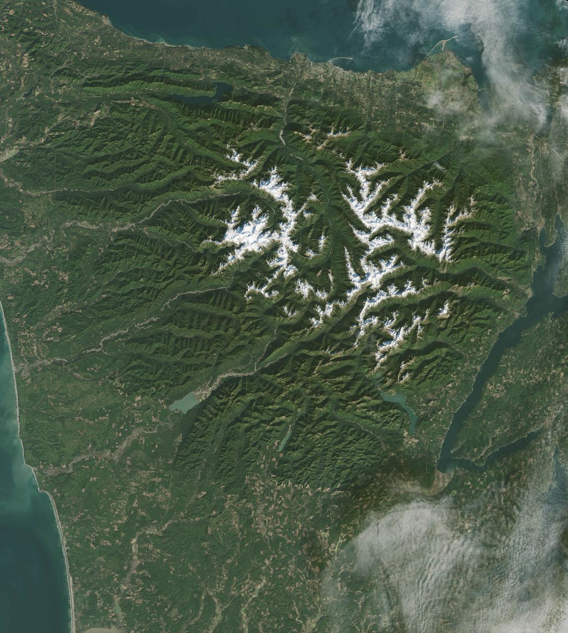
It has to be one of America’s most diverse national park landscapes. If you walked from west to east across Olympic National Park, you would start at the rocky Pacific shoreline, move into rare temperate rainforests and lush river valleys, ascend glaciers and rugged mountain peaks, and then descend into a comparatively dry rain shadow and alpine forest. From the beach to the top of Mount Olympus, you would rise 7,980 feet (2430 meters) above sea level. Situated on the Olympic Peninsula in northwestern Washington, these lands were first set aside as a national monument in 1909 by Theodore Roosevelt. Twenty-nine years later, his cousin Franklin officially established Olympic National Park. International institutions have also made a case for treasuring this land, as the area was declared an International Biosphere Reserve in 1976 and a World Heritage Site in 1981. The park encompasses nearly 923,000 acres of wild lands, including 60 named glaciers, 73 miles of coast, and 3,000 miles of rivers and streams. Read more: <a href="http://go.nasa.gov/2bRmzSJ" rel="nofollow">go.nasa.gov/2bRmzSJ</a> Credit: NASA/Landsat8 <b><a href="http://www.nasa.gov/audience/formedia/features/MP_Photo_Guidelines.html" rel="nofollow">NASA image use policy.</a></b> <b><a href="http://www.nasa.gov/centers/goddard/home/index.html" rel="nofollow">NASA Goddard Space Flight Center</a></b> enables NASA’s mission through four scientific endeavors: Earth Science, Heliophysics, Solar System Exploration, and Astrophysics. Goddard plays a leading role in NASA’s accomplishments by contributing compelling scientific knowledge to advance the Agency’s mission. <b>Follow us on <a href="http://twitter.com/NASAGoddardPix" rel="nofollow">Twitter</a></b> <b>Like us on <a href="http://www.facebook.com/pages/Greenbelt-MD/NASA-Goddard/395013845897?ref=tsd" rel="nofollow">Facebook</a></b> <b>Find us on <a href="http://instagrid.me/nasagoddard/?vm=grid" rel="nofollow">Instagram</a></b>
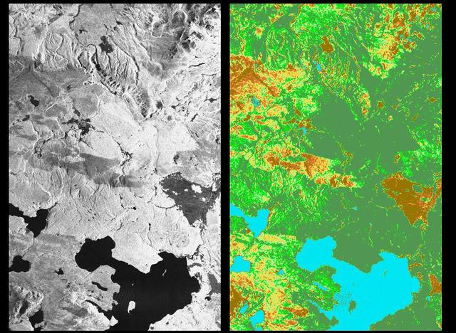
These two radar images show the majestic Yellowstone National Park, Wyoming, the oldest national park in the United States and home to the world's most spectacular geysers and hot springs. The region supports large populations of grizzly bears, elk and bison. In 1988, the park was burned by one of the most widespread fires to occur in the northern Rocky Mountains in the last 50 years. Surveys indicated that 793,880 acres of land burned. Of that, 41 percent was burned forest, with tree canopies totally consumed by the fire; 35 percent was a combination of unburned, scorched and blackened trees; 13 percent was surface burn under an unburned canopy; 6 percent was non-forest burn; and 5 percent was undifferentiated burn. Six years later, the burned areas are still clearly visible in these false-color radar images obtained by the Spaceborne Imaging Radar-C/X-band Synthetic Aperture Radar on board the space shuttle Endeavour. The image at the left was obtained using the L-band radar channel, horizontally received and vertically transmitted, on the shuttle's 39th orbit on October 2, 1994. The area shown is 45 kilometers by 71 kilometers (28 miles by 44 miles) in size and centered at 44.6 degrees north latitude, 110.7 degrees west longitude. North is toward the top of the image (to the right). Most trees in this area are lodge pole pines at different stages of fire succession. Yellowstone Lake appears as a large dark feature at the bottom of the scene. At right is a map of the forest crown, showing its biomass, or amount of vegetation, which includes foliage and branches. The map was created by inverting SIR-C data and using in situ estimates of crown biomass gathered by the Yellowstone National Biological Survey. The map is displayed on a color scale from blue (rivers and lakes with no biomass) to brown (non-forest areas with crown biomass of less than 4 tons per hectare) to light brown (areas of canopy burn with biomass of between 4 and 12 tons per hectare). Yellow indicates areas of canopy burn and mixed burn with a biomass of between 12 to 20 tons per hectare; light green is mixed burn and on-burn forest with a biomass of 20 to 35 tons per hectare; and green is non-burned forest with a biomass of greater than 35 tons per hectare. Forest recovery from the fire seems to depend on fire intensity and soil conditions. In areas of severe canopy burn and poor soil conditions, crown biomass was still low in 1994 (indicated by the brown areas at the center left), whereas in areas of mixed burn with nutrient-rich soils, seen west of Yellowstone Lake, crown biomass has increased significantly in six years (indicated by the yellow and light green areas). Imaging fire-affected regions with spaceborne radar illustrates SIR-C/X-SAR's keen abilities to monitor regrowth after a fire. Knowing the amount of carbon accumulated in the atmosphere by regenerating forest in the 20 to 50 years following a fire disturbance is also a significant factor in understanding the global carbon cycle. Measuring crown biomass is necessary to evaluate the effects of past and future fires in specific regions. http://photojournal.jpl.nasa.gov/catalog/PIA01741
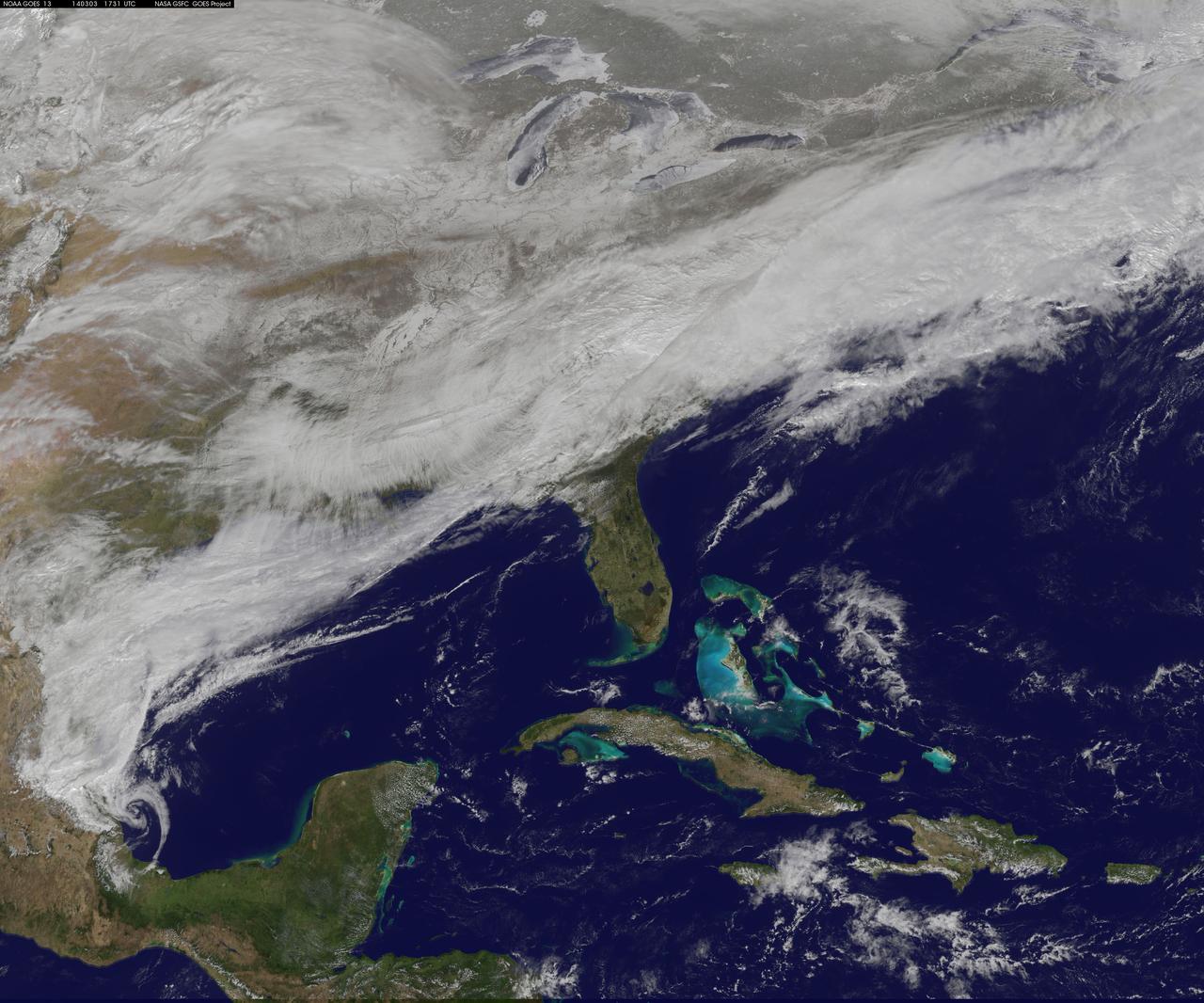
On March 3, a major winter storm brought snow to the mid-Atlantic, freezing rain to the Carolinas and rain and some freezing rain to the Gulf Coast states. NOAA's GOES-East satellite captured an image of the clouds associated with the winter storm on March 3 at 12:45 p.m. EST (1745 UTC)/ as it continued on its march over the mid-Atlantic. Bands of snow and sometimes heavy snow affected the Washington, D.C., region, Delaware and central Virginia, stretching west into West Virginia and eastern Kentucky. Snow also stretched back into the Ohio and Tennessee valleys while rain and freezing rain affected the Carolinas, and while the Gulf Coast states received rain. National Weather Service Winter Storm Warnings remained in effect until 6 p.m. EST on March 3 for Washington, D.C., and Baltimore, Md. In Richmond and Norfolk, Va., the Winter Storm warnings were in effect for six additional hours ending at midnight. On March 3, NOAA's National Weather Prediction Center in College Park, Md., noted the late-season winter storm will continue to shift eastward through the Tennessee Valley and the mid-Atlantic today, making for hazardous travel conditions. NOAA noted that unseasonably cold temperatures more typical of January will prevail east of the Rocky Mountains for the next few days keeping winter around for a while longer. The clouds are associated with a cold front that stretched from eastern Maine through Maryland and west into the Tennessee Valley. At NASA/NOAA's GOES Project at NASA's Goddard Space Flight Center in Greenbelt, Md., the cloud data from NOAA's GOES-East satellite were overlaid on a true-color image of land and ocean created by data from the Moderate Resolution Imaging Spectroradiometer, or MODIS, instrument that flies aboard NASA's Aqua and Terra satellites. Together, those data created the entire picture of the position of this major winter storm. GOES satellites provide the kind of continuous monitoring necessary for intensive data analysis. Geostationary describes an orbit in which a satellite is always in the same position with respect to the rotating Earth. This allows GOES to hover continuously over one position on Earth's surface, appearing stationary. As a result, GOES provide a constant vigil for the atmospheric "triggers" for severe weather conditions such as tornadoes, flash floods, hail storms and hurricanes. For updated information about the storm system, visit NOAA's NWS website: <a href="http://www.weather.gov" rel="nofollow">www.weather.gov</a> For more information about GOES satellites, visit: <a href="http://www.goes.noaa.gov/" rel="nofollow">www.goes.noaa.gov/</a> or goes.gsfc.nasa.gov/ Rob Gutro NASA's Goddard Space Flight Center, Greenbelt, Md. <b><a href="http://www.nasa.gov/audience/formedia/features/MP_Photo_Guidelines.html" rel="nofollow">NASA image use policy.</a></b> <b><a href="http://www.nasa.gov/centers/goddard/home/index.html" rel="nofollow">NASA Goddard Space Flight Center</a></b> enables NASA’s mission through four scientific endeavors: Earth Science, Heliophysics, Solar System Exploration, and Astrophysics. Goddard plays a leading role in NASA’s accomplishments by contributing compelling scientific knowledge to advance the Agency’s mission. <b>Follow us on <a href="http://twitter.com/NASAGoddardPix" rel="nofollow">Twitter</a></b> <b>Like us on <a href="http://www.facebook.com/pages/Greenbelt-MD/NASA-Goddard/395013845897?ref=tsd" rel="nofollow">Facebook</a></b> <b>Find us on <a href="http://instagram.com/nasagoddard?vm=grid" rel="nofollow">Instagram</a></b>