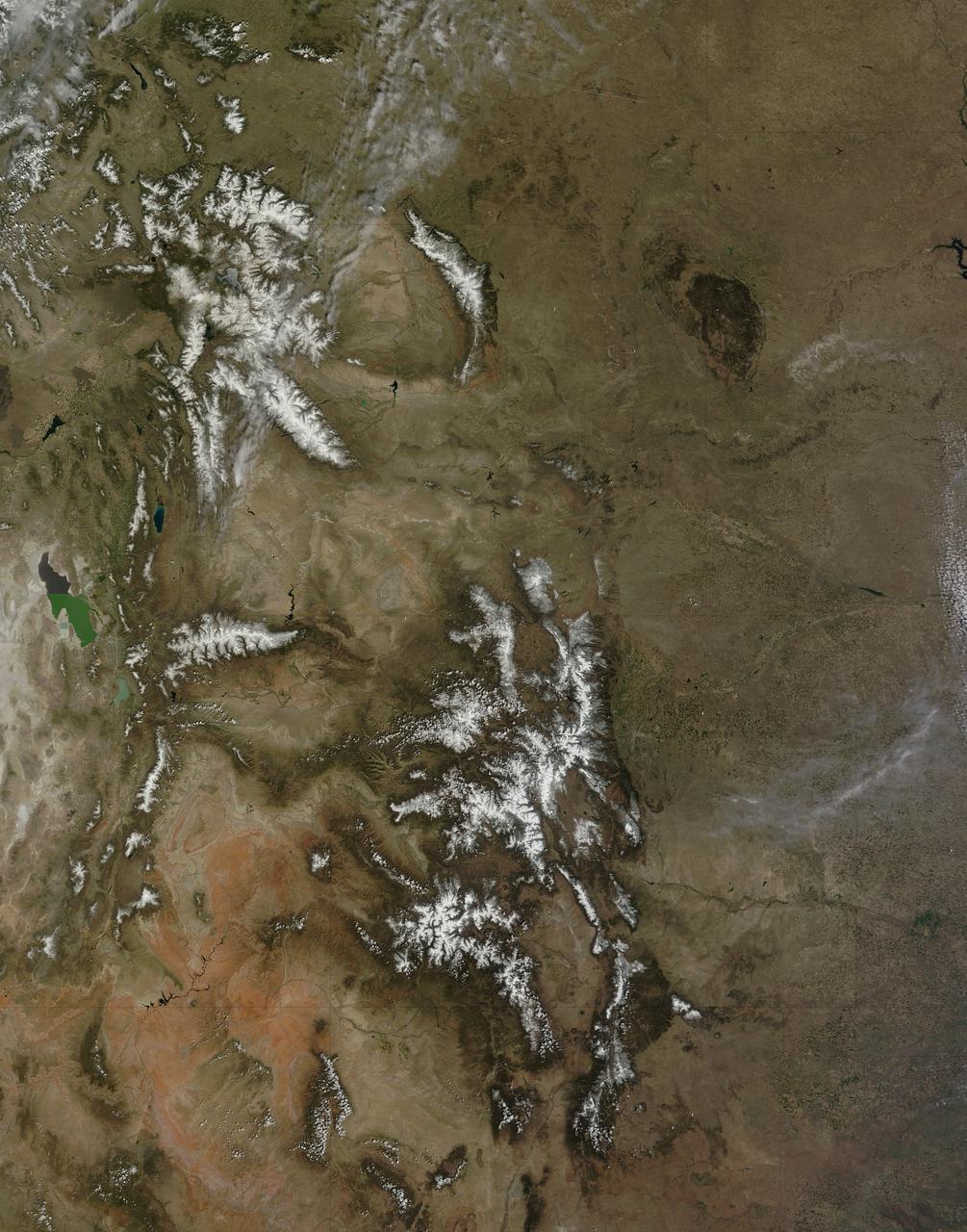
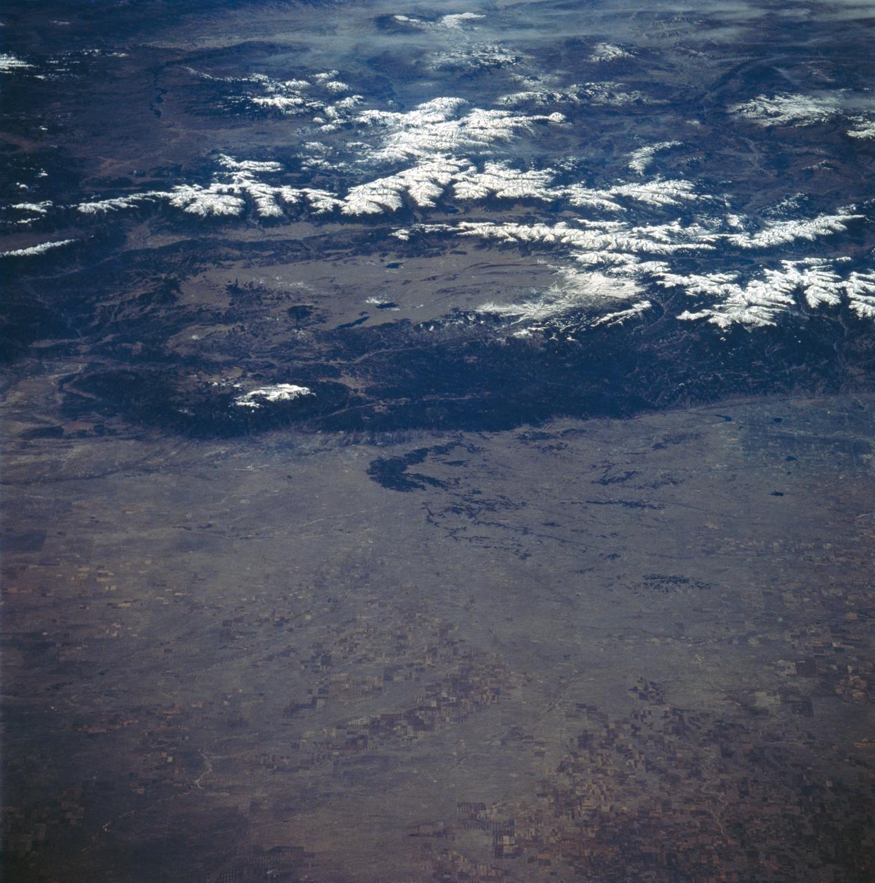
On April 29, 2015 the Moderate Resolution Imaging Spectroradiometer (MODIS) aboard NASA’s Terra satellite captured a true-color image of a typical spring scene in the western United State: snow-crowned Rocky Mountains rising above the faintly greening plains. The Rocky Mountains stretch from British Columbia, Canada to the Rio Grande in New Mexico, a span of roughly 3,000 miles, and contains many of the highest peaks in the continental United States. The tallest, Mount Elbert, rises 14,400 ft. (4,401 m) above sea level, and is located in the San Isabel National Forest, near Leadville, Colorado. This image covers seven Rocky Mountain states. From north to south they are: Montana and Idaho, Wyoming; Utah (with the Great Salt Lake visible) and Colorado; Arizona and New Mexico. To the east, the Great Plain states captured are, from north to south: North Dakota, South Dakota, Nebraska, Kansas, Oklahoma and northwestern Texas. Credit: NASA/GSFC/Jeff Schmaltz/MODIS Land Rapid Response Team <b><a href="http://www.nasa.gov/audience/formedia/features/MP_Photo_Guidelines.html" rel="nofollow">NASA image use policy.</a></b> <b><a href="http://www.nasa.gov/centers/goddard/home/index.html" rel="nofollow">NASA Goddard Space Flight Center</a></b> enables NASA’s mission through four scientific endeavors: Earth Science, Heliophysics, Solar System Exploration, and Astrophysics. Goddard plays a leading role in NASA’s accomplishments by contributing compelling scientific knowledge to advance the Agency’s mission. <b>Follow us on <a href="http://twitter.com/NASAGoddardPix" rel="nofollow">Twitter</a></b> <b>Like us on <a href="http://www.facebook.com/pages/Greenbelt-MD/NASA-Goddard/395013845897?ref=tsd" rel="nofollow">Facebook</a></b> <b>Find us on <a href="http://instagrid.me/nasagoddard/?vm=grid" rel="nofollow">Instagram</a></b>
Colorado’s Rocky Mountain National Park presents a very different landscape in summertime than in wintertime. Snow retreats and gives way to blooms of wildflowers, even at high elevations. Roads and trails become accessible, allowing visitors easier access to the rugged mountain trails and vistas. The diversity of the park’s landscape is visible in this image, acquired on September 20, 2014, with the Operational Land Imager (OLI) on the Landsat 8 satellite. Except for a few patches, seasonal snow is mostly gone. Even the “Never Summer Mountains”—a range along the park’s northwest border known to receive snow any time of year—appears to be temporarily snow-free. Read more: <a href="http://go.nasa.gov/29Rmz4Y" rel="nofollow">go.nasa.gov/29Rmz4Y</a> Credit: NASA/Landsat8 <b><a href="http://www.nasa.gov/audience/formedia/features/MP_Photo_Guidelines.html" rel="nofollow">NASA image use policy.</a></b> <b><a href="http://www.nasa.gov/centers/goddard/home/index.html" rel="nofollow">NASA Goddard Space Flight Center</a></b> enables NASA’s mission through four scientific endeavors: Earth Science, Heliophysics, Solar System Exploration, and Astrophysics. Goddard plays a leading role in NASA’s accomplishments by contributing compelling scientific knowledge to advance the Agency’s mission. <b>Follow us on <a href="http://twitter.com/NASAGoddardPix" rel="nofollow">Twitter</a></b> <b>Like us on <a href="http://www.facebook.com/pages/Greenbelt-MD/NASA-Goddard/395013845897?ref=tsd" rel="nofollow">Facebook</a></b> <b>Find us on <a href="http://instagrid.me/nasagoddard/?vm=grid" rel="nofollow">Instagram</a></b>
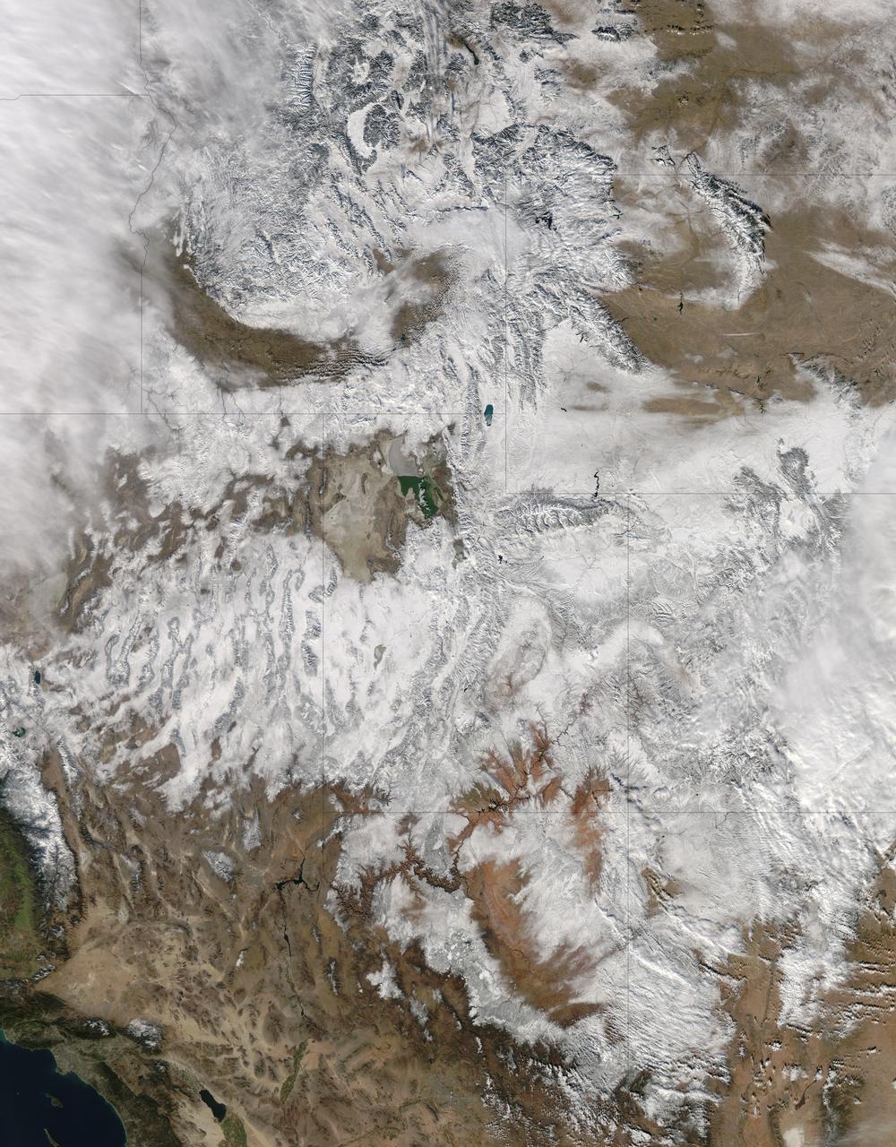
NASA image acquired December 19, 2012 In time for the 2012 winter solstice, a storm dropped snow over most of the Rocky Mountains in the United States. On December 20, the National Weather Service reported snow depths exceeding 100 centimeters (39 inches) in some places—the result of the recent snowfall plus accumulation from earlier storms. The Moderate Resolution Imaging Spectroradiometer (MODIS) on NASA’s Aqua satellite captured this natural-color image on December 19, 2012. Clouds had mostly cleared from the region, though some cloud cover lingered over parts of the Pacific Northwest and Colorado. Showing more distinct contours than the clouds, the snow cover stretched across the Rocky Mountains and the surrounding region, from Idaho to Arizona and from California to Colorado. Snowfall did not stop in Colorado, as the storm continued moving eastward across the Midwest. By December 20, 2012, a combination of heavy snow and strong winds had closed schools, iced roads, and delayed flights, complicating plans for holiday travelers. Though troublesome for travel, the snow brought much-needed moisture; multiple cities had set new records for consecutive days without measurable snow, CBS news reported. As of December 18, the U.S. Drought Monitor stated that a substantial portion of the continental United States continued to suffer from drought, and “exceptional” drought conditions extended from South Dakota to southern Texas. NASA image courtesy Jeff Schmaltz, LANCE MODIS Rapid Response. Caption by Michon Scott. Instrument: Aqua - MODIS To read more go to: <a href="http://earthobservatory.nasa.gov/IOTD/view.php?id=80035" rel="nofollow">earthobservatory.nasa.gov/IOTD/view.php?id=80035</a> Credit: <b><a href="http://www.earthobservatory.nasa.gov/" rel="nofollow"> NASA Earth Observatory</a></b> <b><a href="http://www.nasa.gov/audience/formedia/features/MP_Photo_Guidelines.html" rel="nofollow">NASA image use policy.</a></b> <b><a href="http://www.nasa.gov/centers/goddard/home/index.html" rel="nofollow">NASA Goddard Space Flight Center</a></b> enables NASA’s mission through four scientific endeavors: Earth Science, Heliophysics, Solar System Exploration, and Astrophysics. Goddard plays a leading role in NASA’s accomplishments by contributing compelling scientific knowledge to advance the Agency’s mission. <b>Follow us on <a href="http://twitter.com/NASA_GoddardPix" rel="nofollow">Twitter</a></b> <b>Like us on <a href="http://www.facebook.com/pages/Greenbelt-MD/NASA-Goddard/395013845897?ref=tsd" rel="nofollow">Facebook</a></b> <b>Find us on <a href="http://instagram.com/nasagoddard?vm=grid" rel="nofollow">Instagram</a></b>
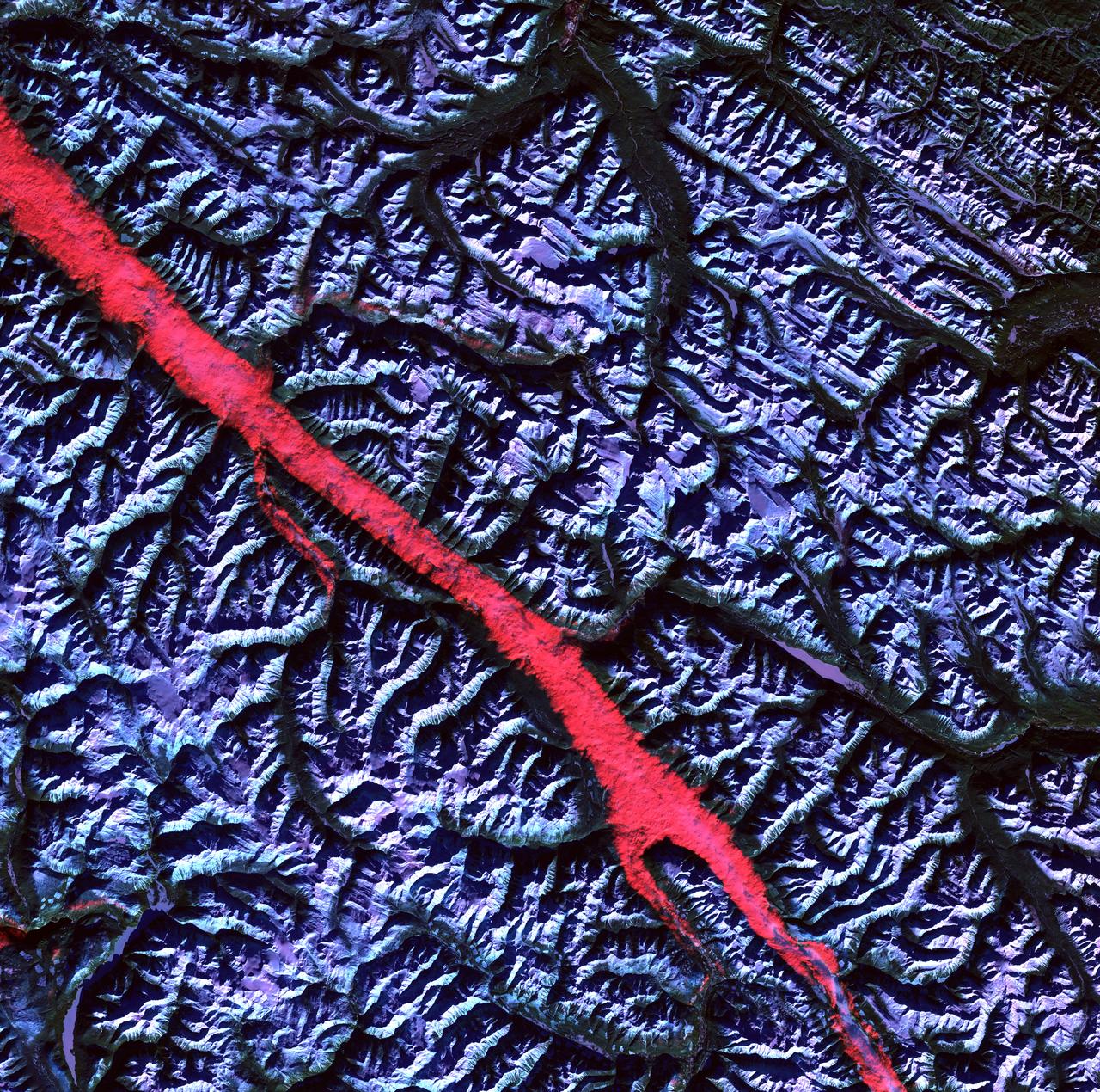
Acquisition Date: February 2004 The high reflectance of clouds compared to the surrounding land, coupled with the low sun elevation when this image was acquired, causes low clouds to appear red as they fill a portion of the Rocky Mountain Trench. Running parallel with the peaks of the Canadian Rockies and ranging from 2 to 10 miles (3 to 16 kilometers) wide and about 900 miles (1,448 kilometers) long, the Trench aligns with the Fraser River and makes its way past Mount Robson, the highest peak in the Canadian Rockies at 12,972 feet (3,954 meters). Mount Robson is near the center of this image. Credit: NASA/GSFC/Landsat/USGS To learn more about Landsat and to see the orginal high res file go to: <a href="http://landsat.usgs.gov/gallery_view.php?category=greenflag&thesort=mainTitle" rel="nofollow">landsat.usgs.gov/gallery_view.php?category=greenflag&...</a>
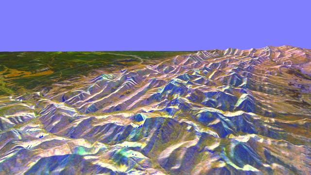
This is a three-dimensional perspective of the eastern front range of the Rocky Mountains, about 120 kilometers 75 miles west of Great Falls, Montana.
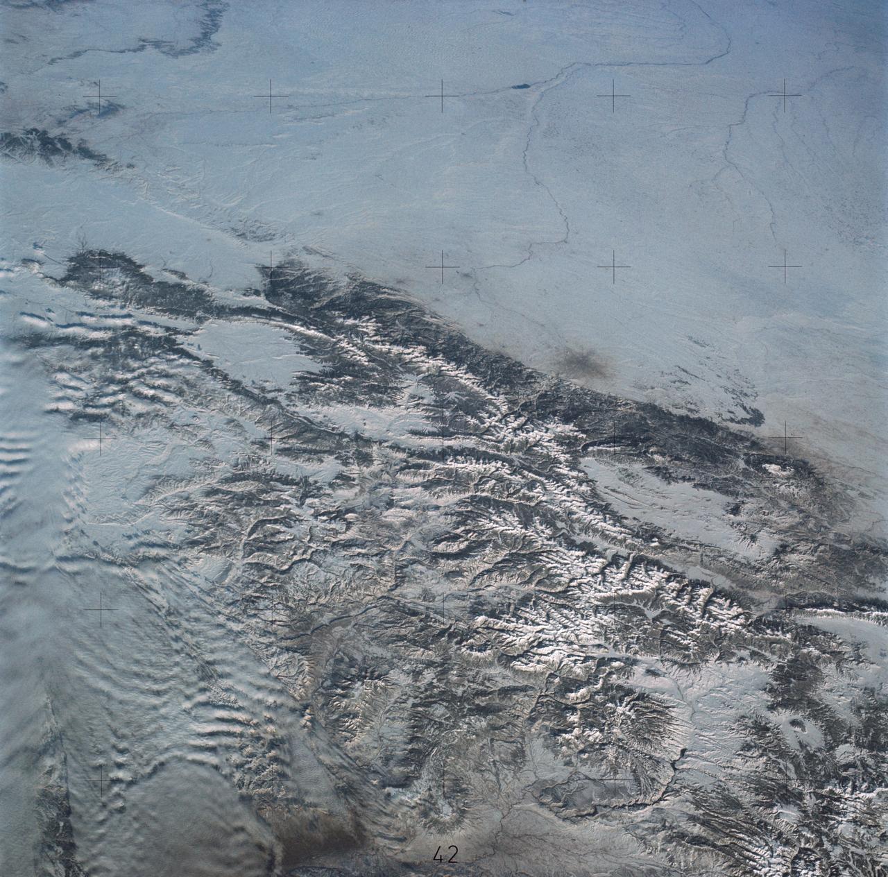
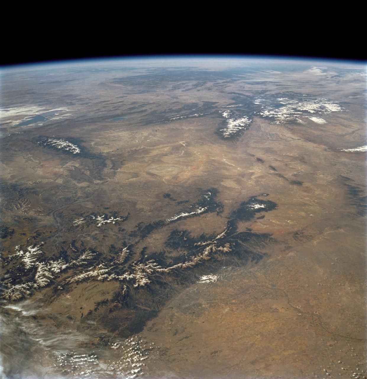
SL4-138-3875 (February 1974) --- A color oblique photograph looking east over the Rocky Mountains and Great Plains. This view covers a portion of the States of Colorado, Wyoming, and Nebraska. A Skylab 4 crewmen took this picture with a hand-held 70mm Hasselblad camera. This entire region, covered with a blanket of snow, depicts much of the structural and topographic features of the Rocky Mountain chain. Man's only apparent change to the snow pattern seen here is the (right center) metropolitan areas of Denver and Colorado Springs, Colorado, which can be observed along the eastern edge of the mountain front. Grand Junction, Colorado on the western slope of the Rocky Mountains is just off the photograph at left center bottom. The major inter-montane valleys of South Park (right center), Middle Park (center), and North Park (left center) are clearly visible and separate the Colorado Rockies Front Range from the high rugged mountains can be discovered such as Pikes Peak near right border (center), Mt. Cunnison region, circular feature accentuated by the Cunnison River (dark) in the right center (bottom) of the photograph. The snow covered peaks of Mts. Harvard, Princeton and Yale form the high region of the Collegiate Range which is the pronounced mountain area in the right center. Snow cover not only enhances mountain features but also the drainage patterns. East of Denver (right corner) the sinuous trace of the South Platte River (center) and its junction with the North Platte River near North Platte, Nebraska. Lake McConaughy in Nebraska is the body of water (black) near the river intersection. The trace of the Republic River in southern Nebraska is visible near the right corner of the photography. Geologic and hydro logic studies using this photograph will be conducted by Dr. Roger Morrison, U.S. Geological Survey. Photo credit: NASA
iss073e0420556 (Aug. 3, 2025) --- From bottom to top, or from west to east in this orientation, California's Central Valley extends across the bottom of this photograph and just above the San Francisco Bay Area. Past the Central Valley is the Sierra Nevada mountain range that leads into Nevada's Great Basin region and eastward toward the Rocky Mountains. The International Space Station was soaring 260 miles above the Pacific Ocean at the time of this photograph.
AST-19-1570 (24 July 1975) --- An oblique view of the Rocky Mountains area of British Columbia and Alberta in Canada, as photographed from the Apollo spacecraft in Earth orbit during the joint U.S.-USSR Apollo-Soyuz Test Project mission. This picture was taken at an altitude of 222 kilometers (138 statute miles) with a 70mm Hasselblad camera using medium-speed Ektachrome QX-807 type film.
STS103-730-032 (19-27 December 1999) --- One of the astronauts aboard the Earth-orbiting Space Shuttle Discovery used a handheld 70mm camera to capture the southern to middle Rocky Mountains in low sunlight. The middle Rockies include the Big Horn range of Wyoming (snow capped range almost center of horizon) and the Unita Mountains of northeastern Utah (snow capped range left side of horizon). The southern Rockies includes the Front Range, Sangre de Cristo Mountains, Sawatch Ranges, and the San Juan Mountains. The eastern (Front Range, Sangre de Cristo) and western ranges (Sawatch, San Juan's) are separated by intermontane basins. The southernmost basin (near center of the image) is the San Luis Valley of Colorado. On the eastern edge of the San Luis Valley are the Sangre de Cristo Mountains.
iss047e091789 (May 2, 2016) --- Rocky Mountain National Park in Colorado is pictured from the International Space Station as it orbited 252 miles above.
iss073e0420598 (Aug. 3, 2025) --- Bighorn National Forest in Wyoming and Custer National Forest in Montana, located in the Rocky Mountains region of the United States, are pictured from the International Space Station as it orbited 261 miles above.
iss063e080437 (Aug. 26, 2020) --- The International Space Station was orbiting above North America when an Expedition 63 crew member, looking from northeast to southwest, photographed the Rocky Mountains running from Canada and into the United States.
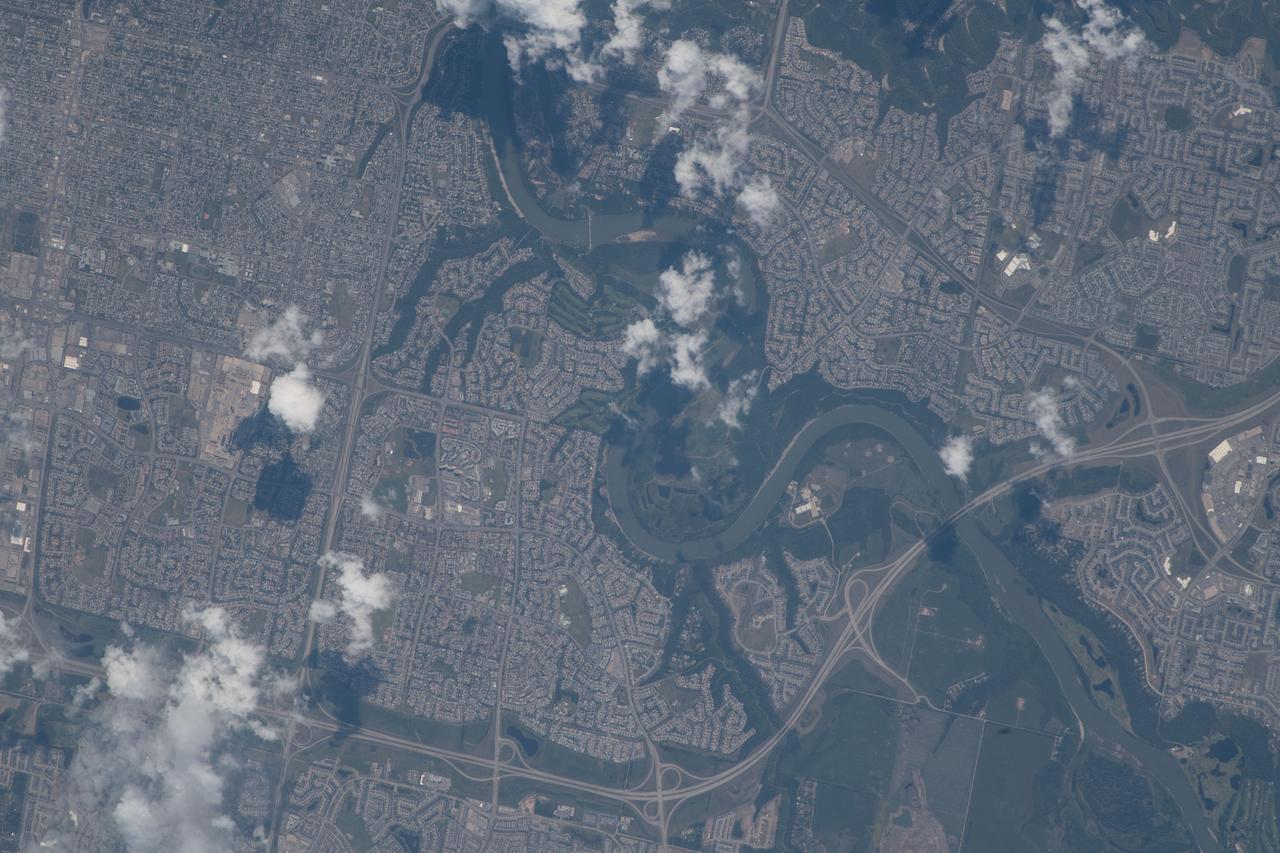
iss056e077377 (June 24, 2018) --- The North Saskatchewan River and the southwestern portion of the Canadian city of Edmonton, Alberta were pictured as the International Space Station orbited about 255 miles above Banff National Park in the Rocky Mountains.
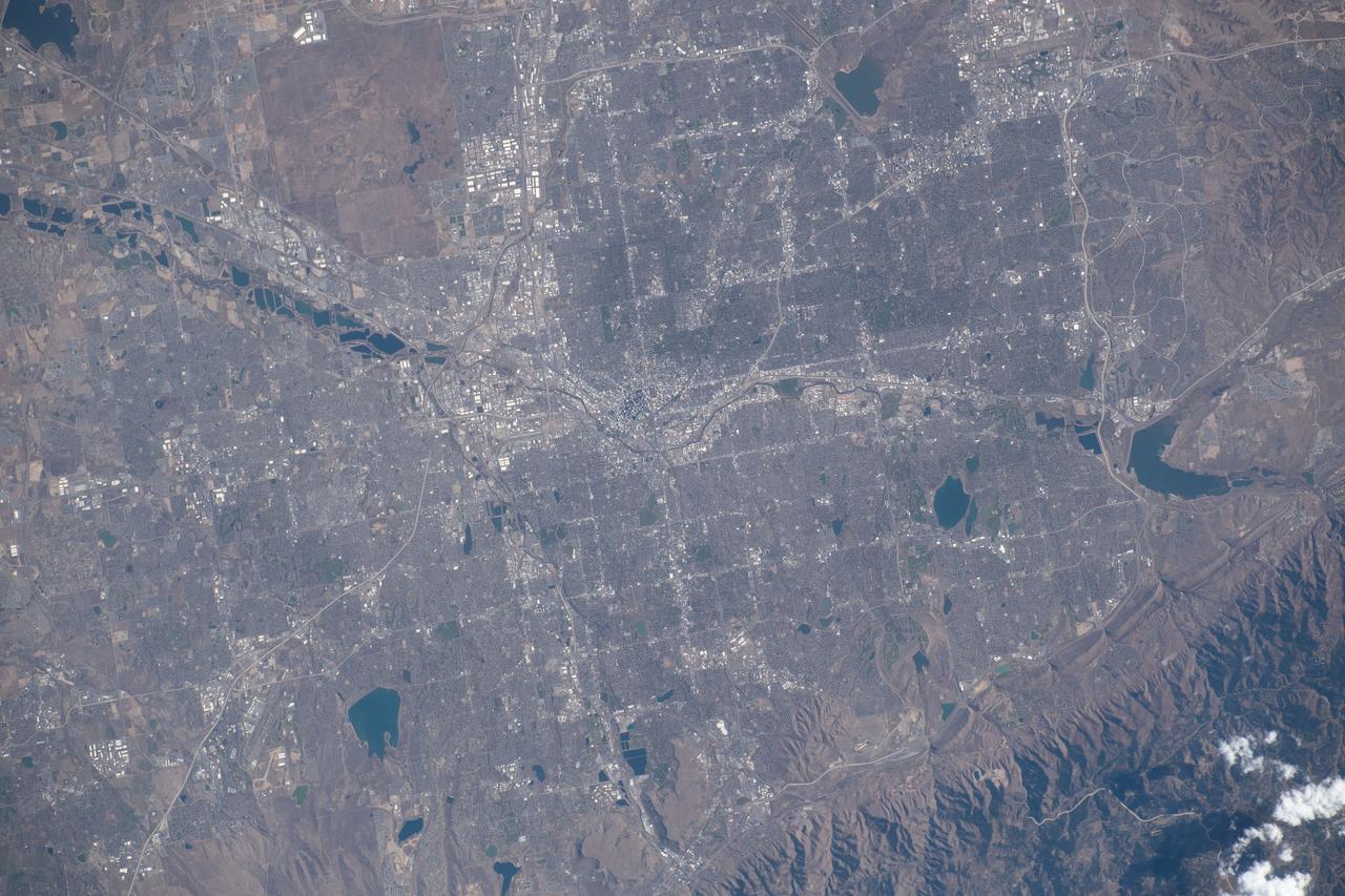
iss070e008429 (Oct. 22, 2023) --- Denver, Colorado, split by the South Platte River and next to the Rocky Mountains, is pictured from the International Space Station as it orbited 262 miles above the Centennial State.

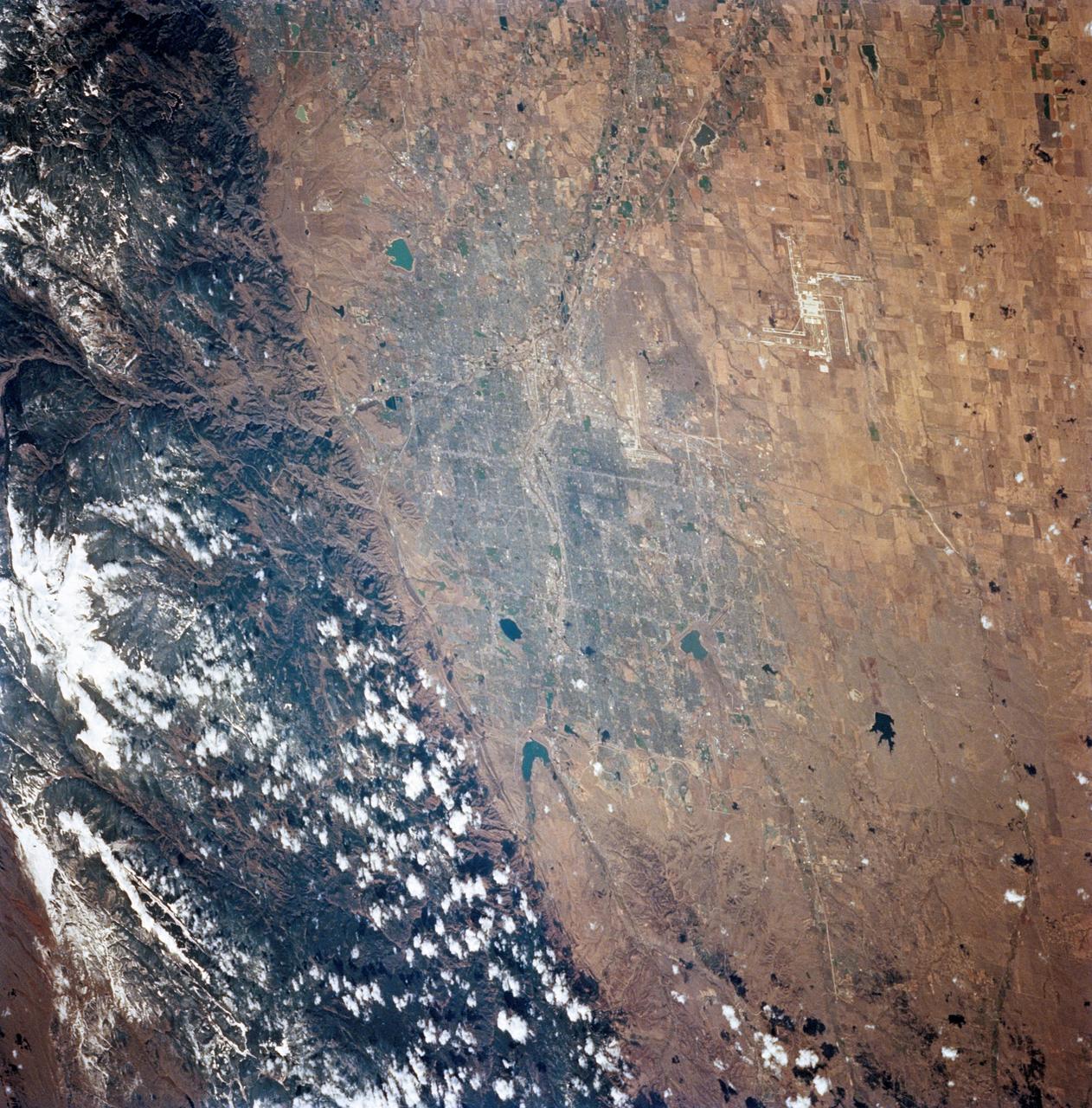
iss072e010455 (Oct. 2, 2024) --- The Denver, Colorado, metropolitan area sits near the eastern foothills of the Rocky Mountains in this photograph from the International Space Station as it orbited 258 miles above the Centennial State.
STS058-89-013 (18 Oct-1 Nov 1993) --- An oblique westward view, across the wheat fields and cattle pastures, of eastern Colorado to the Front Range of the Rocky Mountains. Denver is bisected at the center of the right edge of the frame. Pikes Peak and Colorado Springs are left of center, and the Arkansas River Valley with Canyon City and the Royal Gorge are along the left edge of the frame. This view shows the startling contrast between the nearly-flat High Plains and the ancient geological uplift of the Rockies.
STS081-719-084 (12-22 Jan. 1997) --- The capital of the state of Colorado is featured prominently in this winter scene. Located at the foothills of the Rocky Mountains, Denver's elevation is 5,280 feet and is known as the "Mile High City". The new Denver International Airport (DIA) opened in 1995 and is one of the countries largest airports, can be seen towards the right corner of the photograph. Above and to the right of DIA is the closed Stapleton Airport with its snow covered runways. Other prominent cities featured are Golden, due east of Denver and against the Rockies, and Boulder, to the northeast of the city and also against the Rockies. Brighton is northwest of Denver, near the South Platte River.

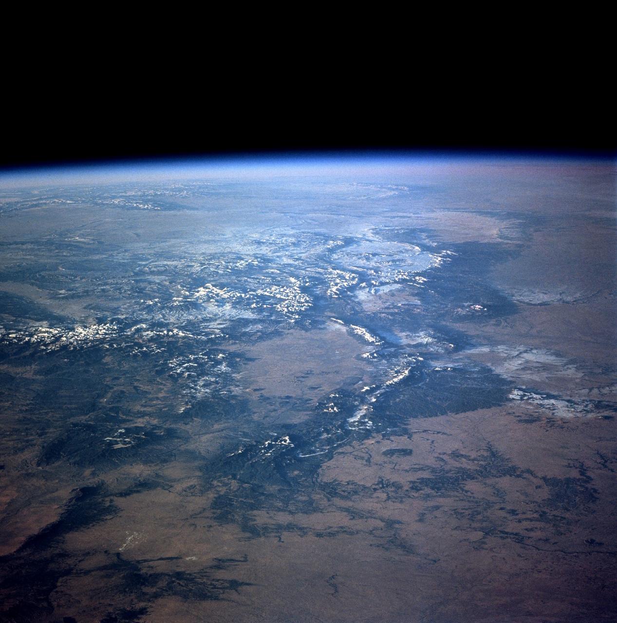
ISS007-E-17557 (17 October 2003) --- This sweeping view of the Rocky Mountains and the western US was taken when the International Space Station (ISS) traveled over eastern Washington on October 17, 2003. The POV of the Station was looking southeast over the mountains of Idaho (foreground) and Wyoming (Yellowstone, the Tetons and the Wind River Range are just right and above the center of the image). Great Salt Lake is in the lower right of the image.
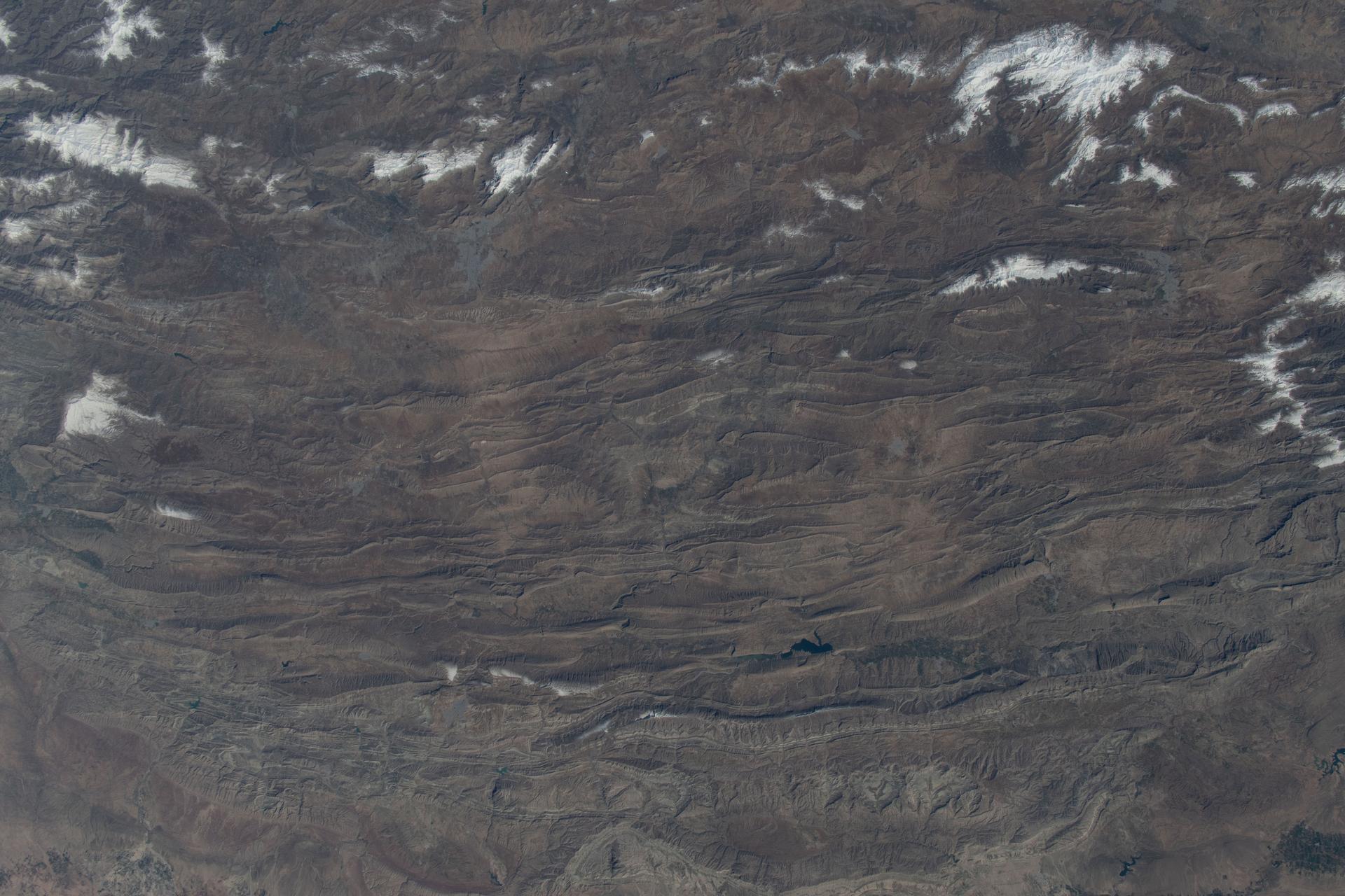
iss074e0315889 (Feb. 16, 2026) --- A portion of the rugged Zagros Mountain range, featuring narrow valleys and rocky outcrops in the semi-arid region of western Iran, is pictured from the International Space Station as it orbited 259 miles above Earth. Credit: NASA/Chris Williams

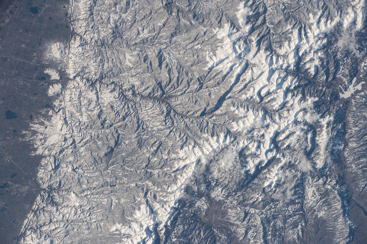
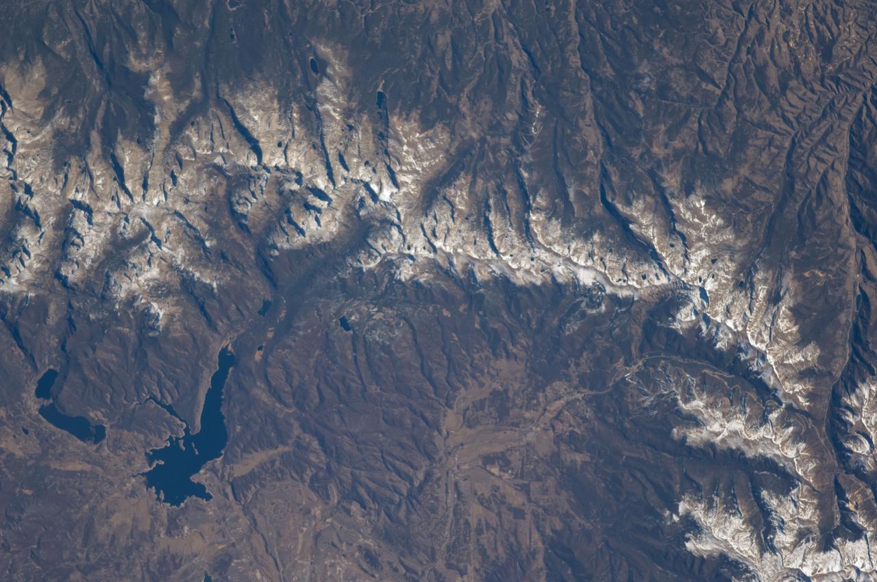
iss064e002041 (Oct. 27, 2020) --- The International Space Station was orbiting above southern Colorado when an external high-definition camera photographed several snow-capped peaks along a portion of the Rocky Mountain range including Cottonwood Peak near the top left, to Blanca Peak and Mount Lindsey near the bottom right.
ISS018-E-005660 (28 Oct. 2008) --- The Great Divide of the Rocky Mountains in Colorado is featured in this image photographed by an Expedition 18 crewmember on the International Space Station. This view highlights a portion of the Great Divide in the Rocky Mountains approximately 31 kilometers due west of Boulder, Colorado. The Great Divide is one of four continental divides recognized by geographers and hydrologists in North America -- the others being the Northern, Eastern, and Saint Lawrence Seaway Divides -- but it is still generally (and erroneously) known as "the" Continental Divide. The Great Divide is a hydrologic boundary defined by the ultimate destination of precipitation -- rainfall on the western side of the Divide flows to the Pacific Ocean, while rainfall on the eastern side of the Divide flows to the Gulf of Mexico. It is easy to visualize such a boundary traced along the high ridges of the Rocky Mountains, but in regions of less topography more detailed study of the local geomorphology and hydrology are required to map the location of the Divide. This portion of the Rocky Mountains also hosts the Niwot Ridge Long Term Ecological Research (LTER) site. Part of the National Science Foundation LTER program, the Niwot Ridge LTER site studies climate interactions with tundra and alpine ecosystems. Niwot Ridge is visible in this image as a large eastward spur off the central spine of the mountains. The entire Niwot LTER site is located at elevations higher than 3000 m, and includes an active cirque glacier and glacial landforms, tarns (glacial lakes), and permafrost. Lake Granby, located to the west of the Great Divide, is a reservoir on the Colorado River and the second-largest manmade body of water in the state of Colorado. Storage of water began in 1949. Today, the Lake is popular location for fishing, boating and camping.
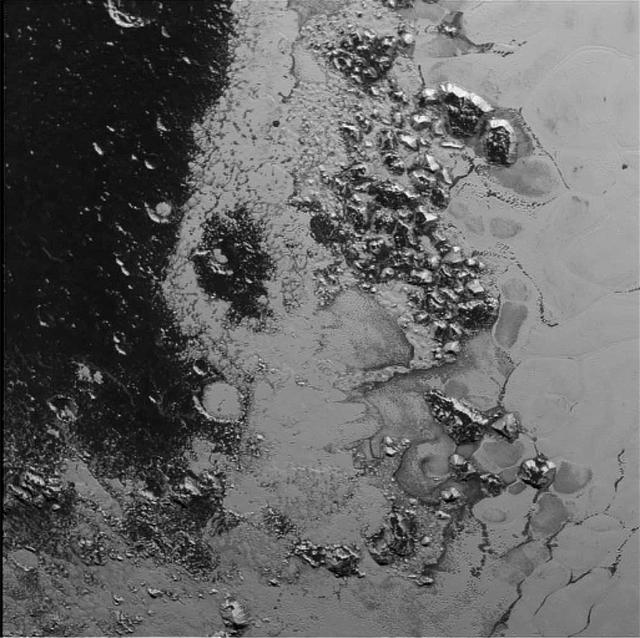
A newly discovered mountain range lies near the southwestern margin of Pluto heart-shaped Tombaugh Regio Tombaugh Region, situated between bright, icy plains and dark, heavily-cratered terrain. This image was acquired by NASA's New Horizons' Long Range Reconnaissance Imager (LORRI) on July 14, 2015, from a distance of 48,000 miles (77,000 kilometers) and sent back to Earth on July 20. Features as small as a half-mile (1 kilometer) across are visible. These frozen peaks are estimated to be one-half mile to one mile (1-1.5 kilometers) high, about the same height as the United States' Appalachian Mountains. The Norgay Montes (Norgay Mountains) discovered by New Horizons on July 15 more closely approximate the height of the taller Rocky Mountains The names of features on Pluto have all been given on an informal basis by the New Horizons team. http://photojournal.jpl.nasa.gov/catalog/PIA19842
STS112-708-002 (7-18 October 2002) --- This image, photographed from the Earth-orbiting Space Shuttle Atlantis, covers parts of Utah, Colorado, Wyoming and Idaho. The Front Range of the Rockies is the dark range crossing the bottom of the view, with Denver and neighboring cities (grays) situated in the gentle embayment of the mountains (bottom center of the view). Great Salt Lake in Utah appears as two colors of blue top left, with the snow-covered Uinta Mountains just below, in this northwesterly view. Most of the view encompasses the brown plains of western Wyoming (center) and the cluster of mountains around Yellowstone (top center, top right, with snow). Beyond the brown Snake River Plain, black rocks of the Sawtooth Mountains and neighboring ranges of central Idaho appear top center.
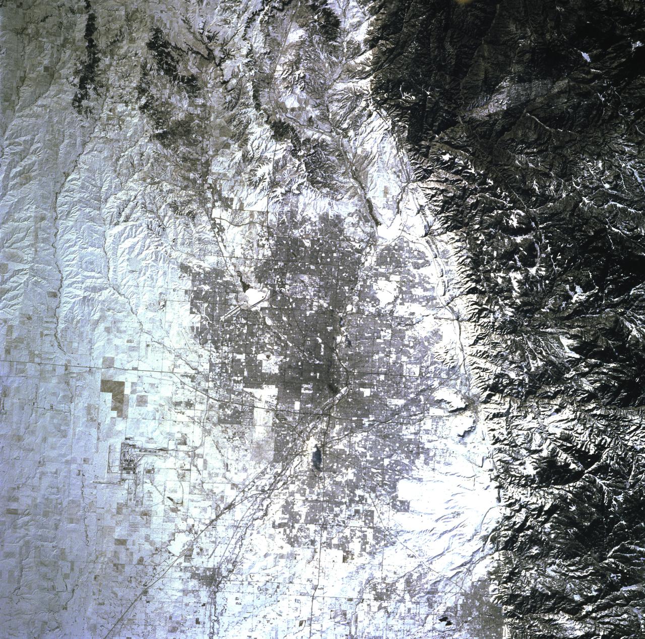
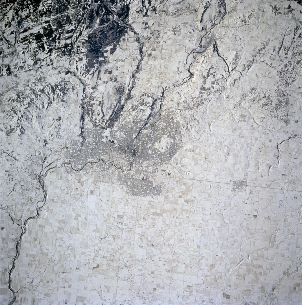
STS068-248-092 (30 September-11 October 1994) --- The location of Denver, Colorado - on the western edge of the High Plains, at the junction of the South Platte River and Clear Creek east of the Rocky Mountains - is graphically displayed. Mount Evans and its surroundings are already covered by snow on October 8, 1994. Clear Creek was one of the first areas in the Rockies where gold was discovered by American prospectors in the 19th century, which led to the settlement of Denver. The growth of 20th century Denver, dominantly to the west and south, is apparent. Stapleton Field, close to downtown Denver, is being replaced by the new regional airport well out on the plains.
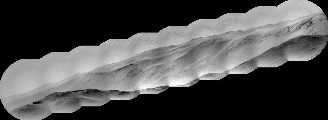
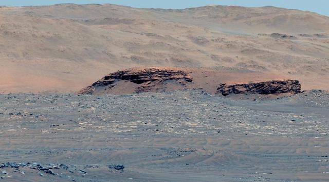
NASA's Curiosity Mars rover captured this view of a mountain nearly 57 miles (91 kilometers) away and outside of Gale Crater, where Curiosity landed in 2012. The rover is currently in the foothills of Mount Sharp, a 3-mile-tall (5-kilometer-tall) mountain within the crater. Estimated to be 8,202 feet (2,500 meters) tall, the mountain's summit just peeks over the crater rim in the panorama. It has never been viewed with this much detail. Toward the lower left, dark rocky outcrops are visible. Curiosity captured the view with its black-and-white Remote Micro Imager, or RMI. Part of the rover's ChemCam instrument, RMI can be used like a small telescope to see distant features, creating a circular "spyglass" view. Ten RMI images taken on Aug. 28, 2025 (the 4,643rd Martian day, or sol of the mission) were stitched together to create the mosaic. https://photojournal.jpl.nasa.gov/catalog/PIA26638
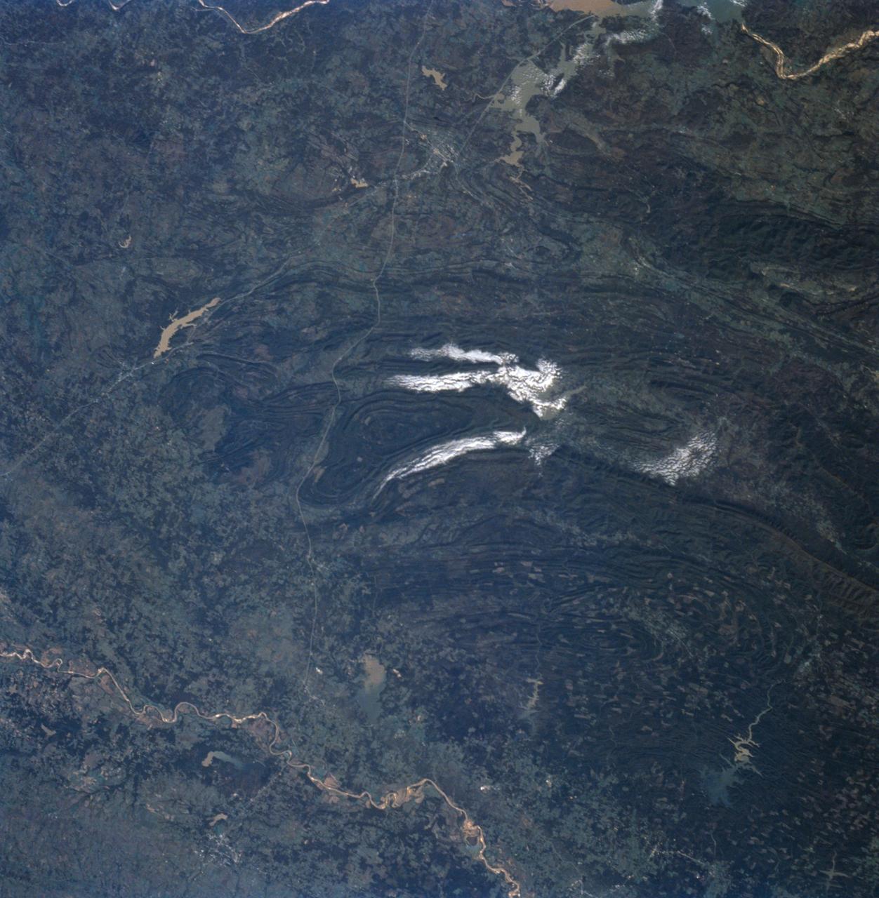
STS058-91-058 (18 Oct-1 Nov 1993) --- In this unusually clear view, the Ouachita Mountains of southeastern Oklahoma are framed on the north by Lake Eufaula on the South Canadian River, and on the south by the Red River. Sandstone, shale and chert (similar to flint) deposited in a sea several thousand feet deep were squeezed up to form the mountains about 250 million years ago. During the ensuing time, erosion of the western end of the Ouachita Mountains has emphasized linear ridges of resistant rock in the plunging anticlines and synclines, causing relief of 800 meters (2,600 feet) or more. Clouds formed by upslope winds border both the north and south sides of one of the most dramatic plunging synclines (in a syncline the rock layers dip toward the center of the structure). Toward the west, densely forested mountains give way to gently rolling, less rocky terrain and a drier climate which is better suited to farming. The mountains centered on Broken Bow, in the lower right corner of the scene, display abundant timber clearcuts that are being regenerated.

In the Space Life Sciences Laboratory at NASA's Kennedy Space Center in Florida, student interns such as Ayla Grandpre, left, and Payton Barnwell are joining agency scientists, contributing in the area of plant growth research for food production in space. Grandpre is pursuing a degree in computer science and chemistry at Rocky Mountain College in Billings, Montana. Barnwell is a mechanical engineering and nanotechnology major at Florida Polytechnic University. The agency attracts its future workforce through the NASA Internship, Fellowships and Scholarships, or NIFS, Program.

In the Space Life Sciences Laboratory at NASA's Kennedy Space Center in Florida, student interns such as Ayla Grandpre are joining agency scientists, contributing in the area of plant growth research for food production in space. Grandpre is majoring in computer science and chemistry at Rocky Mountain College in Billings, Montana. The agency attracts its future workforce through the NASA Internship, Fellowships and Scholarships, or NIFS, Program.

ISS019-E-007253 (16 April 2009) --- Astronaut Michael Barratt, Expedition 19/20 flight engineer, performs Agricultural Camera (AgCam) setup and activation in the Destiny laboratory of the International Space Station. AgCam takes frequent images, in visible and infrared light, of vegetated areas on Earth, such as farmland, rangeland, grasslands, forests and wetlands in the northern Great Plains and Rocky Mountain regions of the United States. Images will be delivered directly to requesting farmers, ranchers, foresters, natural resource managers and tribal officials to help improve environmental stewardship.
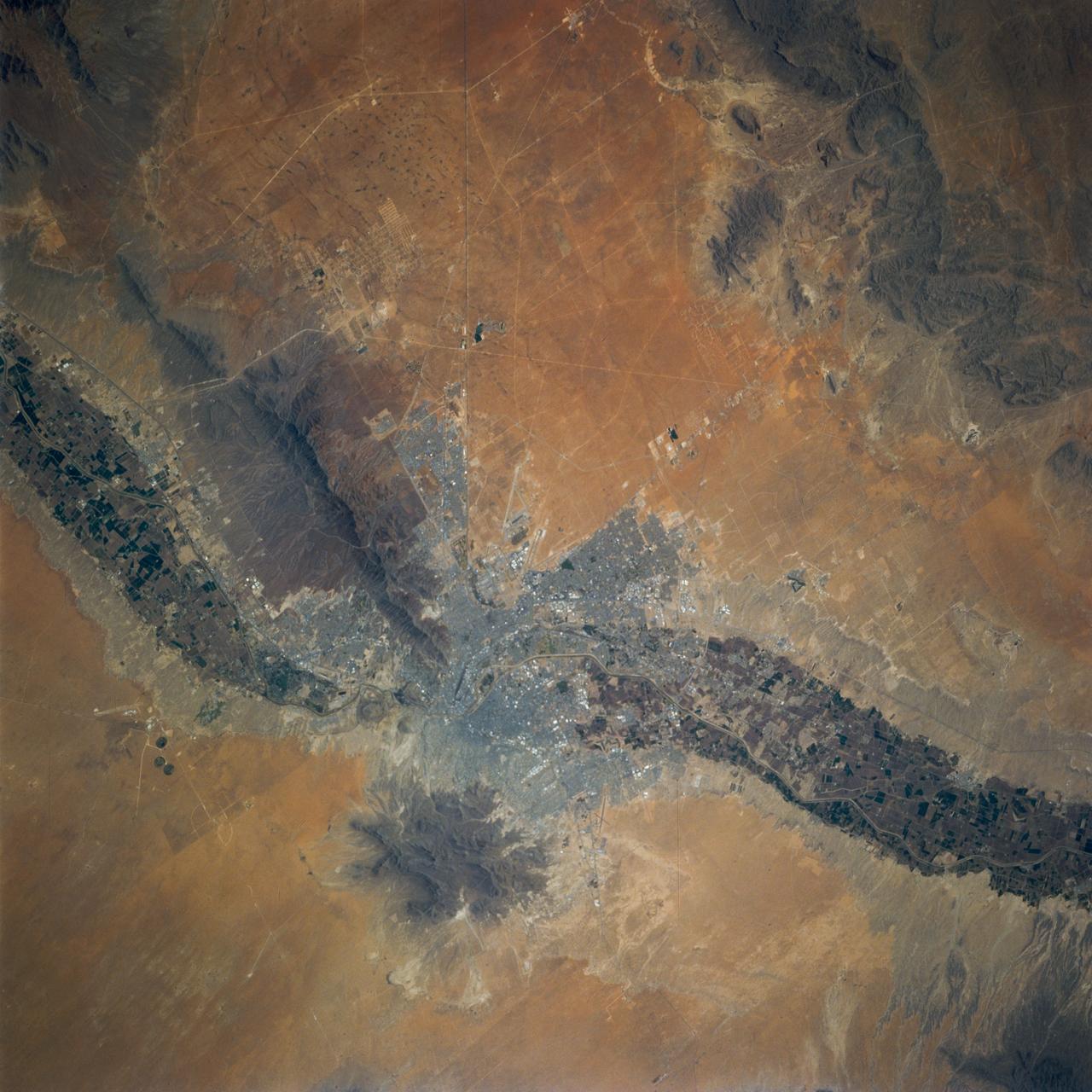
STS077-707-097 (19-29 May 1996) --- This 70mm photograph shows the contrasts between the Chihuahua Desert and the irrigated bottomlands of the Rio Grande. The twin cities of Juarez, Mexico, and El Paso, Texas, on opposite sides of the border are in the center of the frame. The area was first colonized in 1598 making it one of the oldest settlements of Europeans on the North American continent. The name of El Paso derives from the Spanish ?El Paso del Norte.? The City of El Paso became a United States city in 1873. The pass allows passage through the Rocky Mountains in this region. The extension of the Rockies to the northwest of El Paso is known as the Franklin Mountains. Juarez now has over a million people and El Paso has around 400,000. The economy is driven by the maquiladora industries. Fort Bliss on the United States side is a major employer also. Fort Bliss is the wedge shaped feature in El Paso. The post was first established in 1849 for protection from the Comanches and the last horse Calvary unit was disbanded in 1943.

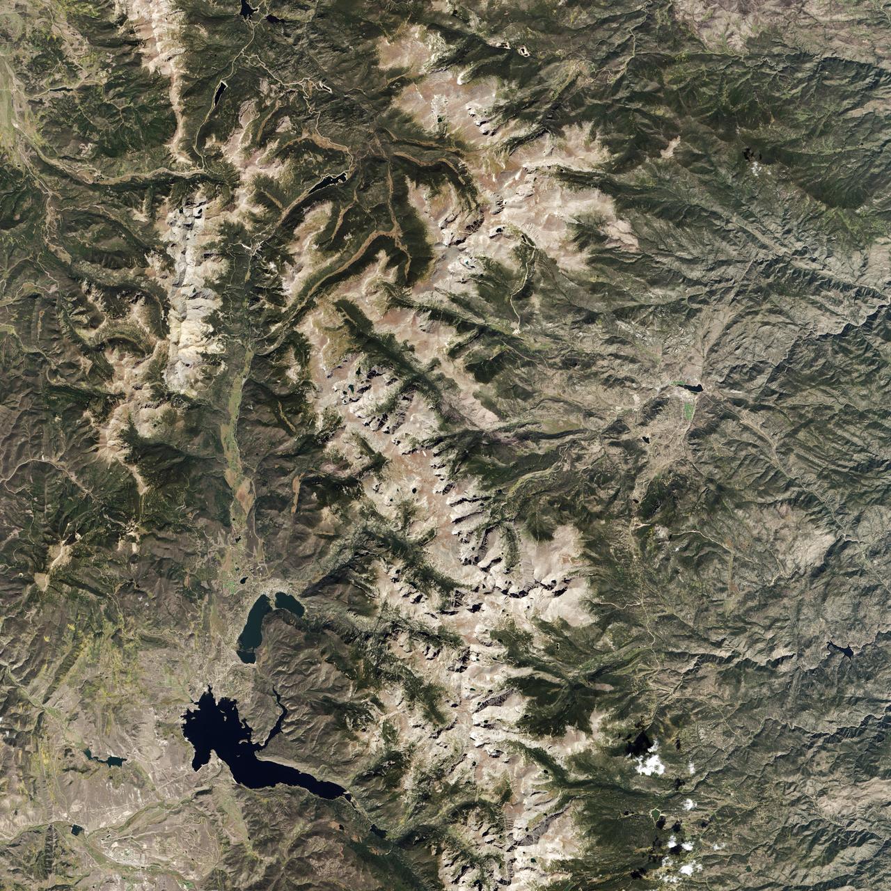
ISS011-E-13889 (30 September 2005) --- Wasatch Range, Utah is featured in this image photographed by an Expedition 11 crewmember on the international space station. The Wasatch Range forms an impressive backdrop to the Salt Lake City metropolitan area, and is a frequent destination for hikers, backpackers, and skiers. The range is considered to be the westernmost part of the Rocky Mountains, and rises to elevations of approximately 3600 meters (12,000 feet) above sea level. This photograph, taken at the end of September, captures red- (maple trees) and gold-mantled (aspen trees) hill slopes along the western mountain front to the south of Salt Lake City. Other common tree species at these elevations include pine, fir, spruce, willow, birch, and oak. A portion of Draper City is visible in the left half of the image. The elevation of Lone Peak, visible at upper right, is approximately 3410 meters (11,253 feet).
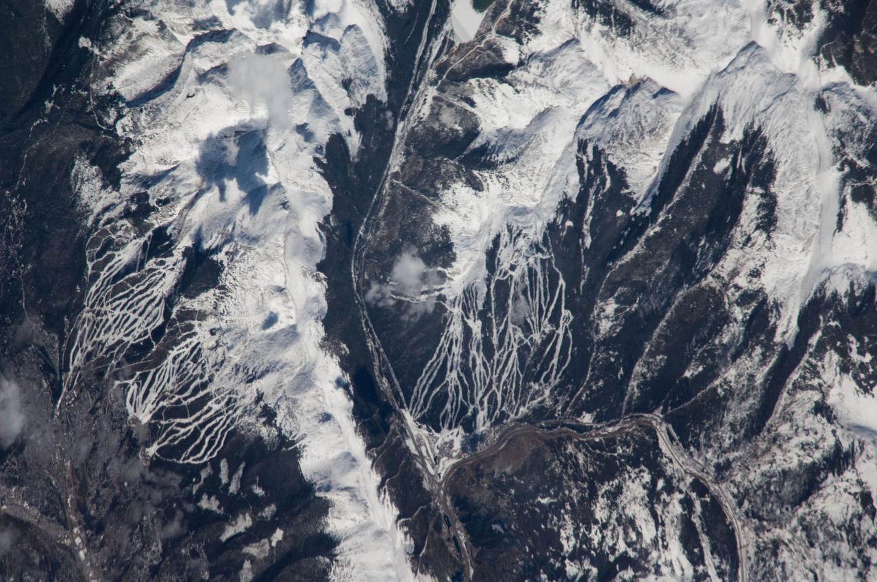
ISS018-E-005353 (24 Oct. 2008) --- Breckenridge and Copper Mountain ski slopes, Colorado are featured in this image photographed by an Expedition 18 crewmember on the International Space Station. Located in a section of the Rocky Mountains which extend through central Colorado, Tenmile Range and Copper Mountain provide the ideal location and landscape for popular winter sports. In this view, the Breckenridge and Copper Mountain ski areas are clearly visible as the snow covered ski runs stand out among the surrounding darker forest. Tenmile Range has mountain peaks that are named Peaks 1 through Peaks 10. The Breckenridge ski area use Peaks 7 through Peaks 10 which range from 12,631 feet (3,850 meters) to 13,615 feet (4,150 meters) high. Tenmile Canyon is a north northeast-trending fault-controlled valley running nearly 3,000 feet (914.4 meters) deep that serves as the boundaries for Tenmile Creek running through the center of the photo. The snow-covered peaks clearly delineate the tree line at an elevation of around 11,000 feet (3,350 meters). In the winter, this area's annual average snowfall ranges between 284 inches (7.21 meters) at Copper Mountain to 300 inches (7.62 meters) a year at Breckenridge. Before recreation became the main industry, miners were attracted to the area in the mid-1800's following discoveries of gold, silver, lead, and zinc. The towns of Breckenridge and Wheeler Junction (at the base of Copper Mountain ski area) were born out of the surge to settle the West during the Pike's Peak Gold Rush. While this image records snow on the peaks of Tenmile Range, the months of October and November 2008 saw little accumulation of snow pack in the area of Breckenridge. The situation changed in early December 2008 however, when more snow fell in eight days than in the preceding two months. The late, but significant, snowfall boosted the snow pack back to expected levels for this time of year.
STS074-714-002 (12-20 Nov 1995) --- The late fall season is tell-tale in this nadir view of Calgary, Alberta, Canada as photographed from the Space Shuttle Atlantis. The ground cover makes it easier to identify geographic and man-made features in the scene. A gateway to the Canadian Rocky Mountains (lower left corner of the photo), Calgary, with a 1994 population listed at 710,677 is noted for its livestock and summer rodeos. It is located on the Bow River, easily traced as it meanders through the city. The Calgary International Airport is easily seen north east of the city.
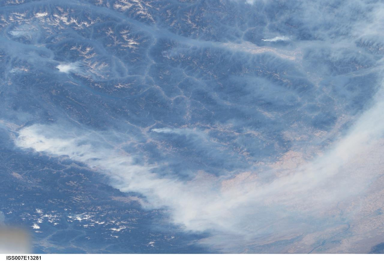
ISS007-E-13281 (20 August 2003) --- This view features forest fires in the Canadian province of British Columbia where some 620,000 acres of forest were consumed in almost 2,500 fires. Here the Rocky Mountains have both lofty, snow-capped peaks and long, narrow valleys that create special conditions and problems with air quality from these smoky fires. This image taken by one of the Expedition 7 crewmembers onboard the International Space Station (ISS) illustrates how smoke has become trapped in valleys where light winds and cold air drainage from the higher elevations have created temperature inversions. Note how the snowy peaks of the mountains are relatively smoke-free while the long, north-south valleys of Kootenay Lake and Columbia River are filled with trapped aerosols from the plumes of the large fires situated in the southwest. Meanwhile shifting winds have now swept the bulk of the plumes southeastward over the Columbia River Basin of Washington.
STS068-247-061 (30 September-11 October 1994) --- Photographed through the Space Shuttle Endeavour's flight windows, this 70mm frame centers on Yellowstone Lake in the Yellowstone National Park. North will be at the top if picture is oriented with series of sun glinted creeks and river branches at top center. The lake, at 2,320 meters (7,732 feet) above sea level, is the largest high altitude lake in North America. East of the park part of the Absaroka Range can be traced by following its north to south line of snow capped peaks. Jackson Lake is southeast of Yellowstone Park, and the connected Snake River can be seen in the lower left corner. Yellowstone, established in 1872 is the world's oldest national park. It covers an area of 9,000 kilometers (3,500 square miles), lying mainly on a broad plateau of the Rocky Mountains on the Continental Divide. It's average altitude is 2,440 meters (8,000 feet) above sea level. The plateau is surrounded by mountains exceeding 3,600 meters (12,000 feet) in height. Most of the plateau was formed from once-molten lava flows, the last of which is said to have occurred 100,000 years ago. Early volcanic activity is still evident in the region by nearly 10,000 hot springs, 200 geysers and numerous vents found throughout the park.

Grinding glaciers and granite peaks mingle in Chile’s Torres del Paine National Park. The Advanced Land Imager (ALI) on NASA’s Earth Observing-1 (EO-1) satellite captured this summertime image of the park on January 21, 2013. This image shows just a portion of the park, including Grey Glacier and the mountain range of Cordillera del Paine. The rivers of glacial ice in Torres del Paine National Park grind over bedrock, turning some of that rock to dust. Many of the glaciers terminate in freshwater lakes, which are rich with glacial flour that colors them brown to turquoise. Skinny rivers connect some of the lakes to each other (image upper and lower right). Cordillera del Paine rises between some of the wide glacial valleys. The compact mountain range is a combination of soaring peaks and small glaciers, most notably the Torres del Paine (Towers of Paine), three closely spaced peaks emblematic of the mountain range and the larger park. By human standards, the mountains of Cordillera del Paine are quite old. But compared to the Rocky Mountains (70 million years old), and the Appalachians (about 480 million years), the Cordillera del Paine are very young—only about 12 million years old. A study published in 2008 described how scientists used zircon crystals to estimate the age of Cordillera del Paine. The authors concluded that the mountain range was built in three pulses, creating a granite laccolith, or dome-shaped feature, more than 2,000 meters (7,000 feet) thick. NASA Earth Observatory image created by Jesse Allen and Robert Simmon, using Advanced Land Imager data from the NASA EO-1 team. Caption by Michon Scott. Instrument: EO-1 - ALI View more info: <a href="http://earthobservatory.nasa.gov/IOTD/view.php?id=80266" rel="nofollow">earthobservatory.nasa.gov/IOTD/view.php?id=80266</a> Credit: <b><a href="http://www.earthobservatory.nasa.gov/" rel="nofollow"> NASA Earth Observatory</a></b> <b><a href="http://www.nasa.gov/audience/formedia/features/MP_Photo_Guidelines.html" rel="nofollow">NASA image use policy.</a></b> <b><a href="http://www.nasa.gov/centers/goddard/home/index.html" rel="nofollow">NASA Goddard Space Flight Center</a></b> enables NASA’s mission through four scientific endeavors: Earth Science, Heliophysics, Solar System Exploration, and Astrophysics. Goddard plays a leading role in NASA’s accomplishments by contributing compelling scientific knowledge to advance the Agency’s mission. <b>Follow us on <a href="http://twitter.com/NASA_GoddardPix" rel="nofollow">Twitter</a></b> <b>Like us on <a href="http://www.facebook.com/pages/Greenbelt-MD/NASA-Goddard/395013845897?ref=tsd" rel="nofollow">Facebook</a></b> <b>Find us on <a href="http://instagrid.me/nasagoddard/?vm=grid" rel="nofollow">Instagram</a></b>
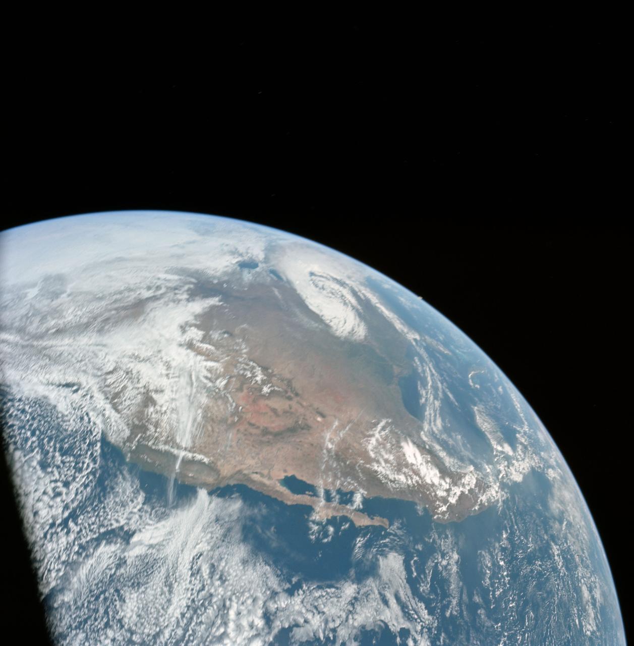
AS16-118-18873 (16 April 1972) --- A good view of Earth photographed shortly after trans-lunar injection of April 16, 1972. Although there is much cloud cover (over Canada and the oceans), the United States in large part, most of Mexico and some parts of Central America are clearly visible. Note Lake Michigan and Lake Superior, also note the Bahama Banks at upper right part of the sphere. A large part of the Rocky Mountain Range is also visible. Just beginning man's fifth lunar landing mission were astronauts John W. Young, commander; Thomas K. Mattingly II, command module pilot; and Charles M. Duke Jr., lunar module pilot. While astronauts Young and Duke descended in the Lunar Module (LM) to explore the moon, astronaut Mattingly remained with the Command and Service Modules (CSM) in lunar orbit.
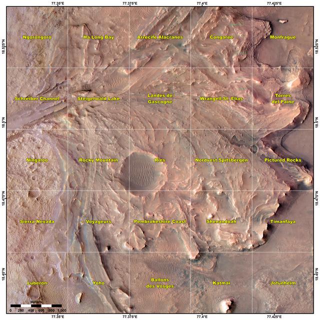
This map shows various quadrant themes in the vicinity of NASA's Perseverance Mars rover, which is currently in the Rocky Mountain quadrant within the much broader Jezero Crater. Each quadrant is 0.7 miles (1.2 kilometers) on each side. The Perseverance team chose quadrant themes related to various national parks across Earth, from Shenandoah National Park in Virginia to Jotunheimen National Park in Norway. The themes help organize the unofficial nicknames that are given by rover team members to different surface features they want to study, such as hills, craters, boulders, and even specific rock surfaces. The first sedimentary rock core sample the rover took was from a rock nicknamed "Skinner Ridge" for a ridge in Shenandoah National Park when Perseverance was in that quadrant. Many hundreds of names are compiled into a list based on each theme and are applied as the rover explores that quadrant. Rovers can sometimes end up exploring a quadrant for months, exhausting the list of names and prompting a new list to be drawn up. A key objective for Perseverance's mission on Mars is astrobiology, including the search for signs of ancient microbial life. The rover will characterize the planet's geology and past climate, pave the way for human exploration of the Red Planet, and be the first mission to collect and cache Martian rock and regolith (broken rock and dust). Subsequent NASA missions, in cooperation with ESA (European Space Agency), would send spacecraft to Mars to collect these sealed samples from the surface and return them to Earth for in-depth analysis. The Mars 2020 Perseverance mission is part of NASA's Moon to Mars exploration approach, which includes Artemis missions to the Moon that will help prepare for human exploration of the Red Planet. https://photojournal.jpl.nasa.gov/catalog/PIA25913
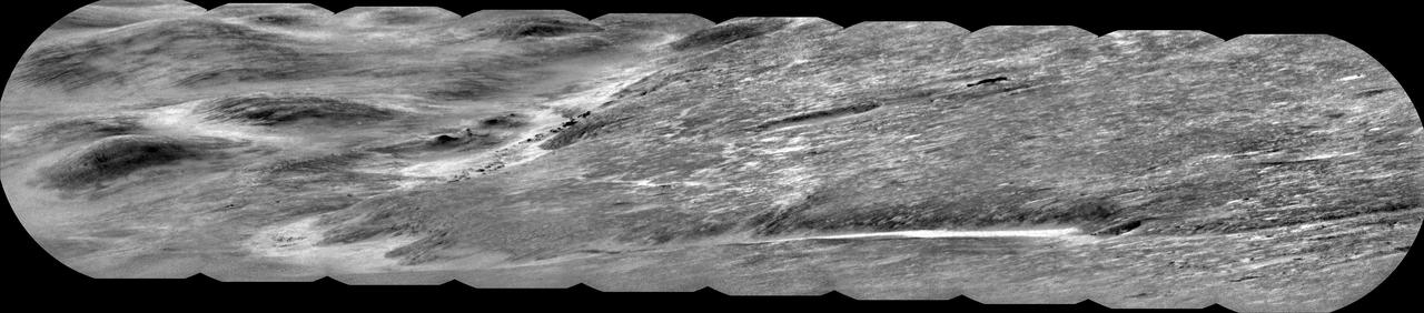
NASA's Curiosity Mars rover used its ChemCam instrument to capture Peace Vallis, an ancient river channel descending Gale Crater's rim, on Sept. 1, 2025 (the 4,647th Martian day, or sol, of the mission). The channel was about 19 miles (30 kilometers) from Curiosity as it explores the foothills of Mount Sharp, a 3-mile-tall (5-kilometer-tall) mountain. The dark features scattered just left of center within the channel are rocky outcrops. While Curiosity has taken pictures of Peace Vallis in the past, this is the first time details like these have been seen within it. Water and sediment are believed to have flowed down Peace Vallis into Gale Crater billions of years ago, creating a fan of sediment across the crater floor. Studying the crater's watery past is part of Curiosity's overall mission to understand where and how well the ancient Martian landscape could have supported microbial life, if any ever formed there. ChemCam is equipped with the Remote Micro Imager, or RMI, a black-and-white camera that can be used like a small telescope to see distant features, creating a circular "spyglass" image. Ten RMI images were stitched together on Earth into a mosaic to create the panorama seen here. https://photojournal.jpl.nasa.gov/catalog/PIA26637
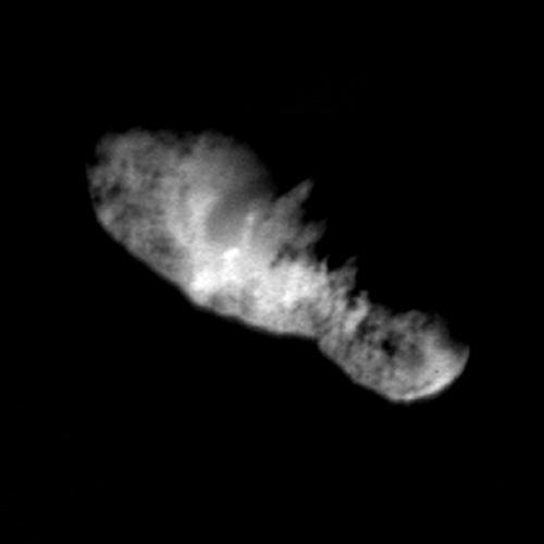
In this highest resolution view of the icy, rocky nucleus of comet Borrelly, (about 45 meters or 150 feet per pixel) a variety of terrains and surface textures, mountains and fault structures, and darkened material are visible over the nucleus's surface. This was the final image of the nucleus of comet Borrelly, taken just 160 seconds before Deep Space1's closest approach to it. This image shows the 8-km (5-mile) long nucleus about 3417 kilometers (over 2,000 miles) away. Smooth, rolling plains containing brighter regions are present in the middle of the nucleus and seem to be the source of dust jets seen in the coma. The rugged land found at both ends of the nucleus has many high ridges along the jagged line between day and night on the comet. This rough terrain contains very dark patches that appear to be elevated compared to surrounding areas. In some places the dark material accentuates grooves and apparent faults. Stereo analysis shows the smaller end of the nucleus (lower right) is tipped toward the viewer (out of frame). Sunlight is coming from the bottom of the frame. http://photojournal.jpl.nasa.gov/catalog/PIA03500
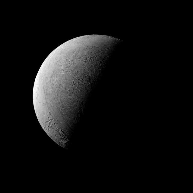
This half-lit view of Enceladus bears a passing resemblance to similar views of Earth's own natural satellite, but the similarities end there. Earth's rocky moon is covered in dark, volcanic basins and brighter, mountainous highlands -- both exceedingly ancient. The surface of icy Enceladus is uniformly bright, far brighter than Earth's moon. Large areas of Enceladus' surface are characterized by youthful (on geologic timescales), wrinkled terrains. Although the north pole of Enceladus (313 miles or 504 kilometers across) was dark when Cassini arrived at Saturn, the march of the seasons at Saturn have brought sunlight to the north and taken it from the south. This view looks toward the leading hemisphere of Enceladus. North on Encealdus is up. The image was taken in visible light with the Cassini spacecraft narrow-angle camera on Sept. 8, 2015. The view was acquired at a distance of approximately 80,000 miles (129,000 kilometers) from Enceladus. Image scale is 2,530 feet (772 meters) per pixel. http://photojournal.jpl.nasa.gov/catalog/PIA18351
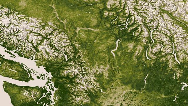
The Rocky, Cascade, and Coast Mountain Ranges dominate the landscape of the Pacific Northwest in this image created June 11-17, 2012 from the Visible-Infrared Imager/Radiometer Suite (VIIRS) instrument aboard the Suomi National Polar-orbiting Partnership or Suomi NPP satellite, a partnership between NASA and the National Oceanic and Atmospheric Administration, or NOAA. Potato and other agriculture can be seen in the bottom center of the image, as the Rockies transition to the plains of Idaho. High values of Normalized Difference Vegetation Index, or NDVI, represent dense green functioning vegetation and low NDVI values represent sparse green vegetation or vegetation under stress from limiting conditions, such as drought. Credit: NASA/NOAA To read more go to: <a href="http://www.nasa.gov/mission_pages/NPP/news/vegetation.html" rel="nofollow">www.nasa.gov/mission_pages/NPP/news/vegetation.html</a> <b><a href="http://www.nasa.gov/audience/formedia/features/MP_Photo_Guidelines.html" rel="nofollow">NASA image use policy.</a></b> <b><a href="http://www.nasa.gov/centers/goddard/home/index.html" rel="nofollow">NASA Goddard Space Flight Center</a></b> enables NASA’s mission through four scientific endeavors: Earth Science, Heliophysics, Solar System Exploration, and Astrophysics. Goddard plays a leading role in NASA’s accomplishments by contributing compelling scientific knowledge to advance the Agency’s mission. <b>Follow us on <a href="http://twitter.com/NASA_GoddardPix" rel="nofollow">Twitter</a></b> <b>Like us on <a href="http://www.facebook.com/pages/Greenbelt-MD/NASA-Goddard/395013845897?ref=tsd" rel="nofollow">Facebook</a></b> <b>Find us on <a href="http://instagram.com/nasagoddard?vm=grid" rel="nofollow">Instagram</a></b>
On July 3, 1936, President Franklin Delano Roosevelt stood amidst the crowd in Big Meadows and officially dedicated Shenandoah National Park in Virginia. The Thematic Mapper on the Landsat satellite captured this view of the heart of Shenandoah National Park on October 10, 2010, at the height of the fall “leaf-peeping” season. The orange and brown swath across the image highlights the hilly backbone of the park, where leaves had turned to their fall colors. The 169-kilometer (105-mile) Skyline Drive that meanders across the crest of the ridge is often jammed with tourists in autumn. The park includes more than 518 miles of hiking trails, including more than 100 miles of the Appalachian Trail. The highest peak is Hawksbill Mountain at 4,051 feet (1,235 m), but the most popular with hikers is Old Rag Mountain. A circuitous eight-mile (13 kilometer) trail leads to an exposed, rocky summit 3,291 feet (1,003 meters) above sea level. The 2,200 foot elevation change from base to summit, combined with several rock scrambles, make Old Rag not only the most popular but also the most dangerous hike. Read more: <a href="http://go.nasa.gov/2bRnFxH" rel="nofollow">go.nasa.gov/2bRnFxH</a> Credit: NASA/Landsat5 <b><a href="http://www.nasa.gov/audience/formedia/features/MP_Photo_Guidelines.html" rel="nofollow">NASA image use policy.</a></b> <b><a href="http://www.nasa.gov/centers/goddard/home/index.html" rel="nofollow">NASA Goddard Space Flight Center</a></b> enables NASA’s mission through four scientific endeavors: Earth Science, Heliophysics, Solar System Exploration, and Astrophysics. Goddard plays a leading role in NASA’s accomplishments by contributing compelling scientific knowledge to advance the Agency’s mission. <b>Follow us on <a href="http://twitter.com/NASAGoddardPix" rel="nofollow">Twitter</a></b> <b>Like us on <a href="http://www.facebook.com/pages/Greenbelt-MD/NASA-Goddard/395013845897?ref=tsd" rel="nofollow">Facebook</a></b> <b>Find us on <a href="http://instagrid.me/nasagoddard/?vm=grid" rel="nofollow">Instagram</a></b>

NASA image acquired July 27, 2001 In southwestern Jordan lies an unusual landscape. Mountains of granite and sandstone rise next to valleys filled with red sand. Some of the mountains reach a height of about 1,700 meters (5,600 feet) above sea level, and many have near-vertical slopes. So alien is this landscape, it’s nicknamed “Valley of the Moon,” and it has served as the film set for a movie about Mars. Yet nomadic people have lived here for thousands of years. Declared a protected area in 1998, this unearthly landscape is Wadi Rum. The Advanced Land Imager (ALI) on NASA’s Earth Observing-1 (EO-1) satellite captured this natural-color image on July 27, 2001. The scene includes part of Wadi Rum and an adjacent area to the east. East of the protected area, fields with center-pivot irrigation make circles of green and brown (image upper right). As the earth tones throughout the image attest, the area is naturally arid, receiving little annual precipitation and supporting only sparse vegetation. Between rocky peaks, the sandy valleys range in color from beige to brick. Ancient granite rocks dating from the Precambrian underlie younger rocks, and some of these basement rocks have eroded into rugged, steep-sloped mountains. The granite mountains have risen thanks partly to crisscrossing fault lines under the park. Overlying the granite are sandstones from the Cambrian and Ordovician Periods, as well as loose sands. Lawrence of Arabia, who fought in the Arab Revolt of 1917–1918, made frequent references to Wadi Rum in his book The Seven Pillars of Wisdom. Likewise, a prominent feature of the protected area is named after the book. Several popular sites in Wadi Rum bear Lawrence of Arabia’s name, but whether he actually visited those sites is uncertain. To download the full high res go to: <a href="http://earthobservatory.nasa.gov/IOTD/view.php?id=49945" rel="nofollow">earthobservatory.nasa.gov/IOTD/view.php?id=49945</a> NASA Earth Observatory image created by Jesse Allen and Robert Simmon, using EO-1 ALI data provided courtesy of the NASA EO-1 team and the United States Geological Survey. Caption by Michon Scott. Instrument: EO-1 - ALI Credit: <b><a href="http://www.earthobservatory.nasa.gov/" rel="nofollow"> NASA Earth Observatory</a></b> <b><a href="http://www.nasa.gov/centers/goddard/home/index.html" rel="nofollow">NASA Goddard Space Flight Center</a></b> enables NASA’s mission through four scientific endeavors: Earth Science, Heliophysics, Solar System Exploration, and Astrophysics. Goddard plays a leading role in NASA’s accomplishments by contributing compelling scientific knowledge to advance the Agency’s mission. <b>Follow us on <a href="http://twitter.com/NASA_GoddardPix" rel="nofollow">Twitter</a></b> <b>Join us on <a href="http://www.facebook.com/pages/Greenbelt-MD/NASA-Goddard/395013845897?ref=tsd" rel="nofollow">Facebook</a></b>
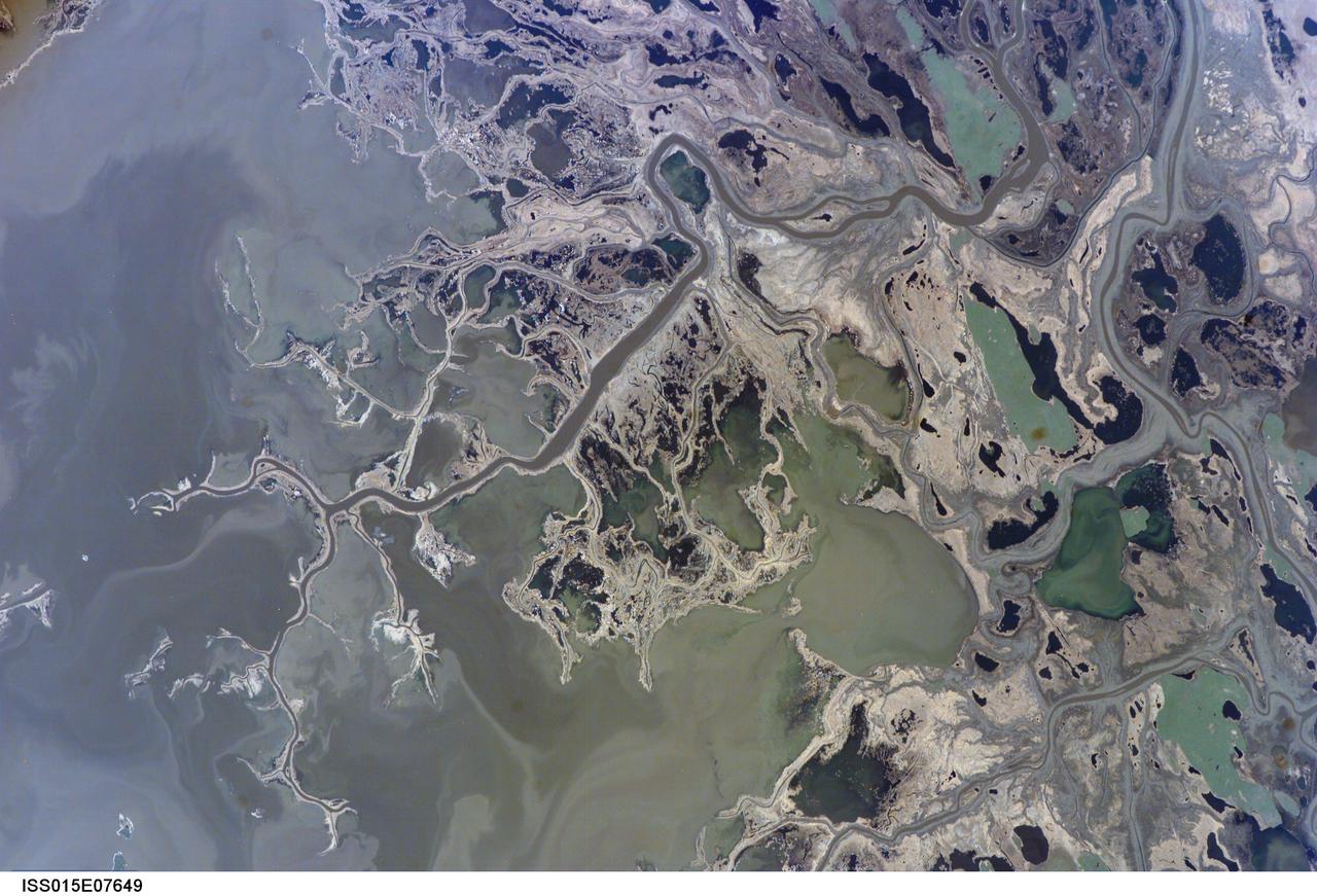
ISS015-E-07649 (11 May 2007) --- Saskatchewan River Delta, Manitoba, Canada is featured in this image photographed by an Expedition 15 crewmember on the International Space Station. This image highlights a portion of the Saskatchewan River delta extending into Cedar Lake in the Province of Manitoba. The Saskatchewan River watershed extends from the Rocky Mountains of Alberta through the plains of Saskatchewan and Manitoba. The construction of the Grand Rapids Dam to the southeast (not shown) in the 1960s flooded the Cedar Lake basin. This has resulted in the formation of numerous shallow, muddy lakes and bogs (dark green to dark grey irregular areas and at upper right) in and around the Saskatchewan River delta. The level of saturation in these bogs is such that peat (semiconsolidated plant and organic matter) deposits have formed; over long periods of time and under the right geological conditions, such deposits can become coal. The velocity of Saskatchewan River water slows significantly as it enters Cedar Lake; as the flow velocity drops, entrained sediment comprised of silt, clay, sand, and gravel is deposited at the river mouth. These deposits, called alluvium by geologists, account for much of the light tan to grey materials bordering the active channels visible in the image (Saskatchewan River, Summerberry River). According to scientists, fossil-bearing amber -- originating from Late Cretaceous (approximately 65-99 million years ago) coal deposits over a thousand kilometers to the west of Cedar Lake -- is also found in the deltaic sediments. As the deposits accumulate, old channels are abandoned and new channels are formed, as the river seeks more favorable flow paths into the lake, this process (known as avulsion) builds out the river delta over time. A typical "birds foot" delta form is currently being constructed at the mouth of the Saskatchewan River (lower left). The birds foot structure is approximately 13 kilometers wide. The Mississippi River's active delta, while having the same general form, is much larger by comparison -- it is approximately 50 kilometers wide.

Mark Pestana is a research pilot and project manager at the NASA Dryden Flight Research Center, Edwards, Calif. He is a pilot for the Beech B200 King Air, the T-34C and the Predator B. He flies the F-18 Hornet as a co-pilot and flight test engineer. Pestana has accumulated more than 4,000 hours of military and civilian flight experience. He was also a flight engineer on the NASA DC-8 flying laboratory. Pestana was the project manager and pilot for the Hi–rate Wireless Airborne Network Demonstration flown on the NASA B200 research aircraft. He flew B200 research missions for the X-38 Space Integrated Inertial Navigation Global Positioning System experiment. Pestana also participated in several deployments of the DC-8, including Earth science expeditions ranging from hurricane research over the Caribbean Sea to ozone studies over the North Pole, atmospheric chemistry over the South Pacific, rain forest health in Central America, Rocky Mountain ice pack assessment, and volcanic and tectonic activity around the Pacific Rim. He came to Dryden as a DC-8 mission manager in June 1998 from NASA Johnson Space Center, Houston, where he served as the Earth and Space Science discipline manager for the International Space Station Program at Johnson. Pestana also served as a flight crew operations engineer in the Astronaut Office, developing the controls, displays, tools, crew accommodations and procedures for on-orbit assembly, test, and checkout of the International Space Station. He led the analysis and technical negotiations for modification of the Russian Soyuz spacecraft as an emergency crew return vehicle for space station crews. He joined the U.S. Air Force Reserve in 1991 and held various positions as a research and development engineer, intelligence analyst, and Delta II launch vehicle systems engineer. He retired from the U.S. Air Force Reserve with the rank of colonel in 2005. Prior to 1990, Pestana was on active duty with the U.S. Air Force as the director of mi

ISS038-E-023651 (26 Dec. 2013) --- Lake Sharpe near Lower Brule, South Dakota is featured in this image photographed by an Expedition 38 crew member on the International Space Station. The Missouri River rises in the Rocky Mountains of western Montana, and flows generally to the southeast for approximately 3,767 kilometers (2,341 miles) to its confluence with the Mississippi River north of St. Louis, Missouri -- making it the longest river in North America. The river does not follow a straight southeasterly course along this distance, but includes may meander bends such as illustrated in this photograph. This particular bend is occupied by Lake Sharpe, an approximately 130-kilometer (80 miles) long reservoir formed behind the Big Bend Dam on the Missouri River. The lake surface is frozen and covered with snow, presenting a uniform white appearance in the image. As meander bends develop, they tend to assume a distinctive U-shape when viewed from above. Over time, the river channel can continue to cut into the ends of the "U", eventually bringing them so close together that the river then cuts across the gap to achieve a shorter flow path, essentially short-circuiting or cutting off the meander bend. When this happens and the meander ceases to be part of the active river channel, it may become an oxbow lake. The distance across the narrow neck of land (lower right) associated with this meander near Lower Brule, South Dakota is approximately one kilometer (0.62 miles); however, as the river flow is controlled by the Big Bend Dam downstream, the natural process of meander cutoff has been significantly slowed. The snow cover also highlights circular agricultural fields on the small peninsula within the meander bend. This type of field indicates center-pivot irrigation, where water is distributed from a central point radially outwards using sprinklers to cover the field area. Crops grown here include corn and soybeans according to data from the US Department of Agriculture's CropScape database.
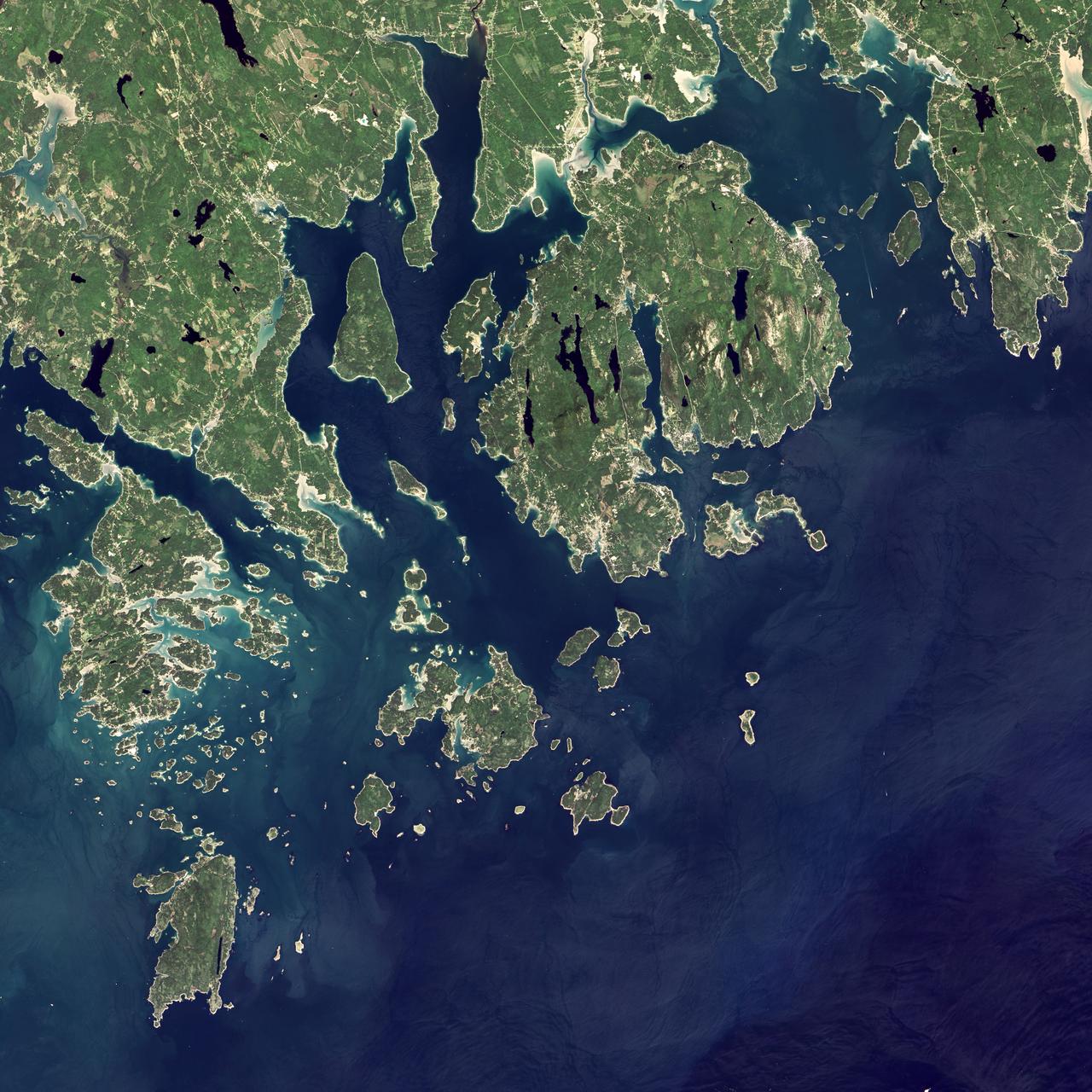
Acadia National Park is one of the most visited parks in America, drawing more than 2.5 million visitors per year to the craggy, jagged coast of Maine. The park is celebrating its 100th anniversary in 2016. On September 6, 2015, the Operational Land Imager (OLI) on the Landsat 8 satellite acquired these images of Acadia National Park and its surroundings. Mountains and hills roll right up to the Atlantic Ocean in this rocky landscape carved by glaciers at the end of the last Ice Age. Since the beginning of the 20th Century, the park has been pieced together by donations and acquisitions of once-private lands, and it is still growing. Of the park’s 47,000 acres, more than 12,000 are privately owned lands under conservation agreements, while the rest is held by the National Park Service. Mount Desert Island is the focal point of the park, which also includes lands around a former naval base (Schoodic Peninsula), Isle au Haut, and several smaller islands. Read more: <a href="http://go.nasa.gov/2adyd8J" rel="nofollow">go.nasa.gov/2adyd8J</a> Credit: NASA/Landsat8 <b><a href="http://www.nasa.gov/audience/formedia/features/MP_Photo_Guidelines.html" rel="nofollow">NASA image use policy.</a></b> <b><a href="http://www.nasa.gov/centers/goddard/home/index.html" rel="nofollow">NASA Goddard Space Flight Center</a></b> enables NASA’s mission through four scientific endeavors: Earth Science, Heliophysics, Solar System Exploration, and Astrophysics. Goddard plays a leading role in NASA’s accomplishments by contributing compelling scientific knowledge to advance the Agency’s mission. <b>Follow us on <a href="http://twitter.com/NASAGoddardPix" rel="nofollow">Twitter</a></b> <b>Like us on <a href="http://www.facebook.com/pages/Greenbelt-MD/NASA-Goddard/395013845897?ref=tsd" rel="nofollow">Facebook</a></b> <b>Find us on <a href="http://instagrid.me/nasagoddard/?vm=grid" rel="nofollow">Instagram</a></b>
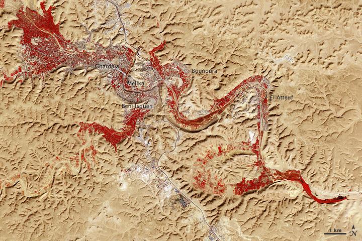
NASA image acquired Feb. 9, 2011 Less than 5 percent of Algeria’s land surface is suitable for growing crops, and most precipitation falls on the Atlas Mountains along the coast. Inland, dust-laden winds blow over rocky plains and sand seas. However, in north central Algeria—off the tip of Grand Erg Occidental and about 450 kilometers (280 miles) south of Algiers—lies a serpentine stretch of vegetation. It is the M’zab Valley, filled with palm groves and dotted with centuries-old settlements. The Advanced Spaceborne Thermal Emission and Reflection Radiometer (ASTER) on NASA’s Terra satellite captured this image of M’zab Valley on February 9, 2011. ASTER combines infrared, red, and green wavelengths of light. Bare rock ranges in color from beige to peach. Buildings and paved surfaces appear gray. Vegetation is red, and brighter shades of red indicate more robust vegetation. This oasis results from water that is otherwise in short supply in the Sahara Desert, thanks to the valley’s approximately 3,000 wells. Chemical analysis of Algerian aquifers, as well studies of topography in Algeria and Tunisia, suggest this region experienced a cooler climate in the late Pleistocene, and potentially heavy monsoon rains earlier in the Holocene. The M’zab region shows evidence of meandering rivers and pinnate drainage patterns. The vegetation lining M’zab Valley highlights this old river valley’s contours. Cool summer temperatures and monsoon rains had long since retreated from the region by eleventh century, but this valley nevertheless supported the establishment of multiple fortified settlements, or ksours. Between 1012 A.D. and 1350 A.D., locals established the ksours of El-Atteuf, Bounoura, Melika, Ghardaïa, and Beni-Isguen. Collectively these cities are now a United Nations Educational, Scientific, and Cultural Organization (UNESCO) World Heritage site. NASA Earth Observatory image by Robert Simmon and Jesse Allen, using data from the GSFC/METI/ERSDAC/JAROS, and U.S./Japan ASTER Science Team. Caption by Michon Scott. Instrument: Terra - ASTER <b>To download the full high res file go <a href="http://earthobservatory.nasa.gov/IOTD/view.php?id=51296" rel="nofollow"> here</a></b>
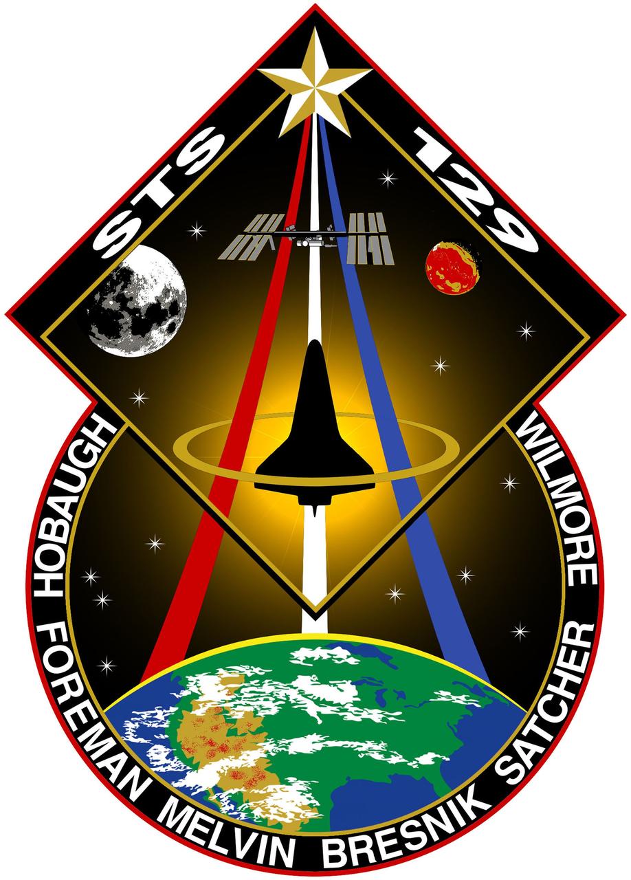
JOHNSON SPACE CENTER, Houston - STS129-S-001 -- For STS-129 the sun shines brightly on the International Space Station (ISS) above and the United States below representing the bright future of U.S. human spaceflight. The contiguous U.S., Rocky Mountains, and Great Desert Southwest are clearly visible on the earth below encompassing all the NASA centers and the homes of the many dedicated people that work to make our Space Program possible. The integrated shapes of the patch signifying the two Express Logistics Carriers that will be delivered by STS-129 providing valuable equipment ensuring the longevity of the ISS. The Space Shuttle is vividly silhouetted by the sun highlighting how brightly the Orbiters have performed as a workhorse for the U.S. Space Program over the past 3 decades. The Space Shuttle ascends on the Astronaut symbol portrayed by the Red, White and Blue swoosh bounded by the gold halo. This symbol is worn with pride by this U.S. crew representing their country on STS-129. The names of the crew members are denoted on the outer band of the patch. As STS-129 launches, the Space Shuttle is in its twilight years. This fact is juxtaposed by the 13 stars on the patch which are symbolic of our children who are the future. The Moon and Mars feature predominantly to represent just how close humankind is to reaching further exploration of those heavenly bodies and how the current Space Shuttle and ISS missions are laying the essential ground work for those future endeavors. The NASA insignia for design for Shuttle flights is reserved for use by the astronauts and for other official use as the NASA Administrator may authorize. Public availability has been approved only in the form of illustrations by the various news media. When and if there is any change in this policy which is not anticipated, it will be publicly announced. (Note: the description is provided by the crew members).
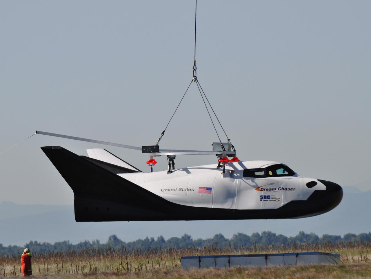
LOUISVILLE, Colo. – Sierra Nevada Corporation Space Systems’ Dream Chaser full-scale test vehicle is lifted by an Erickson Air-Crane helicopter to verify proper aerodynamic flight performance near the Rocky Mountain Metropolitan Airport in Jefferson County, Colo. This captive-carry test is one of several milestones the company is meeting during its partnership with NASA’s Commercial Crew Program CCP. Data from this test will provide SNC an early opportunity to evaluate and prove hardware, facilities and ground operations in preparation for approach and landing tests scheduled for later this year. In 2011, NASA selected Sierra Nevada during Commercial Crew Development Round 2 CCDev2) activities to mature the design and development of a crew transportation system with the overall goal of accelerating a United States-led capability to the International Space Station. The goal of CCP is to drive down the cost of space travel as well as open up space to more people than ever before by balancing industry’s own innovative capabilities with NASA's 50 years of human spaceflight experience. Six other aerospace companies also are maturing launch vehicle and spacecraft designs under CCDev2, including Alliant Techsystems Inc. ATK, The Boeing Co., Excalibur Almaz Inc., Blue Origin, Space Exploration Technologies SpaceX, and United Launch Alliance ULA. For more information, visit www.nasa.gov/commercialcrew. Image credit: Sierra Nevada Corp.
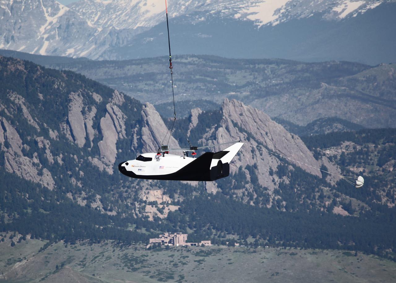
LOUISVILLE, Colo. – Sierra Nevada Corporation Space Systems’ Dream Chaser full-scale test vehicle is lifted by an Erickson Air-Crane helicopter to verify proper aerodynamic flight performance near the Rocky Mountain Metropolitan Airport in Jefferson County, Colo. This captive-carry test is one of several milestones the company is meeting during its partnership with NASA’s Commercial Crew Program CCP. Data from this test will provide SNC an early opportunity to evaluate and prove hardware, facilities and ground operations in preparation for approach and landing tests scheduled for later this year. In 2011, NASA selected Sierra Nevada during Commercial Crew Development Round 2 CCDev2) activities to mature the design and development of a crew transportation system with the overall goal of accelerating a United States-led capability to the International Space Station. The goal of CCP is to drive down the cost of space travel as well as open up space to more people than ever before by balancing industry’s own innovative capabilities with NASA's 50 years of human spaceflight experience. Six other aerospace companies also are maturing launch vehicle and spacecraft designs under CCDev2, including Alliant Techsystems Inc. ATK, The Boeing Co., Excalibur Almaz Inc., Blue Origin, Space Exploration Technologies SpaceX, and United Launch Alliance ULA. For more information, visit www.nasa.gov/commercialcrew. Image credit: Sierra Nevada Corp.
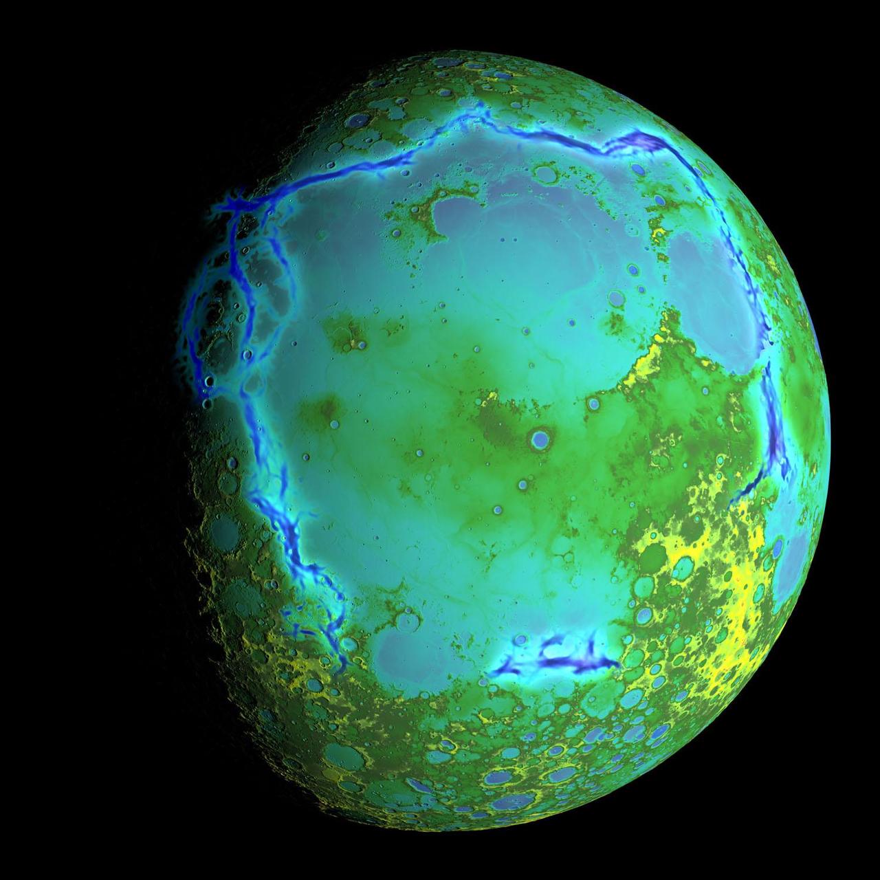
Topography of Earth's moon generated from data collected by the Lunar Orbiter Laser Altimeter, aboard NASA's Lunar Reconnaissance Orbiter, with the gravity anomalies bordering the Procellarum region superimposed in blue. The border structures are shown using gravity gradients calculated with data from NASA's Gravity Recovery and Interior Laboratory (GRAIL) mission. These gravity anomalies are interpreted as ancient lava-flooded rift zones buried beneath the volcanic plains (or maria) on the nearside of the Moon. Launched as GRAIL A and GRAIL B in September 2011, the probes, renamed Ebb and Flow, operated in a nearly circular orbit near the poles of the moon at an altitude of about 34 miles (55 kilometers) until their mission ended in December 2012. The distance between the twin probes changed slightly as they flew over areas of greater and lesser gravity caused by visible features, such as mountains and craters, and by masses hidden beneath the lunar surface. The twin spacecraft flew in a nearly circular orbit until the end of the mission on Dec. 17, 2012, when the probes intentionally were sent into the moon's surface. NASA later named the impact site in honor of late astronaut Sally K. Ride, who was America's first woman in space and a member of the GRAIL mission team. GRAIL's prime and extended science missions generated the highest-resolution gravity field map of any celestial body. The map will provide a better understanding of how Earth and other rocky planets in the solar system formed and evolved. The GRAIL mission was managed by NASA's Jet Propulsion Laboratory (JPL) in Pasadena, California, for NASA's Science Mission Directorate in Washington. The mission was part of the Discovery Program managed at NASA's Marshall Space Flight Center in Huntsville, Alabama. GRAIL was built by Lockheed Martin Space Systems in Denver. For more information about GRAIL, please visit <a href="http://grail.nasa.gov" rel="nofollow">grail.nasa.gov</a>. Credit: NASA/Colorado School of Mines/MIT/GSFC/Scientific Visualization Studio
It has to be one of America’s most diverse national park landscapes. If you walked from west to east across Olympic National Park, you would start at the rocky Pacific shoreline, move into rare temperate rainforests and lush river valleys, ascend glaciers and rugged mountain peaks, and then descend into a comparatively dry rain shadow and alpine forest. From the beach to the top of Mount Olympus, you would rise 7,980 feet (2430 meters) above sea level. Situated on the Olympic Peninsula in northwestern Washington, these lands were first set aside as a national monument in 1909 by Theodore Roosevelt. Twenty-nine years later, his cousin Franklin officially established Olympic National Park. International institutions have also made a case for treasuring this land, as the area was declared an International Biosphere Reserve in 1976 and a World Heritage Site in 1981. The park encompasses nearly 923,000 acres of wild lands, including 60 named glaciers, 73 miles of coast, and 3,000 miles of rivers and streams. Read more: <a href="http://go.nasa.gov/2bRmzSJ" rel="nofollow">go.nasa.gov/2bRmzSJ</a> Credit: NASA/Landsat8 <b><a href="http://www.nasa.gov/audience/formedia/features/MP_Photo_Guidelines.html" rel="nofollow">NASA image use policy.</a></b> <b><a href="http://www.nasa.gov/centers/goddard/home/index.html" rel="nofollow">NASA Goddard Space Flight Center</a></b> enables NASA’s mission through four scientific endeavors: Earth Science, Heliophysics, Solar System Exploration, and Astrophysics. Goddard plays a leading role in NASA’s accomplishments by contributing compelling scientific knowledge to advance the Agency’s mission. <b>Follow us on <a href="http://twitter.com/NASAGoddardPix" rel="nofollow">Twitter</a></b> <b>Like us on <a href="http://www.facebook.com/pages/Greenbelt-MD/NASA-Goddard/395013845897?ref=tsd" rel="nofollow">Facebook</a></b> <b>Find us on <a href="http://instagrid.me/nasagoddard/?vm=grid" rel="nofollow">Instagram</a></b>
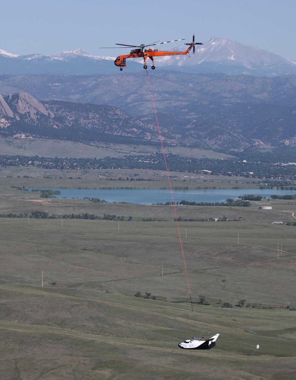
LOUISVILLE, Colo. – An Erickson Air-Crane helicopter lifts Sierra Nevada Corporation Space Systems’ Dream Chaser full-scale test vehicle to verify proper aerodynamic flight performance near the Rocky Mountain Metropolitan Airport in Jefferson County, Colo. This captive-carry test is one of several milestones the company is meeting during its partnership with NASA’s Commercial Crew Program CCP. Data from this test will provide SNC an early opportunity to evaluate and prove hardware, facilities and ground operations in preparation for approach and landing tests scheduled for later this year. In 2011, NASA selected Sierra Nevada during Commercial Crew Development Round 2 CCDev2) activities to mature the design and development of a crew transportation system with the overall goal of accelerating a United States-led capability to the International Space Station. The goal of CCP is to drive down the cost of space travel as well as open up space to more people than ever before by balancing industry’s own innovative capabilities with NASA's 50 years of human spaceflight experience. Six other aerospace companies also are maturing launch vehicle and spacecraft designs under CCDev2, including Alliant Techsystems Inc. ATK, The Boeing Co., Excalibur Almaz Inc., Blue Origin, Space Exploration Technologies SpaceX, and United Launch Alliance ULA. For more information, visit www.nasa.gov/commercialcrew. Image credit: Sierra Nevada Corp.
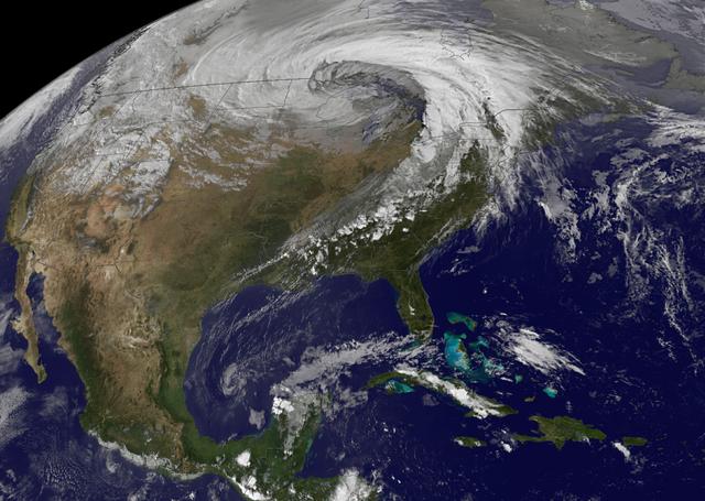
This NOAA's GOES satellite infrared image taken on Nov. 25 at 11:45 UTC (6:45 a.m. EST) shows two main weather systems over the U.S. Credit: NASA/NOAA GOES Project As the U.S. Thanksgiving holiday approaches this Thursday, November 27, NOAA's GOES-East and GOES-West satellites are keeping a weather eye out for storms that may affect early travelers. In an image from Nov. 25, the satellites show an active weather pattern is in place for travelers across the central and eastern U.S. NOAA's GOES-East satellite provides visible and infrared images over the eastern U.S. and the Atlantic Ocean, while NOAA's GOES-West satellite covers the western U.S. and Pacific Ocean from its fixed orbit in space. Data from both satellites were combined at NASA's GOES Project to create a full view of the U.S. on Nov. 25 at 11:45 UTC (6:45 a.m. EST). The image shows clouds associated with cold front stretching from the Gulf of Mexico over northern Florida and along the U.S. East coast to eastern Canada. Clouds associated with another area of low pressure are in the northern Rockies and northwestern U.S. To create the image, NASA/NOAA's GOES Project takes the cloud data from NOAA's GOES-East satellite and overlays it on a true-color image of land and ocean created by data from the Moderate Resolution Imaging Spectroradiometer, or MODIS, instrument that flies aboard NASA's Aqua and Terra satellites. Together, those data created the entire picture of the storm and show its movement. After the storm system passes, the snow on the ground becomes visible. NOAA's National Weather Service Weather Prediction Center said "a storm system will develop off the coast of the Carolinas early Wednesday (Nov. 25) and strengthen as it moves rapidly up the East Coast Wednesday into early Thursday (Nov. 26). Heavy snow is likely to begin in the central Appalachians early Wednesday morning, spreading northeast through the interior Mid-Atlantic into New England by Wednesday night. Winter Storm Watches are in effect for these areas." For travelers in the western U.S., the Northern Rocky Mountains are expected to receive more snow from the north side of a stationary frontal boundary. South of the boundary rain showers will affect the lower valley. The National Weather Service calls for cold weather to continue in the northern Plains and Upper Midwest as a Canadian surface high pressure rules the weather. The U.S. Southwest will experience nice weather for mid-week. In the Pacific Northwest, the National Weather Service noted that a warm front will bring rain, heavy at times, to the Cascades today and tonight. There will be a break in the heavier rains on Wednesday, then another period of heavy rain for the Cascades Wednesday night through Friday morning as a cold front slowly drags through the area. NOAA's GOES satellites provide the kind of continuous monitoring necessary for intensive data analysis. Geostationary describes an orbit in which a satellite is always in the same position with respect to the rotating Earth. This allows GOES to hover continuously over one position on Earth's surface, appearing stationary. As a result, GOES provide a constant vigil for the atmospheric triggers for severe weather conditions such as tornadoes, flash floods, hail storms and hurricanes.
This 60-second video pans across an enhanced-color composite image, or mosaic, of the delta at Jezero Crater on Mars. The delta formed billions of years ago from sediment that an ancient river carried to the mouth of the lake that once existed in the crater. Taken by the Mastcam-Z instrument aboard NASA's Perseverance rover, the video begins looking almost due west of the rover, and sweeps to the right until it faces almost due north. Fourteen images compose the mosaic that provides the base image for this video (included as an additional figure); they were acquired on Nov. 28, 2021 (the 275th sol, or Martian day, of Perseverance's mission) as the rover sat at the highest vantage point in the "South Séítah" geological unit, allowing a perspective that included boulders and other features atop the delta as well as farther west and northwest across its surface. The mountains in the background are the rim of Jezero Crater. The view also shows brown hills in the middle distance that are part of an ancient delta, where a river hit a lake in the crater. The rover has spent the last several months exploring the sandy and rocky terrain in the foreground. The color bands of the image have been processed to improve visual contrast and accentuate color differences. The sky would not actually look blue to a human explorer on the Red Planet. The Mastcam-Z investigation is led and operated by Arizona State University in Tempe, working in collaboration with Malin Space Science Systems in San Diego, California, on the design, fabrication, testing, and operation of the cameras, and in collaboration with the Neils Bohr Institute of the University of Copenhagen on the design, fabrication, and testing of the calibration targets. A key objective for Perseverance's mission on Mars is astrobiology, including the search for signs of ancient microbial life. The rover will characterize the planet's geology and past climate, pave the way for human exploration of the Red Planet, and be the first mission to collect and cache Martian rock and regolith (broken rock and dust). Subsequent NASA missions, in cooperation with ESA (European Space Agency), would send spacecraft to Mars to collect these sealed samples from the surface and return them to Earth for in-depth analysis. The Mars 2020 Perseverance mission is part of NASA's Moon to Mars exploration approach, which includes Artemis missions to the Moon that will help prepare for human exploration of the Red Planet. Movie available at https://photojournal.jpl.nasa.gov/catalog/PIA25022
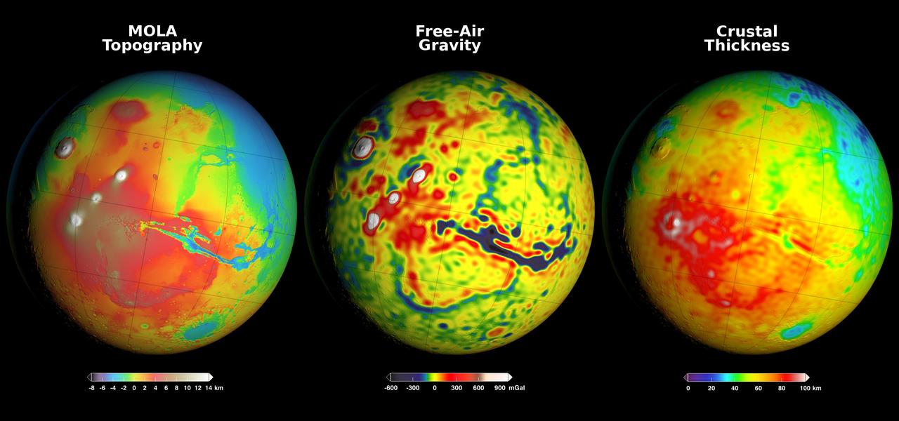
Newly detailed mapping of local variations in Mars' gravitational pull on orbiters (center), combined with topographical mapping of the planet's mountains and valleys (left) yields the best-yet mapping of Mars' crustal thickness (right). These three views of global mapping are centered at 90 degrees west longitude, showing portions of the planet that include tall volcanoes on the left and the deep Valles Marineris canyon system just right of center. Additional views of these global maps are available at http://svs.gsfc.nasa.gov/goto?4436. The new map of Mars' gravity (center) results from analysis of the planet's gravitational effects on orbiters passing over each location on the globe. The data come from many years of using NASA's Deep Space Network to track positions and velocities of NASA's Mars Global Surveyor, Mars Odyssey and Mars Reconnaissance Orbiter. If Mars were a perfectly smooth sphere of uniform density, the gravity experienced by the spacecraft would be exactly the same everywhere. But like other rocky bodies in the solar system, including Earth, Mars has both a bumpy surface and a lumpy interior. As the spacecraft fly in their orbits, they experience slight variations in gravity caused by both of these irregularities, variations which show up as small changes in the velocity and altitude of the three spacecraft. The "free-air" gravity map presents the results without any adjustment for the known bumpiness of Mars' surface. Local gravitational variations in acceleration are expressed in units called gals or galileos. The color-coding key beneath the center map indicates how colors on the map correspond to mGal (milligal) values. The map on the left shows the known bumpiness, or topography, of the Martian surface, using data from the Mars Orbiter Laser Altimeter (MOLA) instrument on Mars Global Surveyor. Mars has no actual "sea level," but does have a defined zero elevation level. The color-coding key beneath this map indicates how the colors correspond to elevations above or below zero, in kilometers. Analysis that subtracts effects of the surface topography from the free-air gravity mapping, combined with an assumption that crust material has a uniform density, leads to the derived mapping of crustal thickness -- or subsurface "lumpiness" -- on the right. Highs in gravity indicate places where the denser mantle material beneath the crust is closer to the surface, and hence where the crust is thinner. The color-coding key for this map indicates how the colors on the map correspond to the thickness of the crust, in kilometers. http://photojournal.jpl.nasa.gov/catalog/PIA20277
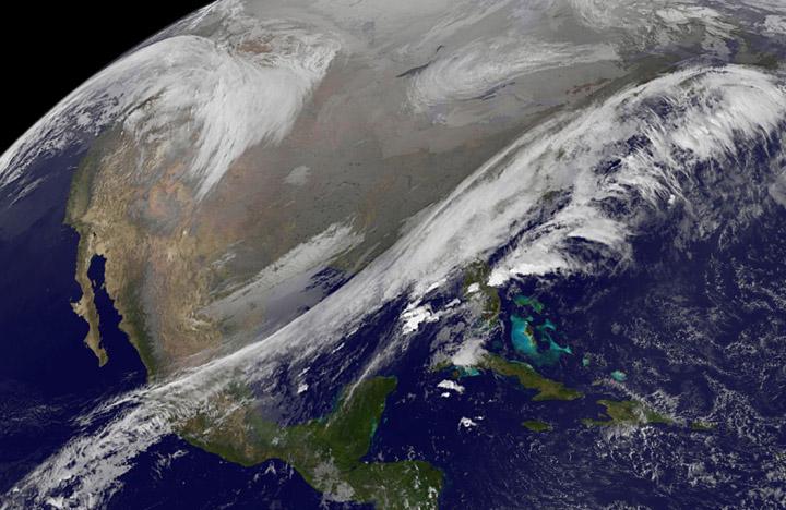
NASA image acquired October 26, 2010 The storm that swept across the center of the United States on October 26 and October 27, 2010, was memorable to those who experienced it because of its strong winds, rain, hail, and widespread tornadoes. Meteorologists get excited about the storm because it set a record for the lowest pressure (not associated with a hurricane) measured over land in the continental United States. At 5:13 p.m. CDT, the weather station in Bigfork, Minnesota recorded 955.2 millibars (28.21 inches of pressure). Pressure is one indicator of a storm’s strength, and this measurement corresponds to the pressure seen in a Category 3 hurricane. This image, taken by the GOES satellite on October 26, shows the storm system circling around the area of extreme low pressure. Such extratropical cyclones form over the United States in the spring and fall, when the temperature difference from north to south is large. Warm, high-pressure air rushes toward the cooler, low-pressure air in the north. Because the Earth is rotating, the air moving in ends up circling the area of low pressure, creating the cyclone shown in the image. The intensity of the storm is determined by the pressure difference between the center and the outer edges. Extreme low pressure in the center of the storm, therefore, is an indicator that the storm was very intense. The animation shows the storm developing starting late on October 25 and running through October 27. The cyclone formed very quickly on October 26, taking a distinctive comma shape as the day went on. The storm developed so quickly, in fact, that it is classified as a bomb, an extremely fast developing storm (dropping at least one millibar of pressure per hour for 24 hours), more common over water than land. The storm was also huge. Though the area of low pressure is centered over the Upper Midwest, the storm reached from the Gulf of Mexico into Canada, and from the Rocky Mountains to the Atlantic Ocean. Extratropical cyclones bring an array of unsettled weather, including strong wind, rain, hail, and tornadoes, and this cyclone brought all of that. On October 26–27, winds gusted up to 78 miles per hour in Michigan, with high winds throughout the Midwest. The National Weather Service reported 61 tornadoes over the two days. Heavy snow also fell in the north. NASA Earth Observatory imagery created by Jesse Allen, using imagery provided courtesy of the NASA GOES Project Science Office. Caption by Holli RIebeek. Instrument: GOES Credit: <b><a href="http://www.earthobservatory.nasa.gov/" rel="nofollow"> NASA Earth Observatory</a></b> <b><a href="http://www.nasa.gov/centers/goddard/home/index.html" rel="nofollow">NASA Goddard Space Flight Center</a></b> enables NASA’s mission through four scientific endeavors: Earth Science, Heliophysics, Solar System Exploration, and Astrophysics. Goddard plays a leading role in NASA’s accomplishments by contributing compelling scientific knowledge to advance the Agency’s mission. <b>Follow us on <a href="http://twitter.com/NASA_GoddardPix" rel="nofollow">Twitter</a></b> <b>Join us on <a href="http://www.facebook.com/pages/Greenbelt-MD/NASA-Goddard/395013845897?ref=tsd" rel="nofollow">Facebook</a></b>
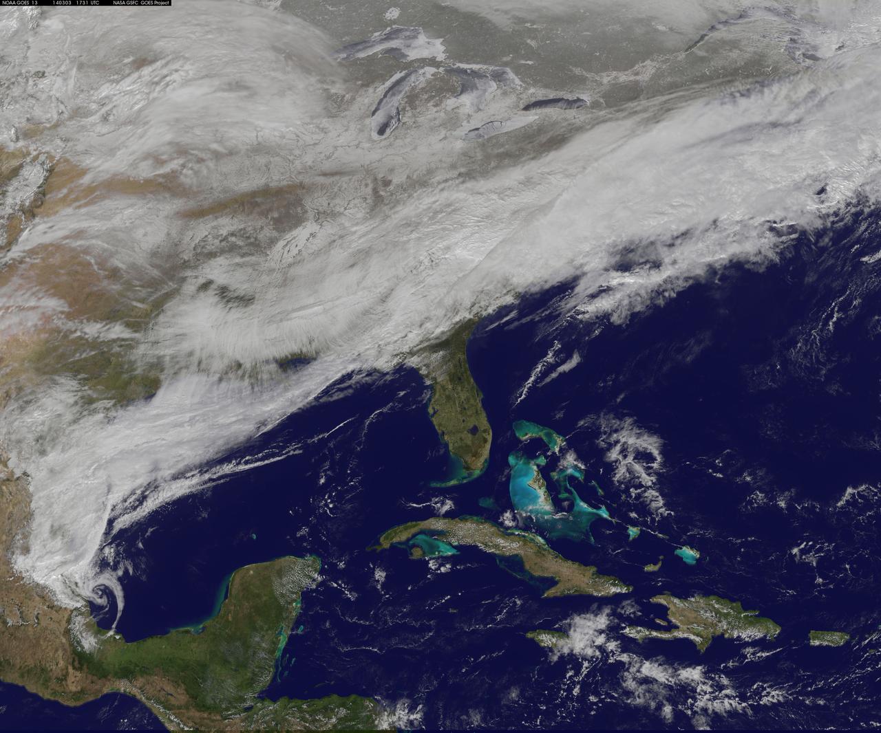
On March 3, a major winter storm brought snow to the mid-Atlantic, freezing rain to the Carolinas and rain and some freezing rain to the Gulf Coast states. NOAA's GOES-East satellite captured an image of the clouds associated with the winter storm on March 3 at 12:45 p.m. EST (1745 UTC)/ as it continued on its march over the mid-Atlantic. Bands of snow and sometimes heavy snow affected the Washington, D.C., region, Delaware and central Virginia, stretching west into West Virginia and eastern Kentucky. Snow also stretched back into the Ohio and Tennessee valleys while rain and freezing rain affected the Carolinas, and while the Gulf Coast states received rain. National Weather Service Winter Storm Warnings remained in effect until 6 p.m. EST on March 3 for Washington, D.C., and Baltimore, Md. In Richmond and Norfolk, Va., the Winter Storm warnings were in effect for six additional hours ending at midnight. On March 3, NOAA's National Weather Prediction Center in College Park, Md., noted the late-season winter storm will continue to shift eastward through the Tennessee Valley and the mid-Atlantic today, making for hazardous travel conditions. NOAA noted that unseasonably cold temperatures more typical of January will prevail east of the Rocky Mountains for the next few days keeping winter around for a while longer. The clouds are associated with a cold front that stretched from eastern Maine through Maryland and west into the Tennessee Valley. At NASA/NOAA's GOES Project at NASA's Goddard Space Flight Center in Greenbelt, Md., the cloud data from NOAA's GOES-East satellite were overlaid on a true-color image of land and ocean created by data from the Moderate Resolution Imaging Spectroradiometer, or MODIS, instrument that flies aboard NASA's Aqua and Terra satellites. Together, those data created the entire picture of the position of this major winter storm. GOES satellites provide the kind of continuous monitoring necessary for intensive data analysis. Geostationary describes an orbit in which a satellite is always in the same position with respect to the rotating Earth. This allows GOES to hover continuously over one position on Earth's surface, appearing stationary. As a result, GOES provide a constant vigil for the atmospheric "triggers" for severe weather conditions such as tornadoes, flash floods, hail storms and hurricanes. For updated information about the storm system, visit NOAA's NWS website: <a href="http://www.weather.gov" rel="nofollow">www.weather.gov</a> For more information about GOES satellites, visit: <a href="http://www.goes.noaa.gov/" rel="nofollow">www.goes.noaa.gov/</a> or goes.gsfc.nasa.gov/ Rob Gutro NASA's Goddard Space Flight Center, Greenbelt, Md. <b><a href="http://www.nasa.gov/audience/formedia/features/MP_Photo_Guidelines.html" rel="nofollow">NASA image use policy.</a></b> <b><a href="http://www.nasa.gov/centers/goddard/home/index.html" rel="nofollow">NASA Goddard Space Flight Center</a></b> enables NASA’s mission through four scientific endeavors: Earth Science, Heliophysics, Solar System Exploration, and Astrophysics. Goddard plays a leading role in NASA’s accomplishments by contributing compelling scientific knowledge to advance the Agency’s mission. <b>Follow us on <a href="http://twitter.com/NASAGoddardPix" rel="nofollow">Twitter</a></b> <b>Like us on <a href="http://www.facebook.com/pages/Greenbelt-MD/NASA-Goddard/395013845897?ref=tsd" rel="nofollow">Facebook</a></b> <b>Find us on <a href="http://instagram.com/nasagoddard?vm=grid" rel="nofollow">Instagram</a></b>
These two radar images show the majestic Yellowstone National Park, Wyoming, the oldest national park in the United States and home to the world's most spectacular geysers and hot springs. The region supports large populations of grizzly bears, elk and bison. In 1988, the park was burned by one of the most widespread fires to occur in the northern Rocky Mountains in the last 50 years. Surveys indicated that 793,880 acres of land burned. Of that, 41 percent was burned forest, with tree canopies totally consumed by the fire; 35 percent was a combination of unburned, scorched and blackened trees; 13 percent was surface burn under an unburned canopy; 6 percent was non-forest burn; and 5 percent was undifferentiated burn. Six years later, the burned areas are still clearly visible in these false-color radar images obtained by the Spaceborne Imaging Radar-C/X-band Synthetic Aperture Radar on board the space shuttle Endeavour. The image at the left was obtained using the L-band radar channel, horizontally received and vertically transmitted, on the shuttle's 39th orbit on October 2, 1994. The area shown is 45 kilometers by 71 kilometers (28 miles by 44 miles) in size and centered at 44.6 degrees north latitude, 110.7 degrees west longitude. North is toward the top of the image (to the right). Most trees in this area are lodge pole pines at different stages of fire succession. Yellowstone Lake appears as a large dark feature at the bottom of the scene. At right is a map of the forest crown, showing its biomass, or amount of vegetation, which includes foliage and branches. The map was created by inverting SIR-C data and using in situ estimates of crown biomass gathered by the Yellowstone National Biological Survey. The map is displayed on a color scale from blue (rivers and lakes with no biomass) to brown (non-forest areas with crown biomass of less than 4 tons per hectare) to light brown (areas of canopy burn with biomass of between 4 and 12 tons per hectare). Yellow indicates areas of canopy burn and mixed burn with a biomass of between 12 to 20 tons per hectare; light green is mixed burn and on-burn forest with a biomass of 20 to 35 tons per hectare; and green is non-burned forest with a biomass of greater than 35 tons per hectare. Forest recovery from the fire seems to depend on fire intensity and soil conditions. In areas of severe canopy burn and poor soil conditions, crown biomass was still low in 1994 (indicated by the brown areas at the center left), whereas in areas of mixed burn with nutrient-rich soils, seen west of Yellowstone Lake, crown biomass has increased significantly in six years (indicated by the yellow and light green areas). Imaging fire-affected regions with spaceborne radar illustrates SIR-C/X-SAR's keen abilities to monitor regrowth after a fire. Knowing the amount of carbon accumulated in the atmosphere by regenerating forest in the 20 to 50 years following a fire disturbance is also a significant factor in understanding the global carbon cycle. Measuring crown biomass is necessary to evaluate the effects of past and future fires in specific regions. http://photojournal.jpl.nasa.gov/catalog/PIA01741

NOAA's GOES-East satellite provided a look at the frigid eastern two-thirds of the U.S. on Jan. 7, 2015, that shows a blanket of northern snow, lake-effect snow from the Great Lakes and clouds behind the Arctic cold front. A visible picture captured at 1600 UTC (11 a.m. EST) showed the effects of the latest Arctic outbreak. The cold front that brought the Arctic air has moved as far south as Florida, and stretches back over the Gulf of Mexico and just west of Texas today. The image shows clouds behind the frontal boundary stretching from the Carolinas west over the Heartland. Farther north, a wide band of fallen snow covers the ground from New England west to Montana, with rivers appearing like veins. The GOES-East satellite image also shows wind-whipped lake-effect snows off the Great Lakes, blowing to the southeast. Meanwhile, Florida, the nation's warm spot appeared almost cloud-free. To create the image, NASA/NOAA's GOES Project used cloud data from NOAA's GOES-East satellite and overlaid it on a true-color image of land and ocean created by data from the Moderate Resolution Imaging Spectroradiometer, or MODIS, instrument that flies aboard NASA's Aqua and Terra satellites. Together, those data created the entire picture of the Arctic outbreak. The forecast from NOAA's National Weather Service Weather Prediction Center (WPC) calls for more snow along the Appalachian Mountains from Tennessee north to upstate New York. Snow is also expected to fall from New England west to Montana, and in eastern New Mexico and the Colorado Rockies. The WPC summary for Jan. 7 noted: Bitter cold will be felt from the western High Plains to the Mid-Atlantic and Northeast U.S. for the next few days. Widespread subzero overnight lows are forecast for the Dakotas, Upper Midwest, Great Lakes, and interior New England. Wind Chill Advisories and Warnings are in effect for many of these areas. GOES-East provides visible and infrared images over the eastern U.S. and the Atlantic Ocean from its fixed orbit in space. NOAA's GOES satellites provide the kind of continuous monitoring necessary for intensive data analysis. Geostationary describes an orbit in which a satellite is always in the same position with respect to the rotating Earth. This allows GOES to hover continuously over one position on Earth's surface, appearing stationary. As a result, GOES provide a constant vigil for the atmospheric triggers for severe weather conditions such as tornadoes, flash floods, hail storms and hurricanes. For updated information about the storm system, visit NOAA's NWS website: <a href="http://www.weather.gov" rel="nofollow">www.weather.gov</a> For more information about GOES satellites, visit: <a href="http://www.goes.noaa.gov/" rel="nofollow">www.goes.noaa.gov/</a> or goes.gsfc.nasa.gov/ Rob Gutro NASA's Goddard Space Flight Center, Greenbelt, Md. <b><a href="http://www.nasa.gov/audience/formedia/features/MP_Photo_Guidelines.html" rel="nofollow">NASA image use policy.</a></b> <b><a href="http://www.nasa.gov/centers/goddard/home/index.html" rel="nofollow">NASA Goddard Space Flight Center</a></b> enables NASA’s mission through four scientific endeavors: Earth Science, Heliophysics, Solar System Exploration, and Astrophysics. Goddard plays a leading role in NASA’s accomplishments by contributing compelling scientific knowledge to advance the Agency’s mission. <b>Follow us on <a href="http://twitter.com/NASAGoddardPix" rel="nofollow">Twitter</a></b> <b>Like us on <a href="http://www.facebook.com/pages/Greenbelt-MD/NASA-Goddard/395013845897?ref=tsd" rel="nofollow">Facebook</a></b> <b>Find us on <a href="http://instagram.com/nasagoddard?vm=grid" rel="nofollow">Instagram</a></b>