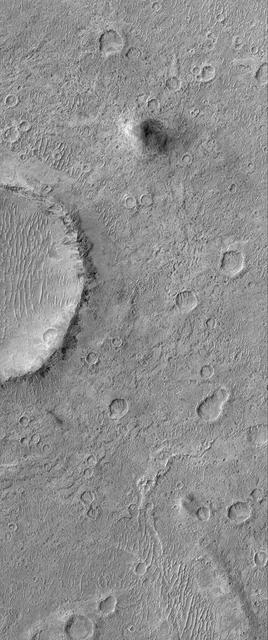
This MOC image shows a cratered plain west of Schiaparelli Crater, Mars. The area captured in this image, and areas adjacent to it, are known for high dust devil traffic
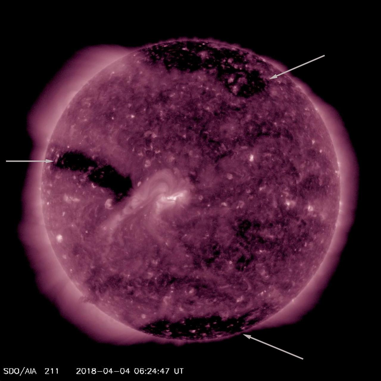
For much of this week the sun featured three substantial coronal holes (Apr. 3-6, 2018). Coronal holes appear as large dark areas which are identified with arrows in the still image. These are areas of open magnetic field from which high speed solar wind rushes out into space. This wind, if it interacts with Earth's magnetosphere, can cause aurora to appear near the poles. They are not at all uncommon. Animations are available at https://photojournal.jpl.nasa.gov/catalog/PIA22414
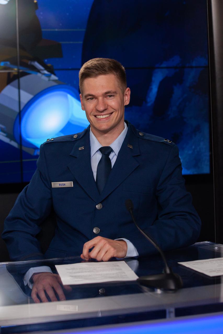
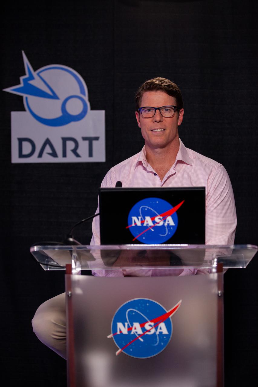
Capt. Maximillian Rush, weather officer for Space Launch Delta 30, participates in a prelaunch news conference for NASA’s Double Asteroid Redirection Test (DART) mission at Vandenberg Space Force Base in California on Nov. 22, 2021. DART is the first mission to test technologies for preventing an impact of Earth by a hazardous asteroid. The mission is scheduled to launch no earlier than 1:21 a.m. EST Wednesday, Nov. 24 (10:21 p.m. PST Tuesday, Nov. 23), aboard a SpaceX Falcon 9 rocket from Vandenberg. NASA's Launch Services Program based at Kennedy Space Center in Florida, America's multi-user spaceport, is managing the launch.
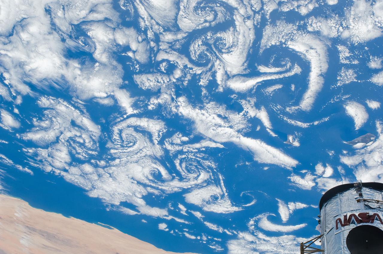
S125-E-007547 (15 May 2009) --- Low-level winds rushing over the Cape Verde Islands off the coast of northwestern Africa created cloud vortex streets which share this scene with the top of the Hubble Space Telescope locked down in the cargo bay of the Earth-orbiting Space Shuttle Atlantis.

Over the past week, the single, largest feature on the sun was a long coronal hole that stretched out across more than half the diameter of the sun (Mar. 13-15, 2018). Coronal holes appear dark in certain wavelengths of extreme ultraviolet light like the one you see here. They are areas of open magnetic fields from which solar wind rushes out into space. This area likely generated the beautiful aurora that were reportedly observed on March 14th in regions near Earth's poles. With the Earth set in the image to show scale, you get a good sense of just how extensive this hole is. Movies are available at https://photojournal.jpl.nasa.gov/catalog/PIA22345
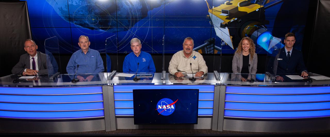
From left, Dr Thomas Zurbuchen, Lindley Johnson, Ed Reynolds, Omar Baez, Julianna Scheiman, and Capt. Maximillian Rush participate in a prelaunch news conference on Nov. 22, 2021, at Vandenberg Space Force Base in California in preparation for the agency’s Double Asteroid Redirection Test (DART) launch. DART is the first mission to test technologies for preventing an impact of Earth by a hazardous asteroid. The mission is scheduled to launch no earlier than 1:21 a.m. EST Wednesday, Nov. 24 (10:21 p.m. PST Tuesday, Nov. 23), aboard a SpaceX Falcon 9 rocket from Vandenberg. NASA's Launch Services Program based at Kennedy Space Center in Florida, America's multi-user spaceport, is managing the launch.
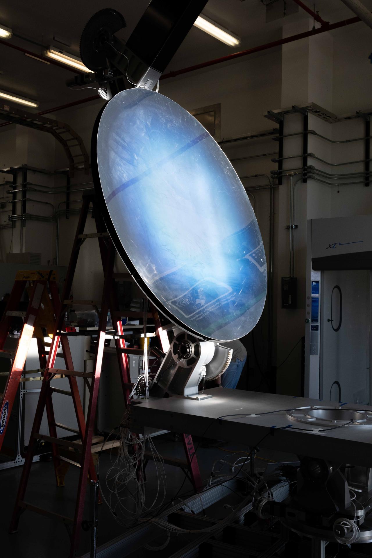
The Carbothermal Reduction Demonstration (CaRD) project aims to demonstrate the carbothermal reduction of lunar regolith to produce oxygen on the Lunar South Pole. For this test, the team integrated the solar concentrator, mirrors, and software and confirmed the production of carbon monoxide.
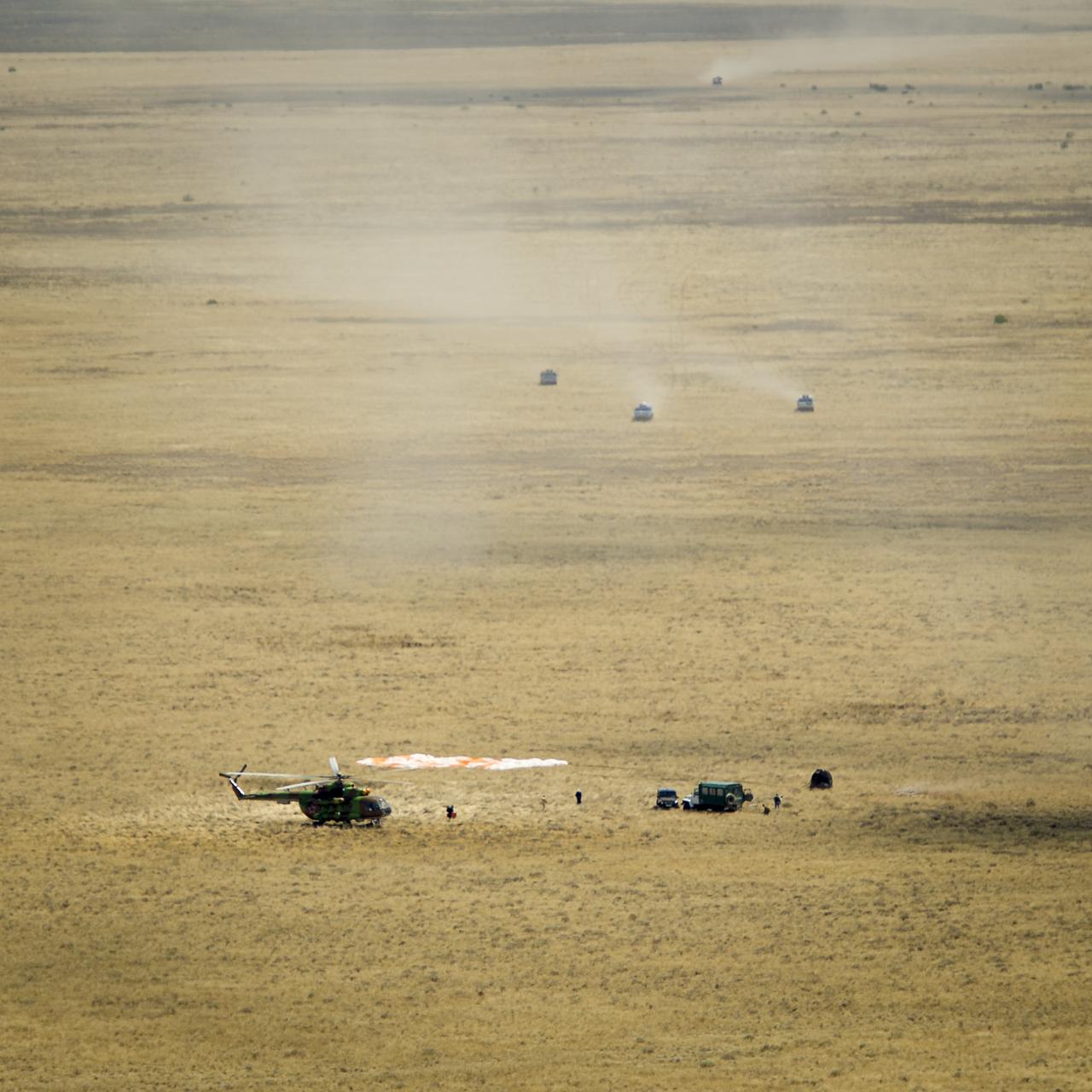
Support personnel rush to the the Soyuz TMA-03M capsule shortly after it landed with Expedition 31 Commander Oleg Kononenko of Russia and Flight Engineers Don Pettit of NASA and Andre Kuipers of the European Space Agency in a remote area near the town of Zhezkazgan, Kazakhstan, on Sunday, July 1, 2012. Pettit, Kononenko and Kuipers returned from more than six months onboard the International Space Station where they served as members of the Expedition 30 and 31 crews. Photo Credit: (NASA/Bill Ingalls)
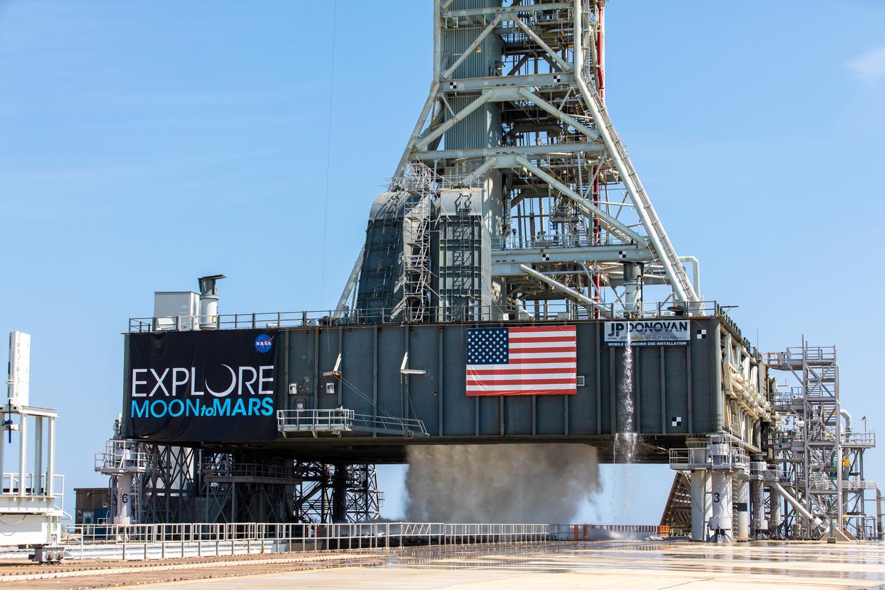
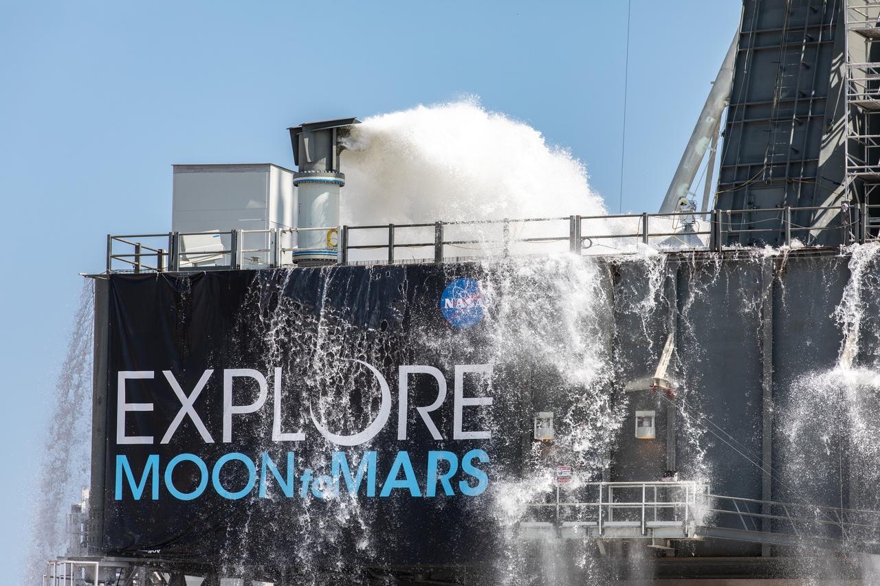
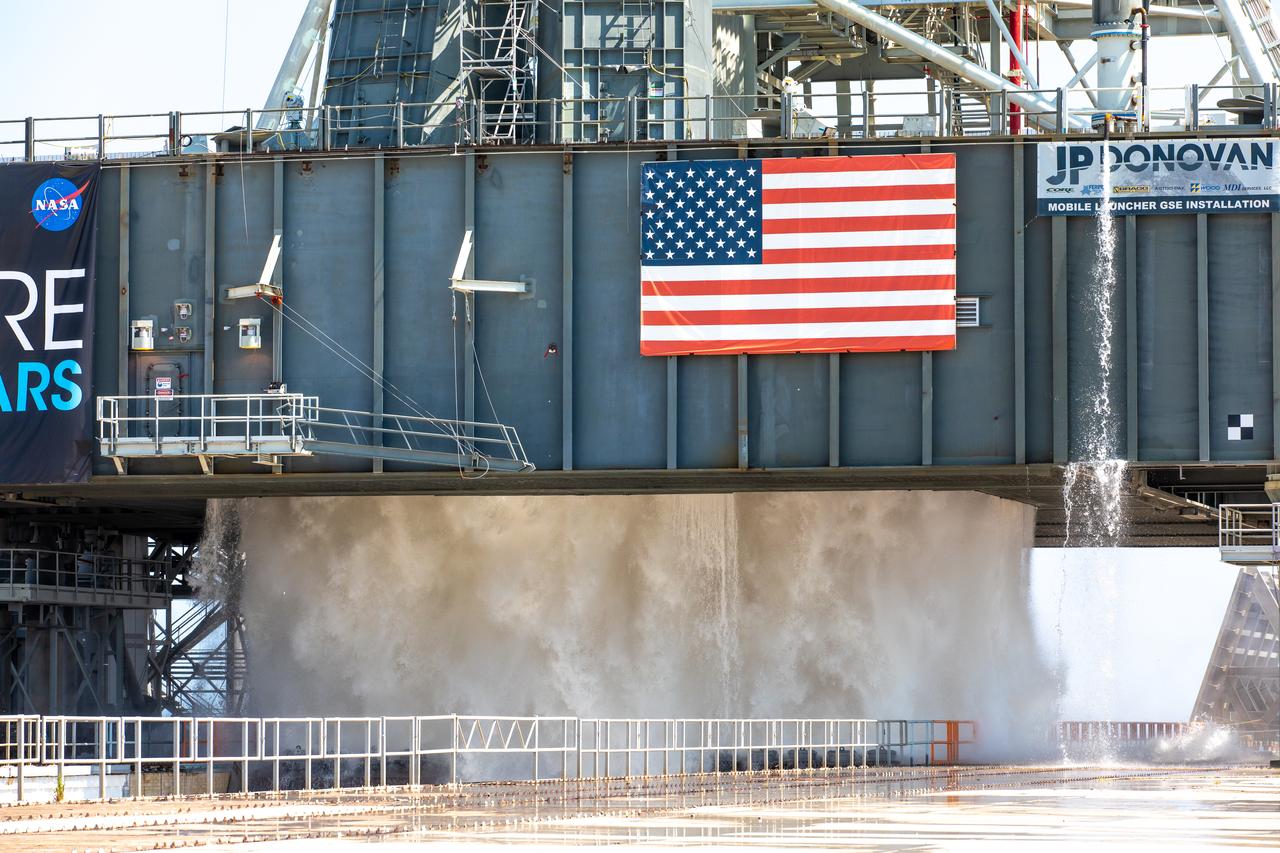
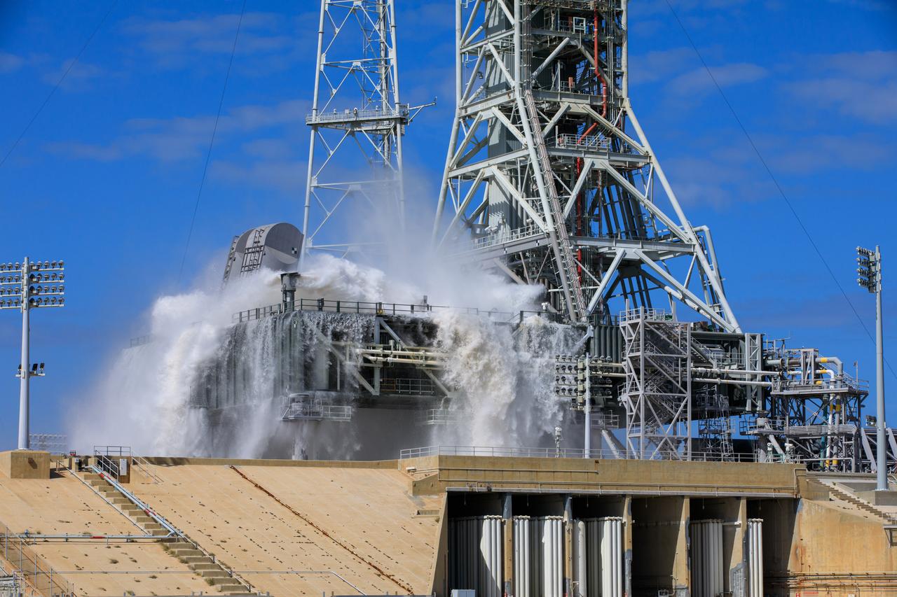
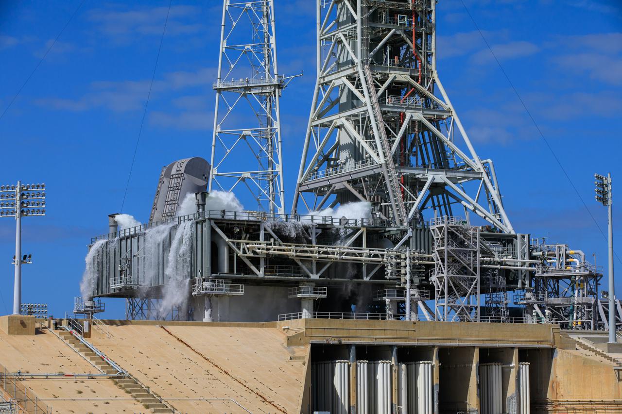
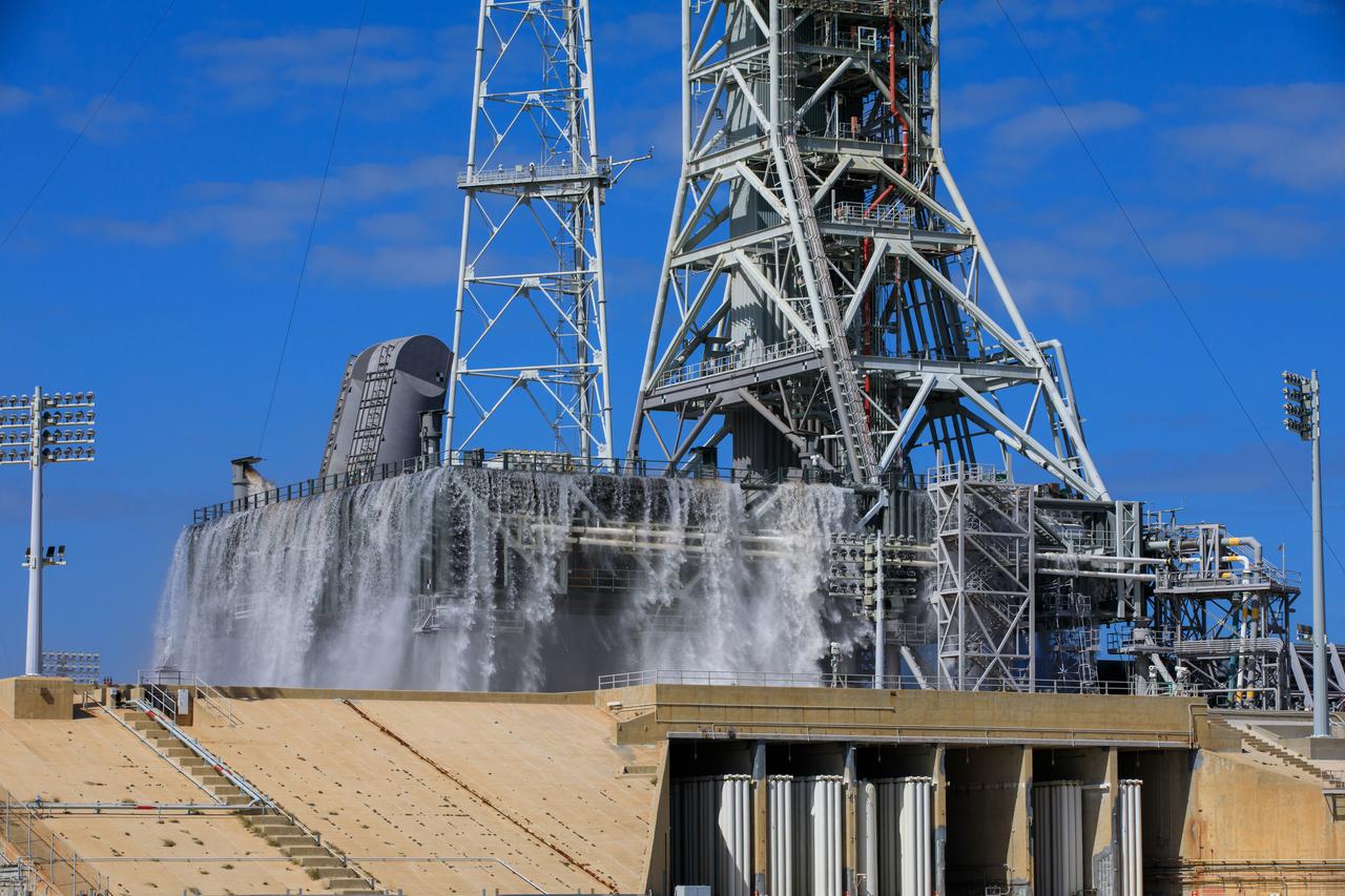
NASA’s Exploration Ground Systems conducts a water flow test with the mobile launcher at Kennedy Space Center’s Pad 39B in Florida on July 2, 2019. It is the first of nine tests to verify the sound suppression system is ready for launch of NASA’s Space Launch System for the first Artemis mission. During launch, 400,000 gallons of water will rush onto the pad to help protect the rocket, NASA’s Orion Spacecraft, mobile launcher, and launch pad from the extreme acoustic and temperature environment.
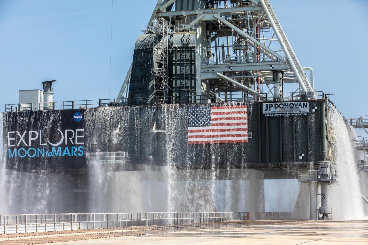
NASA’s Exploration Ground Systems conducts a water flow test with the mobile launcher at Kennedy Space Center’s Pad 39B in Florida on July 2, 2019. It is the first of nine tests to verify the sound suppression system is ready for launch of NASA’s Space Launch System for the first Artemis mission. During launch, 400,000 gallons of water will rush onto the pad to help protect the rocket, NASA’s Orion Spacecraft, mobile launcher, and launch pad from the extreme acoustic and temperature environment.
NASA’s Exploration Ground Systems conducts a water flow test with the mobile launcher at Kennedy Space Center’s Pad 39B in Florida on July 2, 2019. It is the first of nine tests to verify the sound suppression system is ready for launch of NASA’s Space Launch System for the first Artemis mission. During launch, 400,000 gallons of water will rush onto the pad to help protect the rocket, NASA’s Orion Spacecraft, mobile launcher, and launch pad from the extreme acoustic and temperature environment.
NASA’s Exploration Ground Systems conducts a water flow test with the mobile launcher at Kennedy Space Center’s Pad 39B in Florida on July 2, 2019. It is the first of nine tests to verify the sound suppression system is ready for launch of NASA’s Space Launch System for the first Artemis mission. During launch, 400,000 gallons of water will rush onto the pad to help protect the rocket, NASA’s Orion Spacecraft, mobile launcher, and launch pad from the extreme acoustic and temperature environment.
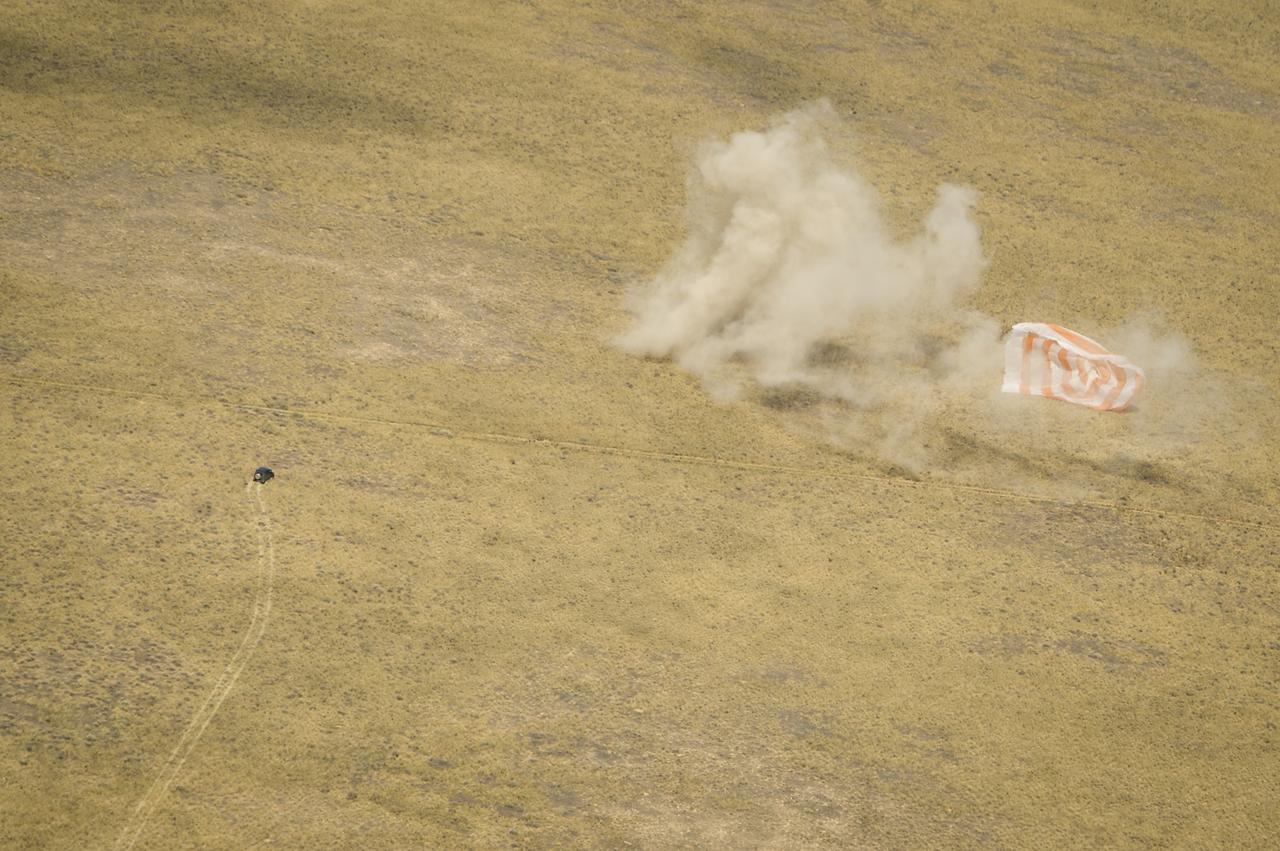
Support personnel rush to the the Soyuz TMA-03M capsule shortly after it landed with Expedition 31 Commander Oleg Kononenko of Russia and Flight Engineers Don Pettit of NASA and Andre Kuipers of the European Space Agency in a remote area near the town of Zhezkazgan, Kazakhstan, on Sunday, July 1, 2012. Pettit, Kononenko and Kuipers returned from more than six months onboard the International Space Station where they served as members of the Expedition 30 and 31 crews. Photo Credit: (NASA/Bill Ingalls)
NASA’s Exploration Ground Systems conducts a water flow test with the mobile launcher at Kennedy Space Center’s Pad 39B in Florida on July 2, 2019. It is the first of nine tests to verify the sound suppression system is ready for launch of NASA’s Space Launch System for the first Artemis mission. During launch, 400,000 gallons of water will rush onto the pad to help protect the rocket, NASA’s Orion Spacecraft, mobile launcher, and launch pad from the extreme acoustic and temperature environment.
NASA’s Exploration Ground Systems conducts a water flow test with the mobile launcher at Kennedy Space Center’s Pad 39B in Florida on July 2, 2019. It is the first of nine tests to verify the sound suppression system is ready for launch of NASA’s Space Launch System for the first Artemis mission. During launch, 400,000 gallons of water will rush onto the pad to help protect the rocket, NASA’s Orion Spacecraft, mobile launcher, and launch pad from the extreme acoustic and temperature environment.
NASA’s Exploration Ground Systems conducts a water flow test with the mobile launcher at Kennedy Space Center’s Pad 39B in Florida on July 2, 2019. It is the first of nine tests to verify the sound suppression system is ready for launch of NASA’s Space Launch System for the first Artemis mission. During launch, 400,000 gallons of water will rush onto the pad to help protect the rocket, NASA’s Orion Spacecraft, mobile launcher, and launch pad from the extreme acoustic and temperature environment.
NASA’s Exploration Ground Systems conducts a water flow test with the mobile launcher at Kennedy Space Center’s Pad 39B in Florida on July 2, 2019. It is the first of nine tests to verify the sound suppression system is ready for launch of NASA’s Space Launch System for the first Artemis mission. During launch, 400,000 gallons of water will rush onto the pad to help protect the rocket, NASA’s Orion Spacecraft, mobile launcher, and launch pad from the extreme acoustic and temperature environment.
Support personnel rush to the the Soyuz TMA-03M capsule shortly after it landed with Expedition 31 Commander Oleg Kononenko of Russia and Flight Engineers Don Pettit of NASA and Andre Kuipers of the European Space Agency in a remote area near the town of Zhezkazgan, Kazakhstan, on Sunday, July 1, 2012. Pettit, Kononenko and Kuipers returned from more than six months onboard the International Space Station where they served as members of the Expedition 30 and 31 crews. Photo Credit: (NASA/Bill Ingalls)
NASA’s Exploration Ground Systems conducts a water flow test with the mobile launcher at Kennedy Space Center’s Pad 39B in Florida on July 2, 2019. It is the first of nine tests to verify the sound suppression system is ready for launch of NASA’s Space Launch System for the first Artemis mission. During launch, 400,000 gallons of water will rush onto the pad to help protect the rocket, NASA’s Orion Spacecraft, mobile launcher, and launch pad from the extreme acoustic and temperature environment.

According to one ancient legend, a Chinese official named Wan Hoo attempted a flight to the moon using a large wicker chair to which were fastened 47 large rockets. Forty seven assistants, each armed with a torch, rushed forward to light the fuses. In a moment, there was a tremendous roar accompanied by billowing clouds of smoke. When the smoke cleared, the flying chair and Wan Hoo were gone.
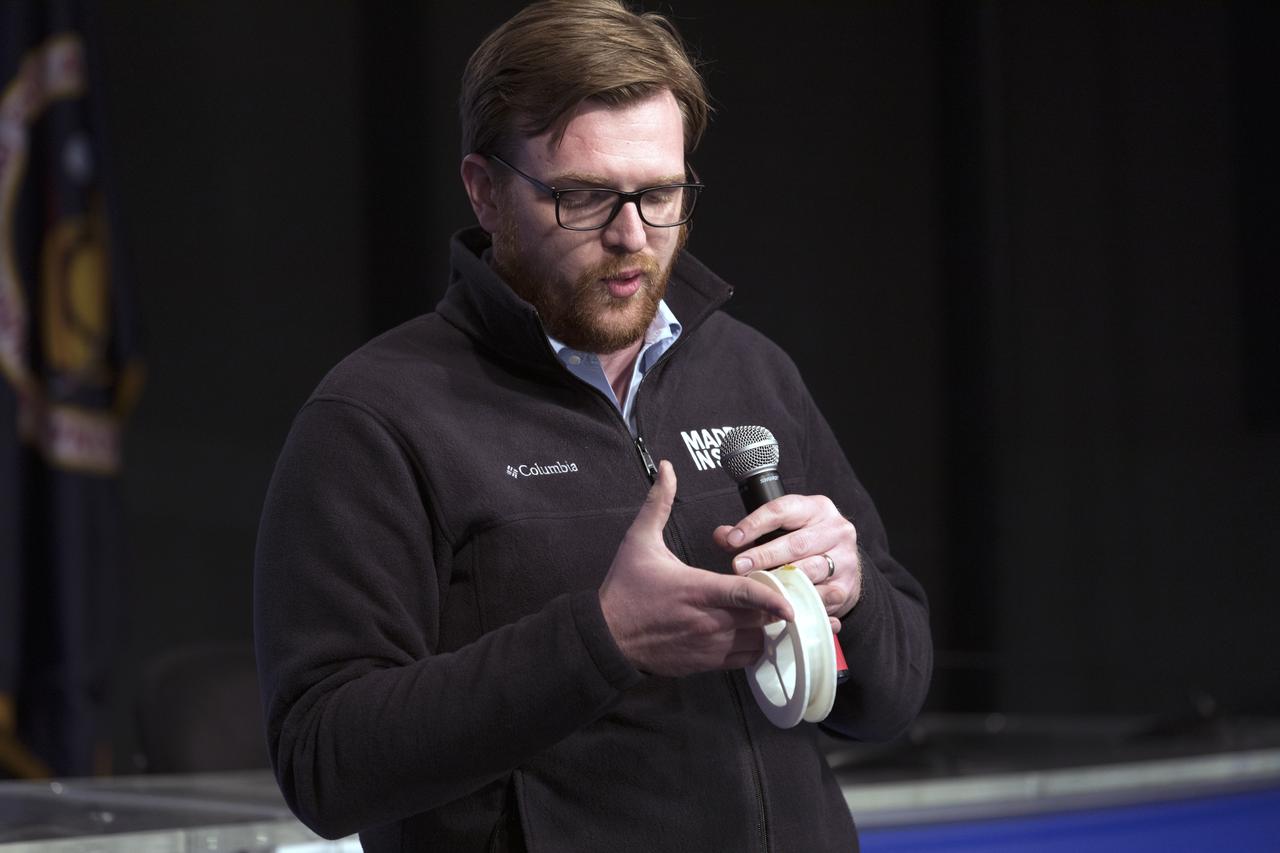
Andrew Rush, president and chief executive officer of Made in Space, discusses his company's Fiber Optics payload, with members of social media in the Kennedy Space Center’s Press Site auditorium. The briefing focused on research planned for launch to the International Space Station. The scientific materials and supplies will be aboard a Dragon spacecraft scheduled for liftoff from Cape Canaveral Air Force Station's Space Launch Complex 40 at 11:46 a.m. EST, on Dec. 12, 2017. The SpaceX Falcon 9 rocket will launch the company's 13th Commercial Resupply Services mission to the space station.

Andrew Rush, president and chief executive officer of Made in Space, discusses his company's Fiber Optics payload, with members of social media in the Kennedy Space Center’s Press Site auditorium. The briefing focused on research planned for launch to the International Space Station. The scientific materials and supplies will be aboard a Dragon spacecraft scheduled for liftoff from Cape Canaveral Air Force Station's Space Launch Complex 40 at 11:46 a.m. EST, on Dec. 12, 2017. The SpaceX Falcon 9 rocket will launch the company's 13th Commercial Resupply Services mission to the space station.
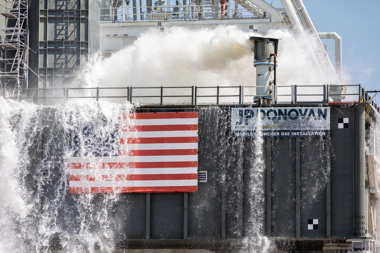
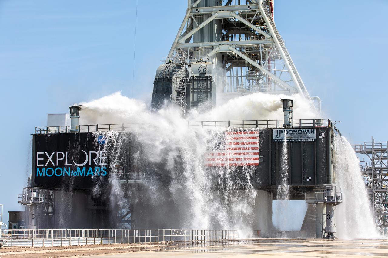
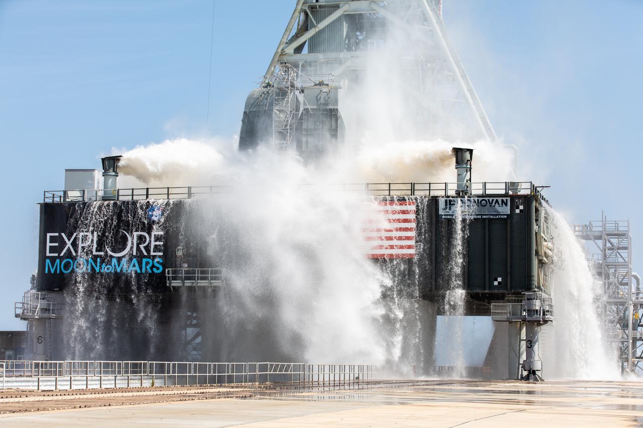
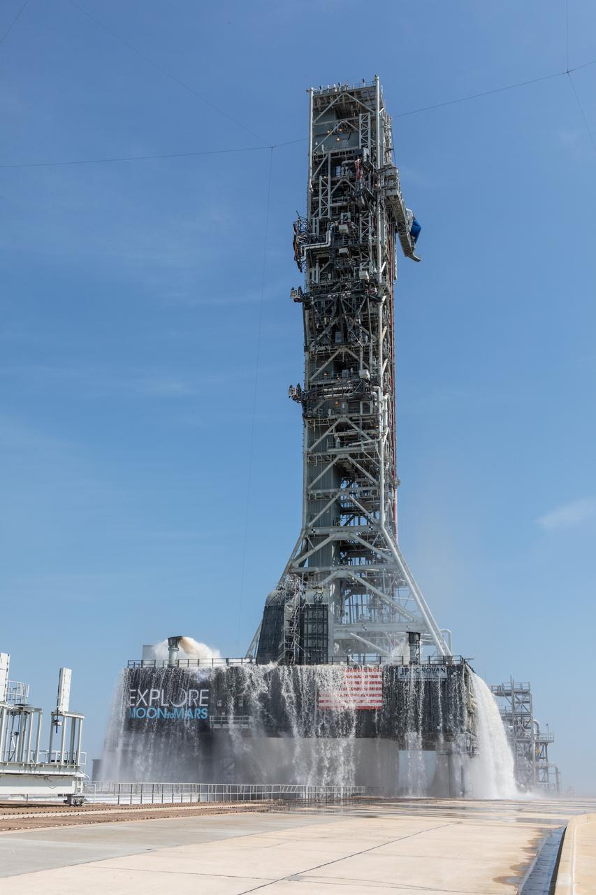
NASA’s Exploration Ground Systems conducts a water flow test with the mobile launcher at Kennedy Space Center’s Launch Complex 39B in Florida on Oct. 24, 2023. It is the third in a series of tests to verify the overpressure protection and sound suppression system is ready for launch of the Artemis II mission. During liftoff, 400,000 gallons of water will rush onto the pad to help protect NASA’s SLS (Space Launch System) rocket, Orion spacecraft, mobile launcher, and launch pad from any over pressurization and extreme sound produced during ignition and liftoff.
NASA’s Exploration Ground Systems conducts a water flow test with the mobile launcher at Kennedy Space Center’s Launch Complex 39B in Florida on Oct. 24, 2023. It is the third in a series of tests to verify the overpressure protection and sound suppression system is ready for launch of the Artemis II mission. During liftoff, 400,000 gallons of water will rush onto the pad to help protect NASA’s SLS (Space Launch System) rocket, Orion spacecraft, mobile launcher, and launch pad from any over pressurization and extreme sound produced during ignition and liftoff.
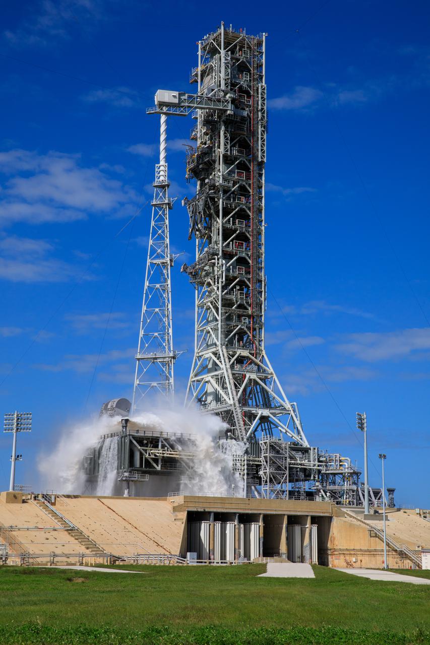
NASA’s Exploration Ground Systems conducts a water flow test with the mobile launcher at Kennedy Space Center’s Launch Complex 39B in Florida on Oct. 24, 2023. It is the third in a series of tests to verify the overpressure protection and sound suppression system is ready for launch of the Artemis II mission. During liftoff, 400,000 gallons of water will rush onto the pad to help protect NASA’s SLS (Space Launch System) rocket, Orion spacecraft, mobile launcher, and launch pad from any over pressurization and extreme sound produced during ignition and liftoff.
NASA’s Exploration Ground Systems conducts a water flow test with the mobile launcher at Kennedy Space Center’s Launch Complex 39B in Florida on Oct. 24, 2023. It is the third in a series of tests to verify the overpressure protection and sound suppression system is ready for launch of the Artemis II mission. During liftoff, 400,000 gallons of water will rush onto the pad to help protect NASA’s SLS (Space Launch System) rocket, Orion spacecraft, mobile launcher, and launch pad from any over pressurization and extreme sound produced during ignition and liftoff.
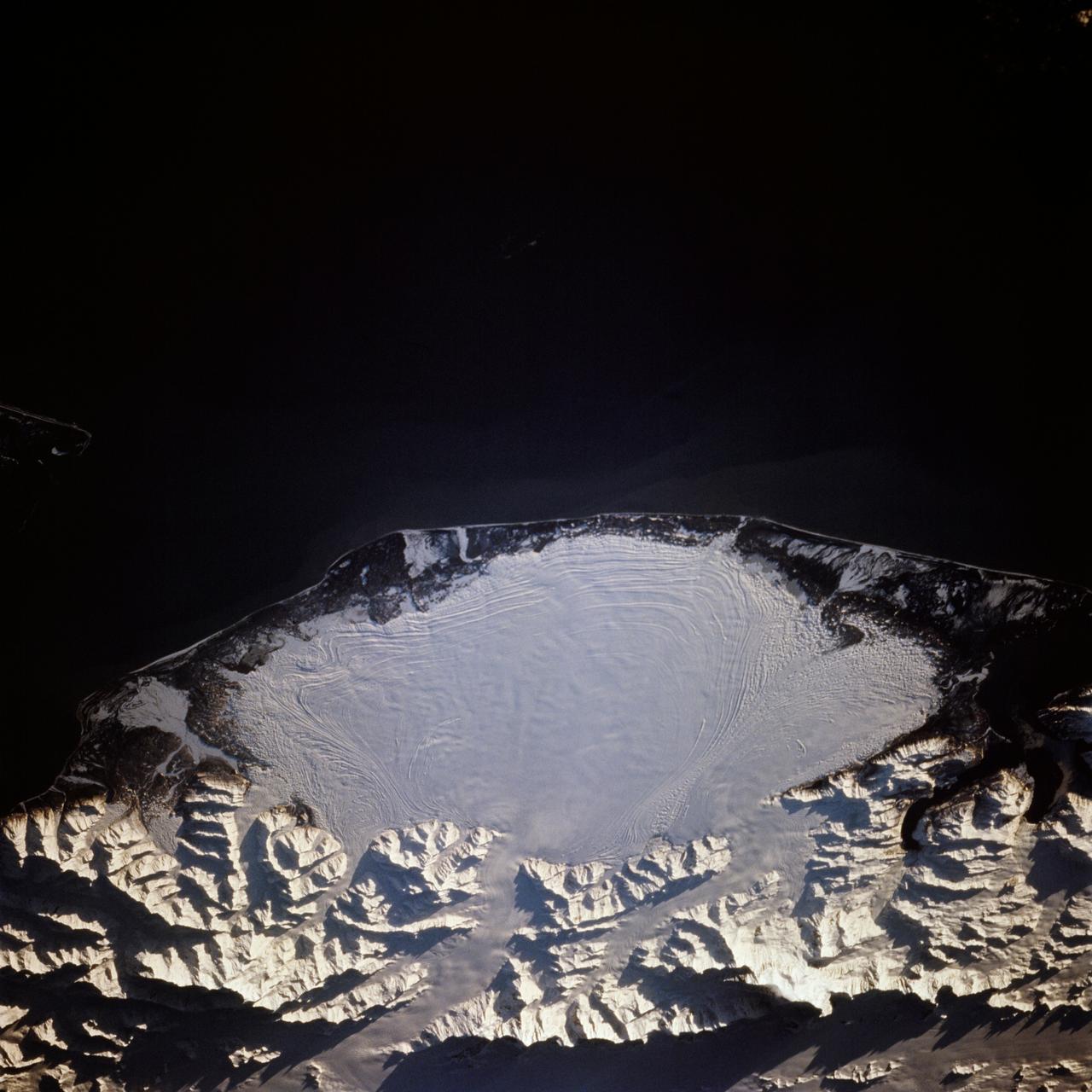
STS066-117-014 (3-14 Nov. 1994) --- Malaspina Glacier can be seen in this north-northeastern photograph taken in November, 1994. The glacier, located in the south shore of Alaska is a classic example of a piedmont glacier lying along the foot of a mountain range. The principal source of ice for the glacier is provided by the Seward Ice Field to the north (top portion of the view) which flows through three narrow outlets onto the coastal plain. The glacier moves in surges that rush earlier-formed moraines outward into the expanding concentric patterns along the flanks of the ice mass.
NASA’s Exploration Ground Systems conducts a water flow test with the mobile launcher at Kennedy Space Center’s Launch Complex 39B in Florida on Oct. 24, 2023. It is the third in a series of tests to verify the overpressure protection and sound suppression system is ready for launch of the Artemis II mission. During liftoff, 400,000 gallons of water will rush onto the pad to help protect NASA’s SLS (Space Launch System) rocket, Orion spacecraft, mobile launcher, and launch pad from any over pressurization and extreme sound produced during ignition and liftoff.
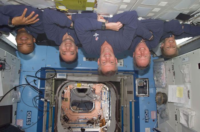
STS98-E-5284 (15 February 2001) --- These five astronauts take a break from Destiny laboratory installation work as they near an end to their several days' visit aboard the International Space Station (ISS). From the left are astronauts Robert L. Curbeam, Mark L. Polansky, Kenneth D. Cockrell, Thomas D. Jones and Marsha S. Ivins. Their posed position might be termed "upside down" on Earth, but in their weightless environment the arrangement makes for no one-gravity complications like blood rushing to the head, etc. The scene was recorded with a digital still camera.

NASA’s Exploration Ground Systems conducts a water flow test with the mobile launcher at Kennedy Space Center’s Launch Complex 39B in Florida on Oct. 24, 2023. It is the third in a series of tests to verify the overpressure protection and sound suppression system is ready for launch of the Artemis II mission. During liftoff, 400,000 gallons of water will rush onto the pad to help protect NASA’s SLS (Space Launch System) rocket, Orion spacecraft, mobile launcher, and launch pad from any over pressurization and extreme sound produced during ignition and liftoff.
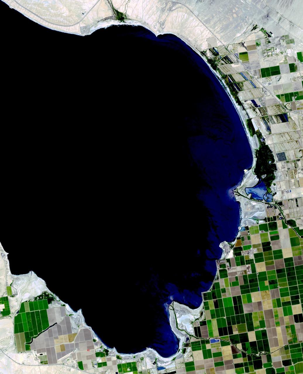
The Salton Sea in south California was created in 1905 when spring flooding on the Colorado River breached a canal. For 18 months the entire volume of the river rushed into the Salton Trough, creating a lake 32 km wide and 72 km long. In the 1950s, resorts sprang up along the shores. However, shrinking of the lake and increased salinity led to the abandonment of the resorts. The two images show the shrinking lake on May 31, 1984 (Landsat) and June 14, 2015 (ASTER). The images cover an area of 37.5 x 27 km, and are located at 33.2 degrees north, 115.7 degrees west. http://photojournal.jpl.nasa.gov/catalog/PIA19786
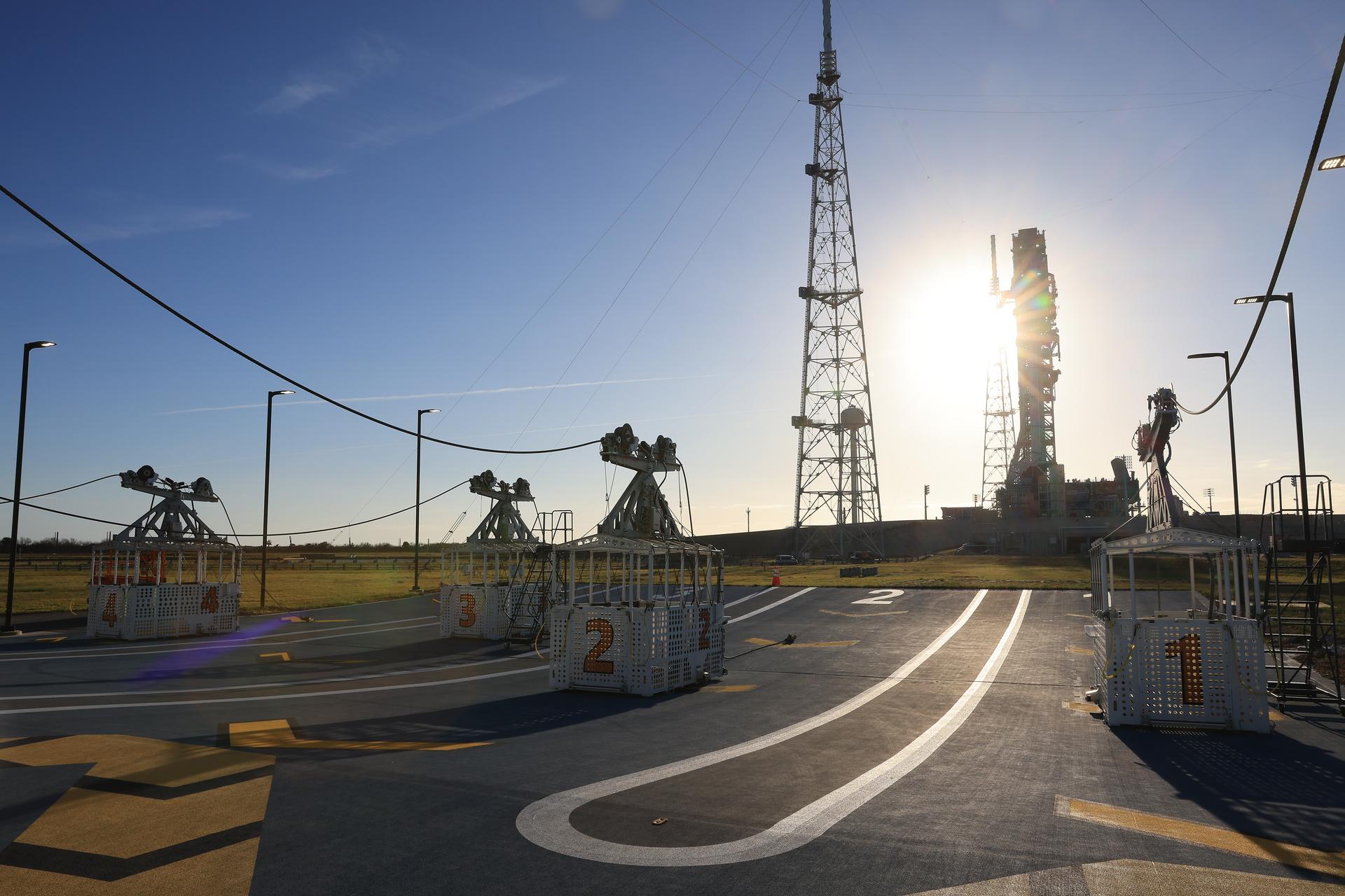
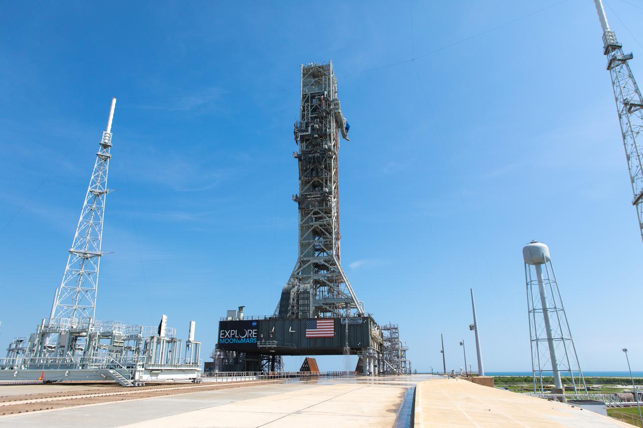
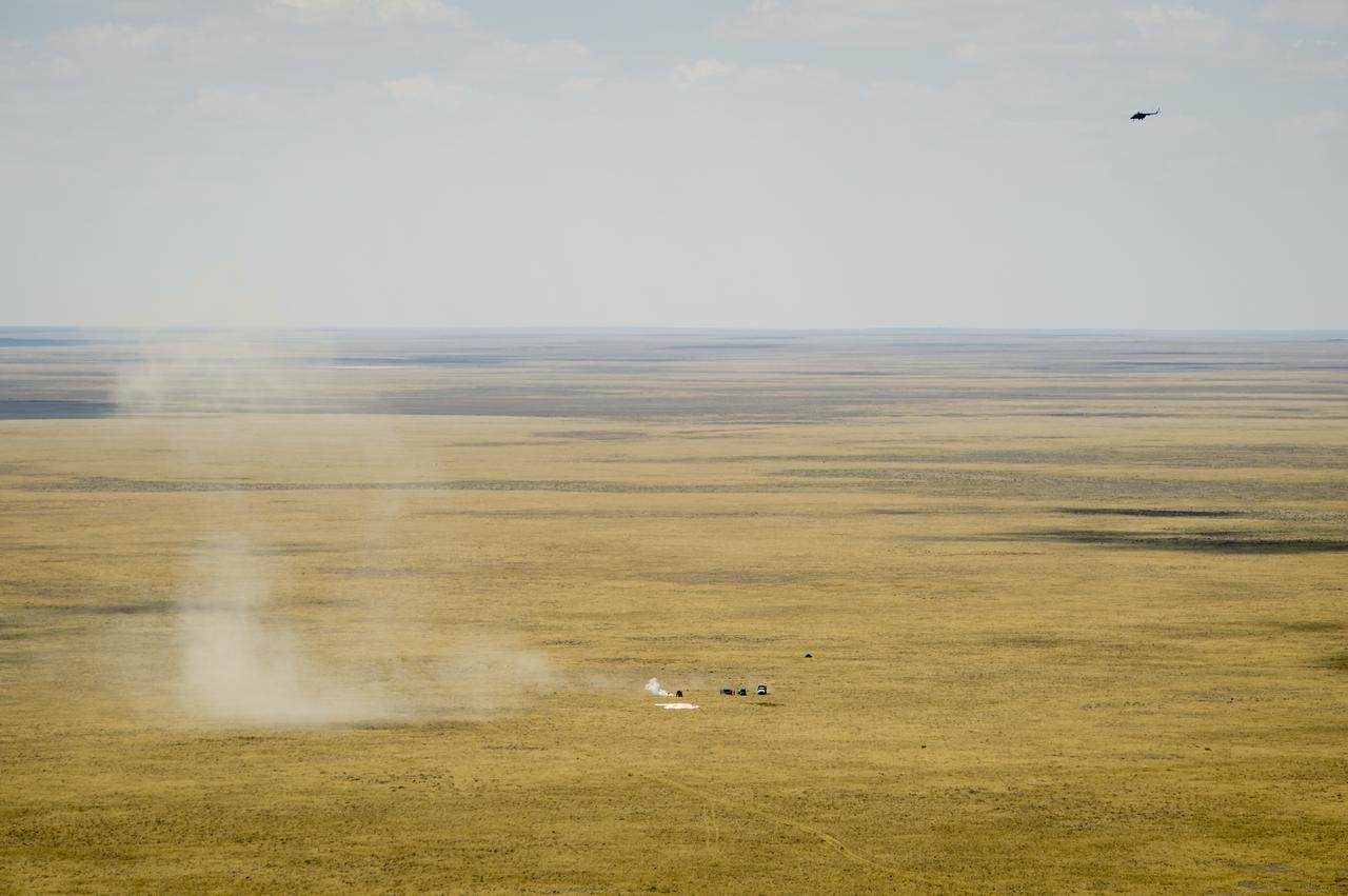
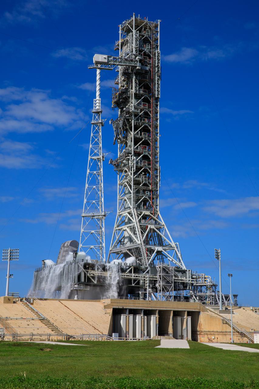
NASA’s mobile launcher 1 begins its approximately 4-mile trek from Launch Complex 39B to the Vehicle Assembly Building (VAB) at the agency’s Kennedy Space Center in Florida on Thursday, April 16, 2026, in preparation for Artemis III stacking operations. Nearby is the emergency egress system, an abort system for personnel to climb into four baskets at the top of the mobile launcher and rush to the base of the pad in the unlikely event of an emergency during launch. Once at the VAB, teams will perform checkouts, inspections, and data analysis, and make repairs to the tower that saw damage during liftoff of the Artemis II test flight.
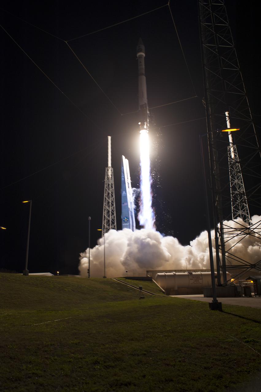
CAPE CANAVERAL, Fla. – The United Launch Alliance Delta IV rocket carrying NASA's GOES-P meteorological satellite rushes to orbit from Launch Complex 37 on Cape Canaveral Air Force Station in Florida. Liftoff was at 6:57 p.m. EST. GOES-P, the latest Geostationary Operational Environmental Satellite, was developed by NASA for the National Oceanic and Atmospheric Administration, or NOAA. The GOES-P spacecraft will be placed in a 22,300-mile-high geosynchronous orbit where it will appear to hover over a single point on Earth. The spacecraft is outfitted with a complex suite of observation instruments and cameras so it can accurately report on weather and climate conditions on Earth. For information on GOES-P, visit http:__www.nasa.gov_mission_pages_GOES-P_main_index.html. Photo credit: NASA_Sandra Joseph and Tony Gray
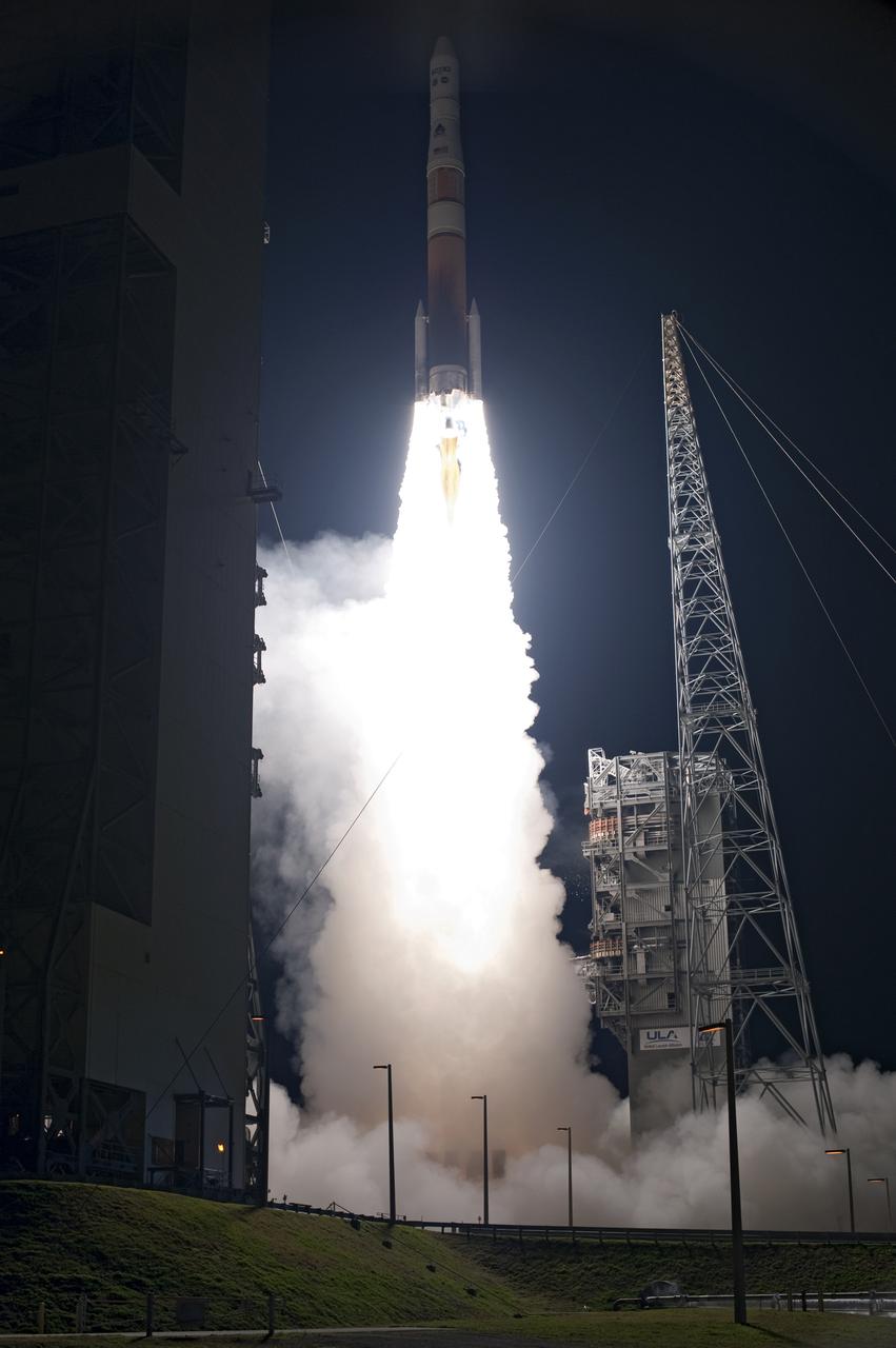
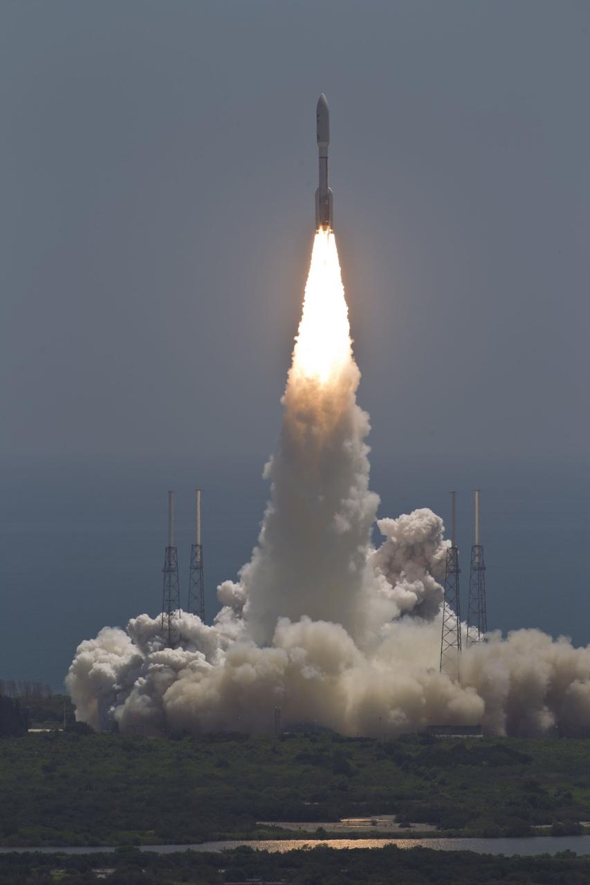
CAPE CANAVERAL, Fla. -- A United Launch Alliance Atlas V 401 rocket rushes past the lightning masts on Space Launch Complex 41 on Cape Canaveral Air Force Station in Florida, leaving plumes of exhaust and smoke in its wake. Its payload, NASA's Tracking and Data Relay Satellite-K or TDRS-K, began its climb to orbit at 8:48 p.m. EST. The TDRS-K spacecraft is part of the next-generation series in the Tracking and Data Relay Satellite System, a constellation of space-based communication satellites providing tracking, telemetry, command and high-bandwidth data return services. For more information, visit http:__www.nasa.gov_mission_pages_tdrs_index.html. Photo credit: NASA_Tony Gray and Rick Wetherington
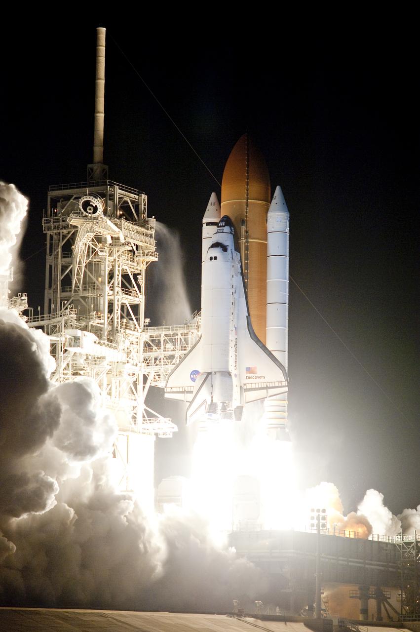
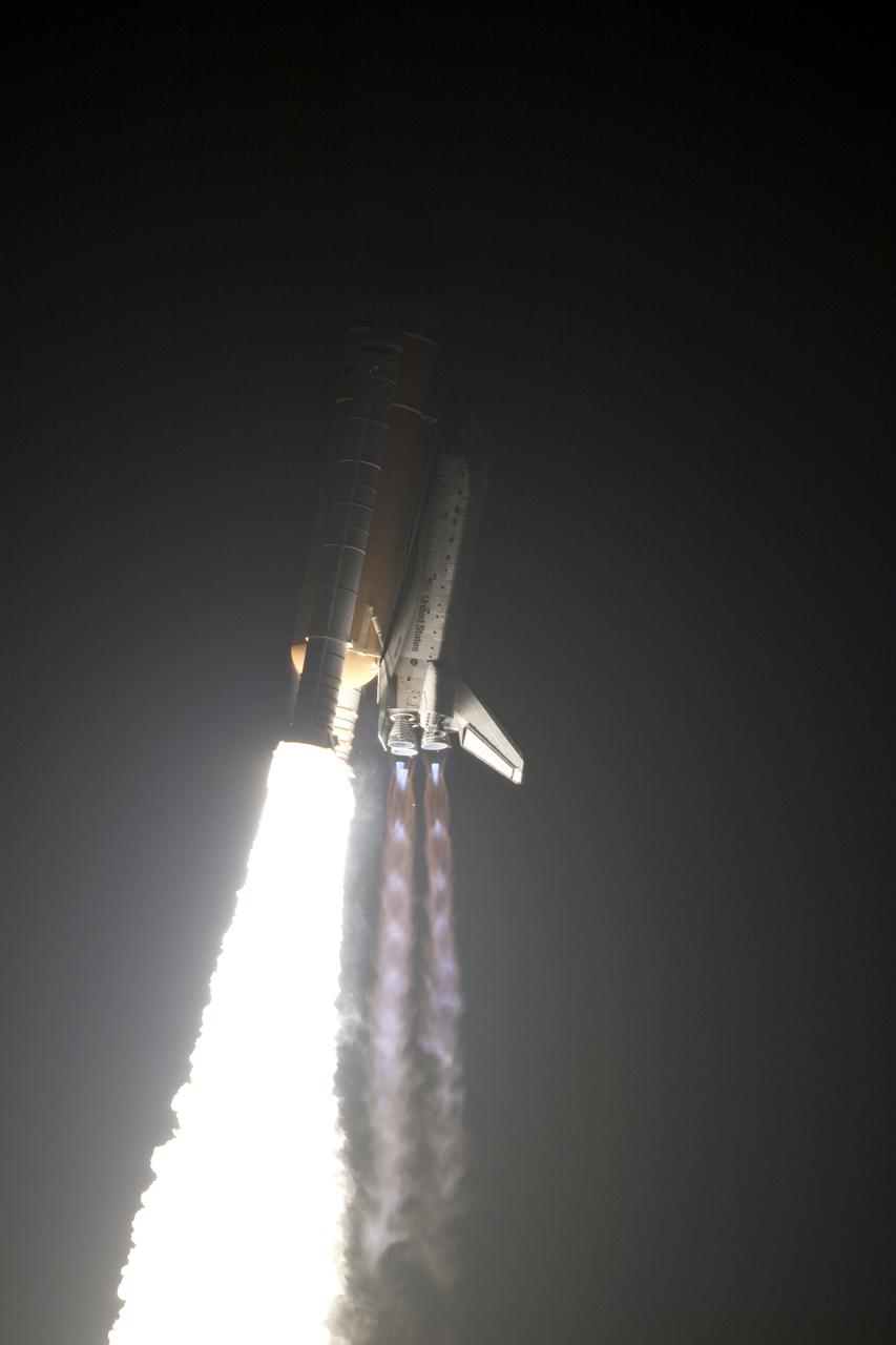
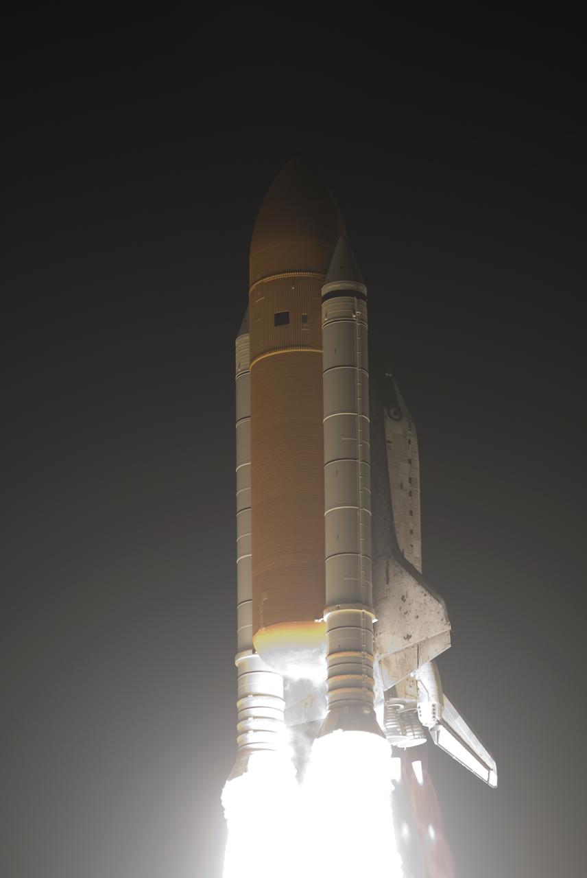
CAPE CANAVERAL, Fla. - The light produced by ignition of the solid rocket boosters and main engines of space shuttle Discovery is dazzling as the shuttle rushes to orbit from Launch Pad 39A at NASA's Kennedy Space Center in Florida. Liftoff on the STS-131 mission was on time at 6:21 a.m. EDT. The seven-member crew will deliver the multi-purpose logistics module Leonardo, filled with supplies, a new crew sleeping quarters and science racks that will be transferred to the International Space Station's laboratories. The crew also will switch out a gyroscope on the station’s truss, install a spare ammonia storage tank and retrieve a Japanese experiment from the station’s exterior. STS-131 is the 33rd shuttle mission to the station and the 131st shuttle mission overall. For information on the STS-131 mission and crew, visit http:__www.nasa.gov_mission_pages_shuttle_shuttlemissions_sts131_index.html. Photo credit: NASA_Sandra Joseph and Kevin O'Connell

It is known today that merging galaxies play a large role in the evolution of galaxies and the formation of elliptical galaxies in particular. However there are only a few merging systems close enough to be observed in depth. The pair of interacting galaxies picture seen here — known as NGC 3921 — is one of these systems. NGC 3921 — found in the constellation of Ursa Major (The Great Bear) — is an interacting pair of disc galaxies in the late stages of its merger. Observations show that both of the galaxies involved were about the same mass and collided about 700 million years ago. You can see clearly in this image the disturbed morphology, tails and loops characteristic of a post-merger. The clash of galaxies caused a rush of star formation and previous Hubble observations showed over 1000 bright, young star clusters bursting to life at the heart of the galaxy pair.

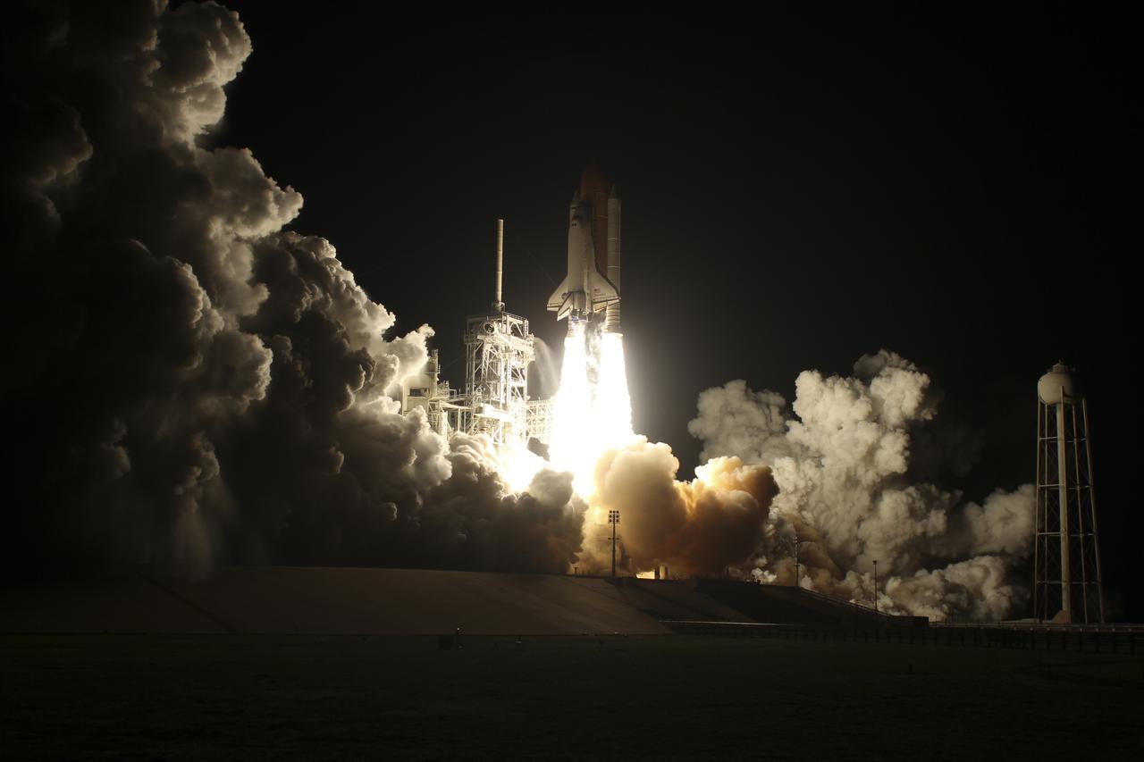
KENNEDY SPACE CENTER, FLA. -- Rising from clouds of smoke and steam, Space Shuttle Atlantis rushes into the night sky as it lifts off from Launch Pad 39A. The glare of the flames and clouds is captured in the water near the pad. Liftoff occurred at 6:13:02 p.m. EST. Along with a crew of five, Atlantis is carrying the U.S. Laboratory Destiny, a key module in the growth of the Space Station. Destiny will be attached to the Unity node on the Space Station using the Shuttle’s robotic arm. Three spacewalks are required to complete the planned construction work during the 11-day mission. This mission marks the seventh Shuttle flight to the Space Station, the 23rd flight of Atlantis and the 102nd flight overall in NASA’s Space Shuttle program. The planned landing is at KSC Feb. 18 about 1:00 p.m. EST
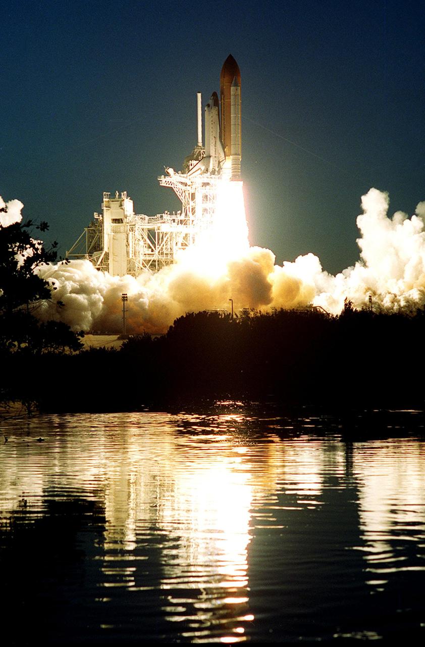
KENNEDY SPACE CENTER, FLA. -- Rising from clouds of smoke and steam, Space Shuttle Atlantis rushes into the night sky as it lifts off from Launch Pad 39A. The glare of the flames and clouds is captured in the water near the pad. Liftoff occurred at 6:13:02 p.m. EST. Along with a crew of five, Atlantis is carrying the U.S. Laboratory Destiny, a key module in the growth of the Space Station. Destiny will be attached to the Unity node on the Space Station using the Shuttle’s robotic arm. Three spacewalks are required to complete the planned construction work during the 11-day mission. This mission marks the seventh Shuttle flight to the Space Station, the 23rd flight of Atlantis and the 102nd flight overall in NASA’s Space Shuttle program. The planned landing is at KSC Feb. 18 about 1:00 p.m. EST
CAPE CANAVERAL, Fla. - The light from the solid rocket boosters and main engines of space shuttle Discovery is blinding as the shuttle rushes to orbit from Launch Pad 39A at NASA's Kennedy Space Center. Liftoff on the STS-131 mission was on time at 6:21 a.m. EDT. The seven-member crew will deliver the multi-purpose logistics module Leonardo, filled with supplies, a new crew sleeping quarters and science racks that will be transferred to the International Space Station's laboratories. The crew also will switch out a gyroscope on the station’s truss, install a spare ammonia storage tank and retrieve a Japanese experiment from the station’s exterior. STS-131 is the 33rd shuttle mission to the station and the 131st shuttle mission overall. For information on the STS-131 mission and crew, visit http:__www.nasa.gov_mission_pages_shuttle_shuttlemissions_sts131_index.html. Photo credit: NASA_Kenny Allen
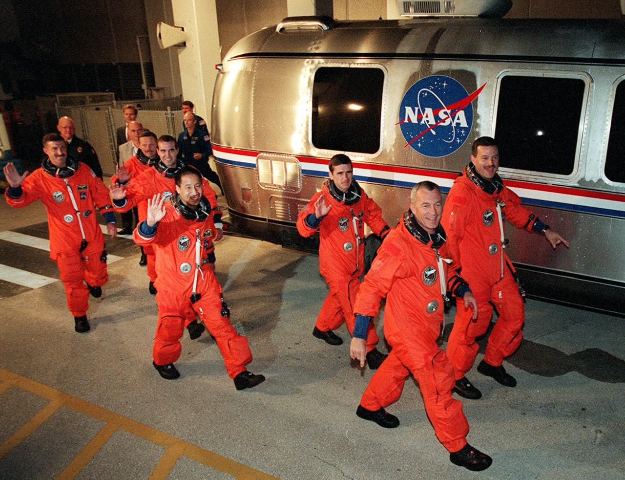
The STS-106 crew wave to onlookers as they rush to the Astrovan that will take them to Launch Pad 39B. From left to right are Mission Specialists Daniel C. Burbank, Boris V. Morukov, Richard A. Mastracchio, Edward T. Lu and Yuri I. Malenchenko; Commander Terrence W. Wilcutt; and Pilot Scott D. Altman. Liftoff of Space Shuttle Atlantis is set for 8:45 a.m. EDT on the fourth flight to the International Space Station. On the 11-day mission, the seven-member crew will perform support tasks on orbit, transfer supplies and prepare the living quarters in the newly arrived Zvezda Service Module. The first long-duration crew, dubbed “Expedition One,” is due to arrive at the Station in late fall
CAPE CANAVERAL, Fla. - The light from the solid rocket boosters and main engines of space shuttle Discovery is dazzling as the shuttle rushes into the predawn sky over Launch Pad 39A at NASA's Kennedy Space Center. Liftoff on the STS-131 mission was on time at 6:21 a.m. EDT April 5. The seven-member crew will deliver the multi-purpose logistics module Leonardo, filled with supplies, a new crew sleeping quarters and science racks that will be transferred to the International Space Station's laboratories. The crew also will switch out a gyroscope on the station’s truss, install a spare ammonia storage tank and retrieve a Japanese experiment from the station’s exterior. STS-131 is the 33rd shuttle mission to the station and the 131st shuttle mission overall. For information on the STS-131 mission and crew, visit http:__www.nasa.gov_mission_pages_shuttle_shuttlemissions_sts131_index.html. Photo credit: NASA_Rusty Backer and Michael Gayle
CAPE CANAVERAL, Fla. - The light produced by ignition of the solid rocket boosters and main engines of space shuttle Discovery is dazzling as the shuttle rushes to orbit from Launch Pad 39A at NASA's Kennedy Space Center in Florida. Liftoff on the STS-131 mission was on time at 6:21 a.m. EDT April 5. The seven-member crew will deliver the multi-purpose logistics module Leonardo, filled with supplies, a new crew sleeping quarters and science racks that will be transferred to the International Space Station's laboratories. The crew also will switch out a gyroscope on the station’s truss, install a spare ammonia storage tank and retrieve a Japanese experiment from the station’s exterior. STS-131 is the 33rd shuttle mission to the station and the 131st shuttle mission overall. For information on the STS-131 mission and crew, visit http:__www.nasa.gov_mission_pages_shuttle_shuttlemissions_sts131_index.html. Photo courtesy of Scott Andrews
CAPE CANAVERAL, Fla. -- NASA's Juno planetary probe, enclosed in its payload fairing atop a United Launch Alliance Atlas V-551 launch vehicle, rushes above the towers of the lightning protection system at Space Launch Complex 41 on Cape Canaveral Air Force Station in Florida. Liftoff was at 12:25 p.m. EDT Aug. 5. The solar-powered spacecraft will orbit Jupiter's poles 33 times to find out more about the gas giant's origins, structure, atmosphere and magnetosphere and investigate the existence of a solid planetary core. NASA's Jet Propulsion Laboratory, Pasadena, Calif., manages the Juno mission for the principal investigator, Scott Bolton, of Southwest Research Institute in San Antonio. The Juno mission is part of the New Frontiers Program managed at NASA's Marshall Space Flight Center in Huntsville, Ala. Lockheed Martin Space Systems, Denver, built the spacecraft. Launch management for the mission is the responsibility of NASA's Launch Services Program at the Kennedy Space Center in Florida. For more information, visit www.nasa.gov/juno. Photo credit: Courtesy of Scott Andrews
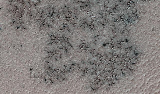
This image shows spidery channels eroded into Martian ground. It is an example from high-resolution observation of more than 20 places that were chosen in 2016 on the basis of about 10,000 volunteers' examination of lower-resolution images of larger areas near Mars' south pole. These sharper looks use the High Resolution Imaging Science Experiment (HiRISE) camera on NASA's Mars Reconnaissance Orbiter. The volunteers, through the Planet Four: Terrains website, categorize surface features in images from the same orbiter's Context Camera (CTX). This image is a portion of HiRISE observation ESP_047487_1005, taken on Sept. 12, 2016, of a site at 79.4 degrees south latitude, 18.8 degrees east longitude. The ground area shown is about half a mile (0.8 kilometer) wide. This terrain type, called spiders or "araneiform" (from the Latin word for spiders), appears in some areas of far-southern Mars that are covered by sheets of frozen carbon dioxide ("dry ice") during the winter. When the slab ice thaws from the underneath side in the spring, carbon dioxide gas trapped beneath the ice builds pressure until it rushes toward a fissure or vent where it bursts out. The venting gas carries dust and sand that it picks up as it carves these channels. At this location, the spiders are surrounded by ground called "basketball terrain" because of its texture. http://photojournal.jpl.nasa.gov/catalog/PIA21126
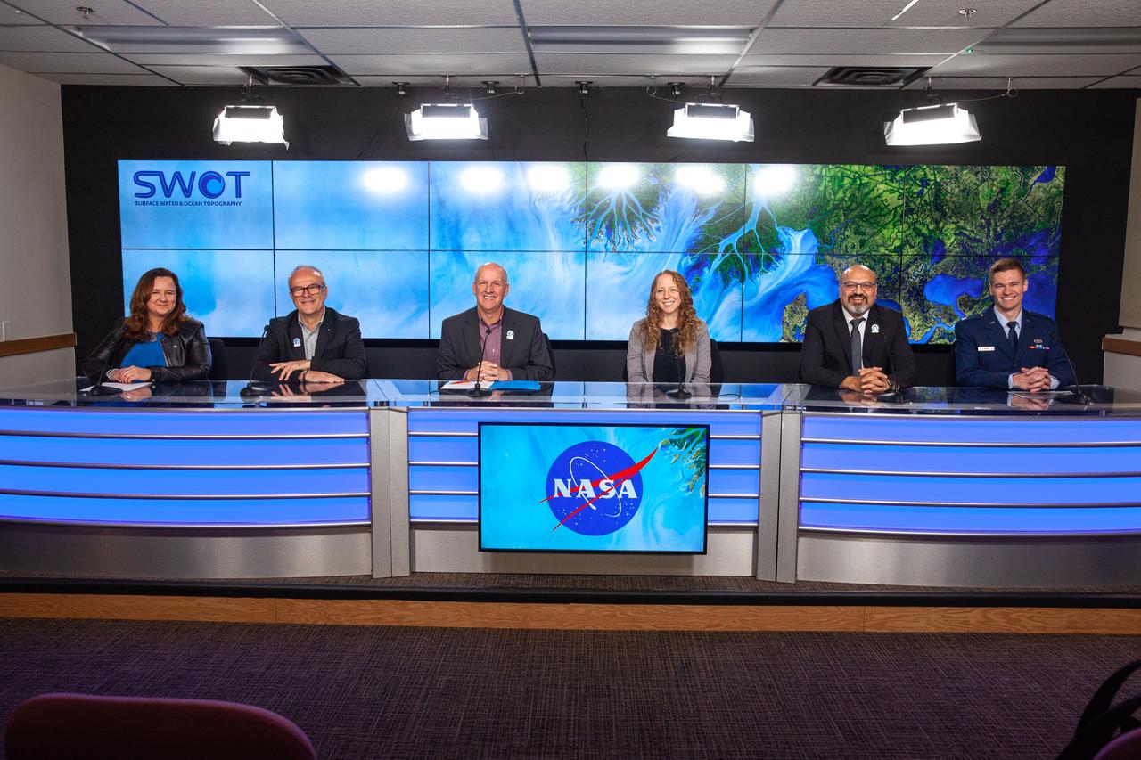
NASA, SpaceX, and the French space agency Centre National d’Études Spatiales (CNES) hold a prelaunch news conference for the Surface Water and Ocean Topography (SWOT) mission on Dec. 14, 2022, at Vandenberg Space Force Base in California. Participating from left are Karen St. Germain, Earth Science Division director, NASA; Thierry Lafon, SWOT project manager, CNES; Tim Dunn, launch director, NASA’s Launch Services Program; Julianna Scheiman, civil satellite missions director, SpaceX; Parag Vaze, SWOT project manager, Jet Propulsion Laboratory; Capt. Max Rush, launch weather officer, U.S. Air Force. SWOT is scheduled to launch on a SpaceX Falcon 9 rocket from Space Launch Complex-4 East at Vandenberg on Dec. 15, 2022, at 3:46 a.m. PST. SWOT will be NASA’s first global survey of nearly all water on Earth’s surface. Scientists plan to use its observations to better understand the global water cycle, furnish insight into the ocean’s role in how climate change unfolds, and provide a global inventory of water resources. The SWOT mission is a collaborative effort between NASA and CNES with contributions from the Canadian Space Agency and the UK Space Agency. NASA’s Launch Services Program, based at the agency’s Kennedy Space Center in Florida, is managing the launch service.
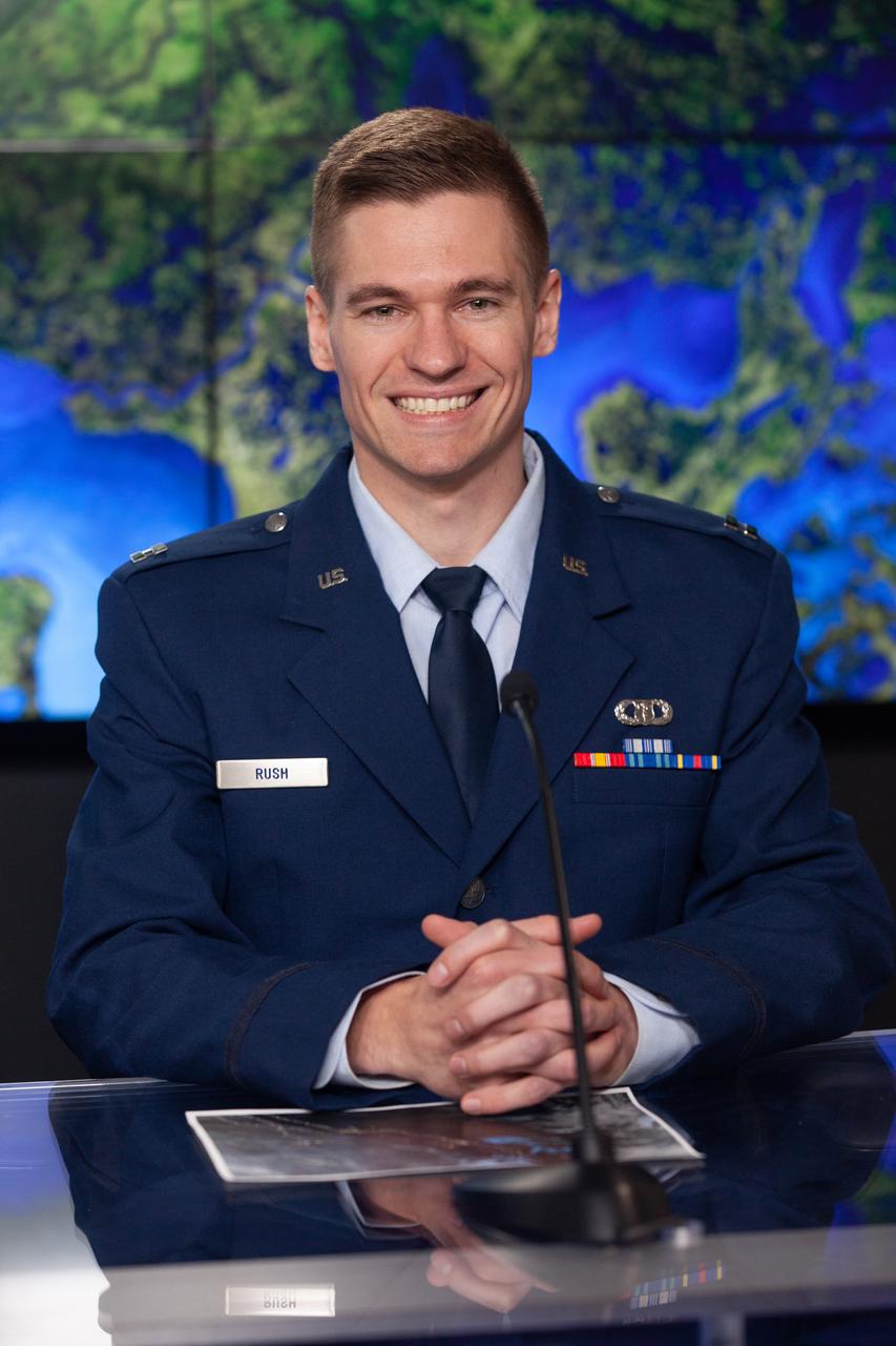
Capt. Max Rush, launch weather officer, U.S. Air Force, participates in a prelaunch news conference held by NASA, SpaceX, and the French space agency Centre National d’Études Spatiales (CNES) for the Surface Water and Ocean Topography (SWOT) mission on Dec. 14, 2022, at Vandenberg Space Force Base in California. SWOT is scheduled to launch on a SpaceX Falcon 9 rocket from Space Launch Complex-4 East at Vandenberg on Dec. 15, 2022, at 3:46 a.m. PST. SWOT will be NASA’s first global survey of nearly all water on Earth’s surface. Scientists plan to use its observations to better understand the global water cycle, furnish insight into the ocean’s role in how climate change unfolds, and provide a global inventory of water resources. The SWOT mission is a collaborative effort between NASA and CNES with contributions from the Canadian Space Agency and the UK Space Agency. NASA’s Launch Services Program, based at the agency’s Kennedy Space Center in Florida, is managing the launch service.

Federal, state, NASA, KSC and Space Florida Authority (SFA) officials dig in at the planned site of a multi-purpose hangar, phase one of the Reusable Launch Vehicle (RLV) Support Complex to be built near the Shuttle Landing Facility. From left, they are a representative from Rush Construction; Ed O'Connor, executive director of the Spaceport Florida Authority (SFA); Stephen T. Black, Lockheed Martin technical operations program manager; Warren Wiley, deputy director of engineering development; Tom Best, district director, representing U.S. Congressman Dave Weldon; Roy Bridges, director, Kennedy Space Center; Bill Posey, 32nd district representative; Randy Ball, state representative; Charlie Bronson, state senator; Donald McMonagle, manager of launch integration; and John London, Marshall Space Flight Center X-34 program manager. The new complex is jointly funded by SFA, NASA's Space Shuttle Program and Kennedy Space Center. It is intended to support the Space Shuttle and other RLV and X-vehicle systems. Completion is expected by the year 2000
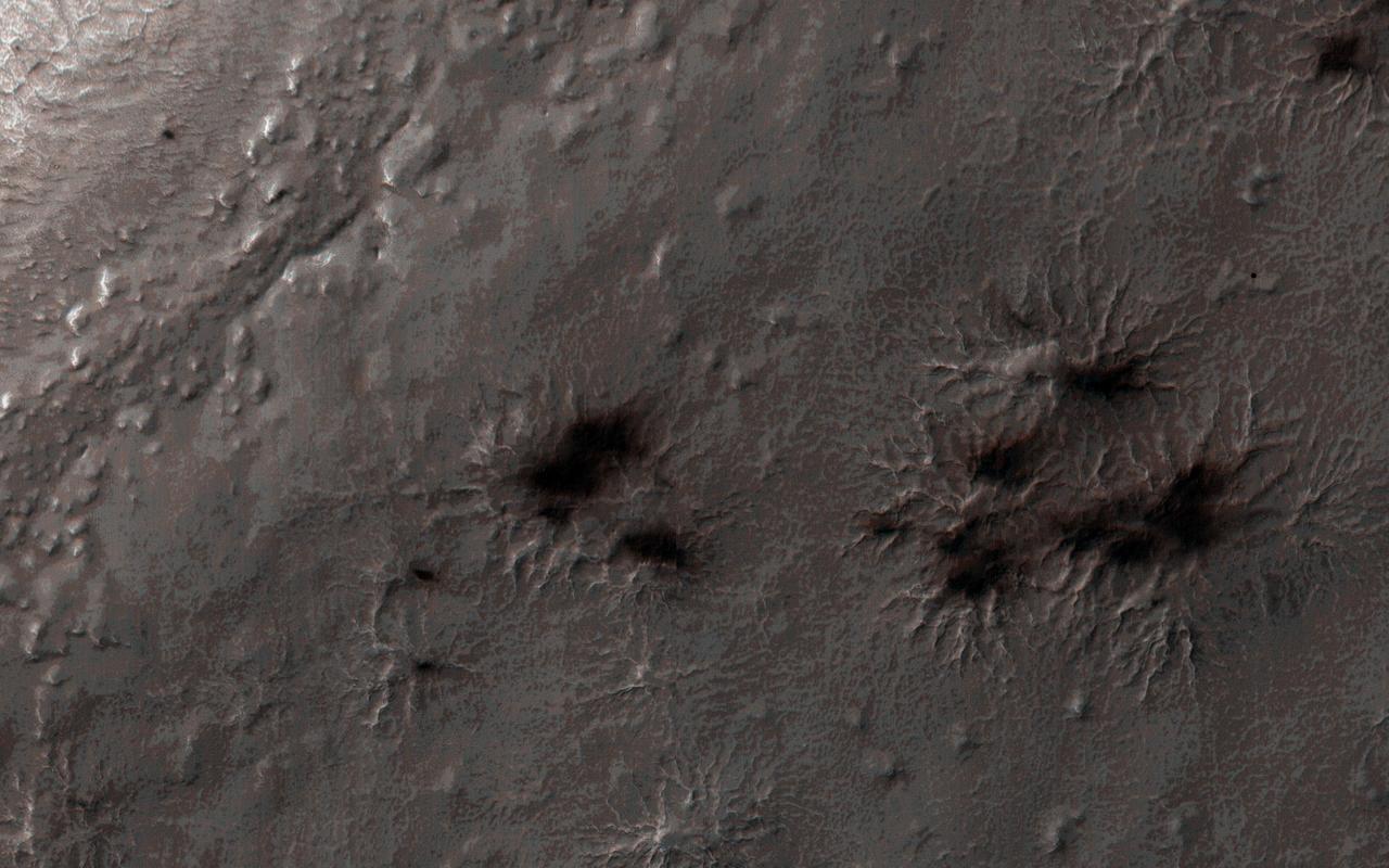
Every winter a layer of carbon dioxide ice-or, dry ice-condenses in the Southern polar region, forming a seasonal polar cap less than 1 meter deep. Early in the spring the ice layer begins to sublimate (going directly from a solid to gas) from the top and bottom of the ice layer. Under the ice gas pressure builds up until a weak spot in the ice layer ruptures. The gas rushes out and as it escapes it erodes a bit of the surface. Fine particles are carried by the gas to the top of the ice and then fall out in fan-shaped deposits. The direction of the fan shows the direction either of the wind or down the slope. If the wind is not blowing a dark blotch settles around the spot the gas escaped. This region is known informally as Inca City, and it has a series of distinctive ridges. On the floor between the ridges are radially organized channels, known colloquially as spiders, more formally called "araneiforms." The channels have been carved in the surface over many years by the escaping pressurized gas. Every spring they widen just a bit. This was the first image to be acquired by NASA Mars Reconnaissance Orbiter after the sun rose on Inca City, marking the end to polar night. A few fans are visible emerging from the araneiforms. http://photojournal.jpl.nasa.gov/catalog/PIA18892

On June 15, NASA's Swift caught the onset of a rare X-ray outburst from a stellar-mass black hole in the binary system V404 Cygni. Astronomers around the world are watching the event. In this system, a stream of gas from a star much like the sun flows toward a 10 solar mass black hole. Instead of spiraling toward the black hole, the gas accumulates in an accretion disk around it. Every couple of decades, the disk switches into a state that sends the gas rushing inward, starting a new outburst. Read more: <a href="http://www.nasa.gov/feature/goddard/nasa-missions-monitor-a-waking-black-hole" rel="nofollow">www.nasa.gov/feature/goddard/nasa-missions-monitor-a-waki...</a> Credits: NASA's Goddard Space Flight Center Download this video in HD formats from NASA Goddard's Scientific Visualization Studio <a href="http://svs.gsfc.nasa.gov/cgi-bin/details.cgi?aid=11110" rel="nofollow">svs.gsfc.nasa.gov/cgi-bin/details.cgi?aid=11110</a>
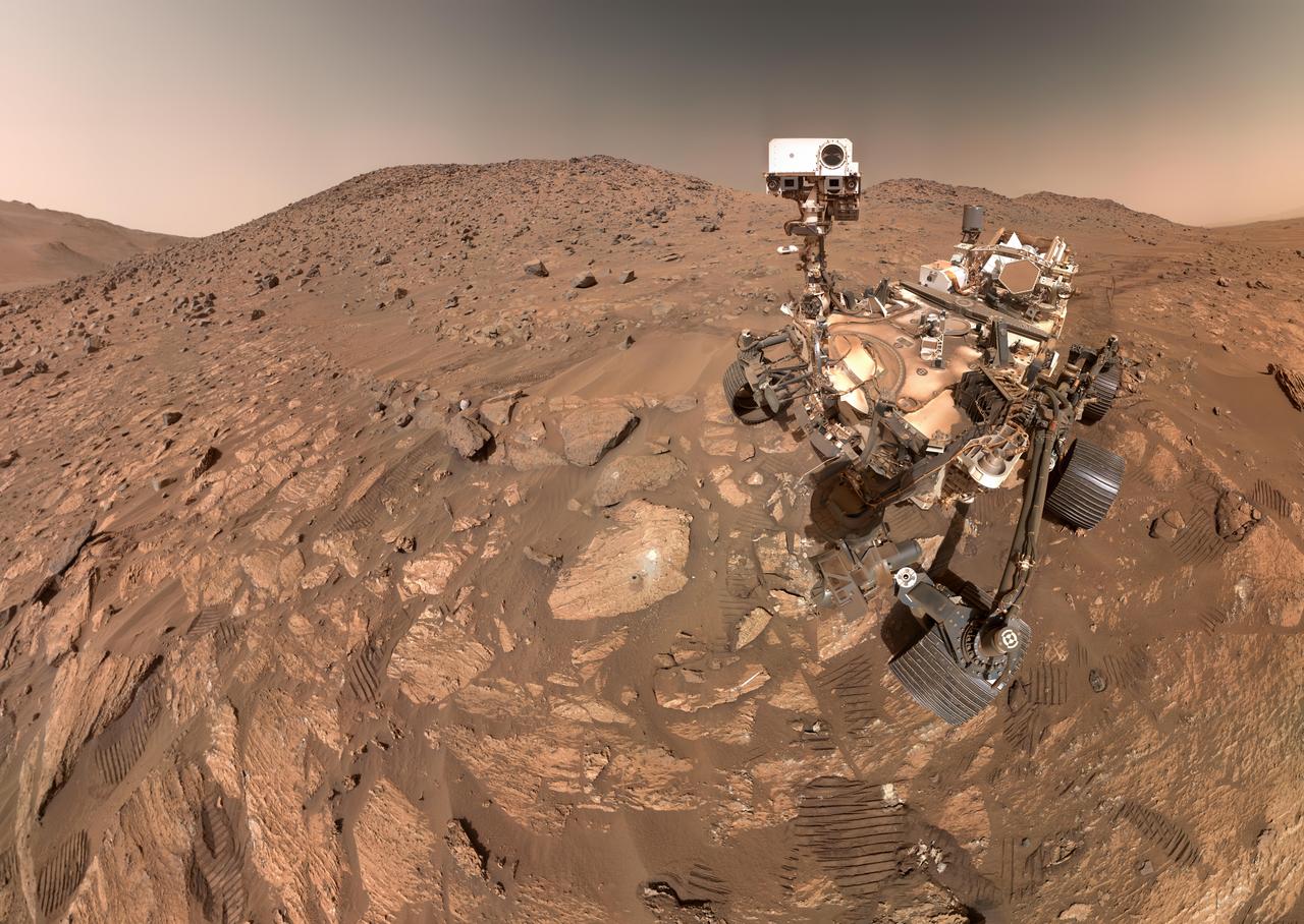
NASA's Perseverance Mars rover took this selfie on July 23, 2024, the 1,218th Martian day, or sol, of the mission. To the left of the rover near the center of the image is the arrowhead-shaped rock nicknamed "Cheyava Falls," which has features that may bear on the question of whether Mars was home to microscopic life in the distant past. The small dark hole in the rock is where Perseverance took a core sample, which is now in a sample tube stored in the rover's belly. The white patch to the right of the hole is where the rover used an abrasion tool to clear away the top surface, allowing science instruments to study the rock's composition. Measuring 3.2 feet by 2 feet (1 meter by 0.6 meters) and named after a Grand Canyon waterfall, Cheyava Falls lies at the northern edge of Neretva Vallis, an ancient river valley measuring a quarter-mile (400 meters) wide that was carved by water rushing into Jezero Crater long ago. The selfie is composed of 62 images taken by the WATSON (Wide Angle Topographic Sensor for Operations and eNgineering) camera on the end of the rover's robotic arm. The images were stitched together after being sent back to Earth. Animation available at https://photojournal.jpl.nasa.gov/catalog/PIA26344

This Chandra X-Ray Observatory image of the mysterious superstar Eta Carinae reveals a surprising hot irner core, creating more questions than answers for astronomers. The image shows three distinct structures: An outer, horseshoe shaped ring about 2 light-years in diameter, a hot inner core about 3 light-months in diameter, and a hot central source less than a light-month in diameter which may contain the superstar. In 1 month, light travels a distance of approximately 489 billion miles (about 788 billion kilometers). All three structures are thought to represent shock waves produced by matter rushing away from the superstar at supersonic speeds. The temperature of the shock-heated gas ranges from 60 million degrees Kelvin in the central regions to 7 million degrees Kelvin on the outer structure. Eta Carinae is one of the most enigmatic and intriguing objects in our galaxy. Between 1837 and 1856, it increased dramatically in brightness to become the most prominent star in the sky except for Sirius, even through it is 7,500 light-years away, more than 80 times the distance to Sirius. This "Great Eruption," as it is called, had an energy comparable to a supernova, yet did not destroy the star, which faded to become a dim star, invisible to the naked eye. Since 1940, Eta Carinae has begun to brighten again, becoming visible to the naked eye. Photo credit: NASA/CXC/SAO
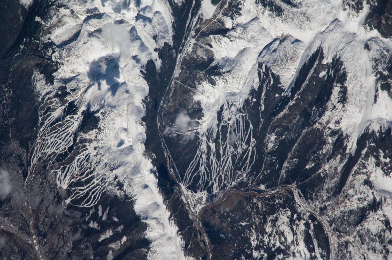
ISS018-E-005353 (24 Oct. 2008) --- Breckenridge and Copper Mountain ski slopes, Colorado are featured in this image photographed by an Expedition 18 crewmember on the International Space Station. Located in a section of the Rocky Mountains which extend through central Colorado, Tenmile Range and Copper Mountain provide the ideal location and landscape for popular winter sports. In this view, the Breckenridge and Copper Mountain ski areas are clearly visible as the snow covered ski runs stand out among the surrounding darker forest. Tenmile Range has mountain peaks that are named Peaks 1 through Peaks 10. The Breckenridge ski area use Peaks 7 through Peaks 10 which range from 12,631 feet (3,850 meters) to 13,615 feet (4,150 meters) high. Tenmile Canyon is a north northeast-trending fault-controlled valley running nearly 3,000 feet (914.4 meters) deep that serves as the boundaries for Tenmile Creek running through the center of the photo. The snow-covered peaks clearly delineate the tree line at an elevation of around 11,000 feet (3,350 meters). In the winter, this area's annual average snowfall ranges between 284 inches (7.21 meters) at Copper Mountain to 300 inches (7.62 meters) a year at Breckenridge. Before recreation became the main industry, miners were attracted to the area in the mid-1800's following discoveries of gold, silver, lead, and zinc. The towns of Breckenridge and Wheeler Junction (at the base of Copper Mountain ski area) were born out of the surge to settle the West during the Pike's Peak Gold Rush. While this image records snow on the peaks of Tenmile Range, the months of October and November 2008 saw little accumulation of snow pack in the area of Breckenridge. The situation changed in early December 2008 however, when more snow fell in eight days than in the preceding two months. The late, but significant, snowfall boosted the snow pack back to expected levels for this time of year.

A Fairchild C-82 Packet is purposely destroyed by researchers at the National Advisory Committee for Aeronautics (NACA) Lewis Flight Propulsion Laboratory. In response to an escalating number of transport aircraft crashes in the mid-1940s, the NACA researchers undertook a decade-long investigation into a number of issues surrounding low-altitude aircraft crashes. The tests were conducted at the Ravenna Arsenal, approximately 60 miles south of the Lewis laboratory in Cleveland, Ohio. The aircraft were excess military transports from World War II. The aircraft was guided down the runway at speeds of 80 to 105 miles per hour. It came into contact with poles which tore open the 1500-gallon fuel tanks in the wings before reaching the barriers at the end of the runway. Fuel poured from the tanks and supply lines, resulting in the spread of both liquid fuel and a large cloud of spray. Solomon Weiss developed a method of dying the fuel red to improve its visibility during the crashes. This red fuel cloud trailed slightly behind the skidding aircraft, then rushed forward when the aircraft stopped. The nine-crash initial phase of testing used Lockheed C-56 Lodestar and C-82 transport aircraft to identify potential ignition sources and analyze the spread of flammable materials. The researchers were able to identify different classes of ignition sources, fuel disbursement patterns, the time when a particular ignition source might appear, rate of the fire spread, cabin survival times, and deceleration rates.

In the 19th century, astronomer V. M. Slipher first discovered a hat-like object that appeared to be rushing away from us at 700 miles per second. This enormous velocity offered some of the earliest clues that it was really another galaxy, and that the universe was expanding in all directions. The trained razor sharp eye of the Hubble Space Telescope (HST) easily resolves this Sombrero galaxy, Messier 104 (M104). The galaxy is 50,000 light-years across and is located 28 million light-years from Earth at the southern edge of the rich Virgo cluster of galaxies. Equivalent to 800 billion suns, Sombrero is one of the most massive objects in that group. The hallmark of Sombrero is a brilliant white, bulbous core encircled by the thick dust lanes comprising the spiral structure of the galaxy. As seen from Earth, the galaxy is tilted nearly edge-on. We view it from just six degrees north of its equatorial plane. At a relatively bright magnitude of +8, M104 is just beyond the limit of naked-eye visibility and is easily seen through small telescopes. This rich system of globular clusters are estimated to be nearly 2,000 in number which is 10 times as many as in our Milky Way galaxy. The ages of the clusters are similar to the clusters in the Milky Way, ranging from 10-13 billion years old. Embedded in the bright core of M104 is a smaller disk, which is tilted relative to the large disk. X-ray emission suggests that there is material falling into the compact core, where a 1-billion-solar-mass black hole resides. The Marshall Space Flight Center (MSFC) had responsibility for design, development, and construction of the HST.
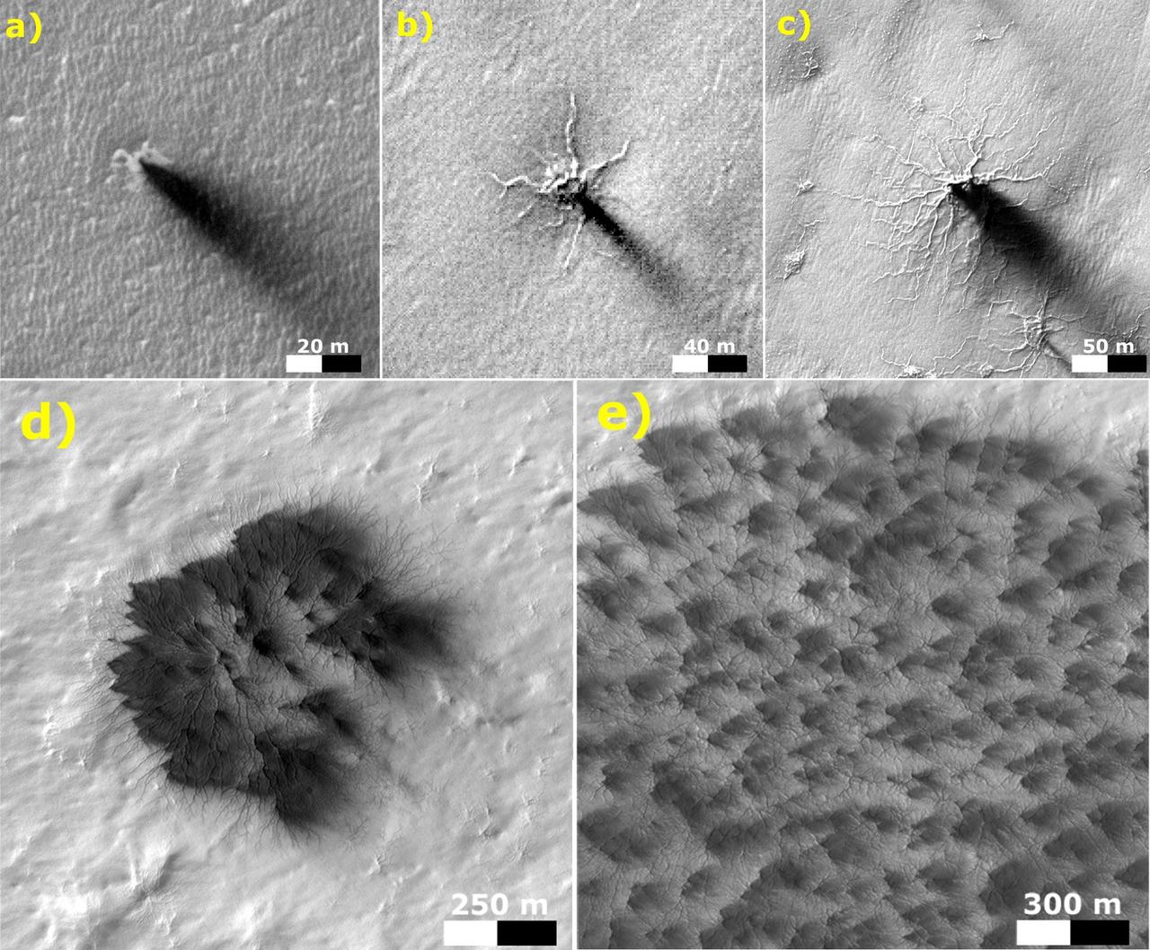
These five images from the High Resolution Imaging Science Experiment (HiRISE) camera on NASA's Mars Reconnaissance Orbiter show different Martian features of progressively greater size and complexity, all thought to result from thawing of seasonal carbon-dioxide ice that covers large areas near Mars' south pole during winter. The sequence illustrates possible stages in development of a type of Martian terrain called "araneiform," from Latin for spider-shaped. They range from a depression with one trough (upper left) to a broad network of "spiders" (lower right). Each image has a scale bar in meters, from 20 meters (66 feet) in the upper-left image to 300 meters (984 feet) in the lower-right one. Each image also includes dark "fans" that result from the same thawing process. Carbon-dioxide ice, better known as "dry ice," does not occur naturally on Earth. On Mars, sheets of it cover the ground during winter in areas near both poles, including the south-polar regions with spidery terrain. The dark fans appear in these areas each spring. Spring sunshine penetrates the ice to warm the ground underneath, causing some carbon dioxide on the bottom of the sheet to thaw into gas. The trapped gas builds pressure until a crack forms in the ice sheet. Gas erupts out, and gas beneath the ice rushes toward the vent, picking up particles of sand and dust. This erodes the ground and also supplies the geyser with particles that fall back to the surface, downwind, and appear as the dark spring fans. These five images are excerpts from HiRISE observations PSP_002718_0950, taken Feb. 24, 2007, at 85 degrees south latitude, 82 degrees east longitude, and ESP_011842_0980, taken Feb. 4, 2009, at 81 degrees south latitude, 76 degrees east longitude. http://photojournal.jpl.nasa.gov/catalog/PIA21258
Bruce A. Peterson standing beside the M2-F2 lifting body on Rogers Dry Lake. Peterson became the NASA project pilot for the lifting body program after Milt Thompson retired from flying in late 1966. Peterson had flown the M2-F1, and made the first glide flight of the HL-10 heavy-weight lifting body in December 1966. On May 10, 1967, Peterson made his fourth glide flight in the M2-F2. This was also the M2-F2's 16th glide flight, scheduled to be the last one before the powered flights began. However, as pilot Bruce Peterson neared the lakebed, the M2-F2 suffered a pilot induced oscillation (PIO). The vehicle rolled from side to side in flight as he tried to bring it under control. Peterson recovered, but then observed a rescue helicopter that seemed to pose a collision threat. Distracted, Peterson drifted in a cross-wind to an unmarked area of the lakebed where it was very difficult to judge the height over the lakebed because of a lack of the guidance the markers provided on the lakebed runway. Peterson fired the landing rockets to provide additional lift, but he hit the lakebed before the landing gear was fully down and locked. The M2-F2 rolled over six times, coming to rest upside down. Pulled from the vehicle by Jay King and Joseph Huxman, Peterson was rushed to the base hospital, transferred to March Air Force Base and then the UCLA Hospital. He recovered but lost vision in his right eye due to a staph infection.
The Aircraft Engine Research Laboratory’s first aircraft, a Martin B–26B Marauder, parked in front of the Flight Research Building in September 1943. The military loaned the B–26B to the National Advisory Committee for Aeronautics (NACA) to augment the lab’s studies of the Wright Aeronautical R–2800 engines. The military wanted to improve the engine cooling in order to increase the bomber’s performance. On March 17, 1943, the B–26B performed the very first research flight at the NACA’s new engine laboratory. The B–26B received its “Widowmaker” nickname during the rushed effort to transition the new aircraft from design to production and into the sky. During World War II, however, the B–26B proved itself to be a capable war machine. The U.S. lost fewer Marauders than any other type of bomber employed in the war. The B–26B was originally utilized at low altitudes in the Pacific but had its most success at high altitudes over Europe. The B–26B’s flight tests in Cleveland during 1943 mapped the R-2800 engine’s behavior at different altitudes and speeds. The researchers were then able to correlate engine performance in ground facilities to expected performance at different altitudes. They found that air speed, cowl flap position, angle of attack, propeller thrust, and propeller speed influenced inlet pressure recovery and exhaust distribution. The flight testing proceeded quickly, and the B–26B was transferred elsewhere in October 1943.
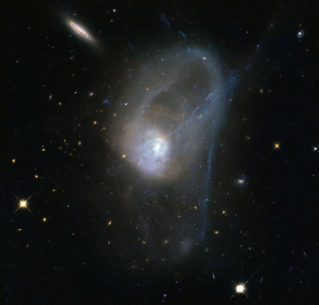
It is known today that merging galaxies play a large role in the evolution of galaxies and the formation of elliptical galaxies in particular. However there are only a few merging systems close enough to be observed in depth. The pair of interacting galaxies seen here — known as NGC 3921 — is one of these systems. NGC 3921 — found in the constellation of Ursa Major (The Great Bear) — is an interacting pair of disk galaxies in the late stages of its merger. Observations show that both of the galaxies involved were about the same mass and collided about 700 million years ago. You can see clearly in this image the disturbed morphology, tails and loops characteristic of a post-merger. The clash of galaxies caused a rush of star formation and previous Hubble observations showed over 1,000 bright, young star clusters bursting to life at the heart of the galaxy pair. Image credit: ESA/Hubble & NASA, Acknowledgement: Judy Schmidt <b><a href="http://www.nasa.gov/audience/formedia/features/MP_Photo_Guidelines.html" rel="nofollow">NASA image use policy.</a></b> <b><a href="http://www.nasa.gov/centers/goddard/home/index.html" rel="nofollow">NASA Goddard Space Flight Center</a></b> enables NASA’s mission through four scientific endeavors: Earth Science, Heliophysics, Solar System Exploration, and Astrophysics. Goddard plays a leading role in NASA’s accomplishments by contributing compelling scientific knowledge to advance the Agency’s mission. <b>Follow us on <a href="http://twitter.com/NASAGoddardPix" rel="nofollow">Twitter</a></b> <b>Like us on <a href="http://www.facebook.com/pages/Greenbelt-MD/NASA-Goddard/395013845897?ref=tsd" rel="nofollow">Facebook</a></b> <b>Find us on <a href="http://instagrid.me/nasagoddard/?vm=grid" rel="nofollow">Instagram</a></b>
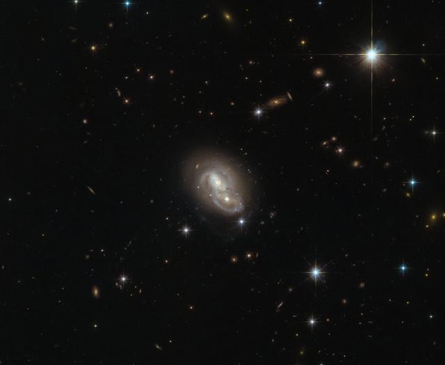
This image from the NASA/ESA Hubble Space Telescope shows the unusual galaxy IRAS 06076-2139, found in the constellation Lepus (The Hare). Hubble’s Wide Field Camera 3 (WFC3) and Advanced Camera for Surveys (ACS) instruments observed the galaxy from a distance of 500 million light-years. This particular object stands out from the crowd by actually being composed of two separate galaxies rushing past each other at about 2 million kilometers (1,243,000 miles) per hour. This speed is most likely too fast for them to merge and form a single galaxy. However, because of their small separation of only about 20,000 light-years, the galaxies will distort one another through the force of gravity while passing each other, changing their structures on a grand scale. Such galactic interactions are a common sight for Hubble, and have long been a field of study for astronomers. The intriguing behaviors of interacting galaxies take many forms; galactic cannibalism, galaxy harassment and even galaxy collisions. The Milky Way itself will eventually fall victim to the latter, merging with the Andromeda Galaxy in about 4.5 billion years. The fate of our galaxy shouldn’t be alarming though: while galaxies are populated by billions of stars, the distances between individual stars are so large that hardly any stellar collisions will occur. Credit: ESA/Hubble & NASA <b><a href="http://www.nasa.gov/audience/formedia/features/MP_Photo_Guidelines.html" rel="nofollow">NASA image use policy.</a></b> <b><a href="http://www.nasa.gov/centers/goddard/home/index.html" rel="nofollow">NASA Goddard Space Flight Center</a></b> enables NASA’s mission through four scientific endeavors: Earth Science, Heliophysics, Solar System Exploration, and Astrophysics. Goddard plays a leading role in NASA’s accomplishments by contributing compelling scientific knowledge to advance the Agency’s mission. <b>Follow us on <a href="http://twitter.com/NASAGoddardPix" rel="nofollow">Twitter</a></b> <b>Like us on <a href="http://www.facebook.com/pages/Greenbelt-MD/NASA-Goddard/395013845897?ref=tsd" rel="nofollow">Facebook</a></b> <b>Find us on <a href="http://instagrid.me/nasagoddard/?vm=grid" rel="nofollow">Instagram</a></b>
Derrol Nail, NASA Communications, moderates a prelaunch news conference for the agency’s Double Asteroid Redirection Test (DART) mission at Vandenberg Space Force Base in California on Nov. 22, 2021. DART is the first mission to test technologies for preventing an impact of Earth by a hazardous asteroid. The mission is scheduled to launch no earlier than 1:21 a.m. EST Wednesday, Nov. 24 (10:21 p.m. PST Tuesday, Nov. 23), aboard a SpaceX Falcon 9 rocket from Vandenberg. NASA's Launch Services Program based at Kennedy Space Center in Florida, America's multi-user spaceport, is managing the launch.

Thomas Zurbuchen, associate administrator for NASA’s Science Mission Directorate, participates in a prelaunch news conference for the agency’s Double Asteroid Redirection Test (DART) mission at Vandenberg Space Force Base in California on Nov. 22, 2021. DART is the first mission to test technologies for preventing an impact of Earth by a hazardous asteroid. The mission is scheduled to launch no earlier than 1:21 a.m. EST Wednesday, Nov. 24 (10:21 p.m. PST Tuesday, Nov. 23), aboard a SpaceX Falcon 9 rocket from Vandenberg. NASA's Launch Services Program based at Kennedy Space Center in Florida, America's multi-user spaceport, is managing the launch.
Omar Baez, senior launch director for NASA’s Launch Services Program, participates in a prelaunch news conference for the agency’s Double Asteroid Redirection Test (DART) mission at Vandenberg Space Force Base in California on Nov. 22, 2021. DART is the first mission to test technologies for preventing an impact of Earth by a hazardous asteroid. The mission is scheduled to launch no earlier than 1:21 a.m. EST Wednesday, Nov. 24 (10:21 p.m. PST Tuesday, Nov. 23), aboard a SpaceX Falcon 9 rocket from Vandenberg. NASA's Launch Services Program based at Kennedy Space Center in Florida, America's multi-user spaceport, is managing the launch.
Ed Reynolds, Double Asteroid Redirection Test (DART) project manager for Johns Hopkins Applied Physics Laboratory, participates in a prelaunch news conference for NASA’s DART mission at Vandenberg Space Force Base in California on Nov. 22, 2021. DART is the first mission to test technologies for preventing an impact of Earth by a hazardous asteroid. The mission is scheduled to launch no earlier than 1:21 a.m. EST Wednesday, Nov. 24 (10:21 p.m. PST Tuesday, Nov. 23), aboard a SpaceX Falcon 9 rocket from Vandenberg. NASA's Launch Services Program based at Kennedy Space Center in Florida, America's multi-user spaceport, is managing the launch.
Lindley Johnson, planetary defense officer for NASA’s Planetary Defense Coordination Office, participates in a prelaunch news conference for the agency’s Double Asteroid Redirection Test (DART) mission at Vandenberg Space Force Base in California on Nov. 22, 2021. DART is the first mission to test technologies for preventing an impact of Earth by a hazardous asteroid. The mission is scheduled to launch no earlier than 1:21 a.m. EST Wednesday, Nov. 24 (10:21 p.m. PST Tuesday, Nov. 23), aboard a SpaceX Falcon 9 rocket from Vandenberg. NASA's Launch Services Program based at Kennedy Space Center in Florida, America's multi-user spaceport, is managing the launch.

Julianna Scheiman, director for civil satellite missions for SpaceX, participates in a prelaunch news conference for NASA’s Double Asteroid Redirection Test (DART) mission at Vandenberg Space Force Base in California on Nov. 22, 2021. DART is the first mission to test technologies for preventing an impact of Earth by a hazardous asteroid. The mission is scheduled to launch no earlier than 1:21 a.m. EST Wednesday, Nov. 24 (10:21 p.m. PST Tuesday, Nov. 23), aboard a SpaceX Falcon 9 rocket from Vandenberg. NASA's Launch Services Program based at Kennedy Space Center in Florida, America's multi-user spaceport, is managing the launch.
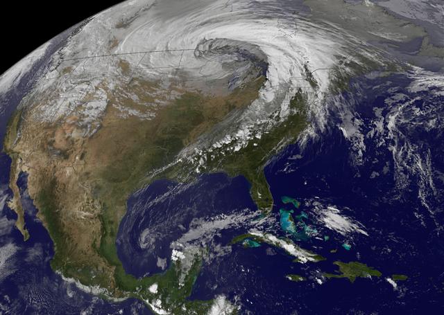
NASA image acquired October 26, 2010 The storm that swept across the center of the United States on October 26 and October 27, 2010, was memorable to those who experienced it because of its strong winds, rain, hail, and widespread tornadoes. Meteorologists get excited about the storm because it set a record for the lowest pressure (not associated with a hurricane) measured over land in the continental United States. At 5:13 p.m. CDT, the weather station in Bigfork, Minnesota recorded 955.2 millibars (28.21 inches of pressure). Pressure is one indicator of a storm’s strength, and this measurement corresponds to the pressure seen in a Category 3 hurricane. This image, taken by the GOES satellite on October 26, shows the storm system circling around the area of extreme low pressure. Such extratropical cyclones form over the United States in the spring and fall, when the temperature difference from north to south is large. Warm, high-pressure air rushes toward the cooler, low-pressure air in the north. Because the Earth is rotating, the air moving in ends up circling the area of low pressure, creating the cyclone shown in the image. The intensity of the storm is determined by the pressure difference between the center and the outer edges. Extreme low pressure in the center of the storm, therefore, is an indicator that the storm was very intense. The animation shows the storm developing starting late on October 25 and running through October 27. The cyclone formed very quickly on October 26, taking a distinctive comma shape as the day went on. The storm developed so quickly, in fact, that it is classified as a bomb, an extremely fast developing storm (dropping at least one millibar of pressure per hour for 24 hours), more common over water than land. The storm was also huge. Though the area of low pressure is centered over the Upper Midwest, the storm reached from the Gulf of Mexico into Canada, and from the Rocky Mountains to the Atlantic Ocean. Extratropical cyclones bring an array of unsettled weather, including strong wind, rain, hail, and tornadoes, and this cyclone brought all of that. On October 26–27, winds gusted up to 78 miles per hour in Michigan, with high winds throughout the Midwest. The National Weather Service reported 61 tornadoes over the two days. Heavy snow also fell in the north. NASA Earth Observatory imagery created by Jesse Allen, using imagery provided courtesy of the NASA GOES Project Science Office. Caption by Holli RIebeek. Instrument: GOES Credit: <b><a href="http://www.earthobservatory.nasa.gov/" rel="nofollow"> NASA Earth Observatory</a></b> <b><a href="http://www.nasa.gov/centers/goddard/home/index.html" rel="nofollow">NASA Goddard Space Flight Center</a></b> enables NASA’s mission through four scientific endeavors: Earth Science, Heliophysics, Solar System Exploration, and Astrophysics. Goddard plays a leading role in NASA’s accomplishments by contributing compelling scientific knowledge to advance the Agency’s mission. <b>Follow us on <a href="http://twitter.com/NASA_GoddardPix" rel="nofollow">Twitter</a></b> <b>Join us on <a href="http://www.facebook.com/pages/Greenbelt-MD/NASA-Goddard/395013845897?ref=tsd" rel="nofollow">Facebook</a></b>
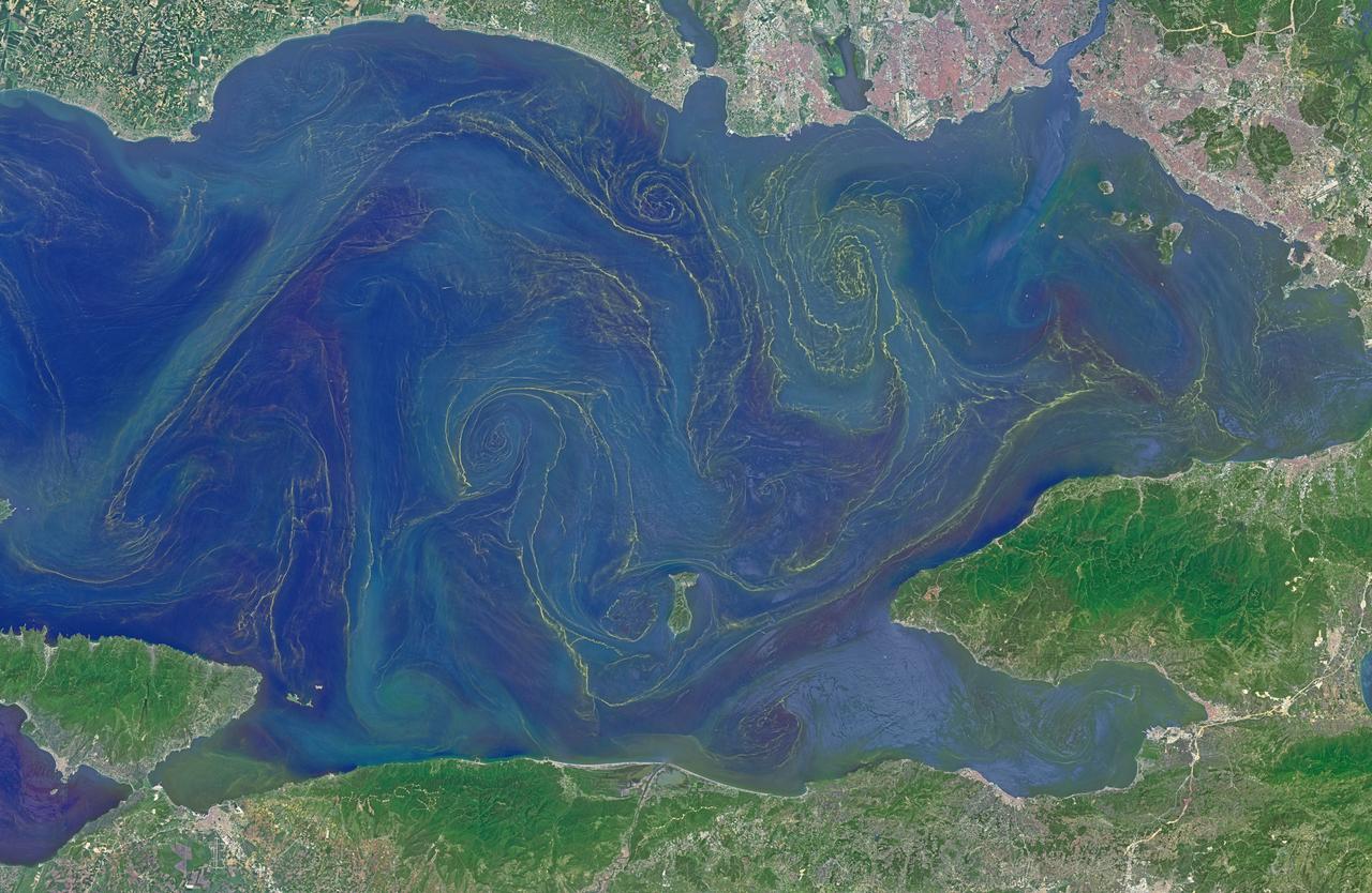
Situated between the Black Sea and the Aegean Sea, the Sea of Marmara is full of a rich soup of nutrients and life and surrounded by a rich history of civilization. Like the Black Sea to its northeast, the Marmara has an unusual layered structure with fresher water near the surface and much saltier water near the bottom. That fresh surface is fed by exchanges with the Black Sea and by flows from the Susurluk, Biga, and Gonen Rivers. The fresh water (just two thirds the salinity of the ocean) makes it easier for floating, plant-like organisms—phytoplankton—to grow, as does the abundance of nutrients pouring into the seas from European and Turkish rivers. The Operational Land Imager on the Landsat 8 satellite captured this image of a phytoplankton bloom in the Sea of Marmara on May 17, 2015. The sea is surrounded on all sides by the nation of Turkey. The swirling shapes on the water are phytoplankton, with the yellow-green and red-purple filaments likely (but not necessarily) representing different species. Those wavy colored lines not only show where the densest concentrations of plankton are floating, but also reveal the eddies and currents within the small sea. Waters rushing in through the narrow Bosphorous Strait (at Istanbul) and Dardanelles Strait (off the left side of the image), as well as a jagged coastline and tectonically fractured seafloor on this edge of the Asian and European continents, all conspire to create intricate mixing patterns. If you download the large image and open it in full resolution, you also can see ship tracks crossing the bloom lines. “I often see features in imagery and wonder: what could be causing that?” said Norman Kuring, an ocean color specialist at NASA Goddard. “Remote sensing is great for the big picture, but it still needs data from the surface for validation and interpretation.” According to scientists Baris Salihoglu of Turkey’s Institute of Marine Sciences and Ahsen Yuksek of Istanbul University, the blooms in the satellite image are mostly Prorocentrum micans and Noctiluca scintillans. They recently sampled the waters of the Marmara and found that Prorocentrum bloomed first, though Noctiluca eventually dominated. According to Ajit Subramaniam of the Lamont Doherty Earth Observatory, both species are dinoflagellates, known to discolor the water (red tides). Neither is directly toxic to humans, but they can kill marine life by becoming caught in fish gills, depleting the sea of oxygen, or excreting ammonia into the water. “Noctiluca is phagotrophic—a really interesting beast since it eats other phytoplankton that can then change its color,” Subramaniam noted. “It switches from being photosynthetic to becoming heterotrophic.” The Moderate Resolution Imaging Spectroradiometer (MODIS) on NASA’s Terra satellite captured wider views of bloom events in the Sea of Marmara on on May 23 and May 25. Credit: <b><a href="http://www.earthobservatory.nasa.gov/" rel="nofollow"> NASA Earth Observatory</a></b> Read more: <a href="http://earthobservatory.nasa.gov/IOTD/view.php?id=85947" rel="nofollow">earthobservatory.nasa.gov/IOTD/view.php?id=85947</a> <b><a href="http://www.nasa.gov/audience/formedia/features/MP_Photo_Guidelines.html" rel="nofollow">NASA image use policy.</a></b> <b><a href="http://www.nasa.gov/centers/goddard/home/index.html" rel="nofollow">NASA Goddard Space Flight Center</a></b> enables NASA’s mission through four scientific endeavors: Earth Science, Heliophysics, Solar System Exploration, and Astrophysics. Goddard plays a leading role in NASA’s accomplishments by contributing compelling scientific knowledge to advance the Agency’s mission. <b>Follow us on <a href="http://twitter.com/NASAGoddardPix" rel="nofollow">Twitter</a></b> <b>Like us on <a href="http://www.facebook.com/pages/Greenbelt-MD/NASA-Goddard/395013845897?ref=tsd" rel="nofollow">Facebook</a></b> <b>Find us on <a href="http://instagrid.me/nasagoddard/?vm=grid" rel="nofollow">Instagram</a></b>

NASA image acquired August 27, 2009 Like rivers of liquid water, glaciers flow downhill, with tributaries joining to form larger rivers. But where water rushes, ice crawls. As a result, glaciers gather dust and dirt, and bear long-lasting evidence of past movements. Alaska’s Susitna Glacier revealed some of its long, grinding journey when the Advanced Spaceborne Thermal Emission and Reflection Radiometer (ASTER) on NASA’s Terra satellite passed overhead on August 27, 2009. This satellite image combines infrared, red, and green wavelengths to form a false-color image. Vegetation is red and the glacier’s surface is marbled with dirt-free blue ice and dirt-coated brown ice. Infusions of relatively clean ice push in from tributaries in the north. The glacier surface appears especially complex near the center of the image, where a tributary has pushed the ice in the main glacier slightly southward. A photograph taken by researchers from the U.S. Geological Survey (archived by the National Snow and Ice Data Center) shows an equally complicated Susitna Glacier in 1970, with dirt-free and dirt-encrusted surfaces forming stripes, curves, and U-turns. Susitna flows over a seismically active area. In fact, a 7.9-magnitude quake struck the region in November 2002, along a previously unknown fault. Geologists surmised that earthquakes had created the steep cliffs and slopes in the glacier surface, but in fact most of the jumble is the result of surges in tributary glaciers. Glacier surges—typically short-lived events where a glacier moves many times its normal rate—can occur when melt water accumulates at the base and lubricates the flow. This water may be supplied by meltwater lakes that accumulate on top of the glacier; some are visible in the lower left corner of this image. The underlying bedrock can also contribute to glacier surges, with soft, easily deformed rock leading to more frequent surges. NASA Earth Observatory image created by Jesse Allen and Robert Simmon, using data provided courtesy of NASA/GSFC/METI/ERSDAC/JAROS, and U.S./Japan ASTER Science Team. Caption by Michon Scott. Instrument: Terra - ASTER Credit: <b><a href="http://www.earthobservatory.nasa.gov/" rel="nofollow"> NASA Earth Observatory</a></b> <b><a href="http://www.nasa.gov/centers/goddard/home/index.html" rel="nofollow">NASA Goddard Space Flight Center</a></b> enables NASA’s mission through four scientific endeavors: Earth Science, Heliophysics, Solar System Exploration, and Astrophysics. Goddard plays a leading role in NASA’s accomplishments by contributing compelling scientific knowledge to advance the Agency’s mission. <b>Follow us on <a href="http://twitter.com/NASA_GoddardPix" rel="nofollow">Twitter</a></b> <b>Join us on <a href="http://www.facebook.com/pages/Greenbelt-MD/NASA-Goddard/395013845897?ref=tsd" rel="nofollow">Facebook</a></b>