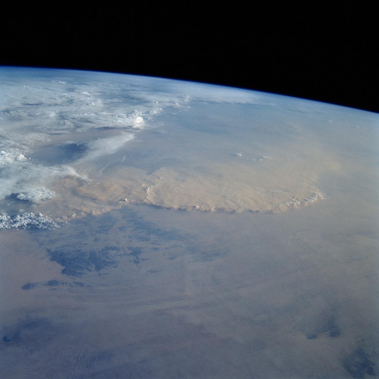
STS049-92-071 (13 May 1992) --- The STS-49 crew aboard the Earth-orbiting Space Shuttle Endeavour captured this Saharan dust storm on the Algeria-Niger border. The south-looking, late-afternoon view shows one of the best examples in the Shuttle photo data base of a dust storm. A series of gust fronts, caused by dissipating thunderstorms have picked up dust along the outflow boundaries. Small cumulus clouds have formed over the most vigorously ascending parts of the dust front, enhancing the visual effect of the front. The storm is moving roughly north-northwest, at right angles to the most typical path for dust storms in this part of the Sahara (shown by lines of sand on the desert surface in the foreground). Storms such as this can move out into the Atlantic, bringing dust even as far as the Americas on some occasions. A crewmember used a 70mm handheld Hasselblad camera with a 100mm lens to record the frame.
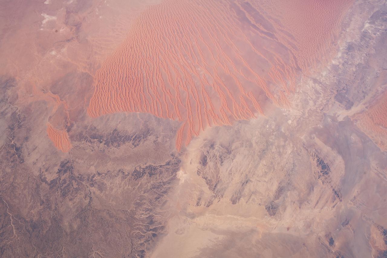
STS054-152-189 (13-19 Jan. 1993) --- This near-vertical color photograph shows the very diverse landscape that is part of the great Sahara Desert of north Africa. Specifically, the vast expanse of sand dunes, located in the extreme southwestern corner of Libya, is known as the Murzuk Sand Sea. Close inspection of this photograph shows the agricultural village of Murzuk as evidenced by the numerous center pivot irrigation patterns at the edge of the Murzuk Sand Sea. The very rugged, dissected terrain to the west of this sand sea is the eastern tip of the Tassili N'ajjer Mountains and the Tadrart Plateau that are in neighboring Algeria. Several smaller areas of sand dunes are interspersed between the major areas of rock outcrops. The photograph was taken with a Linhof camera.
iss063e002389 (April 22, 2020) --- The northern central portion of Morocco, pictured from the International Space Station, is a mountainous region that borders the Sahara Desert in northwest Africa.
iss060e014846 (July 26, 2019) --- A portion of the Sahara desert in Algeria is pictured as the International Space Station orbited 260 miles above north Africa.
iss060e014847 (July 26, 2019) --- A portion of the Sahara desert in Algeria is pictured as the International Space Station orbited 260 miles above north Africa.
iss067e141205 (June 19, 2022) --- This portion of the Western Desert is an area of the Sahara where the borders of Egypt, Libya, and Sudan meet. The International Space Station was orbiting 259 miles above north Africa at the time of this photograph.
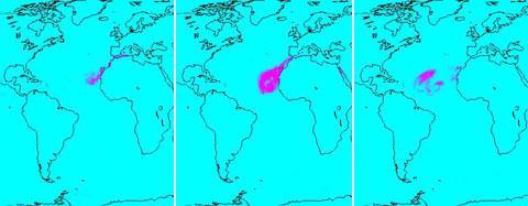
In July of 2005, a continent-sized cloud of hot air and dust originating from the Sahara Desert crossed the Atlantic Ocean and headed towards Florida and the Caribbean, captured by the Atmospheric Infrared Sounder onboard NASA Aqua satellite. A Saharan Air Layer, or SAL, forms when dry air and dust rise from Africa's west coast and ride the trade winds above the Atlantic Ocean. These dust clouds are not uncommon, especially during the months of July and August. They start when weather patterns called tropical waves pick up dust from the desert in North Africa, carry it a couple of miles into the atmosphere and drift westward. http://photojournal.jpl.nasa.gov/catalog/PIA00448
Africa's Lake Chad where the borders of Chad, Niger, Nigeria and Cameroon merge (13.0N, 14.0E) has been undergoing change for the past 25 to 30 years when it was first noticed that the lake is drying up. Since then, astronauts have been photographing it on a regular basis to record the diminishing lake bed. This lake was once the aproximate size of Lake Erie but is now only about half that size and is still receeding.
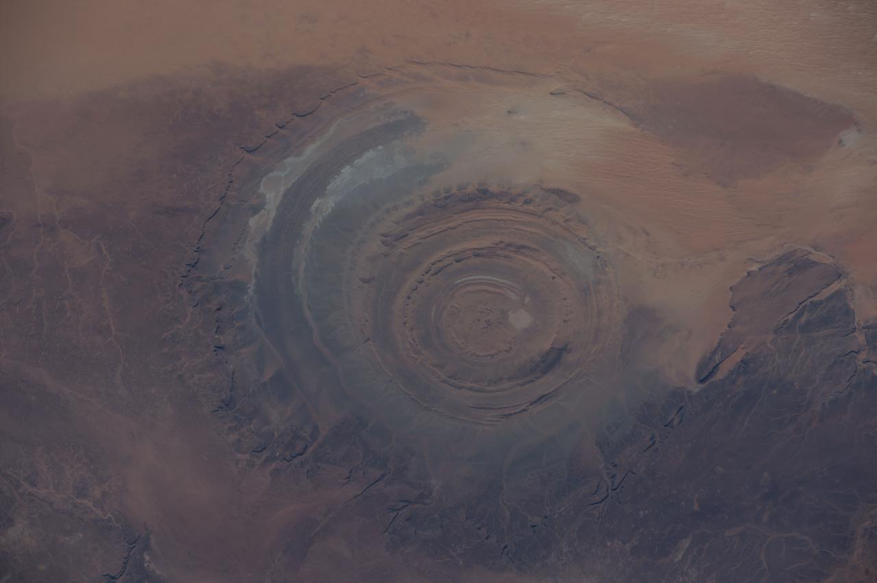
ISS042E007131 (11/22/2014) — Astronauts aboard the International Space Station captured this image of a huge crater in Africa on Nov. 22, 2014. This is the Richat Structure in northwestern Mauritania, otherwise known as the “Eye of the Sahara.” Scientists are still deciding whether this was formed by a subterranean volcano or impact from a large meteor. Deep in the Sahara Desert it is nearly a perfect circle, it is 1.2 miles (1.9 kilometers) wide, and sports a rim 330 feet (100 meters) tall. The crater sits in a vast plain of rocks so ancient they were deposited hundreds of millions of years before the first dinosaurs walked the Earth.
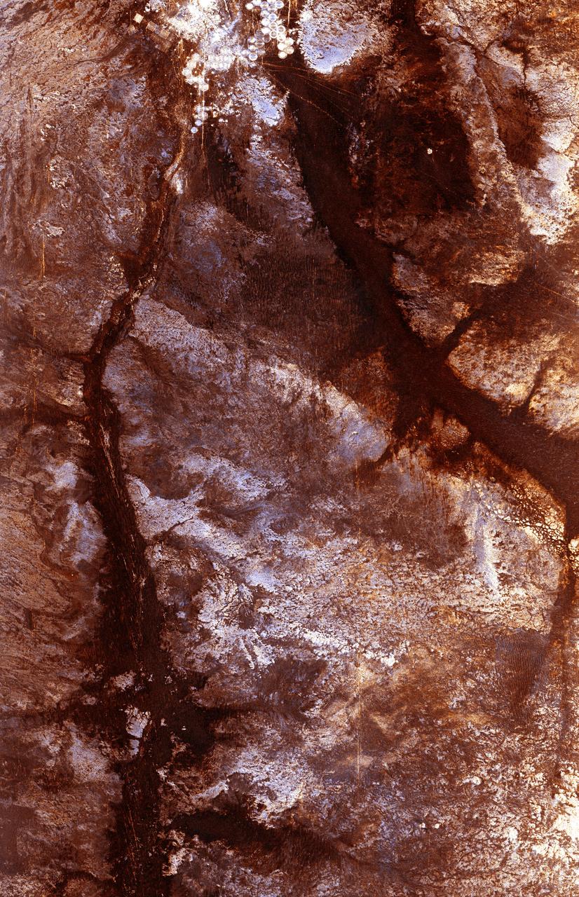
STS062-151-182Z (4-18 March 1994) --- This east-looking view shows most of the east-west extent of the country of Sudan. The foreground shows a vegetation-less and almost uninhabited region of northwest Sudan. The rich earth colors are ancient soils (browner and redder tones), a concentrated mass of what may be volcanic cinder cones (dark brown dots - center) and dune and younger river sediments (yellows). The photo would have been difficult to locate had it not been for two recognizable features in the background: a visually well-known inselberg ("island mountain" -- top center) on a large west-bank tributary of the White Nile; and the confluence of the Blue and White Nile's, with the great cotton developments of the Gezira Scheme between them (top left). The Red Sea coast is almost obscured by a dust cloud but can be discerned running across the top of the picture. The clouds at top may be developing over the coastal ranges of Saudi Arabia beyond the Red Sea.

AS08-16-2588 (21-27 Dec. 1968) --- Both sides of the Atlantic Ocean are visible in this view from Apollo 8 spacecraft. (Hold picture with Earth at bottom left). The large, most prominent land mass is the bulge of West Africa. The portion of Africa near the equator is dark and cloudy, but the more northerly portions are clear, showing the prominent cape at Dakar and the Senegal River in Senegal; Cap Blanc; the Adrar Plateau in Mauretania; the wide expanse of desert in Algeria and Spanish Sahara; and the far edge, the Atlas and Anti-Atlas Mountains in Morocco. Clouds cover the eastern coast of South America, southward from Surinam and Guyana to near the city of Salvador, Brazil. The view was photographed following trans-lunar insertion.
In December 2016, snow fell in the Sahara for the first time since 1979. In 1984, the charitable supergroup Band Aid sang: “There won’t be snow in Africa this Christmas time.” In fact, it does snow in Africa at high elevations. Kilimanjaro has long had a cap of snow and ice, though it has been shrinking. Skiiers travel for natural and manufactured snow in the Atlas Mountains of Morocco and Algeria, as well as a few spots in South Africa and Lesotho. Nonetheless, snow on the edge of the Sahara Desert is rare. On December 19, 2016, snow fell on the Algerian town of Ain Sefra, which is sometimes referred to as the “gateway to the desert.” The town of roughly 35,000 people sits between the Atlas Mountains and the northern edge of the Sahara. The last recorded snowfall in Ain Sefra occurred in February 1979. The Enhanced Thematic Mapper Plus (ETM+) on the Landsat 7 satellite acquired this natural-color image of snow in North Africa on December 19, 2016. This scene shows an area near the border of Morocco and Algeria, south of the city of Bouarfa and southwest of Ain Sefra. Though the news has been dominated by snow in the Saharan city, a review of several years of satellite data suggests that snow is also pretty rare in this section of the Atlas range. Read more: <a href="http://go.nasa.gov/2hIH4Xe" rel="nofollow">go.nasa.gov/2hIH4Xe</a> NASA Earth Observatory image by Joshua Stevens, using Landsat data from the U.S. Geological Survey. Caption by Mike Carlowicz. b><a href="http://www.nasa.gov/audience/formedia/features/MP_Photo_Guidelines.html" rel="nofollow">NASA image use policy.</a> <b><a href="http://www.nasa.gov/centers/goddard/home/index.html" rel="nofollow">NASA Goddard Space Flight Center</a></b> enables NASA’s mission through four scientific endeavors: Earth Science, Heliophysics, Solar System Exploration, and Astrophysics. Goddard plays a leading role in NASA’s accomplishments by contributing compelling scientific knowledge to advance the Agency’s mission. <b>Follow us on <a href="http://twitter.com/NASAGoddardPix" rel="nofollow">Twitter</a></b> <b>Like us on <a href="http://www.facebook.com/pages/Greenbelt-MD/NASA-Goddard/395013845897?ref=tsd" rel="nofollow">Facebook</a></b> <b>Find us on <a href="http://instagrid.me/nasagoddard/?vm=grid" rel="nofollow">Instagram</a></b>
What connects Earth's largest, hottest desert to its largest tropical rainforest? The Sahara Desert is a near-uninterrupted brown band of sand and scrub across the northern third of Africa. The Amazon rainforest is a dense green mass of humid jungle that covers northeast South America. But after strong winds sweep across the Sahara, a tan cloud rises in the air, stretches between the continents, and ties together the desert and the jungle. It’s dust. And lots of it. For the first time, a NASA satellite has quantified in three dimensions how much dust makes this trans-Atlantic journey. Scientists have not only measured the volume of dust, they have also calculated how much phosphorus – a natural plant fertilizer present in Saharan sands from part of the desert’s past as a lake bed – gets carried across the ocean from one of the planet’s most desolate places to one of its most fertile. <b><a href="http://www.nasa.gov/audience/formedia/features/MP_Photo_Guidelines.html" rel="nofollow">NASA image use policy.</a></b> <b><a href="http://www.nasa.gov/centers/goddard/home/index.html" rel="nofollow">NASA Goddard Space Flight Center</a></b> enables NASA’s mission through four scientific endeavors: Earth Science, Heliophysics, Solar System Exploration, and Astrophysics. Goddard plays a leading role in NASA’s accomplishments by contributing compelling scientific knowledge to advance the Agency’s mission. <b>Follow us on <a href="http://twitter.com/NASAGoddardPix" rel="nofollow">Twitter</a></b> <b>Like us on <a href="http://www.facebook.com/pages/Greenbelt-MD/NASA-Goddard/395013845897?ref=tsd" rel="nofollow">Facebook</a></b> <b>Find us on <a href="http://instagram.com/nasagoddard?vm=grid" rel="nofollow">Instagram</a></b>
The ability of a sophisticated radar instrument to image large regions of the world from space, using different frequencies that can penetrate dry sand cover, produced the discovery in this image: a previously unknown branch of an ancient river, buried under thousands of years of windblown sand in a region of the Sahara Desert in North Africa. This area is near the Kufra Oasis in southeast Libya, centered at 23.3 degrees north latitude, 22.9 degrees east longitude. The image was acquired by the Spaceborne Imaging Radar-C/X-band Synthetic Aperture (SIR-C/X-SAR) imaging radar when it flew aboard the space shuttle Endeavour on its 60th orbit on October 4, 1994. This SIR-C image reveals a system of old, now inactive stream valleys, called "paleodrainage systems, http://photojournal.jpl.nasa.gov/catalog/PIA01310
ISS032-E-008976 (15 July 2012) --- Saharan dust reaching the Americas is featured in this image photographed by an Expedition 32 crew member on the International Space Station. Weather satellites frequently document major dust palls blowing from the Sahara Desert westward from Africa out into the tropical Atlantic Ocean. Space station crew members frequently see these Saharan dust masses as very widespread atmospheric haze. Dust palls blowing from Africa can be transported right across the Atlantic Ocean. It takes about a week to reach either North America (in northern hemisphere summer) or South America (in northern hemisphere winter). This puts the Caribbean basin on the receiving end of many of these events. Recently, researchers have linked Saharan dust to coral disease, allergic reactions in humans, and red tides. The margin of the hazy air in this image reaches as far as Haiti (top center) and the nearby Turks and Caicos Islands (top left) ? but the eastern tip of Cuba in the foreground remains in the clear air.
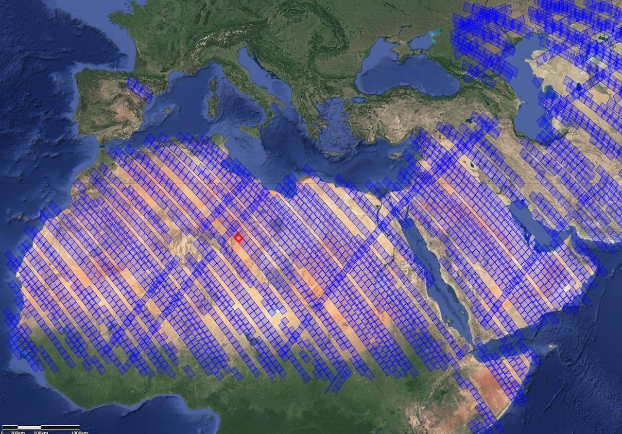
This image shows locations in parts of North Africa, Europe, the Middle East, and Central Asia observed by NASA's Earth Surface Mineral Dust Source Investigation (EMIT). Each blue box is a "scene" the instrument, which is aboard the International Space Station, has captured. The red box indicates where the instrument recently gathered data on three minerals in a location in southwest Libya, in the Sahara Desert. Installed on the space station in July 2022, EMIT orbits Earth about once every 90 minutes to map the world's mineral-dust sources, gathering information about surface composition as the instrument completes about 16 orbits per day. Over the course of its 12-month mission, EMIT will collect measurements of 10 important surface minerals – kaolinite, hematite, goethite, illite, vermiculite, calcite, dolomite, montmorillonite, chlorite, and gypsum – in arid regions between 50-degree south and north latitudes in Africa, Asia, North and South America, and Australia. The data EMIT collects will help scientists better understand the role of airborne dust particles in heating and cooling Earth's atmosphere on global and regional scales. https://photojournal.jpl.nasa.gov/catalog/PIA25429
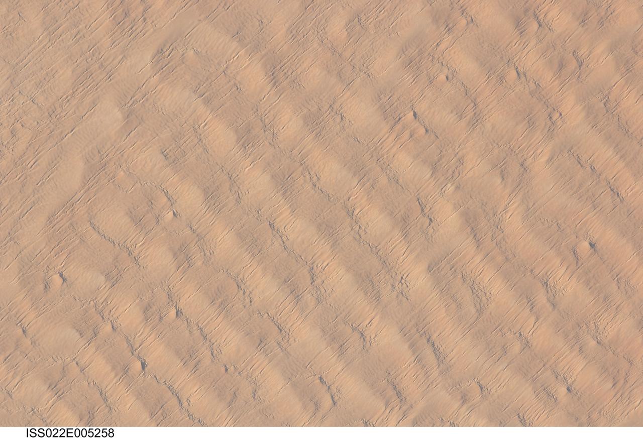
ISS022-E-005258 (1 Dec. 2009) --- This detailed hand-held digital camera?s image recorded from the International Space Station highlights sand dunes in the Fachi-Bilma erg, or sand sea, which is part of the central eastern Tenere Desert. The Tenere occupies much of southeastern Niger and is considered to be part of the larger Sahara Desert that stretches across northern Africa. Much of the Sahara is comprised of ergs ? with an area of approximately 150,000 square kilometers, the Fachi-Bilma is one of the larger sand seas. Two major types of dunes are visible in the image. Large, roughly north-south oriented transverse dunes fill the image frame. This type of dune tends to form at roughly right angles to the dominant northeasterly winds. The dune crests are marked in this image by darker, steeper sand accumulations that cast shadows. The lighter-toned zones between are lower interdune ?flats?. The large dunes appear to be highly symmetrical with regard to their crests. This suggests that the crest sediments are coarser, preventing the formation of a steeper slip face on the downwind side of the dune by wind-driven motion of similarly-sized sand grains. According to NASA scientists, this particular form of transverse dune is known as a zibar, and is thought to form by winnowing of smaller sand grains by the wind, leaving the coarser grains to form dune crests. A second set of thin linear dunes oriented at roughly right angles to the zibar dunes appears to be formed on the larger landforms and is therefore a younger landscape feature. These dunes appear to be forming from finer grains in the same wind field as the larger zibars. The image was taken with digital still camera fitted with a 400 mm lens, and is provided by the ISS Crew Earth Observations experiment and Image Science & Analysis Laboratory, Johnson Space Center.
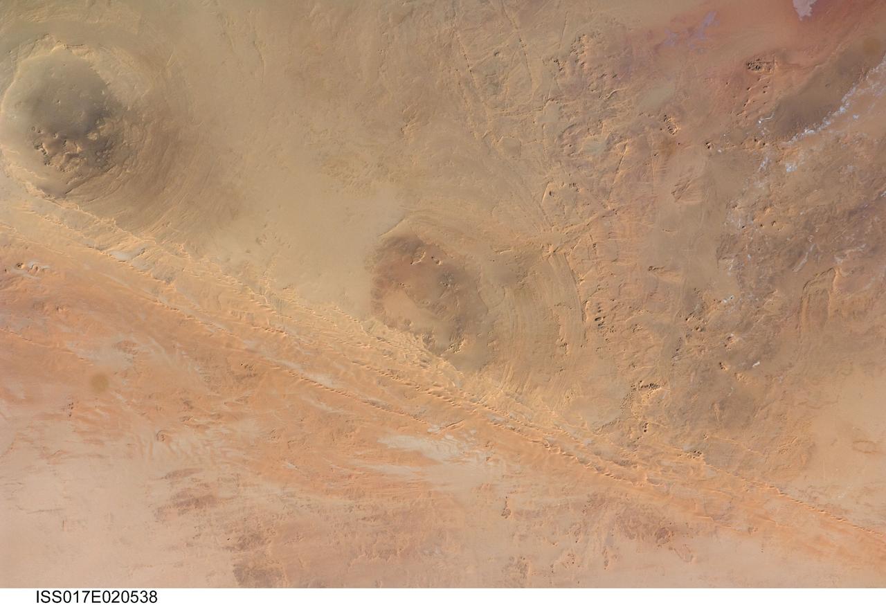
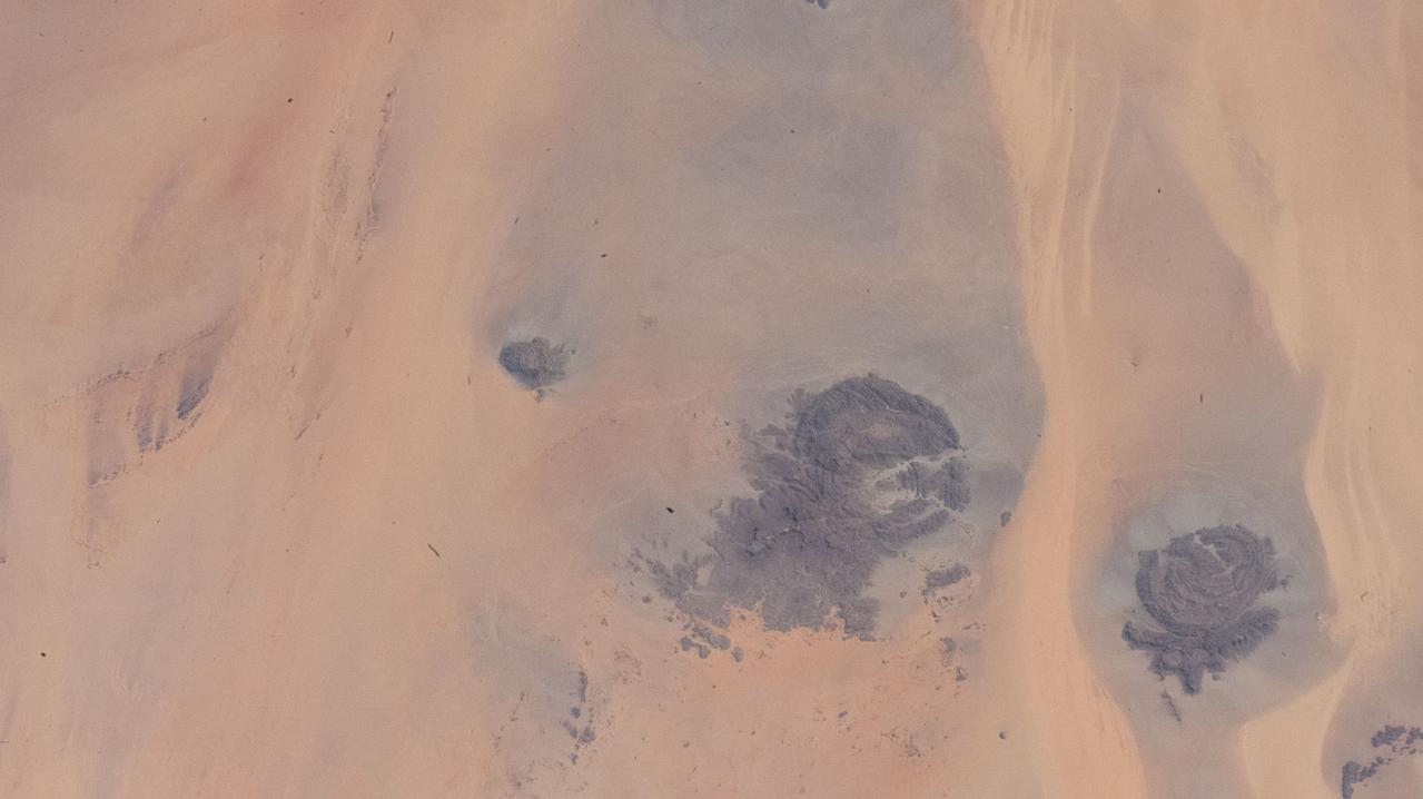
ISS017-E-020538 (21 Oct. 2008) --- Arkenu Craters 1 and 2 in Libya are featured in this image photographed by an Expedition 17 crewmember on the International Space Station. Geologists often study features on Earth, such as impact craters, to gain insight into processes that occur on other planets. On Earth, more than 150 impact craters have been identified on the continents, but only a few of these are classified as double impact craters. One such example, the Arkenu Craters in northern Africa, is shown in this image. Arkenu 1 and 2 are double impact structures located in eastern Libya (22.04 degrees north latitude and 23.45 degrees east longitude) in the Sahara desert, with diameters of approximately 6.8 kilometers and 10.3 kilometers, respectively. The craters are unusual in that they both exhibit concentric annular ridge structures (gray circles in the image indicate the position of the outermost visible ridges). In many terrestrial complex craters these features are highly eroded and no longer visible. While the circular structure of these features had been noted, the impact origin hypothesis was strengthened in December 2003 when a field team observed shatter cones -- conical-shaped features in rocks created by the high shock pressures generated during impact. Large outcrops of impact breccias -- a jumble of rock fragments generated at the impact site that are now cemented together into an identifiable rock layer -- were also observed by the field team. Two impactors, each approximately 500 meters in diameter, are thought to have created the craters. According to scientists, the age of the impact event has been dated as occurring less than 140 million years ago. While the presence of shatter cones and impact breccias is generally considered to be strong evidence for meteor impact, some scientists now question the interpretation of these features observed at the Arkenu structures and suggest that they were caused by erosive and volcanic processes. At present, both craters are being crossed by linear dunes extending northeast-southwest -- the superposition of the dunes across the annular ridges indicates that they are much younger than the craters.
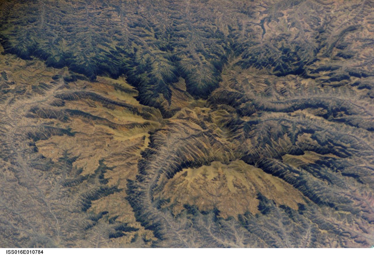
ISS016-E-010784 (16 Nov. 2007) --- Semien Mountains, Gonder, northern Ethiopia are featured in this image photographed by an Expedition 16 crewmember on the International Space Station. The Semien Mountains, the highest parts of the Ethiopian Plateau (above 2,000 meters--6,560 feet), are surrounded by a steep, ragged escarpment (step) with dramatic vertical cliffs, pinnacles, and rock spires - scenery that draws international tourists. Included in the range is the highest point in Ethiopia, Ras Dashen at 4,533 meters (14,926 feet) - an altitude only recently computed with any accuracy. The plateau and surrounding areas are made up of numerous flood basalts, totaling probably more than 3,000 meters in thickness. According to scientists, the lavas erupted quickly (in about one million years) 31 million years ago, as Ethiopia passed above what is known as the Afar "hotspot." The hotspot caused the general region of Ethiopia to be elevated, which encouraged extensive river erosion. This erosion has cut the highly dramatic canyons that ring the plateau. Although the plateau lies in the latitude of the Sahara--Arabia deserts, its great altitude makes for a cool, wet climate. This is shown by light green vegetation, compared with the brown canyons which are hot and dry. The green tinge on the biggest escarpment (trending across the top third of the image) is also vegetation, showing that this part of the escarpment also receives more rain than other parts of the escarpment wall. The Semien Mountains are one of the few places in Africa to regularly receive snow, and they receive plentiful rainfall (more than 1,280 millimeters--55 inches). A major canyon cuts the flatter plateau surface (center), with several more surrounding the plateau. These canyons are hot because they reach low altitudes, more than 2,000 meters below the plateau surface. The Semien Mountains National Park has been declared a World Heritage Site by UNESCO for its rugged beauty. In addition, several extremely rare species are found here, such as the Gelada baboon with its thick coat to protect against the cold; the critically-endangered Walia ibex with long, heavy scimitar-like horns; and the Ethiopian wolf--also known as the Semien jackal, the "most endangered canid."

Africa is front and center in this image of Earth taken by a NASA camera on the Deep Space Climate Observatory (DSCOVR) satellite. The image, taken July 6 from a vantage point one million miles from Earth, was one of the first taken by NASA’s Earth Polychromatic Imaging Camera (EPIC). Central Europe is toward the top of the image with the Sahara Desert to the south, showing the Nile River flowing to the Mediterranean Sea through Egypt. The photographic-quality color image was generated by combining three separate images of the entire Earth taken a few minutes apart. The camera takes a series of 10 images using different narrowband filters -- from ultraviolet to near infrared -- to produce a variety of science products. The red, green and blue channel images are used in these Earth images. The DSCOVR mission is a partnership between NASA, the National Oceanic and Atmospheric Administration (NOAA) and the U.S. Air Force, with the primary objective to maintain the nation’s real-time solar wind monitoring capabilities, which are critical to the accuracy and lead time of space weather alerts and forecasts from NOAA. DSCOVR was launched in February to its planned orbit at the first Lagrange point or L1, about one million miles from Earth toward the sun. It’s from that unique vantage point that the EPIC instrument is acquiring images of the entire sunlit face of Earth. Data from EPIC will be used to measure ozone and aerosol levels in Earth’s atmosphere, cloud height, vegetation properties and a variety of other features. Image Credit: NASA
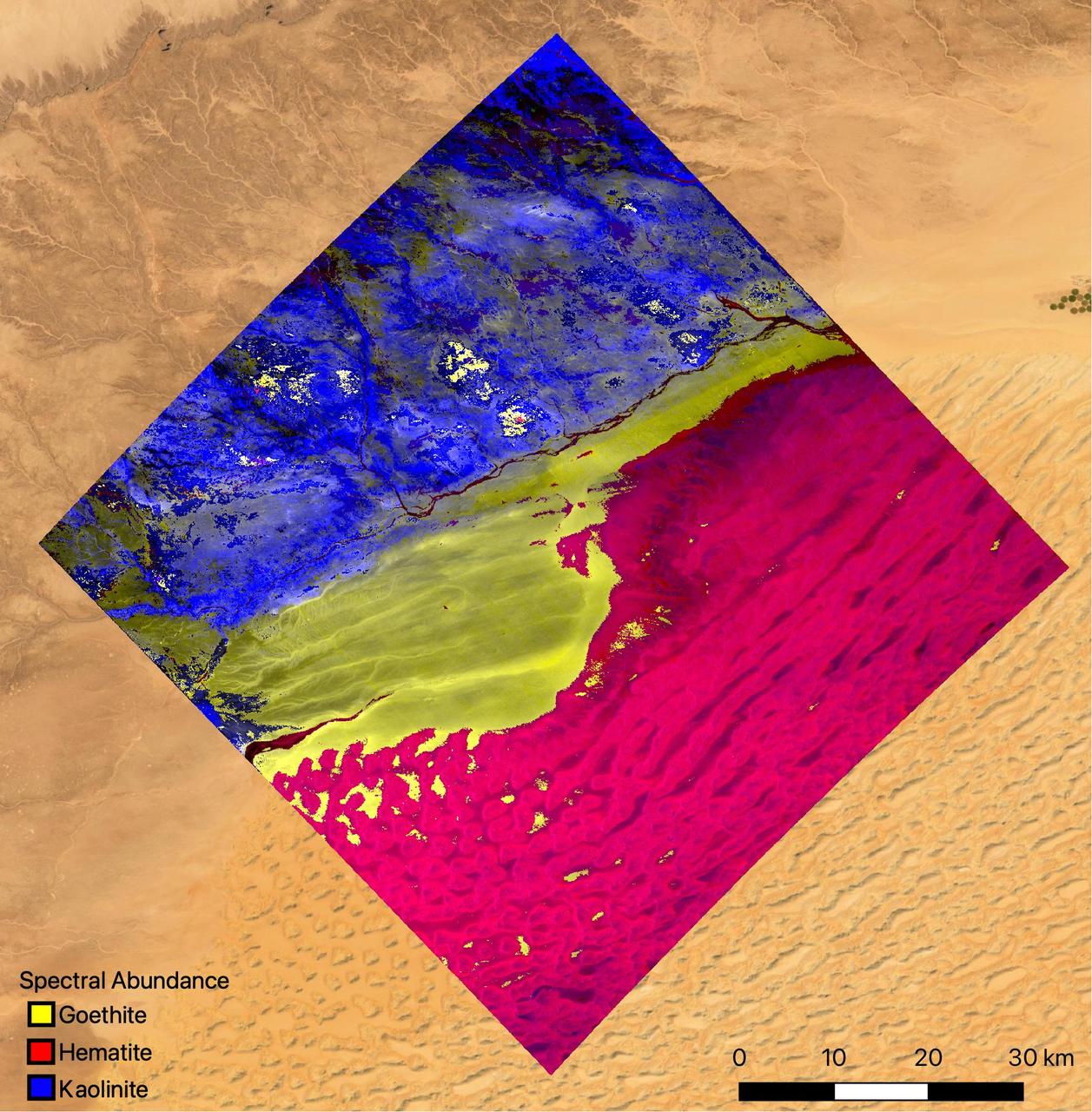
The mineral map shows an area of southwestern Libya in the Sahara Desert observed by NASA's Earth Surface Mineral Dust Source Investigation (EMIT) mission as it maps the world's mineral dust sources, gathering information about surface composition as the instrument, designed at NASA's Jet Propulsion Laboratory in Southern California, orbits aboard the International Space Station. The instrument works by measuring reflected solar energy from Earth across hundreds of wavelengths from the visible to the infrared range of the spectrum. The intensity of the reflected light varies by wavelength based on the material. Scientists are using these patterns, called spectral fingerprints, to identify surface minerals and pinpoint their locations on a map. The map is among the first produced by scientists with EMIT data. Analysis of the patterns indicate that the surface contains kaolinite, a light-colored clay mineral, and goethite and hematite, two varieties of iron oxide, which is darker. When dust from the kaolinite-dominated areas is lofted into the atmosphere, the particles tend to scatter sunlight and reflect it back to space, cooling the air. The opposite effect occurs with airborne particles of iron oxide, which tend to absorb heat and warm the surrounding air. Over the course of its 12-month mission, EMIT will collect measurements of 10 important surface minerals – kaolinite, hematite, goethite, illite, vermiculite, calcite, dolomite, montmorillonite, chlorite, and gypsum – in arid regions between 50-degree south and north latitudes in Africa, Asia, North and South America, and Australia. The data EMIT collects will help scientists better understand the role of airborne dust particles in heating and cooling Earth's atmosphere on global and regional scales. EMIT was developed at NASA's Jet Propulsion Laboratory, which is managed for the agency by Caltech in Pasadena, California. It launched to the space station in July 2022. https://photojournal.jpl.nasa.gov/catalog/PIA25424
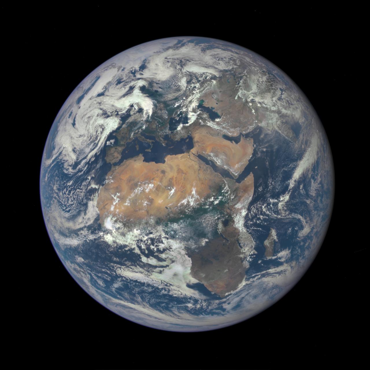
Africa is front and center in this image of Earth taken by a NASA camera on the Deep Space Climate Observatory (DSCOVR) satellite. The image, taken July 6 from a vantage point one million miles from Earth, was one of the first taken by NASA’s Earth Polychromatic Imaging Camera (EPIC). Central Europe is toward the top of the image with the Sahara Desert to the south, showing the Nile River flowing to the Mediterranean Sea through Egypt. The photographic-quality color image was generated by combining three separate images of the entire Earth taken a few minutes apart. The camera takes a series of 10 images using different narrowband filters -- from ultraviolet to near infrared -- to produce a variety of science products. The red, green and blue channel images are used in these Earth images. The DSCOVR mission is a partnership between NASA, the National Oceanic and Atmospheric Administration (NOAA) and the U.S. Air Force, with the primary objective to maintain the nation’s real-time solar wind monitoring capabilities, which are critical to the accuracy and lead time of space weather alerts and forecasts from NOAA. DSCOVR was launched in February to its planned orbit at the first Lagrange point or L1, about one million miles from Earth toward the sun. It’s from that unique vantage point that the EPIC instrument is acquiring images of the entire sunlit face of Earth. Data from EPIC will be used to measure ozone and aerosol levels in Earth’s atmosphere, cloud height, vegetation properties and a variety of other features. Image Credit: NASA <b><a href="http://www.nasa.gov/audience/formedia/features/MP_Photo_Guidelines.html" rel="nofollow">NASA image use policy.</a></b> <b><a href="http://www.nasa.gov/centers/goddard/home/index.html" rel="nofollow">NASA Goddard Space Flight Center</a></b> enables NASA’s mission through four scientific endeavors: Earth Science, Heliophysics, Solar System Exploration, and Astrophysics. Goddard plays a leading role in NASA’s accomplishments by contributing compelling scientific knowledge to advance the Agency’s mission. <b>Follow us on <a href="http://twitter.com/NASAGoddardPix" rel="nofollow">Twitter</a></b> <b>Like us on <a href="http://www.facebook.com/pages/Greenbelt-MD/NASA-Goddard/395013845897?ref=tsd" rel="nofollow">Facebook</a></b> <b>Find us on <a href="http://instagrid.me/nasagoddard/?vm=grid" rel="nofollow">Instagram</a></b>

NASA's Lunar Reconnaissance Orbiter (LRO) recently captured a unique view of Earth from the spacecraft's vantage point in orbit around the moon. "The image is simply stunning," said Noah Petro, Deputy Project Scientist for LRO at NASA's Goddard Space Flight Center in Greenbelt, Maryland. "The image of the Earth evokes the famous 'Blue Marble' image taken by Astronaut Harrison Schmitt during Apollo 17, 43 years ago, which also showed Africa prominently in the picture." In this composite image we see Earth appear to rise over the lunar horizon from the viewpoint of the spacecraft, with the center of the Earth just off the coast of Liberia (at 4.04 degrees North, 12.44 degrees West). The large tan area in the upper right is the Sahara Desert, and just beyond is Saudi Arabia. The Atlantic and Pacific coasts of South America are visible to the left. On the moon, we get a glimpse of the crater Compton, which is located just beyond the eastern limb of the moon, on the lunar farside. LRO was launched on June 18, 2009, and has collected a treasure trove of data with its seven powerful instruments, making an invaluable contribution to our knowledge about the moon. LRO experiences 12 earthrises every day; however the spacecraft is almost always busy imaging the lunar surface so only rarely does an opportunity arise such that its camera instrument can capture a view of Earth. Occasionally LRO points off into space to acquire observations of the extremely thin lunar atmosphere and perform instrument calibration measurements. During these movements sometimes Earth (and other planets) pass through the camera's field of view and dramatic images such as the one shown here are acquired. This image was composed from a series of images taken Oct. 12, when LRO was about 83 miles (134 kilometers) above the moon's farside crater Compton. Capturing an image of the Earth and moon with LRO's Lunar Reconnaissance Orbiter Camera (LROC) instrument is a complicated task. First the spacecraft must be rolled to the side (in this case 67 degrees), then the spacecraft slews with the direction of travel to maximize the width of the lunar horizon in LROC's Narrow Angle Camera image. All this takes place while LRO is traveling faster than 3,580 miles per hour (over 1,600 meters per second) relative to the lunar surface below the spacecraft! The high-resolution Narrow Angle Camera (NAC) on LRO takes black-and-white images, while the lower resolution Wide Angle Camera (WAC) takes color images, so you might wonder how we got a high-resolution picture of the Earth in color. Since the spacecraft, Earth, and moon are all in motion, we had to do some special processing to create an image that represents the view of the Earth and moon at one particular time. The final Earth image contains both WAC and NAC information. WAC provides the color, and the NAC provides high-resolution detail. "From the Earth, the daily moonrise and moonset are always inspiring moments," said Mark Robinson of Arizona State University in Tempe, principal investigator for LROC. "However, lunar astronauts will see something very different: viewed from the lunar surface, the Earth never rises or sets. Since the moon is tidally locked, Earth is always in the same spot above the horizon, varying only a small amount with the slight wobble of the moon. The Earth may not move across the 'sky', but the view is not static. Future astronauts will see the continents rotate in and out of view and the ever-changing pattern of clouds will always catch one's eye, at least on the nearside. The Earth is never visible from the farside; imagine a sky with no Earth or moon - what will farside explorers think with no Earth overhead?" NASA's first Earthrise image was taken with the Lunar Orbiter 1 spacecraft in 1966. Perhaps NASA's most iconic Earthrise photo was taken by the crew of the Apollo 8 mission as the spacecraft entered lunar orbit on Christmas Eve Dec. 24, 1968. That evening, the astronauts -- Commander Frank Borman, Command Module Pilot Jim Lovell, and Lunar Module Pilot William Anders -- held a live broadcast from lunar orbit, in which they showed pictures of the Earth and moon as seen from their spacecraft. Said Lovell, "The vast loneliness is awe-inspiring and it makes you realize just what you have back there on Earth." Credit: NASA/Goddard/Arizona State University <b><a href="http://www.nasa.gov/audience/formedia/features/MP_Photo_Guidelines.html" rel="nofollow">NASA image use policy.</a></b> <b><a href="http://www.nasa.gov/centers/goddard/home/index.html" rel="nofollow">NASA Goddard Space Flight Center</a></b> enables NASA’s mission through four scientific endeavors: Earth Science, Heliophysics, Solar System Exploration, and Astrophysics. Goddard plays a leading role in NASA’s accomplishments by contributing compelling scientific knowledge to advance the Agency’s mission. <b>Follow us on <a href="http://twitter.com/NASAGoddardPix" rel="nofollow">Twitter</a></b> <b>Like us on <a href="http://www.facebook.com/pages/Greenbelt-MD/NASA-Goddard/395013845897?ref=tsd" rel="nofollow">Facebook</a></b> <b>Find us on <a href="http://instagrid.me/nasagoddard/?vm=grid" rel="nofollow">Instagram</a></b>