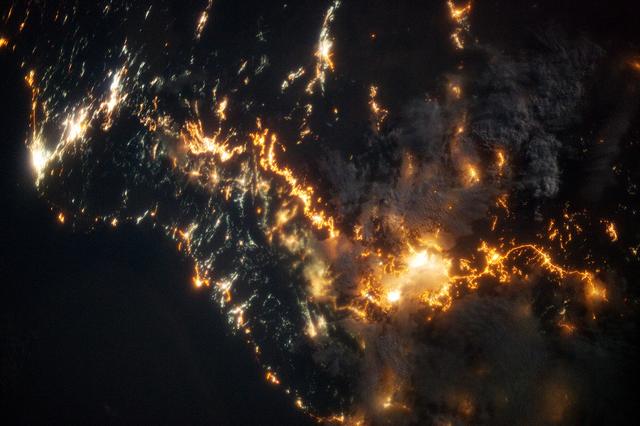
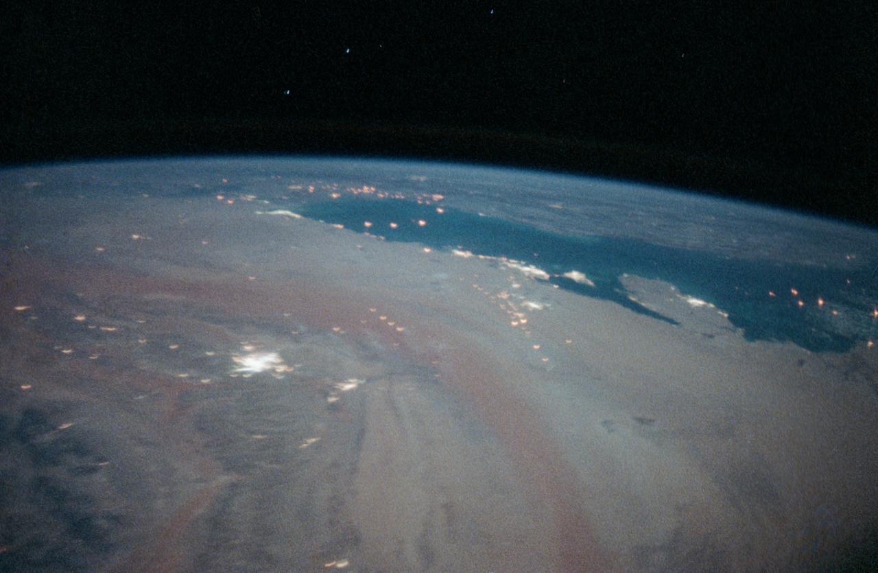
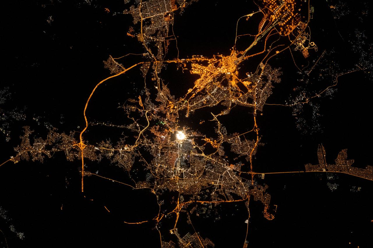
This striking image of the coastline of southwestern Saudi Arabia was taken by astronauts on the International Space Station. Patchy cloud cover partially obscures and blurs the city lights, especially in the vicinity of Khamis Mushait and Abha. While much of the country is lightly populated desert—and relatively dark at night due to lack of city and roadway lights—the southwestern coastal region has a more moderate climate and several large cities. Three brightly lit urban centers are visible at image top left: Jeddah, Mecca, and Taif. Jeddah is the gateway city for Islamic pilgrims going to nearby Mecca, a religious journey known as the Hajj. Taif is located on the slopes of the Sarawat Mountains and provides a summer retreat for the Saudi government from the desert heat of the capital, Riyadh. Bright yellow-orange lighting marks highways that parallel the trend of the Asir Mountains (image center), connecting Mecca to the resort cities of Al Bahah and Abha. Smaller roadways, lit with blue lights, extend to the west to small cities along the Red Sea coastline. The bright yellow-orange glow of the city of Abha is matched by that of Khamis Mushait (or Khamis Mushayt) to the northeast. The brightly lit ribbon of highway continues towards other large cities to the south (Jazan, not shown) and southeast (Najran, not shown). Astronaut photograph ISS036-E-25802 was acquired on July 26, 2013, with a Nikon D3S digital camera using a 50 millimeter lens, and is provided by the ISS Crew Earth Observations experiment and Image Science & Analysis Laboratory, Johnson Space Center. The image was taken by the Expedition 36 crew. It has been cropped and enhanced to improve contrast, and lens artifacts have been removed. The International Space Station Program supports the laboratory as part of the ISS National Lab to help astronauts take pictures of Earth that will be of the greatest value to scientists and the public, and to make those images freely available on the Internet. Additional images taken by astronauts and cosmonauts can be viewed at the NASA/JSC Gateway to Astronaut Photography of Earth. Caption by William L. Stefanov, Jacobs/JETS at NASA-JSC. Instrument: ISS - Digital Camera More info: <a href="http://1.usa.gov/13TqPcr" rel="nofollow">1.usa.gov/13TqPcr</a> Credit: <b><a href="http://www.earthobservatory.nasa.gov/" rel="nofollow"> NASA Earth Observatory</a></b> <b><a href="http://www.nasa.gov/audience/formedia/features/MP_Photo_Guidelines.html" rel="nofollow">NASA image use policy.</a></b> <b><a href="http://www.nasa.gov/centers/goddard/home/index.html" rel="nofollow">NASA Goddard Space Flight Center</a></b> enables NASA’s mission through four scientific endeavors: Earth Science, Heliophysics, Solar System Exploration, and Astrophysics. Goddard plays a leading role in NASA’s accomplishments by contributing compelling scientific knowledge to advance the Agency’s mission. <b>Follow us on <a href="http://twitter.com/NASA_GoddardPix" rel="nofollow">Twitter</a></b> <b>Like us on <a href="http://www.facebook.com/pages/Greenbelt-MD/NASA-Goddard/395013845897?ref=tsd" rel="nofollow">Facebook</a></b> <b>Find us on <a href="http://instagram.com/nasagoddard?vm=grid" rel="nofollow">Instagram</a></b>
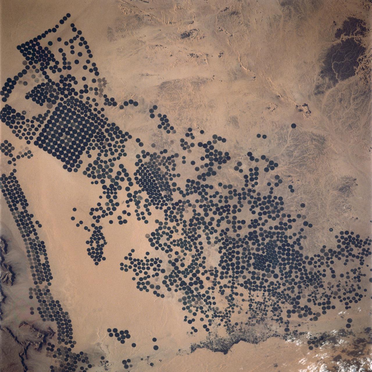
STS062-151-220 (4-18 March 1994) --- Great numbers of circular, center-pivot irrigation plots appear in this west-looking view of the northern Saudi Arabia (center to lower left). So many plots now exist that the face of Saudi Arabia as seen from low earth orbit has changed. Until a few years ago, there were only a few scattered center-pivots. Now the entire swath of country between the shifting sands of the Ad Dahna Sand Sea (light colors center and right) and the almost soilless Nejd Plateau (left) has been darkened by thousands of these agricultural fields. The Nejd Plateau is a mass of dark rocks, some volcanic, in NW Saudi Arabia. Water from this higher country flows east towards the agricultural region where it is pumped up from underground aquifers. The weep of the Ad Dahna Sand Sea is one of the major features of Saudi Arabia (center and right) as seen from the orbiter. The dunes follow the trend of regional winds (northwesterly in the center of the view) which circulate around the Nejd plateau. The north end of the Red Sea can be seen top left with the Sinai Peninsula and Mediterranean are just visible center top. Iraq is under cloud top right.
The Wajid Aquifer in Saudi Arabia underlies about 450,000 square kilometers in Saudi Arabia and Yemen. The area around Wadi Al Dawasir, Saudi Arabia, relies on the aquifer to provide water for the extensive development of agriculture. As a result the water level in the aquifer system has dropped 6m/yr for the past 20 to 30 years. Heavy use of water has led to the exhaustion of the aquifer in some areas (Inventory of Shared Water Resources in Western Asia. DOI: https://dx.doi.org/10.18356/d8517580-en). The images were acquired June 30, 2000, and April 26, 2017, cover an area of 34.6 by 43.9 kilometers, and are located at 20.1 degrees north, 44.7 degrees east. https://photojournal.jpl.nasa.gov/catalog/PIA23490
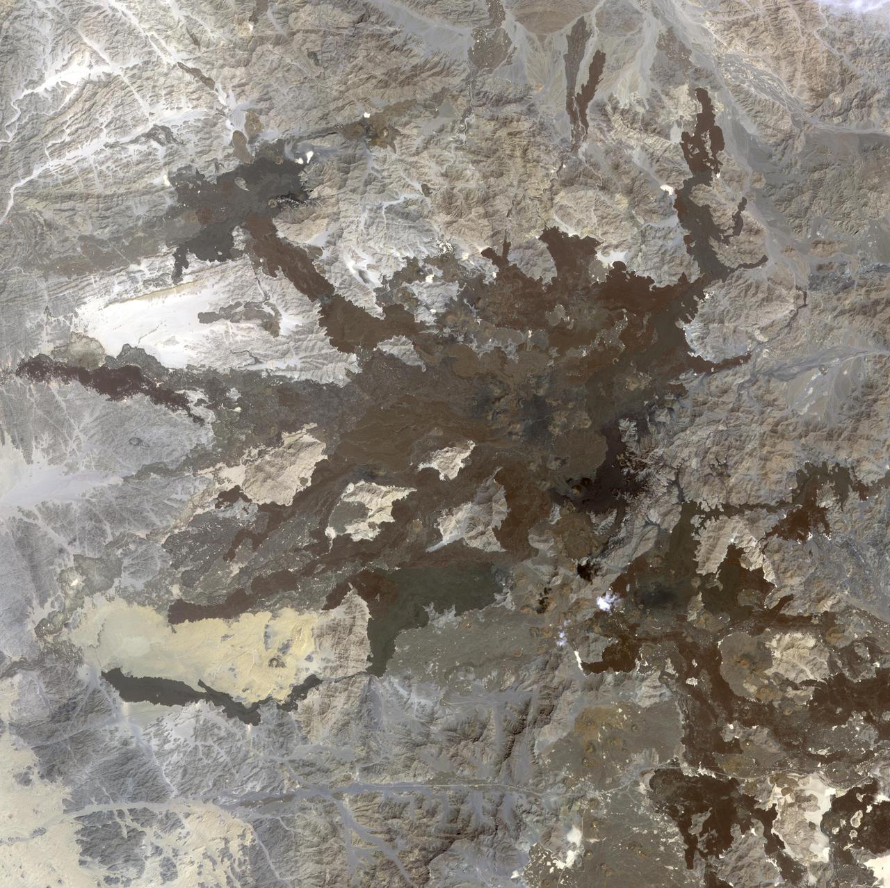
This image from NASA Terra spacecraft shows a northwest area of Saudi Arabia, Harrat Lunayyir, that reveals that the area is unexpectedly volcanically active.
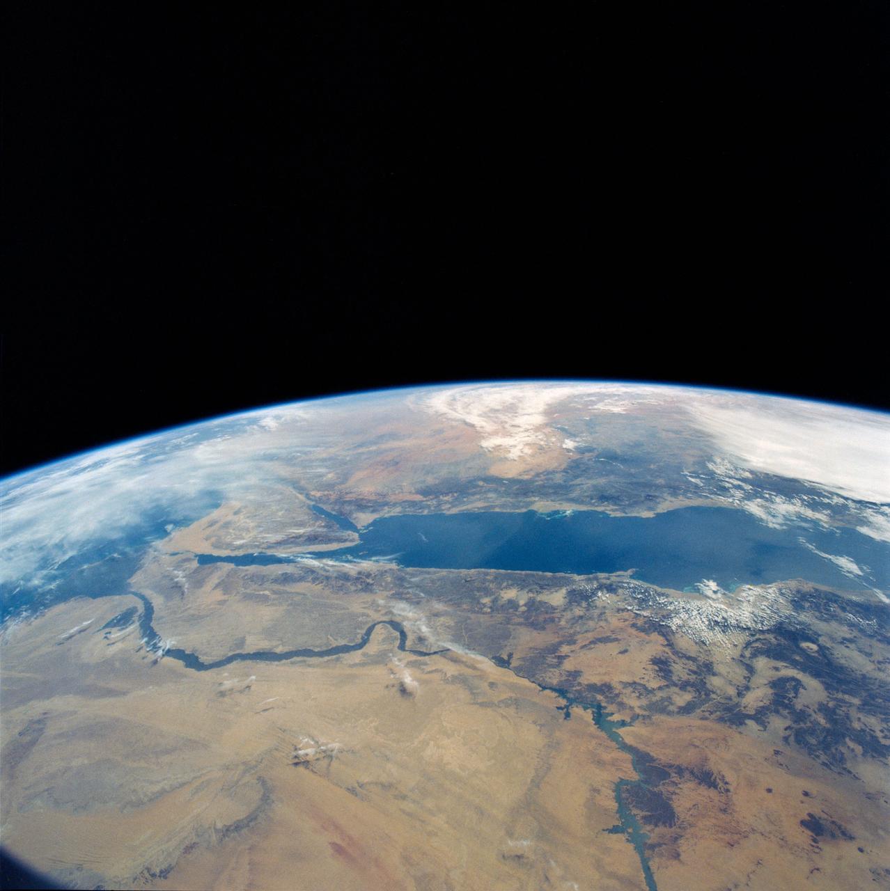
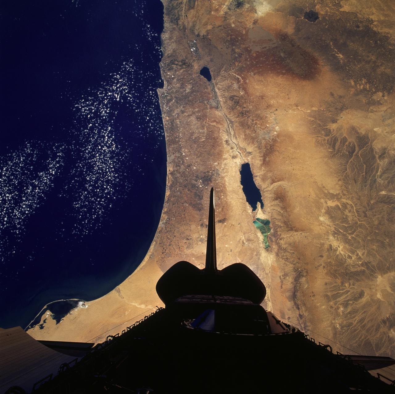
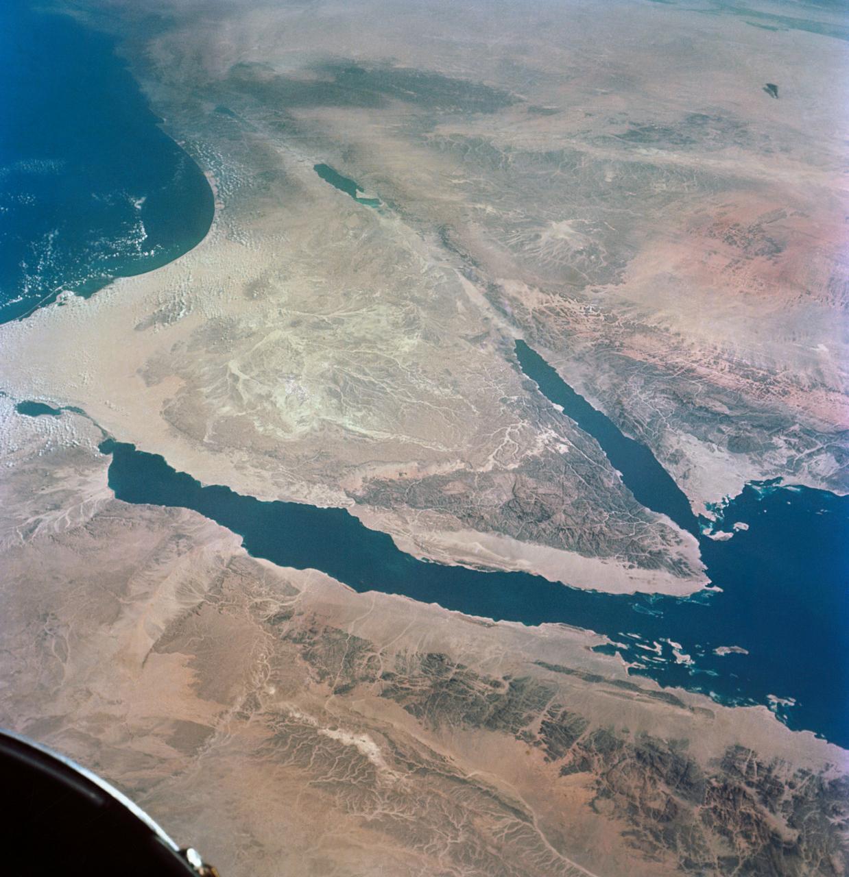
STS031-79-015 (24-29 April 1990) --- The 330-plus nautical mile orbital altitude of the Space Shuttle Discovery allowed for this unique high oblique 70mm Hasselblad frame. Egypt is in the foreground, with the Nile River and Lake Nasser readily identifiable. Cairo and Alexandria are visible. The Mediterranean Sea is on the horizon in upper left. The Red Sea is in the center. Other areas seen include Saudi Arabia, Jordan, Palestine and Israel; the Gulf of Aqaba and the Gulf of Suez.
Acquired by NASA Terra spacecraft on in 2011, this image shows the Wadi As-Sirhan Basin in northwest Saudi Arabia, which has been steadily developing agricultural fields using center pivot irrigation by tapping into fossil ground water.
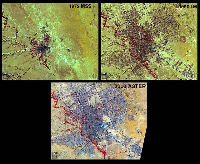
Riyadh, the national capital of Saudi Arabia, is shown in 1972, 1990 and 2000. Its population grew in these years from about a half million to more than two million. Saudi Arabia experienced urbanization later than many other countries; in the early 1970s its urban-rural ratio was still about 1:3. By 1990 that had reversed to about 3:1. The city grew through in-migration from rural areas, and from decreases in the death rate while birthrates remained high. The 1972 image is a Landsat MSS scene; the 1990 image is a Landsat Thematic Mapper scene; and the 2000 image is an ASTER scene. All three images cover an area of about 27 x 34 km. The image is centered at 24.6 degrees north latitude, 46.6 degrees east longitude. http://photojournal.jpl.nasa.gov/catalog/PIA11087
AS07-07-1774 (15 Oct. 1968) --- Red Sea coastal area of Saudi Arabia as seen from the Apollo 7 spacecraft during its 58th revolution of Earth. This picture shows extent of coral reefs in the Red Sea. Photographed from an altitude of 88 nautical miles, at ground elapsed time of 91 hours and 17 minutes.
This image from NASA EarthKAM shows pivot irrigation near the city of As Sulayyil Sulayel, Saudi Arabia. The edge of the Rub al-Khali or Empty Quarter is visible in the southeast.
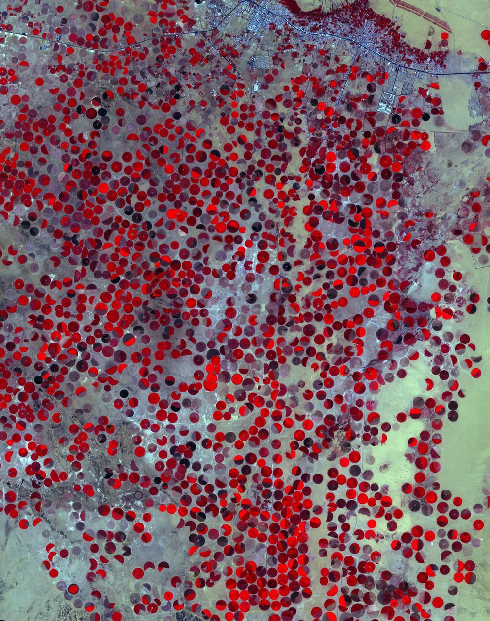
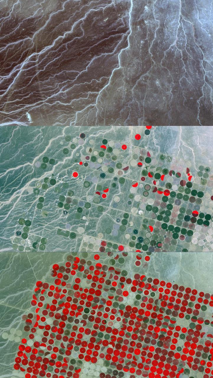
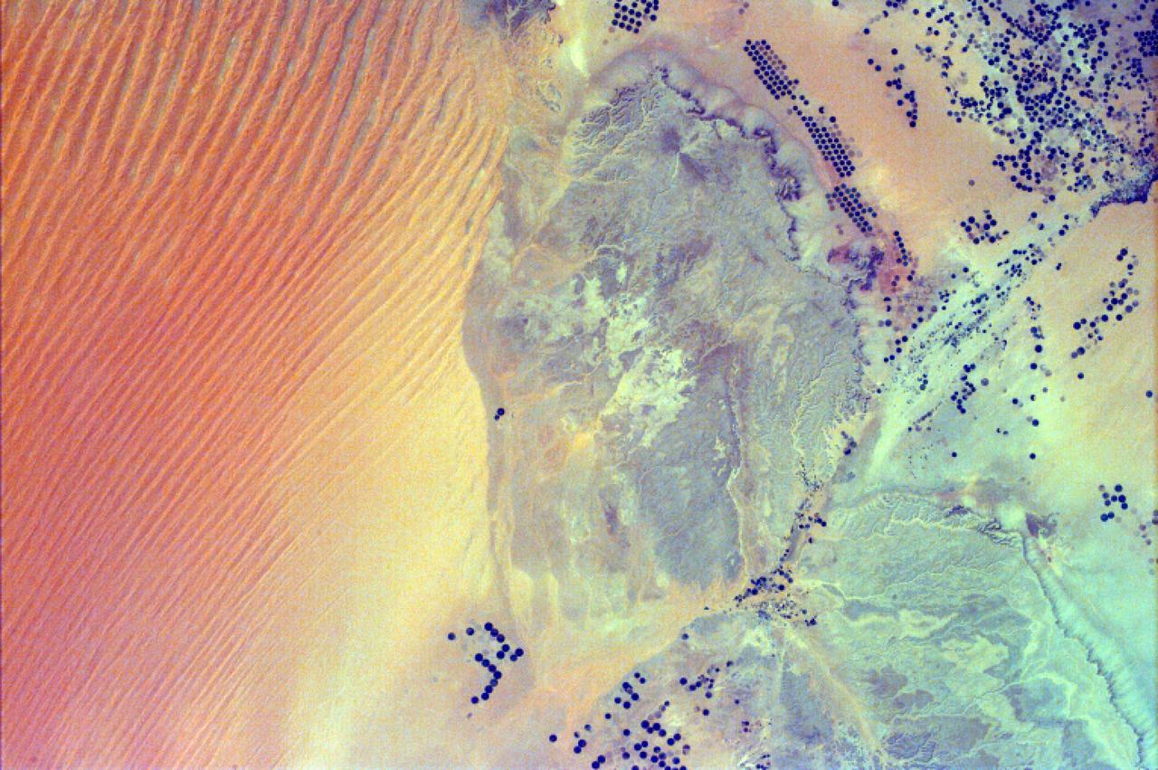
In Saudi Arabia, center-pivot, swing-arm irrigated agriculture complexes such as the one imaged at Jabal Tuwayq (20.5N, 45.0 E) extract deep fossil water reserves to achieve food crop production self sufficiency in this desert environment. The significance of the Saudi expanded irrigated agriculture is that the depletion of this finite water resource is a short term solution to a long term need that will still exist when the water has been extracted.
In the Al Jowf Province in northwestern Saudi Arabia, mining of fossil ground water has created an enormous agricultural enterprise, where tens of thousands of date palms and olive trees thrive in a hyper-arid environment. In a short 30-year period, the area has grown from 22 center-pivot irrigated fields to thousands. The Landsat TM image (Figure 1) was acquired March 30, 1989; the ASTER image on February 17, 2020. The images cover an area of 33.2 by 49 km, and are located at 30.1 degrees north, 38.3 degrees east. https://photojournal.jpl.nasa.gov/catalog/PIA23955
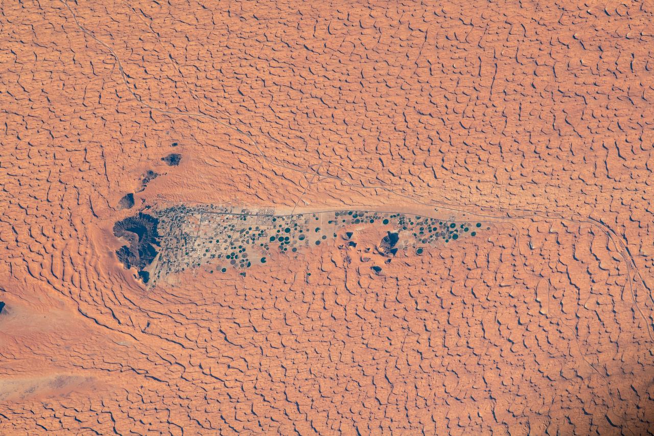
In the middle of the Arabian desert the city Green Oasis Wadi Al Dawasir is being developed as a new urban center for the Wadi Al Dawasir region of Saudi Arabia, as shown in this image from NASA Terra spacecraft. Huge solar fields supply the entire city and the surrounding region with energy. Hundreds of circular agricultural fields are fed by center pivot irrigation apparatus, drawing water from subterranean aquifers. The image was acquired March 30, 2013, covers an area of 30 x 45 km, and is located at 20.2 degrees north, 44.8 degrees east. http://photojournal.jpl.nasa.gov/catalog/PIA20077
iss072e519565 (Jan. 22, 2025) --- Riyadh, Saudi Arabia, the desert nation's capital and largest city with a population af about 7 million, are pictured at aproximately 10:38 p.m. local time from the International Space Station as it orbited 258 miles above.
iss072e445326 (Dec. 28, 2024) --- Riyadh, Saudi Arabia's capital and the largest city on the Arabian peninsula with a population of about 7 million residents, is pictured at approximately 11:30 p.m. local time from the International Space Station as it orbited 257 miles above.
iss069e010867 (May 16, 2023) --- Sand dunes in the desert area along the Saudi Arabia-Oman border were pictured by UAE (United Arab Emirates) astronaut and Expedition 69 Flight Engineer Sultan Alneyadi from the International Space Station as it orbited 256 miles above.
iss069e010869 (May 16, 2023) --- Sand dunes in the desert area along the Saudi Arabia-Oman border were pictured by UAE (United Arab Emirates) astronaut and Expedition 69 Flight Engineer Sultan Alneyadi from the International Space Station as it orbited 256 miles above.
iss073e0134562 (May 22, 2025) --- The port city of Dammam, Saudi Arabia, with a population of about 1.38 million on the Persian Gulf coast, is pictured at approximately 10:43 p.m. local time from the International Space Station as it orbited 259 miles above the Middle East.
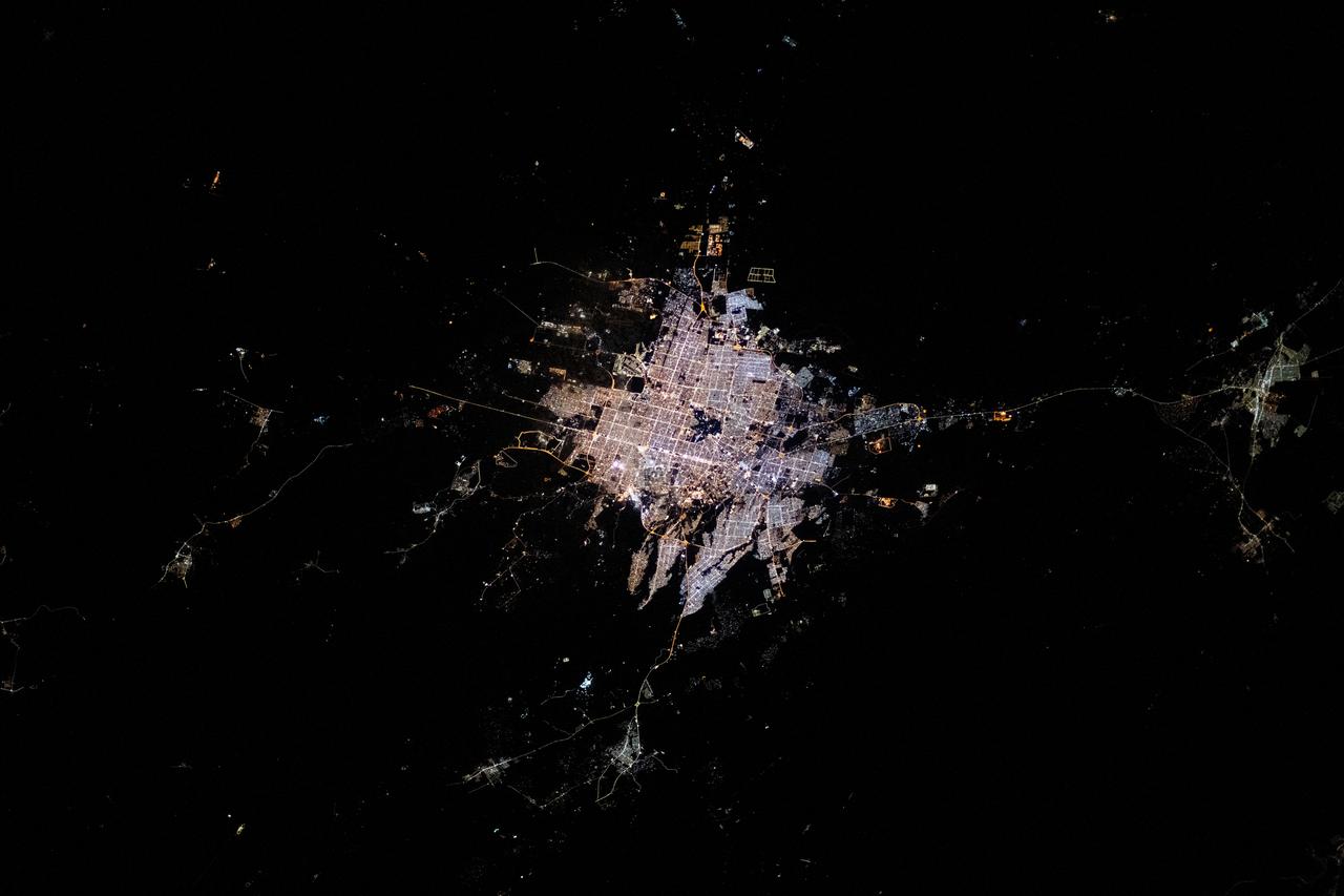
iss073e0222623 (May 25, 2025) --- Riyadh, Saudi Arabia, the Middle Eastern nation's capital and largest city with a population of about 7 million located in the Nafud desert, is pictured at approximately 9:56 p.m. local time from the International Space Station as it orbited 259 miles above the Arabian Peninsula.
A high oblique view of the Middle East centered at approximately 28.0 degrees north and 34.0 degrees east. Portions of the countries of Egypt, Israel, Jordan and Saudi Arabia are visible. The Dead Sea Rift Valley continuing into the Gulf of Aqaba marks the boundary between Israel and Jordan. The vegetation change in the Sinai Peninsula is the border between the Gaza Strip and Egypt. In Egypt, the Suez Canal connects the Gulf of Suez with the Mediterranean Sea and forms the western boundary of the Sinai Peninsula. The green ribbon of the Nile River is in marked contrast to this arid region. Even the Jordan River does not support large scale agriculture.
STS-35 Earth observation taken aboard Columbia, Orbiter Vehicle (OV) 102, is of the Persian Gulf area. Major cities and oilfields of the countries of Saudi Arabia (foreground), Iraq (top left), Iran (top center and top right), Kuwait, Bahrain, Qatar, and a portion of the United Arab Emirates are visible in this scene. The cities are the large whitish areas of city lights. Flares characteristic of the Mid-East oil field practices are visible both onshore and offshore throughout the scene. Major cities identifiable are in Iraq - Baghdad, Basra, and Faw; in Qatar - Ab Dawhah; in Kuwait - Kuwait City; in Saudi Arabia - Riyadh, Al Jubayl, Dharan, Al Huf, Ad Dilam and Al Hariq; and Bahrain and its associated causeway to the mainland.
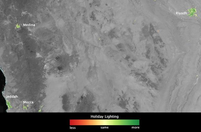
In several cities in the Middle East, city lights brighten during the Muslim holy month of Ramadan, as seen using a new analysis of daily data from the NASA-NOAA Suomi NPP satellite. Dark green pixels are areas where the lights are 50 percent brighter, or more, during Ramadan. Credit: Jesse Allen, NASA’s Earth Observatory Read more: <a href="http://www.nasa.gov/content/goddard/satellite-sees-holiday-lights-brighten-cities" rel="nofollow">www.nasa.gov/content/goddard/satellite-sees-holiday-light...</a> <b><a href="http://www.nasa.gov/audience/formedia/features/MP_Photo_Guidelines.html" rel="nofollow">NASA image use policy.</a></b> <b><a href="http://www.nasa.gov/centers/goddard/home/index.html" rel="nofollow">NASA Goddard Space Flight Center</a></b> enables NASA’s mission through four scientific endeavors: Earth Science, Heliophysics, Solar System Exploration, and Astrophysics. Goddard plays a leading role in NASA’s accomplishments by contributing compelling scientific knowledge to advance the Agency’s mission. <b>Follow us on <a href="http://twitter.com/NASAGoddardPix" rel="nofollow">Twitter</a></b> <b>Like us on <a href="http://www.facebook.com/pages/Greenbelt-MD/NASA-Goddard/395013845897?ref=tsd" rel="nofollow">Facebook</a></b> <b>Find us on <a href="http://instagram.com/nasagoddard?vm=grid" rel="nofollow">Instagram</a></b>
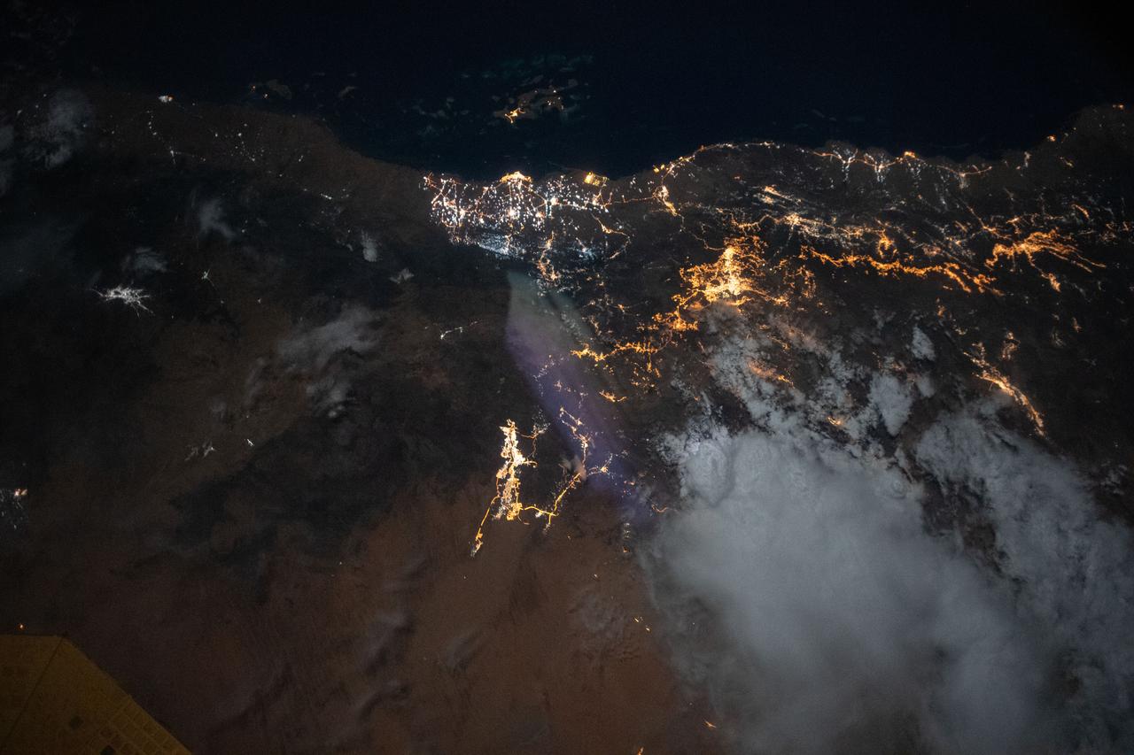
iss072e445148 (Dec. 28, 2024) --- City lights illuminate this triangular area comprising the cities of Abha, Khamis Mushait, and Ahad Rafidah, with a total metropolitan population of about 2.5 million residents in southwestern Saudi Arabia. The International Space Station was orbiting 256 miles above the Arabian Peninsula at approximately 11:28 p.m. local time.
Clear skies on April 11, 2004 top panels contrast strongly with the dust storm that swept across Iraq and Saudi Arabia on May 13 bottom panels as seen by NASA Terra spacecraft.
iss069e004755 (April 20, 2023) --- Riyadh, Saudi Arabia's capital and largest city, was pictured by NASA astronaut and Expedition 69 Flight Engineer Woody Hoburg as the International Space Station orbited 258 miles above.
iss062e112826 (March 25, 2020) --- Dammam, the capital city of the Eastern Province of Saudi Arabia, is pictured frm the International Space Station orbited above the Arabia Peninsula.
AS17-148-22718 (7-19 Dec. 1972) --- This excellent view of Saudi Arabia and the north eastern portion of the African continent was photographed by the Apollo 17 astronauts with a hand-held camera on their trans-lunar coast toward man's last lunar visit. Egypt, Sudan, Ethiopia are some of the African nations are visible. Iran, Iraq, Jordan are not so clearly visible because of cloud cover and their particular location in the picture. India is dimly visible at right of frame. The Red Sea is seen entirely in this one single frame, a rare occurrence in Apollo photography or any photography taken from manned spacecraft. The Gulf of Suez, the Dead Sea, Gulf of Aden, Persian Gulf and Gulf of Oman are also visible. This frame is one of 169 frames on film magazine NN carried aboard Apollo 17, all of which are SO368 (color) film. A 250mm lens on a 70mm Hasselblad camera recorded the image, one of 92 taken during the trans-lunar coast. Note AS17-148-22727 (also magazine NN) for an excellent full Earth picture showing the entire African continent.
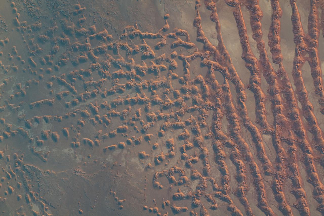
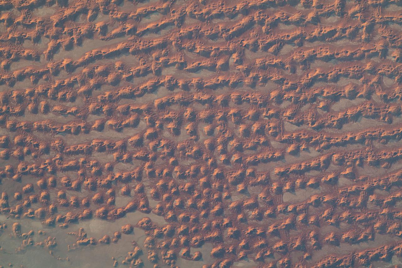
This image of Saudi Arabia shows a great sea of linear dunes in part of the Rub' al Khali, or the Empty Quarter. Acquired on June 25, 2000, the image covers an area 37 kilometers (23 miles) wide and 28 kilometers (17 miles) long in three bands of the reflected visible and infrared wavelength region. The dunes are yellow due to the presence of iron oxide minerals. The inter-dune area is made up of clays and silt and appears blue due to its high reflectance in band 1. The Rub' al Khali is the world's largest continuous sand desert. It covers about 650,000 square kilometers (250,966 square miles) and lies mainly in southern Saudi Arabia, though it does extend into the United Arab Emirates, Oman, and Yemen. One of the world's driest areas, it is uninhabited except for the Bedouin nomads who cross it. The first European to travel through the desert was Bertram Thomas in 1930. http://photojournal.jpl.nasa.gov/catalog/PIA02656

View of the audience at the memorial service at JSC for the Crew of STS 51-L. Sultan Salman Abdelazize Al-Saud of Saudi Arabia is seen in the center of the view.
iss063e006714 (May 5, 2020) --- The well lit Persian Gulf coast of Saudi Arabia is pictured from the International Space Station during an orbital night pass.
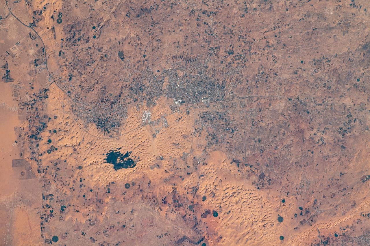
iss064e006313 (Nov. 26, 2020) --- The oasis city of Sakakah in northwestern Saudi Arabia is pictured from the International Space Station as it orbited 261 miles above.
iss069e033385 (July 19, 2023) -- As the International Space Station orbited roughly 260 miles above Saudi Arabia, United Arab Emirates (UAE) Flight Engineer Sultan Alneyadi snapped this photograph.
iss068e024291 (Nov. 24, 2022) --- Qatar, the island Kingdom of Bahrain, and the eastern coast of Saudi Arabia on the Persian Gulf are pictured from the International Space Station as it orbited 258 miles above the Arabian Peninsula.
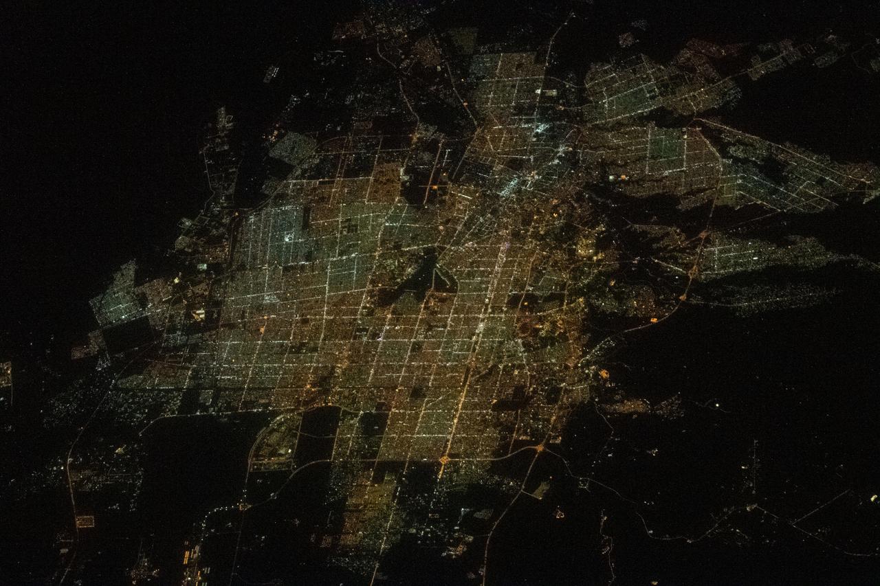
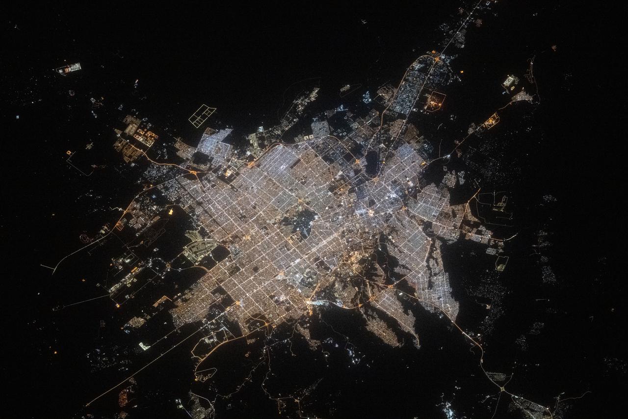
iss064e021949 (Jan. 9, 2021) --- Riyadh, the desert city and capital of Saudi Arabia, with a population of 7.6 million, is pictured from the International Space Station as it orbited 261 miles above the Arabian Peninsula.
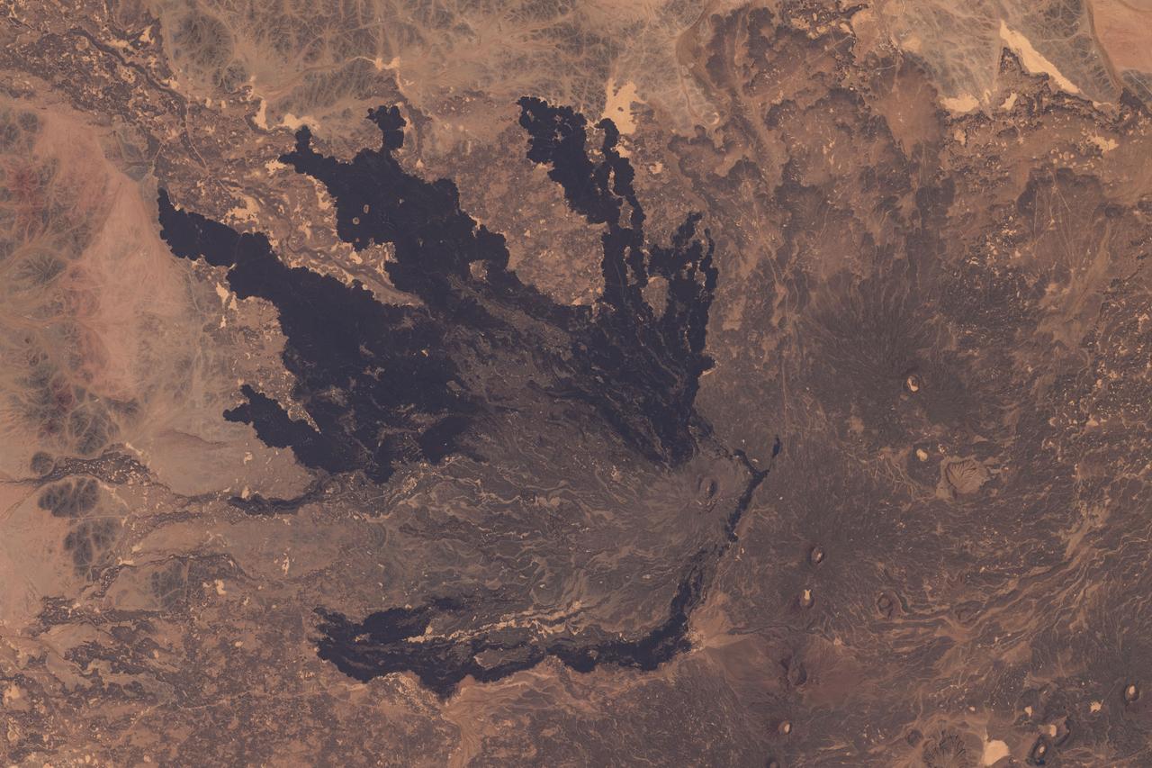
iss071e235550 (June 26, 2024) --- A lava field southeast of Medina, Saudi Arabia, is pictured from the International Space Station as it orbited 263 miles above the Arabian Peninsula.
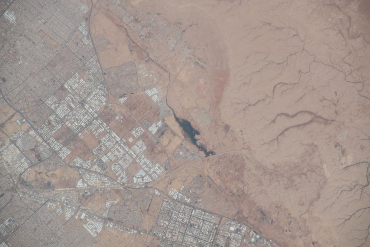
iss055e020443 (April 10, 2018) --- The southwest portion of the city of Riyadh and a body of water were pictured as the International Space Station orbited above in the desert nation of Saudi Arabia.
iss061e066577 (Dec. 3, 2019) --- This nighttime view of Dammam, Saudi Arabia, was pictured from the International Space Station as it orbited 262 miles above the middle eastern nation. The fork-like structure at right is the King Abdulaziz Seaport.
iss064e006308 (Nov. 26, 2020) --- Surrounded by the Nefud Desert, the city of Jubba, Saudi Arabia, with its abundant agriculture and plentiful water, is pictured from the International Space Station as it orbited 261 miles above.
Earth observation taken during a day pass by an Expedition 36 crew member on board the International Space Station (ISS). Per Twitter message: Riyadh, Saudi Arabia, lower right.

iss066e125410 (Jan. 24, 2022) --- The Soyuz MS-19 crew ship and the Prichal docking module (in the background) are pictured as the International Space Station orbited 258 miles above the Saudi Arabia-Iraq border.
iss059e099177 (June 10, 2019) --- The Nile River, Red Sea and Mediterranean Sea are contrasted by the desert nations of Egypt, Saudi Arabia, Israel and Jordan as the International Space Station orbits 254 miles above Africa.
iss070e097662 (Feb. 20, 2024) --- Riyadh, the capital and largest city in the desert nation of Saudi Arabia, is pictured fom the International Space Station as it orbited 260 miles above the Arabian Peninsula.
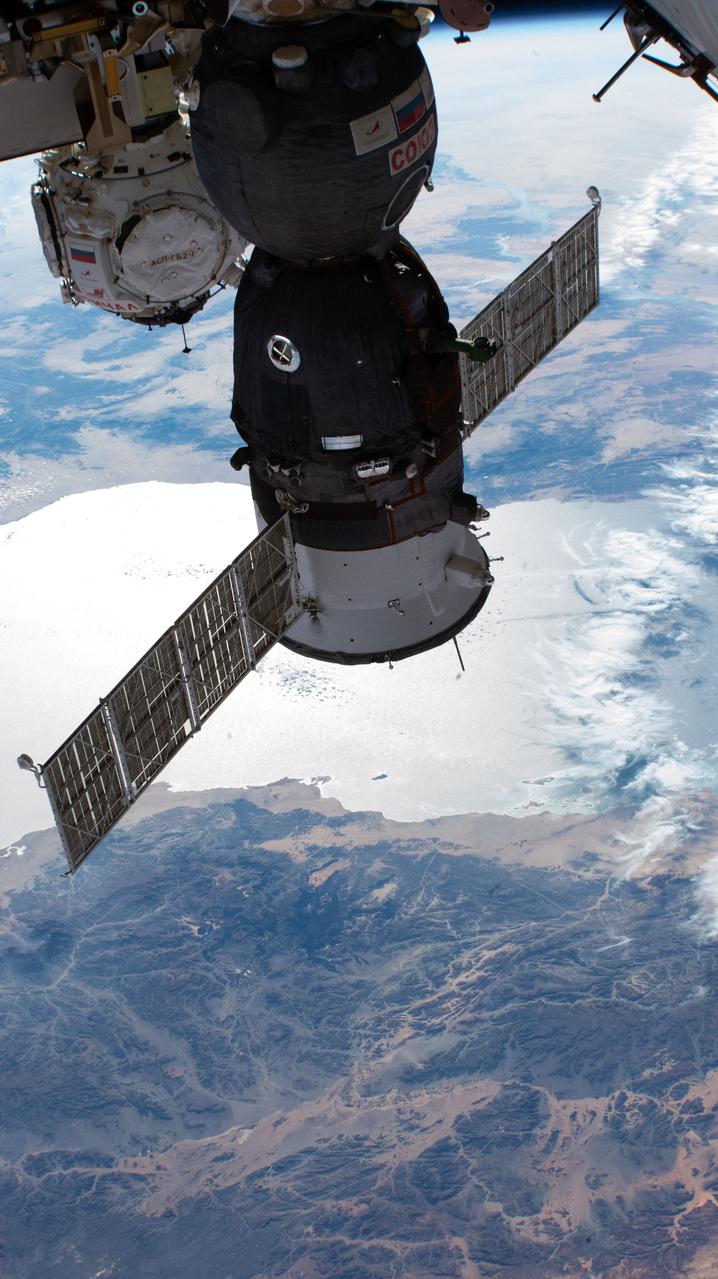
iss066e125409 (Jan. 24, 2022) --- The Soyuz MS-19 crew ship and the Prichal docking module (in the background), with the Red Sea below, are pictured as the International Space Station orbited 258 miles above Saudi Arabia.
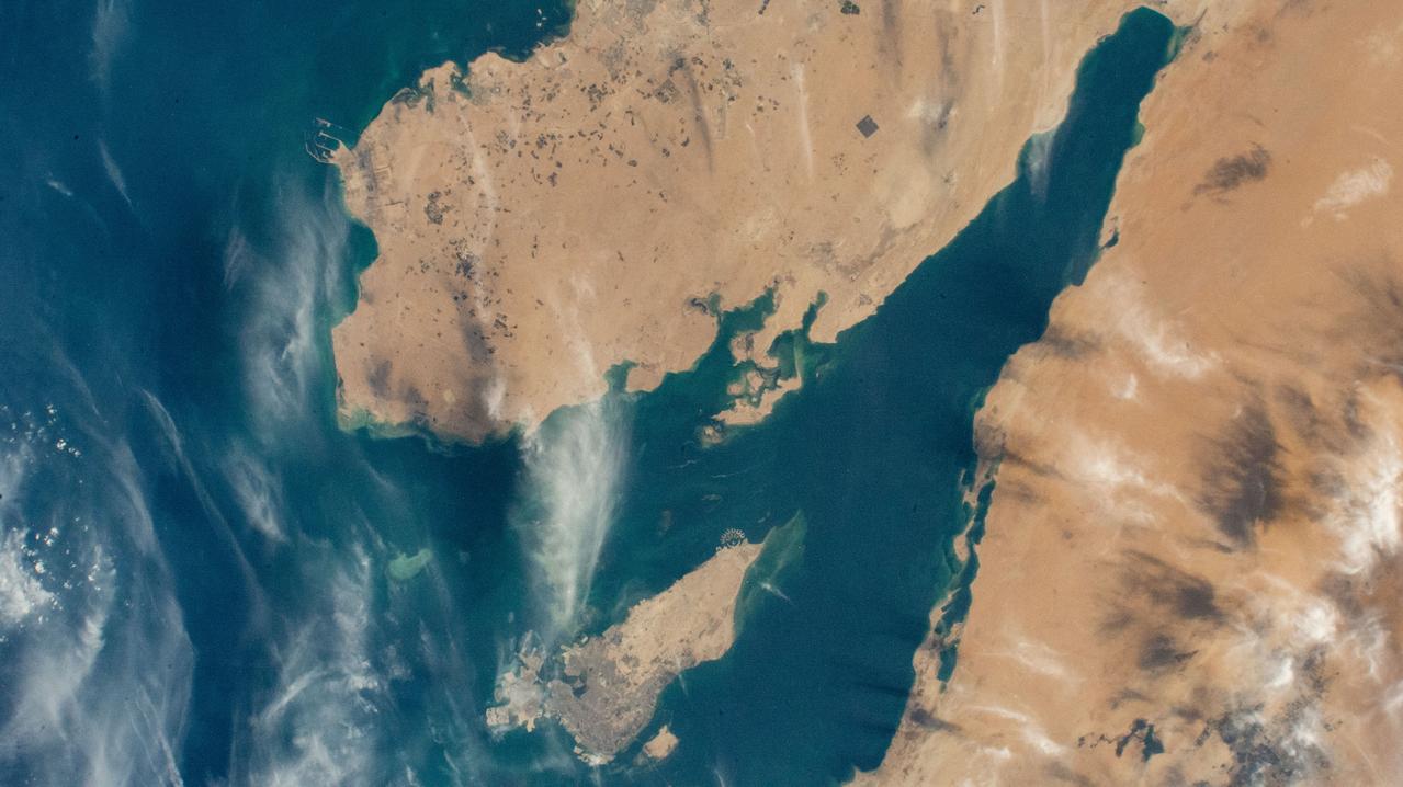
iss067e286537 (Aug. 21, 2022) --- This portion of the Hejaz region on the coast of the Red Sea, just northwest of Medina, Saudi Arabia, is pictured from the International Space Station as it orbited 257 miles above.
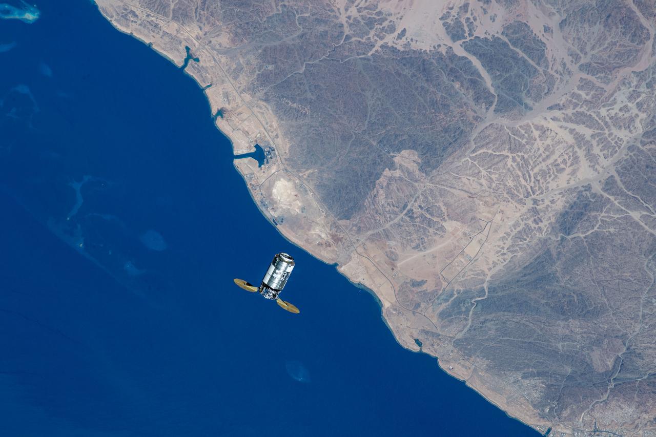
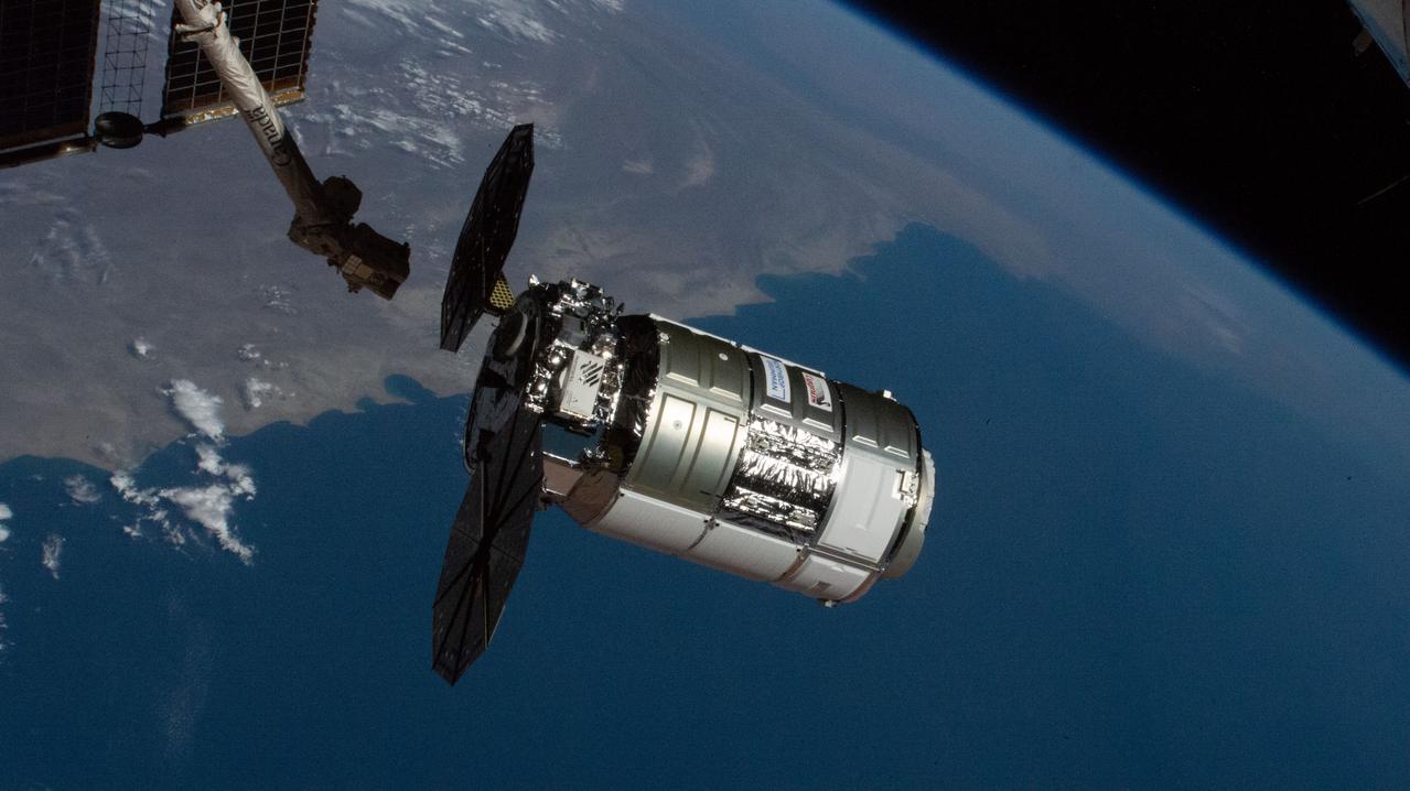
iss069e053861 (Aug. 4, 2023) --- Northrop Grumman's Cygnus cargo craft is pictured from the International Space Station as it approaches while orbiting 261 miles above the coast of the Red Sea in Saudi Arabia.
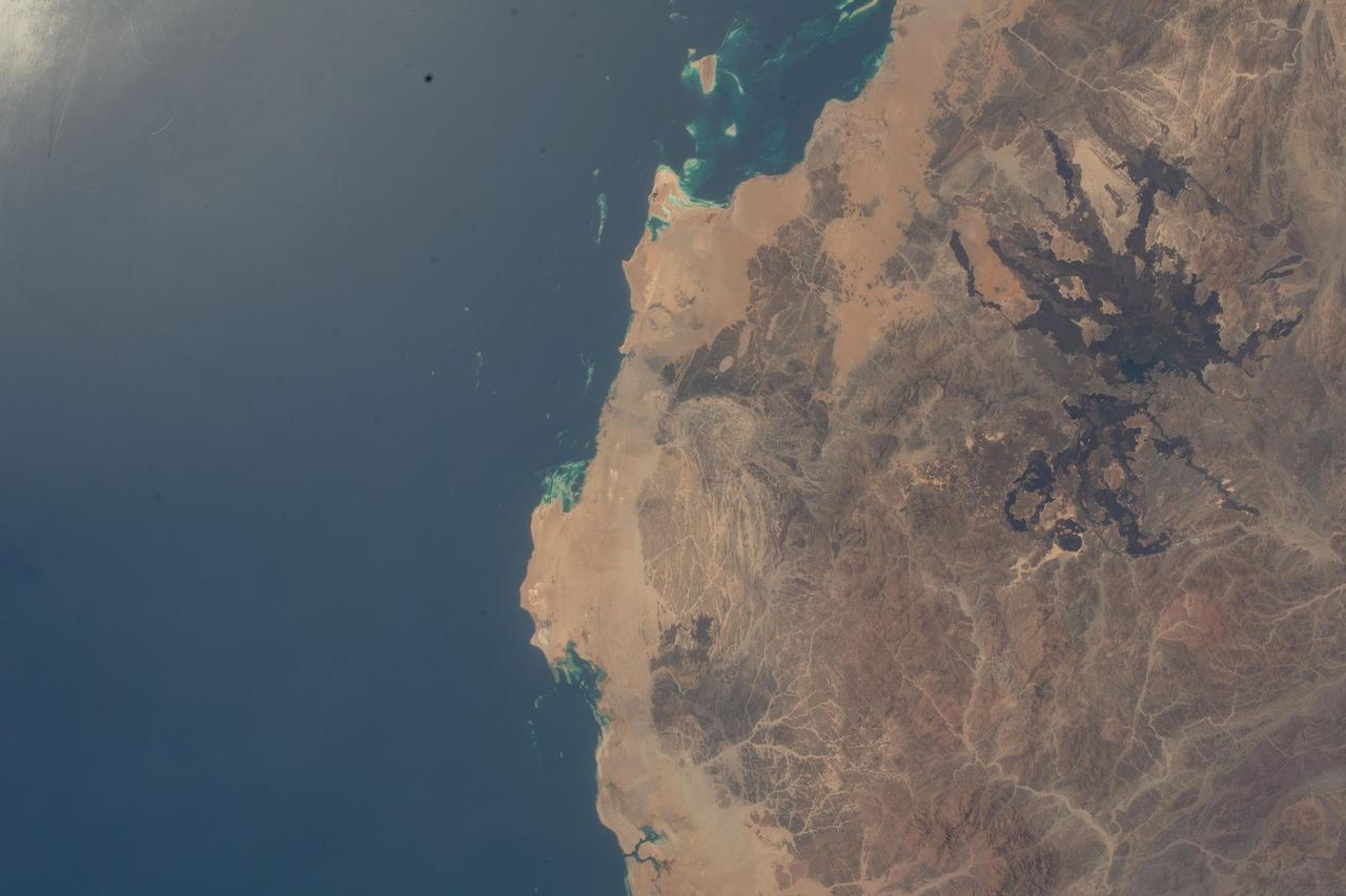
iss066e091657 (Nov. 30, 2021) --- The northwestern coast of Saudi Arabia on the Red Sea is pictured from the International Space Station as it orbited 263 miles above the Middle Eastern nation.
iss064e029305 (Feb. 3, 2021) --- This view of the Earth's horizon looks across the Red Sea and the Nile River in Africa as the International Space Station orbited 261 miles above Saudi Arabia.
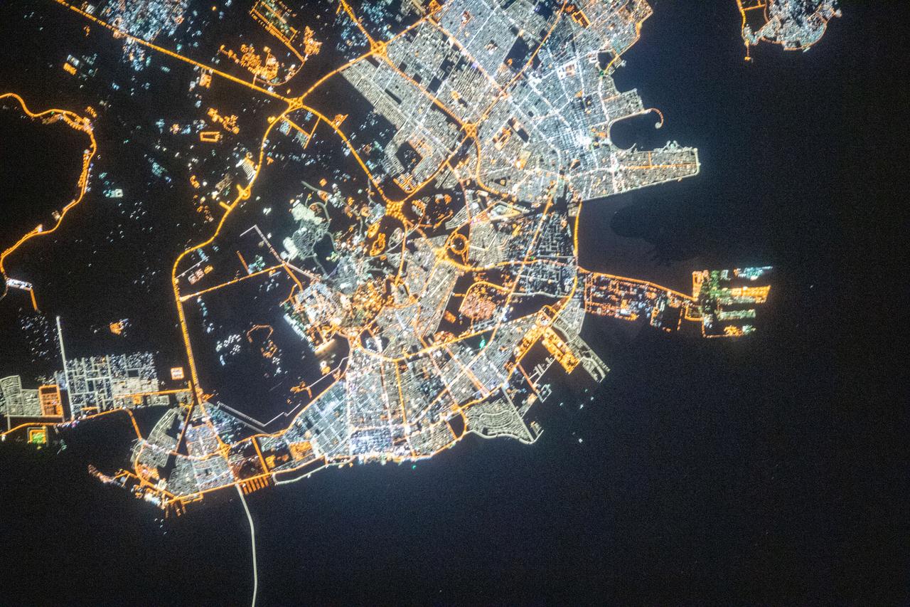
iss069e037428 (July 26, 2023) --- The city lights of Mecca, Islam's holiest city in the desert valley of western Saudi Arabia, are pictured from the International Space Station as it orbited 259 miles above.
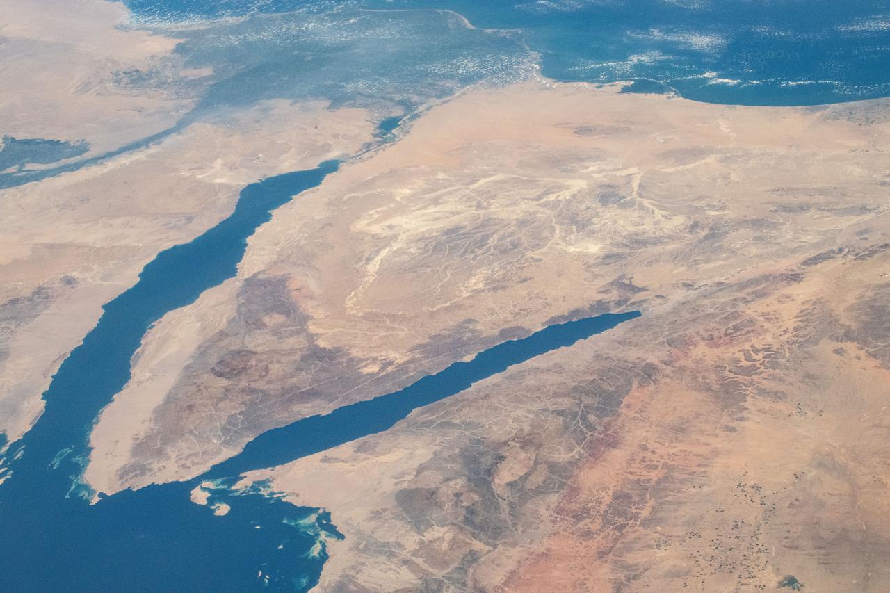
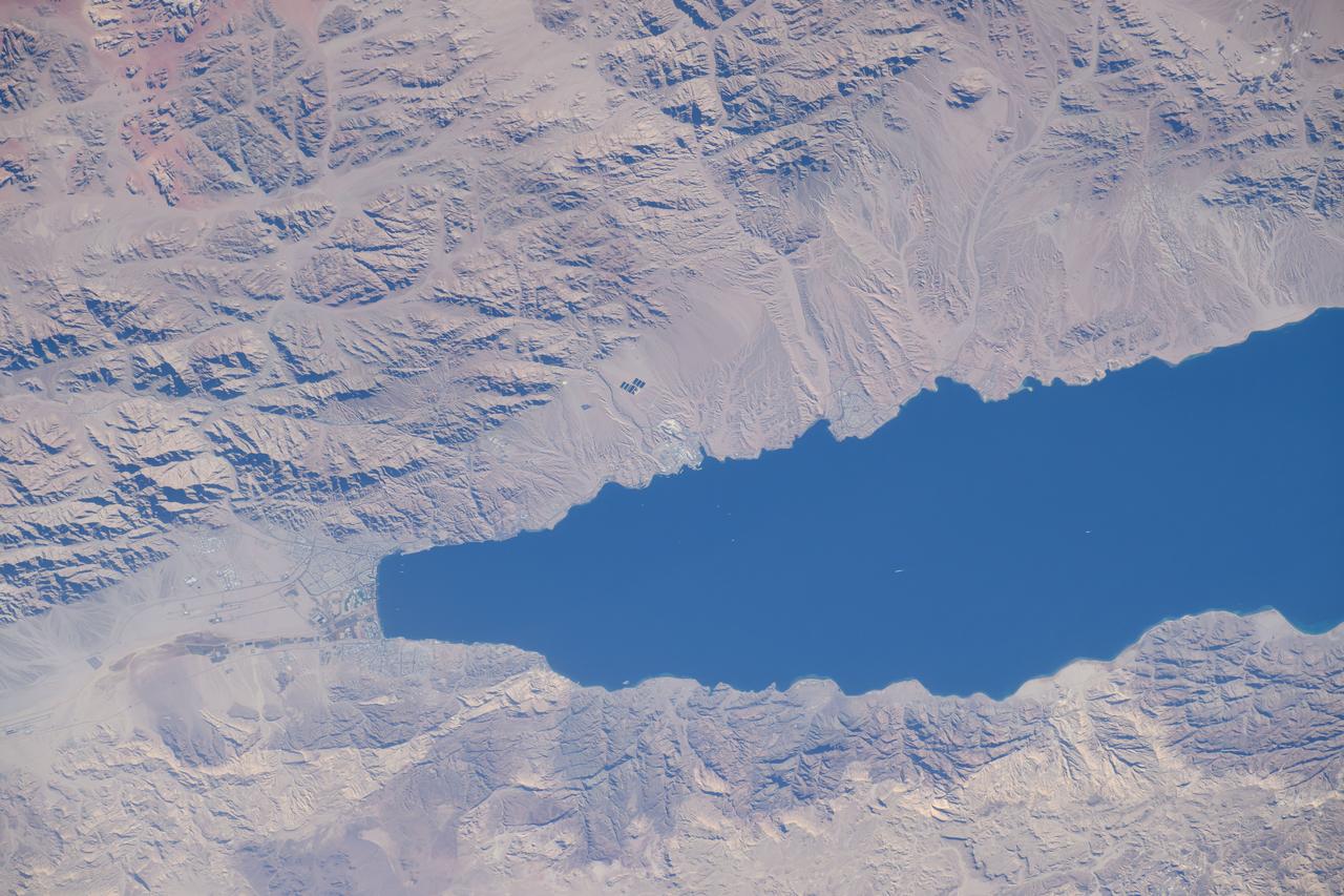
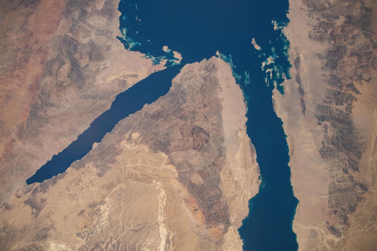
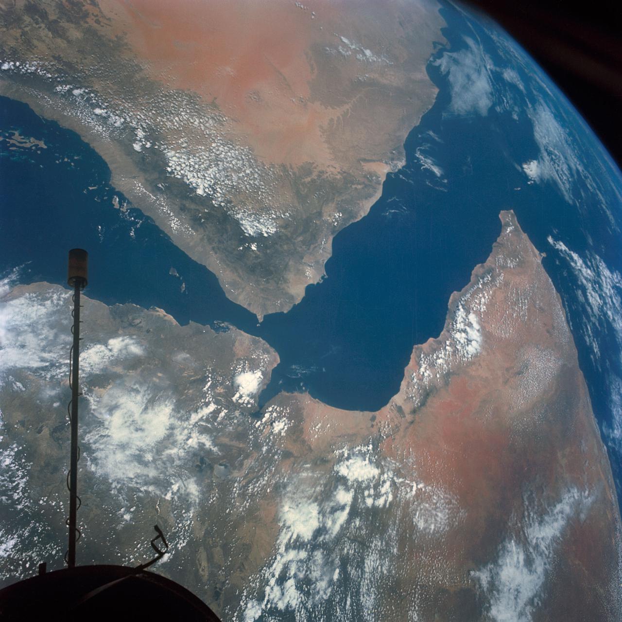
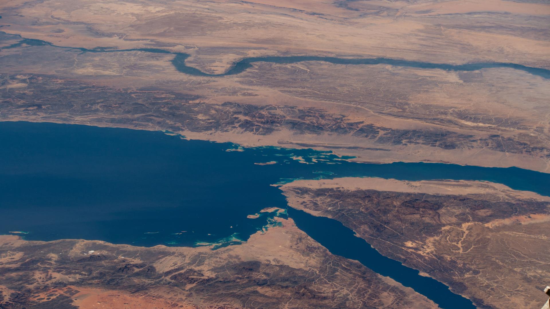
iss071e413541 (Aug. 1, 2024) -- The Gulf of Suez (left) and Gulf of Aqaba (right) flow into the Red Sea as the International Space Station orbited nearly 260 miles above Saudi Arabia.

NASA Administrator Jim Bridenstine, left, talks with Her Royal Highness Princess Reema Bandar Al Saud, Saudi Arabia’s Ambassador to the US and His Royal Highness Prince Sultan Salman Al-Saud, Chairman of the Board of Directors of the Saudi Space Commission during a courtesy visit, Monday, Aug. 12, 2019 at NASA Headquarters in Washington. Photo Credit: (NASA/Joel Kowsky)

‘NASA Administrator Jim Bridenstein, left, His Royal Highness Prince Sultan Salman Al-Saud, Chairman of the Board of Directors of the Saudi Space Commission, center, and Her Royal Highness Princess Reema Bandar Al Saud, Saudi Arabia’s Ambassador to the US, right, pose for a photograph during a courtesy visit, Monday, Aug. 12, 2019 at NASA Headquarters in Washington. Photo Credit: (NASA/Joel Kowsky)

NASA Administrator Jim Bridenstine, left, talks with Her Royal Highness Princess Reema Bandar Al Saud, Saudi Arabia’s Ambassador to the US and His Royal Highness Prince Sultan Salman Al-Saud, Chairman of the Board of Directors of the Saudi Space Commission during a courtesy visit, Monday, Aug. 12, 2019 at NASA Headquarters in Washington. Photo Credit: (NASA/Joel Kowsky)
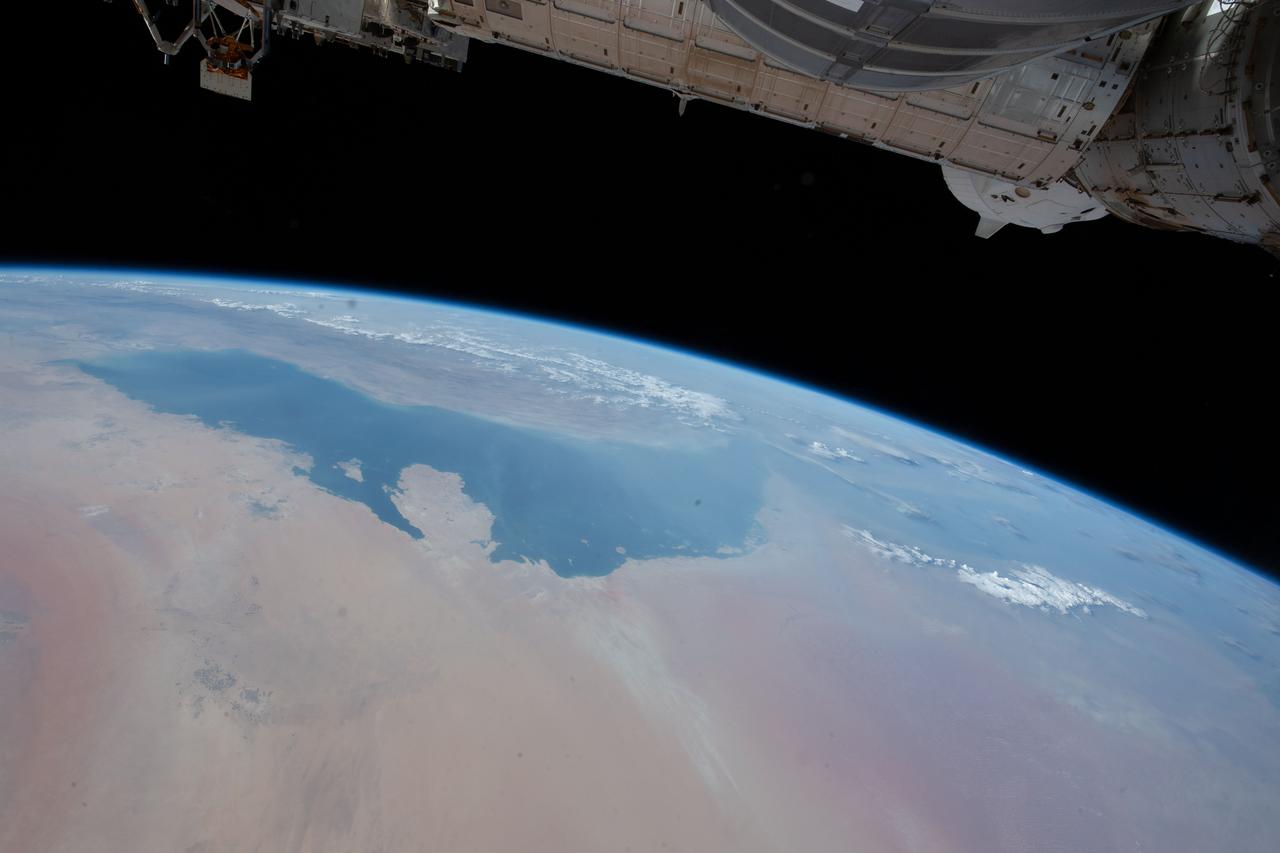
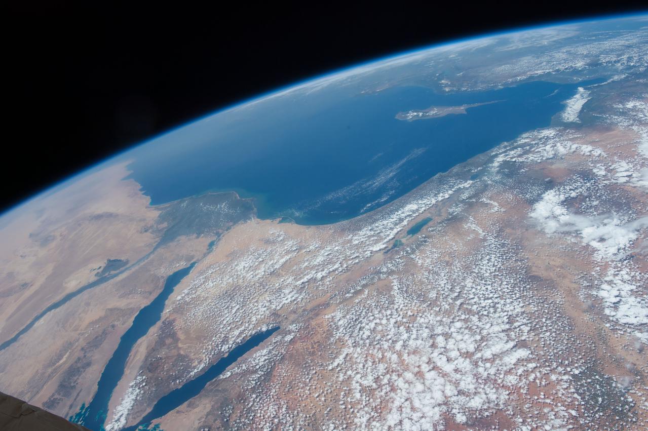
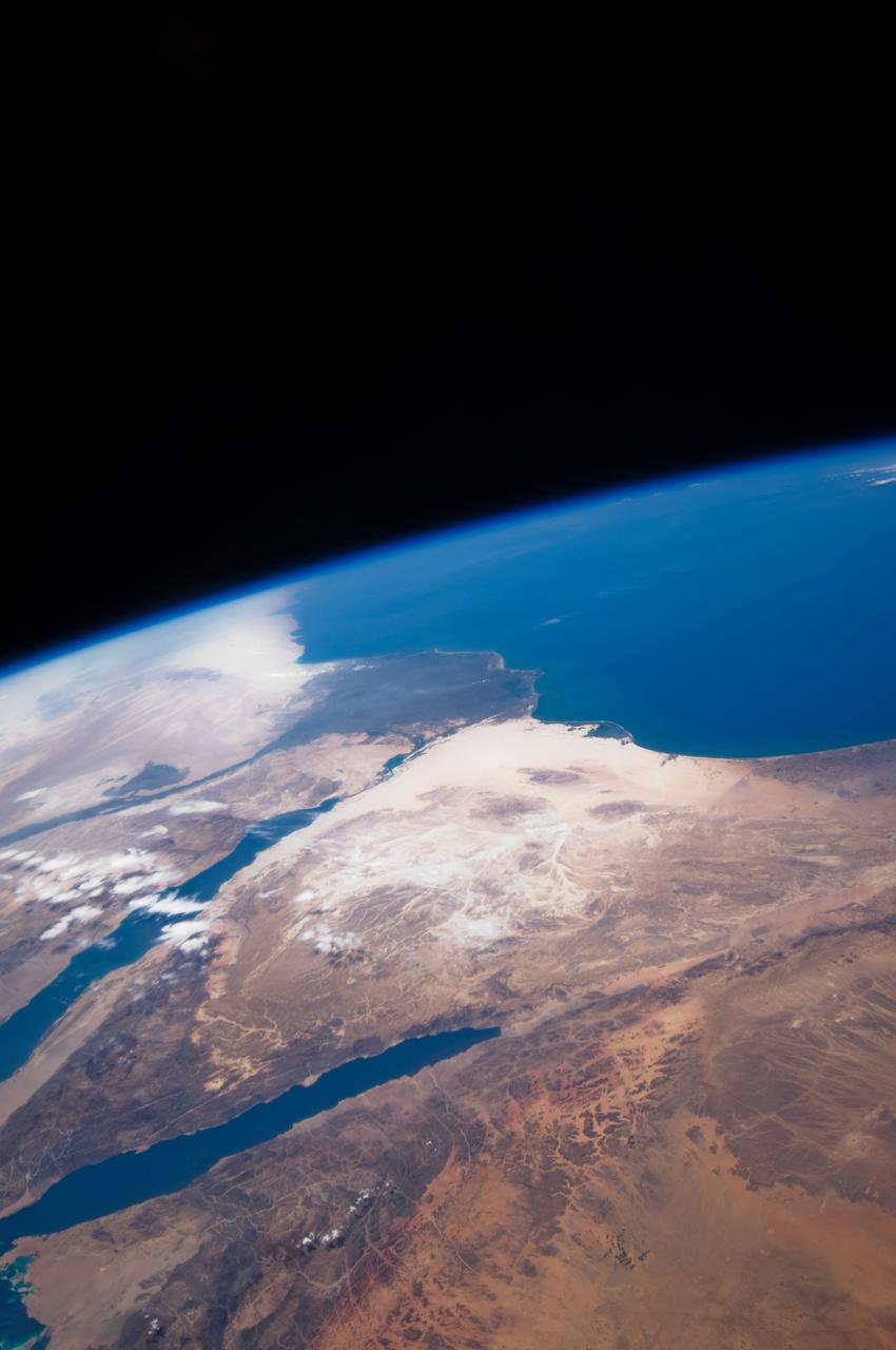
iss072e404443 (Dec. 26, 2024) --- The northern tip of the Gulf of Aqaba is surrounded by the borders of four Middle East nations, including Egypt, Israel, Jordan, and Saudi Arabia, in this photograph from the International Space Station as it orbited 261 miles above.

iss067e169952 (July 1, 2022) --- The Arvand Roud (center) is a river that separates the southern borders of Iraq and Iran on the Persian Gulf coast. At right, is the Bahmanshir River in Iran that drains into the Persian Gulf. The International Space Station was orbiting 262 miles above Saudi Arabia near the island nation of Bahrain at the time this photograph was taken.
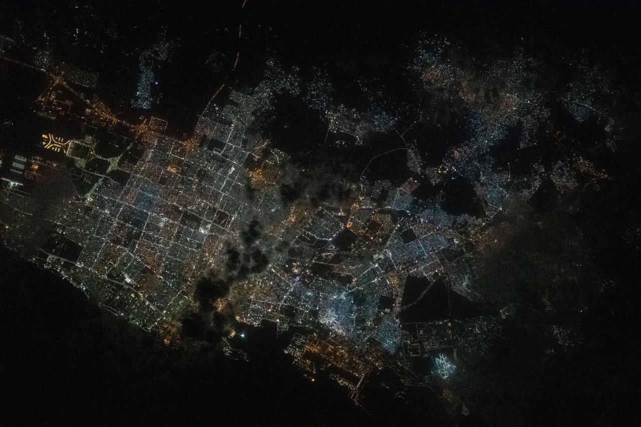
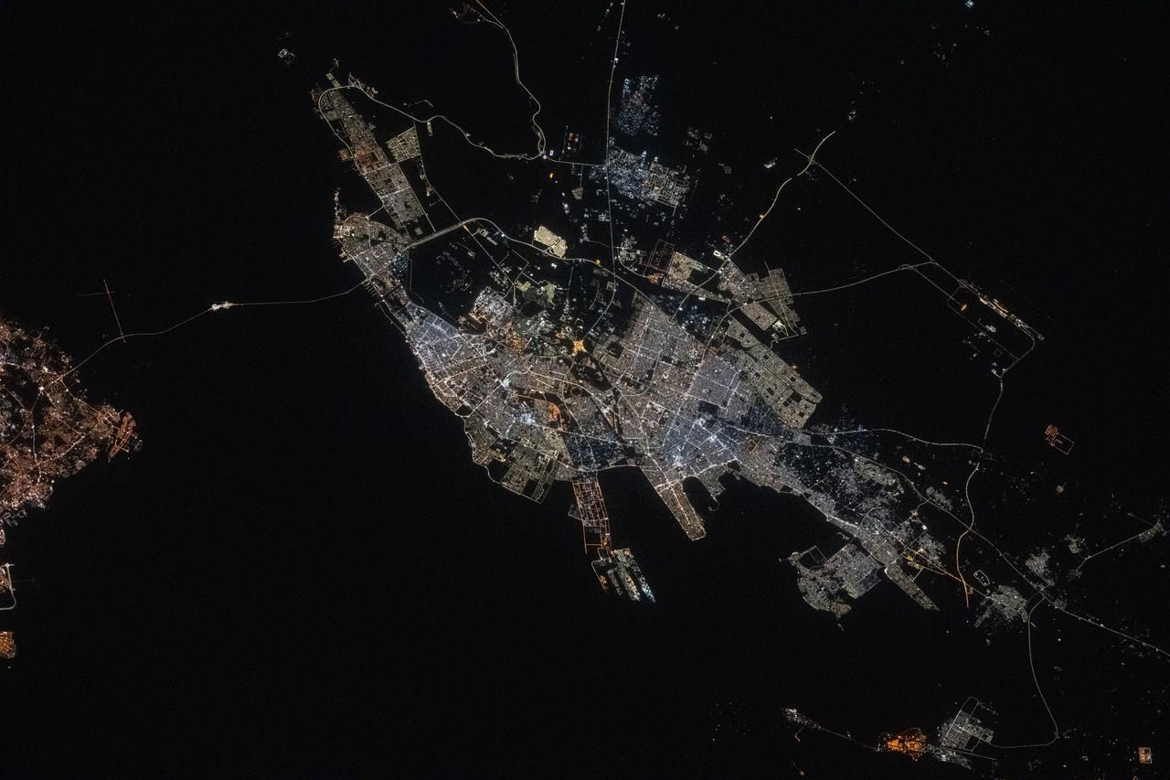
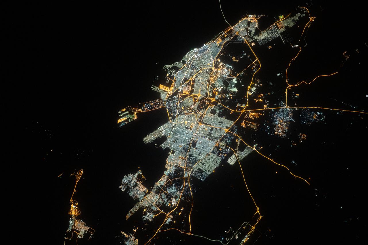
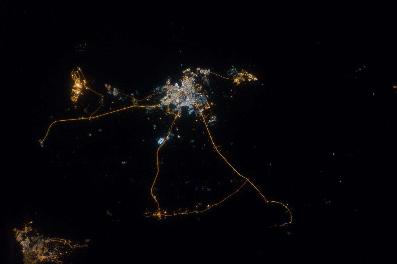
iss064e021924 (Jan. 9, 2021) ---Jeddah, Saudi Arabia, the desert nation's second-most populous city with 3.5 million residents, is pictured from the International Space Station as it orbited 261 miles above the Red Sea during a night time pass. The landmark towards the center left is the King Abdulaziz International Airport.
iss064e035906 (Feb. 22, 2021) --- The Cygnus space freighter from Northrop Grumman is pictured moments before its capture with the Canadarm2 robotic arm. Cygnus and the International Space Station were orbiting 262 miles above the United Arab Emirates-Saudi Arabia border at the time this photograph was taken.
iss063e006708 (May 5, 2020) --- The city lights of Jazan (top center) and its suburbs on the Persian Gulf coast of Saudi Arabia are easily visible from the International Space Station during an orbital night pass. Just off the coast of Jazan is the Farason Island Marine Sanctuary.
iss071e183804 (June 14, 2024) -- At the northern end of the Red Sea, the Gulf of Aqaba (left) and Gulf of Suez (right) are surrounded by the dry, rugged terrain of Egypt and Saudi Arabia. This photograph was taken as the International Space Station orbited 262 miles above.
S65-34776 (3-7 June 1965) --- This photograph shows the Nile Delta, Egypt, the Suez Canal, Israel, Jordan, Syria, Saudi Arabia, and Iraq as seen from the Gemini-Titan 4 (GT-4) spacecraft during its 12th revolution of Earth.
ISS008-E-16355 (15 February 2004) --- A massive sandstorm over the Persian Gulf state of Qatar blows southward toward southeastern Saudi Arabia and the United Arab Emirates in this image photographed by an Expedition 8 crewmember onboard the International Space Station (ISS).
ISS033-E-020299 (13 Nov. 2012) --- This nighttime photograph, taken by one of the Expedition 33 crew members aboard the International Space Station, features city lights of Riyadh, Saudi Arabia. Nadir point on Earth is located at 26.0 degrees north latitude and 47.4 degrees east longitude.
STS087-703-089 (19 November – 5 December 1997) --- Featured in this view is center pivot irrigation in central Saudi Arabia. Abundant petroleum has provided the energy source for deep-well pumps that tap groundwater stored in bedrock many thousands of years ago when the climate was much wetter. The fields are carved out of ancient alluvial fan deposits, also formed when rainfall was much greater; the fields are pushed right to the edge of the Nafud al Mazhur (sand sea), representative of the present climate. The mining of petroleum and groundwater has enabled Saudi Arabia to become an exporter of wheat and other commodities, in addition to the oil for which it is famous. This picture is one of the 70mm Earth observation visuals used by the crew at its post flight presentation events.
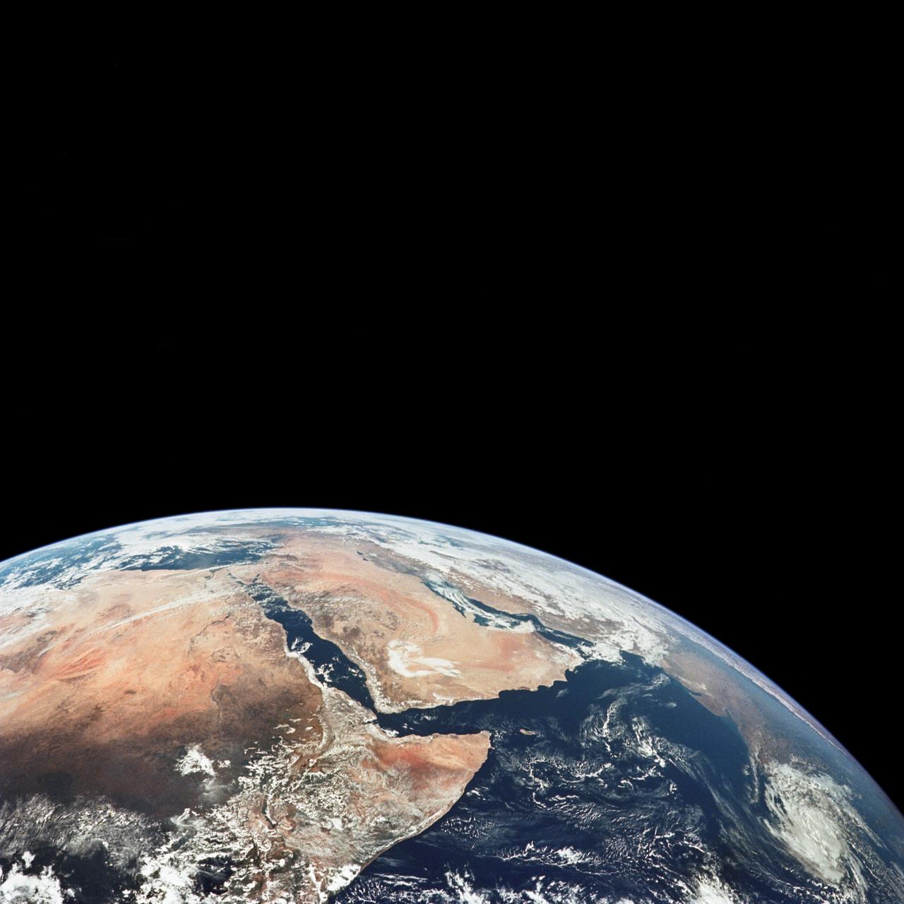
S66-54536 (14 Sept. 1966) --- Arabian Peninsula (on left) and northeast Africa (on right) as seen from the orbiting Gemini-11 spacecraft at an altitude of 340 nautical miles during its 27th revolution of Earth, looking southeast. Saudi Arabia, South Arabia, Yemen, and Aden Protectorate are at left. At bottom right is Ethiopia. French Somaliland is in center on right shore. Somali is at upper right. Body of water at bottom is Red Sea. Gulf of Aden is in center; and at top left is Indian Ocean. Taken with a modified 70mm Hasselblad camera, using Eastman Kodak, Ektachrome, MS (S.O. 368) color film. Photo credit: NASA

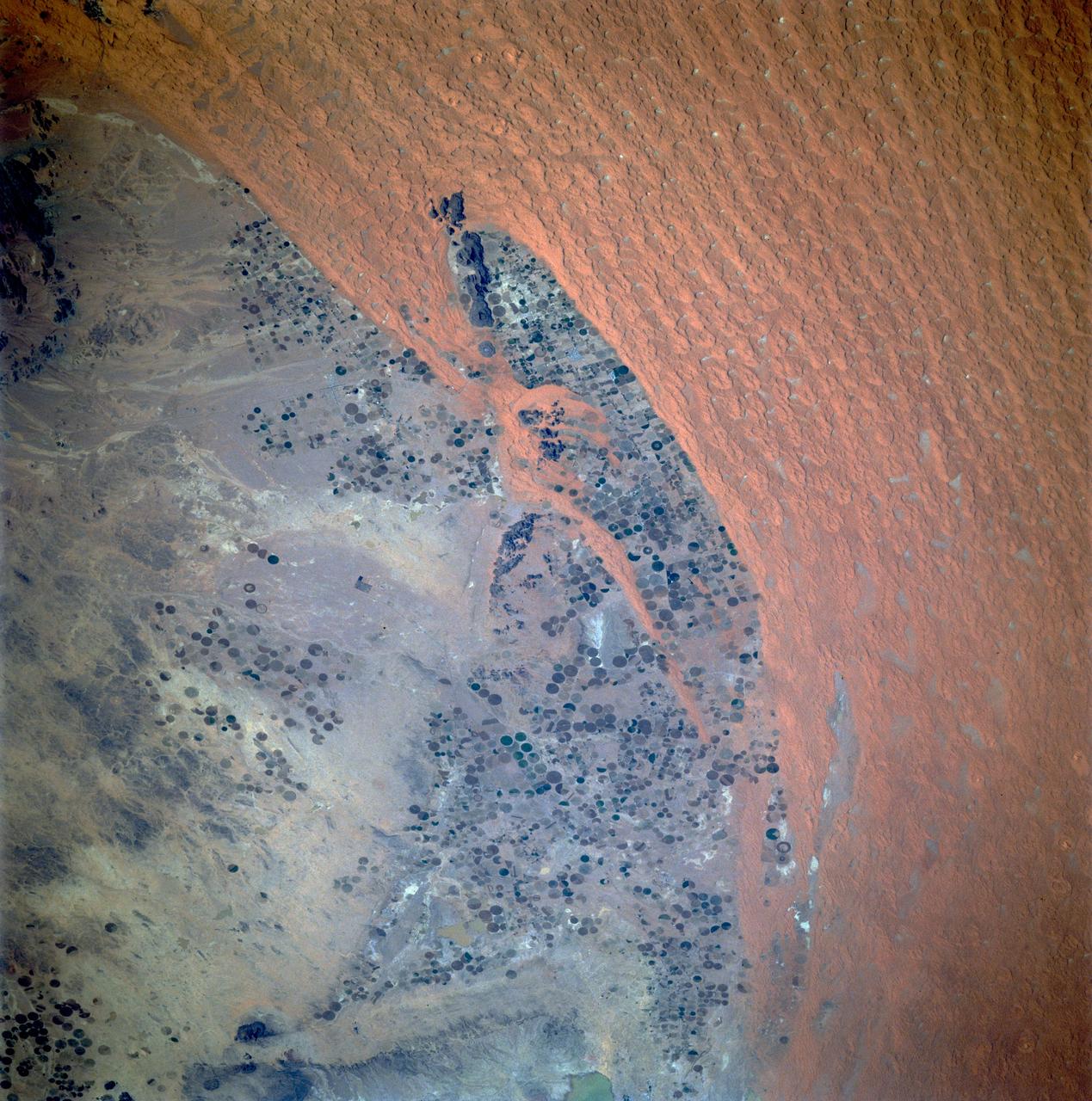
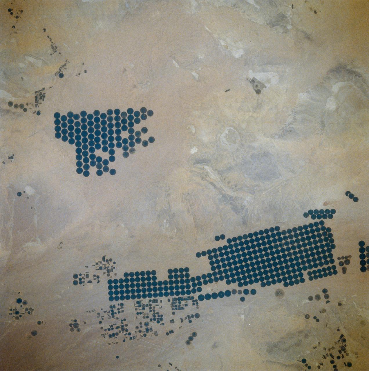
ISS030-E-090918 (21 Feb. 2012) --- Agricultural fields in the Wadi As-Sirhan Basin in Saudi Arabia are featured in this image photographed by an Expedition 30 crew member on the International Space Station. Northern Saudi Arabia hosts some of the most extensive sand and gravel deserts in the world, but modern agricultural technology has changed the face of some of them. This photograph presents the almost surreal image of abundant green fields in the midst of a barren desert ? specifically the Wadi As-Sirhan Basin of northwestern Saudi Arabia. As recently as 1986 there was little to no agricultural activity in the area, but over the subsequent 26 years agricultural fields have been steadily developed, largely as a result of investment of oil industry revenues by the Saudi government. The fields use water pumped from subsurface aquifers and is distributed in rotation about a center point within a circular field ? a technique known as center-pivot agriculture. This technique affords certain benefits relative to more traditional surface irrigation such as better control of water use and application of fertilizers. The use of this so-called ?precision agriculture? is particularly important in regions subject to high evaporative water loss; by better controlling the amount and timing of water application, evaporative losses can be minimized. Crops grown in the area include fruits, vegetables, and wheat. For a sense of scale, agricultural fields in active use (dark green) and fallow (brown to tan), are approximately one kilometer in diameter. While much of the Wadi As-Sirhan Basin shown here is sandy (light tan to brown surfaces) and relatively flat, low hills and rocky outcrops (dark gray) of underlying sedimentary rocks are visible at left and right.
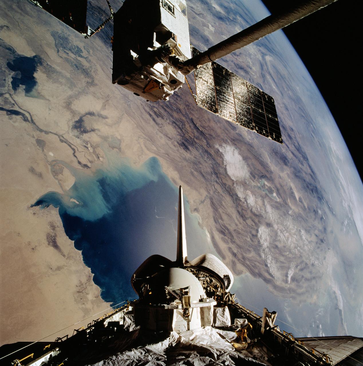
STS046-102-021 (1 Aug 1992) --- The European Space Agency's (ESA) EURECA satellite remains in the grasp of the Space Shuttle Atlantis' Remote Manipulator System (RMS) as the Space Shuttle passes over the Persian Gulf. Most of the theater of the recent war is visible in the frame. Parts of Kuwait, Iraq, Iran and Saudi Arabia can be delineated. The Tethered Satellite System (TSS) remains stowed in the aft cargo bay of Atlantis.
ISS047e057822 (04/14/2016) --- The Middle East is seen from 250 miles above in this photo from the International Space Station. Countries seen left to right along the Mediterranean coast include Egypt, Gaza, Saudi Arabia, Israel, Lebanon, Syria, and Turkey. The major waterways shown from left to right are the Nile River, Gulf of Suez, Gulf of Aqaba, and the Red Sea.
iss067e169965 (July 1, 2022) --- The Khawr az-Zubayr Waterway (at bottom) separates the Middle Eastern nations of Kuwait and Iraq on the Persian Gulf coast. At top left, is the desert town of Abdali, Kuwait. At right, is the fertile, agricultural town of Abu Al-Khaseeb, Iraq. The International Space Station was orbiting 262 miles above Saudi Arabia near the island nation of Bahrain at the time this photograph was taken.
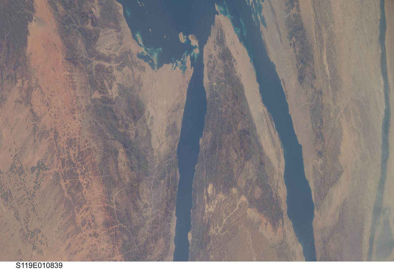
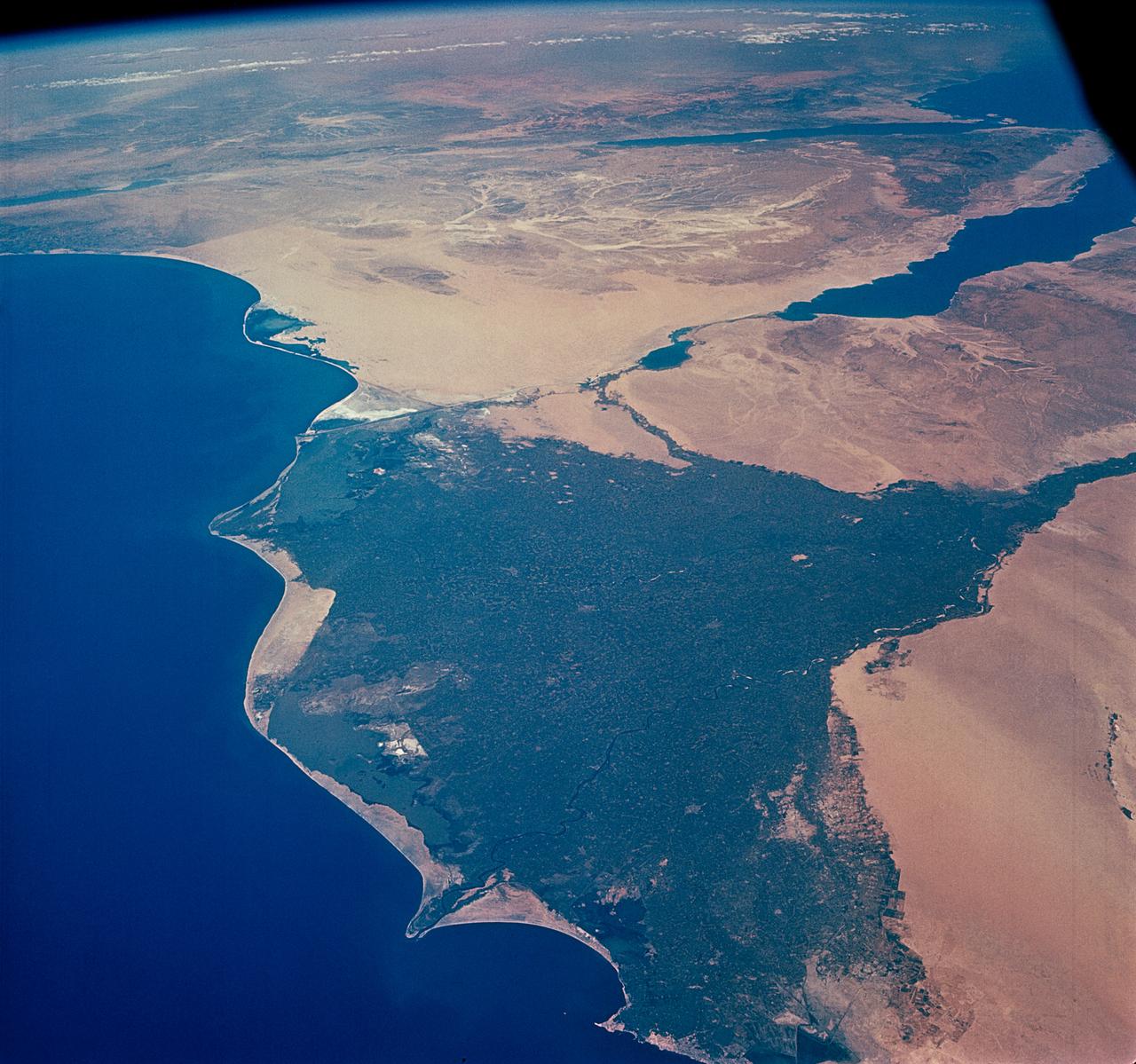
S119-E-010839 (27 March 2009) --- On its final full day in space before its scheduled return home on March 28, the crew of Space Shuttle Discovery took some pictures of the home planet, including this one of the Sinai Peninsula. The frame shows part of the Red Sea (top), Gulf of Suez (right of center), Nile River (far right edge), Gulf of Aqaba (center frame) and parts of the nations of Egypt, Jordan and Saudi Arabia.

STS080-733-021 (19 Nov.-7 Dec. 1996) --- The crewmembers of the Earth-orbiting space shuttle Columbia took this view that shows Kuwait City (mid-center right and along the coastal area), most of Kuwait, portions of Saudi Arabia, and Iraq. Faylakah Awhah Island is seen in the Persian Gulf to the bottom right. Most of the darkened areas represent the residual from oil well fires during the Gulf War of the early 1990?s.
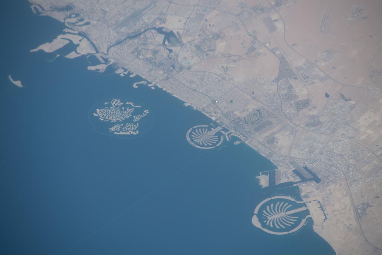
iss059e078929 (May 29, 2019) --- The artificial islands off the coast of Dubai in the United Arab Emirates are known as (from left) The World Islands, Palm Jumeirah and Palm Jebel Ali. The International Space Station was orbiting 255 miles above Saudi Arabia about to cross the Persian Gulf when this photograph was taken by an Expedition 59 crewmember.
ISS008-E-18935 (24 March 2004) --- This photo of a large black smoke plume from an oil fire was taken by an Expedition 8 crewmember on the International Space Station as the Station orbited northeastward across Saudi Arabia. According to a front-page story in the New York Times, an oil pipeline near the channel of Shatt al Arab in southeastern Iraq on the Persian Gulf ruptured the day before. The resulting oil spill ignited and its smoke can here be seen to extend over 100 miles northwestward into southern Iraq.
iss064e021961 (Jan. 9, 2021) --- Kuwait City is pictured during a night time pass from the International Space Station as it orbited 261 miles above the Iraq-Saudi Arabia border. Towards the bottom left, is the Sheikh Jaber Al-Ahmad Al-Sabah Causeway, the world's fourth longest road bridge at 24.5 miles, that crosses Kuwait Bay.
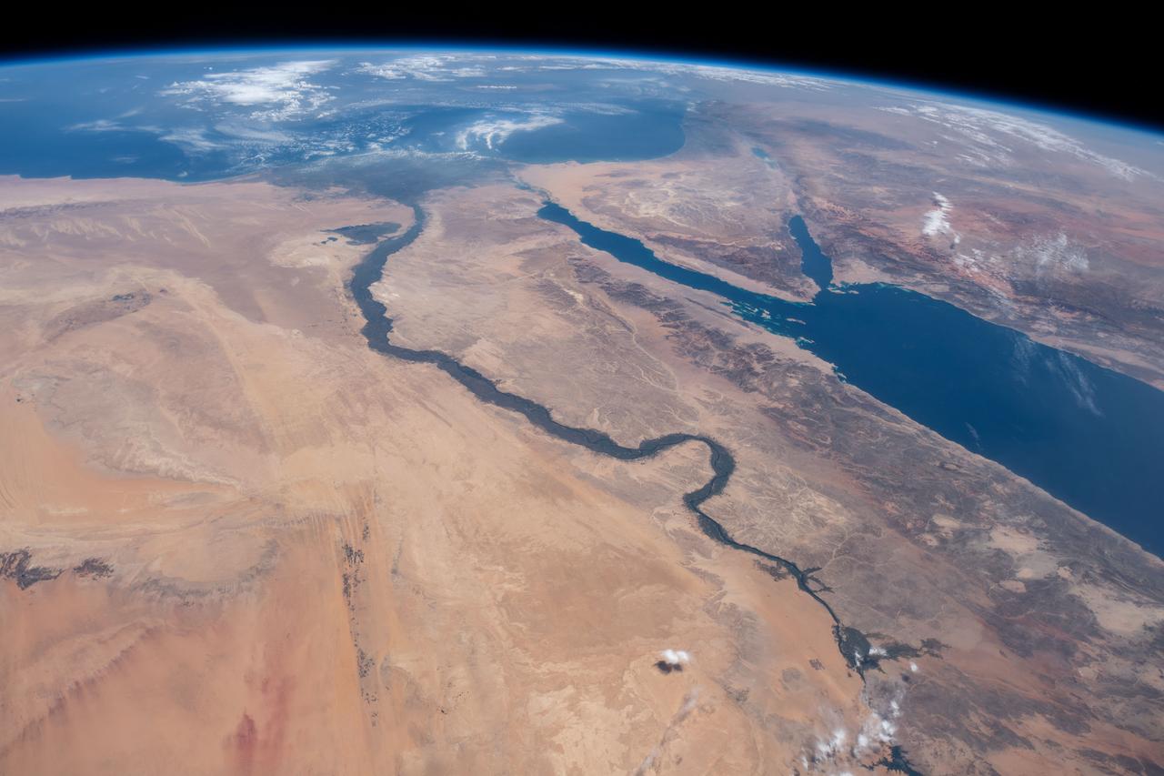
iss073e0768775 (Sept. 26, 2025) --- The Nile River (top) winds through Egypt, which is separated from Saudi Arabia by the Red Sea. The Red Sea branches into two gulfs: the Gulf of Suez, which leads to the Suez Canal—a strategic and economically vital waterway—and the Gulf of Aqaba. The International Space Station was orbiting 257 miles above the Middle East when this photograph was taken.
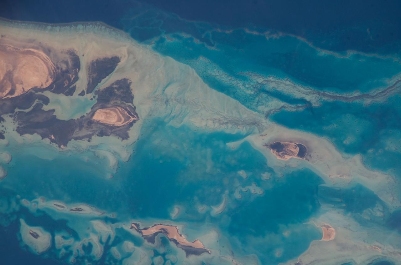
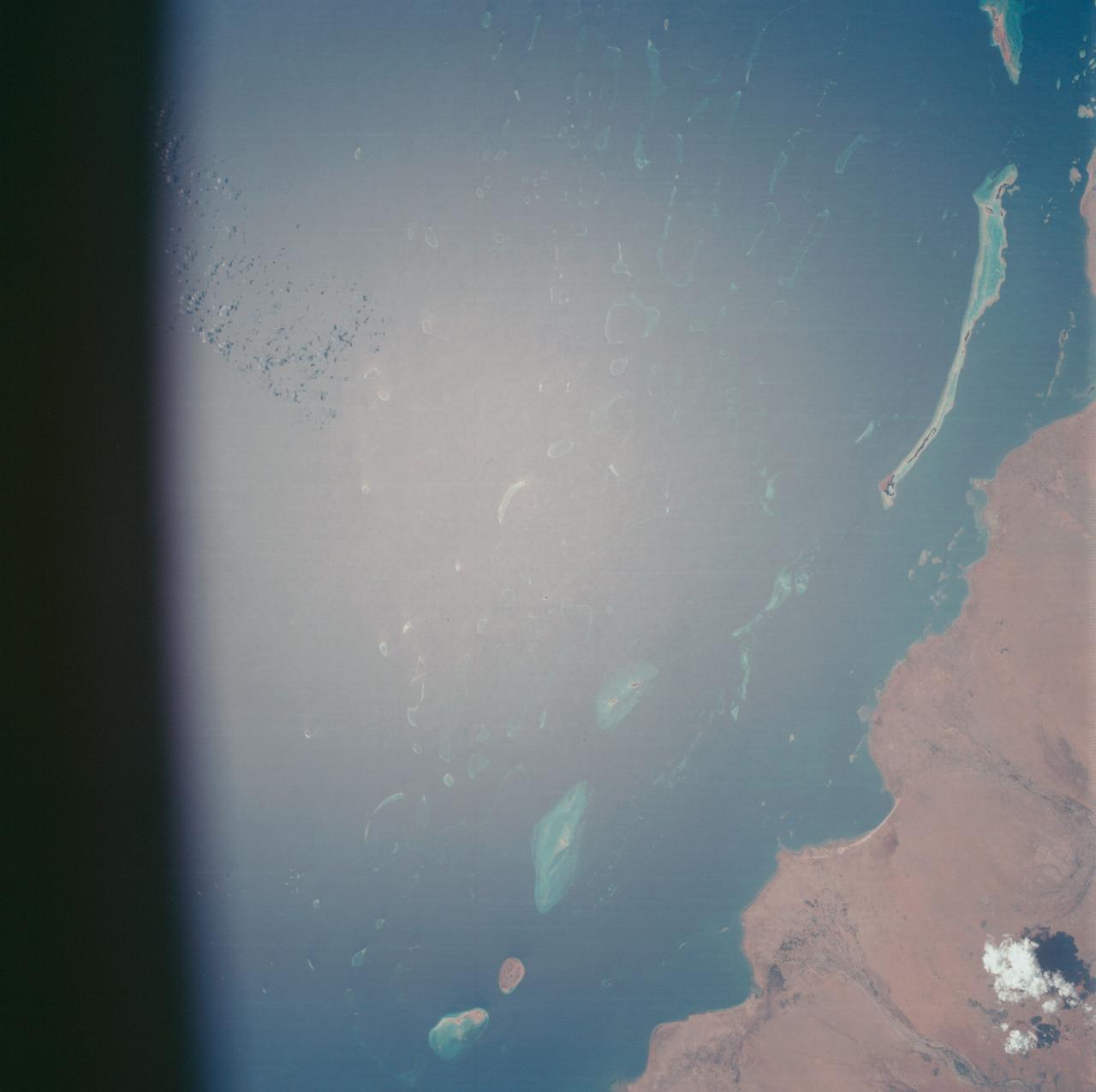
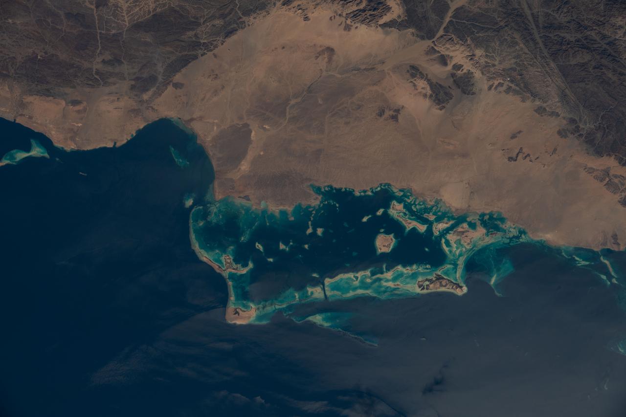
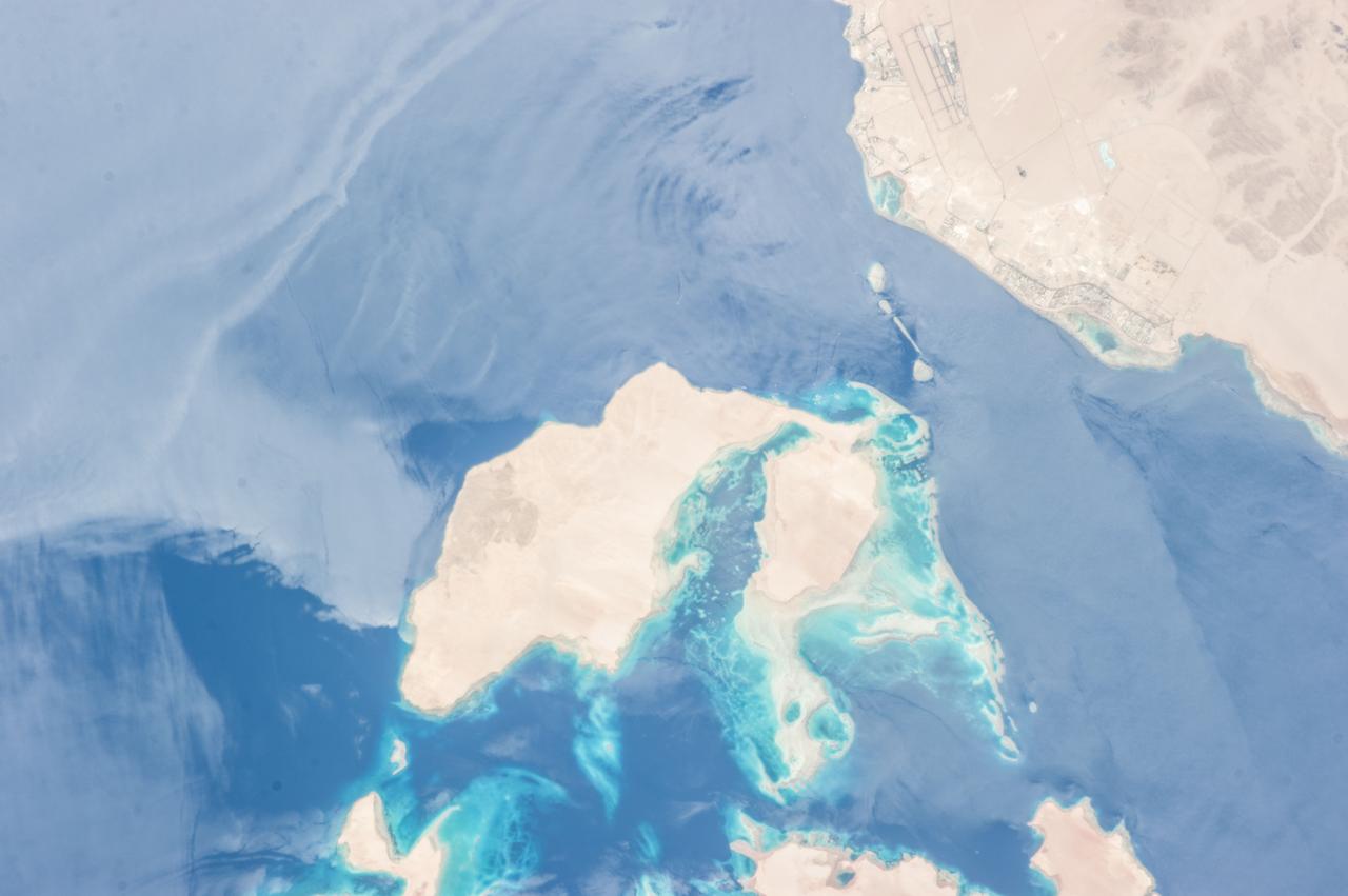
ISS016-E-019394 (30 Dec. 2007) --- Al Wadj Bank, Saudi Arabia is featured in this image photographed by an Expedition 16 crewmember on the International Space Station. Saudi Arabia boasts the most coral reefs of any Middle Eastern country, as it includes coastline along both the Red Sea and Gulf of Arabia. This high resolution image depicts a portion of the Al Wadj Bank, located along the northern Red Sea coast. Despite the relatively high salinity of Red Sea water (compared to other oceans), approximately 260 species of coral are found here, according to scientists. Large tracts of the Saudi Arabian coastline are undeveloped, and reefs in these areas are in generally good ecological health. However, reefs located near large urban centers like Jeddeh have suffered degradation due to land reclamation, pollution, and increased terrigeneous sediment input. The Al Wadj Bank includes a healthy and diverse reef system, extensive seagrass beds, and perhaps the largest population of dugong -- a marine mammal similar to the North American manatee -- in the eastern Red Sea. The portion of the Bank in this image illustrates the complex form and topography of the reef system. Several emergent islands (tan) - surrounded primarily by dark green seagrass - are visible, the largest located at top left. Only the islands are above the waterline -- over the reef structures the water color ranges from light teal (shallow) to turquoise (increasing depth). The southern edge of the reef is well indicated by the deep, dark blue water of the Red Sea at image top.
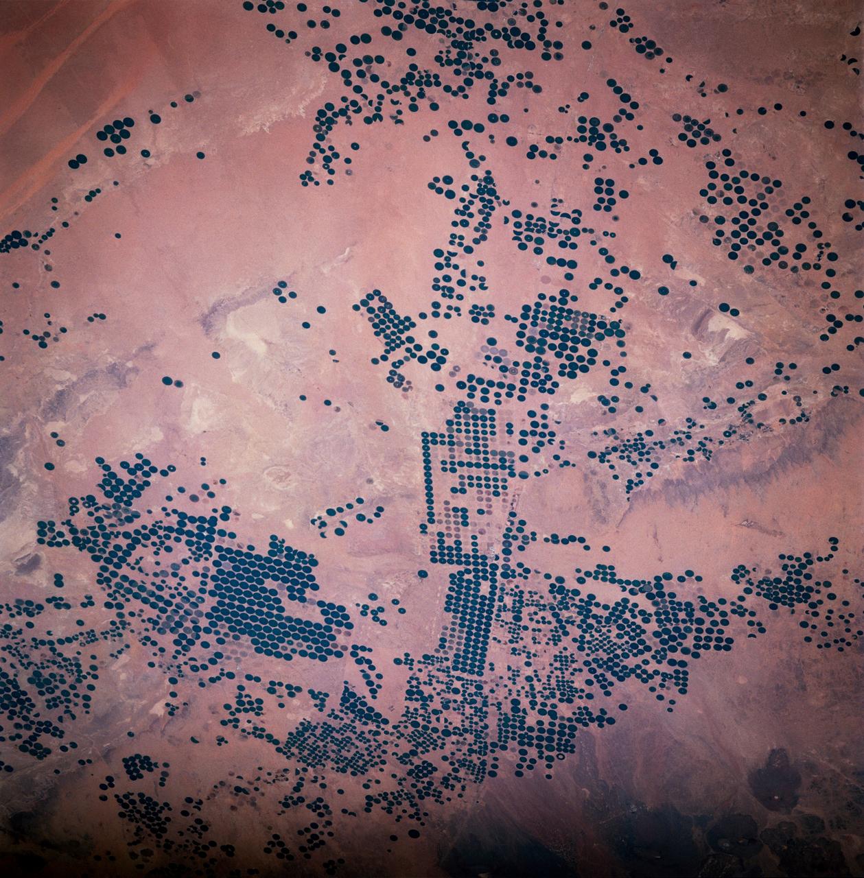
STS083-747-033 (4-8 April 1997) --- Center Pivot Irrigation, in Saudi Arabia. This irrigation project in Saudi Arabia is typical of many isolated irrigation projects scattered throughout the arid and hyper-arid regions of the Earth. Fossil water is mined from depths as great as 3,000 feet, pumped to the surface, and distributed via large center pivot irrigation feeds. The circles of green irrigated vegetation may comprise a variety of agricultural commodities from alfalfa to wheat. Diameters of the normally circular fields range from a few hundred meters to as much as 2 miles. The projects often trace out a narrow, sinuous, and seemingly random path. Actually, engineers generally seek ancient river channels now buried by the sand seas. The fossil waters mined in these projects accumulated during periods of wetter climate in the Pleistocene glacial epochs, between 10,000 to 2 million years ago, and are not being replenished under current climatic conditions. The projects, therefore, will have limited production as the reservoirs are drained. Water, of course, is the key to agriculture in Saudi Arabia. The Kingdom has implemented a multifaceted program to provide the vast supplies of water necessary to achieve the spectacular growth of the agricultural sector. A network of dams has been built to trap and utilize precious seasonal floods. Vast underground water reservoirs have been tapped through deep wells. Desalination plants have been built to produce fresh water from the sea for urban and industrial use, thereby freeing other sources for agriculture. Facilities have also been put into place to treat urban and industrial run-off for agricultural irrigation. These efforts collectively have helped transform vast tracts of the desert into fertile farmland. Land under cultivation has grown from under 400,000 acres in 1976 to more than 8 million acres in 1993.
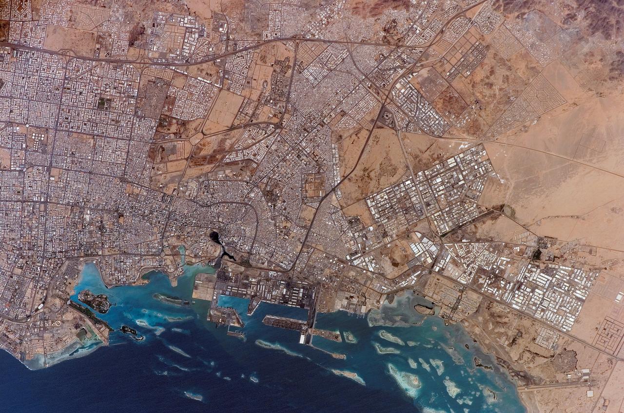
ISS010-E-20261 (19 March 2005) --- Jeddah, Saudi Arabia is featured in this image photographed by an Expedition 10 crewmember on the International Space Station. The city of Jeddah is the second largest city in Saudi Arabia (after Riyadh), and is the country’s most important Red Sea port. A large warehouse and dock complex is visible in the lower left portion of this image. Apart from being a major port for exchange of goods with Africa and Europe, Jeddah is of great importance for Islamic pilgrims going east to Mecca (a religious journey known as the hajj). In addition to urban attractions, coral reefs along the coast (north-south trending islands to image left) are frequented by divers visiting the city. The image captures the multicolored rooftops of homes and other buildings in the city, the oldest of which were built using coral from the nearby Red Sea and clay from the al-Manqabah lagoon in the center of the Al Balad district (center of image; lagoon is approximately 0.25 km across).
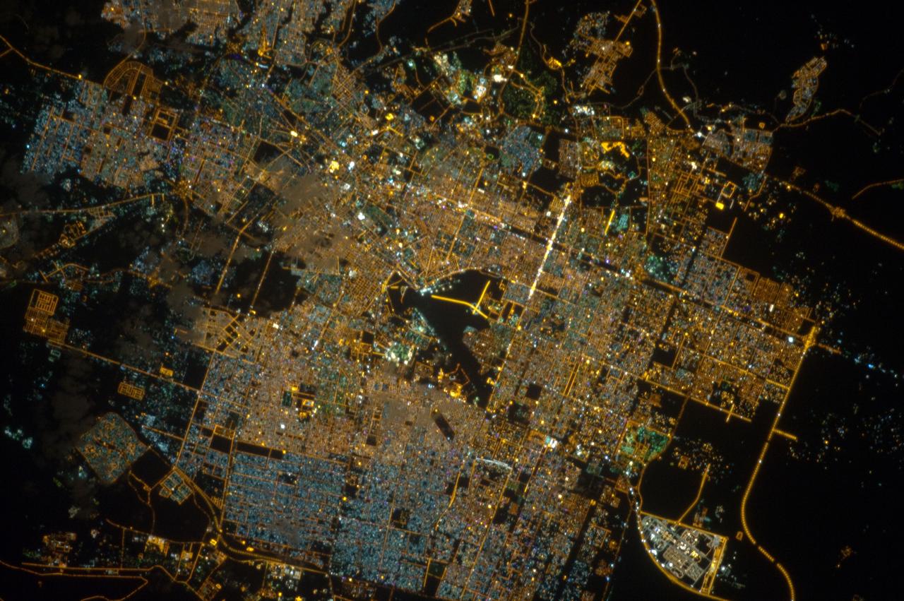
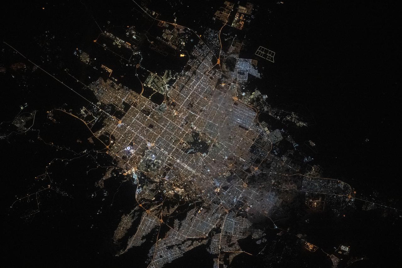
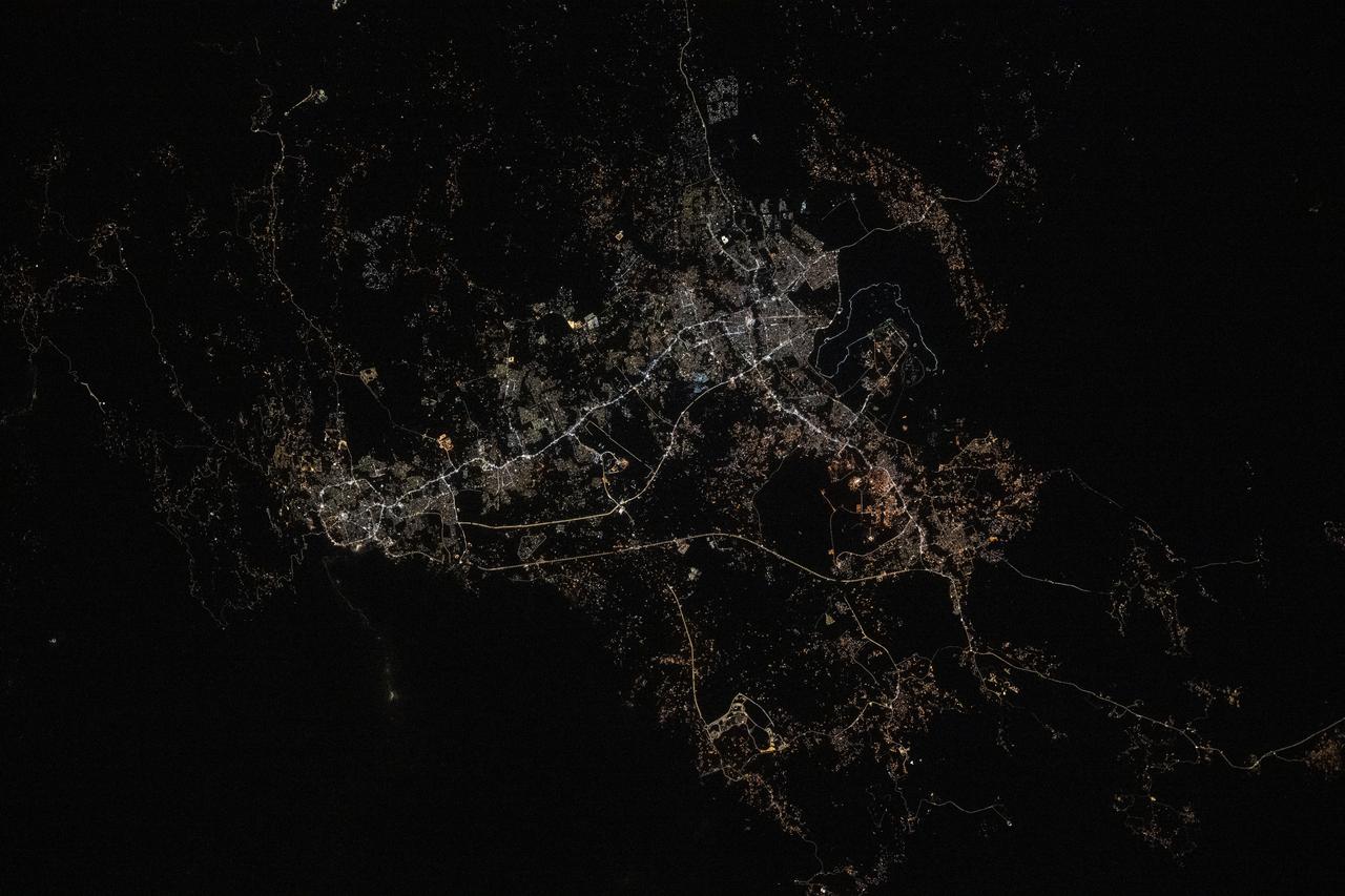
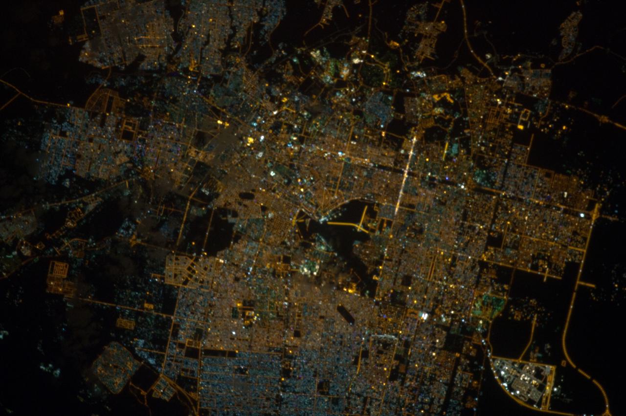
ISS033-E-020288 (13 Nov. 2012) --- A nighttime view of Riyadh, Saudi Arabia is featured in this image photographed by an Expedition 33 crew member on the International Space Station. The population of Riyadh, the capital city of Saudi Arabia, has risen dramatically in the last half century, from 150,000 in 1960 to an estimated 5.4 million in 2012. The city appears as a brightly colored patchwork in this nighttime photograph. The brightest lights, apart from those on the old Riyadh Airbase at center (the new international airport is far outside the city and not shown here), follow the commercial districts along King Abdullah Road and King Fahd Branch Road. Many of the darker patches within the built area are city parks. University sectors stand out with different street and light patterns, as seen in the King Saud University campus which houses the Arabic Language Institute, and the Princess Nora Bint Abdul Rahman University which is the largest all-female university in the world. Highways and various ring roads also stand out in night imagery due to bright regular lighting. Lighted developments beyond the ring roads mark the growth of the city. Newer neighborhoods, set further from the city center, are recognizable by blue-gray lightning.
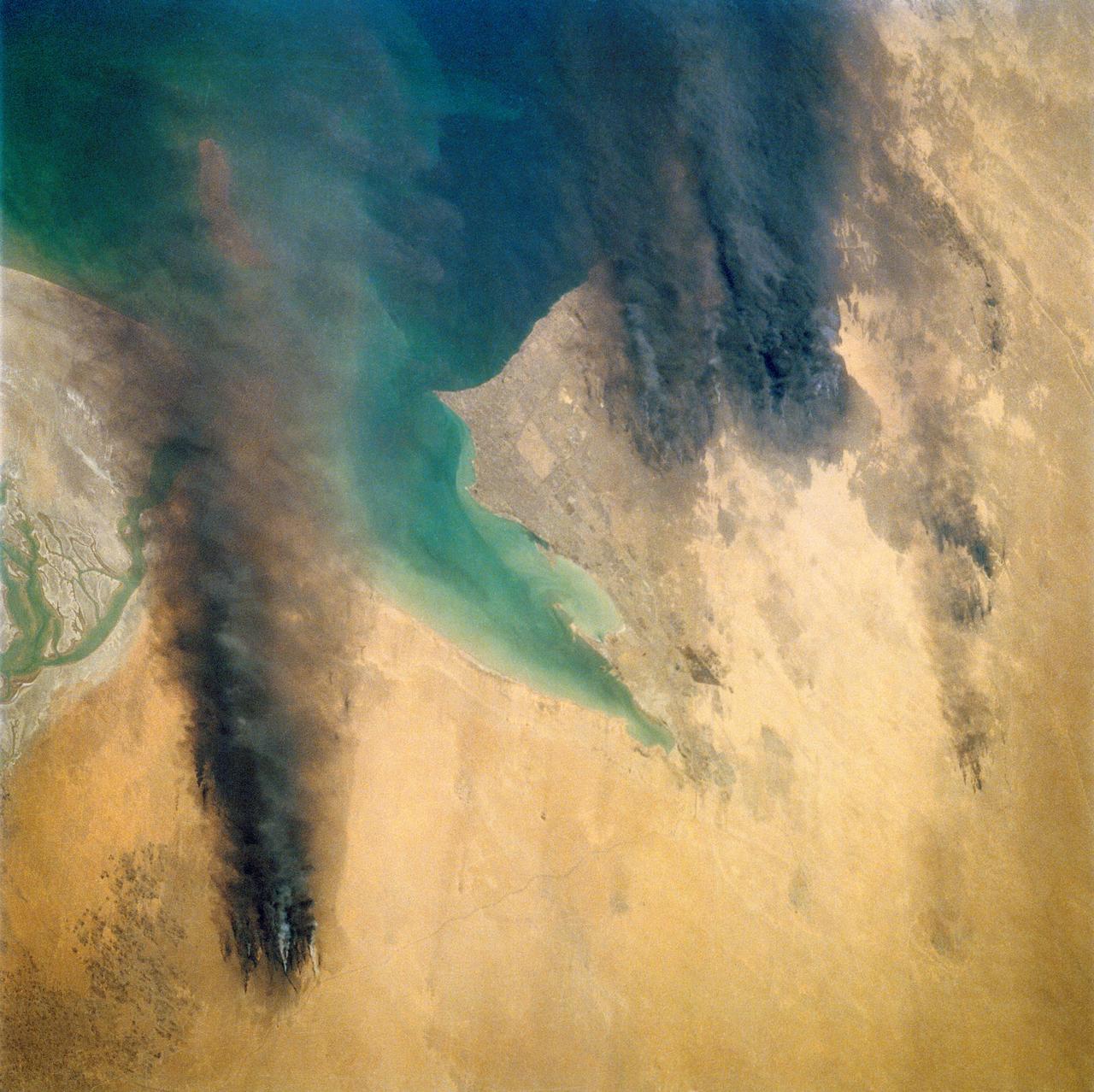
STS039-72-060 (28 April-6 May 1991) --- This view from the Earth-orbiting Space Shuttle Discovery shows the smoke from burning oil well fires, aftermath of Iraqi occupation. Oil wells to the north of the Bay of Kuwait and just south of Kuwait City, on the south shore, can be seen burning out of control. Compared with pictures of the same area shot during STS-37 (April 1991), this frame shows a complete shift of winds, with much of the smoke blowing eastward over the Gulf. The STS-37 scenes showed lengthy southward-blowing sheets of smoke toward Saudi Arabia. In this view, the Gulf island Faylakah Awhah is barely visible through the smoke.
41C-31-1002 (6-13 April 1984) --- Though previous photographs of this area have been taken prior to 41-C, that mission?s photography represents the best ever of ground water irrigation in Near East deserts. The system here is located in northeast Saudi Arabia, in the vicinity of Al Hufuf. Designed for use in the American west, the center pivot irrigation method pumps water from the ground and broadcasts it in a half-mile diameter circle from a mobile sprinkler system. This frame was one of the visuals used by the 41-C astronauts at their post-flight press conference.
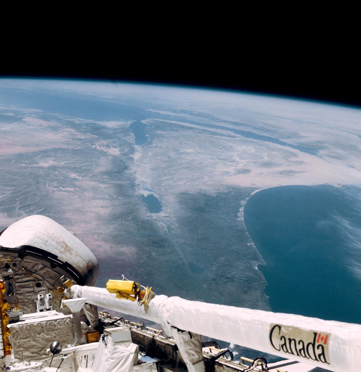
This southerly looking view photographed from the orbiting Space Shuttle Columbia shows a small portion of the vehichle's aft section. The 50-ft Canadian built remote manipulator system (RMS) is in a resting posture (lower right corner) stretched out along the 60-ft. long cargo bay. Many of the components of the OSS-1 payload package are in the bottom center. The Mediterranean Sea is at right foreground. Parts of the Sinai peninsula, Israel, Egypt, Saudi Arabia, Jordan, Palestine, Syria, and Lebanon can be located in the photo. The Red Sea, Gulf of Aqaba, Suez Canal are near the photo's horizon.
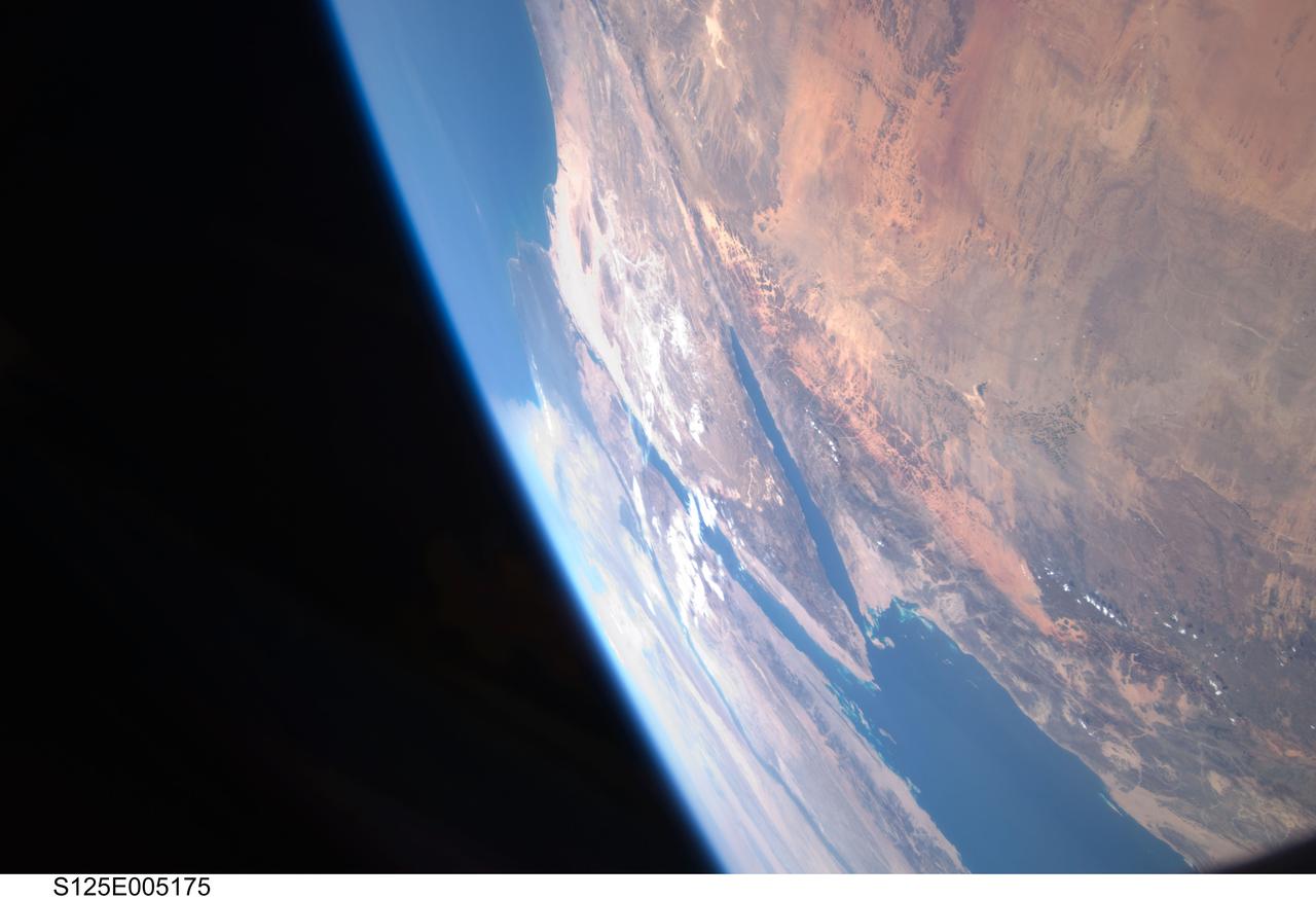
S125-E-005175 (12 May 2009) --- Among the first group of still images downlinked by the STS-125 crewmembers onboard the Space Shuttle Atlantis was this high oblique scene looking toward the Red Sea, Sinai Peninsula and the Mediterranean Sea. Saudi Arabia is in the foreground and Egypt?s Nile River and its delta can be seen (left) toward the horizon. Israel and Jordan can be seen near the top edge of the frame. The Gulf of Suez and the Gulf of Aqaba (near frame center) extend from the Red Sea toward the Mediterranean Sea.
S125-E-005173 (12 May 2009) --- Among the first group of still images downlinked by the STS-125 crewmembers onboard the Space Shuttle Atlantis was this high oblique scene looking toward the Sinai Peninsula and the Mediterranean Sea. The Red Sea is just out of frame at bottom right. Saudi Arabia is in the right foreground and Egypt?s Nile River and its delta can be seen (lower left) toward the horizon. Jordan and a small portion of Israel can be seen near the top of the frame. The Gulf of Suez and the Gulf of Aqaba extend from the Red Sea toward the Mediterranean.
ISS033-E-014856 (13 Oct. 2012) --- A nighttime view of Qatar is featured in this image photographed by an Expedition 33 crew member on the International Space Station. Night lights can be very revealing regarding the distribution of people on the landscape. Here the lights of Qatar show the precise demographic geography of the country. The brightest group at center shows the capital city Doha with the neighboring smaller ports of Ad-Dahira and Umm Sa?id to the north and south, respectively. Even highways and their relative importance can be discerned. Highways are clearly visible leading from the capital west to the Dukhan oil fields, to Saudi Arabia, and to the north of the country--where, judging by the lack of night lights, the population is very low. The relatively low-traffic coast road between the oil fields and the Saudi frontier also stands out. This kind of highly informative human geographic detail is very difficult to discern in daylight images, in which even larger cities, especially in deserts, are hard to see. Almost the entire island nation of Bahrain appears at lower left, with its capital city Manama nearly as bright as the lights of Doha. The difference in light intensity reflects a difference in population?Doha has 1.45 million inhabitants, while the very dense Manama metro area has a population of 1.2 million. While some night views are highly informative about a landscape, they can also be difficult and confusing to identify. Astronauts learn to recognize where they are at night by flying over populated places repeatedly, even though coastlines?one of their best geographic indicators?are generally lost to view because water surfaces and unpopulated land surfaces look the same without illumination (such as from a full moon). Thus the thumb-shaped Qatari peninsula, so well-known in Middle Eastern geography, cannot be discerned at all in this night image. The inset at top right overlays the coastline as seen in daylight onto the night patterns of the image. It shows the Qatari peninsula, with the long arm of the Gulf of Bahrain separating it from Saudi Arabia.
An excellent panoramic view of the entire Sinai Peninsula (29.0N, 34.0E) and the nearby Nile River Delta and eastern Mediterranean coastal region. The Suez Canal, at the top of the scene just to the right of the Delta, connects the Mediterranean Sea with the Gulf of Suez on the west side of the Sinai Peninsula and the Gulf of Aqaba is on the west where they both flow into the Red Sea. At upper right, is the Dead Sea, Jordan River and Lake Tiberius.
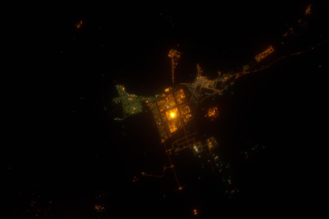
ISS031-E-143143 (19 June 2012) --- Al Jubayl, Saudi Arabia at night is featured in this image photographed by an Expedition 31 crew member on the International Space Station. The city of Al Jubayl (or Jubail) is located on the Saudi Arabian coastline of the Persian Gulf. The city has a history extending back more than 7,000 years, but since 1975 it has been associated with the heavy industries of petrochemical refining and production, fertilizer production and steel works. At night, these industrial areas form a brightly lit region (center) to the south of the residential and commercial center of Al Jubayl (characterized by green-gray lighting). An artificial peninsula extending into the Persian Gulf to the northeast hosts supertanker docks and petroleum storage facilities. The Persian Gulf to the north and northeast is devoid of lights; likewise, the open desert to the south-southeast provides a stark contrast to the well-lit urban and industrial areas. A bright circle of light located within the heavy industrial area (center) cannot be resolved in this photograph, but is likely a concentration of lights associated with ongoing processing or construction activities. The approximate scale of the feature ? hundreds of meters in diameter ? is consistent with multiple stationary light sources, particularly if the light from those sources is accentuated due to the camera?s low light settings.
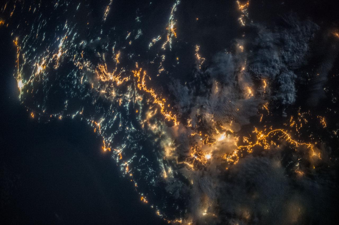
ISS036-E-025802 (26 July 2013) --- A nighttime view of southwestern Saudi Arabia is featured in this image photographed by an Expedition 36 crew member on the International Space Station. In addition to city lights, patchy cloud cover partially obscures and blurs city lights, especially in the vicinity of Khamis Mushait and Abha. While much of the country is lightly populated desert ? and relatively dark at night due to lack of city and roadway lights ? the southwestern coastal region has more moderate climate and several large cities. Three brightly lit urban centers are visible at top left; Jeddah, Mecca, and Taif. Jeddah is the gateway city for Islamic pilgrims going to nearby Mecca (a religious journey known as the hajj). Taif to the east is located on the slopes of the Sarawat Mountains, and provides a summer retreat for the Saudi government from the desert heat of the capital city of Riyadh. Bright yellow-orange lighting marks highways that parallel the trend of the Asir Mountains at center, connecting Mecca to the resort cities of Al Bahah and Abha (lower right). Smaller roadways, lit with blue lights, extend to the west to small cities along the Red Sea coastline. The bright yellow-orange glow of the city of Abha is matched by that of the city of Khamis Mushait (or Khamis Mushayt) to the northeast. The brightly lit ribbon of highway continues onward towards other large cities to the south (Jazan, not shown) and southeast (Najran, not shown).
Empty Quarter - February 1st, 20003 Description: White pinpricks of cloud cast ebony shadows on the Rub' al Khali, or Empty Quarter, near the border between Saudi Arabia and Yemen. The lines of wind-sculpted sand are characteristic of immense sand deserts, or sand seas, and the Rub' al Khali is the largest desert of this type in the world. A highland ridge is just high enough to disturb the flow of the lines. In the center of that interruption lies the Saudi Arabian town of Sharurah. Credit: USGS/NASA/Landsat 7 To learn more about the Landsat satellite go to: <a href="http://landsat.gsfc.nasa.gov/" rel="nofollow">landsat.gsfc.nasa.gov/</a> <b><a href="http://www.nasa.gov/centers/goddard/home/index.html" rel="nofollow">NASA Goddard Space Flight Center</a></b> enables NASA’s mission through four scientific endeavors: Earth Science, Heliophysics, Solar System Exploration, and Astrophysics. Goddard plays a leading role in NASA’s accomplishments by contributing compelling scientific knowledge to advance the Agency’s mission. <b>Follow us on <a href="http://twitter.com/NASA_GoddardPix" rel="nofollow">Twitter</a></b> <b>Join us on <a href="http://www.facebook.com/pages/Greenbelt-MD/NASA-Goddard/395013845897?ref=tsd" rel="nofollow">Facebook</a></b>
STS079-824-081 (16-26 Sept. 1996) --- In this 70mm frame from the space shuttle Atlantis, the Jordan River Valley can be traced as it separates Lebanon, Palestine and Israel on the west, from Syria and Jordan on the east. The river flows along the Dead Sea rift; the east side of the fault zone (Syria, Jordan, Saudi Arabia) has moved north about 100 kilometers relative to the west side (Lebanon, Israel, Egypt) during the past 24 million years. The Dead Sea and Sea of Galilee are in depressions formed where faults of the zone diverge or step over. The Dead Sea once covered the area of salt evaporation pans (the bright blue water). The lagoon, barrier islands and evaporite deposits (bright white) along the Mediterranean coast of the Sinai Peninsula (lower left of frame) are just east of Port Said.
STS077-711-039 (21 May 1996) --- The Spartan 207 free flyer is held in a hover mode above its berth (out of frame) in the Space Shuttle Endeavour?s cargo bay in the grasp of the Remote Manipulator System (RMS). The satellite is backdropped over the coast of Saudi Arabia, about 200 miles south of Jiddah near Al Qunfudhah. The free-flyer was re-captured by the six crew members on May 21, 1996. The Endeavour crew spent a portion of the flight time in various activities involving the Spartan 207 and the related Inflatable Antenna Experiment (IAE). The Spartan project is managed by NASA?s Goddard Space Flight Center for NASA?s Office of Space Science, Washington, D.C.
S66-54893 (14 Sept. 1966) --- Near East area as seen from the orbiting Gemini-11 spacecraft during its 26th revolution of Earth. The United Arab Republic (Egypt) is in foreground. Triangular-shaped area is the Sinai Peninsula. Saudi Arabia is at upper right. The Mediterranean Sea is at upper left. The Gulf of Suez separates Egypt from the Sinai Peninsula. The Red Sea is at bottom right. The Gulf of Aqaba is the body of water in right center of photograph separating the Sinai Peninsula and the Arabian Peninsula. The Dead Sea, Sea of Galilee, Jordan and Israel are in top center of picture. Iraq is at top right edge of photograph. Taken with a J. A. Maurer 70mm camera, using Eastman Kodak, Ektachrome, MS (S.O. 368) color film. Photo credit: NASA
STS080-745-004 (19 Nov.-7 Dec. 1996) --- A view to the west showing Asia in the foreground and Africa in the background, as photographed by the space shuttle Columbia crewmembers. The Mediterranean Sea is to the upper right and the Red Sea to the lower left (holding photograph with NASA numbers on left). Sinai Peninsula is between the two with the Gulf of Suez above and the Gulf of Aqaba below. The Suez Canal connects the Gulf of Suez with the Mediterranean Sea. The triangular shaped dark area beyond is the Nile River Delta. The thin green fertile valley of the Nile crosses the photograph from a point at Cairo (near dark triangle area) past the great bend at Luxor with Thebes and the Valley of the Kings, and on the left into the Nubian Desert with the Aswan High Dam at the very left edge of the photograph. To the horizon is the Western Desert of Egypt and Libya. The foreground is the northwest portion of Saudi Arabia, an area known as the Hejaz with the southern portions of Israel and Jordan to the lower right.
AS10-34-5026 (18-26 May 1969) --- An Apollo 10 photograph of Earth taken from 100,000 miles away. Visible are many areas of Europe and Africa. Among the features and countries identifiable are Portugal, Spain, Italy, the Mediterranean Sea, Greece, Turkey, Bulgaria, the Black Sea, Libya, Egypt, Saudi Arabia, the Sinai Peninsula, the Nile Delta, Lake Chad, and South Africa. The crew members for Apollo 10 are astronauts Thomas P. Stafford, commander; John W. Young, command module pilot; and Eugene E. Cernan, lunar module pilot. Astronaut Young remained in lunar orbit, in the Command and Service Modules (CSM) "Charlie Brown", while astronauts Stafford and Cernan descended to within nine miles of the lunar surface, in the Lunar Module (LM) "Snoopy".

STS083-709-030 (4-8 April 1997) --- Panorama over the Nile River, Sinai Peninsula and the Red Sea. Looking past the Orbiter's tail, this view extends from central Egypt eastward to Saudi Arabia on the horizon. Two major water systems, seen in this view, the Nile River and the Red Sea are used for world commerce and transportation in this region. The Nile is flanked immediately by agriculture then beyond by desert. This emphasizes the importance of the river waters to sustain a thriving local population. The Nile River delta is north under the clouds on the upper left-hand corner of the photo. Geologically, the Red Sea is a spreading center between the Arabian and the African Plates, and will continue to widen slowly over a long period of time.
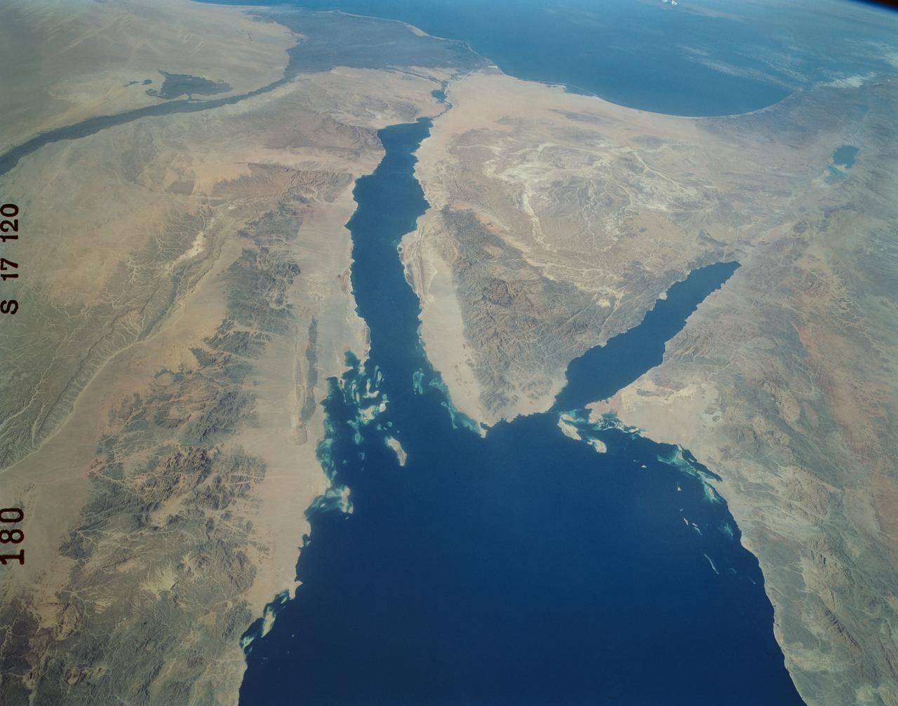
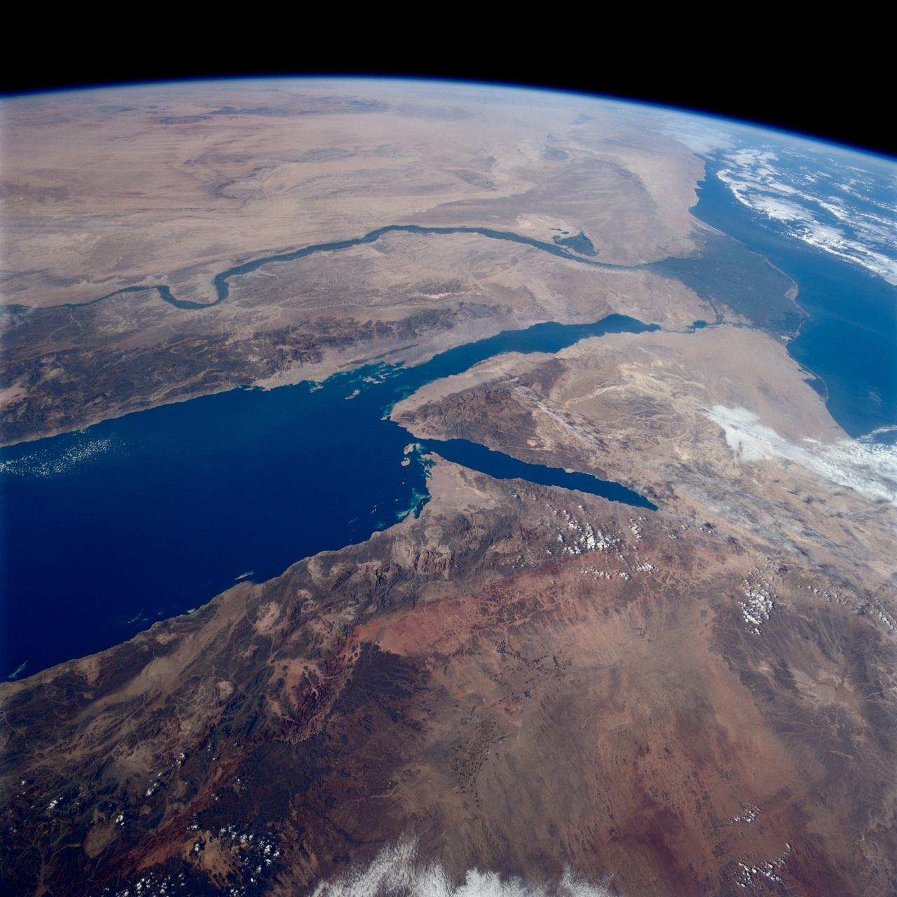
ISS036-E-010628 (24 June 2013) --- Strait of Tiran, Red Sea and Gulf of Aqaba are featured in this image photographed by an Expedition 36 crew member on the International Space Station. The approximately six-kilometer wide Strait of Tiran (also known as the Straits of Tiran) between the Egyptian mainland and Tiran Island separates the Gulf of Aqaba from the Red Sea, and provides two channels (290 meters and 73 meters deep, respectively) navigable by large ships bound for ports in Jordan and Israel. A smaller passage also exists between the east side of Tiran Island and Saudi Arabia, but this a single channel that is 16 meters deep. Due to its strategic position, control of the Strait has been an important factor in historical conflicts of the region, such as the Suez Crisis in 1956 and the Six-Day War in 1967. This photograph illustrates the morphology of the Strait. The relatively clear, deep-water passages of the western Strait of Tiran are visible at right, while the more sinuous shallow-water passage on the Saudi Arabia side can be seen at bottom center. Light blue to turquoise areas around Tiran Island indicate shallow water, while the island itself is arid and largely free of vegetation. Coral reefs are also found in the Straits of Tiran and are a popular diving destination. The silvery sheen on the water surface within the Strait and the south of Tiran Island is sunglint – light reflecting off the water surface back towards the observer on the space station. Disturbance to the water surface, as well as presence of substances such as oils and surfactants, can change the reflective properties of the water surface and highlight both surface waves and subsurface currents. For example, a large wave set is highlighted by sunglint at upper left.
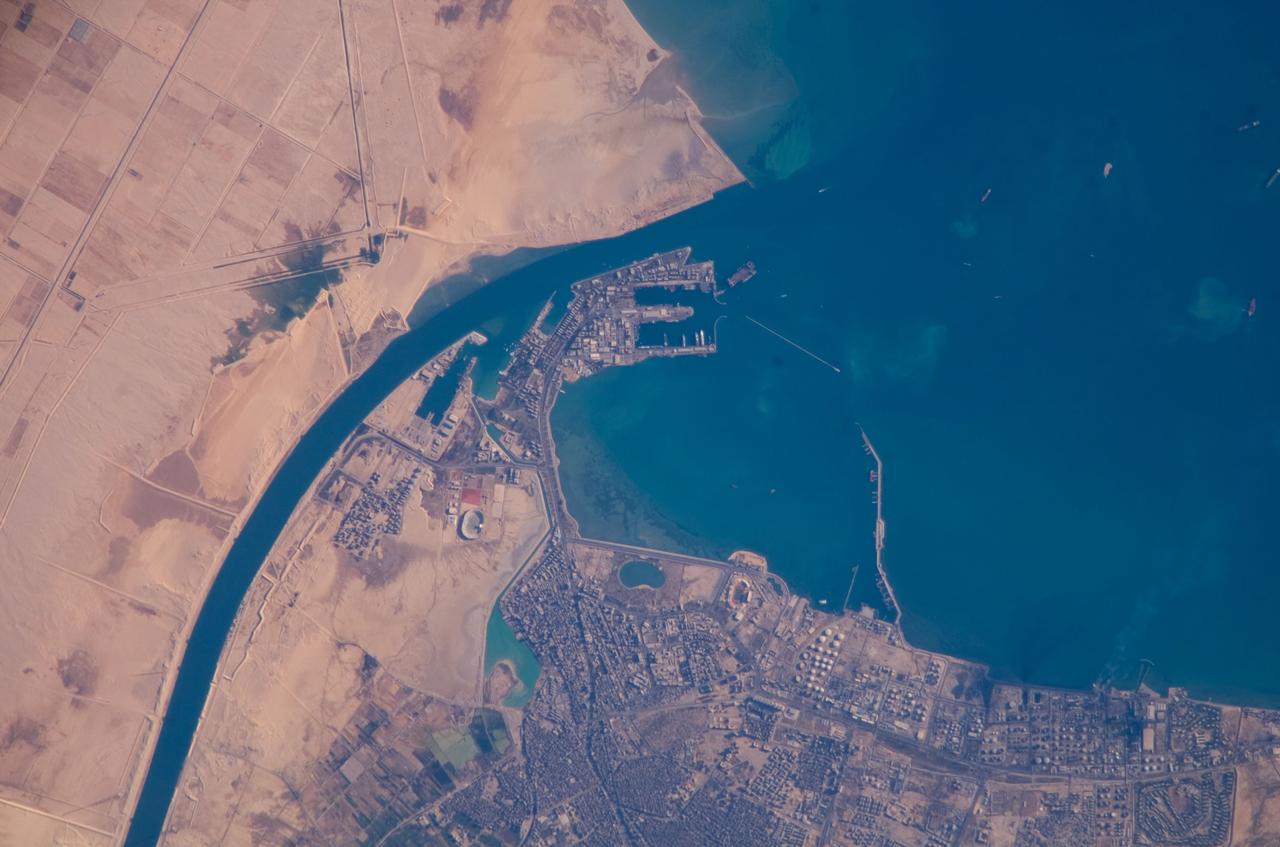
ISS016-E-019375 (30 Dec. 2007) --- Port of Suez, Egypt is featured in this image photographed by an Expedition 16 crewmember on the International Space Station. The Port of Suez is located in Egypt along the northern coastline of the Gulf of Suez. The port and city are the southern terminus of the Suez Canal that transits through Egypt and debouches into the Mediterranean Sea near Port Said. The port serves vessels transporting general cargo, oil tankers, and both commercial and private passenger vessels. The port is also an important waypoint for Muslim pilgrims traveling to and from Mecca in Saudi Arabia. Several large vessels are visible in the Gulf of Suez and berthed at various docks around the port. An extensive petroleum refinery complex forms the southern coastal boundary of the Port of Suez. At the time this image was acquired, gaseous byproducts of petroleum processing were being burned off -- as indicated by a smoke plume extending southwards into the Gulf of Suez (lower right). This view also captures several regions of greenish blue coloration in the Gulf. These are most probably sediments stirred up by passage of ships traveling to and from the Port. Similarly-colored regions along the coastline are bottom sediments visible through the shallow water column.
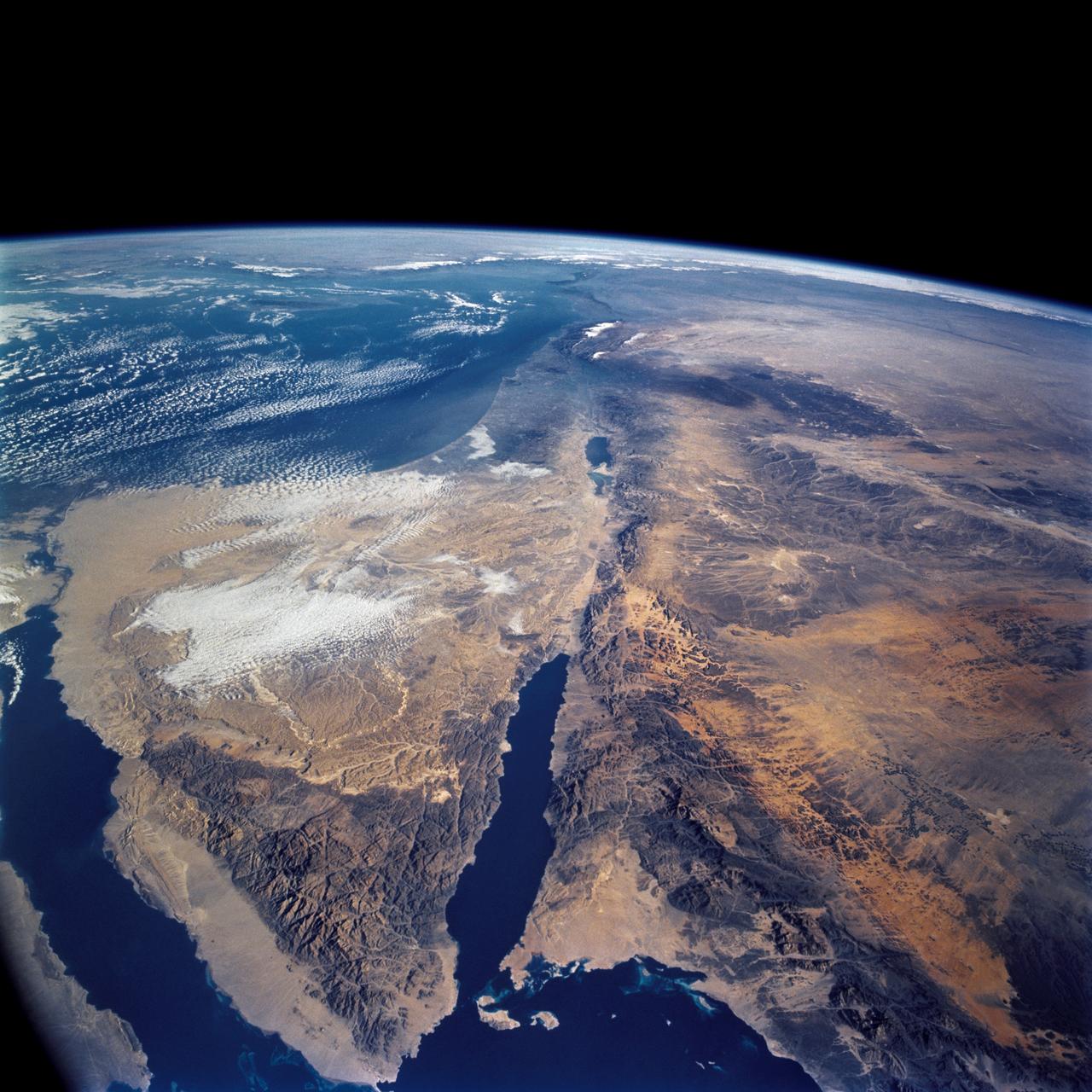
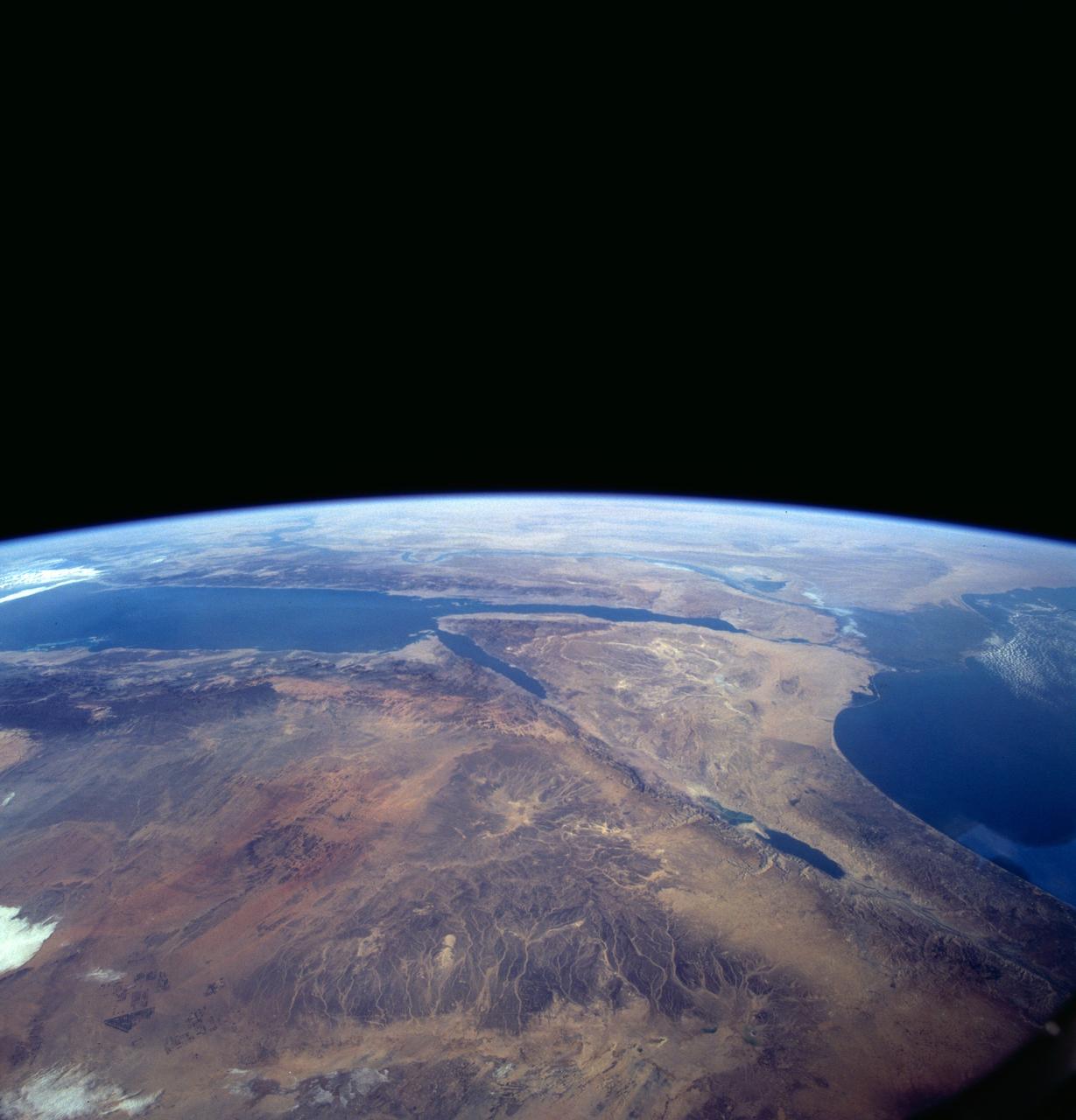
STS109-708-024 (1-12 March 2002) --- The astronauts on board the Space Shuttle Columbia took this 70mm picture featuring the Sinai Peninsula and the Dead Sea Rift. The left side of the view is dominated by the great triangle of the Sinai peninsula, which is partly obscured by an unusual cloud mass on this day. The famous Monastery of St. Catherine lies in the very remote, rugged mountains in the southern third of the peninsula (foreground). The Gulf of Aqaba is a finger of the Red Sea bottom center, pointing north to the Dead Sea, the small body of water near the center of the view. According to NASA scientists studying the STS-109 photo collection, the gulf and the Dead Sea are northerly extensions of the same geological rift that resulted in the opening of the Red Sea . The Gulf of Suez appears in the lower left corner. Northwest Saudi Arabia occupies the lower right side of the view, Jordan and Syria the right and top right, and the Eastern Mediterranean Sea the top left. Thin white lines of cloud have formed along the coastal mountains of southern Turkey and stretch across the top of the view near the Earth's limb.
STS062-151-182Z (4-18 March 1994) --- This east-looking view shows most of the east-west extent of the country of Sudan. The foreground shows a vegetation-less and almost uninhabited region of northwest Sudan. The rich earth colors are ancient soils (browner and redder tones), a concentrated mass of what may be volcanic cinder cones (dark brown dots - center) and dune and younger river sediments (yellows). The photo would have been difficult to locate had it not been for two recognizable features in the background: a visually well-known inselberg ("island mountain" -- top center) on a large west-bank tributary of the White Nile; and the confluence of the Blue and White Nile's, with the great cotton developments of the Gezira Scheme between them (top left). The Red Sea coast is almost obscured by a dust cloud but can be discerned running across the top of the picture. The clouds at top may be developing over the coastal ranges of Saudi Arabia beyond the Red Sea.

Nils Larson is a research pilot in the Flight Crew Branch of NASA's Dryden Flight Research Center, Edwards, Calif. Larson joined NASA in February 2007 and will fly the F-15, F-18, T-38 and ER-2. Prior to joining NASA, Larson was on active duty with the U.S. Air Force. He has accumulated more that 4,900 hours of military and civilian flight experience in more than 70 fixed and rotary winged aircraft. Larson completed undergraduate pilot training at Williams Air Force Base, Chandler, Ariz., in 1987. He remained at Williams as a T-37 instructor pilot. In 1991, Larson was assigned to Beale Air Force Base, Calif., as a U-2 pilot. He flew 88 operational missions from Korea, Saudi Arabia, the United Kingdom, Panama and other locations. Larson graduated from the U.S. Air Force Test Pilot School at Edwards Air Force Base, Calif., in Class 95A. He became a flight commander and assistant operations officer for the 445th squadron at Edwards. He flew the radar, avionics integration and engine tests in F-15 A-D, the early flights of the glass cockpit T-38C and airworthiness flights of the Coast Guard RU-38. He was selected to serve as an Air Force exchange instructor at the U.S. Naval Test Pilot School, Patuxent River, Md. He taught systems and fixed-wing flight test and flew as an instructor pilot in the F-18, T-2, U-6A Beaver and X-26 Schweizer sailplane. Larson commanded U-2 operations for Warner Robins Air Logistics Center's Detachment 2 located in Palmdale, Calif. In addition to flying the U-2, Larson supervised the aircraft's depot maintenance and flight test. He was the deputy group commander for the 412th Operations Group at Edwards before retiring from active duty in 2007 with the rank of lieutenant colonel. His first experience with NASA was at the Glenn Research Center, Cleveland, where he served a college summer internship working on arcjet engines. Larson is a native of Bethany, W.Va,, and received his commission from the U.S. Air Force Academy in 1986 with a

ISS036-E-011050 (22 June 2013) --- An Egyptian dust plume and the Red Sea are featured in this image photographed by an Expedition 36 crew member on the International Space Station. This photograph provides a panoramic view of most of the length of the Red Sea, with the northernmost end, the Gulf of Suez, just visible at top center—fully 1,900 kilometers (ground distance) from the space station. The River Nile snakes its way northward through the Sahara Desert at top left. Much closer to the camera—but still more than 550 kilometers distant from the ground point above which the space station is orbiting—is a prominent dust plume surging out over the clear water of the Red Sea (foreground), reaching most of the way to Saudi Arabia. The “point source” of this plume is the delta of the southern Egyptian river Khor Baraka. Images from the spacecraft have shown that this delta is a common source for dust plumes, mainly because it is a relatively large area of exposed, loose sand and clay, easily lofted into the air. But the river also cuts through a high range of hills in a narrow valley that channels the wind, making it blow faster. This dramatic view of the Red Sea shows the generally parallel margins of the opposing coastlines. According to scientists, the rift or depression which now holds the Red Sea has been opening slowly for about 30 million years, and is nearly 300 kilometers wide in the region of the dust plume. Scientists believe the depression only recently filled with seawater within the last approximately five million years.
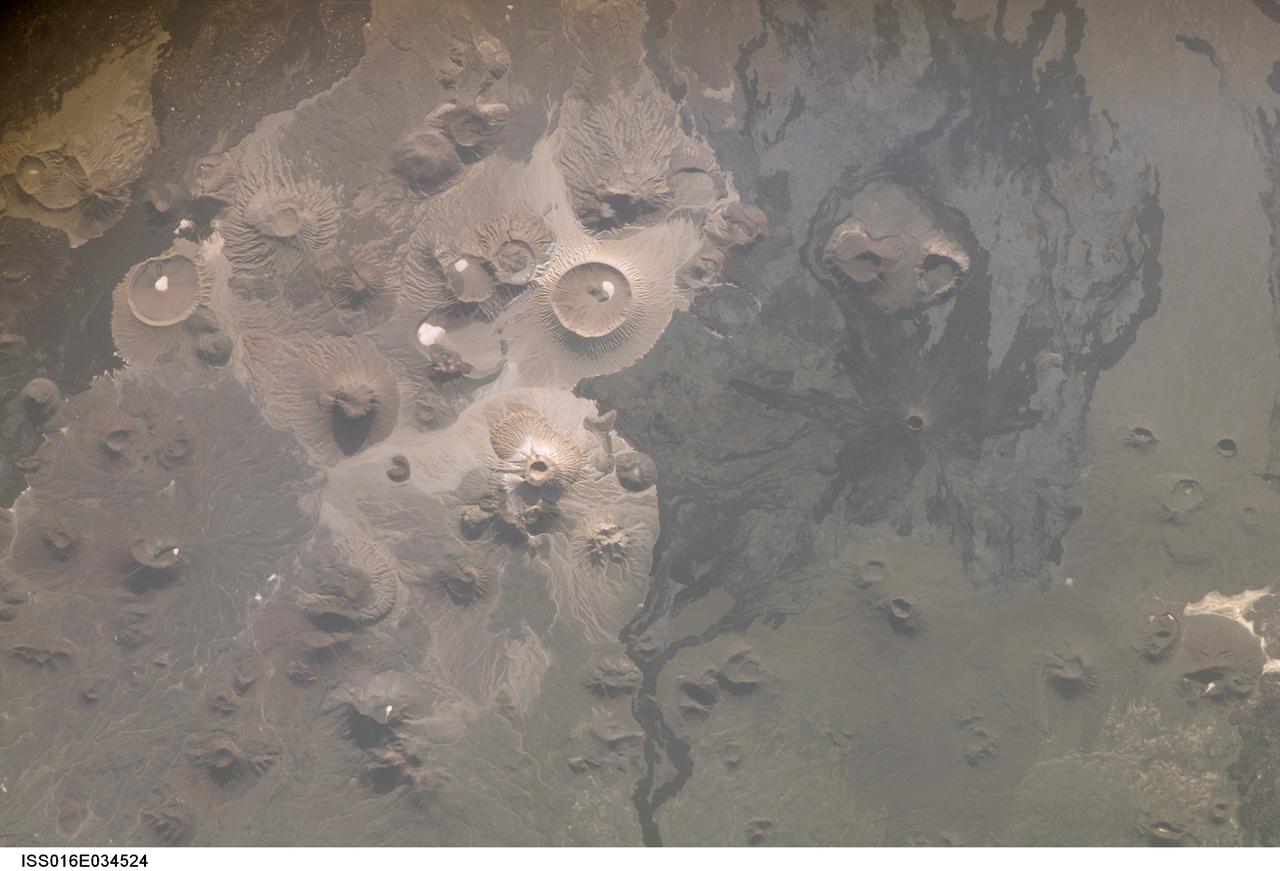
ISS016-E-034524 (31 March 2008) --- Harrat Khaybar, Saudi Arabia is featured in this image photographed by an Expedition 16 crewmember on the International Space Station. The western half of the Arabian peninsula contains not only large expanses of sand and gravel, but extensive lava fields known as haraat (harrat for a named field). One such field is the 14,000-square kilometer Harrat Khaybar, located approximately 137 kilometers to the northeast of the city of Al Madinah (Medina). According to scientists, the volcanic field was formed by eruptions along a 100-kilometer long north-south linear vent system over the past 5 million years; the most recent recorded eruption took place between 600 - 700 A.D. Harrat Khaybar contains a wide range of volcanic rock types and spectacular landforms, several of which are represented in this view. Jabal al Quidr is built from several generations of dark, fluid basalt lava flows; the flows surround the 322--meter high stratovolcano (Jabal is translated as "mountain" in Arabic). Jabal Abyad, in the center of the image, was formed from a more viscous, silica-rich lava classified as a rhyolite. While Jabal al Quidr exhibits the textbook cone shape of a stratovolcano, Jabal Abyad is a lava dome -- a rounded mass of thicker, more solidified lava flows. To the west (top center) is the impressive Jabal Bayda'. This symmetric structure is a tuff cone, formed by eruption of lava in the presence of water. This leads to the production of wet, sticky pyroclastic deposits that can build a steep cone structure, particularly if the deposits consolidate quickly. White deposits visible in the crater of Jabal Bayda' (and two other locations to the south) are formed from sand and silt that accumulate in shallow, protected depressions. The presence of tuff cones -- together with other volcanic features indicative of water -- in the Harrat Khaybar suggest that the local climate was much wetter during some periods of volcanic activity. Today, however, the regional climate is hyperarid -- little to no yearly precipitation -- leading to an almost total lack of vegetation.
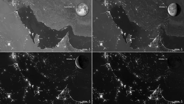
NASA images acquired October 15, 2012 The Visible Infrared Imaging Radiometer Suite (VIIRS) on the Suomi NPP satellite captured these nighttime views of the Persian Gulf region on September 30, October 5, October 10, and October 15, 2012. The images are from the VIIRS “day-night band,” which detects light in a range of wavelengths from green to near-infrared and uses filtering techniques to observe signals such as gas flares, auroras, wildfires, city lights, and reflected moonlight. Each image includes an inset of the Moon in four different phases. September 30 shows the Persian Gulf by the light of the full Moon; October 15 shows the effects of a new Moon. As the amount of moonlight decreases, some land surface features become harder to detect, but the lights from cities and ships become more obvious. Urbanization is most apparent along the northeastern coast of Saudi Arabia, in Qatar, and in the United Arab Emirates (UAE). In Qatar and UAE, major highways can even be discerned by nighttime lights. In eighteenth-century England, a small group of entrepreneurs, inventors and free thinkers—James Watt and Charles Darwin’s grandfathers among them—started a club. They named it the Lunar Society, and the “lunaticks” scheduled their dinner meetings on evenings of the full Moon. The timing wasn’t based on any kind of superstition, it was based on practicality. In the days before electricity, seeing one’s way home after dark was far easier by the light of a full Moon. In the early twenty-first century, electricity has banished the need for such careful scheduling, but the light of the full Moon still makes a difference. NASA Earth Observatory image by Jesse Allen and Robert Simmon, using VIIRS day-night band data from the Suomi National Polar-orbiting Partnership. Suomi NPP is the result of a partnership between NASA, the National Oceanic and Atmospheric Administration, and the Department of Defense. Caption by Michon Scott. Instrument: Suomi NPP - VIIRS Credit: <b><a href="http://www.earthobservatory.nasa.gov/" rel="nofollow"> NASA Earth Observatory</a></b> <b>Click here to view all of the <a href="http://earthobservatory.nasa.gov/Features/NightLights/" rel="nofollow"> Earth at Night 2012 images </a></b> <b>Click here to <a href="http://earthobservatory.nasa.gov/NaturalHazards/view.php?id=79834" rel="nofollow"> read more </a> about this image </b> <b><a href="http://www.nasa.gov/audience/formedia/features/MP_Photo_Guidelines.html" rel="nofollow">NASA image use policy.</a></b> <b><a href="http://www.nasa.gov/centers/goddard/home/index.html" rel="nofollow">NASA Goddard Space Flight Center</a></b> enables NASA’s mission through four scientific endeavors: Earth Science, Heliophysics, Solar System Exploration, and Astrophysics. Goddard plays a leading role in NASA’s accomplishments by contributing compelling scientific knowledge to advance the Agency’s mission. <b>Follow us on <a href="http://twitter.com/NASA_GoddardPix" rel="nofollow">Twitter</a></b> <b>Like us on <a href="http://www.facebook.com/pages/Greenbelt-MD/NASA-Goddard/395013845897?ref=tsd" rel="nofollow">Facebook</a></b> <b>Find us on <a href="http://instagram.com/nasagoddard?vm=grid" rel="nofollow">Instagram</a></b>