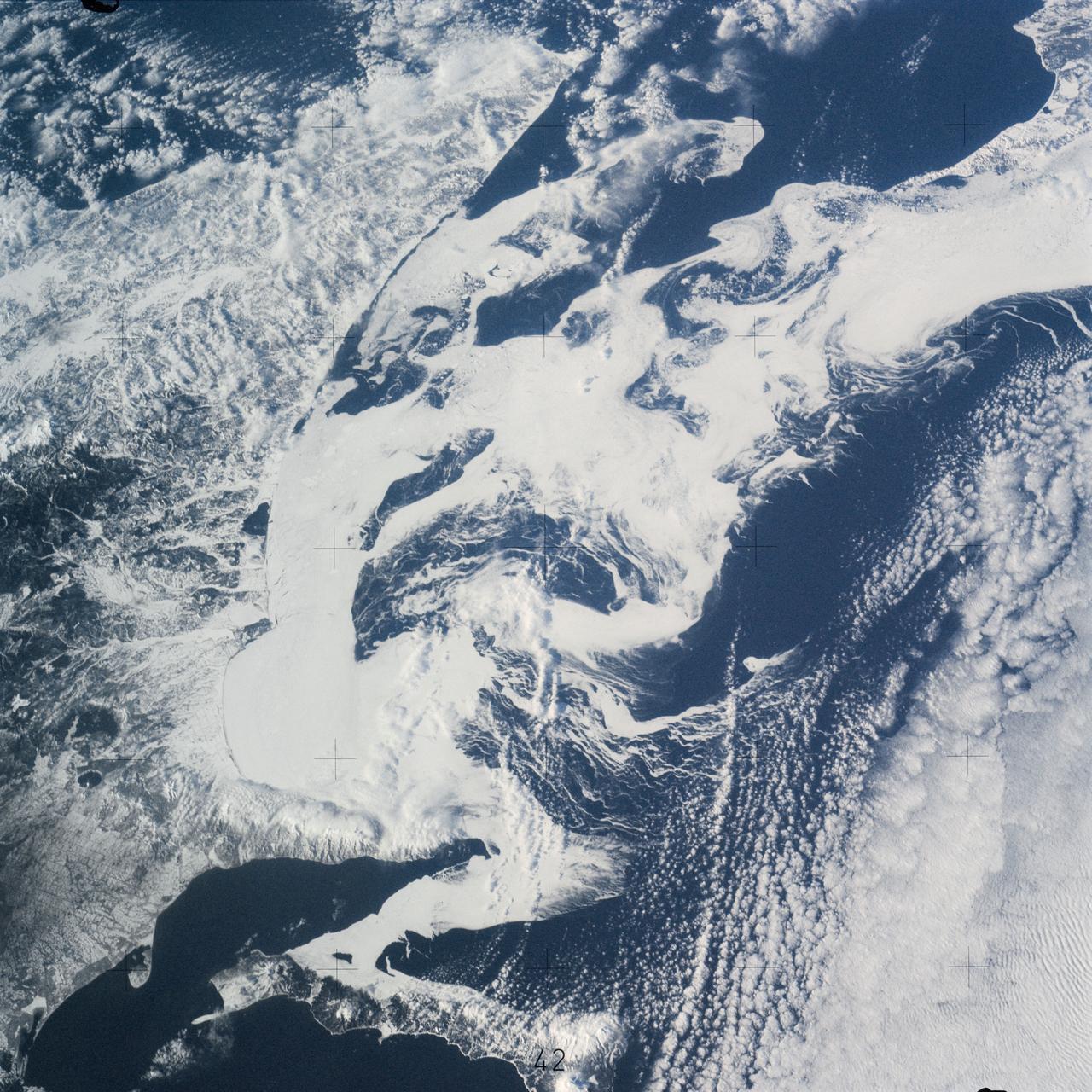
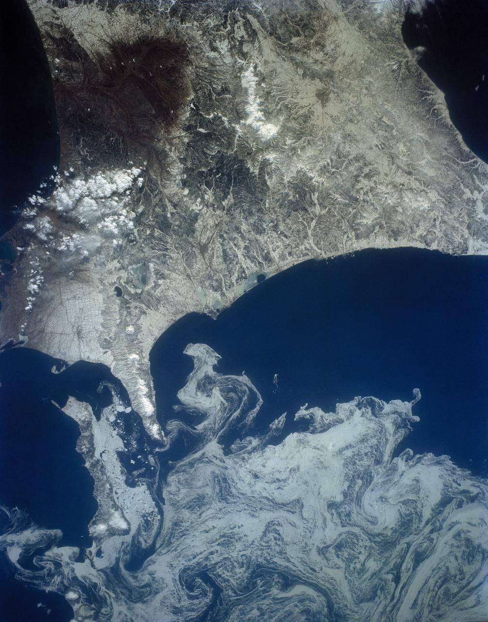
SL4-141-4340 (20 Jan. 1974) --- An oblique view of the southern part of the Sea of Okhotsk, north of Japan, as photographed from the Skylab space station in Earth orbit by one of the Skylab 4 crewmen. The camera used was a hand-held 70mm Hasselblad, and SO-368 medium-speed Ektachrome. NORTH IS AT THE TOP WHEN THE PICTURE IS HELD WITH THE LARGEST LAND MASS AT THE BOTTOM. Most of the land area is Hokkaido Island, Japan. The southern tip of Sakhalin Island (Soviet Union) is in the northwest corner. This photograph was taken to aid in the study of the formation of sea ice. Comparison of these photographs will be made with observations made during a joint USSR-U.S. experiment in the Bering Sea a year earlier. Observations in the Sea of Okhotsk are of interest because the ice has a morphology similar to that of the Bering Sea. Photo credit: NASA
SL4-140-4110 (January 1974) --- View of the USSR, Siberia area from Skylab 4. Other areas seen are Ozero, Kanka, Ussiriysk, the Sea of Japan and Kavalerovo (45.5N, 135.5E). Photo credit: NASA
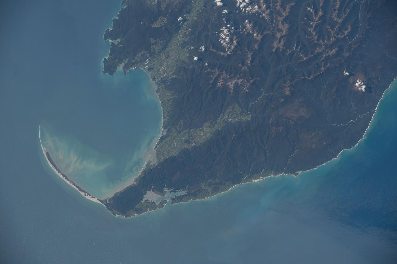
iss073e0379903 (July 20, 2025) --- Japan's Chūbu region coast on the Sea of Japan, with the city of Joetsu on the far left and the cities of Asahi, Nyuzen, and Kurobe on the far right, is pictured from the International Space Station as it orbited 260 miles above the Asian island nation.
iss073e0983131 (Sept. 21, 2025) --- A partly cloudy Korean Peninsula, surrounded by the sun's glint reflecting off the Sea of Japan and the Yellow Sea, is pictured from the International Space Station as it orbited 259 miles above Earth off the coast of western Japan.
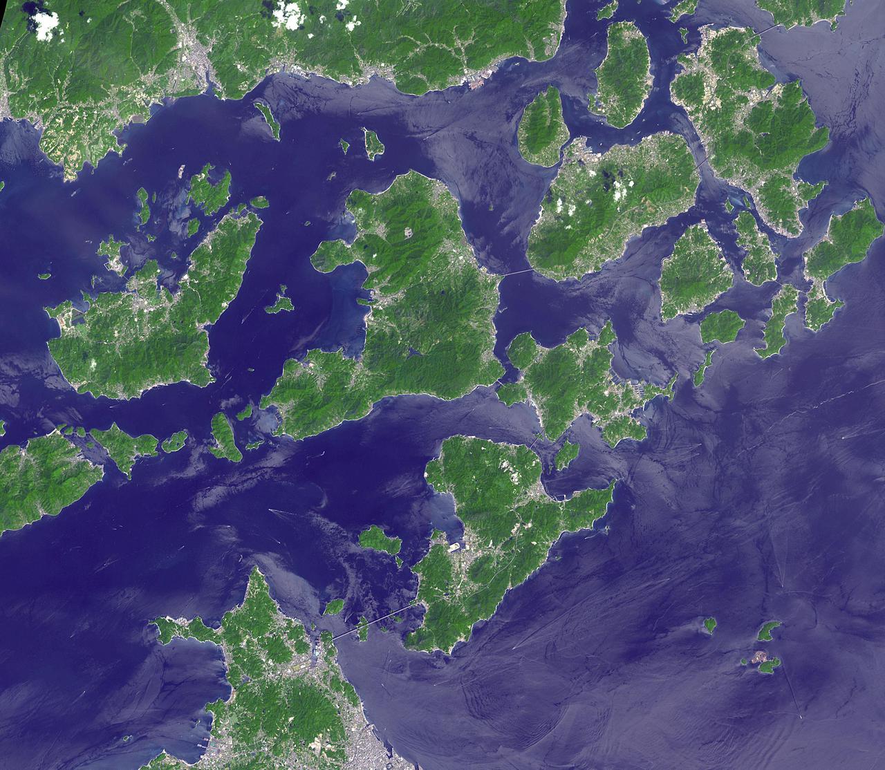
Japan's Geiyo Archipelago, in the Seito Inland Sea, was once home to pirates. From the 9th to the 16th centuries, the pirates dominated the Inland Sea and terrorized the coasts of East Asia. Until the Shimanami Kaido (Inland Wave Sea Road) was completed in 1999, the Geiyo Islands were a remote region, accessible only by boat. The ASTER image was acquired August 19, 2010, covers an area of 33.7 by 43.7 km, and is located at 34.3 degrees north, 133.1 degrees east. https://photojournal.jpl.nasa.gov/catalog/PIA25185
The northeast coast of Hokkaido and Kunashir Island, Japan (44.0N, 143.0E) are seen bordered by drifting sea ice. The sea ice has formed a complex pattern of eddies in response to surface water currents and winds. Photos of this kind aid researchers in describing local ocean current patterns and the effects of wind speed and direction on the drift of surface material, such as ice floes or oil. Kunashir is the southernmost of the Kuril Islands.
The north coast of the Island of Hokkaido, Japan lies at the southern end of the Sea of Okhotsk. NASA Terra spacecraft acquired this image on February 11, 2009.

The MODIS instrument on NASA's Aqua satellite captured Typhoon Neoguri in the East China Sea at 05:00 UTC (1:00 AM EDT) on July 8, 2014. Typhoon Neoguri hit Japan’s Okinawa islands on Tuesday local time (July 8, 2014), bringing high winds, huge waves and storm surges. Neoguri packed sustained winds of 175 kilometers (108 miles) per hour with some gusts up to 250 kph (154 mph), according to the Japan Meteorological Agency. Credit: NASA/GSFC/Jeff Schmaltz/MODIS Land Rapid Response <b><a href="http://www.nasa.gov/audience/formedia/features/MP_Photo_Guidelines.html" rel="nofollow">NASA image use policy.</a></b> <b><a href="http://www.nasa.gov/centers/goddard/home/index.html" rel="nofollow">NASA Goddard Space Flight Center</a></b> enables NASA’s mission through four scientific endeavors: Earth Science, Heliophysics, Solar System Exploration, and Astrophysics. Goddard plays a leading role in NASA’s accomplishments by contributing compelling scientific knowledge to advance the Agency’s mission. <b>Follow us on <a href="http://twitter.com/NASAGoddardPix" rel="nofollow">Twitter</a></b> <b>Like us on <a href="http://www.facebook.com/pages/Greenbelt-MD/NASA-Goddard/395013845897?ref=tsd" rel="nofollow">Facebook</a></b> <b>Find us on <a href="http://instagram.com/nasagoddard?vm=grid" rel="nofollow">Instagram</a></b>
iss061e120106 (Jan. 4, 2020) --- The lights of South Korean cities and fishing boats on the Sea of Japan and the Yellow Sea are pictured as the International Space Station orbited 260 miles in altitude off the coast of Japan near Hiroshima. The brightest city lights toward the center represent the South Korean capital city of Seoul.
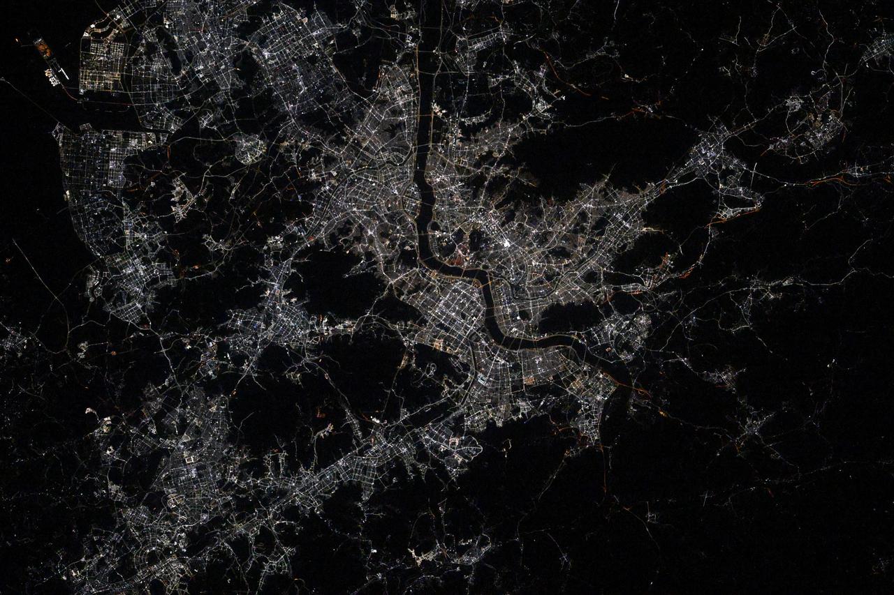
iss072e519516 (Jan. 22, 2025) --- The city lights of Osaka, Japan, the island nation's third most populous city split by the Yodo River, are pictured at approximately 10:25 p.m. local time from the International Space Station as it orbited 258 miles above the Philippine Sea.
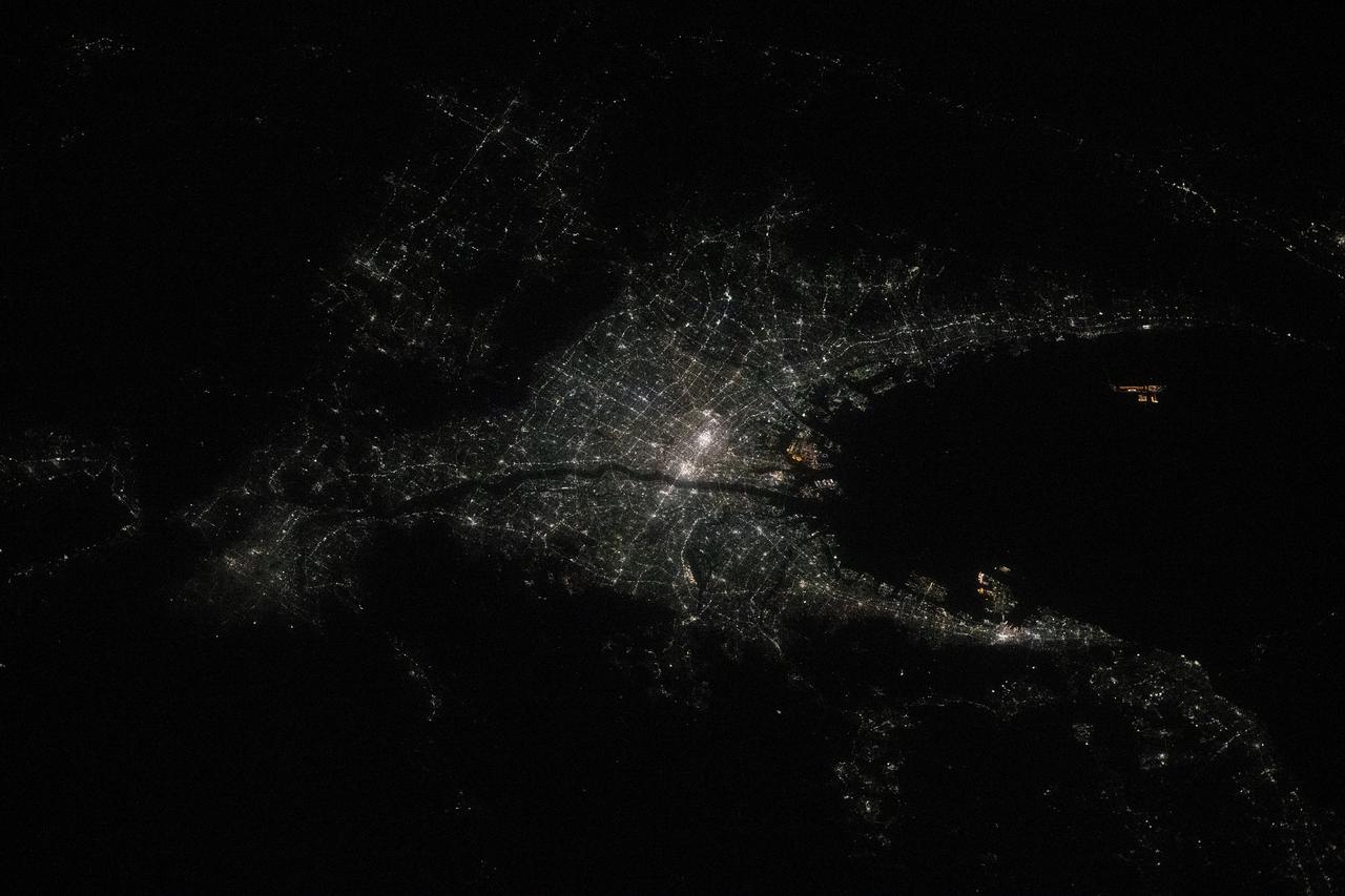
iss066e158964 (March 8, 2022) --- The city of Asahikawa, on Japan's northern island of Hokkaido, is pictured during an orbital night pass from the International Space Station at an altitude of 264 miles above the Sea of Japan.
iss066e158950 (March 8, 2022) --- Sapporo, the capital of Japan's northern island of Hokkaido, split by the Toyohira River, is pictured during an orbital night pass from the International Space Station at an altitude of 264 miles above the Sea of Japan.

iss055e006531 (March 30, 2018) --- The International Space Station was off the coast of northern Japan when an Expedition 55 crew member took this photograph. The sun's glint is reflected off the Sea of Japan and the North Pacific Ocean.

ISS049e008889 (09/23/2016) --- Night view of the Earth from the International Space Station by the crew of Expedition 49. The land mass northwest is South Korea and south of Korea is Japan. The small dotted lights east of South Korea and north of Japan are fishing boats in the Sea of Japan.

iss065e009306 (April 28, 2021) --- The International Space Station flies into an orbital sunrise 264 miles above far eastern China near the the Sea of Japan.
iss072e436230 (Dec. 28, 2024) --- The city lights of Osaka, Nagoya, and Tokyo on the island nation of Japan highlight this photograph taken approximately 12:55 a.m. local time from the International Space Station as it orbited 258 miles above the Sea of Japan.
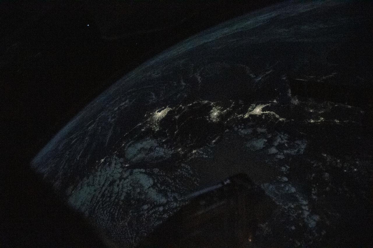
iss068e021122 (Nov. 8, 2022) --- The night lights of the Japanese cities of Tokyo, Nagoya, and Osaka, are pictured from the International Space Station as it orbited 258 miles above the Sea of Japan.
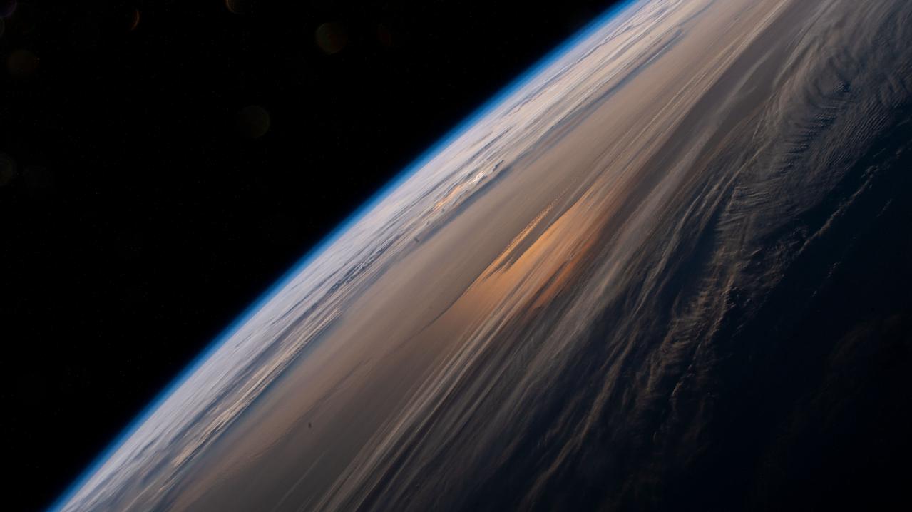
iss065e009308 (April 28, 2021) --- The early morning hues of an orbital sunrise are pictured from the International Space Station as it soared 264 miles above the China-Russia border in far eastern Asia near the the Sea of Japan.
iss064e037541 (Feb. 24, 2021) --- The city lights of Japan, blanketed by the air glow above Earth's horizon, are pictured from International Space Station as it orbited 260 miles above the Philippine Sea south of the island nation .
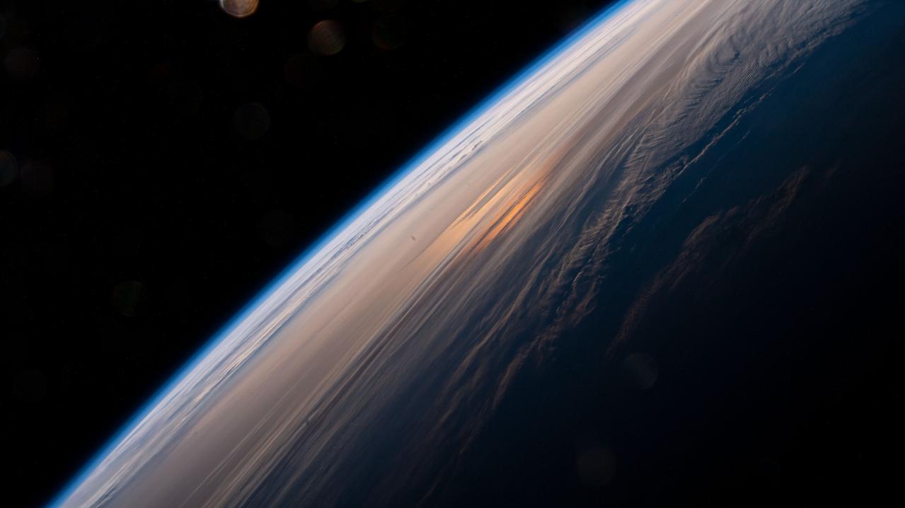
iss065e009307 (April 28, 2021) --- The early morning hues of an orbital sunrise are pictured from the International Space Station as it soared 264 miles above the China-Russia border in far eastern Asia near the the Sea of Japan.
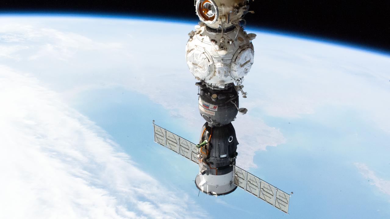
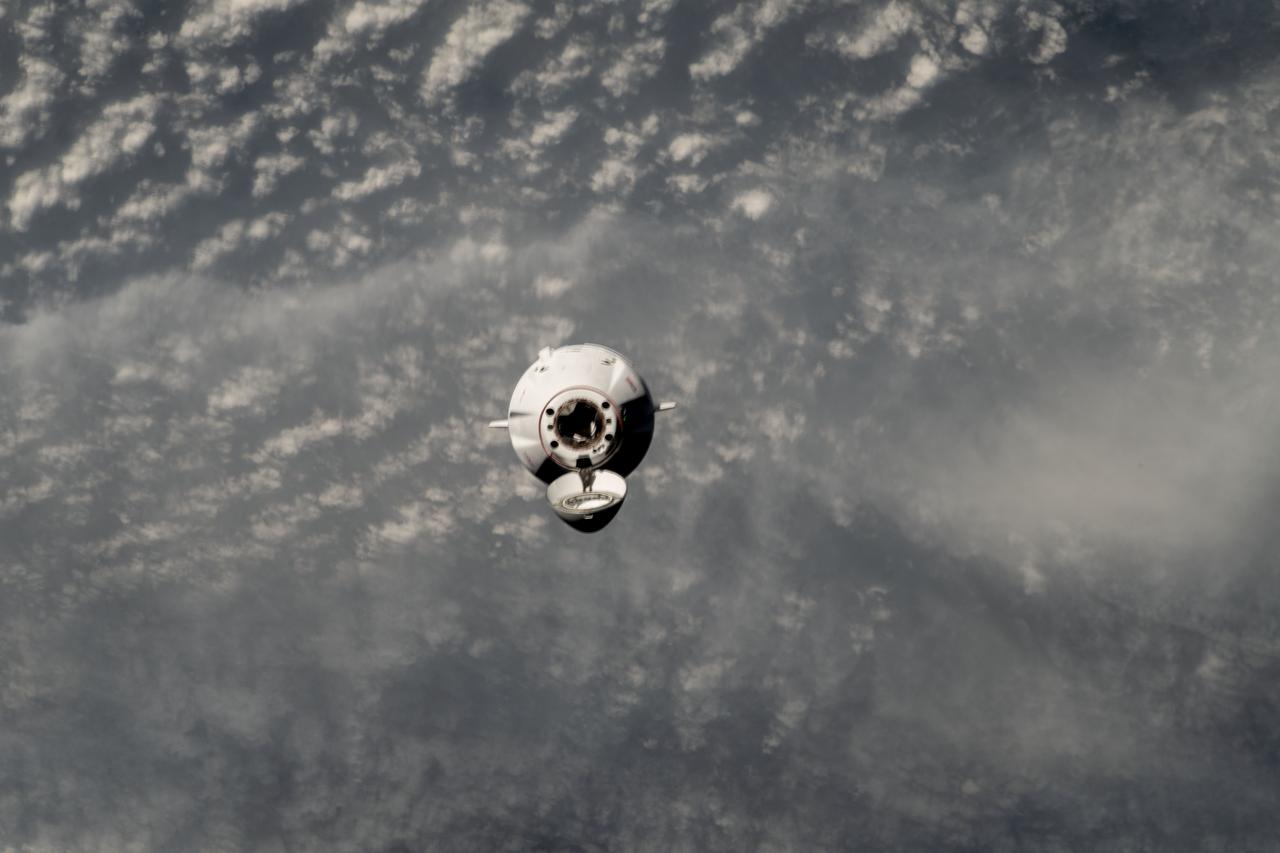
iss067e029160 (April 23, 2022) --- The Soyuz MS-21 crew ship is pictured docked to the Prichal docking module as the International Space Station orbited 260 miles above the Sea of Japan off the coast of South Korea.
iss068e021495 (Nov. 9, 2022) --- Golden Bay/Mohua in New Zealand is pictured from the International Space Station as it orbited 270 miles above the Tasman Sea. Credit: Koichi Wakata/Japan Aerospace Exploration Agency
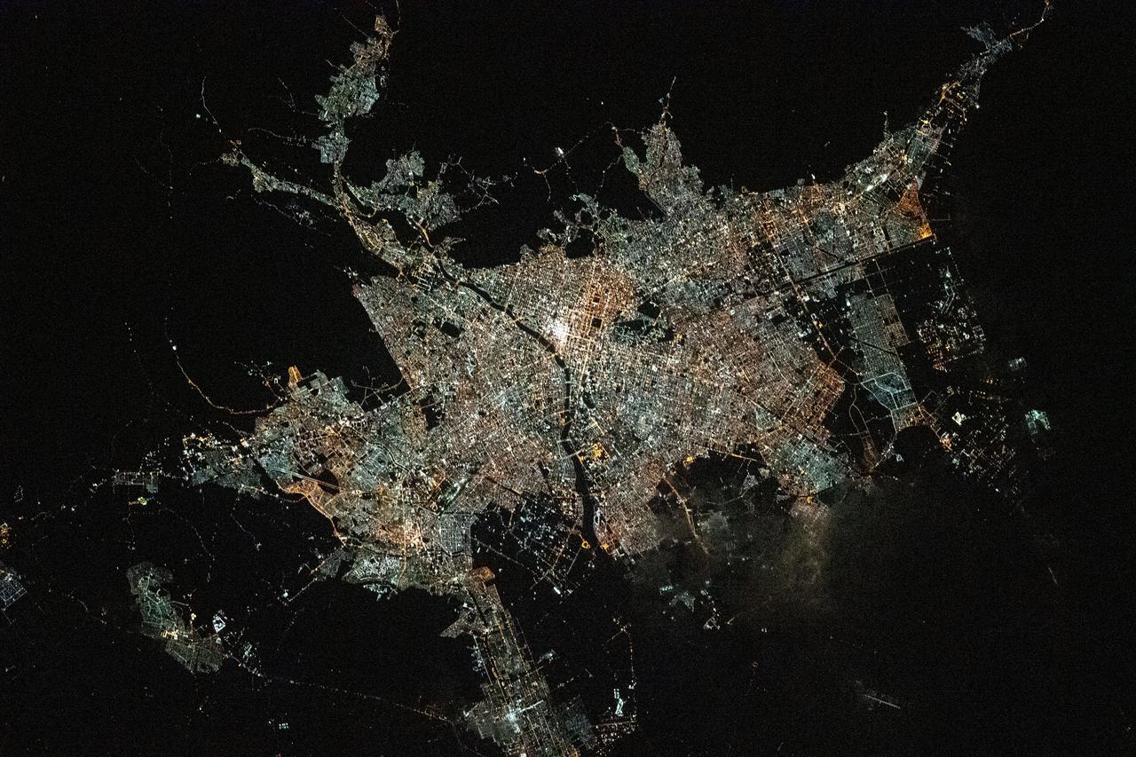
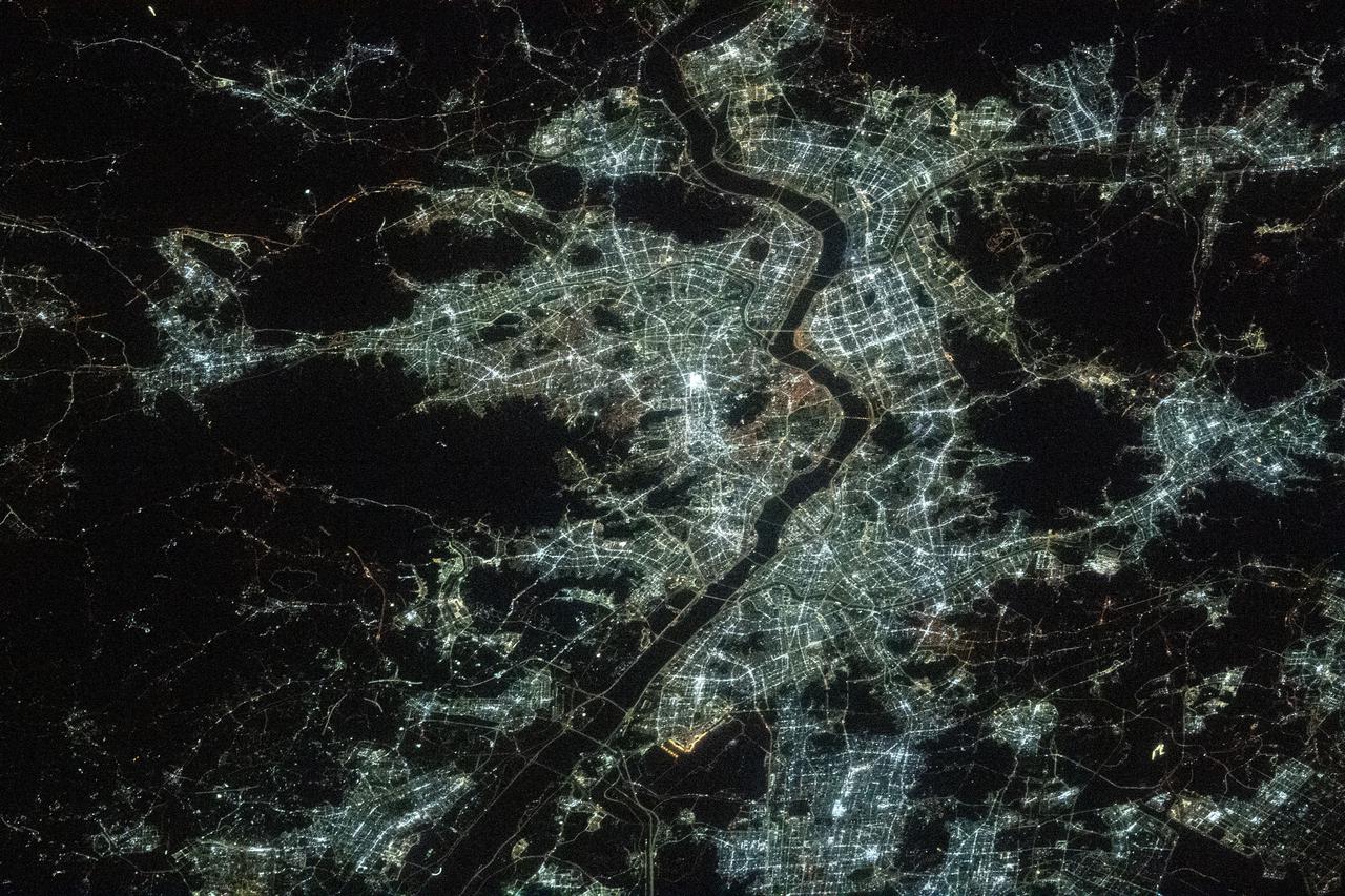
iss064e023814 (Jan. 18, 2021) --- This night time shot of of Tokyo, Yokohama, and the numerous municipalities surrounding Tokyo Bay, was taken from the International Space Station as it orbited 262 miles above the Sea of Japan.
iss066e158841 (March 8, 2022) --- Seoul, the capital of South Korea, split by the Han River, is pictured during an orbital night pass from the International Space Station at an altitude of 264 miles above the Sea of Japan.
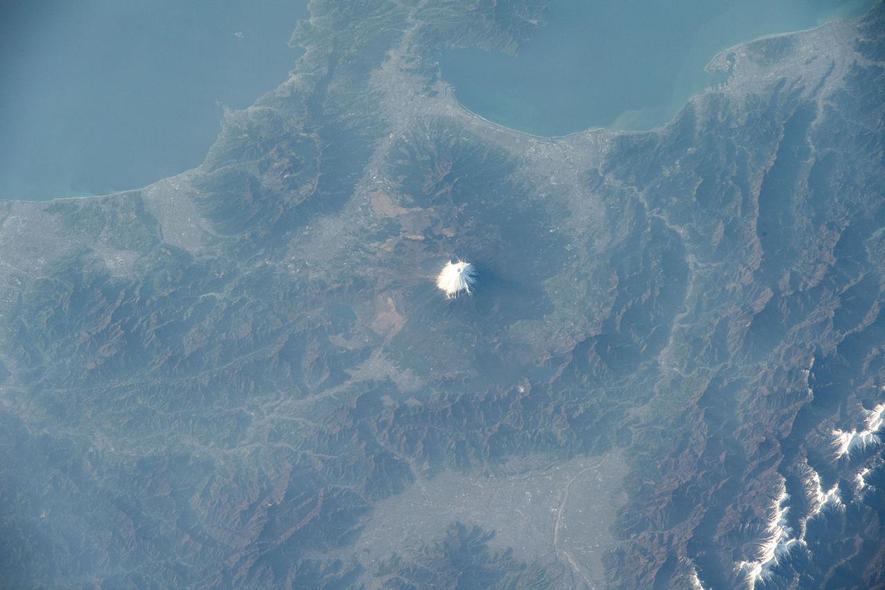
iss065e001158 (April 19, 2021) --- Mount Fuji, north of Suruga Bay and west of Tokyo, is pictured from the International Space Station as it orbited 264 miles above the Sea of Japan.
iss064e039403 (March 3, 2021) --- The well-lit nations of South Korea and Japan, as well as the lights of fishing boats in the East China Sea, are pictured from the International Station as it orbited 260 miles above.

iss064e025495 (Jan. 21, 2021) --- JAXA (Japan Aerospace Exploration Agency) astronaut and Expedition 64 Flight Engineer Soichi Noguchi enjoys the view of Earth below from the seven-windowed cupola as the International Space Station orbited 260 miles above the Caribbean Sea.
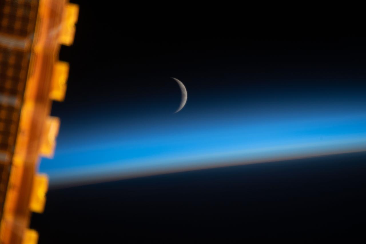
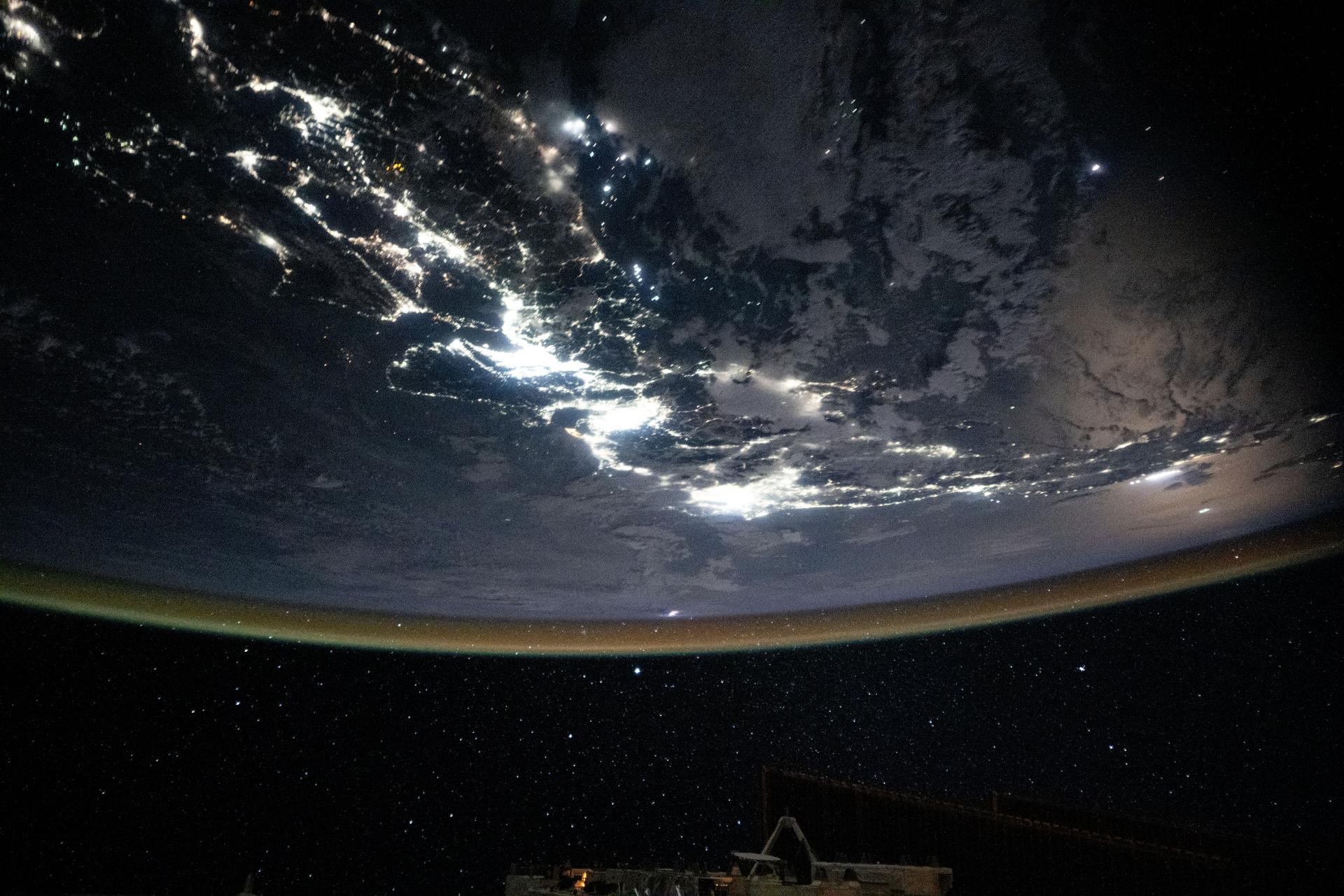
iss059e059210 (May 8, 2019) --- The waxing crescent moon is photographed just above Earth's limb and the bluish hue of the atmosphere at the beginning of an orbital sunrise. A portion of one of the International Space Station's solar arrays is seen in the left foreground as the orbital complex flew 258 miles above the Sea of Japan.

iss044e065321 (Aug. 24, 2015) --- JAXA's (Japan Aerospace Exploration Agency) H-II Transfer Vehicle-5, also known as the "Kounotori," is pictured during Expedition 44 in the grips of the International Space Station's Canadarm2 robotic arm as the orbital complex orbited above north Africa and across the Mediterranean Sea.

iss059e059211 (May 8, 2019) --- The waxing crescent moon is photographed just above Earth's limb and the bluish hue of the atmosphere at the beginning of an orbital sunrise. A portion of one of the International Space Station's solar arrays is seen in the left foreground as the orbital complex flew 258 miles above the Sea of Japan.
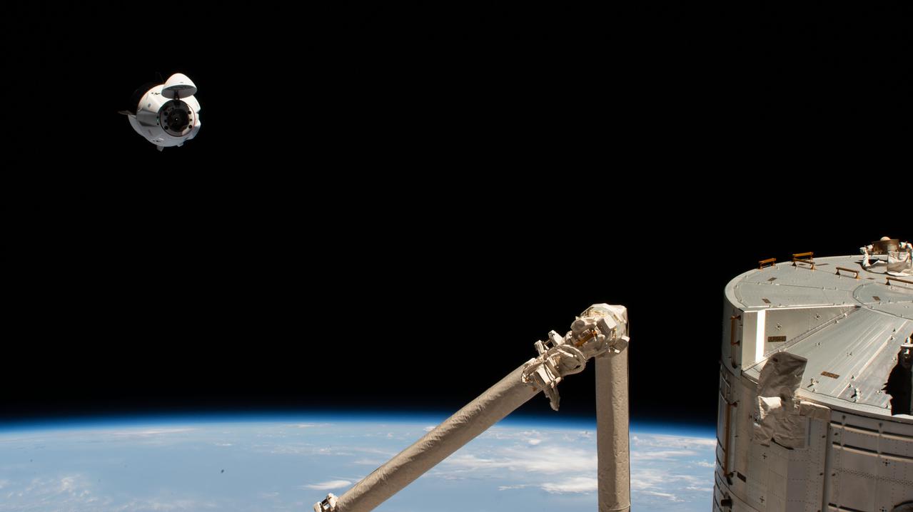
iss065e002827 (April 24, 2021) --- The SpaceX Crew Dragon Endeavour is pictured 262 miles above the Arabian Sea during its approach to the International Space Station. In the bottom right foreground, are portions of the Kibo laboratory module and the Japanese robotic arm, both from the Japan Aerospace Exploration Agency.
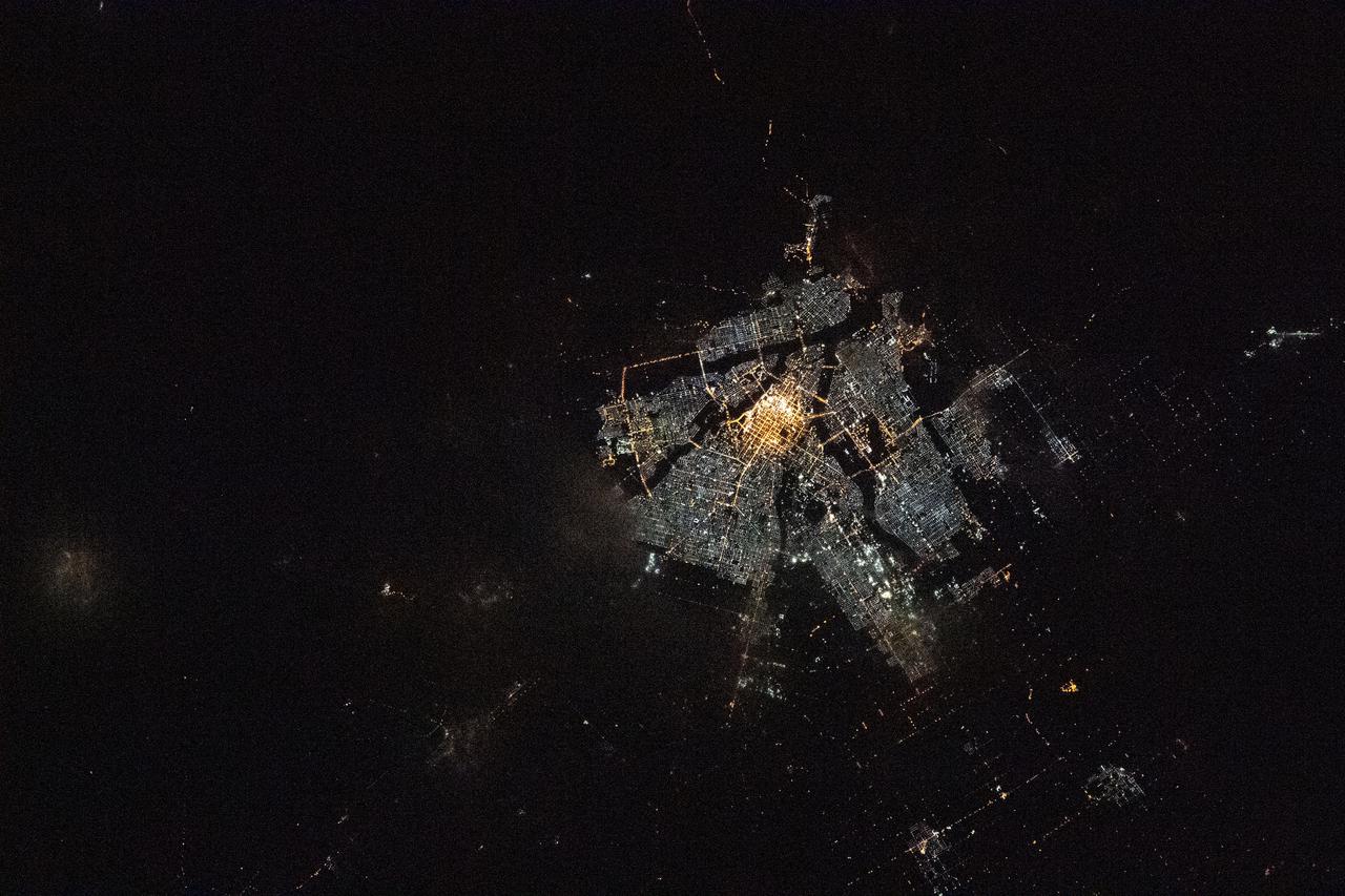
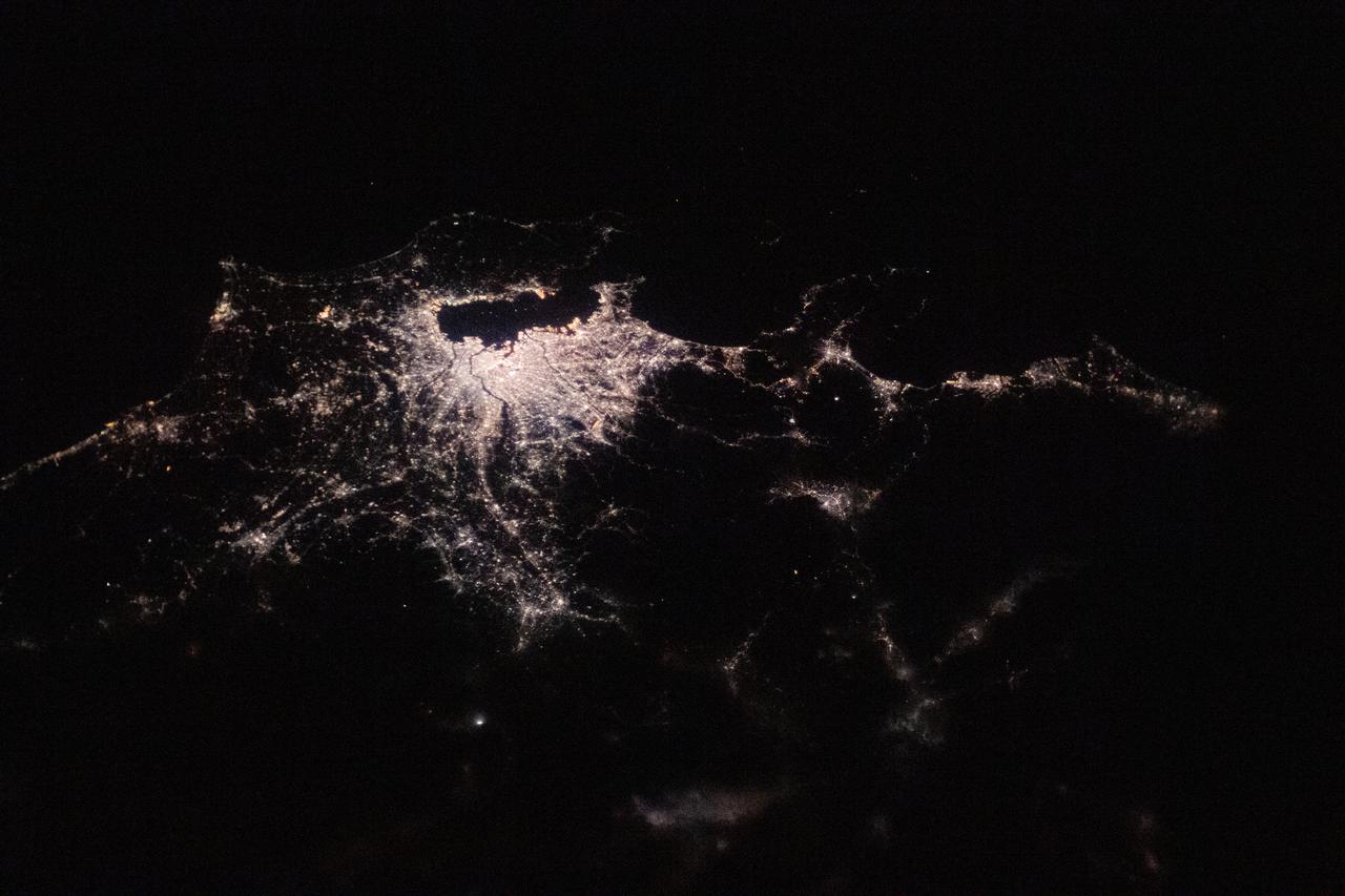
iss073e0003716 (April 24, 2025) --- Seoul, South Korea, the capital of the nation on the southern half of the Korean Peninsula with a population of about 9.6 million and split by the Han River, is pictured at approximately 2:58 a.m. local time from the International Space Station as it orbited 259 miles above the Sea of Japan.
iss073e0842595 (Sept. 15, 2025) --- City lights from Tokyo (center) to Osaka and Hiroshima (top left) illuminate Japan’s urban coastline, while moonlight glints off the Sea of Japan and the Pacific Ocean (lower right). The International Space Station was orbiting 262 miles above South Korea at approximately 1:56 a.m. local time when this photograph was taken.
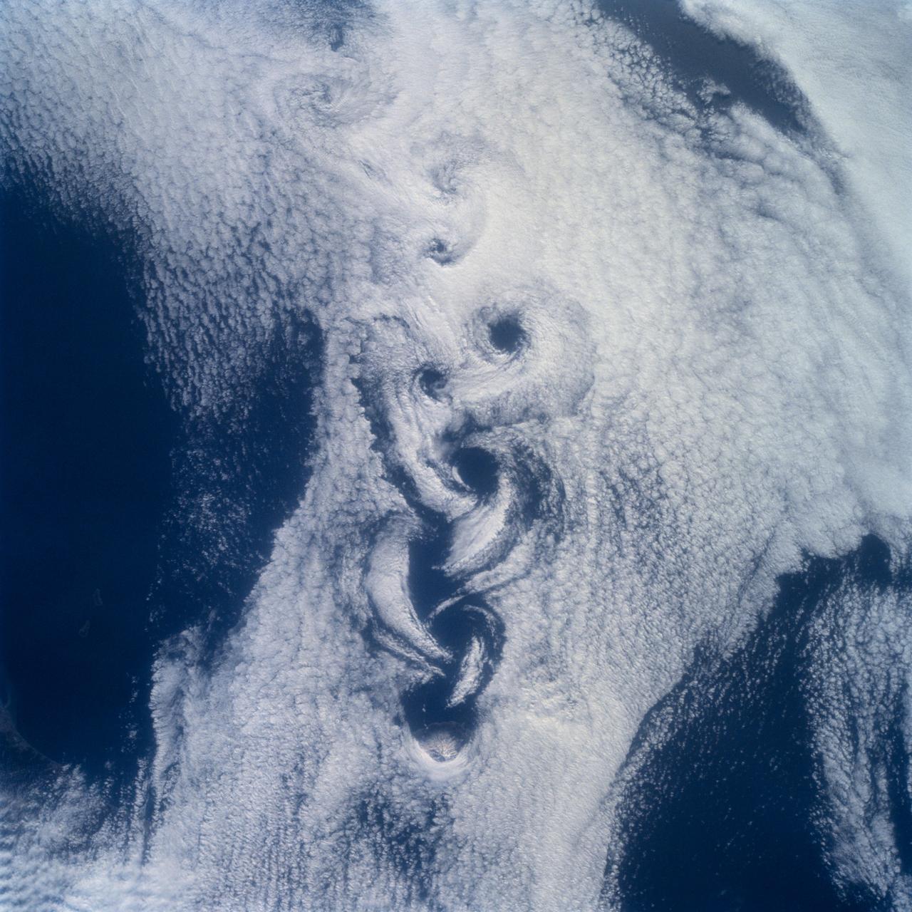
STS100-710-182 (19 April-1 May 2001) --- Easily recognizable in this STS-100 70mm frame are phenomena known as the von Karman vortices, which were forming in the stratocumulus field downwind from the volcanic island of Rishiri-to in the northern Sea of Japan off the northwest coast of Hokkaido, Japan. According to NASA scientists studying the STS-100 photo collection, these features form when a stable atmosphere with low clouds flows past a relatively small obstacle with a height greater than the depth of the cloud layer. Because the atmosphere is stable, a series of eddies form in the moving cloud field.
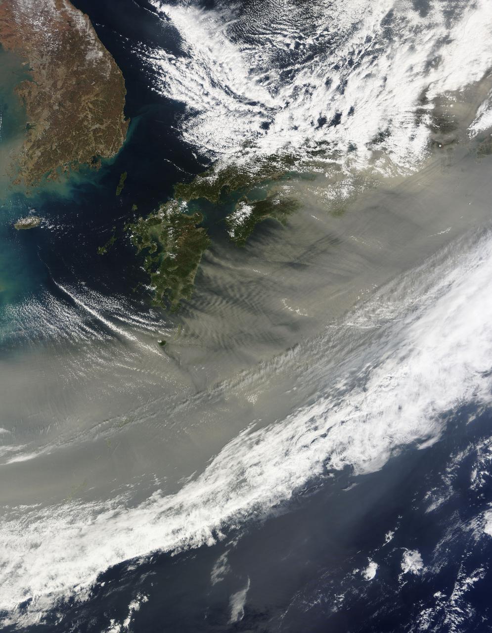
March 24, 2010 - Dust over Japan This image of gray/brown dust being blown over Japan was captured on March 21, 2010 by the MODIS on the Terra satellite. On the left is the Korean peninsula. Japan stretches diagonally across the image, up to the top right corner. The dust is likely from the sandstorm that swept across the China the previous day. The sand and dust originated from the south and east of Inner Mongolia. In this image from March 20, the dust is nearly obscuring the Bohai Sea, which is just west of the Korean peninsula. Here is a handy map. For more information related to this image go to: <a href="http://modis.gsfc.nasa.gov/gallery/individual.php?db_date=2010-03-24" rel="nofollow">modis.gsfc.nasa.gov/gallery/individual.php?db_date=2010-0...</a> For more information about Goddard Space Flight Center go here: <a href="http://www.nasa.gov/centers/goddard/home/index.html" rel="nofollow">www.nasa.gov/centers/goddard/home/index.html</a>
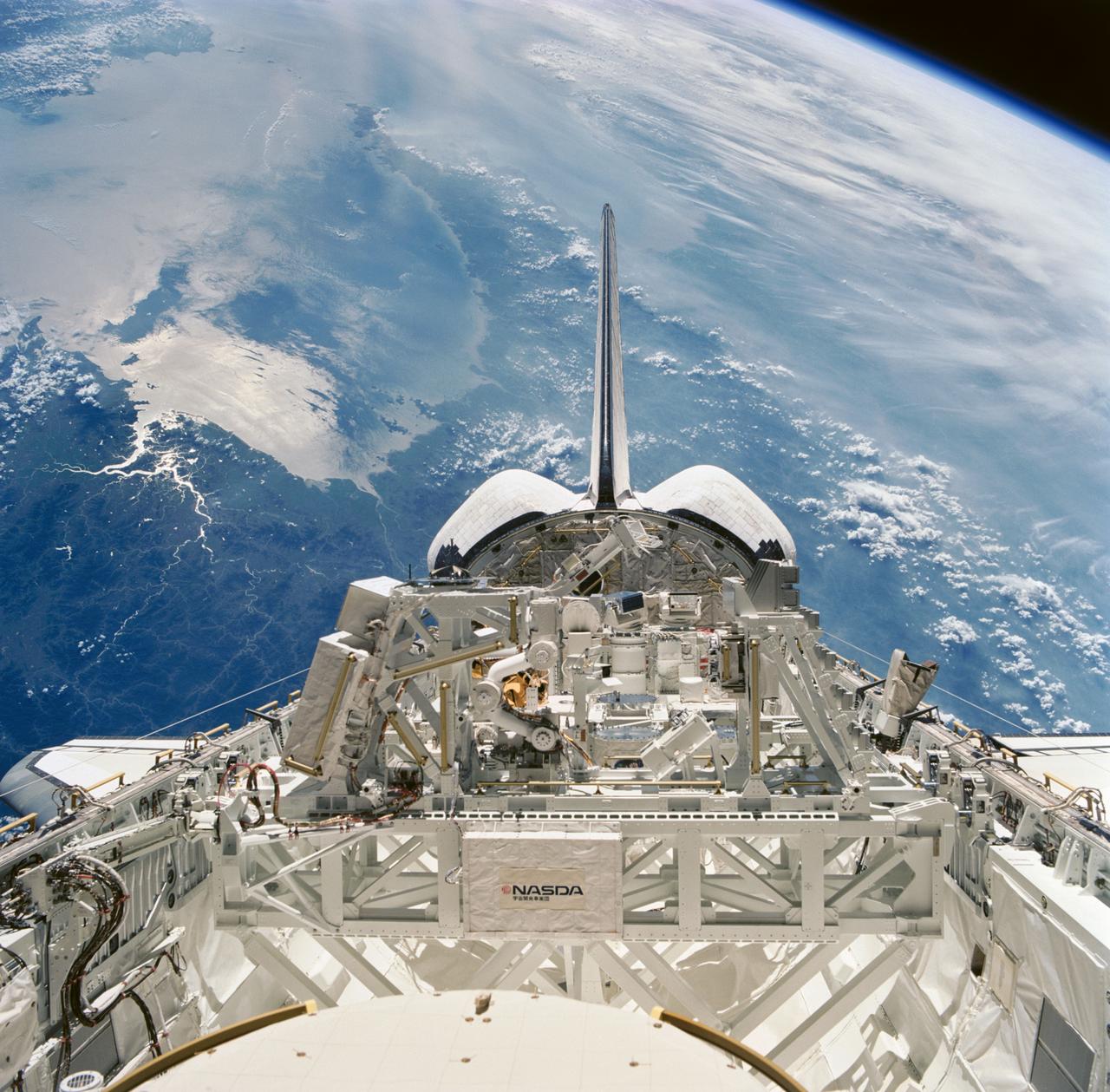
STS085-751-039 (7 - 19 August 1997) --- This 70mm frame, exposed through aft flight deck windows of the Space Shuttle Discovery, shows experiments in the cargo bay, as the spacecraft was flying over the Sea of Japan. In center foreground is the Manipulator Flight Demonstration (MFD). The MFD, sponsored by National Space Development Agency (NASDA), will evaluate the use of the Small Fine Arm (SFA) that is planned to be part of the future Japanese Experiment Module's (JEM) Remote Manipulator System (RMS) on the International Space Station (ISS).
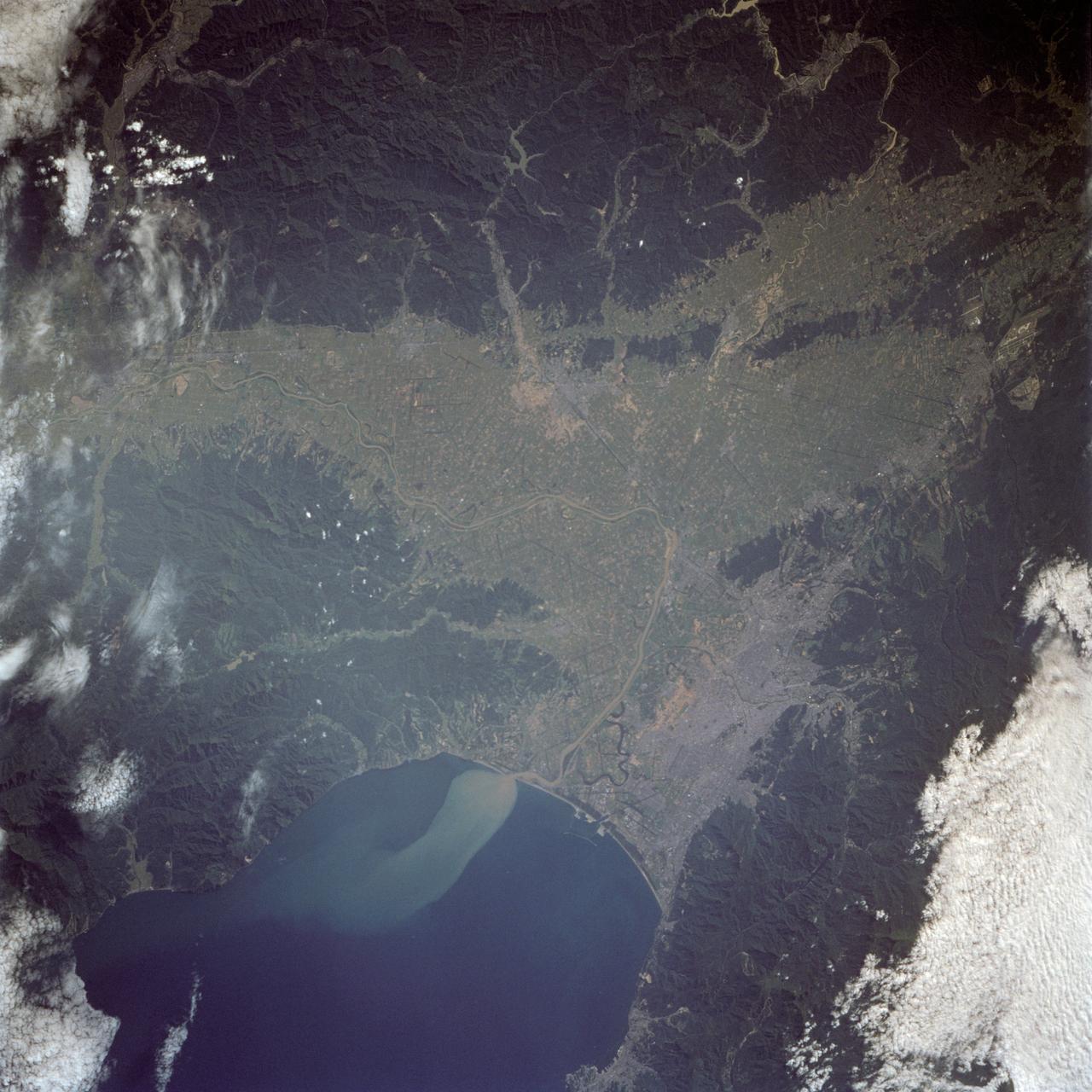
The city of Sapporo on the northernmost of the Japanese Home Island of Hokkaido (43.5N, 141.5E), host to the 1986 Winter Olympic Games is situated along the margin of a large valley which extends across the island from the Sea of Japan to the Pacific Ocean. The Valley is largely cultivated (the lighter green of the cultivated land distinguishes it from the gray urban development of Sapporo), but much of the island remains heavily forested.
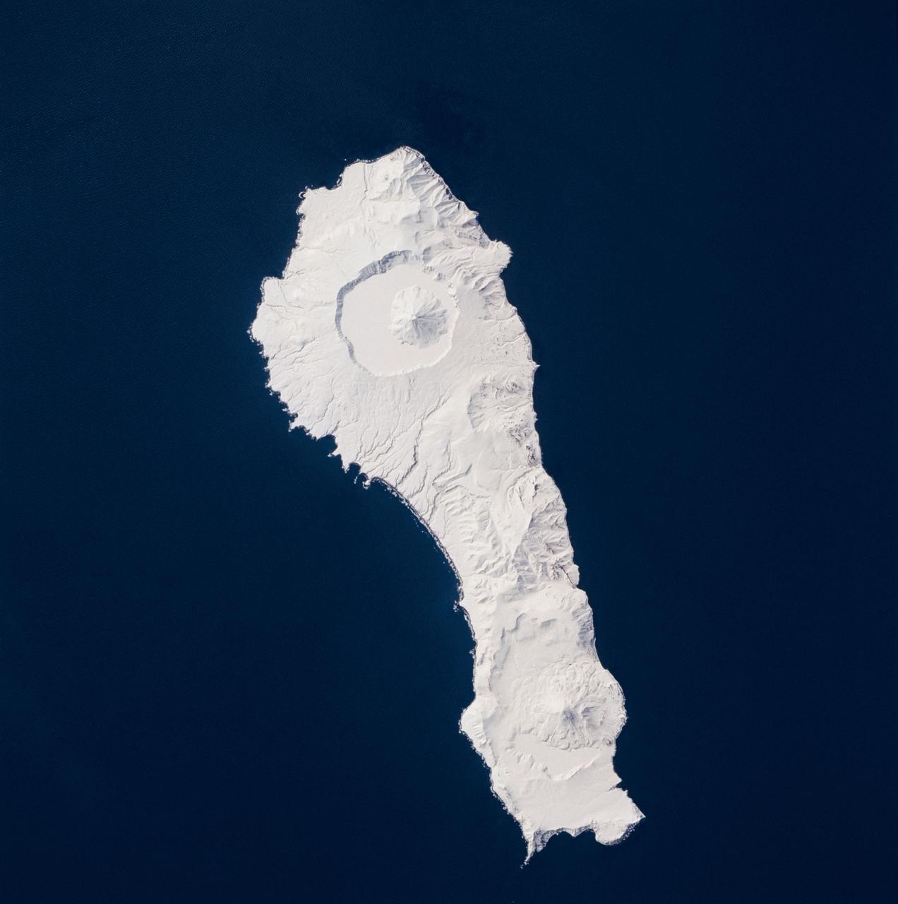
STS059-219-065 (9-20 April 1994) --- The narrow end of the island is to the north by northeast. This is one of several volcanic islands extending south by southwest between the southern tip of Kamchatka and Japan. The exposure was stopped down to provide extremely fine detail in the totally snow-covered landscape, at the same time making the dark sea look completely black. Compare to STS047-90-087, taken in September, which shows a green ground cover. Hasselblad photograph.
Okata is a small village of about 3,000 residents in northwest Japan. It is known internationally for its Solar-car rally. The village consists entirely of land reclaimed from the former Lake Hachirogata, and is mostly below sea level (Wikipedia). The image was acquired August 28, 2012, covers an area of 17.5 by 22.8 km, and is located at 40 degrees north, 139.9 degrees east. https://photojournal.jpl.nasa.gov/catalog/PIA23531

Stable, south flowing air over the western Pacific Ocean (26.0N, 131.0E) is disturbed by islands south of Korea, resulting in sinuous clouds known as von Karman vortices. The smoke plume from Japan's Mount Unzen Volcano on Kyushu, is visible just west of the large cloud mass and extending southward. A very large, purple tinged dust pall, originating in Mongolia, can be seen on the Earth's Limb, covering eastern China and extending into the East China Sea.
iss069e018140 (June 6, 2023) --- The SpaceX Dragon cargo craft approaches the International Space Station for an automated docking less than a day after launching from NASA's Kennedy Space Center loaded with over 7,000 pounds of science experiments, station hardware, and crew supplies. Both spacecraft were orbiting 259 miles above the Sea of Japan at the time of this photograph from the orbital outpost.

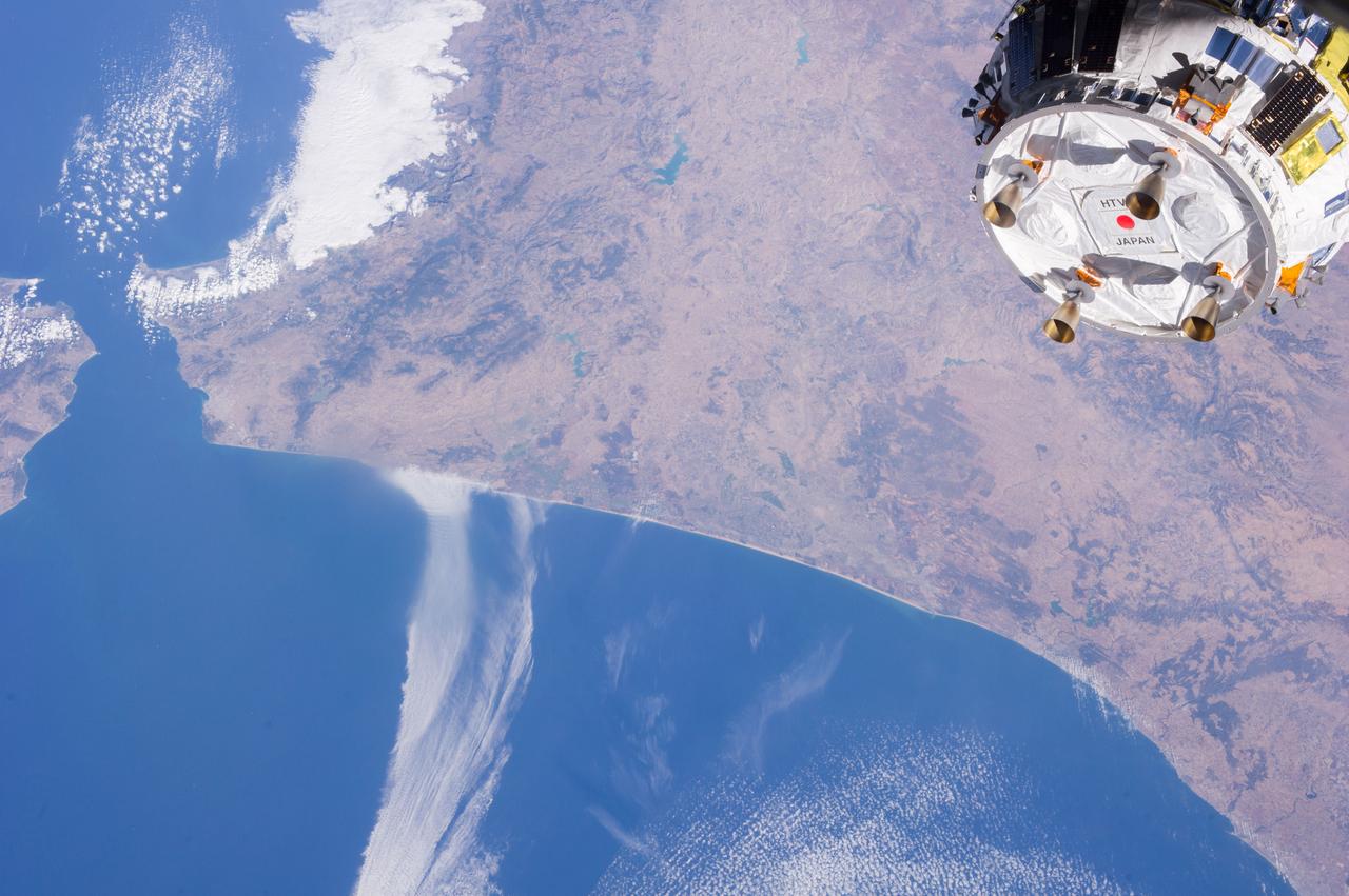
iss057e000244 (Oct. 6, 2018) --- A image captured from a time-lapse imagery sequence shows north Africa and the Mediterranean Sea as the International Space Station orbited 254 miles above the African continent. Japan's Kounotori H-II Transfer Vehicle-7 (HTV-7) is pictured at left attached to the Harmony module. Portions of the station's solar arrays and radiators are pictured at left.
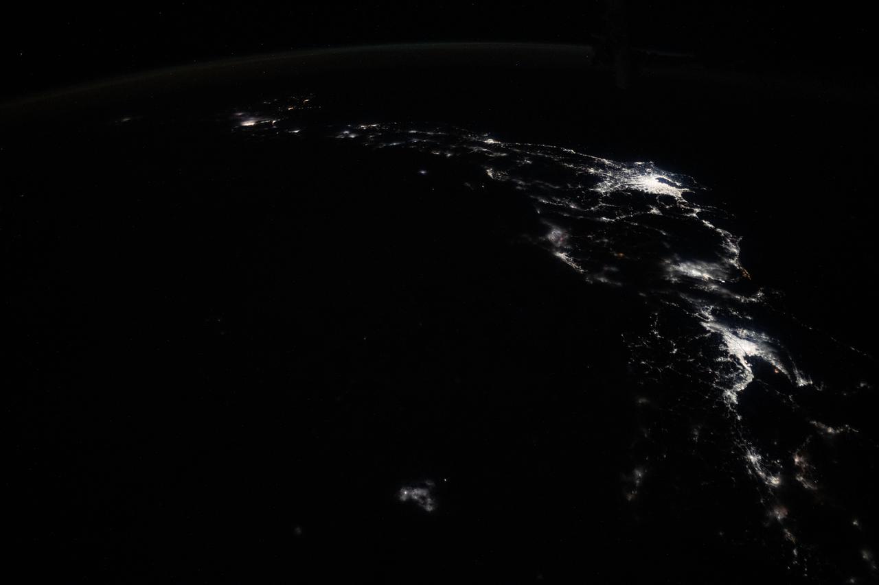
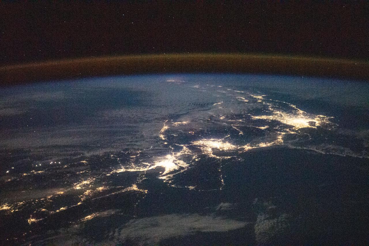
iss073e0703552 (Sept. 18, 2025) --- City lights trace the Japanese coastline underneath a dim yellow-green airglow in this nighttime view across the Sea of Japan, revealing the metropolitan areas (from left to right) of Sapporo, Sendai, Tokyo, and Nagoya. The International Space Station was orbiting 262 miles above Russia’s far eastern coast when this image was captured at approximately 11:29 p.m. local time.
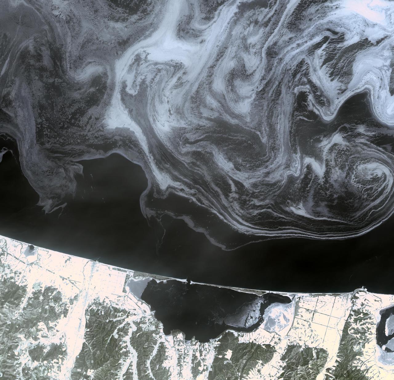
ISS039-E-11773 (14 April 2014) --- Photographed with a camera equipped with an 80mm lens from the International Space Station, patterns of sea ice in the Sea of Okhotsk reveal the dynamics of ocean currents that could otherwise only be seen in sunglint. In this Expedition 39 photo, one can see nearly 1,000 kilometers (600 miles) of the East Sakhalin Current, which is carrying winter ice south toward Japan’s Hokkaido Island. The current is marked by the narrow corridor of dense ice that hugs the coast of Russia’s Sakhalin Island. As it approaches Hokkaido, the ice patterns show a series of eddies and swirls. The East Sakhalin Current wanes in summer when the Soya Current begins to enter the Sea of Okhotsk. This inrush of summer water starts in April and, according to NASA scientists, probably expresses itself in this image as ice pattern to the east above Hokkaido. The Sakhalin current turns east and transports ice toward the Kuril Island chain. Some ice can spill through gaps in the islands, where it is swept southwest by the Kuril Current (lower right).

ISS034-E-016601 (4 Jan. 2013) --- On Jan. 4 a large presence of stratocumulus clouds was the central focus of camera lenses which remained aimed at the clouds as the Expedition 34 crew members aboard the International Space Station flew above the northwestern Pacific Ocean about 460 miles east of northern Honshu, Japan. This is a descending pass with a panoramic view looking southeast in late afternoon light with the terminator (upper left). The cloud pattern is typical for this part of the world. The low clouds carry cold air over a warmer sea with no discernable storm pattern.

iss073e0515603 (Aug. 24, 2025) --- Shanghai, China, situated on the Yangtze River where it meets the East China Sea, is pictured at approximately 1:32 a.m. local time from the International Space Station as it orbited 261 miles above the nation's eastern coastline. Visible landmarks include Shanghai Hongqiao International Airport near the top of the frame and Shanghai Pudong International Airport at the bottom. The city's lights appear dimmer from orbit due to the widespread use of modern, downward-facing, energy-efficient lighting that reduces light pollution. Credit: JAXA (Japan Aerospace Exploration Agency)

iss073e1196921 (Nov. 25, 2025) --- Northrop Grumman's Cygnus XL cargo craft is pictured in the grips of the International Space Station Canadarm2 robotic arm. Cygnus XL had been temporarily released from its Earth-facing port on the Unity module to make room for the Soyuz MS-28 crew spacecraft, which was scheduled to arrive the next day and dock to the Rassvet module. JAXA's (Japan Aerospace Exploration Agency) HTV-X1 cargo craft, with its solar arrays deployed, is seen berthed to the Earth-facing port of the Harmony module. The orbital outpost was soaring 262 miles above the Caribbean Sea south of Cuba at the time of this photograph.

iss073e1196882 (Nov. 25, 2025) --- Northrop Grumman's Cygnus XL cargo craft is pictured in the grips of the International Space Station Canadarm2 robotic arm. Cygnus XL had been temporarily released from its Earth-facing port on the Unity module to make room for the Soyuz MS-28 crew spacecraft, which was scheduled to arrive the next day and dock to the Rassvet module. JAXA's (Japan Aerospace Exploration Agency) HTV-X1 cargo craft, with its solar arrays deployed, is seen berthed to the Earth-facing port of the Harmony module. The orbital outpost was soaring 262 miles above the Caribbean Sea east of the Yucatan Peninsula.

iss073e1196940 (Nov. 25, 2025) --- Northrop Grumman's Cygnus XL cargo craft is pictured in the grips of the International Space Station Canadarm2 robotic arm. Cygnus XL had been temporarily released from its Earth-facing port on the Unity module to make room for the Soyuz MS-28 crew spacecraft, which was scheduled to arrive the next day and dock to the Rassvet module. JAXA's (Japan Aerospace Exploration Agency) HTV-X1 cargo craft, with its solar arrays deployed, is seen berthed to the Earth-facing port of the Harmony module. The orbital outpost was soaring 261 miles above the Caribbean Sea south of Cuba at the time of this photograph.
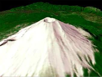
The nearly perfectly conical profile of Fuji soars 3,776 meters (12,388 feet) above sea level on southern Honshu, near Tokyo. The highest mountain in Japan, Fuji is the country's most familiar symbol. The summit of this graceful, dormant volcano is broken by a crater 610 meters (2,000 feet) in diameter. The crater is ringed by eight jagged peaks. The five Fuji Lakes lie on the northern slopes of the mountain, all formed in the wake of lava flows. Mirrored in the still waters of Kawaguchi-ko, the most beautiful of the five lakes, is a reflection of Fuji. Part of Fuji-Hakone-Izu National Park, Fuji last erupted for a two-month period starting in November 1707, covering Tokyo, some 100 kilometers (60 miles) away, with a layer of ash. According to legend, Fuji arose from the plain during a single night in 286 BC. Geologically, the mountain is much older than this. Considered sacred by many, Fuji is surrounded by temples and shrines. Thousands of pilgrims climb the mountain each year as part of their religious practice, hoping to reach the summit by dawn to watch the sunrise. This animated fly-by was created by draping visible and near infrared image data over a digital topography model, created from ASTER's stereo bands. The spatial resolution of both the image and topography is 15 m. The image is centered at 35.3 degrees north latitude, 138.7 degrees east longitude. http://photojournal.jpl.nasa.gov/catalog/PIA11166
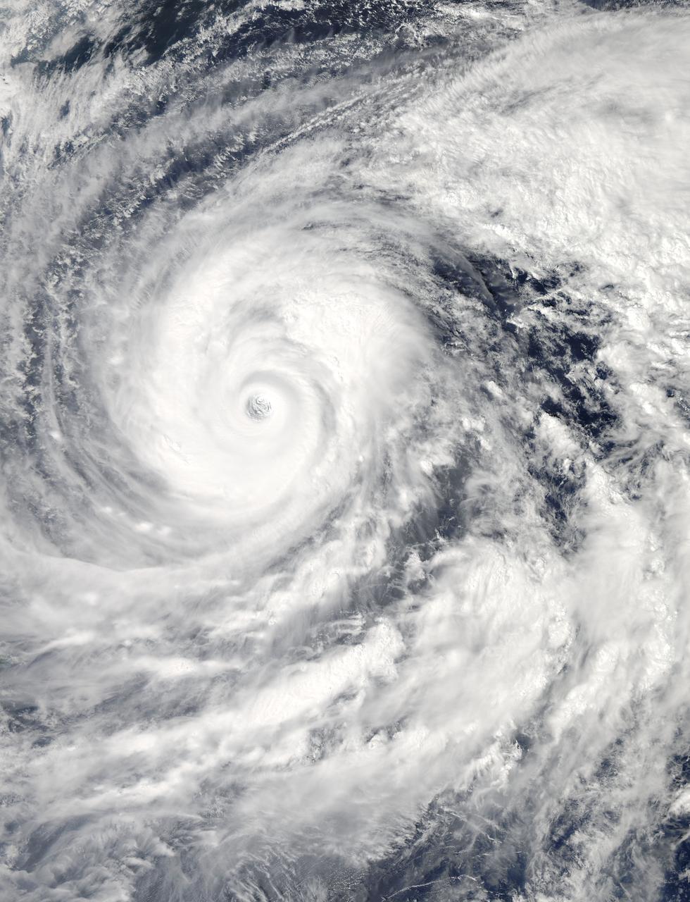
The MODIS instrument aboard NASA's Aqua satellite captured this visible image of Super Typhoon Vongfong on Oct. 9 at 04:25 UTC (12:25 a.m. EDT as it moved north through the Philippine Sea. Credit: NASA Goddard MODIS Rapid Response Team --- Vongfong weakened to a Category 4 typhoon on the Saffir-Simpson scale on Thursday, October 9, with maximum sustained winds near 130 knots (149.6 mph/240.8 kph), down from a Category 5 typhoon on Oct. 8. Forecasters at the Joint Typhoon Warning Center predict slow weakening over the next several days. Vongfong was centered near 20.6 north and 129.5 east, about 384 nautical miles south-southeast of Kadena Air Base, Okinawa, Japan. It is moving to the north-northwest at 7 knots (8 mph/12.9 kph) and generating 44 foot (13.4 meter) high seas. For warnings and watches, visit the Japan Meteorological Agency website at: <a href="http://www.jma.go.jp/en/typh/" rel="nofollow">www.jma.go.jp/en/typh/</a>. Vongfong is forecast to continue moving north through the Philippine Sea and is expected to pass just to the east of Kadena Air Base, then track over Amami Oshima before making landfall in Kyushu and moving over the other three big islands of Japan. Residents of all of these islands should prepare for typhoon conditions beginning on October 10. Read more: <a href="http://1.usa.gov/1s0CCQy" rel="nofollow">1.usa.gov/1s0CCQy</a> <b><a href="http://www.nasa.gov/audience/formedia/features/MP_Photo_Guidelines.html" rel="nofollow">NASA image use policy.</a></b> <b><a href="http://www.nasa.gov/centers/goddard/home/index.html" rel="nofollow">NASA Goddard Space Flight Center</a></b> enables NASA’s mission through four scientific endeavors: Earth Science, Heliophysics, Solar System Exploration, and Astrophysics. Goddard plays a leading role in NASA’s accomplishments by contributing compelling scientific knowledge to advance the Agency’s mission. <b>Follow us on <a href="http://twitter.com/NASAGoddardPix" rel="nofollow">Twitter</a></b> <b>Like us on <a href="http://www.facebook.com/pages/Greenbelt-MD/NASA-Goddard/395013845897?ref=tsd" rel="nofollow">Facebook</a></b> <b>Find us on <a href="http://instagram.com/nasagoddard?vm=grid" rel="nofollow">Instagram</a></b>
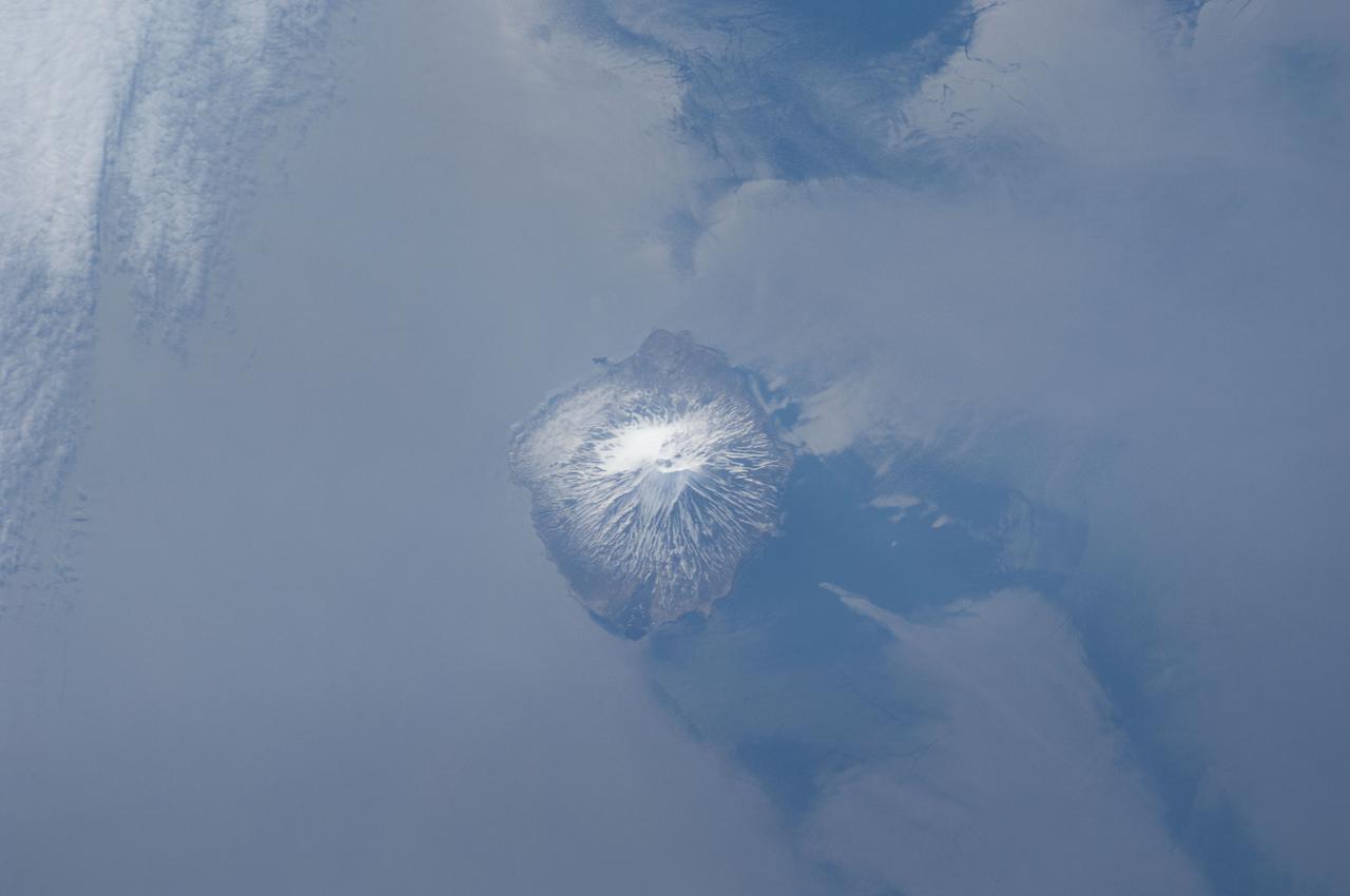
ISS031-E-041959 (18 May 2012) --- Alaid Volcano in the Kuril Islands of the Russian Federation is featured in this image photographed by an Expedition 31 crew member on the International Space Station. The Kurils chain extends from the Kamchatka Peninsula to the islands of Japan, and contains numerous active volcanoes along its length. Alaid is the highest (2,339 meters above sea level) volcano in the Kuril chain, as well as being the northernmost. The textbook conic morphology of this stratovolcano is marred only by the summit crater, which is breached to the south (center) and highlighted by snow cover. The volcano rises 3,000 meters directly from the floor of the Sea of Okhotsk, with the uppermost part of the volcanic edifice exposed as an island. Much of the sea surface surrounding the volcano has a silver-gray appearance. This mirror-like appearance is due to sunglint, where light reflects off the sea surface and is scattered directly towards the observer onboard the space station. Sunglint is largely absent from a zone directly to the west of the volcano, most likely due to surface wind or water current patterns that change the roughness?and light scattering properties?of the water surface in this area. Volcanoes in the Kurils, and similar island arcs in the Pacific ?ring of fire?, are fed by magma generated along the boundary between two tectonic plates, where one plate is being driven beneath the other (a process known as subduction). Alaid Volcano has been historically active with the most recent confirmed explosive activity occurring in 1996.
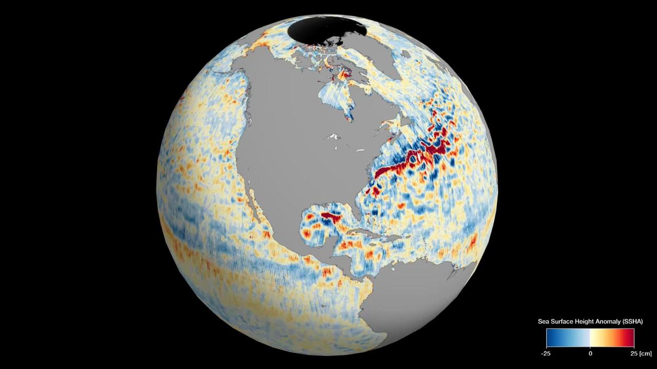
This animation shows global sea level data collected by the Surface Water and Ocean Topography (SWOT) satellite during its first 21-day science orbit, which it completed from July 26 to Aug. 16, 2023. Red and orange indicate ocean heights that were higher than the global mean sea surface height, while blue represents lower-than-the mean. Sea level differences can highlight ocean currents, like the Gulf Stream coming off the U.S. East Coast or the Kuroshio current off the east coast of Japan. Increased sea surface heights can also indicate regions of relatively warmer water – like the eastern part of the equatorial Pacific Ocean during an El Niño – because water expands as it warms. The SWOT science team made the measurements using the spacecraft's Ka-band Radar Interferometer (KaRIn) instrument. With two antennas spread 33 feet (10 meters) apart on a boom, KaRIn produces a pair of data swaths (tracks visible in the animation) as it circles the globe, bouncing radar pulses off the water's surface to collect surface-height measurements. Launched on Dec. 16, 2022, from Vandenberg Space Force Base in central California, SWOT is now in its operations phase, measuring the height of nearly all water on Earth's surface. The satellite will provide one of the most detailed, comprehensive views yet of the planet's oceans and fresh water lakes and rivers, collecting data that will be used for research and other purposes. Animation available at https://photojournal.jpl.nasa.gov/catalog/PIA26100
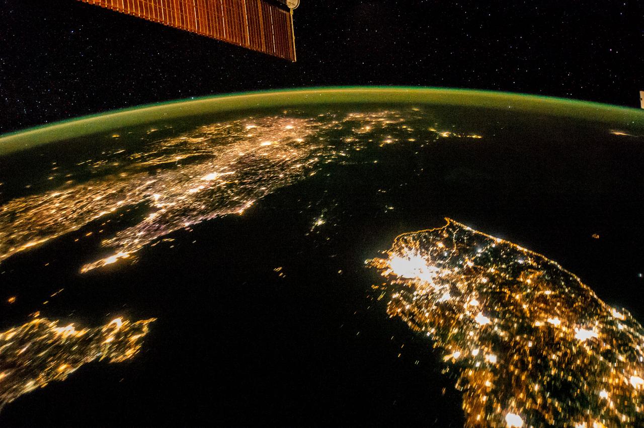
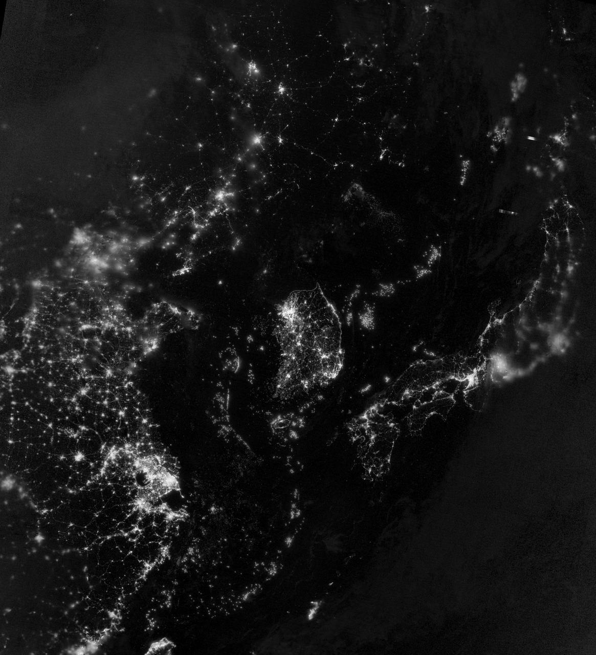
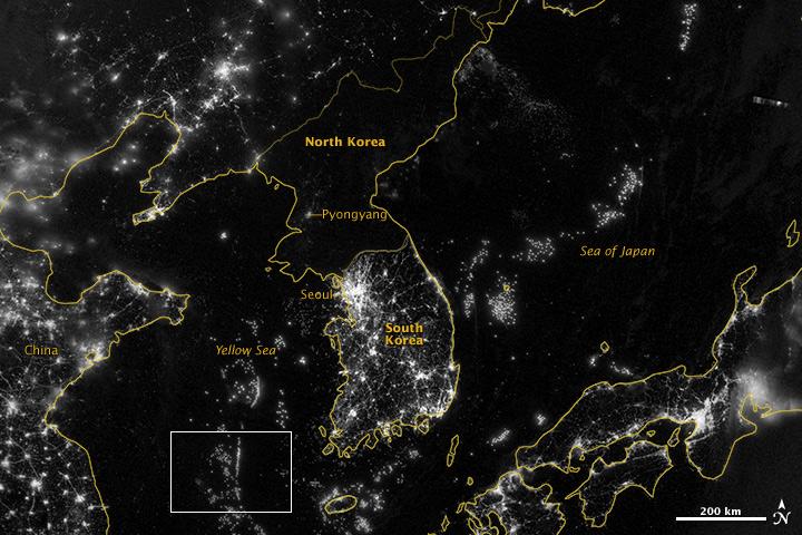
ISS038-E-038300 (30 Jan. 2014) --- Flying over East Asia, an Expedition 38 crew member on the International Space Station took this night image of the Korean Peninsula. Unlike daylight images, city lights at night illustrate dramatically the relative economic importance of cities, as gauged by relative size. In this north-looking view, it is immediately obvious that greater Seoul is a major city and that the port of Gunsan is minor by comparison. There are 25.6 million people in the Seoul metropolitan area-more than half of South Korea's citizens-while Gunsan's population is 280,000. North Korea is almost completely dark compared to neighboring South Korea and China. The darkened land appears as if it were a patch of water joining the Yellow Sea to the Sea of Japan. The capital city, Pyongyang, appears like a small island, despite a population of 3.26 million (as of 2008). The light emission from Pyongyang is equivalent to the smaller towns in South Korea. Coastlines are often very apparent in night imagery, as shown by South Korea's eastern shoreline. But the coast of North Korea is difficult to detect. These differences are illustrated in per capita power consumption in the two countries, with South Korea at 10,162 kilowatt hours and North Korea at 739 kilowatt hours.
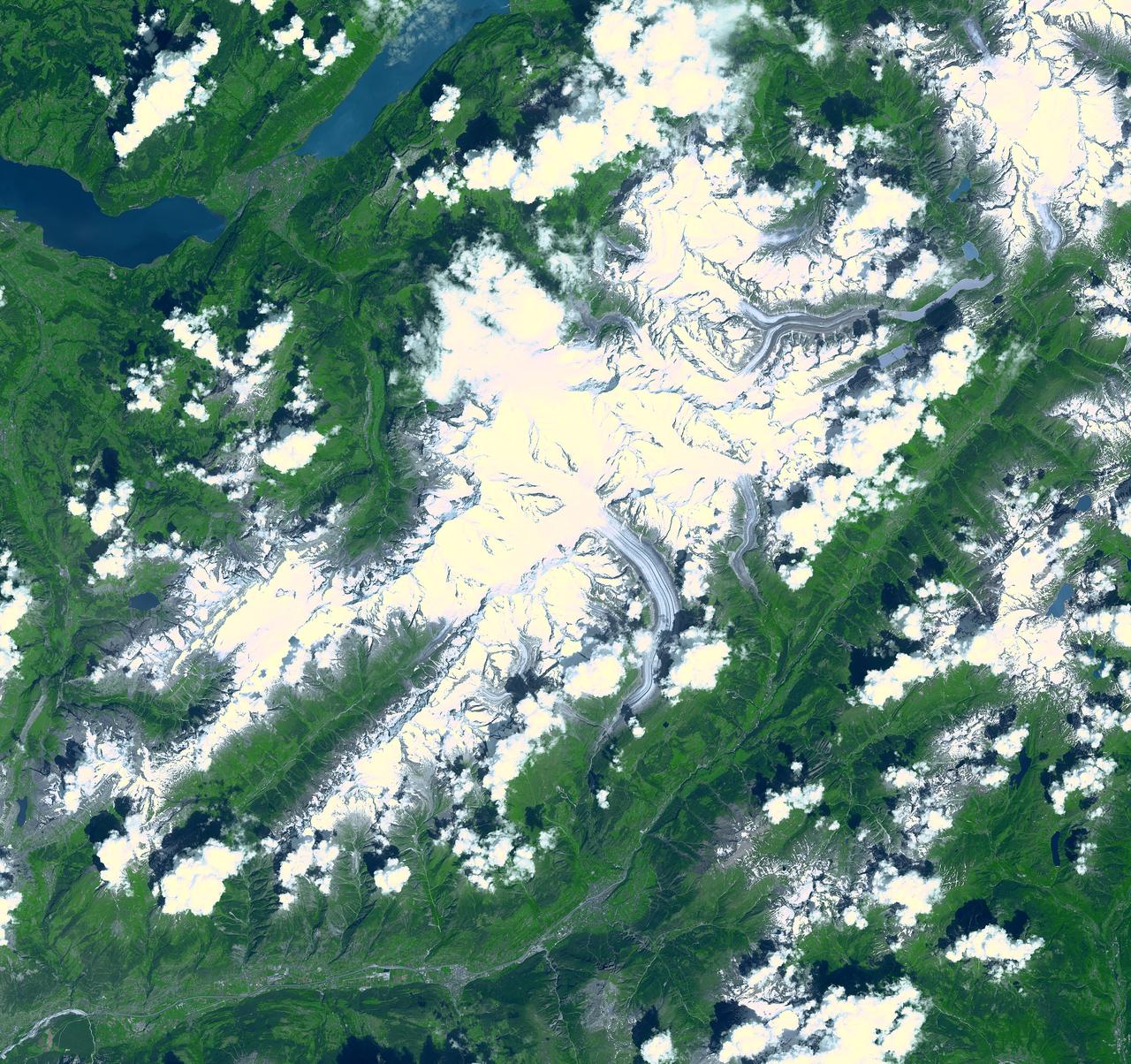
Aletsch Glacier, the largest glacier of Europe, covers more than 120 square kilometers (more than 45 square miles) in southern Switzerland. At its eastern extremity lies a glacierlake, Mdrjelensee (2,350 meters/7,711 feet above sea level). To the west rises Aletschhorn (4,195 meters/13,763 feet), which was first climbed in 1859. The Rhone River flows along the southern flank of the mountains. This image was acquired on July 23, 2001 by the Advanced Spaceborne Thermal Emission and Reflection Radiometer (ASTER) on NASA's Terra satellite. With its 14 spectral bands from the visible to the thermal infrared wavelength region, and its high spatial resolution of 15 to 90 meters (about 50 to 300 feet), ASTER will image Earth for the next 6 years to map and monitor the changing surface of our planet. ASTER is one of five Earth-observing instruments launched December 18, 1999, on NASA's Terra satellite. The instrument was built by Japan's Ministry of Economy, Trade and Industry. A joint U.S./Japan science team is responsible for validation and calibration of the instrument and the data products. http://photojournal.jpl.nasa.gov/catalog/PIA03857

This artist's concept depicts the completely assembled International Space Station (ISS) passing over the Straits of Gibraltar and the Mediterranean Sea. As a gateway to permanent human presence in space, the Space Station Program is to expand knowledge benefiting all people and nations. The ISS is a multidisciplinary laboratory, technology test bed, and observatory that will provide unprecedented undertakings in scientific, technological, and international experimentation. Experiments to be conducted in the ISS include: microgravity research, Earth science, space science, life sciences, space product development, and engineering research and technology. The sixteen countries participating the ISS are: United States, Russian Federation, Canada, Japan, United Kingdom, Germany, Italy, France, Norway, Netherlands, Belgium, Spain, Denmark, Sweden, Switzerland, and Brazil.
ISS036-E-039525 (04 Sept. 2013) --- One of the Expedition 36 crew members aboard the International Space Station took this picture showing part of the Japanese HTV-4 unmanned cargo spacecraft, backdropped against countries in northern Africa, following its unberthing from the orbital outpost. HTV-4, after backing away from the flying complex, headed for re-entry into Earth's atmosphere, burning upon re-entry. The Strait of Gibraltar, where the Atlantic Ocean and the Mediterranean Sea meet, is in the upper left quadrant of the photo. HTV-4 was launched by Japan?s Aerospace Exploration Agency (JAXA) on Aug. 4 of this year in order to bring up supplies for the astronauts and cosmonauts onboard the station.
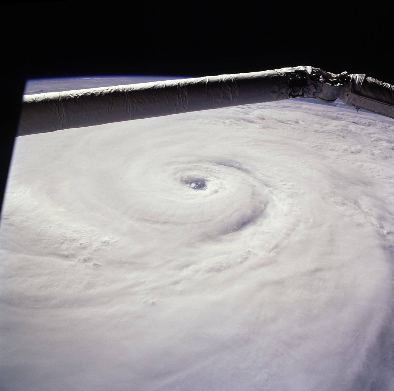
STS085-722-019 (15 August 1997) --- This view of supertyphoon Winnie was taken on August 15, 1997, as the storm swirled about 400 miles south of the southern tip of Japan. Sustained winds were 105 knots, gusting to 130 knots. This photo was shot on the Space Shuttle Discovery's twenty-third flight, as it glided by 170 miles above the sea surface on Orbit 123. On one pass the Discovery flew right over the eye; the commander commented that the eye was so large that it completely filled the window. The robotic arm crosses the top of the view. The cloud mass associated with Winnie covered thousands of square miles as this storm grew to supertyphoon status in the previous days, and raked across the Marianas Islands. A few days after this shot was taken, Winnie ploughed ashore on the coast of China, a bit south of the major metropolis of Shanghai, reportedly killing at least 100 people.
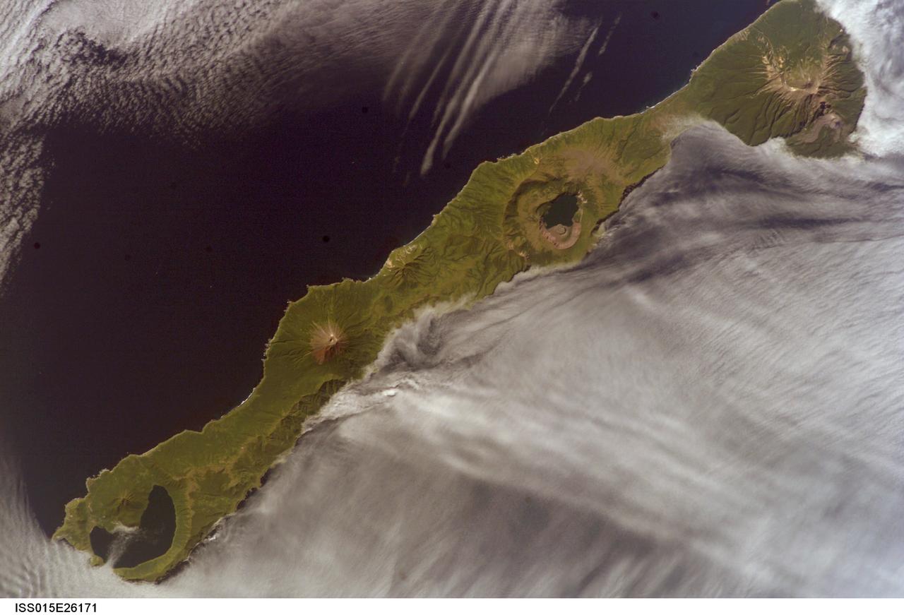
ISS015-E-26171 (1 Sept. 2007) --- Simushir Island, Kuril Archipelago, Russian Far East, is featured in this image photographed by an Expedition 15 crewmember on the International Space Station. Simushir is a deserted, 5-mile-wide volcanic island in the Kuril island chain, half way between northern Japan and the Kamchatka Peninsula of Russia. Four volcanoes - Milne, Prevo, Urataman and Zavaritski - have built cones that are high enough to rise above the altitude of green forest. The remaining remnant of Zavaritski volcano is a caldera -- a structure formed when a volcano collapses into its emptied magma chamber. A small lake fills the innermost of three nested calderas which make up Zavaritski Caldera. The larger caldera of Urataman Volcano is connected to the sea. A defunct Soviet naval base occupies the northern tip of the island next to this caldera. The islands and volcanoes of the Kuril chain are part of the Pacific Rim of Fire, marking the edge of the Pacific tectonic plate. Low stratus clouds approaching from the northwest (from the Sea of Okhotsk--top left) bank up against the northwest side of the island, making complex cloud patterns. A small finger of cloud can be seen entering the northernmost caldera (Urataman) at sea level. When this image was taken, the cloud layer had stopped at the northwest coast of the island, not flowing over even the low points of the island between the volcanoes. The cloud pattern suggests that the air mass flowed up and over the island, descending on the southeast side. This descending motion was enough--under stable atmospheric conditions--to warm up the atmosphere locally so that a cloud-free zone formed on the southeastern, lee side of the island.
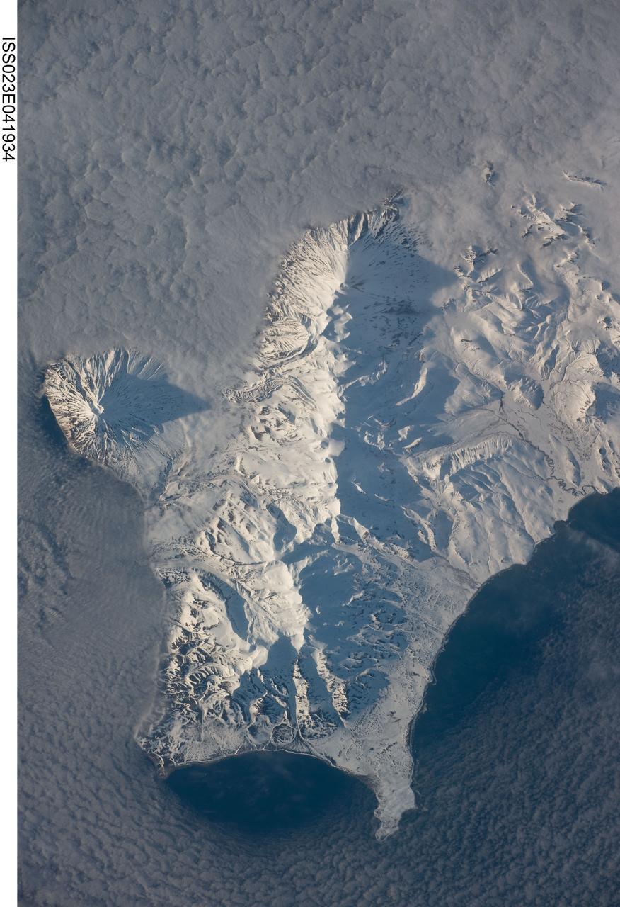
ISS023-E-041934 (12 May 2010) --- Southern Paramushir Island in the Kuril island chain in Russia is featured in this image photographed by an Expedition 23 crew member on the International Space Station. The Kuril island chain consists of a line of volcanoes, many of which have been historically active, that extends from the Kamchatka Peninsula to northern Japan. This line of island volcanoes is known to geologists as an island arc. Island arcs form along an active geologic boundary, typically marked by a deep undersea trench, between two tectonic plates with one being driven beneath the other (a process called subduction). Magma generated by this process feeds volcanoes ? and eventually, volcanic islands ? over the subduction boundary. Paramushir Island in the northern Kurils is an example of a large island built by several volcanoes over geologic time. This photograph shows the southern end of Paramushir Island after a snowfall. There are four major volcanic centers that form this part of the island. Fuss Peak (center left) is an isolated stratovolcano connected to the main island via an isthmus. The last recorded historical eruption of Fuss Peak was in 1854. The southern tip of the island is occupied by the Karpinsky Group of three volcanic centers. A minor eruption of ash following an earthquake occurred on this part of the island in 1952. The Lomonosov Group to the northeast (center) includes four cinder cones and a lava dome that produced several lava flows extending from the central ridge to the east, northeast, west, and southeast. There have been no recorded historical eruptions from the Lomonosov Group of volcanoes. The most recent volcanic activity (in 2008) occurred at the Chikurachki cone located along the northern coastline of the island at top center. The summit of this volcano (1816 meters above sea level) is the highest on Paramushir Island. Much of the Sea of Okhotsk visible in the image is covered with low clouds that typically form around the islands in the Kuril chain. The clouds are generated by moisture-laden air passing over the cool sea/ocean water and typically wrap around the volcanic islands.
Over the weekend of Oct. 5 and 6, Typhoon Phanfone's center made landfall just south of Tokyo and passed over the city before exiting back into the Northwestern Pacific Ocean. NASA's Aqua satellite captured a picture of the typhoon as Tokyo braced for its large eye. On its way to mainland Japan, Phanfone struck Kadena Air Base on the island of Okinawa. According to the website for U.S. Air Force Kadena Air Base (<a href="http://www.kadena.af.mil" rel="nofollow">www.kadena.af.mil</a>), "One Airman is confirmed deceased and two more are missing after they were washed out to sea from the northwest coast of Okinawa at about 3:45 p.m. Oct. 5. An Airman that was found by the Japanese Coast Guard and pulled from the sea was later pronounced dead at a local hospital. HH-60s from Kadena Air Base and Japanese Coast Guard are continuing to search for the remaining two Airmen. Rough seas are complicating rescue efforts." Typhoon Phanfone's large eye made landfall near the city of Hamamatsu on Oct. 5 around 8 a.m. local time and then tracked north before turning eastward into the Pacific Ocean north of Tokyo. The MODIS instrument known as the Moderate Resolution Imaging Spectroradiometer captures amazing pictures from its orbit aboard NASA's Aqua satellite. MODIS snapped a picture of Typhoon Phanfone approaching Japan on Oct. 5 at 12:55 a.m. EDT. At that time, the Typhoon had already passed north of Okinawa, and was just south of the large island of Kyushu. The MODIS image revealed a large eye with powerful bands of thunderstorms spiraling into the center. On Oct. 6 by 0900 UTC (5 a.m. EDT), Phanfone had weakened from a typhoon to a tropical storm back over open waters of the Northwestern Pacific Ocean. Maximum sustained winds were near 60 knots (69.0 mph/111.1 kph). Phanfone was located near 38.0 north longitude and 145.0 east latitude. That's about 201 nautical miles (271 miles/372 km) south-southeast of Misawa Air Base, Japan. Phanfone was moving to the northeast at 40 knots (46 mph/74 kph). Forecasters at the Joint Typhoon Warning Center (JTWC) using animated multispectral satellite imagery noted that Phanfone is being affected by strong wind shear. The wind shear has stretched the tropical storm out, and pushed the bulk of thunderstorms northeast of the center. In addition, Phanfone has transitioned into an extra-tropical storm, which means that its core transitioned from warm to cold. JTWC called for Phanfone to continue accelerating northeastward and weaken as an extra-tropical cyclone over water. <b><a href="http://www.nasa.gov/audience/formedia/features/MP_Photo_Guidelines.html" rel="nofollow">NASA image use policy.</a></b> <b><a href="http://www.nasa.gov/centers/goddard/home/index.html" rel="nofollow">NASA Goddard Space Flight Center</a></b> enables NASA’s mission through four scientific endeavors: Earth Science, Heliophysics, Solar System Exploration, and Astrophysics. Goddard plays a leading role in NASA’s accomplishments by contributing compelling scientific knowledge to advance the Agency’s mission. <b>Follow us on <a href="http://twitter.com/NASAGoddardPix" rel="nofollow">Twitter</a></b> <b>Like us on <a href="http://www.facebook.com/pages/Greenbelt-MD/NASA-Goddard/395013845897?ref=tsd" rel="nofollow">Facebook</a></b> <b>Find us on <a href="http://instagram.com/nasagoddard?vm=grid" rel="nofollow">Instagram</a></b>
A massive eruption of Montserrat’s Soufrière Hills Volcano covered large portions of the island in debris. The eruption was triggered by a collapse of Soufrière Hills’ summit lava dome on February 11, 2010. Pyroclastic flows raced down the northern flank of the volcano, leveling trees and destroying buildings in the village of Harris, which was abandoned after Soufrière Hills became active in 1995. The Montserrat Volcano Observatory reported that some flows, about 15 meters (49 feet) thick, reached the sea at Trant’s Bay. These flows extended the island’s coastline up to 650 meters (2,100 feet). These false-color satellite images show the southern half of Montserrat before and after the dome collapse. The top image shows Montserrat on February 21, 2010, just 10 days after the event. For comparison, the bottom image shows the same area on March 17, 2007. Red areas are vegetated, clouds are white, blue/black areas are ocean water, and gray areas are covered by flow deposits. Fresh deposits tend to be lighter than older deposits. On February 21, the drainages leading down from Soufrière Hills, including the White River Valley, the Tar River Valley, and the Belham River Valley, were filled with fresh debris. According to the Montserrat Volcano Observatory, pyroclastic flows reached the sea through Aymers Ghaut on January 18, 2010, and flows entered the sea near Plymouth on February 5, 2010. NASA Earth Observatory image by Robert Simmon, using data from the NASA/GSFC/METI/ERSDAC/JAROS, and U.S./Japan ASTER Science Team. Caption by Robert Simmon. To read more go to: <a href="http://earthobservatory.nasa.gov/IOTD/view.php?id=42792" rel="nofollow">earthobservatory.nasa.gov/IOTD/view.php?id=42792</a> <b><a href="http://www.nasa.gov/centers/goddard/home/index.html" rel="nofollow">NASA Goddard Space Flight Center</a></b> is home to the nation's largest organization of combined scientists, engineers and technologists that build spacecraft, instruments and new technology to study the Earth, the sun, our solar system, and the universe. <b>Follow us on <a href="http://twitter.com/NASA_GoddardPix" rel="nofollow">Twitter</a></b> <b>Join us on <a href="http://www.facebook.com/pages/Greenbelt-MD/NASA-Goddard/395013845897?ref=tsd" rel="nofollow">Facebook</a><b> </b></b>

ISS020-E-009011 (12 June 2009) --- Pohang, South Korea is featured in this image photographed by an Expedition 20 crew member on the International Space Station. The port city of Pohang is located on the eastern coastline of South Korea and provides access to the East Sea and Sea of Japan. While the Pohang area has been occupied by small fishing villages since approximately 1500 BC, development of an urban area only began in 1930 when harbor facilities were constructed. The Pohang Iron and Steel Company, or POSCO began construction of a large steel mill and associated facilities in 1968, with production of steel products commencing in 1972. The steel industry is still a major component of the city?s economic base, but recent efforts to lessen dependence on heavy industry has fostered new interest in environmentalism and culture within Pohang. The urban fabric of Pohang is strikingly divided by the Hyeongsan River. To the west of the river, residential and commercial development is characterized by small footprint, gray and white-roofed buildings connected by a dense road network. The eastern side of the river is dominated by industrial development associated with the POSCO steelyard. This development is characterized by large rectilinear factory and storage buildings with striking light blue and light red rooftops at center. Green vegetated hills and mountains border the urban area to the east, west, and south, with several vegetated hills located with the industrial development area. Numerous boat wakes are also visible to the east-northeast of the POSCO steelyard docks.
NASA image acquired September 24, 2012 City lights at night are a fairly reliable indicator of where people live. But this isn’t always the case, and the Korean Peninsula shows why. As of July 2012, South Korea’s population was estimated at roughly 49 million people, and North Korea’s population was estimated at about half that number. But where South Korea is gleaming with city lights, North Korea has hardly any lights at all—just a faint glimmer around Pyongyang. On September 24, 2012, the Visible Infrared Imaging Radiometer Suite (VIIRS) on the Suomi NPP satellite captured this nighttime view of the Korean Peninsula. This imagery is from the VIIRS “day-night band,” which detects light in a range of wavelengths from green to near-infrared and uses filtering techniques to observe signals such as gas flares, auroras, wildfires, city lights, and reflected moonlight. The wide-area image shows the Korean Peninsula, parts of China and Japan, the Yellow Sea, and the Sea of Japan. The white inset box encloses an area showing ship lights in the Yellow Sea. Many of the ships form a line, as if assembling along a watery border. Following the 1953 armistice ending the Korean War, per-capita income in South Korea rose to about 17 times the per-capital income level of North Korea, according to the U.S. Central Intelligence Agency. Worldwide, South Korea ranks 12th in electricity production, and 10th in electricity consumption, per 2011 estimates. North Korea ranks 71st in electricity production, and 73rd in electricity consumption, per 2009 estimates. NASA Earth Observatory image by Jesse Allen and Robert Simmon, using VIIRS Day-Night Band data from the Suomi National Polar-orbiting Partnership. Suomi NPP is the result of a partnership between NASA, the National Oceanic and Atmospheric Administration, and the Department of Defense. Caption by Michon Scott. Instrument: Suomi NPP - VIIRS Credit: <b><a href="http://www.earthobservatory.nasa.gov/" rel="nofollow"> NASA Earth Observatory</a></b> <b>Click here to view all of the <a href="http://earthobservatory.nasa.gov/Features/NightLights/" rel="nofollow"> Earth at Night 2012 images </a></b> <b>Click here to <a href="http://earthobservatory.nasa.gov/NaturalHazards/view.php?id=79796" rel="nofollow"> read more </a> about this image </b> <b><a href="http://www.nasa.gov/audience/formedia/features/MP_Photo_Guidelines.html" rel="nofollow">NASA image use policy.</a></b> <b><a href="http://www.nasa.gov/centers/goddard/home/index.html" rel="nofollow">NASA Goddard Space Flight Center</a></b> enables NASA’s mission through four scientific endeavors: Earth Science, Heliophysics, Solar System Exploration, and Astrophysics. Goddard plays a leading role in NASA’s accomplishments by contributing compelling scientific knowledge to advance the Agency’s mission. <b>Follow us on <a href="http://twitter.com/NASA_GoddardPix" rel="nofollow">Twitter</a></b> <b>Like us on <a href="http://www.facebook.com/pages/Greenbelt-MD/NASA-Goddard/395013845897?ref=tsd" rel="nofollow">Facebook</a></b> <b>Find us on <a href="http://instagram.com/nasagoddard?vm=grid" rel="nofollow">Instagram</a></b>
NASA image acquired September 24, 2012 City lights at night are a fairly reliable indicator of where people live. But this isn’t always the case, and the Korean Peninsula shows why. As of July 2012, South Korea’s population was estimated at roughly 49 million people, and North Korea’s population was estimated at about half that number. But where South Korea is gleaming with city lights, North Korea has hardly any lights at all—just a faint glimmer around Pyongyang. On September 24, 2012, the Visible Infrared Imaging Radiometer Suite (VIIRS) on the Suomi NPP satellite captured this nighttime view of the Korean Peninsula. This imagery is from the VIIRS “day-night band,” which detects light in a range of wavelengths from green to near-infrared and uses filtering techniques to observe signals such as gas flares, auroras, wildfires, city lights, and reflected moonlight. The wide-area image shows the Korean Peninsula, parts of China and Japan, the Yellow Sea, and the Sea of Japan. The white inset box encloses an area showing ship lights in the Yellow Sea. Many of the ships form a line, as if assembling along a watery border. Following the 1953 armistice ending the Korean War, per-capita income in South Korea rose to about 17 times the per-capital income level of North Korea, according to the U.S. Central Intelligence Agency. Worldwide, South Korea ranks 12th in electricity production, and 10th in electricity consumption, per 2011 estimates. North Korea ranks 71st in electricity production, and 73rd in electricity consumption, per 2009 estimates. NASA Earth Observatory image by Jesse Allen and Robert Simmon, using VIIRS Day-Night Band data from the Suomi National Polar-orbiting Partnership. Suomi NPP is the result of a partnership between NASA, the National Oceanic and Atmospheric Administration, and the Department of Defense. Caption by Michon Scott. Instrument: Suomi NPP - VIIRS Credit: <b><a href="http://www.earthobservatory.nasa.gov/" rel="nofollow"> NASA Earth Observatory</a></b> <b>Click here to view all of the <a href="http://earthobservatory.nasa.gov/Features/NightLights/" rel="nofollow"> Earth at Night 2012 images </a></b> <b>Click here to <a href="http://earthobservatory.nasa.gov/NaturalHazards/view.php?id=79796" rel="nofollow"> read more </a> about this image </b> <b><a href="http://www.nasa.gov/audience/formedia/features/MP_Photo_Guidelines.html" rel="nofollow">NASA image use policy.</a></b> <b><a href="http://www.nasa.gov/centers/goddard/home/index.html" rel="nofollow">NASA Goddard Space Flight Center</a></b> enables NASA’s mission through four scientific endeavors: Earth Science, Heliophysics, Solar System Exploration, and Astrophysics. Goddard plays a leading role in NASA’s accomplishments by contributing compelling scientific knowledge to advance the Agency’s mission. <b>Follow us on <a href="http://twitter.com/NASA_GoddardPix" rel="nofollow">Twitter</a></b> <b>Like us on <a href="http://www.facebook.com/pages/Greenbelt-MD/NASA-Goddard/395013845897?ref=tsd" rel="nofollow">Facebook</a></b> <b>Find us on <a href="http://instagram.com/nasagoddard?vm=grid" rel="nofollow">Instagram</a></b>
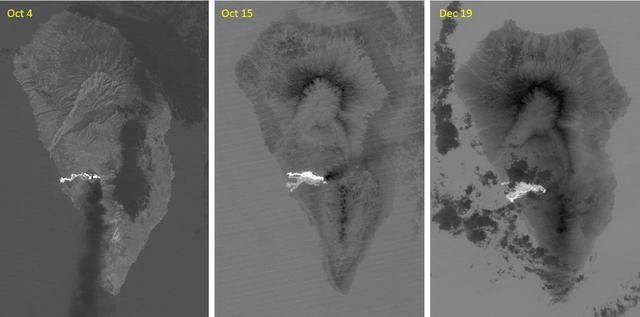
The major volcanic eruption of Cumbre Vieja volcano on La Palma, Canary Islands, began on September 21, 2021. For three months, lava poured out of the volcanic ridge, and flowed to the sea, engulfed 3000+ dwellings. The October 4 ASTER thermal infrared image shows the first flow reaching the coast. On October 15, a second flow followed to the north. By December 19, activity had stopped, and the flows are cooling. The images cover an area of 32.5 by 49.3 km, and are located at 28.6 degrees north, 17.9 degrees west. With its 14 spectral bands from the visible to the thermal infrared wavelength region and its high spatial resolution of about 50 to 300 feet (15 to 90 meters), ASTER images Earth to map and monitor the changing surface of our planet. ASTER is one of five Earth-observing instruments launched Dec. 18, 1999, on Terra. The instrument was built by Japan's Ministry of Economy, Trade and Industry. A joint U.S./Japan science team is responsible for validation and calibration of the instrument and data products. The broad spectral coverage and high spectral resolution of ASTER provides scientists in numerous disciplines with critical information for surface mapping and monitoring of dynamic conditions and temporal change. Example applications are monitoring glacial advances and retreats; monitoring potentially active volcanoes; identifying crop stress; determining cloud morphology and physical properties; wetlands evaluation; thermal pollution monitoring; coral reef degradation; surface temperature mapping of soils and geology; and measuring surface heat balance. https://photojournal.jpl.nasa.gov/catalog/PIA25085
![More than 70% of the world's hazelnuts come from Turkey, and about 60% come from the Eastern Black Sea region on the slopes of the Pontic mountain range, around the ancient coastal city of Giresun. The tradition of hazelnut farming goes back thousands of years. Presently, most of the hazelnut products are processed by women [BBC Travel]. The image was acquired August 15, 2024, covers an area of 35.7 by 36.2 km, and is located at 40.9 degrees north, 38.4 degrees east. With its 14 spectral bands from the visible to the thermal infrared wavelength region and its high spatial resolution of about 50 to 300 feet (15 to 90 meters), ASTER images Earth to map and monitor the changing surface of our planet. ASTER is one of five Earth-observing instruments launched Dec. 18, 1999, on Terra. The instrument was built by Japan's Ministry of Economy, Trade and Industry. A joint U.S./Japan science team is responsible for validation and calibration of the instrument and data products. The broad spectral coverage and high spectral resolution of ASTER provides scientists in numerous disciplines with critical information for surface mapping and monitoring of dynamic conditions and temporal change. Example applications are monitoring glacial advances and retreats; monitoring potentially active volcanoes; identifying crop stress; determining cloud morphology and physical properties; wetlands evaluation; thermal pollution monitoring; coral reef degradation; surface temperature mapping of soils and geology; and measuring surface heat balance. https://photojournal.jpl.nasa.gov/catalog/PIA26450](https://images-assets.nasa.gov/image/PIA26450/PIA26450~medium.jpg)
More than 70% of the world's hazelnuts come from Turkey, and about 60% come from the Eastern Black Sea region on the slopes of the Pontic mountain range, around the ancient coastal city of Giresun. The tradition of hazelnut farming goes back thousands of years. Presently, most of the hazelnut products are processed by women [BBC Travel]. The image was acquired August 15, 2024, covers an area of 35.7 by 36.2 km, and is located at 40.9 degrees north, 38.4 degrees east. With its 14 spectral bands from the visible to the thermal infrared wavelength region and its high spatial resolution of about 50 to 300 feet (15 to 90 meters), ASTER images Earth to map and monitor the changing surface of our planet. ASTER is one of five Earth-observing instruments launched Dec. 18, 1999, on Terra. The instrument was built by Japan's Ministry of Economy, Trade and Industry. A joint U.S./Japan science team is responsible for validation and calibration of the instrument and data products. The broad spectral coverage and high spectral resolution of ASTER provides scientists in numerous disciplines with critical information for surface mapping and monitoring of dynamic conditions and temporal change. Example applications are monitoring glacial advances and retreats; monitoring potentially active volcanoes; identifying crop stress; determining cloud morphology and physical properties; wetlands evaluation; thermal pollution monitoring; coral reef degradation; surface temperature mapping of soils and geology; and measuring surface heat balance. https://photojournal.jpl.nasa.gov/catalog/PIA26450

NASA satellite imagery from July 10 revealed a very clear and cloudless eye in the Northwestern Pacific’s Typhoon Soulik as it moves toward a landfall in China by the end of the week. The Moderate Resolution Imaging Spectroradiometer (MODIS) instrument aboard NASA’s Terra satellite captured a visible image of Typhoon Soulik and its clear eye on July 10, 2013 at 2:10 UTC as it continues to move through the northwestern Pacific Ocean. Soulik’s round eye is about 25 nautical miles (28.7 miles/46.3 km) wide. Typhoon Soulik’s maximum sustained winds have increased dramatically over the last 24 hours and at 1500 UTC (11 a.m. EDT) on July 10, were blowing at 120 knots (138 mph/222 kph). According to the Joint Typhoon Warning Center, Soulik’s powerful winds are creating seas over 40 feet (12.2 meters) high in the northwestern Pacific Ocean. Soulik’s center was near 21.9 north latitude and 132.9 east longitude, about 420 nautical miles (483.3 miles/777.7 km) southeast of Kadena Air Base, Japan. Soulik is moving to the west-northwest at 13 knots (15 mph/24 kph). Soulik is tracking west-northwest along the southern edge of a subtropical ridge (elongated area) of high pressure. The ridge of high pressure stretches from east to west and westward over the Ryukyu Islands and into the East China Sea along about 30 north latitude. Soulik is still expected to make a landfall in southeastern China on July 12 or 13 after passing north of Taiwan. Text credit: Rob Gutro More info about the storm: <a href="http://1.usa.gov/12mvQcC" rel="nofollow">1.usa.gov/12mvQcC</a> <b><a href="http://www.nasa.gov/audience/formedia/features/MP_Photo_Guidelines.html" rel="nofollow">NASA image use policy.</a></b> <b><a href="http://www.nasa.gov/centers/goddard/home/index.html" rel="nofollow">NASA Goddard Space Flight Center</a></b> enables NASA’s mission through four scientific endeavors: Earth Science, Heliophysics, Solar System Exploration, and Astrophysics. Goddard plays a leading role in NASA’s accomplishments by contributing compelling scientific knowledge to advance the Agency’s mission. <b>Follow us on <a href="http://twitter.com/NASA_GoddardPix" rel="nofollow">Twitter</a></b> <b>Like us on <a href="http://www.facebook.com/pages/Greenbelt-MD/NASA-Goddard/395013845897?ref=tsd" rel="nofollow">Facebook</a></b> <b>Find us on <a href="http://instagram.com/nasagoddard?vm=grid" rel="nofollow">Instagram</a></b>
Sochi, Russia Winter Olympic Sites (Coastal Cluster) The Black Sea resort of Sochi, Russia, is the warmest city ever to host the Winter Olympic Games, which open on Feb. 7, 2014, and run through Feb. 23. This north-looking image, acquired on Jan. 4, 2014, by the Advanced Spaceborne Thermal Emission and Reflection Radiometer (ASTER) instrument on NASA's Terra spacecraft, shows the Sochi Olympic Park Coastal Cluster -- the circular area on the shoreline in the bottom center of the image -- which was built for Olympic indoor sports. Even curling has its own arena alongside multiple arenas for hockey and skating. The Olympic alpine events will take place at the Mountain Cluster, located in a snow-capped valley at the top right of the image. Sochi itself, a city of about 400,000, is not visible in the picture. It's farther west (left) along the coast, past the airport at bottom left. In the image, red indicates vegetation, white is snow, buildings are gray and the ocean is dark blue. The area imaged is about 15 miles (24 kilometers) from west to east (left to right) at the coastline and 25 miles (41 kilometers) from front to back. Height is exaggerated 1.5 times. The image was created from the ASTER visible and near-infrared bands, draped over ASTER-derived digital elevation data. With its 14 spectral bands from the visible to the thermal infrared wavelength region and its high spatial resolution of 15 to 90 meters (about 50 to 300 feet), ASTER images Earth to map and monitor the changing surface of our planet. ASTER is one of five Earth-observing instruments launched Dec. 18, 1999, on Terra. The instrument was built by Japan's Ministry of Economy, Trade and Industry. A joint U.S./Japan science team is responsible for validation and calibration of the instrument and data products. The broad spectral coverage and high spectral resolution of ASTER provides scientists in numerous disciplines with critical information for surface mapping and monitoring of dynamic conditions and temporal change. Example applications are: monitoring glacial advances and retreats; monitoring potentially active volcanoes; identifying crop stress; determining cloud morphology and physical properties; wetlands evaluation; thermal pollution monitoring; coral reef degradation; surface temperature mapping of soils and geology; and measuring surface heat balance. The U.S. science team is located at NASA's Jet Propulsion Laboratory, Pasadena, Calif. The Terra mission is part of NASA's Science Mission Directorate, Washington, D.C. More information about ASTER is available at <a href="http://asterweb.jpl.nasa.gov/" rel="nofollow">asterweb.jpl.nasa.gov/</a>. Image credit: NASA/GSFC/METI/ERSDAC/JAROS, and U.S./Japan ASTER Science Team <b><a href="http://www.nasa.gov/audience/formedia/features/MP_Photo_Guidelines.html" rel="nofollow">NASA image use policy.</a></b> <b><a href="http://www.nasa.gov/centers/goddard/home/index.html" rel="nofollow">NASA Goddard Space Flight Center</a></b> enables NASA’s mission through four scientific endeavors: Earth Science, Heliophysics, Solar System Exploration, and Astrophysics. Goddard plays a leading role in NASA’s accomplishments by contributing compelling scientific knowledge to advance the Agency’s mission. <b>Follow us on <a href="http://twitter.com/NASAGoddardPix" rel="nofollow">Twitter</a></b> <b>Like us on <a href="http://www.facebook.com/pages/Greenbelt-MD/NASA-Goddard/395013845897?ref=tsd" rel="nofollow">Facebook</a></b> <b>Find us on <a href="http://instagram.com/nasagoddard?vm=grid" rel="nofollow">Instagram</a></b>
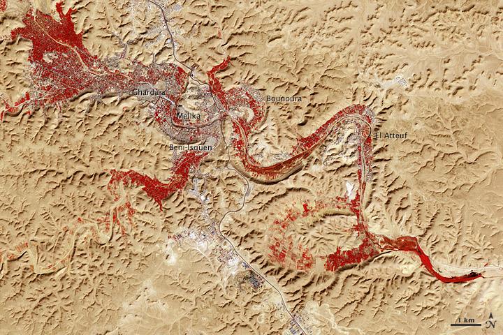
NASA image acquired Feb. 9, 2011 Less than 5 percent of Algeria’s land surface is suitable for growing crops, and most precipitation falls on the Atlas Mountains along the coast. Inland, dust-laden winds blow over rocky plains and sand seas. However, in north central Algeria—off the tip of Grand Erg Occidental and about 450 kilometers (280 miles) south of Algiers—lies a serpentine stretch of vegetation. It is the M’zab Valley, filled with palm groves and dotted with centuries-old settlements. The Advanced Spaceborne Thermal Emission and Reflection Radiometer (ASTER) on NASA’s Terra satellite captured this image of M’zab Valley on February 9, 2011. ASTER combines infrared, red, and green wavelengths of light. Bare rock ranges in color from beige to peach. Buildings and paved surfaces appear gray. Vegetation is red, and brighter shades of red indicate more robust vegetation. This oasis results from water that is otherwise in short supply in the Sahara Desert, thanks to the valley’s approximately 3,000 wells. Chemical analysis of Algerian aquifers, as well studies of topography in Algeria and Tunisia, suggest this region experienced a cooler climate in the late Pleistocene, and potentially heavy monsoon rains earlier in the Holocene. The M’zab region shows evidence of meandering rivers and pinnate drainage patterns. The vegetation lining M’zab Valley highlights this old river valley’s contours. Cool summer temperatures and monsoon rains had long since retreated from the region by eleventh century, but this valley nevertheless supported the establishment of multiple fortified settlements, or ksours. Between 1012 A.D. and 1350 A.D., locals established the ksours of El-Atteuf, Bounoura, Melika, Ghardaïa, and Beni-Isguen. Collectively these cities are now a United Nations Educational, Scientific, and Cultural Organization (UNESCO) World Heritage site. NASA Earth Observatory image by Robert Simmon and Jesse Allen, using data from the GSFC/METI/ERSDAC/JAROS, and U.S./Japan ASTER Science Team. Caption by Michon Scott. Instrument: Terra - ASTER <b>To download the full high res file go <a href="http://earthobservatory.nasa.gov/IOTD/view.php?id=51296" rel="nofollow"> here</a></b>
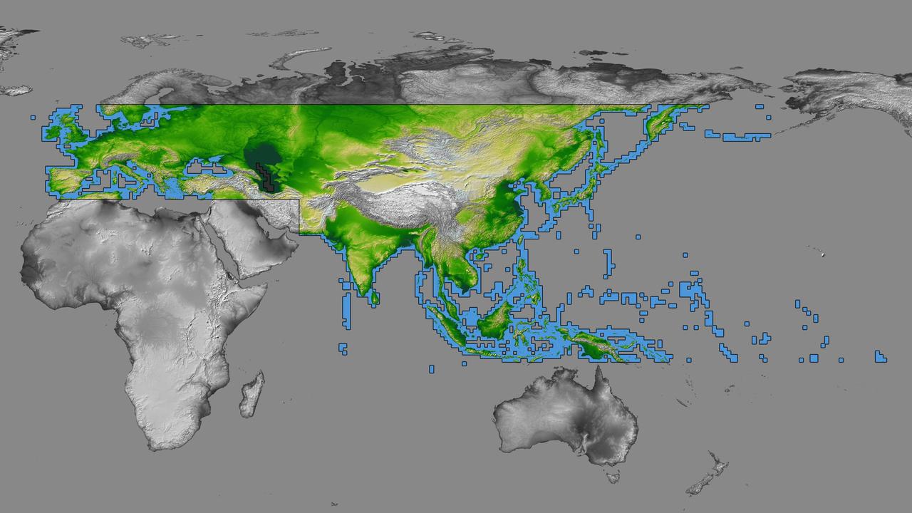
inal Caption Released with Image: The colored regions of this map show the extent of digital elevation data recently released by the Shuttle Radar Topography Mission (SRTM). This release includes data for most of Europe and Asia plus numerous islands in the Indian and Pacific Oceans. SRTM flew on board the Space Shuttle Endeavour in February 2000 and used an interferometric radar system to map the topography of Earth's landmass between latitudes 56 degrees south and 60 degrees north. The data were processed into geographic "tiles," each of which represents one by one degree of latitude and longitude. A degree of latitude measures 111 kilometers (69 miles) north-south, and a degree of longitude measures 111 kilometers or less east-west, decreasing away from the equator. The data are being released to the public on a continent-by-continent basis. This Eurasia segment includes 5,940 tiles, more than a third of the total data set. Previous releases covered North America and South America. Forthcoming releases will include Africa-Arabia and Australia plus an "Islands" release for those islands not included in the continental releases. Together these data releases constitute the world's first high-resolution, near-global elevation model. The resolution of the publicly released data is three arcseconds (1/1,200 of a degree of latitude and longitude), which is about 90 meters (295 feet). European coverage in the current data release stretches eastward from the British Isles and the Iberian Peninsula in the west, across the Alps and Carpathian Mountains, as well as the Northern European Plain, to the Ural and Caucasus Mountains bordering Asia. The Asian coverage includes a great diversity of landforms, including the Tibetan Plateau, Tarin Basin, Mongolian Plateau, and the mountains surrounding Lake Baikal, the world's deepest lake. Mt. Everest in the Himalayas, at 8,848 meters (29,029 feet) is the world's highest mountain. From India's Deccan Plateau, to Southeast Asia, coastal China, and Korea, various landforms place constraints upon land use planning for a great population. Volcanoes in the East Indies, the Philippines, Japan, and the Kamchatka Peninsula form the western part of the "Ring of Fire" around the Pacific Ocean. Many of these regions were previously very poorly mapped due to persistent cloud cover or the inaccessibility of the terrain. Digital elevation data, such as provided by SRTM, are particularly in high demand by scientists studying earthquakes, volcanism, and erosion patterns for use in mapping and modeling hazards to human habitation. But the shape of Earth's surface affects nearly every natural process and human endeavor that occurs there, so elevation data are used in a wide range of applications. In this index map color-coding is directly related to topographic height, with green at the lower elevations, rising through yellow and tan, to white at the highest elevations. The large, very dark green feature in western Asia is the Caspian Sea, which is below sea level. Blue areas on the map represent water within the mapped tiles, each of which includes shorelines or islands. http://photojournal.jpl.nasa.gov/catalog/PIA03398
The Kuril Islands are a string of volcanically-formed islands that stretch between Russia and Japan, separating the North Pacific Ocean from the Sea of Okhotsk. Subject to the cold, moist breezes from the North Atlantic, and the frigid air from Siberia, the climate is severe, with frequent storms, and ever-present winds, which often reach hurricane strength. Cloudy, windy conditions are common. On June 1, 2015 the Moderate Resolution Imaging Spectroradiometer (MODIS) aboard NASA’s Aqua satellite captured this true-color image as it passed over the Kuril Islands. Clouds curl into the center of a storm system, bringing strong winds to the region. As the winds scrape over the tall volcanic peaks of the Kuril Islands, they become turbulent air behind the islands. The turbulence disturbs the cloudbank, etching its passage into a striking pattern that can be seen from space. This particular pattern is called “ship-waved-shaped wave clouds”, because the pattern can be likened to that formed behind a ship cutting through a smooth ocean. On the windward side of the Kuril Islands, the cloud bank is generally smooth, with streaks that are lined up parallel to the movement of the wind, blowing from the west and towards the east. Behind the tall volcanic peaks of the islands, V’s fan out on the leeward side, illustrating the flow of the turbulent air. Image Credit: Jeff Schmaltz, MODIS Land Rapid Response Team, NASA GSFC <b><a href="http://www.nasa.gov/audience/formedia/features/MP_Photo_Guidelines.html" rel="nofollow">NASA image use policy.</a></b> <b><a href="http://www.nasa.gov/centers/goddard/home/index.html" rel="nofollow">NASA Goddard Space Flight Center</a></b> enables NASA’s mission through four scientific endeavors: Earth Science, Heliophysics, Solar System Exploration, and Astrophysics. Goddard plays a leading role in NASA’s accomplishments by contributing compelling scientific knowledge to advance the Agency’s mission. <b>Follow us on <a href="http://twitter.com/NASAGoddardPix" rel="nofollow">Twitter</a></b> <b>Like us on <a href="http://www.facebook.com/pages/Greenbelt-MD/NASA-Goddard/395013845897?ref=tsd" rel="nofollow">Facebook</a></b> <b>Find us on <a href="http://instagrid.me/nasagoddard/?vm=grid" rel="nofollow">Instagram</a></b>

Typhoon Chan-Hom's eye was visible from space when NASA's Aqua satellite passed overhead early on July 8, 2015. The MODIS instrument, known as the Moderate Resolution Imaging Spectrometer, flies aboard NASA's Aqua satellite. When Aqua passed over Typhoon Chan-Hom on July 8 at 04:25 UTC (12:25 a.m. EDT), MODIS captured a visible-light image of the storm that clearly showed its eye. The MODIS image also a ring of powerful thunderstorms surrounding the eye of the storm, and the bulk of thunderstorms wrapping around the system from west to east, along the southern side. At 0900 UTC (5 a.m. EDT), Typhoon Chan-Hom's maximum sustained winds were near 85 knots (97.8 mph/157.4 kph). Tropical-storm-force winds extended 145 nautical miles (166.9 miles/268.5 km) from the center, making the storm almost 300 nautical miles (345 miles/555 km) in diameter. Typhoon-force winds extended out to 35 nautical miles (40 miles/64.8 km) from the center. Chan-Hom's eye was centered near 20.5 North latitude and 132.7 East longitude, about 450 nautical miles (517.9 miles/833.4 km) southeast of Kadena Air Base, Iwo To, Japan. Chan-Hom was moving to the northwest at 11 knots (12.6 mph/20.3 kph). The typhoon was generating very rough seas with wave heights to 28 feet (8.5 meters). The Joint Typhoon Warning Center expects Chan-Hom to continue tracking northwestward over the next three days under the steering influence of a sub-tropical ridge (elongated area of high pressure). Chan-Hom is expected to intensify steadily peaking at 120 knots (138.1 mph/222.2 kph) on July 10. The JTWC forecast predicts that Chan-Hom will make landfall near Wenzhou, Zhejiang, China and begin decaying due to land interaction. For updated warnings and watches from China's National Meteorological Centre, visit: <a href="http://www.cma.gov.cn/en/WeatherWarnings/" rel="nofollow">www.cma.gov.cn/en/WeatherWarnings/</a>. Credit: NASA/GSFC/Jeff Schmaltz/MODIS Land Rapid Response Team b><a href="http://www.nasa.gov/audience/formedia/features/MP_Photo_Guidelines.html" rel="nofollow">NASA image use policy.</a> <b><a href="http://www.nasa.gov/centers/goddard/home/index.html" rel="nofollow">NASA Goddard Space Flight Center</a></b> enables NASA’s mission through four scientific endeavors: Earth Science, Heliophysics, Solar System Exploration, and Astrophysics. Goddard plays a leading role in NASA’s accomplishments by contributing compelling scientific knowledge to advance the Agency’s mission. <b>Follow us on <a href="http://twitter.com/NASAGoddardPix" rel="nofollow">Twitter</a></b> <b>Like us on <a href="http://www.facebook.com/pages/Greenbelt-MD/NASA-Goddard/395013845897?ref=tsd" rel="nofollow">Facebook</a></b> <b>Find us on <a href="http://instagrid.me/nasagoddard/?vm=grid" rel="nofollow">Instagram</a></b>