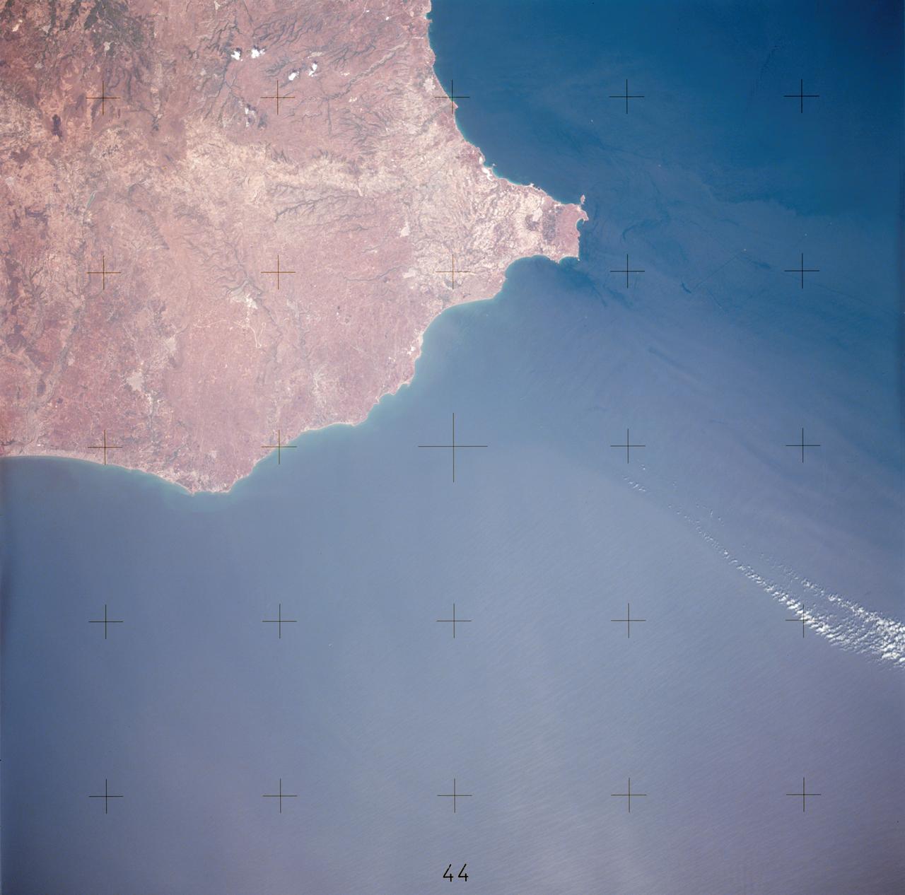
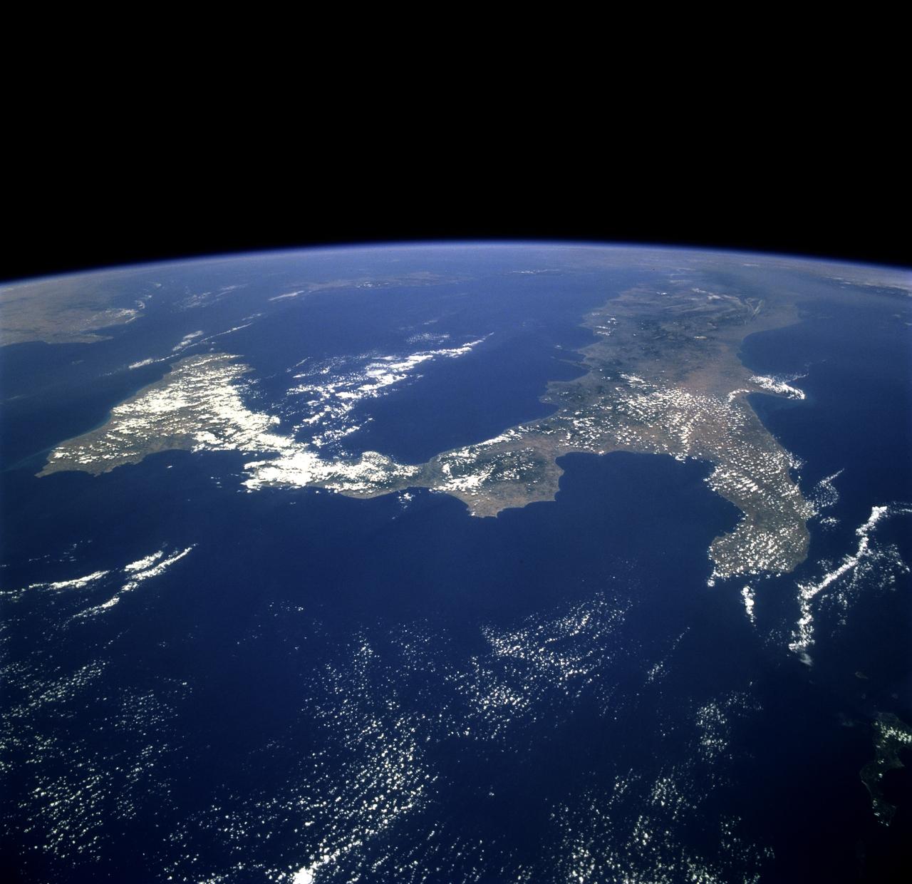
AST-17-1378 (20 July 1975) --- A near vertical view of the most southerly portion of the Island of Sicily in the Mediterranean Sea, as photographed from the Apollo spacecraft in Earth orbit during the joint U.S.-USSR Apollo-Soyuz Test Project mission. This view includes the towns of Gala, Pachino, Avela and Pozzalo. The photograph was taken at an altitude of 228 kilometers (141 statute miles) with a 70mm Hasselblad camera using high-definition aerial Ektachrome SO-242 type film.
STS058-95-028 (18 Oct-1Nov 1993) --- Lake Urmia (Orumiyeh) in the high desert plateau of northwest Iran dominates the center of this northeast-looking view. The left edge of the view cuts Lake Van in eastern Turkey. The Caucasus Mountains in war-torn Georgia appear just beyond. Mount Ararat, of biblical fame, is a major peak north of Lake Van. The Caspian Sea, an international body of water, stretches across the top right of the view. Countries bordering the Caspian are Iran in the south, Kazakhstan in the west, and Russia and Azerbaijan in the west.
SL4-140-4110 (January 1974) --- View of the USSR, Siberia area from Skylab 4. Other areas seen are Ozero, Kanka, Ussiriysk, the Sea of Japan and Kavalerovo (45.5N, 135.5E). Photo credit: NASA
AST-16-1268 (20 July 1975) --- A near vertical view of a portion of the Mediterranean coast of Turkey and Syria, as photographed from the Apollo spacecraft in Earth orbit during the joint U.S-USSR Apollo-Soyuz Test Project mission. This view covers the Levant Coast north of Beirut, showing the cities of Aleppo, Hamah, Homs and Latakia. The Levantine rift bends to the northeast. This picture was taken with a 70mm Hasselblad camera using high-definition aerial Ektachrome SO-242 type film. The altitude of the spacecraft was 225 kilometers (140 statute miles) when this photograph was taken.
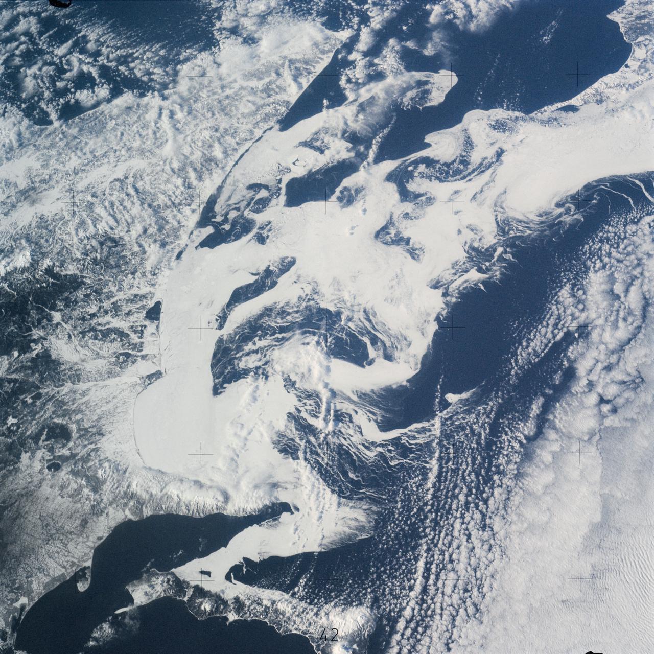
SL4-141-4340 (20 Jan. 1974) --- An oblique view of the southern part of the Sea of Okhotsk, north of Japan, as photographed from the Skylab space station in Earth orbit by one of the Skylab 4 crewmen. The camera used was a hand-held 70mm Hasselblad, and SO-368 medium-speed Ektachrome. NORTH IS AT THE TOP WHEN THE PICTURE IS HELD WITH THE LARGEST LAND MASS AT THE BOTTOM. Most of the land area is Hokkaido Island, Japan. The southern tip of Sakhalin Island (Soviet Union) is in the northwest corner. This photograph was taken to aid in the study of the formation of sea ice. Comparison of these photographs will be made with observations made during a joint USSR-U.S. experiment in the Bering Sea a year earlier. Observations in the Sea of Okhotsk are of interest because the ice has a morphology similar to that of the Bering Sea. Photo credit: NASA
AS07-04-1609 (21 Oct. 1968) --- Woodlark Island in the Solomon Sea, east of New Guinea and northeast of Australia, as seen from the Apollo 7 spacecraft during its 158th revolution of Earth. Photographed from an altitude of 140 nautical miles, at ground elapsed time of 251 hours and 21 minutes.
AS07-07-1774 (15 Oct. 1968) --- Red Sea coastal area of Saudi Arabia as seen from the Apollo 7 spacecraft during its 58th revolution of Earth. This picture shows extent of coral reefs in the Red Sea. Photographed from an altitude of 88 nautical miles, at ground elapsed time of 91 hours and 17 minutes.
STS059-L22-140 (9-20 April 1994) --- View northeastward across Uzbekastan to the partly-ice-covered Aral Sea and Kazakhstan. The irrigated fan-delta of the Amu Darya extends from the right side of the photograph to end in extensive salt flats at the south end of the sea. The Aral was the fourth-largest inland sea or lake in the world, until diversion and over-use of the river water for irrigation led, in this arid climate, to the sea's decline. Linhof camera.
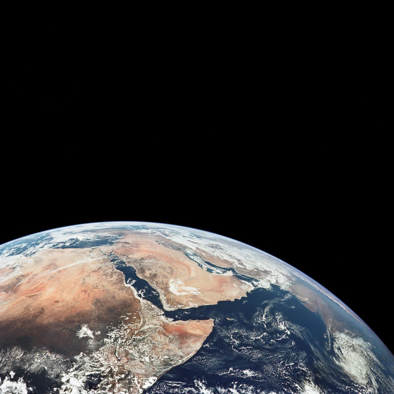
AS17-148-22718 (7-19 Dec. 1972) --- This excellent view of Saudi Arabia and the north eastern portion of the African continent was photographed by the Apollo 17 astronauts with a hand-held camera on their trans-lunar coast toward man's last lunar visit. Egypt, Sudan, Ethiopia are some of the African nations are visible. Iran, Iraq, Jordan are not so clearly visible because of cloud cover and their particular location in the picture. India is dimly visible at right of frame. The Red Sea is seen entirely in this one single frame, a rare occurrence in Apollo photography or any photography taken from manned spacecraft. The Gulf of Suez, the Dead Sea, Gulf of Aden, Persian Gulf and Gulf of Oman are also visible. This frame is one of 169 frames on film magazine NN carried aboard Apollo 17, all of which are SO368 (color) film. A 250mm lens on a 70mm Hasselblad camera recorded the image, one of 92 taken during the trans-lunar coast. Note AS17-148-22727 (also magazine NN) for an excellent full Earth picture showing the entire African continent.
S66-45749 (18 July 1966) --- Straits of Gibraltar, Mediterranean Sea, Spain in background, Algeria and Morocco in foreground as seen from Gemini-10 spacecraft. Photo credit: NASA

SL3-40-077 (July-September 1973) --- A vertical view of the Mediterranean coastal area of southeastern France as photographed from Earth orbit by one of the six lenses of the Itek-furnished S190-A Multispectral Photographic Facility Experiment aboard the Skylab space station. This view of the coast extends from the eastern outskirts of Marseilles easterly to Cannes, and includes the city of Toulon. The S190-A experiment is part of the Skylab Earth Resources Experiments Package. Federal agencies participating with NASA on the EREP project are the Departments of Agriculture, Commerce, Interior, the Environmental Protection Agency and the Corps of Engineers. All EREP photography is available to the public through the Department of Interior?s Earth Resources Observations Systems Data Center, Sioux Falls, South Dakota, 57198. Photo credit: NASA
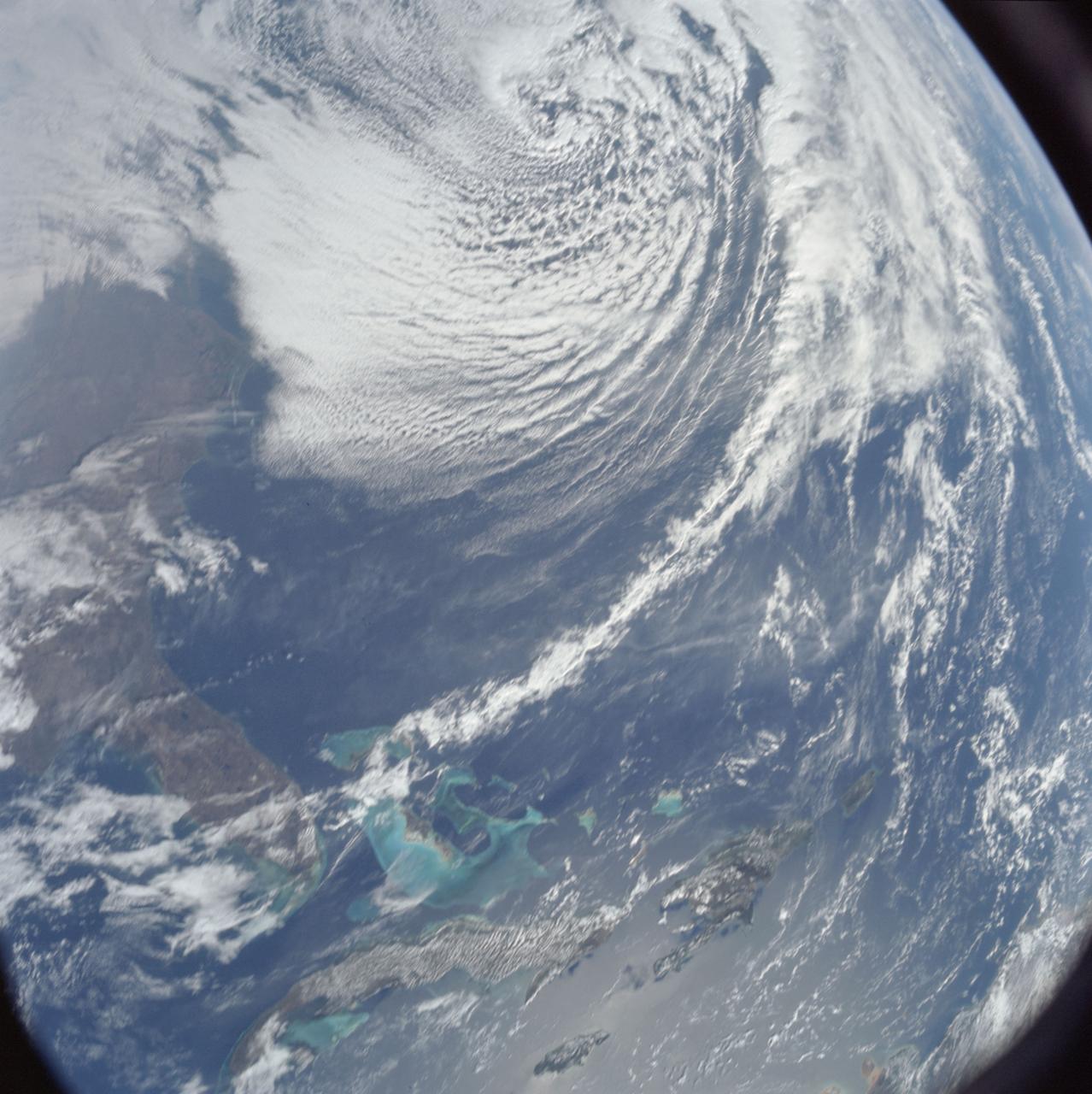
AS08-16-2581 (21-27 Dec. 1968) --- This photograph of Earth was taken from the Apollo 8 spacecraft while it was in Earth orbit. Most of the southeastern United States and the Caribbean Sea area, the U.S. coastline from Chesapeake Bay to the Florida Peninsula can be seen. The Bahamas and the islands of Cuba, Jamaica, Hispaniola and Puerto Rico extend across the Caribbean, the light blue of the shallow Bahama banks contrasting sharply with the darker hue of the deeper water, especially in the Tongue of the Ocean area.

SL3-33-156 (July-September 1973) --- A near vertical view of the Florence, Italy area as photographed from Earth orbit by one of the Itek-furnished S190-A Multispectral Photographic Facility Experiment aboard the Skylab space station. The view extends from the Ligurian Sea, an extension of the Mediterranean Sea, across the Apennine Mountains to the Po River Valley. Florence (Firenze) is near the center of the land mass. The mouth of the Arno River is at the center of the coastline. The city of Leghorn (Livorno) is on the coast just south of the Arno River. This picture was taken with type 2443 infrared color film. The S190-A experiment is part of the Skylab Earth Resources Experiments Package. Federal agencies participating with NASA on the EREP project are the Department of Agriculture, Commerce, Interior, the Environmental Protection Agency and the Corps of Engineers. All EREP photography is available to the public through the Department of Interior?s Earth Resources Observations Systems Data Center, Sioux Falls, South Dakota, 57198. Photo credit: NASA
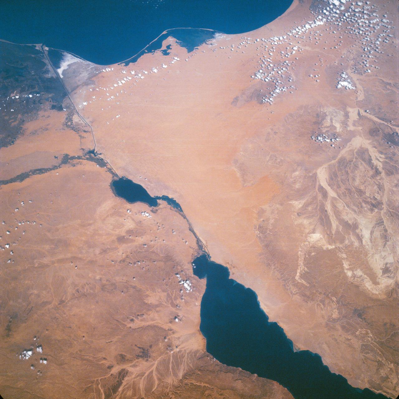
Suez Canal, Gulf of Suez, Sinai Peninsula, United Arab Republic (Egypt), Mediterranean Sea, as seen from the Apollo 7 spacecraft during its 13th revolution of the earth. Photographed from an altitude of 126 nautical miles, at ground elapsed time of 19 hours and 42 minutes.
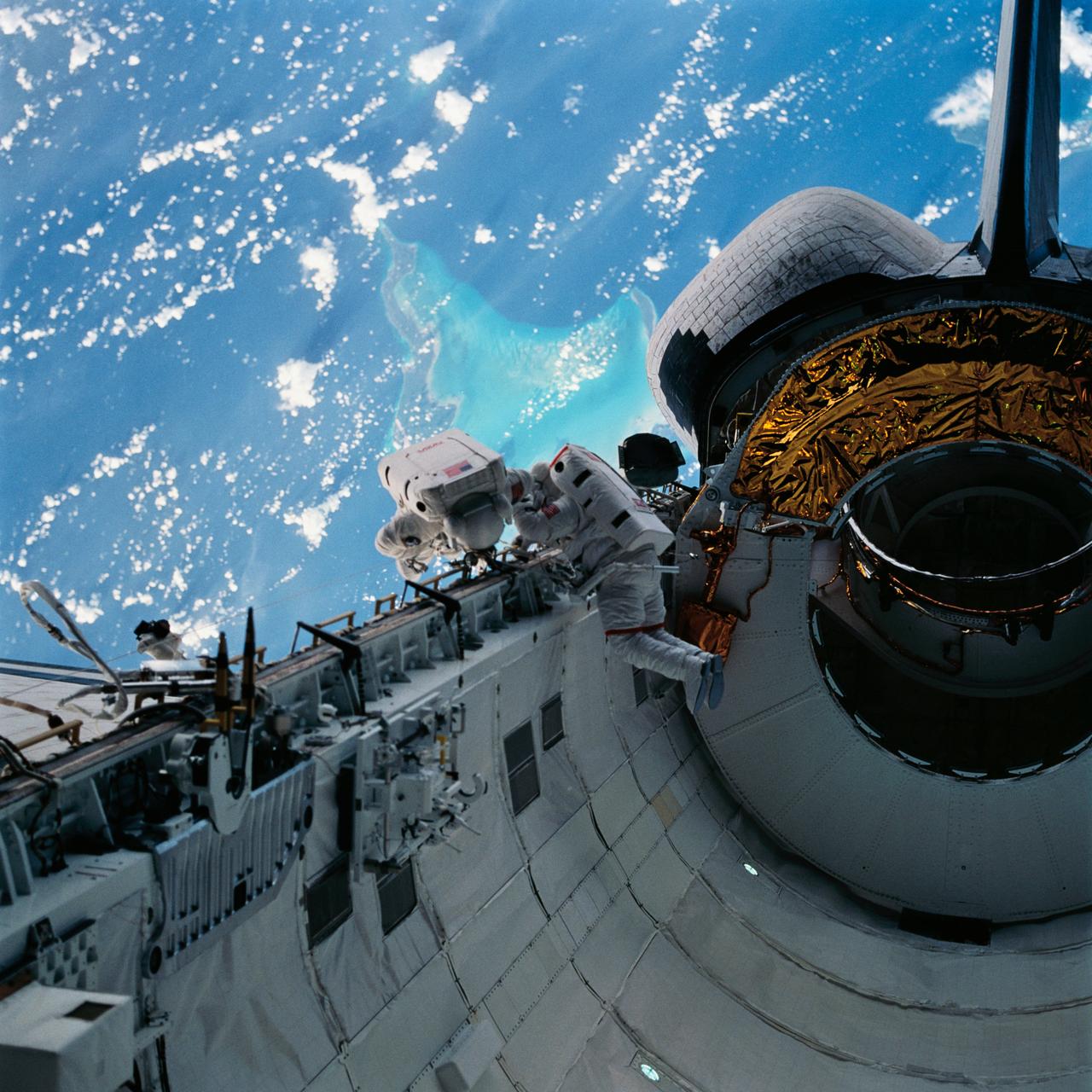
With the Caribbean Sea and part of the Bahama Islands chain as a backdrop, two STS-51 crewmembers evaluate procedures and gear to be used on the upcoming Hubble Space Telescope (HST)-servicing mission. Sharing the lengthy extravehicular activity in and around Discovery's cargo bay were astronauts James H. Newman (left), and Carl E. Walz, mission specialists.
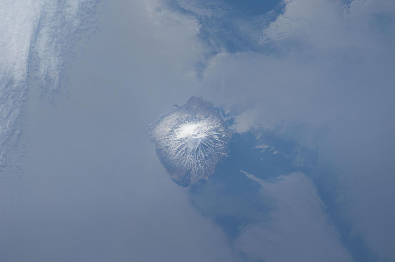
ISS031-E-041959 (18 May 2012) --- Alaid Volcano in the Kuril Islands of the Russian Federation is featured in this image photographed by an Expedition 31 crew member on the International Space Station. The Kurils chain extends from the Kamchatka Peninsula to the islands of Japan, and contains numerous active volcanoes along its length. Alaid is the highest (2,339 meters above sea level) volcano in the Kuril chain, as well as being the northernmost. The textbook conic morphology of this stratovolcano is marred only by the summit crater, which is breached to the south (center) and highlighted by snow cover. The volcano rises 3,000 meters directly from the floor of the Sea of Okhotsk, with the uppermost part of the volcanic edifice exposed as an island. Much of the sea surface surrounding the volcano has a silver-gray appearance. This mirror-like appearance is due to sunglint, where light reflects off the sea surface and is scattered directly towards the observer onboard the space station. Sunglint is largely absent from a zone directly to the west of the volcano, most likely due to surface wind or water current patterns that change the roughness?and light scattering properties?of the water surface in this area. Volcanoes in the Kurils, and similar island arcs in the Pacific ?ring of fire?, are fed by magma generated along the boundary between two tectonic plates, where one plate is being driven beneath the other (a process known as subduction). Alaid Volcano has been historically active with the most recent confirmed explosive activity occurring in 1996.
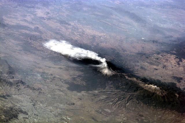
ISS01-E-5316 (23 January 2001) -- Popocatépetl, or Popo, the active volcano located about 70 kilometers southeast of Mexico City, sends a plume south on January 23, 2001. The Expedition One crew onboard the International Space Station (ISS) observed and recorded this image with a digital still camera as it orbited to the northeast of the volcano. Popo has been frequently active for six years. On this day, the eruption plume reportedly rose to more than 9 kilometers above sea level (for reference, Popo's summit elevation is 5426 meters). Note the smaller ash plume below the main plume. The perspective from the ISS allowed the crew members this unique three dimensional view. Popo is situated between two large population centers: Mexico City (more than 18 million people, and just out of this image at right) and Puebla (about 1.2 million people), partially visible at lower left.
SL3-27-224 (July-September 1973) --- A vertical view of the western portion of the Republic of Panama on the Isthmus of Panama as photographed from Earth orbit by one of the six lenses of the Itek-furnished S190-A Multispectral Photographic Facility Experiment aboard the Skylab space station. This picture was taken with 2443 infrared color film. The large, clear body of water on the north side of the isthmus is Golfo de los Mosquitos, an extension of the Caribbean Sea. The large, partly cloud-covered body of water on the south side of the isthmus is Golfo de Chiriqui, an extension of the Pacific Ocean. Federal agencies participating with NASA on the EREP project are the Department of Agriculture, Commerce, Interior, the Environmental Protection Agency and the Corps of Engineers. All EREP photography is available to the public through the Department of Interior?s Earth Resources Observation Systems Data Center, Sioux Falls, South Dakota, 57198. Photo credit: NASA
STS078-751-012 (20 June-7 July 1996) --- The international crew of the Life and Microgravity Spacelab (LMS-1) mission onboard the Space Shuttle Columbia photographed this oblique view of the "toe" of Italy and the island of Sicily. Southern Italy is known as the Mezzogiorno because of the intensity of sunshine there at midday (Mezzogiorno is the Italian term for "midday" or "noon"). Mezzogiorno is a mainland subregion consisting of the modern southern Italian regions of Abruzzi, Molise, Campania, Puglia, Basilicata, and Calabria and an insular subregion composed of Sicily and Sardinia. Southern Italy is dominated by the Apennine Range, seen in the photo on the west side, and up to one-half of the land is too steep for any form of cultivation. Coastal plains are generally narrow and poorly drained and are limited to the environs of the cities of Naples and Salerno, Foggia, and Taranto. Chief crops in this region include wheat, olives, grapes, peaches, apricots, pears, and various vegetables. Iron, steel, machine tools, agricultural machinery, and petrochemicals are produced in the industrial triangle of Bari, Brindisi, and Taranto; industries around Naples are more diversified and produce textiles and various consumer goods, iron, steel, Olivetti office machinery, Pirelli cables, Alfa Romeo automobiles, and ships. The Adriatic Sea on the east separates it from the Balkans, and the Mediterranean Sea on the south separates it from North Africa. Three major tectonic plates, converging from the south, the west, and the northeast, create geologically unstable conditions throughout southern Italy and Sicily. The most famous of southern Italy's four active volcanoes is Mount Vesuvius, whose eruption in AD 79 destroyed Pompeii. Sicily's Mount Etna and Stromboli, on an island north of Sicily, were active during this Space Shuttle mission.
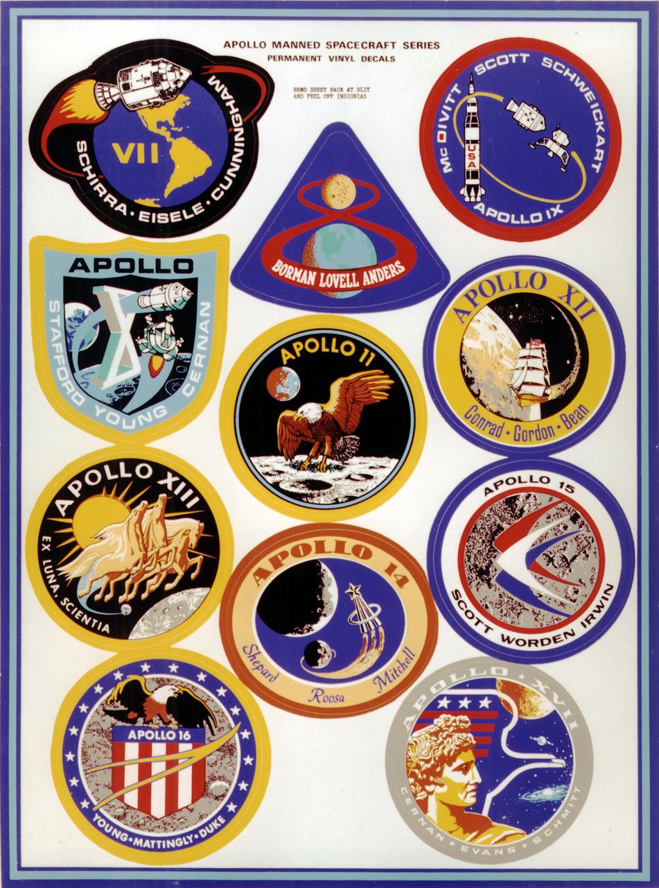
This montage depicts the flight crew patches for the manned Apollo 7 thru Apollo 17 missions. The Apollo 7 through 10 missions were basically manned test flights that paved the way for lunar landing missions. Primary objectives met included the demonstration of the Command Service Module (CSM) crew performance; crew/space vehicle/mission support facilities performance and testing during a manned CSM mission; CSM rendezvous capability; translunar injection demonstration; the first manned Apollo docking, the first Apollo Extra Vehicular Activity (EVA), performance of the first manned flight of the lunar module (LM); the CSM-LM docking in translunar trajectory, LM undocking in lunar orbit, LM staging in lunar orbit, and manned LM-CSM docking in lunar orbit. Apollo 11 through 17 were lunar landing missions with the exception of Apollo 13 which was forced to circle the moon without landing due to an onboard explosion. The craft was,however, able to return to Earth safely. Apollo 11 was the first manned lunar landing mission and performed the first lunar surface EVA. Landing site was the Sea of Tranquility. A message for mankind was delivered, the U.S. flag was planted, experiments were set up and 47 pounds of lunar surface material was collected for analysis back on Earth. Apollo 12, the 2nd manned lunar landing mission landed in the Ocean of Storms and retrieved parts of the unmanned Surveyor 3, which had landed on the Moon in April 1967. The Apollo Lunar Surface Experiments Package (ALSEP) was deployed, and 75 pounds of lunar material was gathered. Apollo 14, the 3rd lunar landing mission landed in Fra Mauro. ALSEP and other instruments were deployed, and 94 pounds of lunar materials were gathered, using a hand cart for first time to transport rocks. Apollo 15, the 4th lunar landing mission landed in the Hadley-Apennine region. With the first use of the Lunar Roving Vehicle (LRV), the crew was bale to gather 169 pounds of lunar material. Apollo 16, the 5th lunar landing mission, landed in the Descartes Highlands for the first study of highlands area. Selected surface experiments were deployed, the ultraviolet camera/spectrograph was used for first time on the Moon, and the LRV was used for second time for a collection of 213 pounds of lunar material. The Apollo program came to a close with Apollo 17, the 6th and final manned lunar landing mission that landed in the Taurus-Littrow highlands and valley area. This mission hosted the first scientist-astronaut, Schmitt, to land on the Moon. The 6th automated research station was set up, and 243 ponds of lunar material was gathered using the LRV.