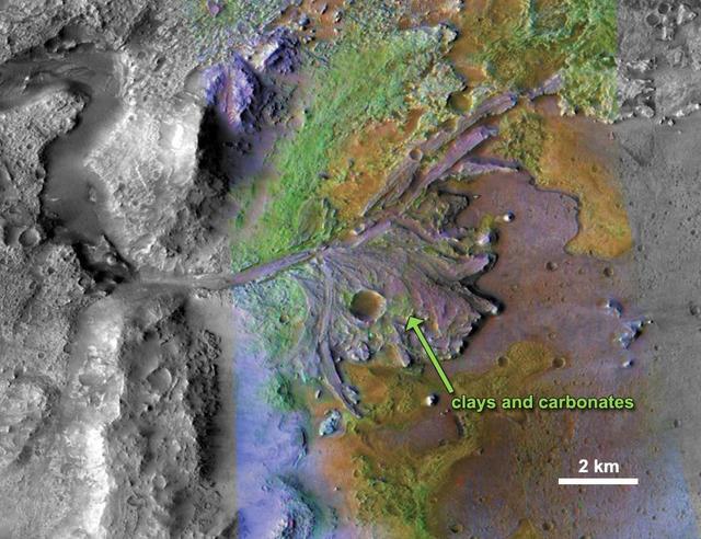
On ancient Mars, water carved channels and transported sediments to form fans and deltas within lake basins. Spectral data acquired by NASA Mars Reconnaissance Orbiter, indicate chemical alteration by water.
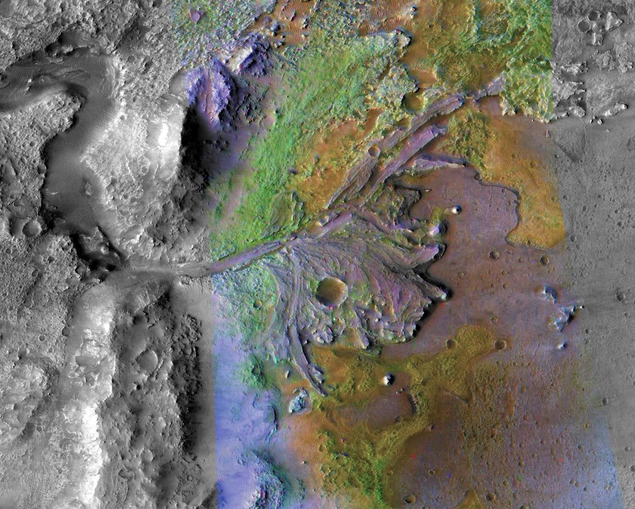
This image is of Jezero Crater on Mars, the landing site for NASA's Mars 2020 mission. It was taken by instruments on NASA's Mars Reconnaissance Orbiter (MRO), which regularly takes images of potential landing sites for future missions. On ancient Mars, water carved channels and transported sediments to form fans and deltas within lake basins. Examination of spectral data acquired from orbit show that some of these sediments have minerals that indicate chemical alteration by water. Here in Jezero Crater delta, sediments contain clays and carbonates. https://photojournal.jpl.nasa.gov/catalog/PIA23239
NASA image acquired December 17, 2010 In mid-December 2010, suspended sediments transformed the southern end of Lake Michigan. Ranging in color from brown to green, the sediment filled the surface waters along the southern coastline and formed a long, curving tendril extending toward the middle of the lake. The Moderate Resolution Imaging Spectroradiometer (MODIS) on NASA’s Aqua satellite captured these natural-color images on December 17, 2010 (top), and December 10, 2010 (bottom). Such sediment clouds are not uncommon in Lake Michigan, where winds influence lake circulation patterns. A scientificpaper published in 2007 described a model of the circulation, noting that while the suspended particles mostly arise from lake-bottom sediments along the western shoreline, they tend to accumulate on the eastern side. When northerly winds blow, two circulation gyres, rotating in opposite directions, transport sediment along the southern shoreline. As the northerly winds die down, the counterclockwise gyre predominates, and the smaller, clockwise gyre dissipates. Clear water—an apparent remnant of the small clockwise gyre—continues to interrupt the sediment plume. George Leshkevich, a researcher with the U.S. National Oceanic and Atmospheric Administration, explains that the wind-driven gyres erode lacustrine clay (very fine lakebed sediment) on the western shore before transporting it, along with re-suspended lake sediments, to the eastern shore. On the eastern side, the gyre encounters a shoreline bulge that pushes it toward the lake’s central southern basin, where it deposits the sediments. The sediment plume on December 17 followed a windy weather front in the region on December 16. NASA image courtesy MODIS Rapid Response Team at NASA GSFC. Caption by Michon Scott. Instrument: Aqua - MODIS <b><a href="http://www.nasa.gov/centers/goddard/home/index.html" rel="nofollow">NASA Goddard Space Flight Center</a></b> enables NASA’s mission through four scientific endeavors: Earth Science, Heliophysics, Solar System Exploration, and Astrophysics. Goddard plays a leading role in NASA’s accomplishments by contributing compelling scientific knowledge to advance the Agency’s mission. <b>Follow us on <a href="http://twitter.com/NASA_GoddardPix" rel="nofollow">Twitter</a></b> <b>Join us on <a href="http://www.facebook.com/pages/Greenbelt-MD/NASA-Goddard/395013845897?ref=tsd" rel="nofollow">Facebook</a></b> To read more about this image go to: <a href="http://earthobservatory.nasa.gov/IOTD/view.php?id=48511" rel="nofollow">earthobservatory.nasa.gov/IOTD/view.php?id=48511</a>
STS070-705-094 (13-22 JULY 1995) --- The southern half (about 70 miles in this view) of the Tifernine dunes of east-central Algeria appears on this view. The Tifernine dune-sea is one of the more dramatic features visible from the Shuttle when flying over the Sahara Desert. The dunes lie in a basin of dark-colored rocks heavily cut by winding stream courses (top right). Very occasional storms allow the streams to erode the dark rocks and transport the sediment to the basin. Westerly winds then mold the stream sediments into the complex dune shapes so well displayed here. North at bottom.
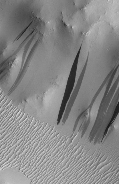
The light-toned deposits that formed in two gully sites on Mars during the Mars Global Surveyor (MGS) Mars Orbiter Camera (MOC) mission in the 1999 to 2005 period are considered to be the result of sediment transport by a fluid with the physical properties of liquid water. The young, light-toned gully deposits were found in a crater in Terra Sirenum (see PIA09027 or MOC2-1618) and in a crater east of the Hellas basin in the Centauri Montes region (see PIA09028 or MOC2-1619). In their study of how the light-toned gully deposits may have formed, the MOC team considered their resemblance to light- and dark-toned slope streaks found elsewhere on Mars. Slope streaks are most commonly believed to have formed by downslope movement of extremely dry, very fine-grained dust, through processes thought by some to be analogous to terrestrial snow avalanche formation. http://photojournal.jpl.nasa.gov/catalog/PIA09030
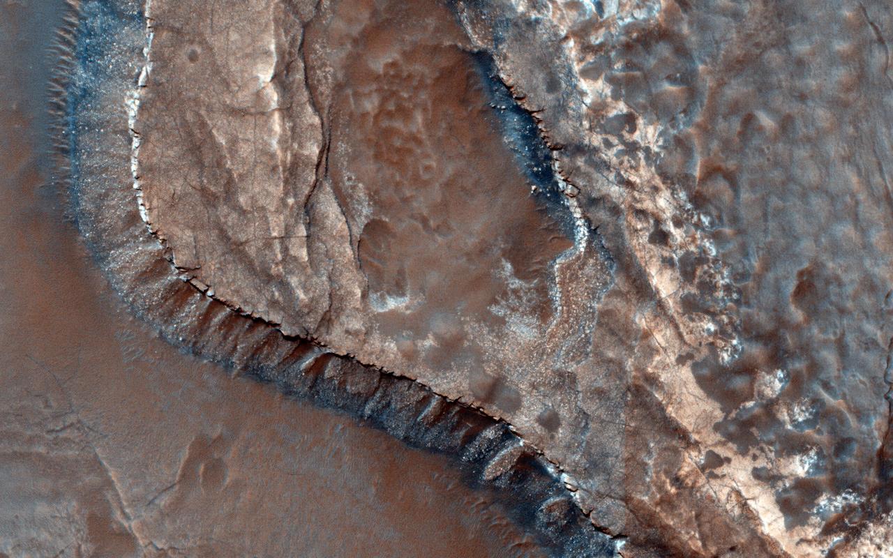
The sinuous ridges in this image display strong characteristics of ancient meandering riverbeds that are preserved as inverted topography (blue). The ancient river sediments that make up the ridges might have allowed fluids to produce cements (e.g., calcite or iron oxides) to make the channel lithology resistant to weathering and erosion. Later, physical and/or chemical processes removed the weaker surrounding flood plain material and left inverted river channels, or "positive relief." On closer inspection, degradation along sections of some inverted channels display large blocks of cemented sediment that were transported downslope by mass wasting. The sinuous character of the ridges resembles multi-thread river branches, implying that the ancient river flowed down a gentle to nearly horizontal slope (i.e., a moderate to low stream gradient). This ancient river was a mature meandering system, with flow from south to north. Multiple branches that diverted from the main flow later converged back with it. http://photojournal.jpl.nasa.gov/catalog/PIA20210
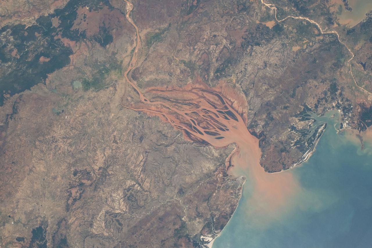
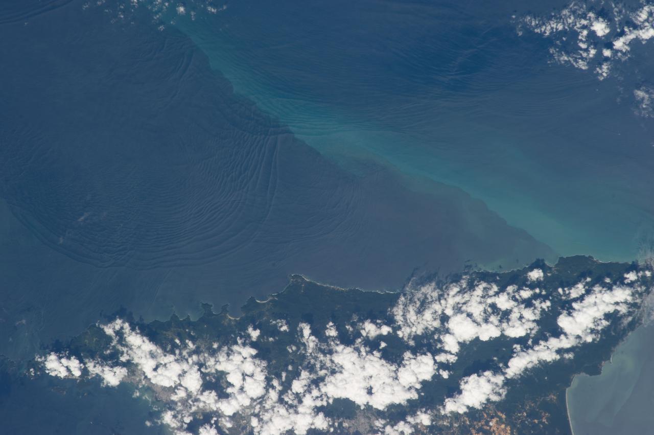
iss071e218069 (June 26, 2024) -- On Madagascar's northwestern coast, the Mozambique Channel flows inland to the Betsiboka River, forming Bombetoka Bay. The reddish-brown color is the result of iron-rich sediment transporting through, creating a striking visual marker for astronauts aboard the International Space Station. This photograph was taken as the orbiting laboratory soared 266 miles above Earth.
Planetary protection engineers at NASA's Jet Propulsion Laboratory in Southern California swab engineering models of the tubes that will store Martian rock and sediment samples as part of NASA’s Mars 2020 Perseverance mission. Team members wanted to understand the transport of biological particles when the rover is taking rock cores. These measurements helped the rover team design hardware and sampling methods that meet stringent biological contamination control requirements. https://photojournal.jpl.nasa.gov/catalog/PIA23718
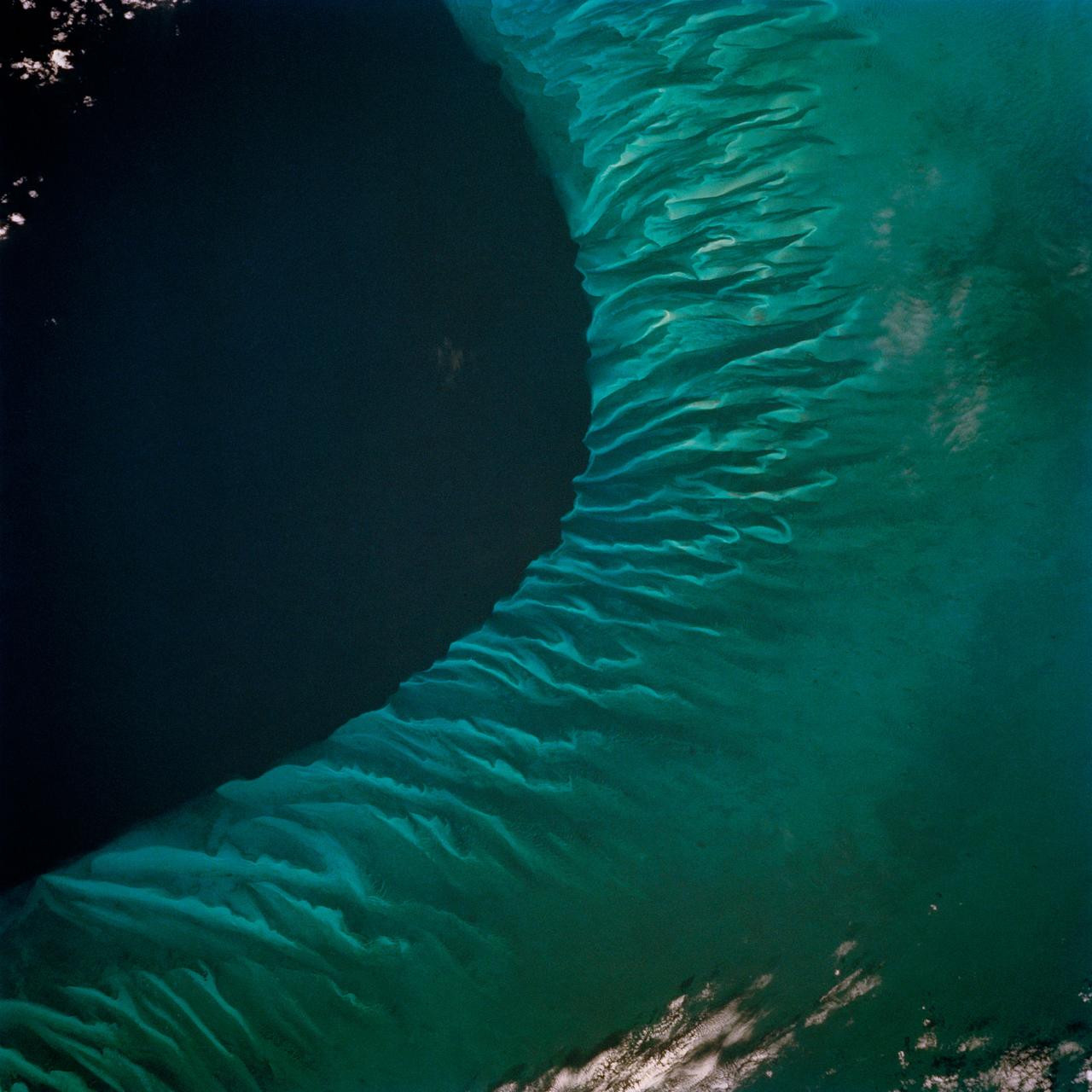
STS062-85-031 (4-18 March 1994) --- The shallow platforms (bright blue) and deep channels (dark blue) of the Bahamas provide a striking visual from space. On a finer scale, delicate patterns are created by the islands, sandbars and tidal channels. This view features a portion of the Tongue of the Ocean, one of the large deep water sounds in the western Bahamas. On the platform along the edge of the Tongue of the Ocean are convoluted sandbars bordering channels which fall into the deeper water. These channels provide an avenue for transport of sediment off the shallow platform (3-10 meters) into the deeper water (1,800 meters).
STS062-85-021 (4-18 March 1994) --- The Mississippi River is the largest river system in North America. Its delta is a typical example of the bird's foot class of river deltas. It drains nearly 3 1/2 million square kilometers of real estate and is estimated to carry 2.4 billion kilograms (more than 500 million tons) of sand, silt, and clay to the Gulf of Mexico annually. Most of this sediment is deposited as a delta at the mouth of the river where the velocity of the river water is slowed and its ability to transport sediment is accordingly diminished. Continued deposition at such a site progrades the delta or extends it seaward into the Gulf as much as 150 meters each year until such time as a flooding episode finds a shorter more efficient channel to deliver sediment-laden river waters to the Gulf. At that time the old delta is abandoned and the river begins to build a new delta. In time, compaction of the sediment in the old delta causes it to subside forming first marshes, then bays. This and the modifying effects of coastal waves eventually allow the sea to reclaim much of the temporary land area of the delta. This sequence has repeated itself over and over again at the Mississippi Delta. In this photograph, the present day active Balize delta is shown. According to NASA scientists it is the youngest of the recent delta lobes having begun its seaward pro-gradation only some 600 - 800 years ago. The main channel of the river is 2 kilometers wide and 30 - 40 meters deep. Natural levees here are almost 1 kilometer wide and 3 to 4 meters above sea level. Along the active distributaries of the lower delta, natural levees are less than 100 meters wide and generally less than 0.5 meters above sea level. The bird's foot appearance of deltas such as this is characteristic of low coastal energy conditions - that is, low levels of tidal fluctuation and generally low wave energy. The interdistributary bays are extremely shallow, usually less than a few meters, and contain brackish to normal marine waters except during times of flooding, when fresh water fills the bays. Sedimentation within the bays is very slow, occurring only during flood periods. Along the west side of the river, a highway has been built southeastward to Venice.
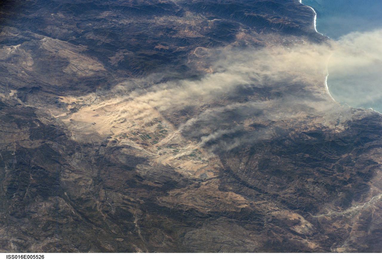
ISS016-E-005526 (21 Oct. 2007) --- Dust plumes, Baja California, Mexico are featured in this image photographed by an Expedition 16 crewmember on the International Space Station. A major dust plume and several minor plumes were raised during the strong, dry Santa Ana winds of October 2007. The light brown dust was transported west out to the Pacific Ocean (top right). According to meteorologists, Santa Ana winds, because they are warm, dry and strong, reduce soil moisture and generate frequent dust storms such as this. On this occasion, the Santa Anas supported the outbreak of fires in southern California resulting in significant damage to homes in hilly, wooded country. Dust plumes are known to start from relatively small, dust-prone areas. Here the plumes rise from the Real del Castillo agricultural valley--25 miles long, and part of Mexico's wine-producing region--surrounded by rocky hills in northern Baja California. Specifically, the dust is rising from spreads of loose sediment known as alluvial fans. Small streams from the local hills carry sediment with every rainstorm and deposit it at the foot of small canyons on the east side of the valley. It is notable that the vegetated farmland itself--the small rectangular pattern on the valley floor--protects the soil from the wind and is not producing dust plumes.
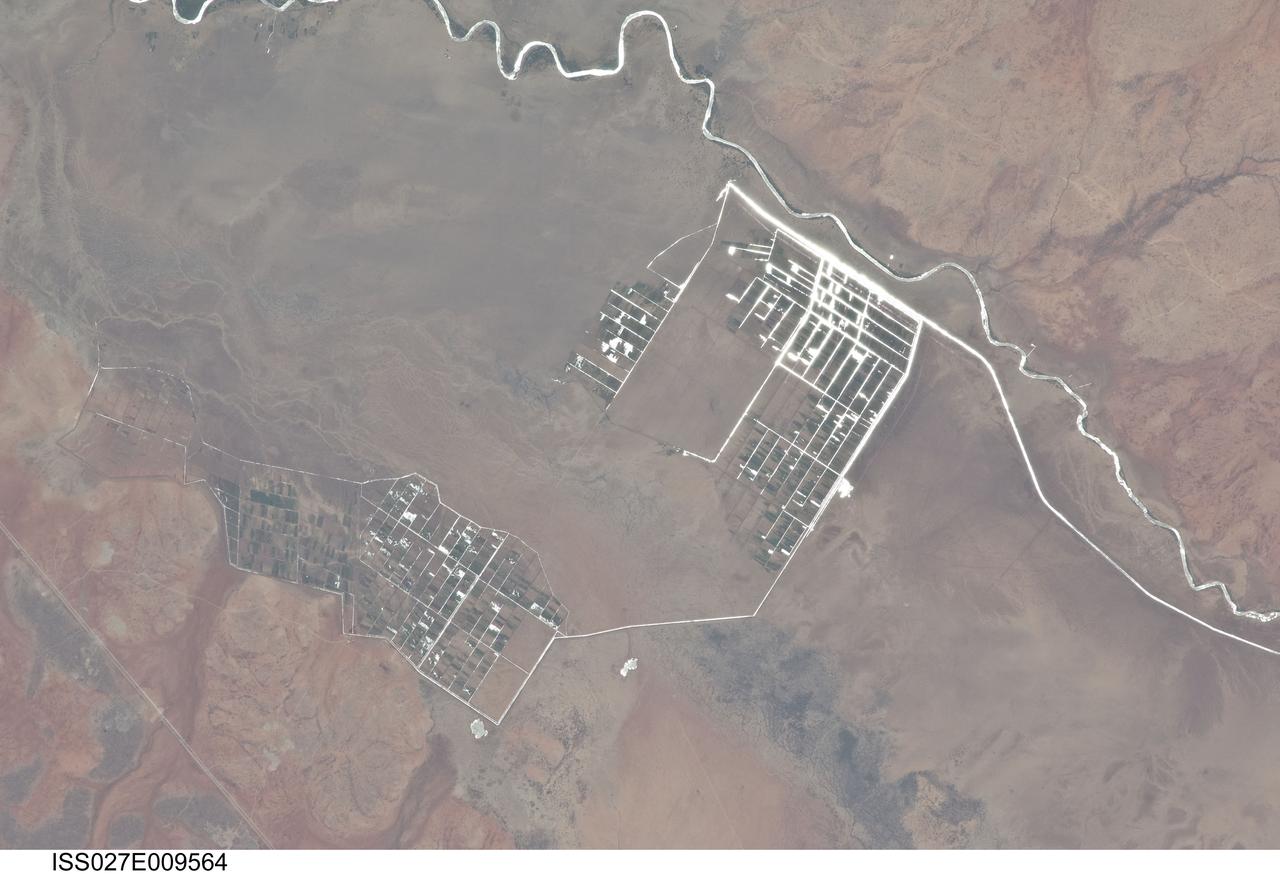
ISS027-E-009564 (31 March 2011) --- Agricultural fields along the Shebelle River in Ethiopia are featured in this image photographed by an Expedition 27 crew member on the International Space Station. The Shebelle River supports limited agricultural development within the arid to semi-arid Ogaden Plateau region of southeastern Ethiopia. This detailed photograph illustrates a network of irrigation canals and fields located approximately 42 kilometers to the west-northwest of the city of Gode, Ethiopia. Floodplain sediments and soils are dark brown to gray (center), and contrast with reddish rocks and soils of the adjacent plateau. Water in the Shebelle River, and the irrigation canals, has a bright, mirror-like appearance due to sunglint, or light reflecting off the water surface back towards the observer on the space station. Vegetation in the floodplain (bottom center) and agricultural fields is dark green. The river water supports a variety of crops?the most common being sorghum and maize?as well as grazing for livestock (cattle, sheep, goats, and camels). The Shebelle River has its headwaters in the Ethiopian Highlands, and transports water and sediment 1,000 kilometers to the southeast across Ethiopia, continuing an additional 130 kilometers into neighboring Somalia. The Shebelle River does not reach the Indian Ocean during most years, but disappears into the sands near the coast in Somalia. During periods of heavy rainfall and flooding however, the Shebelle can reach the Indian Ocean.
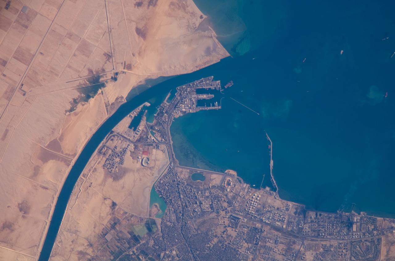
ISS016-E-019375 (30 Dec. 2007) --- Port of Suez, Egypt is featured in this image photographed by an Expedition 16 crewmember on the International Space Station. The Port of Suez is located in Egypt along the northern coastline of the Gulf of Suez. The port and city are the southern terminus of the Suez Canal that transits through Egypt and debouches into the Mediterranean Sea near Port Said. The port serves vessels transporting general cargo, oil tankers, and both commercial and private passenger vessels. The port is also an important waypoint for Muslim pilgrims traveling to and from Mecca in Saudi Arabia. Several large vessels are visible in the Gulf of Suez and berthed at various docks around the port. An extensive petroleum refinery complex forms the southern coastal boundary of the Port of Suez. At the time this image was acquired, gaseous byproducts of petroleum processing were being burned off -- as indicated by a smoke plume extending southwards into the Gulf of Suez (lower right). This view also captures several regions of greenish blue coloration in the Gulf. These are most probably sediments stirred up by passage of ships traveling to and from the Port. Similarly-colored regions along the coastline are bottom sediments visible through the shallow water column.
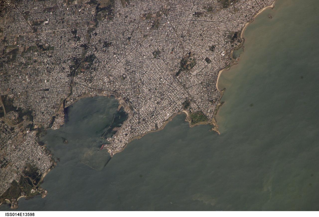
ISS014-E-13598 (29 Jan. 2007) --- Montevideo, Uruguay is featured in this image photographed by an Expedition 14 crewmember on the International Space Station. Reflective roofing materials and dark asphalt streets outline the urban grid pattern of Uruguay's capital city of Montevideo in this image. The city may be viewed as a precursor of the predicted global population shift from dominantly rural to urban environments (by 2030, according to recent United Nations estimates) -- nearly half of Uruguay's total population now lives in the Montevideo metropolitan area. Located on the southern coastline of Uruguay along the Rio de la Plata, Montevideo Bay provides an important harbor and port facilities for transport of South American agricultural products. This view is of sufficient resolution (approximately 7 meters/pixel) to discriminate between dark green canopied tree cover and light green grass - important information for study of urban ecology and climate, as well as city water use planning - in a large golf course located at the southern edge of the city (near center right). Sediment plumes along the coastline to the southeast of the city are also visible; rough patterns in the water surface of Montevideo Bay and the Rio de la Plata are a combination of wind disturbance and sediments.
ISS012-E-15035 (12 Jan. 2006) --- The confluence of the Ohio and Mississippi Rivers at Cairo, Illinois is featured in this image photographed by an Expedition 12 crew member on the International Space Station. The Ohio River becomes a tributary of the Mississippi River directly to the south of Cairo, Illinois, a small city on the spit of land where the rivers converge (at center of image). Brown sediment-laden water flowing generally northeast to south from the Ohio River is distinct from the green and relatively sediment-poor water (northwest- to south-flowing) of the Mississippi River. The coloration of the rivers in this image is reversed from the usual condition of a green Ohio and a brown Mississippi. According to scientists, this suggests that recent precipitation in the Ohio River watershed, with very high rainfall over the Appalachians and the northeastern United States in December 2005, has led to a greater sediment load in the Ohio waters. The distinct boundary between the two river’s waters indicates that little to no mixing occurs even 3-4 miles (5-6 kilometers) downstream. The city of Cairo became a prosperous port following the Civil War due to increased riverboat and railroad commerce. Small features on the Ohio are river barges and indicate the continued importance of Cairo as a transport hub. Flooding of the Ohio and Mississippi Rivers presents a continual danger to the city; this danger is lessened by the Birds Point-New Madrid Floodway that begins directly to the south of the river confluence. The floodway lowers flood stages upstream (such as at Cairo) and adjacent to the floodway during major flood events. Part of the extensive levee system associated with flood control of the Mississippi River is visible in the image. Barlow Bottoms (image right), located in adjacent Kentucky, are a wetlands bird watching location that is replenished by periodic floods and releases of Ohio River water.
This image shows the northern terminus of an outflow channel located in the volcanic terrains of Amenthes Planum. The channel sources from the Palos impact crater to the south, where water flowed into the crater from Tinto Vallis and eventually formed a paleo lake. As rising lake levels breached through the crater's rim and inundated the plains to the north, the resulting high velocity, large discharge floods plucked out and eroded the volcanic plains scouring out the "Palos Outflow Channel" and the streamlined mesa-islands on its floor. These streamlined forms are the eroded remnants of plains material sculpted by catastrophic floods and are not sediment deposits emplaced by lower magnitude stream flows. Both the fluvial channel floor and the volcanic island surfaces are densely cratered by impacts suggesting that both the surfaces and the flood events are ancient. The morphology (shape) of the channel system and its islands have been preserved through the eons, but water has long been absent from this drainage system. Since then, winds have transported light-toned sediments across this terrain forming extensive dune fields within the channel system, on the floors of impact craters, and in other protected locations in the Palos Outflow Channel region. A closer look shows chevron, or fish-bone shaped, light-toned dunes located near the top of the image where numerous smaller channels have cut through the landscape. These dunes likely started out as Transverse Aeolian Ridges (TAR) that form perpendicular to the prevailing wind direction where the wind-blown sediment supply is scarce. This intriguing morphology likely reflects changes in the prevailing wind environment over time. http://photojournal.jpl.nasa.gov/catalog/PIA21023
ISS034-E-032377 (18 Jan. 2013) --- Internal waves off Northern Trinidad are featured in this image photographed by an Expedition 34 crew member on the International Space Station. This photograph shows the north coast of the island of Trinidad in the southeastern Caribbean Sea, where heating of the land is setting off the growth of cumulus clouds. The light blue northwest-southeast trending plume at center is sediment from one of the rivers that flows into the sea here. Adjacent to, and appearing to cross the sediment plume, a series of subtle interacting arcs can be seen in the sea. These are known as internal waves which are the surface manifestation of slow waves moving tens of meters beneath the sea surface. These produce enough of an effect on the sea surface to be seen from space, but only where they are enhanced due to reflection of sunlight, or sunglint, back towards the space station. The image shows at least three sets of internal waves interacting. The most prominent set (top left) shows a “packet” of several waves moving from the northwest due to the tidal flow towards the north coast of Trinidad. Two less prominent, younger sets can be seen further out to sea. A very broad set enters the view from the north and northeast, and interacts at top center with the first set. All the internal waves are probably caused by the shelf break near Tobago (outside the image to top right). The shelf break is the step between shallow seas (around continents and islands) and the deep ocean. It is the line at which tides usually start to generate internal waves. The sediment plume at center is embedded in the Equatorial Current (also known as the Guyana Current) and is transporting material to the northwest—in almost the opposite direction to the movement of the internal waves. The current flows strongly from east to west around Trinidad, all the way from equatorial Africa, driven by year-round easterly winds. Seafarers in the vicinity of Trinidad are warned that the current, and its local reverse eddies, make navigation of smaller craft in these waters complicated and sometimes dangerous.
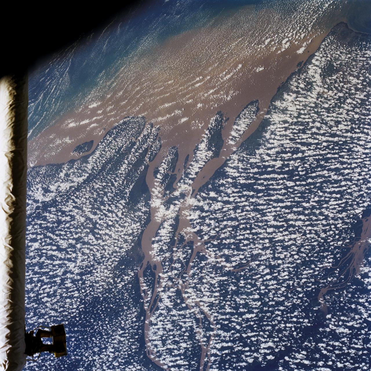
STS046-80-009 (31 July-8 Aug. 1992) --- A view of the mouth of the Amazon River and the Amazon Delta shows a large sediment plume expanding outward into the Atlantic Ocean. The sediment plume can be seen hugging the coast north of the Delta. This is caused by the west-northwest flowing Guyana Current. The large island of Marajo is partially visible through the clouds.
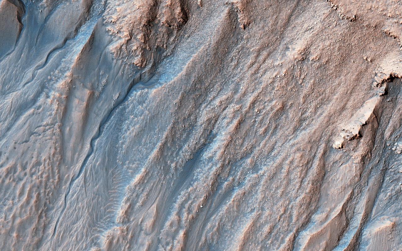
Gullies probably formed along the bouldery layers in the upper slopes of this unnamed crater within the last few million years. Gullies eroded these crater slopes and transported sediment downslope forming debris aprons multiple times. These older apron surfaces were cut by numerous fractures running perpendicular to the slope. Subsequent episodes of gully activity eroded through these fractures and deposited new aprons. On the floor of the crater are ridges with bouldery layers. These ridges may mark the furthest extent of glaciers that predate much of the original gully activity. Bright flows continue to form in these gullies seasonally. In the upper gully regions, long shadows cast by jagged outcrops allow scientists to determine the heights and depths of landforms by measuring the length of the shadows cast by the ridges onto the gully floor. https://photojournal.jpl.nasa.gov/catalog/PIA23020
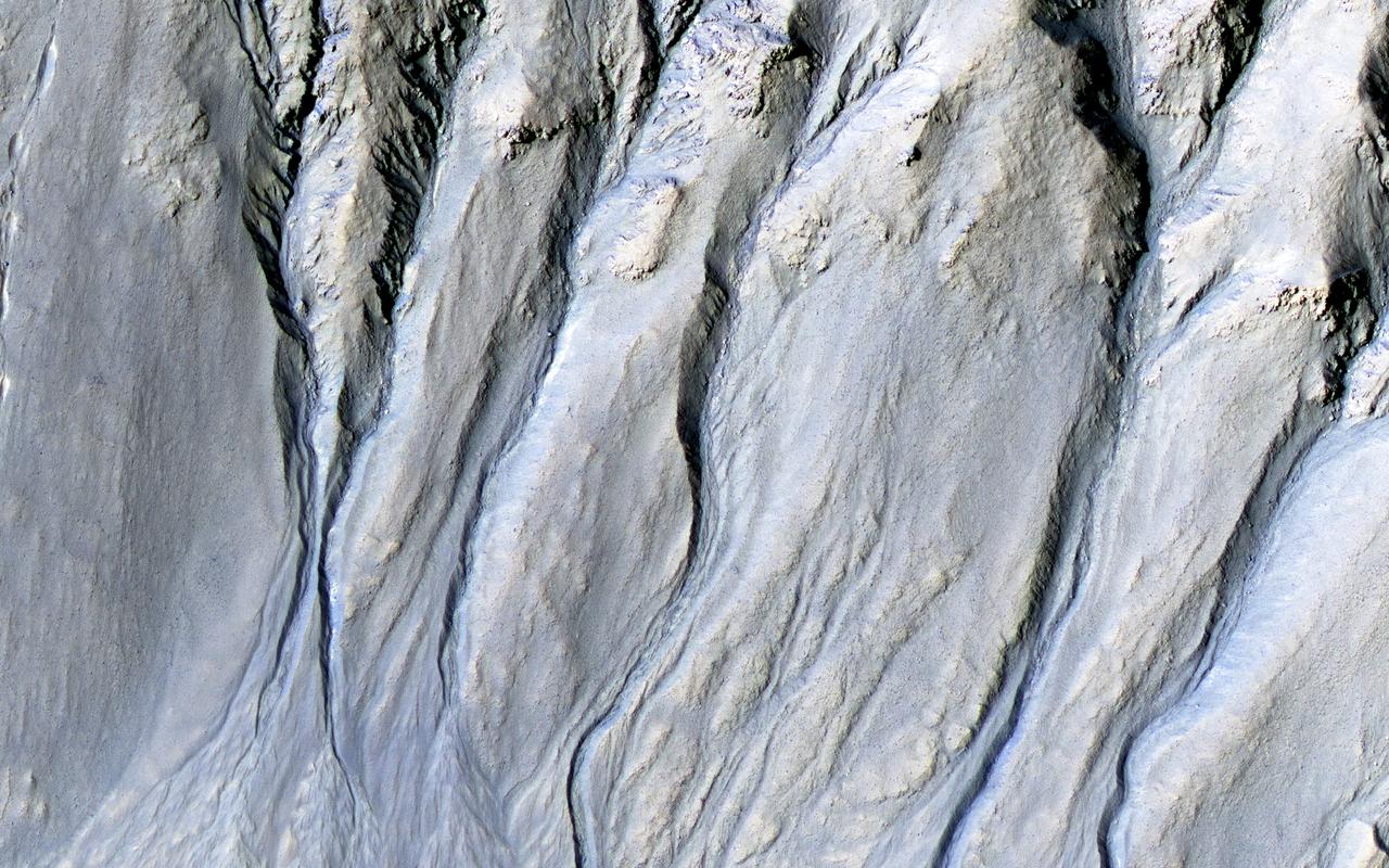
Intricate gullies have formed on the northern wall of this impact crater located in the Terra Cimmeria region in this image from NASA's Mars Reconnaissance Orbiter (MRO). This crater may have formed in a region rich in ground water. This ground water likely flowed down the wall, eventually eroding numerous gullies while carrying sediments to form fan deposits. Ultimately the water likely infiltrated and froze beneath the surface. Other hypotheses say gullies form through carbon dioxide frost avalanches that we can see today. What about this chain of pits snaking their way downhill? After material was transported, subsurface voids may have formed, removing support for the overlying material. The collapse of the surface into the cavities below likely resulted in the pits and troughs, perhaps beginning a new cycle of gully formation. https://photojournal.jpl.nasa.gov/catalog/PIA22239

ISS017-E-013789 (19 Aug. 2008) --- Desert erosion in Libya is featured in this image photographed by an Expedition 17 crewmember on the International Space Station. This detailed view (covering 13 kilometers) shows the classic patterns of an erosional desert landscape located 300 kilometers south of Libya's Mediterranean coast. Widespread indented patterns are low escarpments and stream terraces generated by stream erosion -- on those few occasions in any decade when enough rain falls for streams to flow. The only areas with active sediment deposition are the stream beds which appear in this image as sinuous zones with a distinct component of black minerals, resulting in a darker coloration than adjacent low escarpments. Sediment is transported into the area from a volcanic landscape immediately upstream to the west. Other stream-generated features are several relict stream banks, one of which even shows both of the original parallel banks. According to scientists, the ancient stream banks are preserved from erosion by various hardening cements (mainly calcium carbonate and gypsum) introduced by the streams when they were active, probably during wetter climates in the past two million years. Relict stream courses show prior positions of streams, and also provide Earth analogs for similar features on Mars. The lack of vegetation is the first indication of the great aridity of the region, but sand dunes also appear as sinuous lines oriented perpendicular to the dominant northeasterly wind direction (transverse dunes). Assuming the dominant wind direction remains the same, these transverse dunes are expected to move further to the southwest over time. Some of the dunes cross the river courses, showing how seldom the river flows.
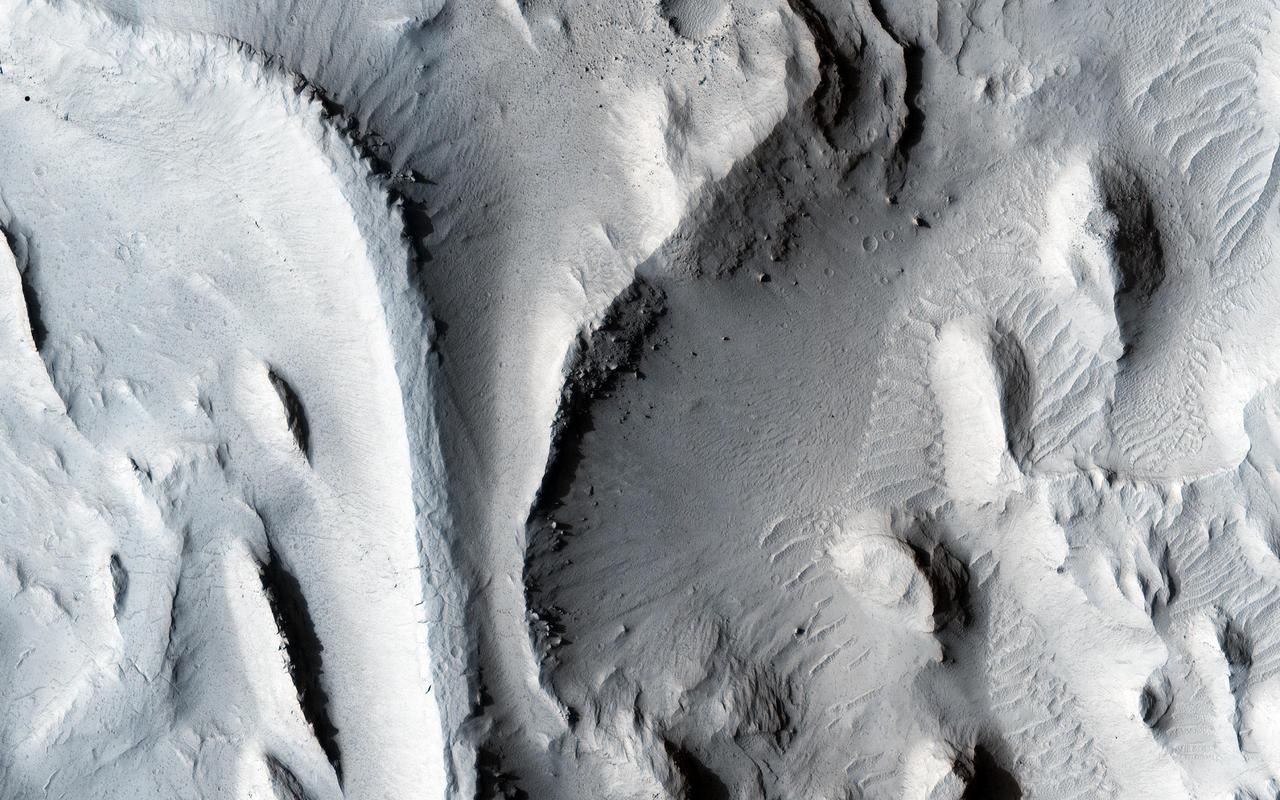
This image from NASA Mars Reconnaissance Orbiter shows the southwestern floor of a 50-kilometer diameter unnamed crater, about 100 kilometers northeast of Hellas Basin. The crater's rim is breached on both the north and south by a valley system that previously flowed across the crater floor, leaving behind an interesting array of channel patterns and deposits as it transported water and sediments into and out of the crater. In this image, we see a portion of the channel system along the southwestern crater floor near where the valley breaches the southern rim. The darker-toned surface has a pattern similar to the texture of a basketball, and blankets the region both in the channel belt and in the basin below the cliffs. Superposed on this patterned surface are clusters of larger, circular mounds that may be related to the thawing and freezing of ice-rich sediment, which is unusual at this relatively low latitude. Extensional cracks and clusters of pits make this topography more complicated. The southern part of this image reveals a prominent irregular scarp with light-toned layered deposits exposed along the margin beneath this textured surface. The light-toned layers look like an ancient mosaic in some areas as they are irregularly fractured and brecciated. Individual blocks and large boulders of this material are visible at full-resolution near the scarp, just about to fall and already lying on the debris slopes below the scarp. Some are brighter than the others: these may be dust-free, indicating that they have detached from the cliff more recently. http://photojournal.jpl.nasa.gov/catalog/PIA19850

ISS012-E-06456 (3 Nov. 2005) --- Salar de Uyuni, the largest Salar (salt flat) in the world, located within the Altiplano of Bolivia, South America is featured in this image photographed by an Expedition 12 crewmember on the International Space Station. The Altiplano is a high plateau formed during uplift of the Andes Mountains. The plateau harbors fresh and saltwater lakes, together with Salars, that are surrounded by mountains with no drainage outlets--all at elevations greater than 3,659 meters (12,000 feet) above mean sea level. The Salar de Uyuni covers approximately 8,000 square kilometers (3,100 square miles), and it is a major transport route across the Bolivian Altiplano due to its flatness. This image features the northern end of the Salar and the dormant volcano Mount Tunupa (image center). This mountain is high enough to support a summit glacier, and enough rain falls on the windward slopes to provide water for small communities along the base. The dark volcanic rocks comprising Mt. Tunupa are in sharp contrast with the white, mineral-crusted surface of the Salar. The major minerals are halite--common table salt--and gypsum--a common component of drywall. Relict shorelines visible in the surface salt deposits (lower right of the image) attest to the occasional presence of small amounts of water in the Salar. Sediments in the Salar basin record fluctuations in water levels that occurred as the lake that once occupied the Salar evaporated. These sediments provide a valuable paleoclimate record for the region. The dynamic geological history of the Altiplano is recorded in isolated "islands" within the salt flat (image left); these islands are typically built from fossil coral reefs covered by Andean volcanic rocks.

This early-morning view from the Mast Camera (Mastcam) on NASA's Curiosity Mars rover covers a field of view of about 130 degrees of the inner wall of Gale Crater. It was acquired during a period when there was very little dust or haze in the atmosphere, so conditions were optimal for long-distance imaging. The right side of the image fades into the glare of the rising sun. Mastcam's right-eye camera, which has a telephoto lens, took the component images on March 16, 2016, during the 1,284th sol, or Martian day, of Curiosity's work on Mars. The rover's location was on the "Naukluft Plateau" of lower Mount Sharp, inside Gale Crater. The view spans from west-northwest on the left to northeast on the right. Details of the morphology (shape and pattern of features) on the wall, which include gullies, channels and debris fans help geologists understand the processes that have shaped the crater and transported sediments -- sand, pebbles and larger rocks -- down to the floor of the crater. Some of the foothills show layers morphologically not unlike the layers Curiosity is exploring near the base of Mount Sharp, suggesting that the crater was filled along the north wall with sediments that have in large part now been eroded away, much as happened closer to Mount Sharp. The scene is presented with a color adjustment that approximates white balancing, to resemble how the terrain would appear under daytime lighting conditions on Earth. Figure 1 includes labels on three peaks of the crater wall, for scale and position reference. The peak labeled "A," near the left end of the panorama, is at azimuth 291.8 degrees east of north and 18.1 miles (29.1 kilometers) away from the rover's position. It rises about 6,200 feet (1,900 meters) above the closest point on the floor of the crater. Peak "B," at azimuth 357.2 degrees east of north (or 2.8 degrees from north), is about 17.6 miles (28.4 kilometers) away and rises about 3,900 feet (1,200 meters) above the base of its foothills. Peak "C," at azimuth 33.6 degrees east of north, is about 27.3 miles (45.5 kilometers) distant and rises about 6,200 feet (1,900 meters) above the base of its foothills. http://photojournal.jpl.nasa.gov/catalog/PIA20333
SL3-83-166 (July-September 1973) --- A vertical view of the Washington D.C. and the Baltimore, Maryland area is seen in the Skylab 3 Earth Resources Experiments Package S190-B (five-inch Earth terrain camera) photograph taken from the Skylab space station in Earth orbit. The Chesapeake Bay is on the right (east) side of the picture. The Potomac River flows through the Washington area in the lower left (southwest) corner of the photograph. Several transportation routes and major highways stand out very distinctly. Especially conspicuous are the beltways around the cities, Interstate 95 between Baltimore and the nation?s capitol and Interstate 70N leading west from Baltimore. The tunnel and harbor facilities in Baltimore show clearly, also. Identifiable features in the Washington area include the Capitol Building, the Mall area, Robert F. Kennedy Stadium (white circle), the five bridges across the Potomac, Andrews Air Force Base (on east loop), and the smaller Anacostia River. The extent of the urbanization in this area is dramatically illustrated in this picture. The photograph has sufficient resolution that the housing patterns for individual suburban areas are clearly defined with the houses shown as pink gray, wooded areas as dark green and cleared areas light green. Chesapeake Bay circulation patterns are indicated by contrast of dark and light blue. Sediment plumes (red) are seen entering the bay north and east of Baltimore. The bay bridge stands out white against the blue water. The detailed information contained in this one photograph will be of direct use to several EREP investigator teams in land use analysis, sedimentation and circulation patterns in the bay, and resource surveys of Maryland. All EREP photography is available to the public through the Department of Interior?s Earth Resources Observations Systems Data Center, Sioux Falls, South Dakota, 57198. Photo credit: NASA
ISS038-E-026862 (8 Jan. 2014) --- The Western Sahara Desert is featured in this image photographed by an Expedition 38 crew member on the International Space Station. The infrequent cloud bands over southern Mauritania were photographed with an oblique look angle so that the dark cloud shadows are also a prominent part of the view. Beneath the cloud the Aouker plateau of dark sedimentary rocks appears as a ragged, near-vertical escarpment at top right. Isolated remnants of the plateau appear as dark mesas (flat-topped hills) across the top and near the center of the image. The escarpment is about 250 meters high, with a field of orange-colored dunes at the base (upper right). Prevailing winds in this part of the Sahara Desert blow from the northeast. The wavy dunes are aligned transverse to these winds. The sand that makes the dunes is blown in from a zone immediately upwind (just out of the bottom of the image) where dry river beds and dry lakes provide large quantities of mobile sand for the wind to transport. This pattern is typical in the western Sahara Desert, where plateau surfaces are mostly dune free and dune fields are located in the surrounding lowlands where the larger rivers deposit quantities of sandy sediment on the few occasions when they flow-sometimes only once in decades.
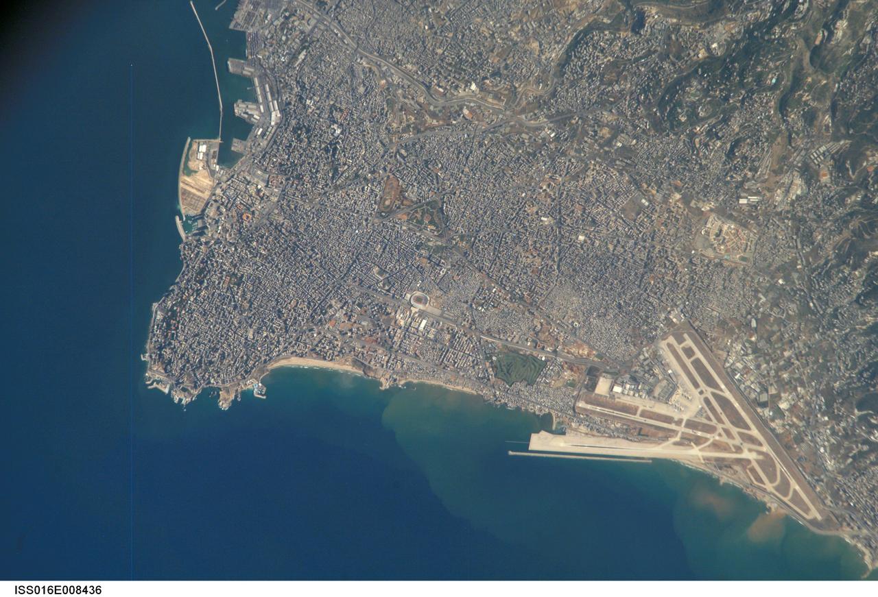
ISS016-E-008436 (26 Oct. 2007) --- Beirut Metropolitan Area, Lebanon is featured in this image photographed by an Expedition 16 crewmember on the International Space Station. The capital of Lebanon, Beirut is located along the southeastern shoreline of the Mediterranean Sea. According to geologists, the metropolitan area is built on a small peninsula composed mainly of sedimentary rock deposited over the past 100 million years or so. The growth of the city eastwards is bounded by foothills of the more mountainous interior of Lebanon (sparsely settled greenish brown region visible at upper right). While this sedimentary platform is stable, the country of Lebanon is located along a major transform fault zone, or region where the African and Arabian tectonic plates are moving laterally in relation to (and against) each other. This active tectonism creates an earthquake hazard for the country. The Roum Fault, one of the fault strands that is part of the transform boundary, is located directly to the south of the Beirut metropolitan area. Other distinctive features visible in this image include the Rafic Hariri Airport at lower right, the city sports arena at center, and several areas of green and open space (such a large golf course at center). Also visible in the image are several plumes of sediment along the coastline -- the most striking of which are located near the airport. The general lack of vegetation in the airport may promote higher degrees of soil transport by surface water runoff or wind.
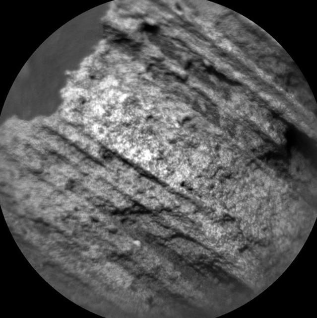
This image from the Chemistry and Camera (ChemCam) instrument on NASA's Curiosity Mars rover shows detailed texture of a rock target called "Yellowjacket" on Mars' Mount Sharp. This was the first rock target for ChemCam after checkout of restored capability for autonomous focusing. The image covers a patch of rock surface about 2.5 inches (6 centimeters) across. It was taken on May 15, 2015, during the mission's 986th Martian day, or sol. ChemCam's Remote Micro-Imager camera, on top of Curiosity's mast, captured the image from a distance of about 8 feet (2.4 meters). ChemCam also hit the target with laser pulses and recorded spectrographic information from the resulting flashes to reveal the chemical composition. Yellowjacket, located near an area called "Logan Pass" on lower Mount Sharp, is a layered sedimentary rock. The laser analysis yielded a composition very close to that of Mars soil and unlike the lakebed sedimentary compositions observed at lower elevations earlier in the mission. The soil-like composition may indicate that the rock formed from sediment transported by wind, rather than by water. http://photojournal.jpl.nasa.gov/catalog/PIA19661
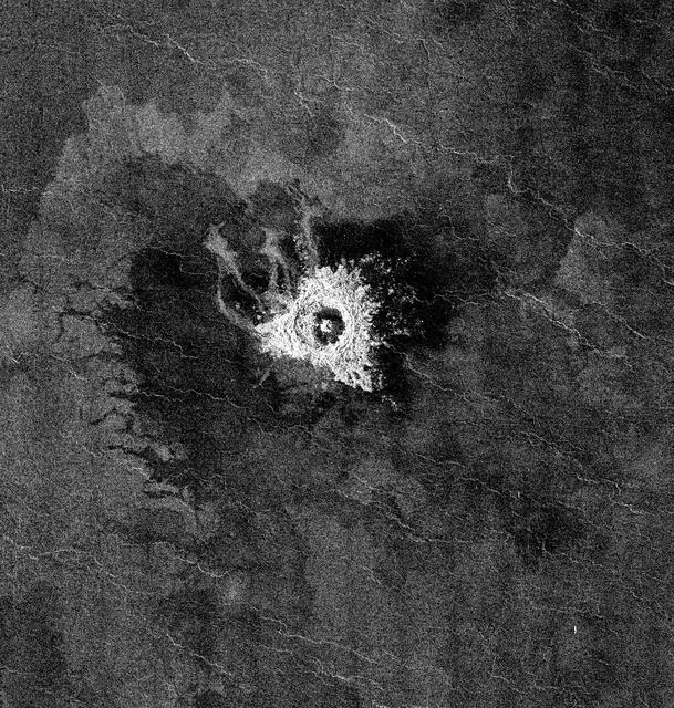
This full-resolution image from NASA Magellan spacecraft shows Jeanne crater, a 19.5 kilometer (12 mile) diameter impact crater. Jeanne crater is located at 40.0 degrees north latitude and 331.4 degrees longitude. The distinctive triangular shape of the ejecta indicates that the impacting body probably hit obliquely, traveling from southwest to northeast. The crater is surrounded by dark material of two types. The dark area on the southwest side of the crater is covered by smooth (radar-dark) lava flows which have a strongly digitate contact with surrounding brighter flows. The very dark area on the northeast side of the crater is probably covered by smooth material such as fine-grained sediment. This dark halo is asymmetric, mimicking the asymmetric shape of the ejecta blanket. The dark halo may have been caused by an atmospheric shock or pressure wave produced by the incoming body. Jeanne crater also displays several outflow lobes on the northwest side. These flow-like features may have formed by fine-grained ejecta transported by a hot, turbulent flow created by the arrival of the impacting object. Alternatively, they may have formed by flow of impact melt. http://photojournal.jpl.nasa.gov/catalog/PIA00472

This image was acquired on January 2, 2014 by NASA's Mars Reconnaissance Orbiter. Dune fields located among canyon wall slopes are also known as "wall dune fields" and are further identified as either climbing or falling. Falling dunes are defined as large bedforms with lee faces on the downhill side-indicating that this is the direction of their migration-and on moderate slopes greater than 10 to 12 degrees. (A lee face is the the down-wind side of a dune.) On Earth and Mars, these types of dunes are largely controlled by what is called "microtopography." Physical obstacles can accelerate and decelerate airflow, create turbulence, potentially enhancing erosion, deposition, and/or transport of dune sediment. This class of dune morphology is relatively rare across Mars. However, falling dunes (like these) and climbing fields are frequently located among the spur-and-gully walls in the Melas and Coprates chasmata (see the paper here). Here is one example, of active falling dunes on this large massif in east Coprates Chasma. More information is available at https://photojournal.jpl.nasa.gov/catalog/PIA22684
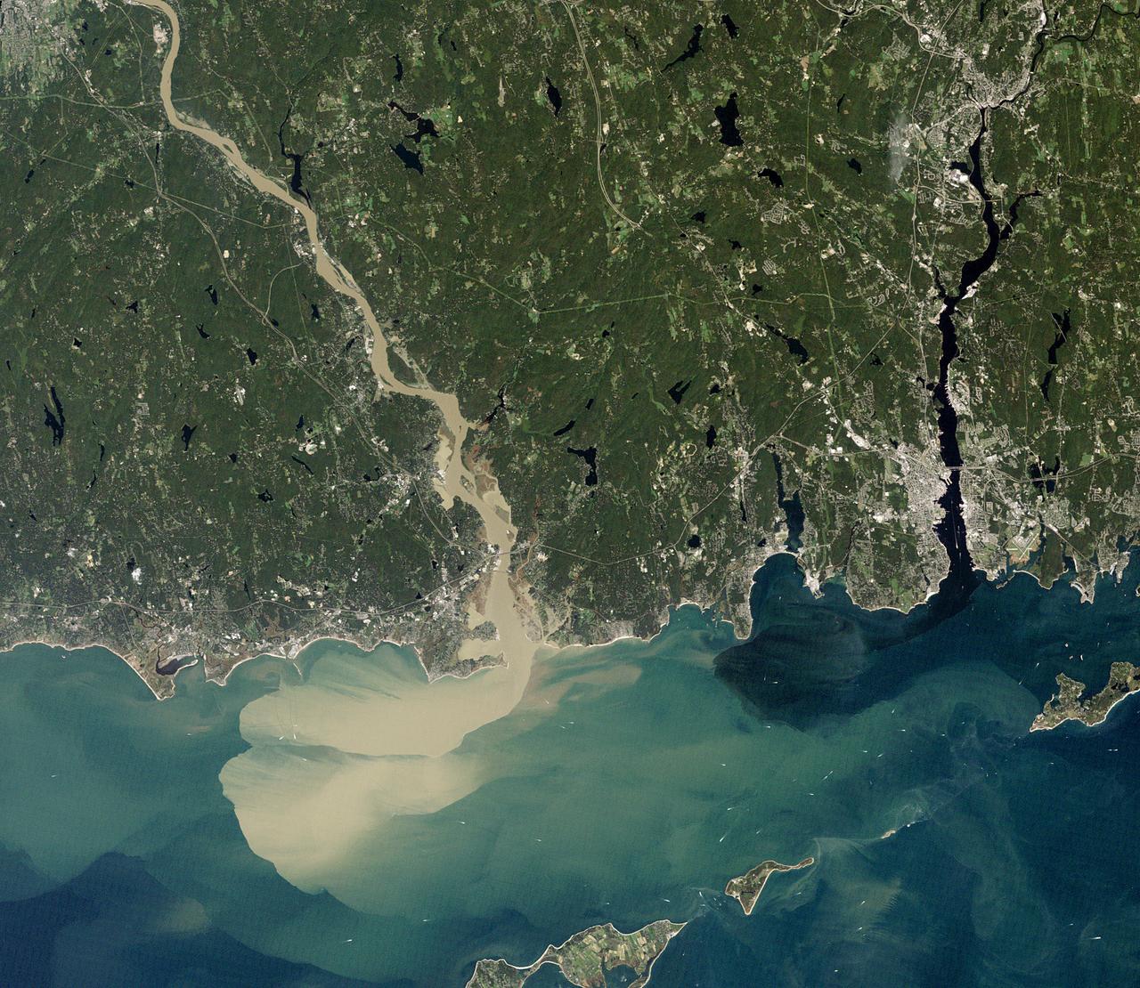
NASA image acquired September 2, 2011 To download the full high res go to: <a href="http://earthobservatory.nasa.gov/IOTD/view.php?id=52059" rel="nofollow">earthobservatory.nasa.gov/IOTD/view.php?id=52059</a> Nearly a week after Hurricane Irene drenched New England with rainfall in late August 2011, the Connecticut River was spewing muddy sediment into Long Island Sound and wrecking the region's farmland just before harvest. The Thematic Mapper on the Landsat 5 satellite acquired this true-color satellite image on September 2, 2011. With its headwaters near the Canadian border, the Connecticut River drains nearly 11,000 square miles (28,500 square kilometers) and receives water from at least 33 tributaries in Vermont, New Hampshire, Massachusetts, and Connecticut. The 410-mile river—New England's longest—enters Long Island Sound near Old Lyme, Connecticut, and is estimated to provide 70 percent of the fresh water entering the Sound. When Irene blew through the region on August 27-28, substantial portions of the Connecticut River watershed received more than 6 to 8 inches (15-20 centimeters) of rainfall, and several locations received more than 10 inches (25 centimeters). Whole towns were cut off from overland transportation—particularly upstream in Vermont, which suffered its worst flooding in 80 years. Thousands of people saw their homes flooded, if not washed off their foundations, at a time of year when rivers are usually at their lowest. Preliminary estimates of river flow at Thompsonville, Connecticut, (not shown in this image) reached 128,000 cubic feet per second (cfs) on August 30, nearly 64 times the usual flow (2,000 cfs) for early fall and the highest flow rate since May 1984. At the mouth of the river—where flow is tidal, and therefore not gauged—the peak water height reached 6.9 feet (2.1 meters) above sea level, almost a foot higher than at any time in the past 10 years. According to Suzanne O'Connell, an environmental scientist working along the Connecticut River at Wesleyan University, the torrent of water coursing through New England picked up silt and clay from the river valleys, giving it the tan color shown in the image above. At Essex, Connecticut, the turbidity (muddiness) of the water was 50 times higher than pre-Irene values. To the east, the Thames River appears to be carrying very little sediment at all on September 2. According to O'Connell, the Thames "drains glaciated terrain, so fine sediment was removed long ago." Most of the land surface in the Thames basin is "just bedrock, till, and glacial erratics." Unlike the Connecticut, areas within the Thames watershed only received 2 to 4 inches of rain in most locations. The flooding that occurred in the aftermath of Hurricane Irene inundated farmland in Massachusetts and Connecticut just before harvest time, the Associated Press noted. Crops were drowned under inches to feet of water. The substantial amounts of soil, sediment, and water deposited on land during the flood could also pose trouble for farmers in coming seasons. "It's notable that whole segments of river bank are just gone," said Andrew Fisk of the Connecticut River Watershed Council. "That's not just loss of sediment. That's land disappearing down river." <b>NASA Earth Observatory image by Robert Simmon, using Landsat 5 data from the U.S. Geological Survey Global Visualization Viewer. Caption by Michael Carlowicz, with interpretation help from Suzanne O'Connell, Wesleyan University, and Andrew Fisk, Connecticut River Watershed Council.</b> Instrument: Landsat 5 - TM Credit: <b><a href="http://www.earthobservatory.nasa.gov/" rel="nofollow"> NASA Earth Observatory</a></b> <b><a href="http://www.nasa.gov/centers/goddard/home/index.html" rel="nofollow">NASA Goddard Space Flight Center</a></b> enables NASA’s mission through four scientific endeavors: Earth Science, Heliophysics, Solar System Exploration, and Astrophysics. Goddard plays a leading role in NASA’s accomplishments by contributing compelling scientific knowledge to advance the Agency’s mission. <b>Follow us on <a href="http://twitter.com/NASA_GoddardPix" rel="nofollow">Twitter</a></b> <b>Like us on <a href="http://www.facebook.com/pages/Greenbelt-MD/NASA-Goddard/395013845897?ref=tsd" rel="nofollow">Facebook</a></b> <b>Find us on <a href="http://web.stagram.com/n/nasagoddard/?vm=grid" rel="nofollow">Instagram</a></b>
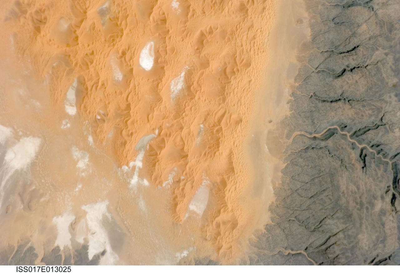
ISS017-E-013025 (12 Aug. 2008) --- The Tifernine Dune Field in Algeria is featured in this image photographed by an Expedition 17 crewmember on the International Space Station. The Tifernine Dune Field is located at the southernmost tip of the Grand Erg Oriental, a "dune sea" that occupies a large portion of the Sahara Desert in eastern Algeria. This view illustrates the interface between the yellow-orange sand dunes of the field and adjacent dark brown consolidated rocks of the Tinrhert Plateau to the south and east (right). NASA scientists point out that three distinct landform types are visible in the image, each providing information about past and present climate in the area. The oldest landform is represented by the rocks of the Tinrhert Plateau, which are characterized by a number of incised channels in the bedrock -- these formed during a wet and cool climate period, most probably by glacial meltwater streams. As the present dry and hot climate that characterizes the Sahara became established, water ceased to flow in these channels, and large amounts of drying sediment (sand, silt, and clay) were eroded and transported by predominantly northeast-southwest winds -- forming large linear dunes that roughly parallel the prevailing wind direction (center). The present climate regime is still hot and dry, but current wind directions are more variable, leading to the formation of star dunes -- recognizable by a starfish-like pattern when seem from above -- that are modifying the older large linear dunes. White to grey regions within the dune field are exposed deposits of silt and clay, together with evaporite minerals (such as halite, or common table salt) formed by evaporation of water that collected in small basins between the dunes.

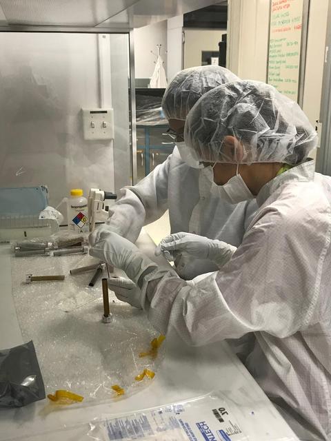
The new international satellite mission called Surface Water and Ocean Topography (SWOT) — slated for launch in late 2022 — will measure the height of Earth's surface water. The data the spacecraft will collect will help researchers understand and track the volume and location of water around the world. The satellite will assist with monitoring changes in floodplains and wetlands, measuring how much fresh water flows into and out of lakes and rivers and back to the ocean, and tracking regional shifts in sea level at scales never seen before. The satellite will also provide information on small-scale ocean currents that will support real-time marine operations affected by tides, currents, storm surge, sediment transport, and water quality issues. The payload is taking shape in a clean room at NASA's Jet Propulsion Laboratory in Southern California before being shipped to France. There, technicians and engineers from the French space agency Centre National d'Etudes Spatial (CNES), their prime contractor Thales Alenia Space, and JPL will complete the build and prepare the satellite for shipment to its California launch site at Vandenberg Air Force Base. JPL project manager Parag Vaze (pronounced vah-zay) is central to ensuring the handoff to his CNES counterpart Thierry Lafon goes smoothly. SWOT is being jointly developed by NASA and CNES, with contributions from the Canadian Space Agency (CSA) and United Kingdom Space Agency (UKSA). JPL, which is managed for NASA by Caltech in Pasadena, California, leads the U.S. component of the project. For the flight system, NASA is providing the Ka-band Radar Interferometer (KaRIn) instrument, a GPS science receiver, a laser retroreflector, and a two-beam microwave radiometer. CNES is providing the Doppler Orbitography and Radioposition Integrated by Satellite (DORIS) system, nadir altimeter, and the KaRIn RF subsystem (with support from the UKSA). CSA is providing the KaRIn high-power transmitter assembly. NASA is providing associated launch services. https://photojournal.jpl.nasa.gov/catalog/PIA24531
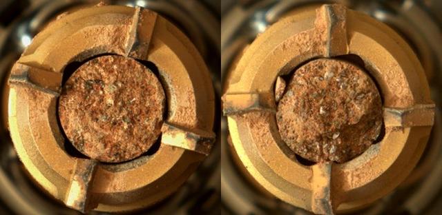
This pair of images shows two cylinders of rock the size of classroom chalk inside the drill of NASA's Perseverance rover from an outcrop called "Skinner Ridge" in Mars' Jezero Crater. The image of the rock core on the left, called "Swift Run," was taken by Perseverance's Mastcam-Z instrument on July 6, 2022, the 490th Martian day, or sol, of the mission. The image on the right, of the rock core called "Skyland," was taken on July 11, 2022, the 495th sol of the mission. Each core is about 0.5 inches, or 13 millimeters, in diameter and 2.4 inches, or 60 millimeters, long. They were taken from an ancient river delta in Jezero Crater, a fan-shaped area where, billions of years ago, a river once flowed into a lake and deposited rocks and sediment. Scientists believe these rock samples contain materials transported by water from potentially hundreds of miles outside of Jezero Crater. These rock cores have been sealed in ultra-clean sample tubes and stored in Perseverance's Sampling and Caching System as part of the mission's search for signs of ancient microbial life. The verification of ancient life on Mars carries an enormous burden of proof. A key objective for Perseverance's mission on Mars is astrobiology, including the search for signs of ancient microbial life. The rover will characterize the planet's geology and past climate, pave the way for human exploration of the Red Planet, and be the first mission to collect and cache Martian rock and regolith (broken rock and dust). Subsequent NASA missions, in cooperation with ESA (European Space Agency), would send spacecraft to Mars to collect these sealed samples from the surface and return them to Earth for in-depth analysis. The Mars 2020 Perseverance mission is part of NASA's Moon to Mars exploration approach, which includes Artemis missions to the Moon that will help prepare for human exploration of the Red Planet. https://photojournal.jpl.nasa.gov/catalog/PIA24927
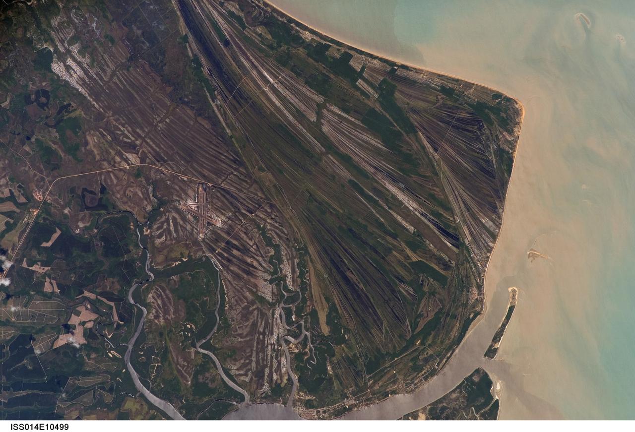
ISS014-E-10499 (23 Dec. 2006) --- Caravelas strandplain, Bahia Province, Brazil is featured in this image photographed by an Expedition 14 crewmember on the International Space Station. This view highlights a flat coastal landform known as a strandplain, or ancient shoreline. The image is dominated by numerous, fine parallel lines (trending diagonally from upper left to lower right), each of which is an ancient shoreline made up of sand transported from rivers to the north. The strandplain has been generated by these narrow shorelines accumulating against one another, line by line in their dozens or even hundreds, over thousands of years. The shorelines can be grouped into at least four packets depending on the crosscutting relationships - younger packets will cut into or stratigraphically overlay older packets. These relationships indicate that the youngest packet lies nearest the coast (furthest right) and the oldest packet lies north of the city of Caravelas (bottom). The Caravelas River flows into the Atlantic Ocean at the bottom of the view. Sediment from this river, and from the current shoreline, produces the light browns and dun colors visible offshore. On the day this image was taken the river water was relatively clear; clear water (gray) is visible flowing out of the main river mouth, and also off to one side to the south over a levee. The Caravelas airport appears near the middle of the view, and is built on one of the ancient shoreline packets. Caravelas itself, a fishing town of about 20,000 inhabitants, lies on an estuary and was once a flourishing whaling center--the prominent cape at top right is known as Ponta da Baleia (Whale Point).
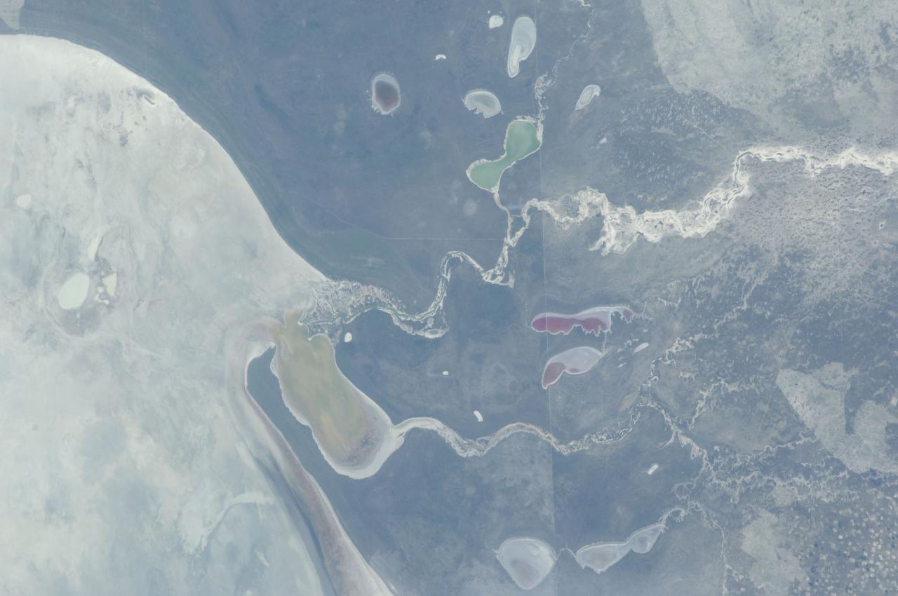
ISS030-E-234965 (30 Dec. 2011) --- The Etosha Pan in Namibia is featured in this image photographed by an Expedition 30 crew member on the International Space Station. This photograph shows the white, salt-covered floor of the northwest corner of the great dry lake in northern Namibia known as the Etosha Pan (left margin). Two rivers, the Ekuma and Oshigambo, transport water from the north down to the Etosha Pan proper. In a relatively rare event, water from recent rains has flowed down the larger Ekuma River?in which it appears as a thin blue line within the generally light grey-green floodplain?and fills a lobe of the lake with light green water (lower right quarter of image). Water has also flowed into a small offshoot dry lake where it appears a brighter green (upper right quarter of image). Other smaller lakes at center and top center show red and brown water colors. The different colors of lake water are determined by the interplay of water depth and resident organisms such as algae; the algae color varies depending on water temperature and salinity. A similar process is observed in pink and red floodwaters ponded in Lake Eyre, a usually dry lake in Australia?s arid center. In this case it is known that the coloration is indeed due to algae growth. Typically, little river water or sediment reaches the floor of the Etosha dry lake because water seeps into the riverbeds along their courses. The floor of the pan itself is seldom seen with even a thin sheet of water. In this image, there was enough surface flow to reach the pan, but too little to flow beyond the inlet bay. A prior flood event, when water entered the pan via the Oshigambo River, was documented in astronaut imagery in 2006. The straight line that crosses the image from top center to bottom is the northern fence line of Namibia?s Etosha National Park. This straight, three-meter-high fence keeps wildlife from crossing into the numerous small farms of the relatively densely populated Owambo region of Namibia, north of the pan. The large Etosha dry lakebed (120 kilometers or 75 miles long) is the center of Namibia?s largest wildlife park, a major tourist attraction.
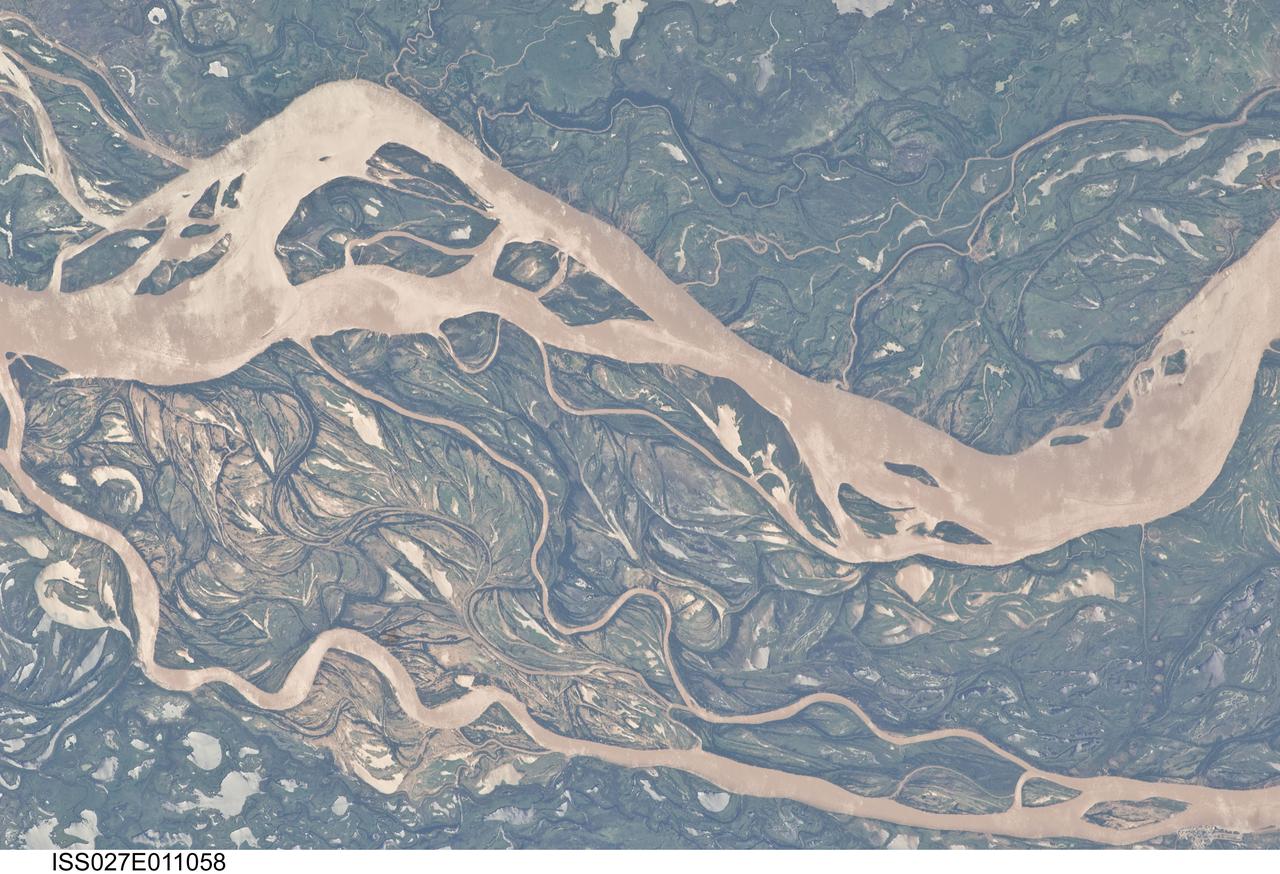
ISS027-E-011058 (9 April 2011) --- The Parana River floodplain in northern Argentina is featured in this image photographed by an Expedition 27 crew member on the International Space Station. This image shows a 29-kilometer stretch of the Parana River, South America?s second largest river, downstream of the small city of Goya (barely distinguishable as grayer surfaces in the extreme top left corner of the image). The Parana River ranges up to three kilometers wide along the reach illustrated in the image. Its strong brown color indicates that it is carrying a heavy load of muddy sediment. Smaller active side channels also carry this muddy water. Numerous lakes are typical on active floodplains, and appear here as irregular bodies of water. Some appear brown, indicating that they have been refilled during recent higher flood levels of the active channels. The main channel Parana River (top) is deep enough to allow smaller ocean-going ships to pass north of the illustrated region to the capital city of Asuncion in landlocked Paraguay, fully 1,200 kilometers inland (well out of the image). The Parana River is thus an important transportation route for landlocked cities such as Asuncion and inland cities of eastern landlocked Bolivia and inland Brazil. The Parana floodplain occupies the entire image; it is so wide?18 kilometers?that its banks are not visible. Numerous curved, or meandering past channels are the most prominent characteristic of the floodplain. These indicate prior positions of rivers. As river beds move laterally by natural processes, they leave remnants of their channels, which appear as lakes, and finally fill with mud. This is an excellent image for illustrating these meander forms. From a geological standpoint it is interesting that almost all the past channels are similar in curvature to the smaller active side rivers; almost no forms show, in any obvious way, prior positions of the main, very wide Parana channel. The reverse might be expected since the main channel is so dominant in the modern landscape.
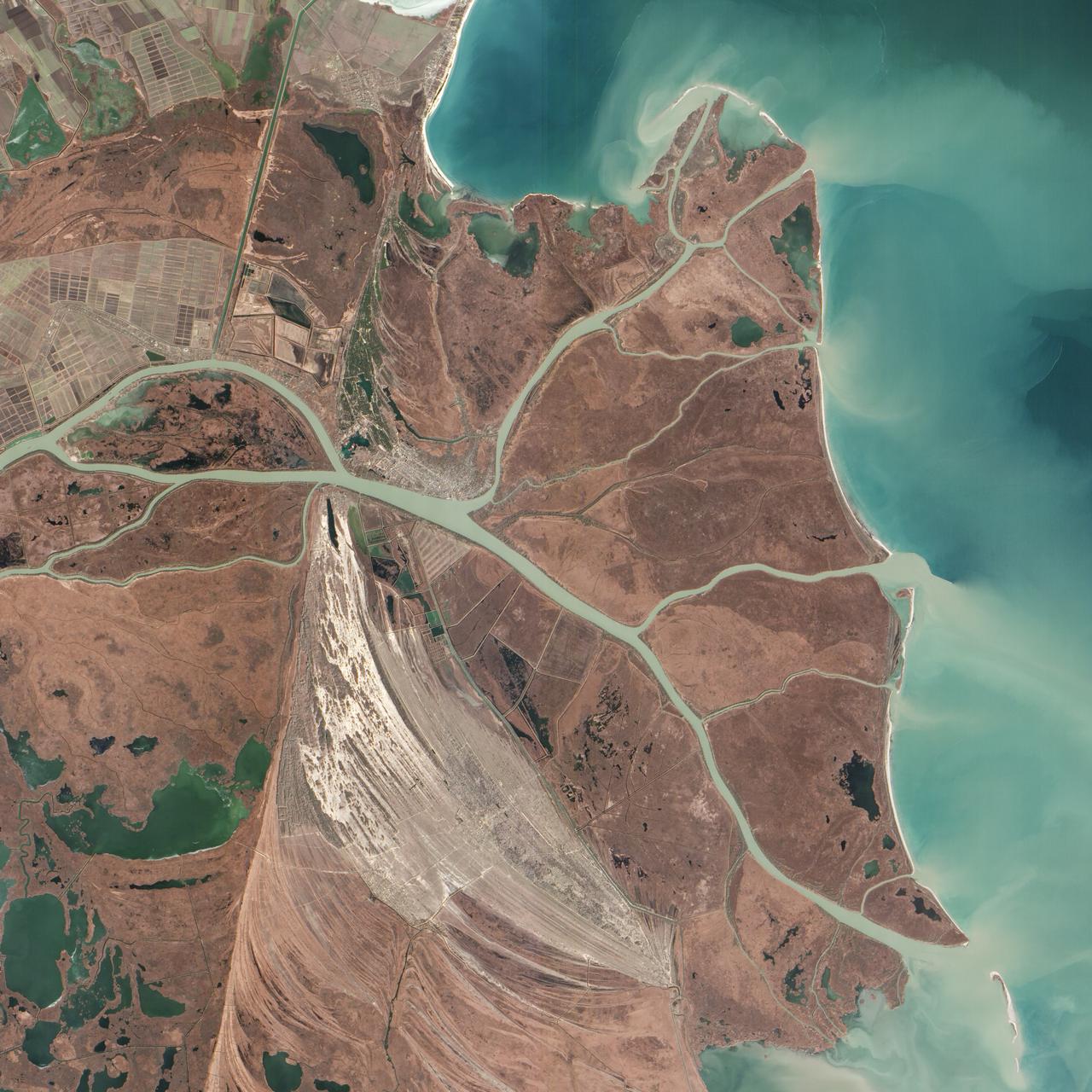
Acquired February 5, 2013 The Danube River is the largest in the European Union, its watershed draining 801,463 square kilometers (309,447 square miles) of land across 19 countries. Where that great river reaches the Black Sea, a remarkable delta has formed—the “Everglades” of Europe. The Danube Delta is home to more than 300 species of bird and 45 species of freshwater fish. The Danube Delta has been home to human settlements since the end of the Stone Age (the Neolithic Period), and the ancient Greeks, Romans, and Byzantines all built trading ports and military outposts along this coast. Today, the border between Romania and Ukraine cuts through the northern part of the delta. The area is a United Nations World Heritage Site, both for its natural and human history, and for the traditional maritime culture that persists in its marshes. All the while, the landscape has been shaped and re-shaped by nature and man. The image above was acquired on February 5, 2013, by the Advanced Land Imager (ALI) on NASA’s Earth Observing-1 (EO-1) satellite. The Danube Delta has a number of lobes formed over the past several thousand years, and this image is focused largely on the northernmost Chilia (or Kilia) lobe. It is the youngest section of the delta—somewhere between 300 to 400 years old—and lies mostly within Ukraine. Much of the land in the image above is officially considered part of the Danube Biosphere Reserve. Near the center of the image, the small city of Vylkove is known as the “Ukranian Venice,” due to its canals. To the lower left, the older Sulina lobe of the delta stretches to the south and further inland into Romania. White and brown curved lines reveal beach ridges and former shorelines, with the whiter ridges composed almost entirely of pure quartz sand in high dunes. To the east of the ridges, most of the landscape is flat marshland that is mostly brown in the barren days of winter. The Bystroye Canal through the center of the Chilia lobe has been the subject of heated debate over the past two decades. Over the centuries, damming and channeling of the Danube throughout Europe has reduced its water flow and sediment load to roughly 30 percent of what it once was, according to coastal geologist Liviu Giosan of the Woods Hole Oceanographic Institution. In recent years, the Ukrainian government has dredged some delta channels (including Bystroye) and proposed extensive dredging of others in order to provide navigational channels for large ships. Proponents argue for the economic needs of water transportation routes. Opponents note that deeper, faster channels mean less mud and sand is deposited in the delta; in some places, more is carried away by swifter currents. Both affect the sensitive ecosystems and the ability of the delta to restore itself and grow. In a 2012 report led by Giosan, scientists noted that the shape, water chemistry, and biology of Danube Delta was being altered long before the modern Industrial Era. Land use practices—particularly farming and forest clearing—added significant amounts of nutrients into the water and reduced salinity in the Black Sea, changing the dominant species of phytoplankton and sending a ripple of effects through the entire food web. NASA Earth Observatory image by Jesse Allen and Robert Simmon, using EO-1 ALI data provided courtesy of the NASA EO-1 team and the U.S. Geological Survey. Caption by Mike Carlowicz. Instrument: EO-1 - ALI More info: <a href="http://earthobservatory.nasa.gov/IOTD/view.php?id=80459" rel="nofollow">earthobservatory.nasa.gov/IOTD/view.php?id=80459</a> Credit: <b><a href="http://www.earthobservatory.nasa.gov/" rel="nofollow"> NASA Earth Observatory</a></b> <b><a href="http://www.nasa.gov/audience/formedia/features/MP_Photo_Guidelines.html" rel="nofollow">NASA image use policy.</a></b> <b><a href="http://www.nasa.gov/centers/goddard/home/index.html" rel="nofollow">NASA Goddard Space Flight Center</a></b> enables NASA’s mission through four scientific endeavors: Earth Science, Heliophysics, Solar System Exploration, and Astrophysics. Goddard plays a leading role in NASA’s accomplishments by contributing compelling scientific knowledge to advance the Agency’s mission. <b>Follow us on <a href="http://twitter.com/NASA_GoddardPix" rel="nofollow">Twitter</a></b> <b>Like us on <a href="http://www.facebook.com/pages/Greenbelt-MD/NASA-Goddard/395013845897?ref=tsd" rel="nofollow">Facebook</a></b> <b>Find us on <a href="http://instagram.com/nasagoddard?vm=grid" rel="nofollow">Instagram</a></b>