
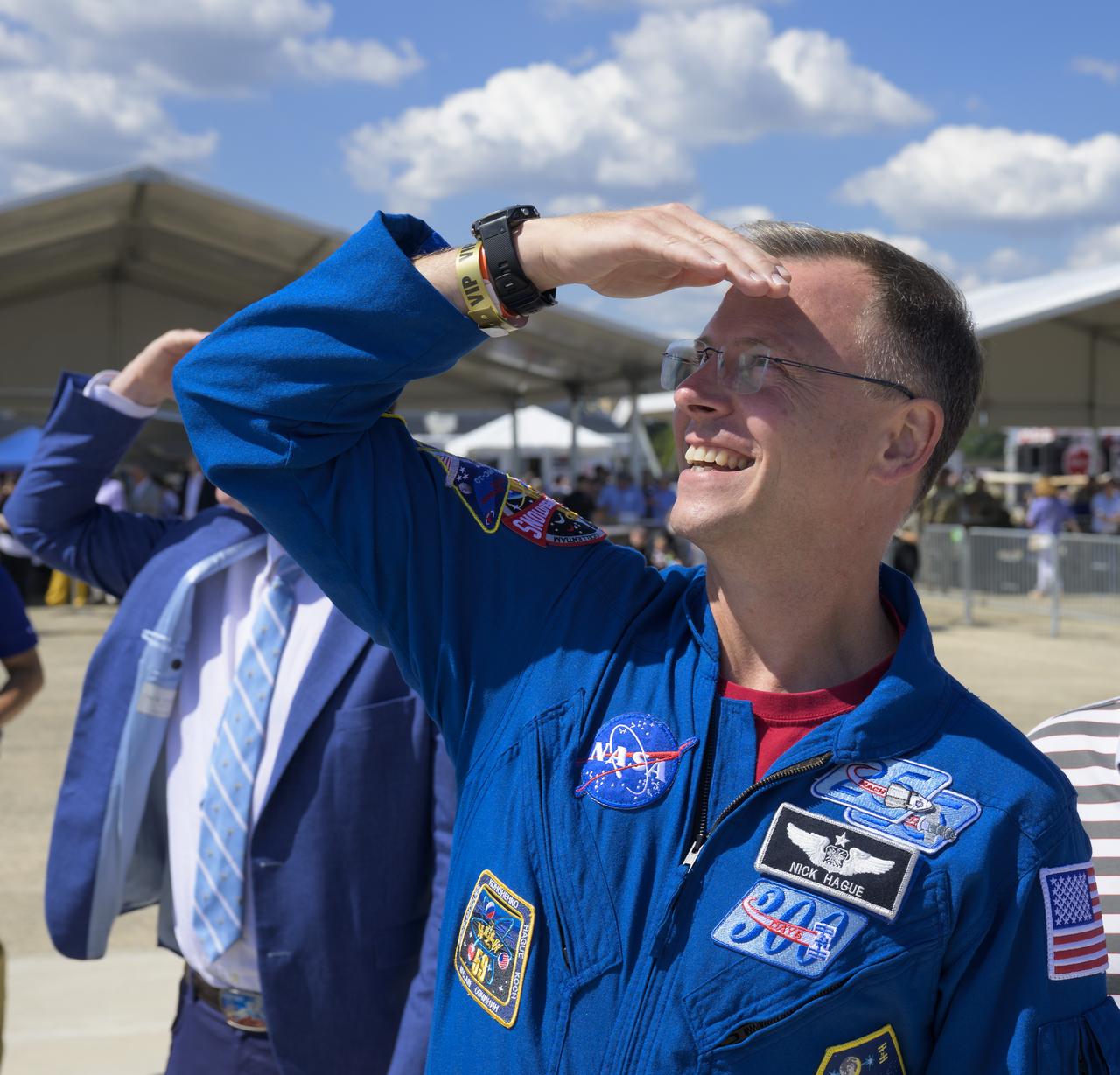
NBC Today Show at Lewis Field
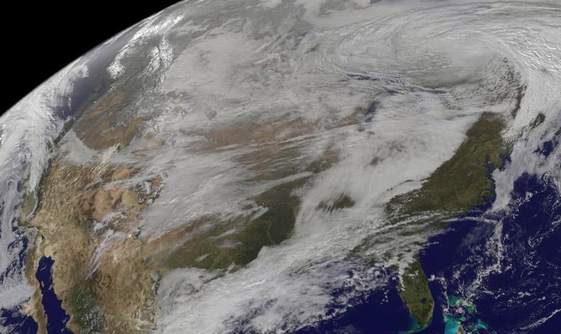
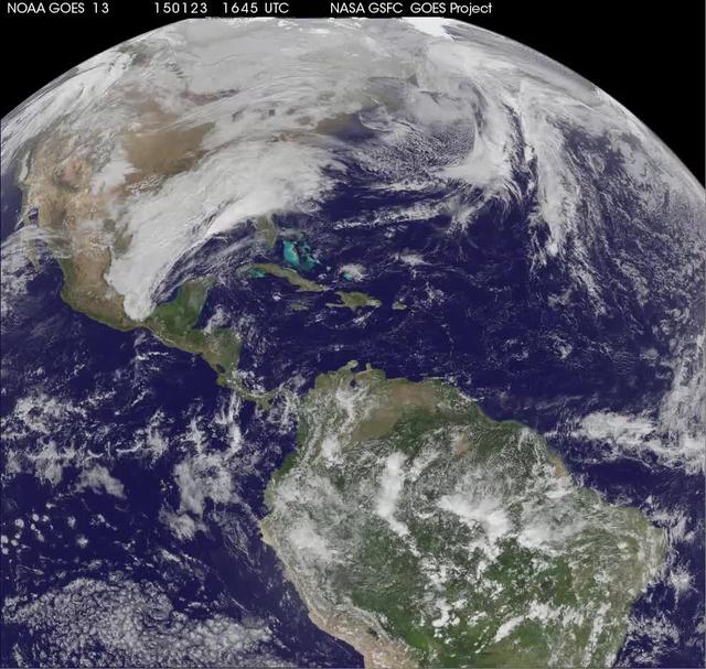
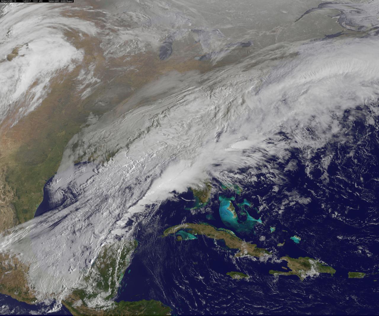
National Weather Service forecasters have been tracking a low pressure area that moved from the Midwest into the Atlantic Ocean today, and is expected to become a strong nor'easter that will bring blizzard conditions to the northeastern U.S. The path of the system was captured in a NASA movie of NOAA's GOES-East satellite imagery. On Monday, January 26, 2015, the National Weather Service noted: A storm system off the East Coast will continue to strengthen as it develops into a major nor'easter on Monday. As the storm moves up the coast, it is expected to bring snowfall of 1-3 feet or more to many parts of the Northeast through Tuesday evening, including New York City and Boston. Strong, gusty winds will combine with the snow to create blizzard conditions along and near the coast. Winter storm warnings are in effect for the panhandles of West Virginia and Maryland, much of interior New England down to the northern Mid-Atlantic as well as for Nantucket Island, Massachusetts. Winter weather advisories are in effect for portions of the Ohio Valley, Mid-Atlantic and the southern Appalachians as well as a narrow area across interior New England. To create the video and imagery, NASA/NOAA's GOES Project located at NASA's Goddard Space Flight Center in Greenbelt, Maryland overlays the cloud data from NOAA's GOES-East satellite on a true-color image of land and ocean created by data from the Moderate Resolution Imaging Spectroradiometer, or MODIS, instrument that flies aboard NASA's Aqua and Terra satellites. Together, these data create the entire animation of the storm and show its movement. GOES satellites provide the kind of continuous monitoring necessary for intensive data analysis. Geostationary describes an orbit in which a satellite is always in the same position with respect to the rotating Earth. This allows GOES to hover continuously over one position on Earth's surface, appearing stationary. As a result, GOES provide a constant vigil for the atmospheric "triggers" for severe weather conditions such as tornadoes, flash floods, hail storms and hurricanes. For updated information about the storm system, visit NOAA's NWS website: <a href="http://www.weather.gov" rel="nofollow">www.weather.gov</a> For more information about GOES satellites, visit: <a href="http://www.goes.noaa.gov/" rel="nofollow">www.goes.noaa.gov/</a> or goes.gsfc.nasa.gov/ Rob Gutro NASA's Goddard Space Flight Center
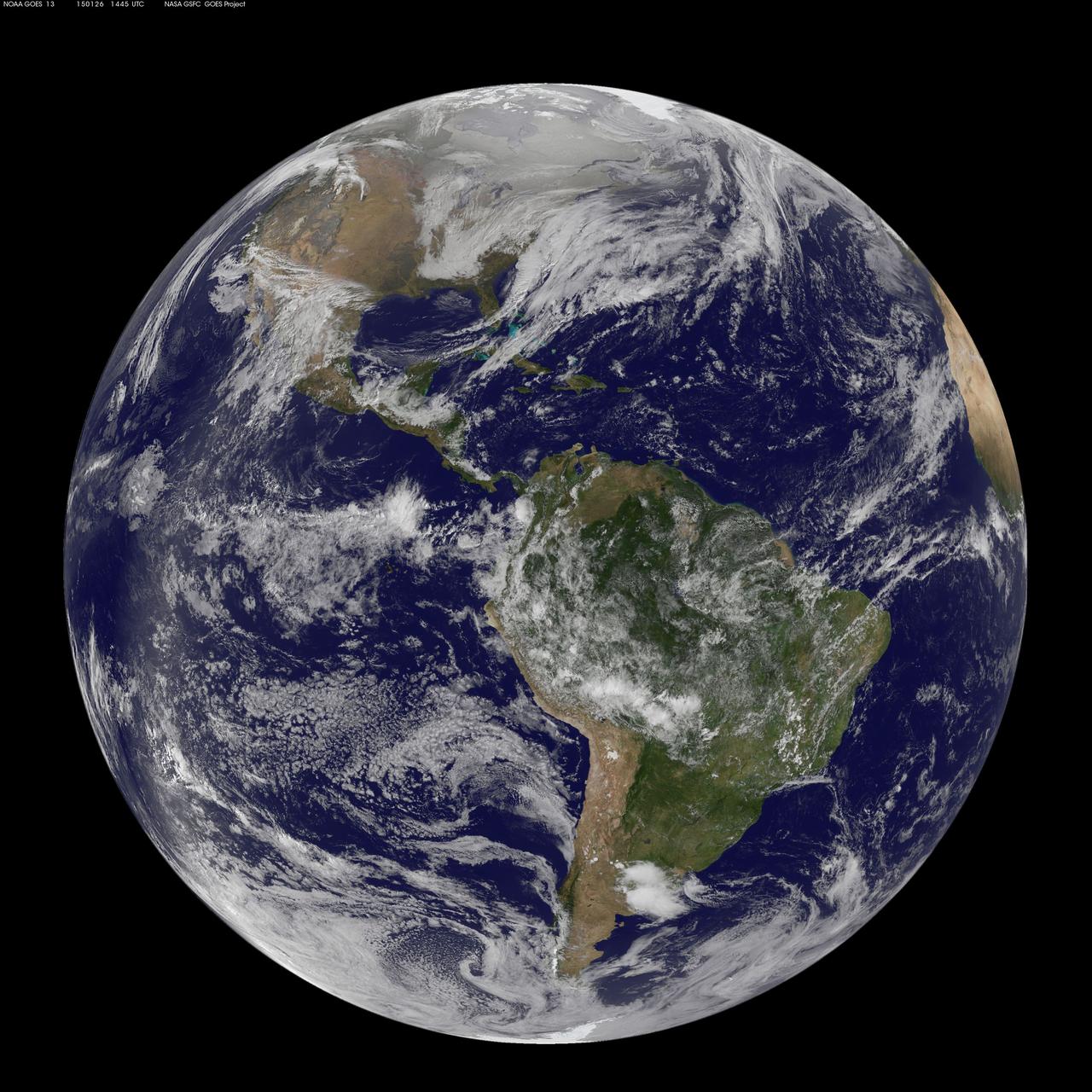
National Weather Service forecasters have been tracking a low pressure area that moved from the Midwest into the Atlantic Ocean today, and is expected to become a strong nor'easter that will bring blizzard conditions to the northeastern U.S. The path of the system was captured in a NASA movie of NOAA's GOES-East satellite imagery. (This GOES 13 image was captured on January 26, 2015 at 1445 UTC.) On Monday, January 26, 2015, the National Weather Service noted: A storm system off the East Coast will continue to strengthen as it develops into a major nor'easter on Monday. As the storm moves up the coast, it is expected to bring snowfall of 1-3 feet or more to many parts of the Northeast through Tuesday evening, including New York City and Boston. Strong, gusty winds will combine with the snow to create blizzard conditions along and near the coast. Winter storm warnings are in effect for the panhandles of West Virginia and Maryland, much of interior New England down to the northern Mid-Atlantic as well as for Nantucket Island, Massachusetts. Winter weather advisories are in effect for portions of the Ohio Valley, Mid-Atlantic and the southern Appalachians as well as a narrow area across interior New England. To create the video and imagery, NASA/NOAA's GOES Project located at NASA's Goddard Space Flight Center in Greenbelt, Maryland overlays the cloud data from NOAA's GOES-East satellite on a true-color image of land and ocean created by data from the Moderate Resolution Imaging Spectroradiometer, or MODIS, instrument that flies aboard NASA's Aqua and Terra satellites. Together, these data create the entire animation of the storm and show its movement. GOES satellites provide the kind of continuous monitoring necessary for intensive data analysis. Geostationary describes an orbit in which a satellite is always in the same position with respect to the rotating Earth. This allows GOES to hover continuously over one position on Earth's surface, appearing stationary. As a result, GOES provide a constant vigil for the atmospheric "triggers" for severe weather conditions such as tornadoes, flash floods, hail storms and hurricanes. For updated information about the storm system, visit NOAA's NWS website: <a href="http://www.weather.gov" rel="nofollow">www.weather.gov</a> For more information about GOES satellites, visit: <a href="http://www.goes.noaa.gov/" rel="nofollow">www.goes.noaa.gov/</a> or goes.gsfc.nasa.gov/ Rob Gutro NASA's Goddard Space Flight Center
On Nov. 12, NOAA's GOES satellite showed the storm system that brought wintry weather entire U.S. centered near Ontario, Canada. Snow is visible in the U.S. and Canadian Rockies. Read more: <a href="http://www.nasa.gov/content/goddard/new-satellite-movie-shows-us-pre-winter-wintry-outbreak/#.VGPP8t6FxgP" rel="nofollow">www.nasa.gov/content/goddard/new-satellite-movie-shows-us...</a> Image Credit: NASA/NOAA GOES Project

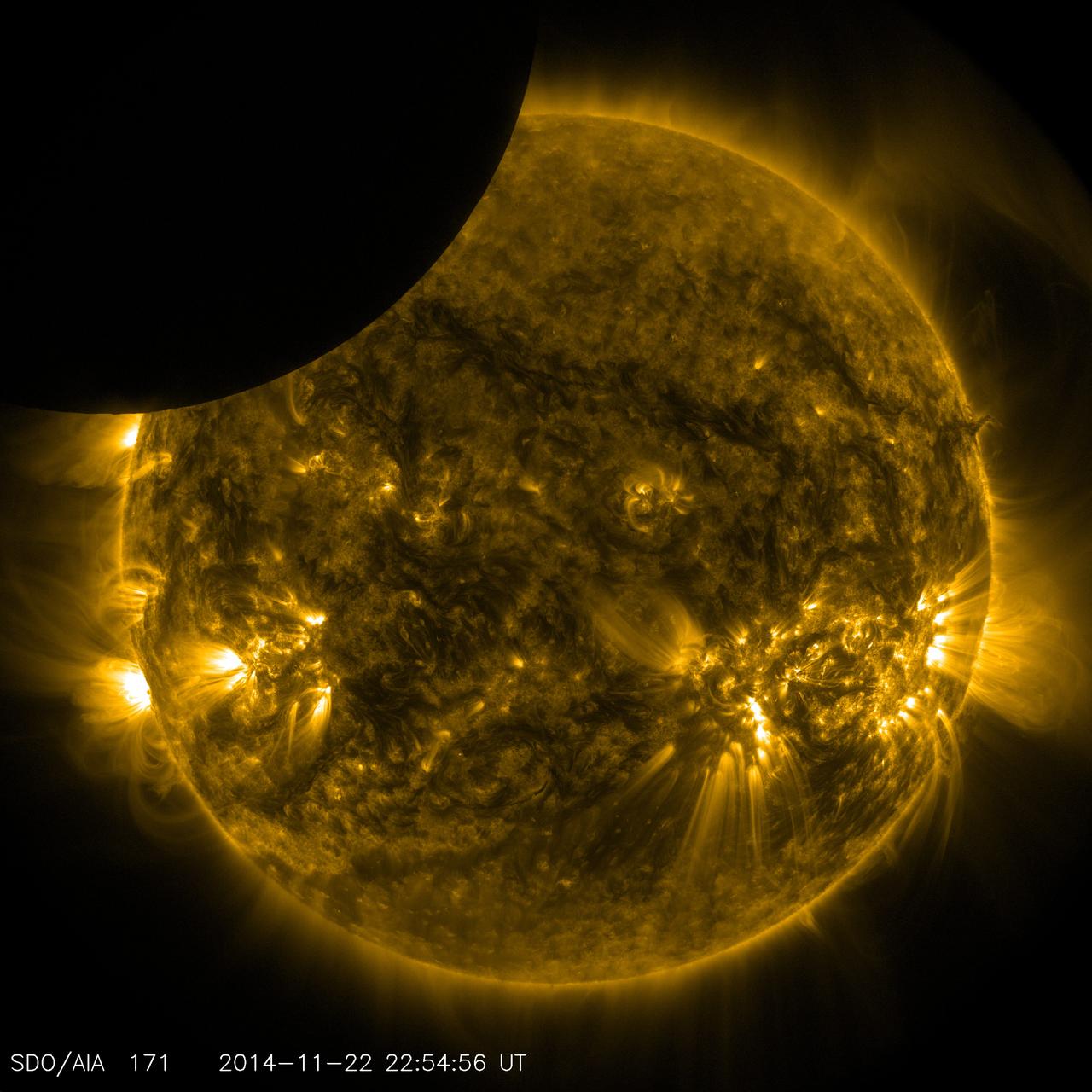
Caption: These SDO images from 7:25 p.m. EST on Feb. 24, 2014, show the first moments of an X-class flare in different wavelengths of light -- seen as the bright spot that appears on the left limb of the sun. Hot solar material can be seen hovering above the active region in the sun's atmosphere, the corona. Credit: NASA/SDO More info: The sun emitted a significant solar flare, peaking at 7:49 p.m. EST on Feb. 24, 2014. NASA's Solar Dynamics Observatory, which keeps a constant watch on the sun, captured images of the event. Solar flares are powerful bursts of radiation, appearing as giant flashes of light in the SDO images. Harmful radiation from a flare cannot pass through Earth's atmosphere to physically affect humans on the ground, however -- when intense enough -- they can disturb the atmosphere in the layer where GPS and communications signals travel. This flare is classified as an X4.9-class flare. X-class denotes the most intense flares, while the number provides more information about its strength. An X2 is twice as intense as an X1, an X3 is three times as intense, etc. <b><a href="http://www.nasa.gov/audience/formedia/features/MP_Photo_Guidelines.html" rel="nofollow">NASA image use policy.</a></b> <b><a href="http://www.nasa.gov/centers/goddard/home/index.html" rel="nofollow">NASA Goddard Space Flight Center</a></b> enables NASA’s mission through four scientific endeavors: Earth Science, Heliophysics, Solar System Exploration, and Astrophysics. Goddard plays a leading role in NASA’s accomplishments by contributing compelling scientific knowledge to advance the Agency’s mission. <b>Follow us on <a href="http://twitter.com/NASAGoddardPix" rel="nofollow">Twitter</a></b> <b>Like us on <a href="http://www.facebook.com/pages/Greenbelt-MD/NASA-Goddard/395013845897?ref=tsd" rel="nofollow">Facebook</a></b> <b>Find us on <a href="http://instagram.com/nasagoddard?vm=grid" rel="nofollow">Instagram</a></b>

Caption: These SDO images from 7:25 p.m. EST on Feb. 24, 2014, show the first moments of an X-class flare in different wavelengths of light -- seen as the bright spot that appears on the left limb of the sun. Hot solar material can be seen hovering above the active region in the sun's atmosphere, the corona. Credit: NASA/SDO More info: The sun emitted a significant solar flare, peaking at 7:49 p.m. EST on Feb. 24, 2014. NASA's Solar Dynamics Observatory, which keeps a constant watch on the sun, captured images of the event. Solar flares are powerful bursts of radiation, appearing as giant flashes of light in the SDO images. Harmful radiation from a flare cannot pass through Earth's atmosphere to physically affect humans on the ground, however -- when intense enough -- they can disturb the atmosphere in the layer where GPS and communications signals travel. This flare is classified as an X4.9-class flare. X-class denotes the most intense flares, while the number provides more information about its strength. An X2 is twice as intense as an X1, an X3 is three times as intense, etc. <b><a href="http://www.nasa.gov/audience/formedia/features/MP_Photo_Guidelines.html" rel="nofollow">NASA image use policy.</a></b> <b><a href="http://www.nasa.gov/centers/goddard/home/index.html" rel="nofollow">NASA Goddard Space Flight Center</a></b> enables NASA’s mission through four scientific endeavors: Earth Science, Heliophysics, Solar System Exploration, and Astrophysics. Goddard plays a leading role in NASA’s accomplishments by contributing compelling scientific knowledge to advance the Agency’s mission. <b>Follow us on <a href="http://twitter.com/NASAGoddardPix" rel="nofollow">Twitter</a></b> <b>Like us on <a href="http://www.facebook.com/pages/Greenbelt-MD/NASA-Goddard/395013845897?ref=tsd" rel="nofollow">Facebook</a></b> <b>Find us on <a href="http://instagram.com/nasagoddard?vm=grid" rel="nofollow">Instagram</a></b>

Caption: An X-class solar flare erupted on the left side of the sun on the evening of Feb. 24, 2014. This composite image, captured at 7:59 p.m. EST, shows the sun in X-ray light with wavelengths of both 131 and 171 angstroms. Credit: NASA/SDO More info: The sun emitted a significant solar flare, peaking at 7:49 p.m. EST on Feb. 24, 2014. NASA's Solar Dynamics Observatory, which keeps a constant watch on the sun, captured images of the event. Solar flares are powerful bursts of radiation, appearing as giant flashes of light in the SDO images. Harmful radiation from a flare cannot pass through Earth's atmosphere to physically affect humans on the ground, however -- when intense enough -- they can disturb the atmosphere in the layer where GPS and communications signals travel. This flare is classified as an X4.9-class flare. X-class denotes the most intense flares, while the number provides more information about its strength. An X2 is twice as intense as an X1, an X3 is three times as intense, etc. <b><a href="http://www.nasa.gov/audience/formedia/features/MP_Photo_Guidelines.html" rel="nofollow">NASA image use policy.</a></b> <b><a href="http://www.nasa.gov/centers/goddard/home/index.html" rel="nofollow">NASA Goddard Space Flight Center</a></b> enables NASA’s mission through four scientific endeavors: Earth Science, Heliophysics, Solar System Exploration, and Astrophysics. Goddard plays a leading role in NASA’s accomplishments by contributing compelling scientific knowledge to advance the Agency’s mission. <b>Follow us on <a href="http://twitter.com/NASAGoddardPix" rel="nofollow">Twitter</a></b> <b>Like us on <a href="http://www.facebook.com/pages/Greenbelt-MD/NASA-Goddard/395013845897?ref=tsd" rel="nofollow">Facebook</a></b> <b>Find us on <a href="http://instagram.com/nasagoddard?vm=grid" rel="nofollow">Instagram</a></b>
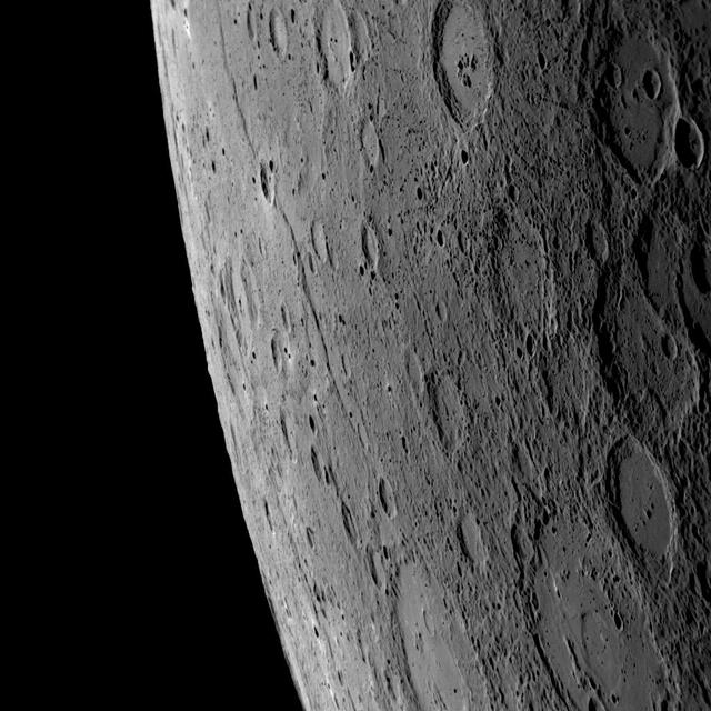
Mercury Shows Signs of Aging
Rocky Hollow Picture Show
Stretched View Showing Victoria
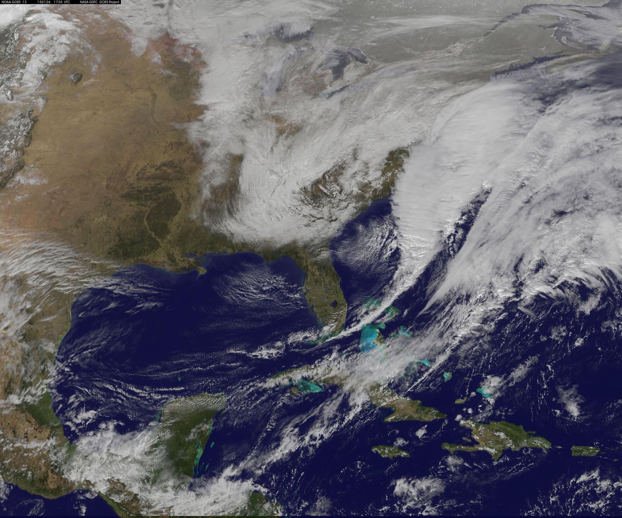
National Weather Service forecasters have been tracking a low pressure area that moved from the Midwest into the Atlantic Ocean today, and is expected to become a strong nor'easter that will bring blizzard conditions to the northeastern U.S. The path of the system was captured in a NASA movie of NOAA's GOES-East satellite imagery. An animation of visible and infrared imagery from NOAA's Geostationary Operational Environmental or GOES satellite captured over the period of January 24 through 26 showed the progression of the developing nor'easter. The satellite animation began on Jan. 24 when clouds associated with a cold front preceding the low, pushed off the U.S. East coast. The front was followed by a low pressure area that moved from the Midwest to the southeast. That low moved over the Carolinas and exited into the Atlantic Ocean on Jan. 26. NOAA's National Weather Service forecast calls for the low to intensify along the Eastern Seaboard and bring blizzard conditions to the northeastern U.S. on Monday night, January 26 and Tuesday, January 27. On Monday, January 26, 2015, the National Weather Service noted: A storm system off the East Coast will continue to strengthen as it develops into a major nor'easter on Monday. As the storm moves up the coast, it is expected to bring snowfall of 1-3 feet or more to many parts of the Northeast through Tuesday evening, including New York City and Boston. Strong, gusty winds will combine with the snow to create blizzard conditions along and near the coast. Winter storm warnings are in effect for the panhandles of West Virginia and Maryland, much of interior New England down to the northern Mid-Atlantic as well as for Nantucket Island, Massachusetts. Winter weather advisories are in effect for portions of the Ohio Valley, Mid-Atlantic and the southern Appalachians as well as a narrow area across interior New England. To create the video and imagery, NASA/NOAA's GOES Project located at NASA's Goddard Space Flight Center in Greenbelt, Maryland overlays the cloud data from NOAA's GOES-East satellite on a true-color image of land and ocean created by data from the Moderate Resolution Imaging Spectroradiometer, or MODIS, instrument that flies aboard NASA's Aqua and Terra satellites. Together, these data create the entire animation of the storm and show its movement. GOES satellites provide the kind of continuous monitoring necessary for intensive data analysis. Geostationary describes an orbit in which a satellite is always in the same position with respect to the rotating Earth. This allows GOES to hover continuously over one position on Earth's surface, appearing stationary. As a result, GOES provide a constant vigil for the atmospheric "triggers" for severe weather conditions such as tornadoes, flash floods, hail storms and hurricanes. For updated information about the storm system, visit NOAA's NWS website: <a href="http://www.weather.gov" rel="nofollow">www.weather.gov</a> For more information about GOES satellites, visit: <a href="http://www.goes.noaa.gov/" rel="nofollow">www.goes.noaa.gov/</a> or goes.gsfc.nasa.gov/ Rob Gutro NASA's Goddard Space Flight Center

The greens and blues of the ocean color from NASA satellite data have provided new insights into how climate and ecosystem processes affect the growth cycles of phytoplankton—microscopic aquatic plants important for fish populations and Earth’s carbon cycle. At the bottom of the ocean’s food chain, phytoplankton account for roughly half of the net photosynthesis on Earth. Their photosynthesis consumes carbon dioxide and plays a key role in transferring carbon from the atmosphere to the ocean. Unlike the plant ecosystems on land, the amount of phytoplankton in the ocean is always followed closely by the abundance of organisms that eat phytoplankton, creating a perpetual dance between predators and prey. This new analysis shows how tiny imbalances in this predator-prey relationship, caused by environmental variability, give rise to massive phytoplankton blooms, having huge impacts on ocean productivity, fisheries and carbon cycling. The study was released Thursday, Sept. 25, in the journal Nature Climate Change. “The continuous year-in and year-out measurements provided by NASA’s ocean color satellites have dramatically changed our understanding of phytoplankton dynamics on the Earth,” said Mike Behrenfeld, author of the study and phytoplankton ecologist at Oregon State University, Corvallis, Oregon. “What we now see is a closely linked system of phytoplankton cell division and consumption lying at the heart of the plant’s annual cycle.” Behrenfeld calls this close predator-prey relationship the “Dance of the Plankton.” This view is different from previous perspectives that have simply focused on environmental resources used by phytoplankton to grow, such as nutrients and light. The new view is important because it reveals that tiny imbalances can greatly impact Earth’s ecology. Read more: <a href="http://1.usa.gov/ZkVMHG" rel="nofollow">1.usa.gov/ZkVMHG</a> Credit: NASA's Goddard Space Flight Center, Norman Kuring; USGS <b><a href="http://www.nasa.gov/audience/formedia/features/MP_Photo_Guidelines.html" rel="nofollow">NASA image use policy.</a></b> <b><a href="http://www.nasa.gov/centers/goddard/home/index.html" rel="nofollow">NASA Goddard Space Flight Center</a></b> enables NASA’s mission through four scientific endeavors: Earth Science, Heliophysics, Solar System Exploration, and Astrophysics. Goddard plays a leading role in NASA’s accomplishments by contributing compelling scientific knowledge to advance the Agency’s mission. <b>Follow us on <a href="http://twitter.com/NASAGoddardPix" rel="nofollow">Twitter</a></b> <b>Like us on <a href="http://www.facebook.com/pages/Greenbelt-MD/NASA-Goddard/395013845897?ref=tsd" rel="nofollow">Facebook</a></b> <b>Find us on <a href="http://instagram.com/nasagoddard?vm=grid" rel="nofollow">Instagram</a></b>

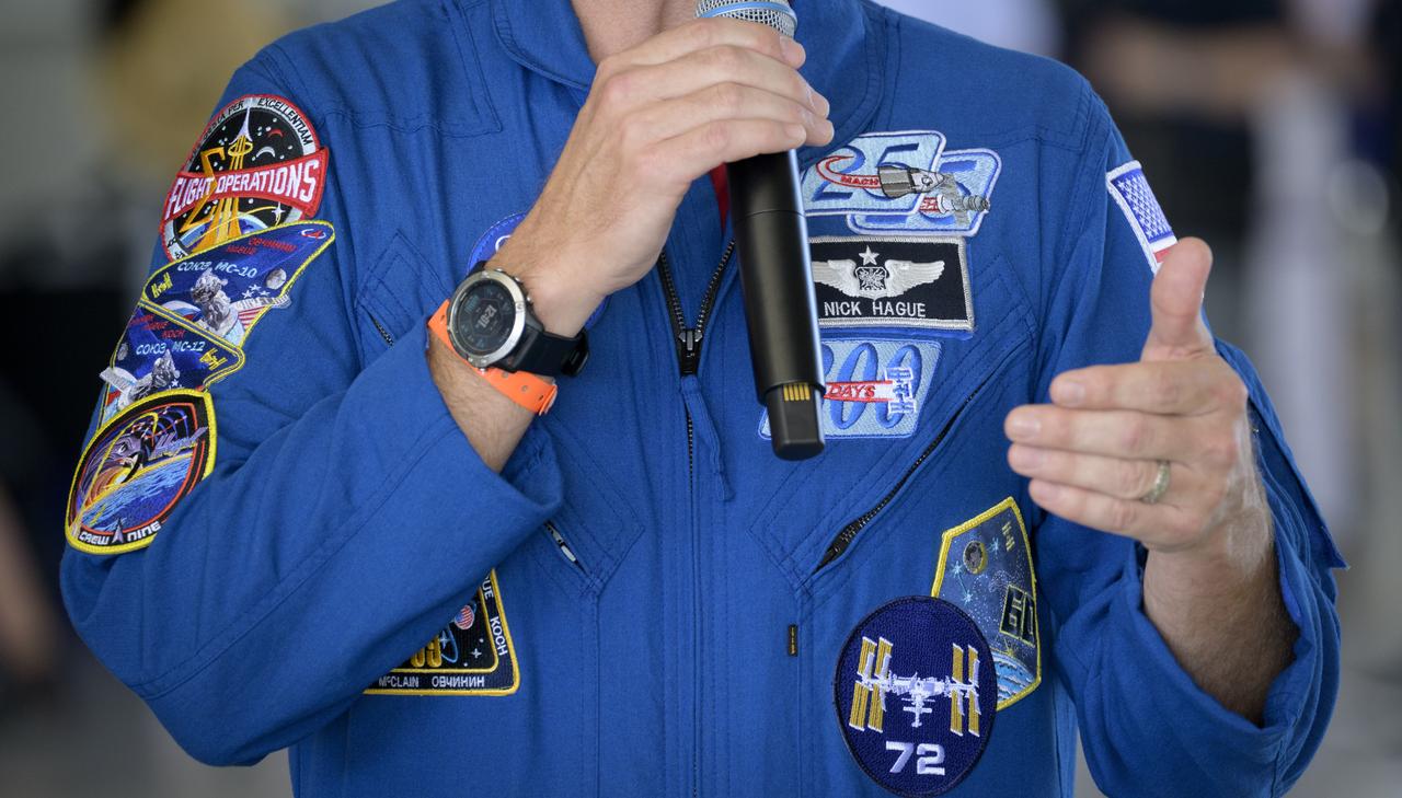
A young spectator watches a U.S. Navy F/A-15F Super Hornet jet fly, Friday, Sept. 12, 2025, during the Joint Base Andrews Air Show at Joint Base Andrews in Prince George's County, Maryland. NASA astronaut Nick Hague was on hand to provide remarks and meet with guests. Hague spent 171 days onboard the International Space Station as part of Expedition 72. Photo Credit: (NASA/Bill Ingalls)

The F-22 and the classic P-38 shares the sky at the Los Angeles County Air Show in Lancaster, California.

NASA Armstrong pilots Stu Broce, Greg Nelson and Tim Williams sign autographs for people at the Los Angeles County Air Show in Lancaster, California.

A young woman tries her hand at “piloting” a high-performance jet. The representation of a jet cockpit is a popular display at NASA Armstrong-supported air shows and festivals across the nation.
Phoenix Scoop Inverted Showing Rasp

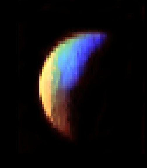
Mercury Shows its True Colors
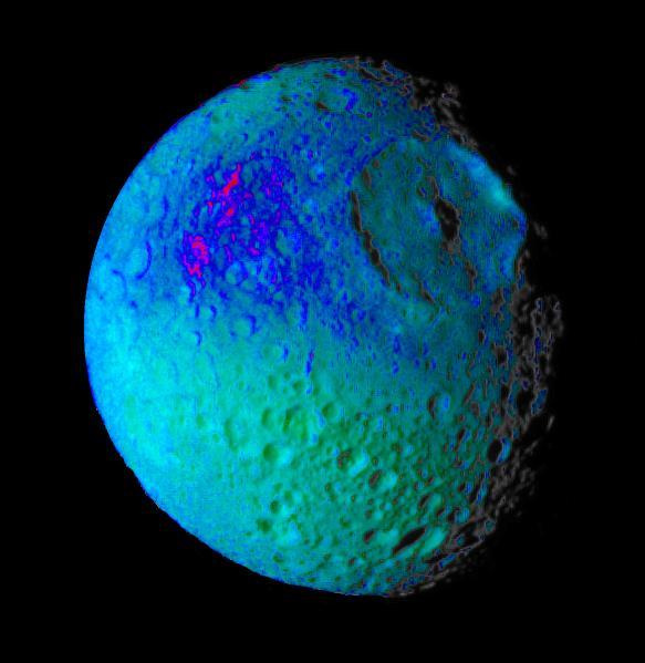
Mimas Showing False Colors #2
VIMS Shows Iapetus Surface Composition

Ultraviolet View Shows Jupiter Stratosphere
Magic Carpet Shows Its Colors
Stretched View Showing Beagle Crater

Radar Shows Titan Live and in Color
Windtails Show Direction of Martian Winds
On April 9, 2013 at 11:52 GMT, a magnitude 6.3 earthquake hit southwestern Iran's Bushehr province near the town of Kaki. Preliminary information is that several villages have been destroyed and many people have died, as reported by BBC News. This perspective view of the region was acquired Nov. 17, 2012, by the Advanced Spaceborne Thermal Emission and Reflection Radiometer (ASTER) instrument on NASA's Terra spacecraft. The location of the earthquake's epicenter is marked with a yellow star. Vegetation is displayed in red; the vertical exaggeration of the topography is 2X. The image is centered near 28.5 degrees north latitude, 51.6 degrees east longitude. With its 14 spectral bands from the visible to the thermal infrared wavelength region and its high spatial resolution of 15 to 90 meters (about 50 to 300 feet), ASTER images Earth to map and monitor the changing surface of our planet. ASTER is one of five Earth-observing instruments launched Dec. 18, 1999, on Terra. The instrument was built by Japan's Ministry of Economy, Trade and Industry. A joint U.S./Japan science team is responsible for validation and calibration of the instrument and data products. The broad spectral coverage and high spectral resolution of ASTER provides scientists in numerous disciplines with critical information for surface mapping and monitoring of dynamic conditions and temporal change. Example applications are: monitoring glacial advances and retreats; monitoring potentially active volcanoes; identifying crop stress; determining cloud morphology and physical properties; wetlands evaluation; thermal pollution monitoring; coral reef degradation; surface temperature mapping of soils and geology; and measuring surface heat balance. The U.S. science team is located at NASA's Jet Propulsion Laboratory, Pasadena, Calif. The Terra mission is part of NASA's Science Mission Directorate, Washington, D.C. More information about ASTER is available at <a href="http://asterweb.jpl.nasa.gov/" rel="nofollow">asterweb.jpl.nasa.gov/</a>. Image Credit: NASA/GSFC/METI/ERSDAC/JAROS, and U.S./Japan ASTER Science Team Image Addition Date: 2013-04-10 <b><a href="http://www.nasa.gov/audience/formedia/features/MP_Photo_Guidelines.html" rel="nofollow">NASA image use policy.</a></b> <b><a href="http://www.nasa.gov/centers/goddard/home/index.html" rel="nofollow">NASA Goddard Space Flight Center</a></b> enables NASA’s mission through four scientific endeavors: Earth Science, Heliophysics, Solar System Exploration, and Astrophysics. Goddard plays a leading role in NASA’s accomplishments by contributing compelling scientific knowledge to advance the Agency’s mission. <b>Follow us on <a href="http://twitter.com/NASA_GoddardPix" rel="nofollow">Twitter</a></b> <b>Like us on <a href="http://www.facebook.com/pages/Greenbelt-MD/NASA-Goddard/395013845897?ref=tsd" rel="nofollow">Facebook</a></b> <b>Find us on <a href="http://instagram.com/nasagoddard?vm=grid" rel="nofollow">Instagram</a></b>
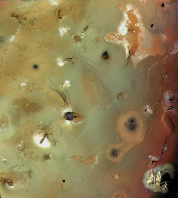
Io, Showing Volcanic Plains and Mountains http://photojournal.jpl.nasa.gov/catalog/PIA00328
NASA astronaut Nick Hague meets with attendees, Friday, Sept. 12, 2025, during the Joint Base Andrews Air Show at Joint Base Andrews in Prince George's County, Maryland. Hague spent 171 days onboard the International Space Station as part of Expedition 72. Photo Credit: (NASA/Bill Ingalls)

NASA astronaut Nick Hague meets with attendees, Friday, Sept. 12, 2025, during the Joint Base Andrews Air Show at Joint Base Andrews in Prince George's County, Maryland. Hague spent 171 days onboard the International Space Station as part of Expedition 72. Photo Credit: (NASA/Bill Ingalls)
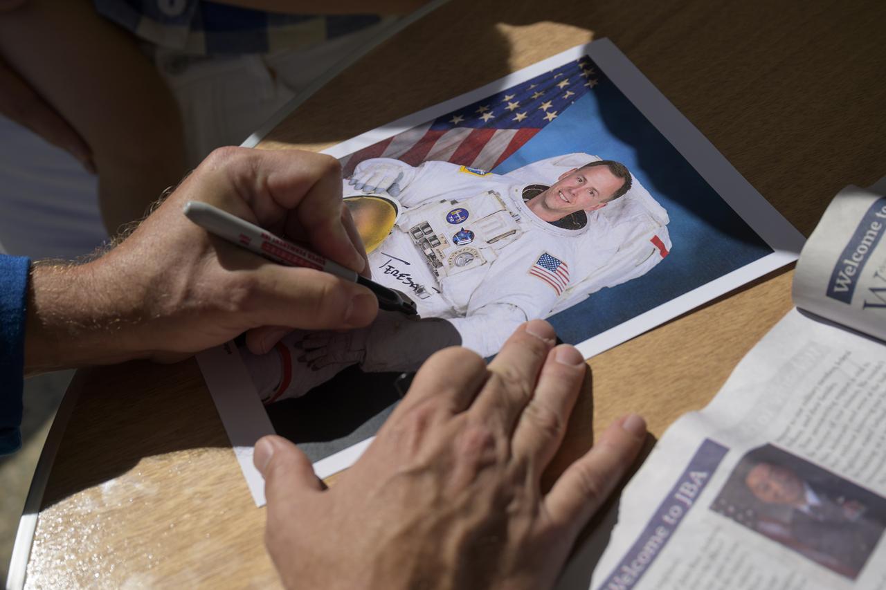
NASA astronaut Nick Hague signs autographs, Friday, Sept. 12, 2025, during the Joint Base Andrews Air Show at Joint Base Andrews in Prince George's County, Maryland. Hague spent 171 days onboard the International Space Station as part of Expedition 72. Photo Credit: (NASA/Bill Ingalls)
NASA astronaut Nick Hague meets with attendees, Friday, Sept. 12, 2025, during the Joint Base Andrews Air Show at Joint Base Andrews in Prince George's County, Maryland. Hague spent 171 days onboard the International Space Station as part of Expedition 72. Photo Credit: (NASA/Bill Ingalls)

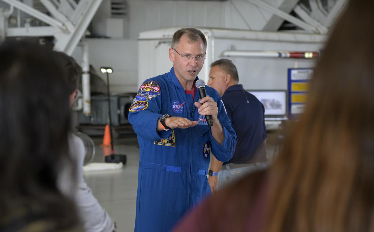
NASA astronaut Nick Hague gives remarks, Friday, Sept. 12, 2025, during the Joint Base Andrews Air Show at Joint Base Andrews in Prince George's County, Maryland. Hague spent 171 days onboard the International Space Station as part of Expedition 72. Photo Credit: (NASA/Bill Ingalls)

NASA astronaut Nick Hague meets with attendees, Friday, Sept. 12, 2025, during the Joint Base Andrews Air Show at Joint Base Andrews in Prince George's County, Maryland. Hague spent 171 days onboard the International Space Station as part of Expedition 72. Photo Credit: (NASA/Bill Ingalls)
NASA astronaut Nick Hague meets with attendees, Friday, Sept. 12, 2025, during the Joint Base Andrews Air Show at Joint Base Andrews in Prince George's County, Maryland. Hague spent 171 days onboard the International Space Station as part of Expedition 72. Photo Credit: (NASA/Bill Ingalls)

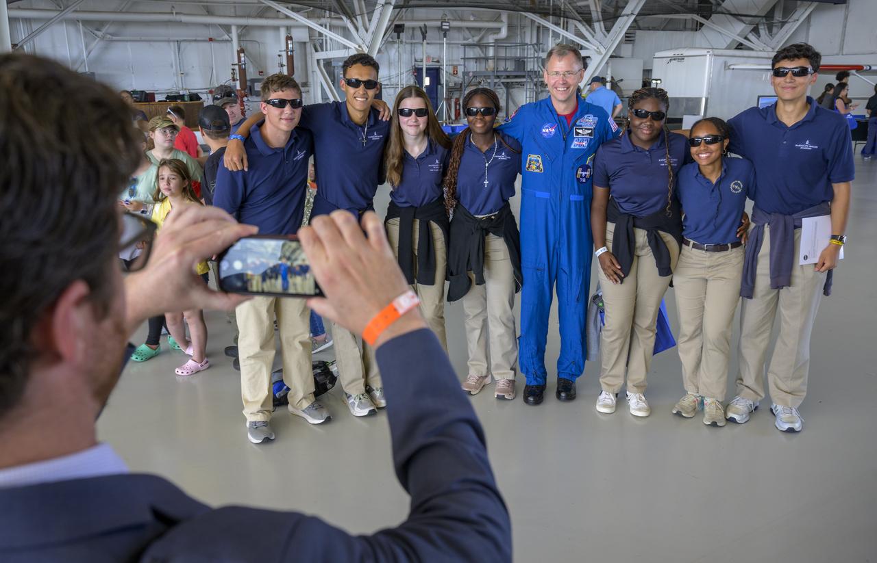
NASA astronaut Nick Hague meets with attendees, Friday, Sept. 12, 2025, during the Joint Base Andrews Air Show at Joint Base Andrews in Prince George's County, Maryland. Hague spent 171 days onboard the International Space Station as part of Expedition 72. Photo Credit: (NASA/Bill Ingalls)
NASA astronaut Nick Hague meets with attendees, Friday, Sept. 12, 2025, during the Joint Base Andrews Air Show at Joint Base Andrews in Prince George's County, Maryland. Hague spent 171 days onboard the International Space Station as part of Expedition 72. Photo Credit: (NASA/Bill Ingalls)
NASA astronaut Nick Hague meets with attendees, Friday, Sept. 12, 2025, during the Joint Base Andrews Air Show at Joint Base Andrews in Prince George's County, Maryland. Hague spent 171 days onboard the International Space Station as part of Expedition 72. Photo Credit: (NASA/Bill Ingalls)

NASA astronaut Nick Hague meets with attendees, Friday, Sept. 12, 2025, during the Joint Base Andrews Air Show at Joint Base Andrews in Prince George's County, Maryland. Hague spent 171 days onboard the International Space Station as part of Expedition 72. Photo Credit: (NASA/Bill Ingalls)
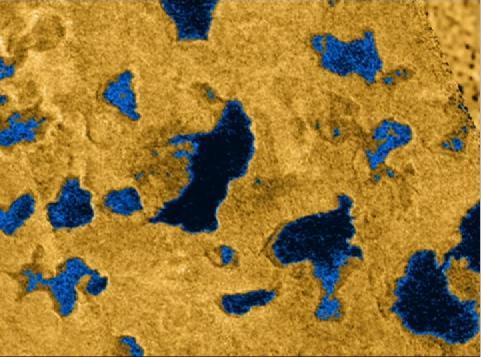
This movie, comprised of several detailed images taken by Cassini radar instrument, shows bodies of liquid near Titan north pole. These images show that many of the features commonly associated with lakes on Earth
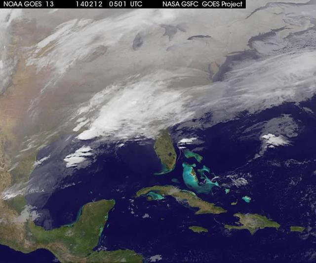
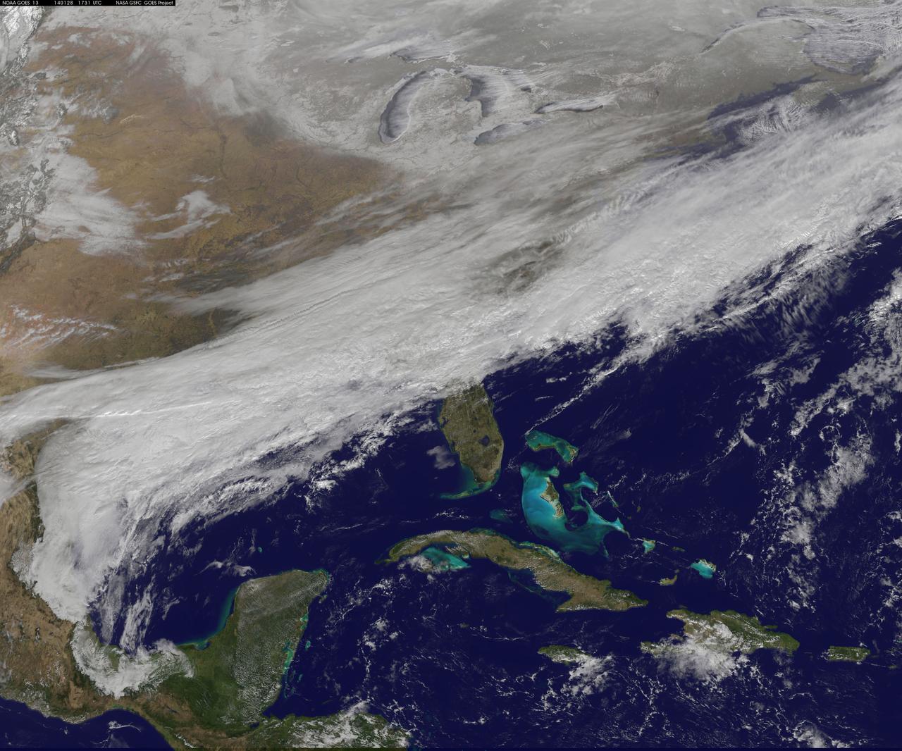
A new NASA video of NOAA's GOES satellite imagery shows three days of movement of the massive winter storm that stretches from the southern U.S. to the northeast. Visible and infrared imagery from NOAA's GOES-East or GOES-13 satellite from Feb. 10 at 1815 UTC/1:15 p.m. EST to Feb. 12 to 1845 UTC/1:45 p.m. EST were compiled into a video made by NASA/NOAA's GOES Project at NASA's Goddard Space Flight Center in Greenbelt, Md. In the video, viewers can see the development and movement of the clouds associated with the progression of the frontal system and related low pressure areas that make up the massive storm. The video also shows the snow covered ground over the Great Lakes region and Ohio Valley that stretches to northern New England. The clouds and fallen snow data from NOAA's GOES-East satellite were overlaid on a true-color image of land and ocean created by data from the Moderate Resolution Imaging Spectroradiometer or MODIS instrument that flies aboard NASA's Aqua and Terra satellites. On February 12 at 10 a.m. EST, NOAA's National Weather Service or NWS continued to issue watches and warnings from Texas to New England. Specifically, NWS cited Winter Storm Warnings and Winter Weather Advisories were in effect from eastern Texas eastward across the interior section of southeastern U.S. states and across much of the eastern seaboard including the Appalachians. Winter storm watches are in effect for portions of northern New England as well as along the western slopes of northern and central Appalachians. For updates on local forecasts, watches and warnings, visit NOAA's <a href="http://www.weather.gov" rel="nofollow">www.weather.gov</a> webpage. NOAA's Weather Prediction Center or WPC noted the storm is expected to bring "freezing rain spreading into the Carolinas, significant snow accumulations are expected in the interior Mid-Atlantic states tonight into Thursday and ice storm warnings and freezing rain advisories are in effect across much of central Georgia. GOES satellites provide the kind of continuous monitoring necessary for intensive data analysis. Geostationary describes an orbit in which a satellite is always in the same position with respect to the rotating Earth. This allows GOES to hover continuously over one position on Earth's surface, appearing stationary. As a result, GOES provide a constant vigil for the atmospheric "triggers" for severe weather conditions such as tornadoes, flash floods, hail storms and hurricanes. For updated information about the storm system, visit NOAA's WPC website; <a href="http://www.hpc.ncep.noaa.gov/" rel="nofollow">www.hpc.ncep.noaa.gov/</a> For more information about GOES satellites, visit: <a href="http://www.goes.noaa.gov/" rel="nofollow">www.goes.noaa.gov/</a> or <a href="http://goes.gsfc.nasa.gov/" rel="nofollow">goes.gsfc.nasa.gov/</a> Rob Gutro NASA's Goddard Space Flight Center <b><a href="http://goes.gsfc.nasa.gov/" rel="nofollow">Credit: NOAA/NASA GOES Project</a></b> <b><a href="http://www.nasa.gov/audience/formedia/features/MP_Photo_Guidelines.html" rel="nofollow">NASA image use policy.</a></b> <b><a href="http://www.nasa.gov/centers/goddard/home/index.html" rel="nofollow">NASA Goddard Space Flight Center</a></b> enables NASA’s mission through four scientific endeavors: Earth Science, Heliophysics, Solar System Exploration, and Astrophysics. Goddard plays a leading role in NASA’s accomplishments by contributing compelling scientific knowledge to advance the Agency’s mission. <b>Follow us on <a href="http://twitter.com/NASAGoddardPix" rel="nofollow">Twitter</a></b> <b>Like us on <a href="http://www.facebook.com/pages/Greenbelt-MD/NASA-Goddard/395013845897?ref=tsd" rel="nofollow">Facebook</a></b> <b>Find us on <a href="http://instagrid.me/nasagoddard/?vm=grid" rel="nofollow">Instagram</a></b>

The United States Army Parachute Team, the Golden Knights, are seen during the opening ceremony of the Joint Base Andrews Air Show, Friday, Sept. 12, 2025, at Joint Base Andrews in Prince George's County, Maryland. NASA astronaut Nick Hague was on hand to provide remarks and meet with guests. Hague spent 171 days onboard the International Space Station as part of Expedition 72. Photo Credit: (NASA/Bill Ingalls)

NASA astronaut Nick Hague talks with members of the Civil Air Patrol, Friday, Sept. 12, 2025, during the Joint Base Andrews Air Show at Joint Base Andrews in Prince George's County, Maryland. Hague spent 171 days onboard the International Space Station as part of Expedition 72. Photo Credit: (NASA/Bill Ingalls)

Secretary of the Air Force Troy Meink, left, talks with NASA astronaut Nick Hague, Friday, Sept. 12, 2025, during the Joint Base Andrews Air Show at Joint Base Andrews in Prince George's County, Maryland. Hague spent 171 days onboard the International Space Station as part of Expedition 72. Photo Credit: (NASA/Bill Ingalls)

NASA astronaut Nick Hague, left, talks with Under Secretary of the Air Force Matthew Lohmeier, Friday, Sept. 12, 2025, during the Joint Base Andrews Air Show at Joint Base Andrews in Prince George's County, Maryland. Hague spent 171 days onboard the International Space Station as part of Expedition 72. Photo Credit: (NASA/Bill Ingalls)
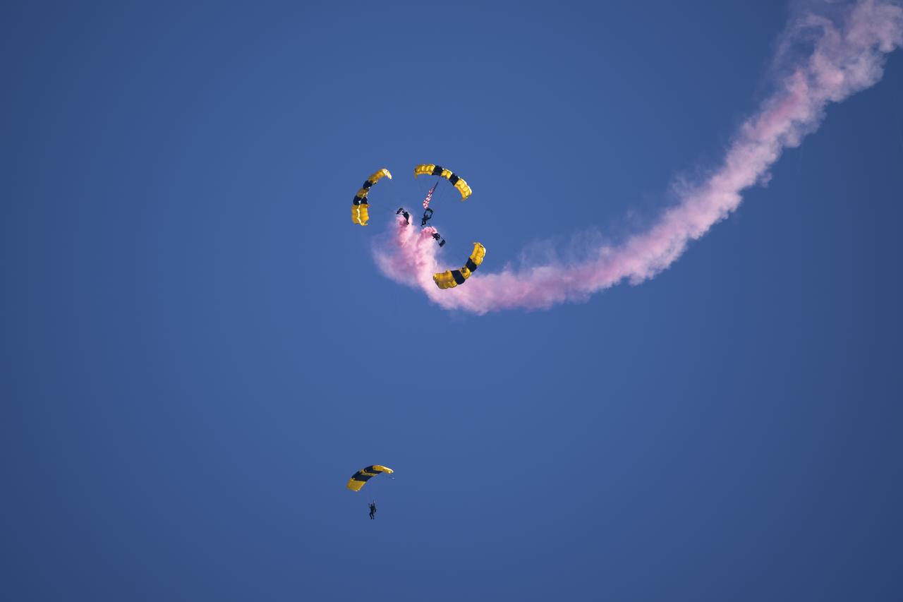
The United States Army Parachute Team, the Golden Knights, are seen during the opening ceremony of the Joint Base Andrews Air Show, Friday, Sept. 12, 2025, at Joint Base Andrews in Prince George's County, Maryland. NASA astronaut Nick Hague was on hand to provide remarks and meet with guests. Hague spent 171 days onboard the International Space Station as part of Expedition 72. Photo Credit: (NASA/Bill Ingalls)

Robert Schmidle Pitts Aerobatics perform, Friday, Sept. 12, 2025, during the Joint Base Andrews Air Show at Joint Base Andrews in Prince George's County, Maryland. NASA astronaut Nick Hague was on hand to provide remarks and meet with guests. Hague spent 171 days onboard the International Space Station as part of Expedition 72. Photo Credit: (NASA/Bill Ingalls)

The United States Army Parachute Team, the Golden Knights, are seen during the opening ceremony of the Joint Base Andrews Air Show, Friday, Sept. 12, 2025, at Joint Base Andrews in Prince George's County, Maryland. NASA astronaut Nick Hague was on hand to provide remarks and meet with guests. Hague spent 171 days onboard the International Space Station as part of Expedition 72. Photo Credit: (NASA/Bill Ingalls)
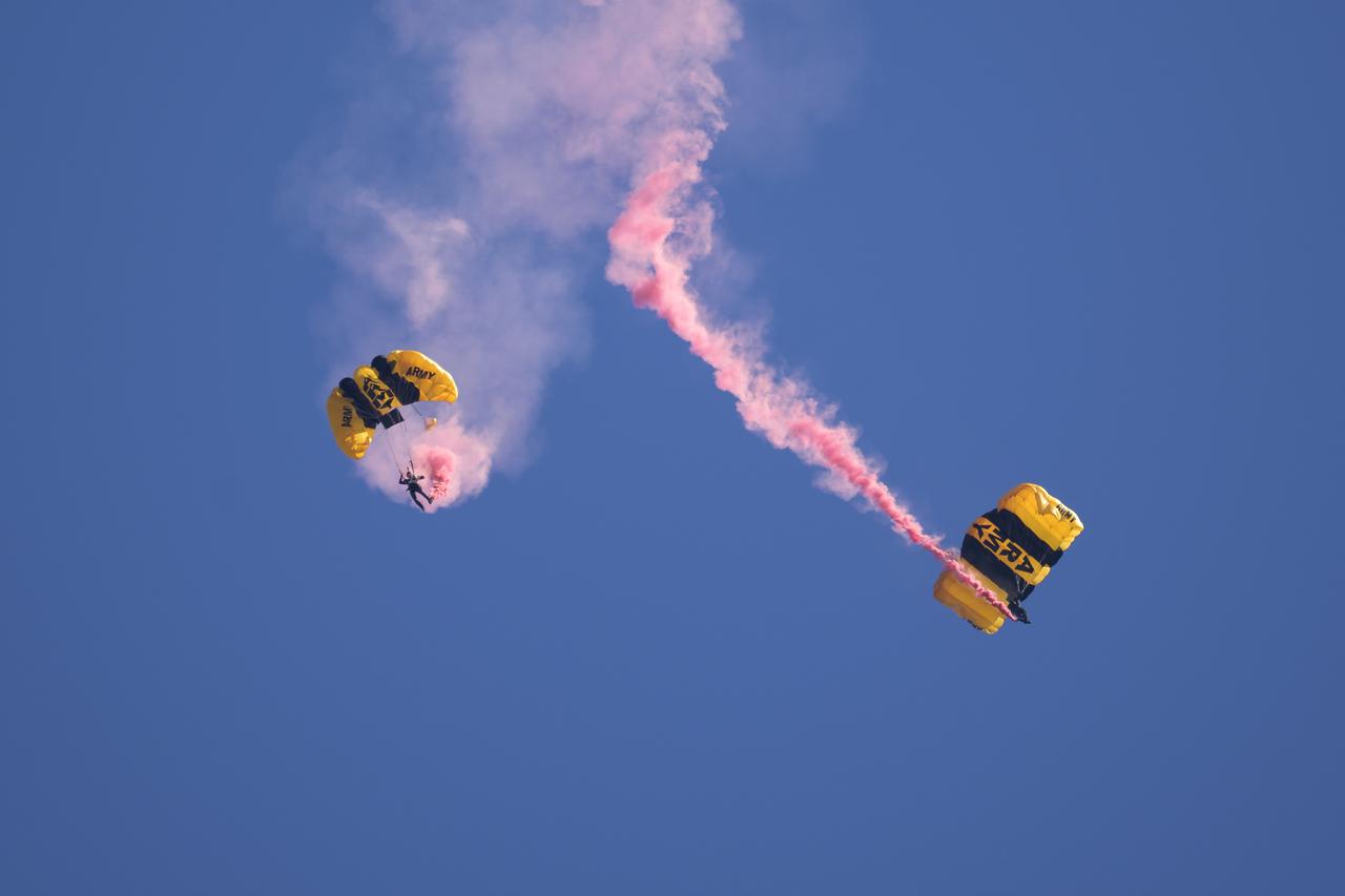
The United States Army Parachute Team, the Golden Knights, are seen during the opening ceremony of the Joint Base Andrews Air Show, Friday, Sept. 12, 2025, at Joint Base Andrews in Prince George's County, Maryland. NASA astronaut Nick Hague was on hand to provide remarks and meet with guests. Hague spent 171 days onboard the International Space Station as part of Expedition 72. Photo Credit: (NASA/Bill Ingalls)
The United States Army Parachute Team, the Golden Knights, are seen during the opening ceremony of the Joint Base Andrews Air Show, Friday, Sept. 12, 2025, at Joint Base Andrews in Prince George's County, Maryland. NASA astronaut Nick Hague was on hand to provide remarks and meet with guests. Hague spent 171 days onboard the International Space Station as part of Expedition 72. Photo Credit: (NASA/Bill Ingalls)

A U.S. Navy F/A-15F Super Hornet jet performs, Friday, Sept. 12, 2025, during the Joint Base Andrews Air Show at Joint Base Andrews in Prince George's County, Maryland. NASA astronaut Nick Hague was on hand to provide remarks and meet with guests. Hague spent 171 days onboard the International Space Station as part of Expedition 72. Photo Credit: (NASA/Bill Ingalls)

Warbird Thunder SNJ planes perform, Friday, Sept. 12, 2025, during the Joint Base Andrews Air Show at Joint Base Andrews in Prince George's County, Maryland. NASA astronaut Nick Hague was on hand to provide remarks and meet with guests. Hague spent 171 days onboard the International Space Station as part of Expedition 72. Photo Credit: (NASA/Bill Ingalls)
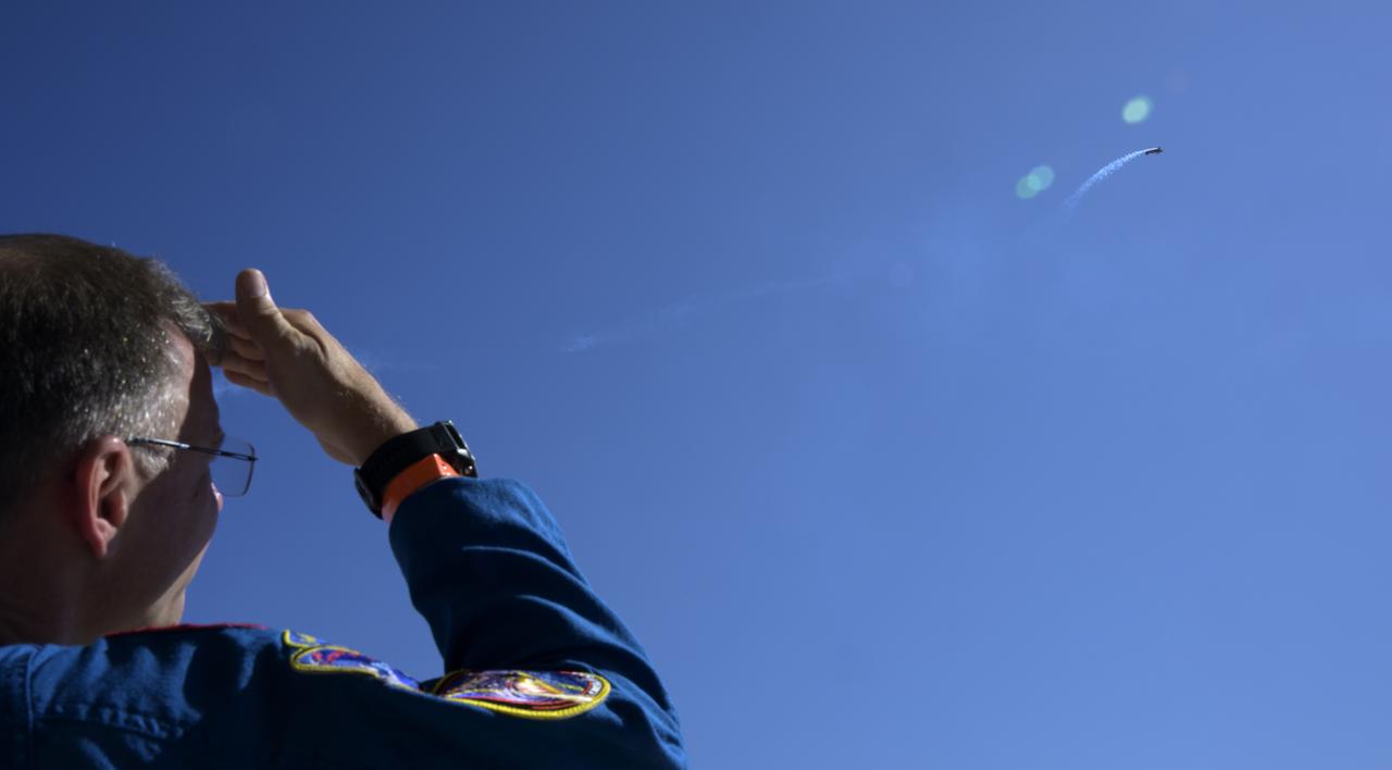
NASA astronaut Nick Hague watches a U.S. Navy F/A-15F Super Hornet jet fly, Friday, Sept. 12, 2025, during the Joint Base Andrews Air Show at Joint Base Andrews in Prince George's County, Maryland. Hague spent 171 days onboard the International Space Station as part of Expedition 72. Photo Credit: (NASA/Bill Ingalls)

Warbird Thunder SNJ planes perform, Friday, Sept. 12, 2025, during the Joint Base Andrews Air Show at Joint Base Andrews in Prince George's County, Maryland. NASA astronaut Nick Hague was on hand to provide remarks and meet with guests. Hague spent 171 days onboard the International Space Station as part of Expedition 72. Photo Credit: (NASA/Bill Ingalls)
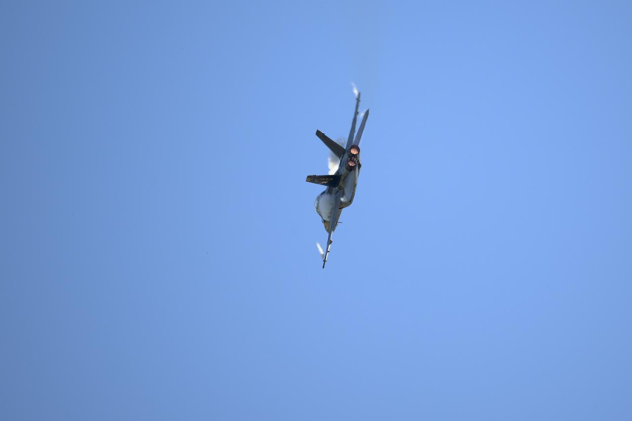
A U.S. Navy F/A-15F Super Hornet jet performs, Friday, Sept. 12, 2025, during the Joint Base Andrews Air Show at Joint Base Andrews in Prince George's County, Maryland. NASA astronaut Nick Hague was on hand to provide remarks and meet with guests. Hague spent 171 days onboard the International Space Station as part of Expedition 72. Photo Credit: (NASA/Bill Ingalls)

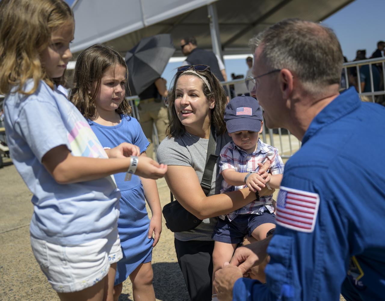
5-year old Vivian Simms, and her father Ryan Simms, meet with NASA astronaut Nick Hague, Friday, Sept. 12, 2025, during the Joint Base Andrews Air Show at Joint Base Andrews in Prince George's County, Maryland. Hague spent 171 days onboard the International Space Station as part of Expedition 72. Photo Credit: (NASA/Bill Ingalls)
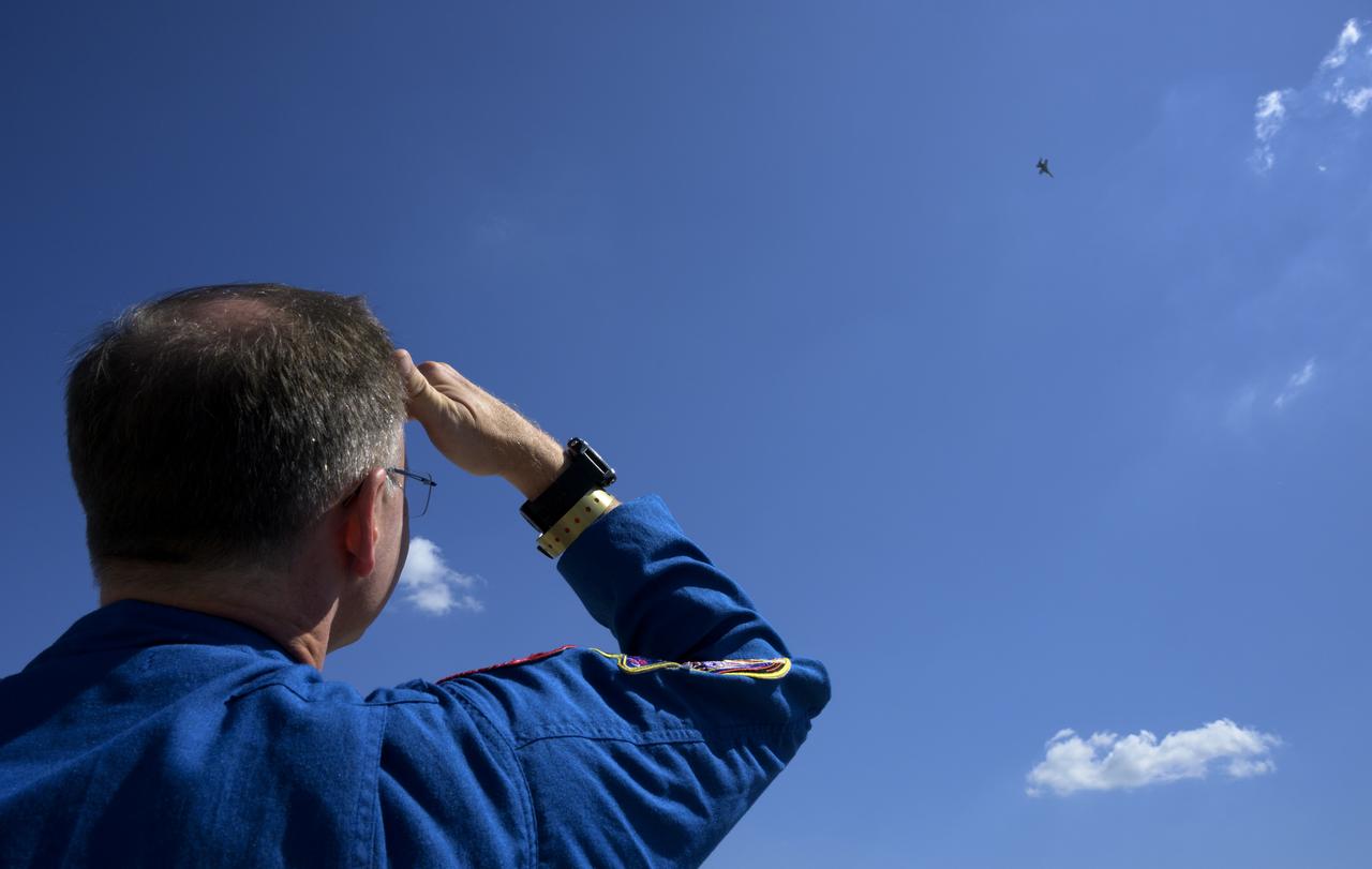
NASA astronaut Nick Hague watches a U.S. Navy F/A-15F Super Hornet jet fly, Friday, Sept. 12, 2025, during the Joint Base Andrews Air Show at Joint Base Andrews in Prince George's County, Maryland. Hague spent 171 days onboard the International Space Station as part of Expedition 72. Photo Credit: (NASA/Bill Ingalls)

The B-25J “Panchito” plane performs, Friday, Sept. 12, 2025, during the Joint Base Andrews Air Show at Joint Base Andrews in Prince George's County, Maryland. NASA astronaut Nick Hague was on hand to provide remarks and meet with guests. Hague spent 171 days onboard the International Space Station as part of Expedition 72. Photo Credit: (NASA/Bill Ingalls)

A U.S. Navy F/A-15F Super Hornet jet performs, Friday, Sept. 12, 2025, during the Joint Base Andrews Air Show at Joint Base Andrews in Prince George's County, Maryland. NASA astronaut Nick Hague was on hand to provide remarks and meet with guests. Hague spent 171 days onboard the International Space Station as part of Expedition 72. Photo Credit: (NASA/Bill Ingalls)

Pilots taxi past spectators in their U.S. Navy F/A-15F Super Hornet jet, Friday, Sept. 12, 2025, during the Joint Base Andrews Air Show at Joint Base Andrews in Prince George's County, Maryland. NASA astronaut Nick Hague was on hand to provide remarks and meet with guests. Hague spent 171 days onboard the International Space Station as part of Expedition 72. Photo Credit: (NASA/Bill Ingalls)

A U.S. Navy F/A-15F Super Hornet jet performs, Friday, Sept. 12, 2025, during the Joint Base Andrews Air Show at Joint Base Andrews in Prince George's County, Maryland. NASA astronaut Nick Hague was on hand to provide remarks and meet with guests. Hague spent 171 days onboard the International Space Station as part of Expedition 72. Photo Credit: (NASA/Bill Ingalls)
This visualization shows early test renderings of a global computational model of Earth's atmosphere based on data from NASA's Goddard Earth Observing System Model, Version 5 (GEOS-5). This particular run, called Nature Run 2, was run on a supercomputer, spanned 2 years of simulation time at 30 minute intervals, and produced Petabytes of output. The visualization spans a little more than 7 days of simulation time which is 354 time steps. The time period was chosen because a simulated category-4 typhoon developed off the coast of China. The 7 day period is repeated several times during the course of the visualization. Credit: NASA's Scientific Visualization Studio Read more or download here: <a href="http://svs.gsfc.nasa.gov/goto?4180" rel="nofollow">svs.gsfc.nasa.gov/goto?4180</a> <b><a href="http://www.nasa.gov/audience/formedia/features/MP_Photo_Guidelines.html" rel="nofollow">NASA image use policy.</a></b> <b><a href="http://www.nasa.gov/centers/goddard/home/index.html" rel="nofollow">NASA Goddard Space Flight Center</a></b> enables NASA’s mission through four scientific endeavors: Earth Science, Heliophysics, Solar System Exploration, and Astrophysics. Goddard plays a leading role in NASA’s accomplishments by contributing compelling scientific knowledge to advance the Agency’s mission. <b>Follow us on <a href="http://twitter.com/NASAGoddardPix" rel="nofollow">Twitter</a></b> <b>Like us on <a href="http://www.facebook.com/pages/Greenbelt-MD/NASA-Goddard/395013845897?ref=tsd" rel="nofollow">Facebook</a></b> <b>Find us on <a href="http://instagram.com/nasagoddard?vm=grid" rel="nofollow">Instagram</a></b>
This MOC image shows a landslide that occurred off of a steep slope in Tithonium Chasma, part of the vast Valles Marineris trough system
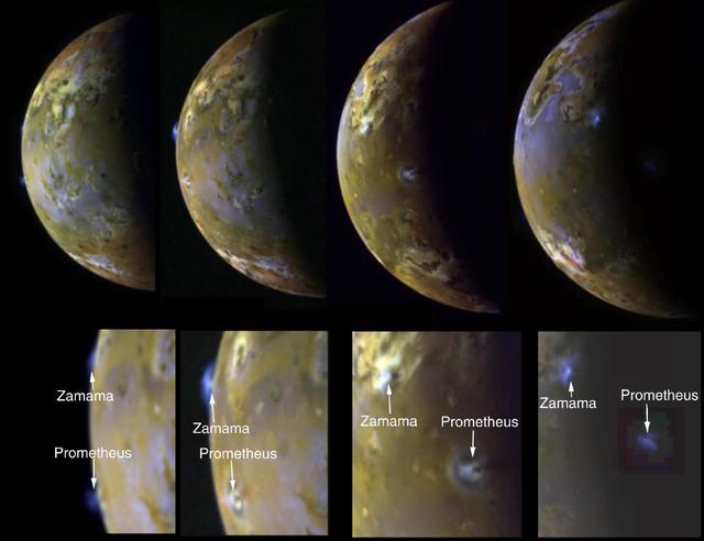
Sequence Showing Active Volcanic Plumes on Io

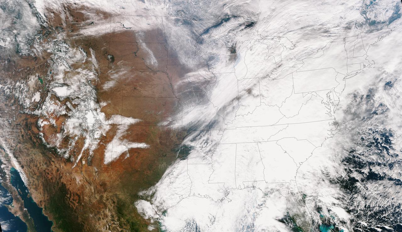
NOAA's GOES-East satellite provided a look at the frigid eastern two-thirds of the U.S. on Jan. 7, 2015, that shows a blanket of northern snow, lake-effect snow from the Great Lakes and clouds behind the Arctic cold front. A visible picture captured at 1600 UTC (11 a.m. EST) showed the effects of the latest Arctic outbreak. The cold front that brought the Arctic air has moved as far south as Florida, and stretches back over the Gulf of Mexico and just west of Texas today. The image shows clouds behind the frontal boundary stretching from the Carolinas west over the Heartland. Farther north, a wide band of fallen snow covers the ground from New England west to Montana, with rivers appearing like veins. The GOES-East satellite image also shows wind-whipped lake-effect snows off the Great Lakes, blowing to the southeast. Meanwhile, Florida, the nation's warm spot appeared almost cloud-free. To create the image, NASA/NOAA's GOES Project used cloud data from NOAA's GOES-East satellite and overlaid it on a true-color image of land and ocean created by data from the Moderate Resolution Imaging Spectroradiometer, or MODIS, instrument that flies aboard NASA's Aqua and Terra satellites. Together, those data created the entire picture of the Arctic outbreak. The forecast from NOAA's National Weather Service Weather Prediction Center (WPC) calls for more snow along the Appalachian Mountains from Tennessee north to upstate New York. Snow is also expected to fall from New England west to Montana, and in eastern New Mexico and the Colorado Rockies. The WPC summary for Jan. 7 noted: Bitter cold will be felt from the western High Plains to the Mid-Atlantic and Northeast U.S. for the next few days. Widespread subzero overnight lows are forecast for the Dakotas, Upper Midwest, Great Lakes, and interior New England. Wind Chill Advisories and Warnings are in effect for many of these areas. GOES-East provides visible and infrared images over the eastern U.S. and the Atlantic Ocean from its fixed orbit in space. NOAA's GOES satellites provide the kind of continuous monitoring necessary for intensive data analysis. Geostationary describes an orbit in which a satellite is always in the same position with respect to the rotating Earth. This allows GOES to hover continuously over one position on Earth's surface, appearing stationary. As a result, GOES provide a constant vigil for the atmospheric triggers for severe weather conditions such as tornadoes, flash floods, hail storms and hurricanes. For updated information about the storm system, visit NOAA's NWS website: <a href="http://www.weather.gov" rel="nofollow">www.weather.gov</a> For more information about GOES satellites, visit: <a href="http://www.goes.noaa.gov/" rel="nofollow">www.goes.noaa.gov/</a> or goes.gsfc.nasa.gov/ Rob Gutro NASA's Goddard Space Flight Center, Greenbelt, Md. <b><a href="http://www.nasa.gov/audience/formedia/features/MP_Photo_Guidelines.html" rel="nofollow">NASA image use policy.</a></b> <b><a href="http://www.nasa.gov/centers/goddard/home/index.html" rel="nofollow">NASA Goddard Space Flight Center</a></b> enables NASA’s mission through four scientific endeavors: Earth Science, Heliophysics, Solar System Exploration, and Astrophysics. Goddard plays a leading role in NASA’s accomplishments by contributing compelling scientific knowledge to advance the Agency’s mission. <b>Follow us on <a href="http://twitter.com/NASAGoddardPix" rel="nofollow">Twitter</a></b> <b>Like us on <a href="http://www.facebook.com/pages/Greenbelt-MD/NASA-Goddard/395013845897?ref=tsd" rel="nofollow">Facebook</a></b> <b>Find us on <a href="http://instagram.com/nasagoddard?vm=grid" rel="nofollow">Instagram</a></b>
This true color image of the Continental United States was taken on Nov. 25, 2013 by the Suomi NPP satellite and shows the system as it moves through the South and Midwest. The National Weather Service noted that a complex and powerful storm system continues to generate widespread moderate to heavy rainfall and snows in various parts of the eastern United States as travelers make their way to destinations to celebrate Thanksgiving and Hanukkah on Nov. 28. There are two low-pressure areas working together. One was centered near New Jersey while the other was located over the Carolinas. From the Southeast to New England widespread moderate to heavy rainfall is expected. The rains will also affect the Mid-Atlantic and Southeastern United States, although those regions are not expected to get as much of a soaking. The Appalachians and interior New England are expected to receive snowfall. Areas of heavy snow are forecast for northwestern Indiana and northwestern Pennsylvania on Nov. 27. Snows will blanket the north central United States from the Dakotas to Minnesota, Iowa, Wisconsin, Michigan, the Ohio and Tennessee Valleys, upstate New York and parts of northern New England. The National Weather Service noted that cold air is moving in behind the storm and drop temperatures along the eastern U.S. making for a chilly Thanksgiving. Credit: NASA/NOAA <b><a href="http://www.nasa.gov/audience/formedia/features/MP_Photo_Guidelines.html" rel="nofollow">NASA image use policy.</a></b> <b><a href="http://www.nasa.gov/centers/goddard/home/index.html" rel="nofollow">NASA Goddard Space Flight Center</a></b> enables NASA’s mission through four scientific endeavors: Earth Science, Heliophysics, Solar System Exploration, and Astrophysics. Goddard plays a leading role in NASA’s accomplishments by contributing compelling scientific knowledge to advance the Agency’s mission. <b>Follow us on <a href="http://twitter.com/NASA_GoddardPix" rel="nofollow">Twitter</a></b> <b>Like us on <a href="http://www.facebook.com/pages/Greenbelt-MD/NASA-Goddard/395013845897?ref=tsd" rel="nofollow">Facebook</a></b> <b>Find us on <a href="http://instagram.com/nasagoddard?vm=grid" rel="nofollow">Instagram</a></b>
On Nov. 22, 2014 from 5:29 to 6:04 p.m. EST., the moon partially obscured the view of the sun from NASA's Solar Dynamics Observatory. This phenomenon, which is called a lunar transit, could only be seen from SDO's point of view. In 2014, SDO captured four such transits -- including its longest ever recorded, which occurred on Jan. 30, and lasted two and a half hours. SDO imagery during a lunar transit always shows a crisp horizon on the moon -- a reflection of the fact that the moon has no atmosphere around it to distort the light from the sun. The horizon is so clear in these images that mountains and valleys in the terrain can be seen. Credit: NASA/SDO <b><a href="http://www.nasa.gov/audience/formedia/features/MP_Photo_Guidelines.html" rel="nofollow">NASA image use policy.</a></b> <b><a href="http://www.nasa.gov/centers/goddard/home/index.html" rel="nofollow">NASA Goddard Space Flight Center</a></b> enables NASA’s mission through four scientific endeavors: Earth Science, Heliophysics, Solar System Exploration, and Astrophysics. Goddard plays a leading role in NASA’s accomplishments by contributing compelling scientific knowledge to advance the Agency’s mission. <b>Follow us on <a href="http://twitter.com/NASAGoddardPix" rel="nofollow">Twitter</a></b> <b>Like us on <a href="http://www.facebook.com/pages/Greenbelt-MD/NASA-Goddard/395013845897?ref=tsd" rel="nofollow">Facebook</a></b> <b>Find us on <a href="http://instagrid.me/nasagoddard/?vm=grid" rel="nofollow">Instagram</a></b>

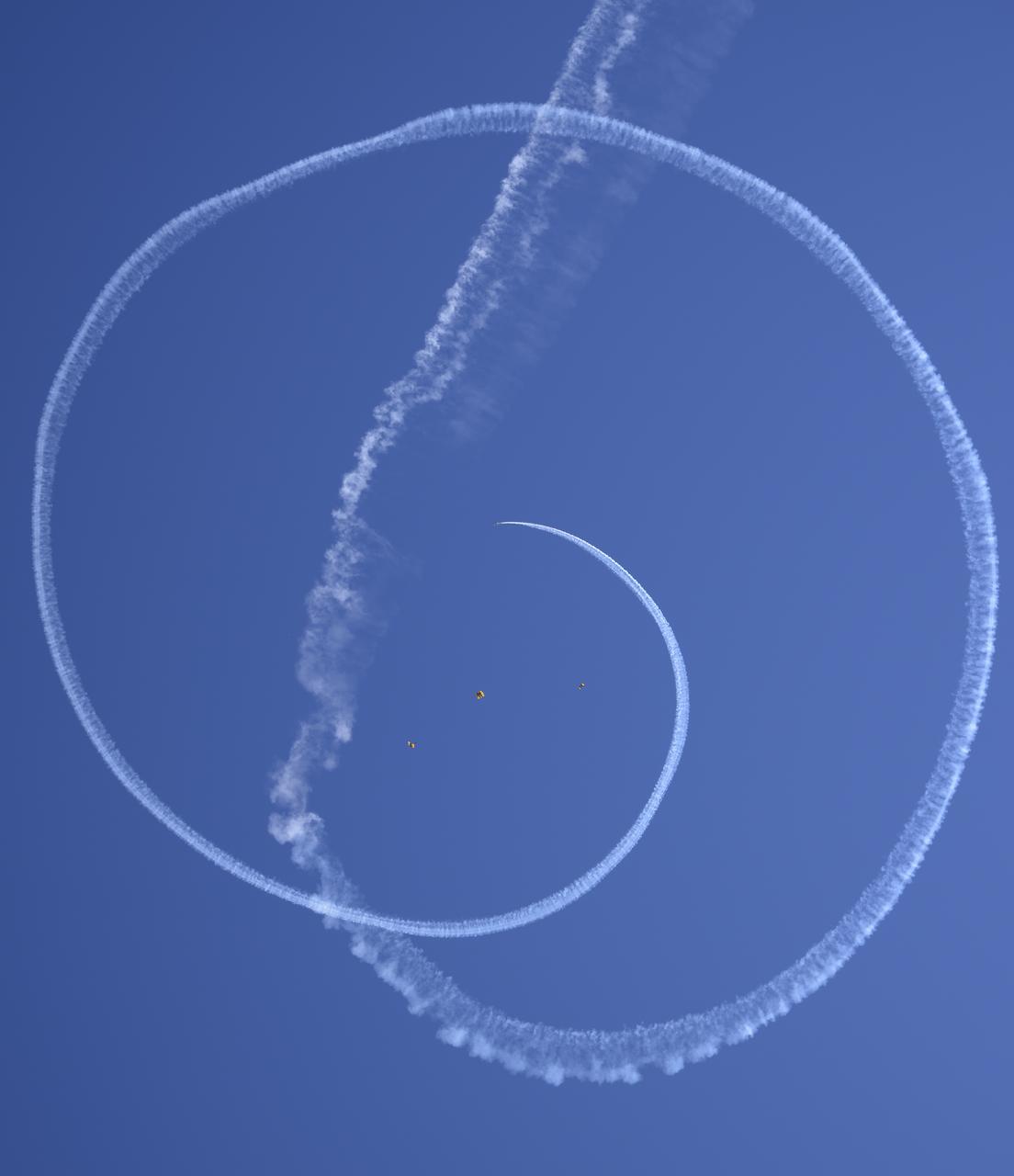
NASA astronaut Nick Hague watches as the United States Army Parachute Team, the Golden Knights, perform during the opening ceremony of the Joint Base Andrews Air Show, Friday, Sept. 12, 2025, at Joint Base Andrews in Prince George's County, Maryland. Hague spent 171 days onboard the International Space Station as part of Expedition 72. Photo Credit: (NASA/Bill Ingalls)

NASA astronaut Nick Hague watches as Robert Schmidle Pitts Aerobatics perform, Friday, Sept. 12, 2025, during the Joint Base Andrews Air Show at Joint Base Andrews in Prince George's County, Maryland. Hague spent 171 days onboard the International Space Station as part of Expedition 72. Photo Credit: (NASA/Bill Ingalls)

NASA astronaut Nick Hague watches as the United States Army Parachute Team, the Golden Knights, perform during the opening ceremony of the Joint Base Andrews Air Show, Friday, Sept. 12, 2025, at Joint Base Andrews in Prince George's County, Maryland. Hague spent 171 days onboard the International Space Station as part of Expedition 72. Photo Credit: (NASA/Bill Ingalls)

Warbird Thunder SNJ planes perform in the background as NASA astronaut Nick Hague meets with attendees, Friday, Sept. 12, 2025, during the Joint Base Andrews Air Show at Joint Base Andrews in Prince George's County, Maryland. Hague spent 171 days onboard the International Space Station as part of Expedition 72. Photo Credit: (NASA/Bill Ingalls)
NASA astronaut Nick Hague watches as Robert Schmidle Pitts Aerobatics perform, Friday, Sept. 12, 2025, during the Joint Base Andrews Air Show at Joint Base Andrews in Prince George's County, Maryland. Hague spent 171 days onboard the International Space Station as part of Expedition 72. Photo Credit: (NASA/Bill Ingalls)
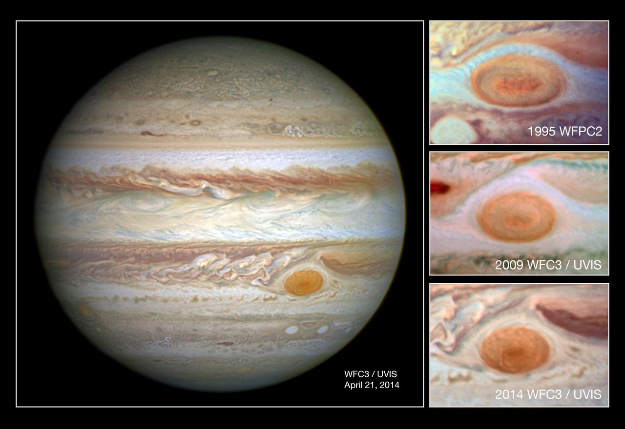
In this comparison image the photo at the top was taken by Hubble's Wide Field Planetary Camera 2 in 1995 and shows the spot at a diameter of just under 21 000km; the second down shows a 2009 WFC3 photo of the spot at a diameter of just under 18 000km; and the lowest shows the newest image from WFC3 taken in 2014 with the spot at its smallest yet, with diameter of just 16 000km. -- Jupiter's trademark Great Red Spot -- a swirling anti-cyclonic storm larger than Earth -- has shrunk to its smallest size ever measured. According to Amy Simon of NASA's Goddard Space Flight Center in Greenbelt, Maryland, recent NASA Hubble Space Telescope observations confirm the Great Red Spot now is approximately 10,250 miles across. Astronomers have followed this downsizing since the 1930s. Historic observations as far back as the late 1800s gauged the storm to be as large as 25,500 miles on its long axis. NASA Voyager 1 and Voyager 2 flybys of Jupiter in 1979 measured it to be 14,500 miles across. In 1995, a Hubble photo showed the long axis of the spot at an estimated 13,020 miles across. And in a 2009 photo, it was measured at 11,130 miles across. Beginning in 2012, amateur observations revealed a noticeable increase in the rate at which the spot is shrinking -- by 580 miles per year -- changing its shape from an oval to a circle. Read more: <a href="http://1.usa.gov/1mvuo0R" rel="nofollow">1.usa.gov/1mvuo0R</a> Credit: NASA/ESA <b><a href="http://www.nasa.gov/audience/formedia/features/MP_Photo_Guidelines.html" rel="nofollow">NASA image use policy.</a></b> <b><a href="http://www.nasa.gov/centers/goddard/home/index.html" rel="nofollow">NASA Goddard Space Flight Center</a></b> enables NASA’s mission through four scientific endeavors: Earth Science, Heliophysics, Solar System Exploration, and Astrophysics. Goddard plays a leading role in NASA’s accomplishments by contributing compelling scientific knowledge to advance the Agency’s mission. <b>Follow us on <a href="http://twitter.com/NASAGoddardPix" rel="nofollow">Twitter</a></b> <b>Like us on <a href="http://www.facebook.com/pages/Greenbelt-MD/NASA-Goddard/395013845897?ref=tsd" rel="nofollow">Facebook</a></b> <b>Find us on <a href="http://instagram.com/nasagoddard?vm=grid" rel="nofollow">Instagram</a></b>

NASA image release June 6, 2010 Like a July 4 fireworks display a young, glittering collection of stars looks like an aerial burst. The cluster is surrounded by clouds of interstellar gas and dust - the raw material for new star formation. The nebula, located 20,000 light-years away in the constellation Carina, contains a central cluster of huge, hot stars, called NGC 3603. This environment is not as peaceful as it looks. Ultraviolet radiation and violent stellar winds have blown out an enormous cavity in the gas and dust enveloping the cluster, providing an unobstructed view of the cluster. Most of the stars in the cluster were born around the same time but differ in size, mass, temperature, and color. The course of a star's life is determined by its mass, so a cluster of a given age will contain stars in various stages of their lives, giving an opportunity for detailed analyses of stellar life cycles. NGC 3603 also contains some of the most massive stars known. These huge stars live fast and die young, burning through their hydrogen fuel quickly and ultimately ending their lives in supernova explosions. Star clusters like NGC 3603 provide important clues to understanding the origin of massive star formation in the early, distant universe. Astronomers also use massive clusters to study distant starbursts that occur when galaxies collide, igniting a flurry of star formation. The proximity of NGC 3603 makes it an excellent lab for studying such distant and momentous events. This Hubble Space Telescope image was captured in August 2009 and December 2009 with the Wide Field Camera 3 in both visible and infrared light, which trace the glow of sulfur, hydrogen, and iron. The Hubble Space Telescope is a project of international cooperation between NASA and the European Space Agency. NASA’s Goddard Space Flight Center manages the telescope. The Space Telescope Science Institute (STScI) conducts Hubble science operations. STScI is operated for NASA by the Association of Universities for Research in Astronomy, Inc. in Washington, D.C. Credit: NASA, ESA, R. O'Connell (University of Virginia), F. Paresce (National Institute for Astrophysics, Bologna, Italy), E. Young (Universities Space Research Association/Ames Research Center), the WFC3 Science Oversight Committee, and the Hubble Heritage Team (STScI/AURA) <b><a href="http://www.nasa.gov/centers/goddard/home/index.html" rel="nofollow">NASA Goddard Space Flight Center</a></b> is home to the nation's largest organization of combined scientists, engineers and technologists that build spacecraft, instruments and new technology to study the Earth, the sun, our solar system, and the universe.
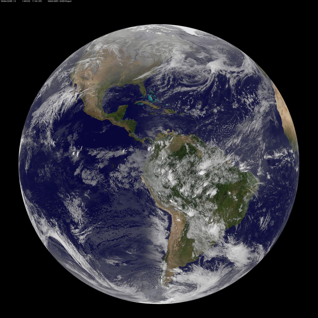
This full-disk image from NOAA’s GOES-13 satellite was captured at 11:45 UTC (7:45 a.m. EDT) and shows the Americas on March 20, 2014. This date marks the start of astronomical spring in the northern hemisphere. <b><a href="http://goes.gsfc.nasa.gov/" rel="nofollow">Credit: NOAA/NASA GOES Project</a></b> <b><a href="http://www.nasa.gov/audience/formedia/features/MP_Photo_Guidelines.html" rel="nofollow">NASA image use policy.</a></b> <b><a href="http://www.nasa.gov/centers/goddard/home/index.html" rel="nofollow">NASA Goddard Space Flight Center</a></b> enables NASA’s mission through four scientific endeavors: Earth Science, Heliophysics, Solar System Exploration, and Astrophysics. Goddard plays a leading role in NASA’s accomplishments by contributing compelling scientific knowledge to advance the Agency’s mission. <b>Follow us on <a href="http://twitter.com/NASAGoddardPix" rel="nofollow">Twitter</a></b> <b>Like us on <a href="http://www.facebook.com/pages/Greenbelt-MD/NASA-Goddard/395013845897?ref=tsd" rel="nofollow">Facebook</a></b> <b>Find us on <a href="http://instagram.com/nasagoddard?vm=grid" rel="nofollow">Instagram</a></b>

Members of JPL's assembly, test and launch operations team for NASA's Perseverance mission show appreciation for their newly named rover. The image was taken on March 4, 2020, at a payload processing facility at NASA's Kennedy Space Center. The plate is actually a rock and debris shield, designed to protect a cable that carries power and data from computers in the rover's body to actuators in the arm, as well as to the rotary percussive drill and instruments in the turret. Weighing in at about 104 grams (3.7 ounces), the 17-inch-long by 3.25-inch-wide (43-centimeter-long by 8.26-centimeter-wide) plate was cut using a water jet. The surface was coated with black thermal paint before a computer-guided laser generated the name "Perseverance" by ablating paint off the surface. The nameplate was attached to the rover on March 4, 2020. https://photojournal.jpl.nasa.gov/catalog/PIA23767
This animation shows images of the far side of the moon, illuminated by the sun, as it crosses between the DISCOVR spacecraft's Earth Polychromatic Imaging Camera (EPIC) camera and telescope, and the Earth - one million miles away. Credits: NASA/NOAA A NASA camera aboard the Deep Space Climate Observatory (DSCOVR) satellite captured a unique view of the moon as it moved in front of the sunlit side of Earth last month. The series of test images shows the fully illuminated “dark side” of the moon that is never visible from Earth. The images were captured by NASA’s Earth Polychromatic Imaging Camera (EPIC), a four megapixel CCD camera and telescope on the DSCOVR satellite orbiting 1 million miles from Earth. From its position between the sun and Earth, DSCOVR conducts its primary mission of real-time solar wind monitoring for the National Oceanic and Atmospheric Administration (NOAA). Read more: <a href="http://www.nasa.gov/feature/goddard/from-a-million-miles-away-nasa-camera-shows-moon-crossing-face-of-earth" rel="nofollow">www.nasa.gov/feature/goddard/from-a-million-miles-away-na...</a> <b><a href="http://www.nasa.gov/audience/formedia/features/MP_Photo_Guidelines.html" rel="nofollow">NASA image use policy.</a></b> <b><a href="http://www.nasa.gov/centers/goddard/home/index.html" rel="nofollow">NASA Goddard Space Flight Center</a></b> enables NASA’s mission through four scientific endeavors: Earth Science, Heliophysics, Solar System Exploration, and Astrophysics. Goddard plays a leading role in NASA’s accomplishments by contributing compelling scientific knowledge to advance the Agency’s mission. <b>Follow us on <a href="http://twitter.com/NASAGoddardPix" rel="nofollow">Twitter</a></b> <b>Like us on <a href="http://www.facebook.com/pages/Greenbelt-MD/NASA-Goddard/395013845897?ref=tsd" rel="nofollow">Facebook</a></b> <b>Find us on <a href="http://instagrid.me/nasagoddard/?vm=grid" rel="nofollow">Instagram</a></b>
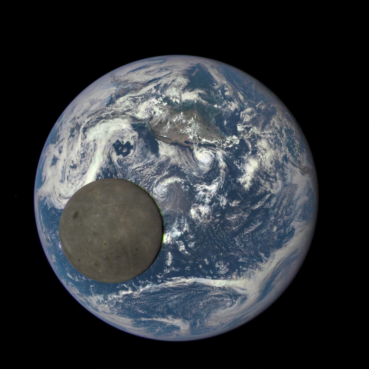
This animation still image shows the far side of the moon, illuminated by the sun, as it crosses between the DISCOVR spacecraft's Earth Polychromatic Imaging Camera (EPIC) camera and telescope, and the Earth - one million miles away. Credits: NASA/NOAA A NASA camera aboard the Deep Space Climate Observatory (DSCOVR) satellite captured a unique view of the moon as it moved in front of the sunlit side of Earth last month. The series of test images shows the fully illuminated “dark side” of the moon that is never visible from Earth. The images were captured by NASA’s Earth Polychromatic Imaging Camera (EPIC), a four megapixel CCD camera and telescope on the DSCOVR satellite orbiting 1 million miles from Earth. From its position between the sun and Earth, DSCOVR conducts its primary mission of real-time solar wind monitoring for the National Oceanic and Atmospheric Administration (NOAA). Read more: <a href="http://www.nasa.gov/feature/goddard/from-a-million-miles-away-nasa-camera-shows-moon-crossing-face-of-earth" rel="nofollow">www.nasa.gov/feature/goddard/from-a-million-miles-away-na...</a> <b><a href="http://www.nasa.gov/audience/formedia/features/MP_Photo_Guidelines.html" rel="nofollow">NASA image use policy.</a></b> <b><a href="http://www.nasa.gov/centers/goddard/home/index.html" rel="nofollow">NASA Goddard Space Flight Center</a></b> enables NASA’s mission through four scientific endeavors: Earth Science, Heliophysics, Solar System Exploration, and Astrophysics. Goddard plays a leading role in NASA’s accomplishments by contributing compelling scientific knowledge to advance the Agency’s mission. <b>Follow us on <a href="http://twitter.com/NASAGoddardPix" rel="nofollow">Twitter</a></b> <b>Like us on <a href="http://www.facebook.com/pages/Greenbelt-MD/NASA-Goddard/395013845897?ref=tsd" rel="nofollow">Facebook</a></b> <b>Find us on <a href="http://instagrid.me/nasagoddard/?vm=grid" rel="nofollow">Instagram</a></b>
The green of St. Patrick's Day in the Mid-Atlantic was covered by white snow as a result of a late winter snow storm. The covering of the green was captured in a movie made at NASA using NOAA's GOES satellite data. The winter storm dropped snow totals from 6" to 12" of snow from Baltimore, Md. to Richmond, Va. The storm arrived during the evening of March 16 and continued through March 17. As of 1 p.m. EDT, light bands of snow continued to fall throughout the Washington, D.C. area. NOAA's GOES-East satellite captured the path the storm took through the Mid-Atlantic as it moved in from the west on March 15 and dropped snow March 16 and 17. NOAA's GOES-East satellite sits in a fixed orbit in space and captures visible and infrared imagery of all weather over the eastern U.S. and Atlantic Ocean. As of 1 p.m. EDT on March 17, the National Weather Service still maintained a Winter Storm Warning from Cecil County in northeastern Maryland that stretched west to Frederick County. The warning continued in Virginia counties including Clarke, Warren, Rappahannock, Madison and stretched to Albemarle and southwest. Southeastern counties in Virginia south of the city of Fredericksburg remained under a Winter Weather Advisory. GOES satellites provide the kind of continuous monitoring necessary for intensive data analysis. Geostationary describes an orbit in which a satellite is always in the same position with respect to the rotating Earth. This allows GOES to hover continuously over one position on Earth's surface, appearing stationary. As a result, GOES provide a constant vigil for the atmospheric "triggers" for severe weather conditions such as tornadoes, flash floods, hail storms and hurricanes. For updated information about the storm system, visit NOAA's NWS website: <a href="http://www.weather.gov" rel="nofollow">www.weather.gov</a> For more information about GOES satellites, visit: <a href="http://www.goes.noaa.gov/" rel="nofollow">www.goes.noaa.gov/</a> or goes.gsfc.nasa.gov/ Rob Gutro NASA's Goddard Space Flight Center <b><a href="http://www.nasa.gov/audience/formedia/features/MP_Photo_Guidelines.html" rel="nofollow">NASA image use policy.</a></b> <b><a href="http://www.nasa.gov/centers/goddard/home/index.html" rel="nofollow">NASA Goddard Space Flight Center</a></b> enables NASA’s mission through four scientific endeavors: Earth Science, Heliophysics, Solar System Exploration, and Astrophysics. Goddard plays a leading role in NASA’s accomplishments by contributing compelling scientific knowledge to advance the Agency’s mission. <b>Follow us on <a href="http://twitter.com/NASAGoddardPix" rel="nofollow">Twitter</a></b> <b>Like us on <a href="http://www.facebook.com/pages/Greenbelt-MD/NASA-Goddard/395013845897?ref=tsd" rel="nofollow">Facebook</a></b> <b>Find us on <a href="http://instagram.com/nasagoddard?vm=grid" rel="nofollow">Instagram</a></b>
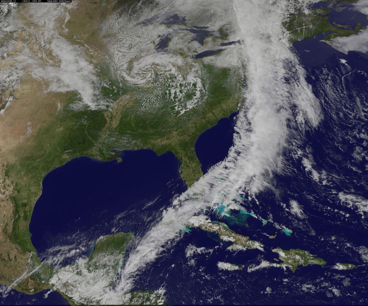
NOAA's GOES-East satellite captured an image of a powerful cold front that triggered flash flood watches and warnings along the U.S. East Coast on May 16. NOAA's National Weather Service noted flash flooding was possible from New England into eastern North Carolina today, May 16. The clouds associated with the long cold front was captured using visible data from NOAA's GOES-East or GOES-13 satellite on at 1900 UTC (3:00 p.m. EDT) and was made into an image by NASA/NOAA's GOES Project at NASA's Goddard Space Flight Center in Greenbelt, Md. The clouds stretched from Maine south through the Mid-Atlantic down to southern Florida with a tail of clouds extending into the western Caribbean Sea. South of Lake Michigan the rounded swirl of clouds indicates another low pressure system. GOES satellites provide the kind of continuous monitoring necessary for intensive data analysis. Geostationary describes an orbit in which a satellite is always in the same position with respect to the rotating Earth. This allows GOES to hover continuously over one position on Earth's surface, appearing stationary. As a result, GOES provide a constant vigil for the atmospheric "triggers" for severe weather conditions such as tornadoes, flash floods, hail storms and hurricanes. For updated information about the storm system, visit NOAA's National Weather Service website: <a href="http://www.weather.gov" rel="nofollow">www.weather.gov</a> For more information about GOES satellites, visit: <a href="http://www.goes.noaa.gov/" rel="nofollow">www.goes.noaa.gov/</a> or <a href="http://goes.gsfc.nasa.gov/" rel="nofollow">goes.gsfc.nasa.gov/</a> Rob Gutro NASA's Goddard Space Flight Center <b><a href="http://www.nasa.gov/audience/formedia/features/MP_Photo_Guidelines.html" rel="nofollow">NASA image use policy.</a></b> <b><a href="http://www.nasa.gov/centers/goddard/home/index.html" rel="nofollow">NASA Goddard Space Flight Center</a></b> enables NASA’s mission through four scientific endeavors: Earth Science, Heliophysics, Solar System Exploration, and Astrophysics. Goddard plays a leading role in NASA’s accomplishments by contributing compelling scientific knowledge to advance the Agency’s mission. <b>Follow us on <a href="http://twitter.com/NASAGoddardPix" rel="nofollow">Twitter</a></b> <b>Like us on <a href="http://www.facebook.com/pages/Greenbelt-MD/NASA-Goddard/395013845897?ref=tsd" rel="nofollow">Facebook</a></b> <b>Find us on <a href="http://instagram.com/nasagoddard?vm=grid" rel="nofollow">Instagram</a></b>

NOAA's GOES-15 satellite captured the southern California "June Gloom" on June 10, 2013. That's a weather pattern that creates cloudy, overcast skies and cool temperatures. The "June Gloom" of low lying stratus clouds form over the ocean and can be pushed to coastal areas by wind. It usually happens off the west coast of California during the late spring and early summer. As for the "seam" of blue within the "June Gloom," it appears to be actinoform clouds, a seam in the marine stratocumulus aka "June Gloom" of southern California. Actinoform clouds and marine stratus in general are only marginally stable. Sometimes the cloud deck spontaneously dissolves along a line by drizzling out the moisture. This seam is an unusually long curve that is not identified with a coastline or a weather front. Dennis Chesters/Rob Gutro NASA's Goddard Space Flight Center, Greenbelt, Md. REFERENCES <a href="http://en.wikipedia.org/wiki/Actinoform_cloud" rel="nofollow">en.wikipedia.org/wiki/Actinoform_cloud</a> <a href="http://en.wikipedia.org/wiki/June_Gloom" rel="nofollow">en.wikipedia.org/wiki/June_Gloom</a> <b><a href="http://www.nasa.gov/audience/formedia/features/MP_Photo_Guidelines.html" rel="nofollow">NASA image use policy.</a></b> <b><a href="http://www.nasa.gov/centers/goddard/home/index.html" rel="nofollow">NASA Goddard Space Flight Center</a></b> enables NASA’s mission through four scientific endeavors: Earth Science, Heliophysics, Solar System Exploration, and Astrophysics. Goddard plays a leading role in NASA’s accomplishments by contributing compelling scientific knowledge to advance the Agency’s mission. <b>Follow us on <a href="http://twitter.com/NASA_GoddardPix" rel="nofollow">Twitter</a></b> <b>Like us on <a href="http://www.facebook.com/pages/Greenbelt-MD/NASA-Goddard/395013845897?ref=tsd" rel="nofollow">Facebook</a></b> <b>Find us on <a href="http://instagram.com/nasagoddard?vm=grid" rel="nofollow">Instagram</a></b>

NASA image release Thursday, May 31, 2012 <b>To view a video from this Hubble release go to: <a href="http://www.flickr.com/photos/gsfc/7309212940">www.flickr.com/photos/gsfc/7309212940</a> </b> Caption: This illustration shows a stage in the predicted merger between our Milky Way galaxy and the neighboring Andromeda galaxy, as it will unfold over the next several billion years. In this image, representing Earth's night sky in 3.75 billion years, Andromeda (left) fills the field of view and begins to distort the Milky Way with tidal pull. Credit: NASA; ESA; Z. Levay and R. van der Marel, STScI; T. Hallas; and A. Mellinger To read more go to: <a href="http://www.nasa.gov/mission_pages/hubble/science/milky-way-collide.html" rel="nofollow">www.nasa.gov/mission_pages/hubble/science/milky-way-colli...</a> <b><a href="http://www.nasa.gov/audience/formedia/features/MP_Photo_Guidelines.html" rel="nofollow">NASA image use policy.</a></b> <b><a href="http://www.nasa.gov/centers/goddard/home/index.html" rel="nofollow">NASA Goddard Space Flight Center</a></b> enables NASA’s mission through four scientific endeavors: Earth Science, Heliophysics, Solar System Exploration, and Astrophysics. Goddard plays a leading role in NASA’s accomplishments by contributing compelling scientific knowledge to advance the Agency’s mission. <b>Follow us on <a href="http://twitter.com/NASA_GoddardPix" rel="nofollow">Twitter</a></b> <b>Like us on <a href="http://www.facebook.com/pages/Greenbelt-MD/NASA-Goddard/395013845897?ref=tsd" rel="nofollow">Facebook</a></b> <b>Find us on <a href="http://instagrid.me/nasagoddard/?vm=grid" rel="nofollow">Instagram</a></b>
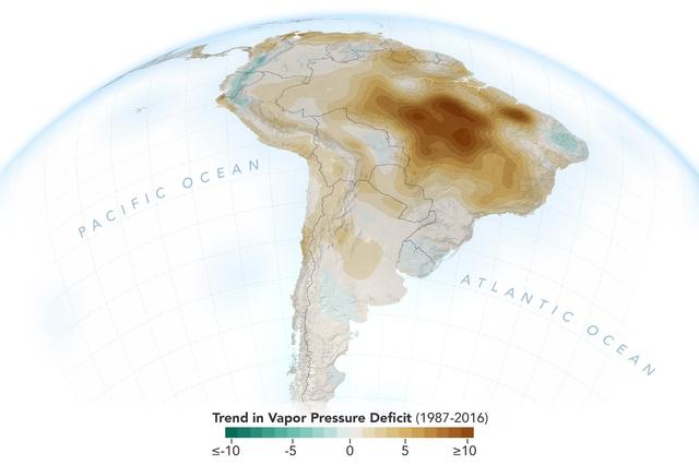
The image shows the trend of vapor pressure deficit over the Amazon rainforest during the dry season months — August through October — from 1987 to 2016. The measurements are shown in millibars — a standard unit of measure for atmospheric pressure. Vapor pressure deficit is the ratio of how much moisture is present in the atmosphere compared to how much moisture the atmosphere can hold. The trend shows the decline of moisture in the air, particularly across the south and southeastern Amazon, which is caused by a combination of human activities, including changes in land use, forest burning and its byproduct, black carbon, along with activities that have increased carbon monoxide and carbon dioxide levels in the region. https://photojournal.jpl.nasa.gov/catalog/PIA23425

<b>View detail image here: <a href="http://bit.ly/1bvJlaN" rel="nofollow">bit.ly/1bvJlaN</a></b> Arctic air has surged into the U.S. pushing into the Southeastern states and dropping high temperatures there into the 20s with colder wind chills. This NOAA GOES-East satellite image was captured at 1445 UTC/9:45 a.m. EST on January 28, and between the clouds and the snow on the ground with cold air overhead, it appears as if much of the U.S. has been covered by an "Arctic Blanket." According to NOAA's National Weather Service (NWS), the Gulf coast states from southern Louisiana east to the Carolinas are facing a wintry mix of precipitation along the southern edge of the Arctic air. Meanwhile, NWS notes that wind chills throughout much of the central and eastern U.S. are in single and negative numbers during the day on January 28. The GOES-East satellite is managed and operated by NOAA. This image was created by the NASA/NOAA GOES Project at NASA's Goddard Space Flight Center in Greenbelt, Md. Rob Gutro NASA's Goddard Space Flight Center <b><a href="http://goes.gsfc.nasa.gov/" rel="nofollow">Credit: NOAA/NASA GOES Project</a></b> <b><a href="http://www.nasa.gov/audience/formedia/features/MP_Photo_Guidelines.html" rel="nofollow">NASA image use policy.</a></b> <b><a href="http://www.nasa.gov/centers/goddard/home/index.html" rel="nofollow">NASA Goddard Space Flight Center</a></b> enables NASA’s mission through four scientific endeavors: Earth Science, Heliophysics, Solar System Exploration, and Astrophysics. Goddard plays a leading role in NASA’s accomplishments by contributing compelling scientific knowledge to advance the Agency’s mission. <b>Follow us on <a href="http://twitter.com/NASAGoddardPix" rel="nofollow">Twitter</a></b> <b>Like us on <a href="http://www.facebook.com/pages/Greenbelt-MD/NASA-Goddard/395013845897?ref=tsd" rel="nofollow">Facebook</a></b> <b>Find us on <a href="http://instagram.com/nasagoddard?vm=grid" rel="nofollow">Instagram</a></b>
Scientists use satellite data to peer into the massive storm – learning how and why it changed throughout its course. More info: <a href="http://www.nasa.gov/matthew" rel="nofollow">www.nasa.gov/matthew</a> <b><a href="http://www.nasa.gov/audience/formedia/features/MP_Photo_Guidelines.html" rel="nofollow">NASA image use policy.</a></b> <b><a href="http://www.nasa.gov/centers/goddard/home/index.html" rel="nofollow">NASA Goddard Space Flight Center</a></b> enables NASA’s mission through four scientific endeavors: Earth Science, Heliophysics, Solar System Exploration, and Astrophysics. Goddard plays a leading role in NASA’s accomplishments by contributing compelling scientific knowledge to advance the Agency’s mission. <b>Follow us on <a href="http://twitter.com/NASAGoddardPix" rel="nofollow">Twitter</a></b> <b>Like us on <a href="http://www.facebook.com/pages/Greenbelt-MD/NASA-Goddard/395013845897?ref=tsd" rel="nofollow">Facebook</a></b> <b>Find us on <a href="http://instagrid.me/nasagoddard/?vm=grid" rel="nofollow">Instagram</a></b>
Arctic air has surged into the U.S. pushing into the Southeastern states and dropping high temperatures there into the 20s with colder wind chills. This NOAA GOES-East satellite image was captured at 1445 UTC/9:45 a.m. EST on January 28, and between the clouds and the snow on the ground with cold air overhead, it appears as if much of the U.S. has been covered by an "Arctic Blanket." According to NOAA's National Weather Service (NWS), the Gulf coast states from southern Louisiana east to the Carolinas are facing a wintry mix of precipitation along the southern edge of the Arctic air. Meanwhile, NWS notes that wind chills throughout much of the central and eastern U.S. are in single and negative numbers during the day on January 28. The GOES-East satellite is managed and operated by NOAA. This image was created by the NASA/NOAA GOES Project at NASA's Goddard Space Flight Center in Greenbelt, Md. Rob Gutro NASA's Goddard Space Flight Center <b><a href="http://goes.gsfc.nasa.gov/" rel="nofollow">Credit: NOAA/NASA GOES Project</a></b> <b><a href="http://www.nasa.gov/audience/formedia/features/MP_Photo_Guidelines.html" rel="nofollow">NASA image use policy.</a></b> <b><a href="http://www.nasa.gov/centers/goddard/home/index.html" rel="nofollow">NASA Goddard Space Flight Center</a></b> enables NASA’s mission through four scientific endeavors: Earth Science, Heliophysics, Solar System Exploration, and Astrophysics. Goddard plays a leading role in NASA’s accomplishments by contributing compelling scientific knowledge to advance the Agency’s mission. <b>Follow us on <a href="http://twitter.com/NASAGoddardPix" rel="nofollow">Twitter</a></b> <b>Like us on <a href="http://www.facebook.com/pages/Greenbelt-MD/NASA-Goddard/395013845897?ref=tsd" rel="nofollow">Facebook</a></b> <b>Find us on <a href="http://instagram.com/nasagoddard?vm=grid" rel="nofollow">Instagram</a></b>
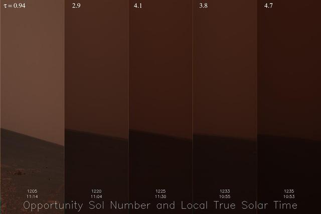
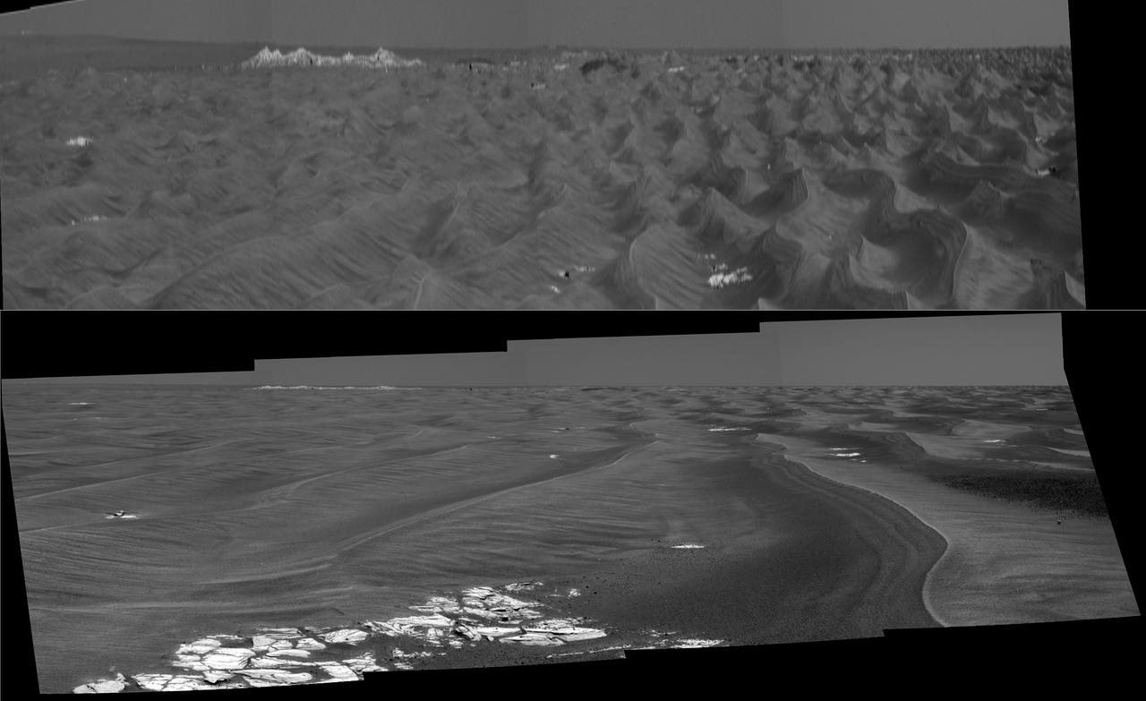
Dust Storm Time Lapse Shows Opportunity Skies Darken

First IMP Image Showing Something That Looks Like Mars
This image from NASA Terra spacecraft shows a perspective view, looking toward the Aso volcanic caldera, which indicates the epicenter with a red star.
This image from NASA Dawn spacecraft shows a surface with craters buried under thick ejected material that displays a grooved texture on the giant asteroid Vesta.
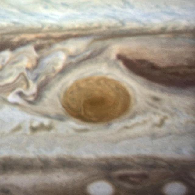
An image of Jupiter's Great Red Spot taken in 2014 with Hubble's WFC3 camera. The spot has a diameter here of 16 000km. -- Jupiter's trademark Great Red Spot -- a swirling anti-cyclonic storm larger than Earth -- has shrunk to its smallest size ever measured. According to Amy Simon of NASA's Goddard Space Flight Center in Greenbelt, Maryland, recent NASA Hubble Space Telescope observations confirm the Great Red Spot now is approximately 10,250 miles across. Astronomers have followed this downsizing since the 1930s. Historic observations as far back as the late 1800s gauged the storm to be as large as 25,500 miles on its long axis. NASA Voyager 1 and Voyager 2 flybys of Jupiter in 1979 measured it to be 14,500 miles across. In 1995, a Hubble photo showed the long axis of the spot at an estimated 13,020 miles across. And in a 2009 photo, it was measured at 11,130 miles across. Beginning in 2012, amateur observations revealed a noticeable increase in the rate at which the spot is shrinking -- by 580 miles per year -- changing its shape from an oval to a circle. Read more: <a href="http://1.usa.gov/1mvuo0R" rel="nofollow">1.usa.gov/1mvuo0R</a> Credit: NASA/ESA <b><a href="http://www.nasa.gov/audience/formedia/features/MP_Photo_Guidelines.html" rel="nofollow">NASA image use policy.</a></b> <b><a href="http://www.nasa.gov/centers/goddard/home/index.html" rel="nofollow">NASA Goddard Space Flight Center</a></b> enables NASA’s mission through four scientific endeavors: Earth Science, Heliophysics, Solar System Exploration, and Astrophysics. Goddard plays a leading role in NASA’s accomplishments by contributing compelling scientific knowledge to advance the Agency’s mission. <b>Follow us on <a href="http://twitter.com/NASAGoddardPix" rel="nofollow">Twitter</a></b> <b>Like us on <a href="http://www.facebook.com/pages/Greenbelt-MD/NASA-Goddard/395013845897?ref=tsd" rel="nofollow">Facebook</a></b> <b>Find us on <a href="http://instagram.com/nasagoddard?vm=grid" rel="nofollow">Instagram</a></b>
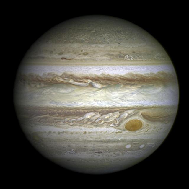
This full-disc image of Jupiter was taken on 21 April 2014 with Hubble's Wide Field Camera 3 (WFC3). -- Jupiter's trademark Great Red Spot -- a swirling anti-cyclonic storm larger than Earth -- has shrunk to its smallest size ever measured. According to Amy Simon of NASA's Goddard Space Flight Center in Greenbelt, Maryland, recent NASA Hubble Space Telescope observations confirm the Great Red Spot now is approximately 10,250 miles across. Astronomers have followed this downsizing since the 1930s. Historic observations as far back as the late 1800s gauged the storm to be as large as 25,500 miles on its long axis. NASA Voyager 1 and Voyager 2 flybys of Jupiter in 1979 measured it to be 14,500 miles across. In 1995, a Hubble photo showed the long axis of the spot at an estimated 13,020 miles across. And in a 2009 photo, it was measured at 11,130 miles across. Beginning in 2012, amateur observations revealed a noticeable increase in the rate at which the spot is shrinking -- by 580 miles per year -- changing its shape from an oval to a circle. Read more: <a href="http://1.usa.gov/1mvuo0R" rel="nofollow">1.usa.gov/1mvuo0R</a> Credit: NASA/ESA <b><a href="http://www.nasa.gov/audience/formedia/features/MP_Photo_Guidelines.html" rel="nofollow">NASA image use policy.</a></b> <b><a href="http://www.nasa.gov/centers/goddard/home/index.html" rel="nofollow">NASA Goddard Space Flight Center</a></b> enables NASA’s mission through four scientific endeavors: Earth Science, Heliophysics, Solar System Exploration, and Astrophysics. Goddard plays a leading role in NASA’s accomplishments by contributing compelling scientific knowledge to advance the Agency’s mission. <b>Follow us on <a href="http://twitter.com/NASAGoddardPix" rel="nofollow">Twitter</a></b> <b>Like us on <a href="http://www.facebook.com/pages/Greenbelt-MD/NASA-Goddard/395013845897?ref=tsd" rel="nofollow">Facebook</a></b> <b>Find us on <a href="http://instagram.com/nasagoddard?vm=grid" rel="nofollow">Instagram</a></b>
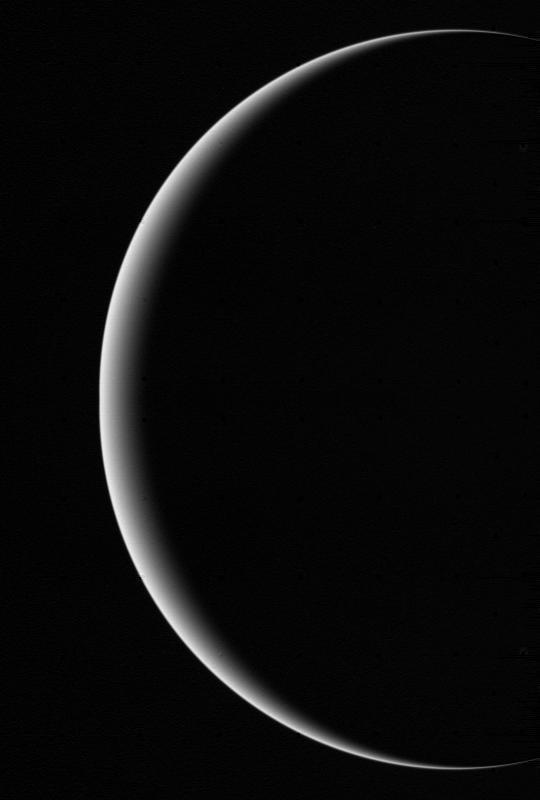
This image shows a crescent Uranus, a view that Earthlings never witnessed until Voyager 2 flew near and then beyond Uranus on Jan 24, 1986. http://photojournal.jpl.nasa.gov/catalog/PIA00346
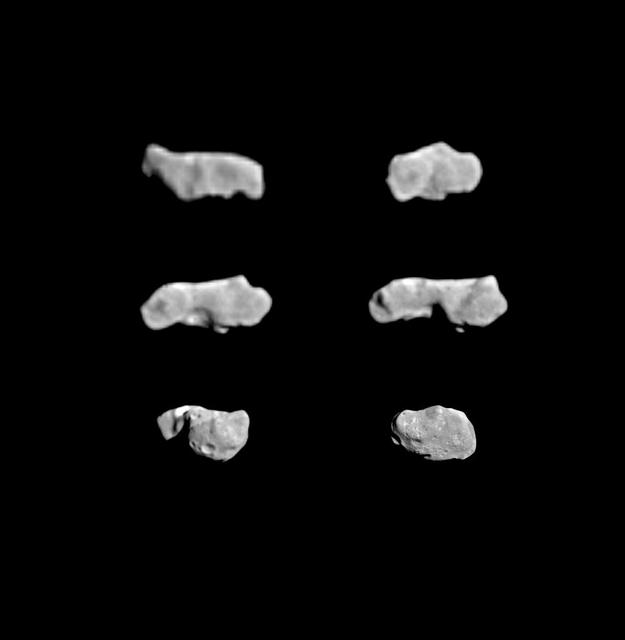
This composite image shows the asteroid 243 Ida as seen from NASA's Galileo spacecraft during its approach on August 28, 1993. http://photojournal.jpl.nasa.gov/catalog/PIA00137
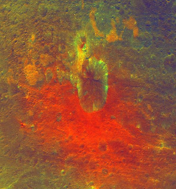
This false-color image obtained by NASA Dawn spacecraft shows a crater on the giant asteroid Vesta. The reddish coloring below the crater points to material that was hurled from Vesta interior during an impact or originated from the impactor itself.
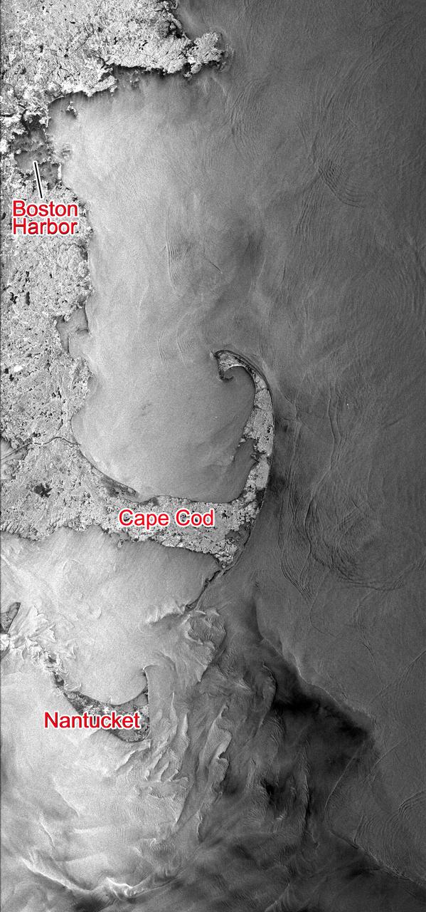
This Seasat synthetic aperture radar image from Aug. 27, 1978, shows the Massachusetts coast from Nantucket Island in the south past Cape Cod and Boston to Cape Ann in the north.

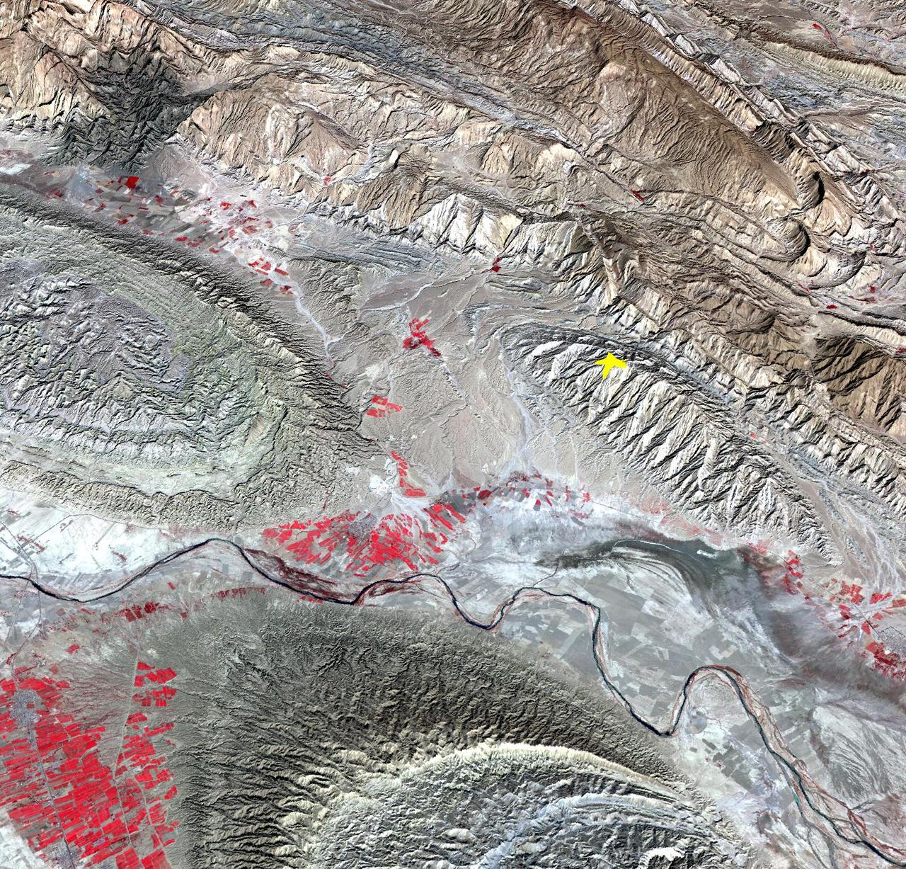
On April 9, 2013 at 11:52 GMT, this image acquired by NASA Terra spacecraft, shows the location of a magnitude 6.3 earthquake hit southwestern Iran Bushehr province near the town of Kaki.
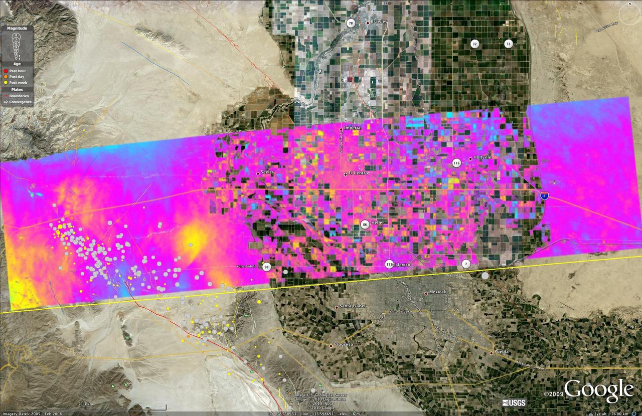
This image shows a UAVSAR interferogram swath overlaid atop a Google Earth image. New NASA airborne radar images show the continuing deformation in Earth surface resulting from the magnitude 7.2 temblor in Baja California on April 4, 2010.
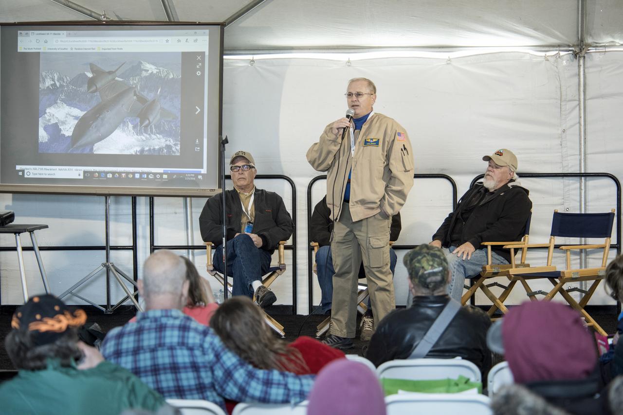
Dana Purifoy, NASA Armstrong director of Flight Operations, talking, and John McKay, former Armstrong SR-71 crew chief, participate on a panel discussion about the triple supersonic aircraft.
This festive NASA Hubble Space Telescope image resembles a holiday wreath made of sparkling lights. The bright southern hemisphere star RS Puppis, at the center of the image, is swaddled in a gossamer cocoon of reflective dust illuminated by the glittering star. The super star is ten times more massive than our sun and 200 times larger. RS Puppis rhythmically brightens and dims over a six-week cycle. It is one of the most luminous in the class of so-called Cepheid variable stars. Its average intrinsic brightness is 15,000 times greater than our sun’s luminosity. The nebula flickers in brightness as pulses of light from the Cepheid propagate outwards. Hubble took a series of photos of light flashes rippling across the nebula in a phenomenon known as a "light echo." Even though light travels through space fast enough to span the gap between Earth and the moon in a little over a second, the nebula is so large that reflected light can actually be photographed traversing the nebula. By observing the fluctuation of light in RS Puppis itself, as well as recording the faint reflections of light pulses moving across the nebula, astronomers are able to measure these light echoes and pin down a very accurate distance. The distance to RS Puppis has been narrowed down to 6,500 light-years (with a margin of error of only one percent). The Hubble Space Telescope is a project of international cooperation between NASA and the European Space Agency. NASA's Goddard Space Flight Center in Greenbelt, Md., manages the telescope. The Space Telescope Science Institute (STScI) in Baltimore, Md., conducts Hubble science operations. STScI is operated by the Association of Universities for Research in Astronomy, Inc., in Washington, D.C. Acknowledgment: H. Bond (STScI and Pennsylvania State University) <b><a href="http://www.nasa.gov/audience/formedia/features/MP_Photo_Guidelines.html" rel="nofollow">NASA image use policy.</a></b> <b><a href="http://www.nasa.gov/centers/goddard/home/index.html" rel="nofollow">NASA Goddard Space Flight Center</a></b> enables NASA’s mission through four scientific endeavors: Earth Science, Heliophysics, Solar System Exploration, and Astrophysics. Goddard plays a leading role in NASA’s accomplishments by contributing compelling scientific knowledge to advance the Agency’s mission. <b>Follow us on <a href="http://twitter.com/NASA_GoddardPix" rel="nofollow">Twitter</a></b> <b>Like us on <a href="http://www.facebook.com/pages/Greenbelt-MD/NASA-Goddard/395013845897?ref=tsd" rel="nofollow">Facebook</a></b> <b>Find us on <a href="http://instagram.com/nasagoddard?vm=grid" rel="nofollow">Instagram</a></b>

Amberly Guerra, left, tries on life support equipment while Ali Zendejas, Betty Mojica and Julian Guerra, her dad, watch.