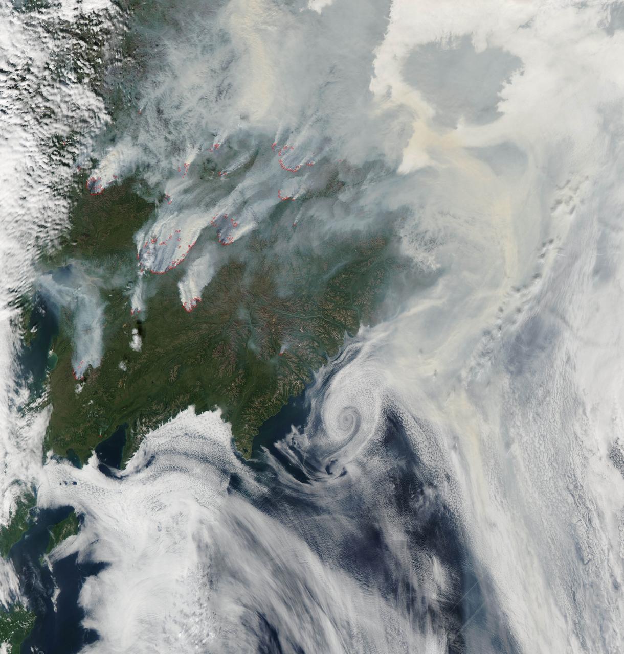
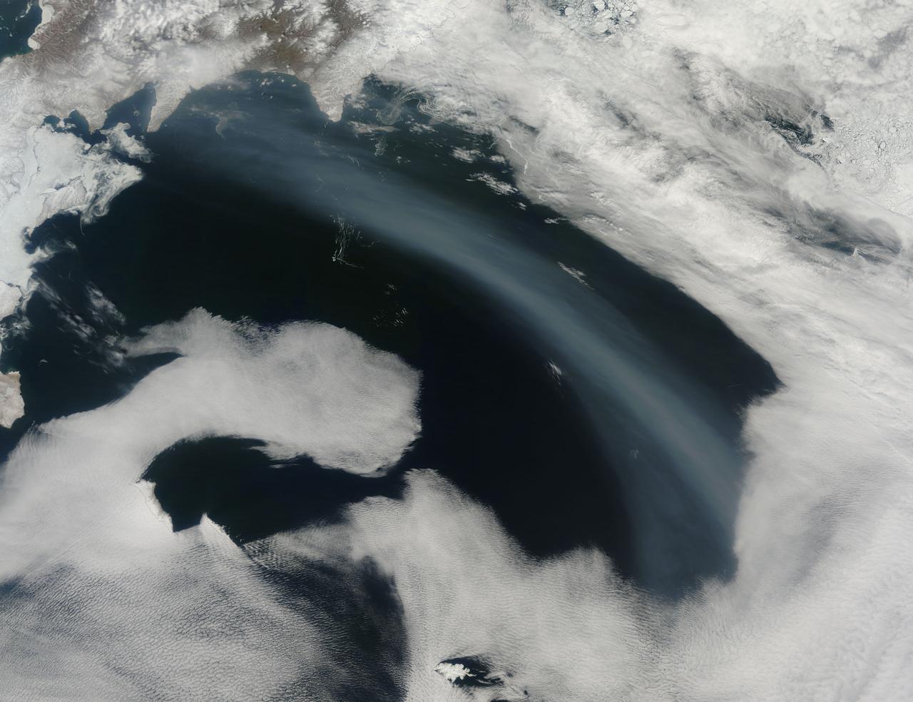
NASA image acquired August 1, 2010 Intense fires continued to burn in the boreal forests of eastern Siberia on August 1, 2010. The fires are outlined in red in this image, acquired by the Moderate Resolution Imaging Spectroradiometer (MODIS) on NASA’s Aqua satellite. The fires span the borders of Russia’s Chukotskiy, Magadan, and Koryakskiy provinces. Burning in coniferous (evergreen) forests, the fires blanketed northeastern Siberia with thick brown smoke. The smoke hugs the ground near the fires, filling valleys, and soars over clouds farther away from the flames. On August 1, the smoke flowed north from the fires and over the Arctic Ocean. A wide view of the Arctic shows the smoke crossing the Bering Strait and clouding skies over northern Alaska. This image is available in additional resolutions from the MODIS Rapid Response Team here: <a href="http://rapidfire.sci.gsfc.nasa.gov/gallery/?2010213-0801/Russia.A2010213.0045.2km.jpg" rel="nofollow">rapidfire.sci.gsfc.nasa.gov/gallery/?2010213-0801/Russia....</a> To view more images from this event go to: <a href="http://earthobservatory.nasa.gov/NaturalHazards/event.php?id=44561" rel="nofollow">earthobservatory.nasa.gov/NaturalHazards/event.php?id=44561</a> NASA image courtesy Jeff Schmaltz, MODIS Rapid Response Team at NASA GSFC. Caption by Holli Riebeek Instrument: Aqua - MODIS <b><a href="http://www.nasa.gov/centers/goddard/home/index.html" rel="nofollow">NASA Goddard Space Flight Center</a></b> is home to the nation's largest organization of combined scientists, engineers and technologists that build spacecraft, instruments and new technology to study the Earth, the sun, our solar system, and the universe. <b>Follow us on <a href="http://twitter.com/NASA_GoddardPix" rel="nofollow">Twitter</a></b> <b>Join us on <a href="http://www.facebook.com/pages/Greenbelt-MD/NASA-Goddard/395013845897?ref=tsd" rel="nofollow">Facebook</a><b></b></b>
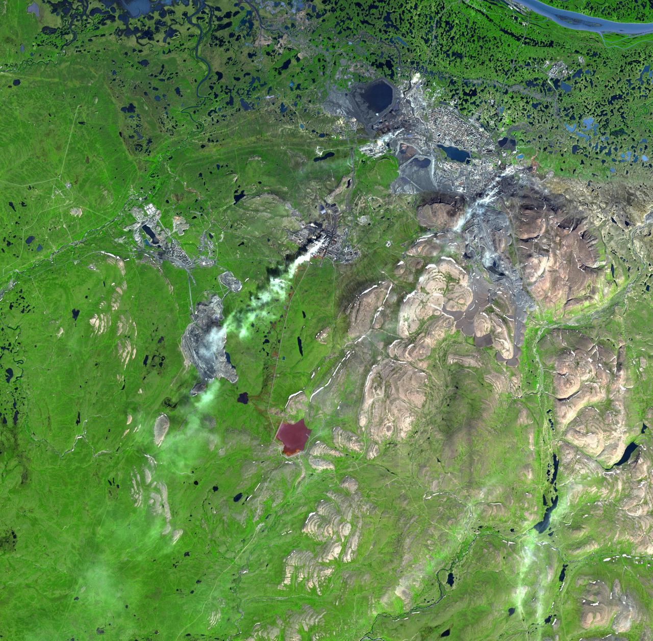
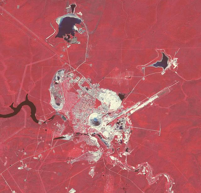
Norilsk is a major city in Krasnoyarsk Krai, Russia, and the northernmost city in Siberia. NASA Terra satellite captured this image on July 21, 2000.
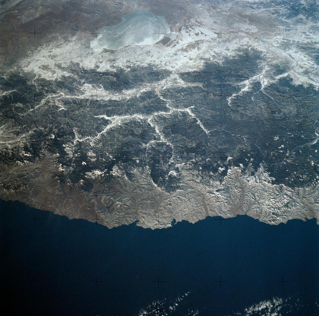
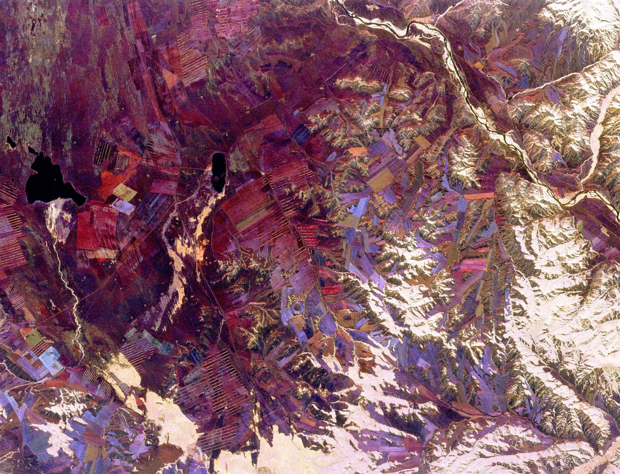
SL4-140-4110 (January 1974) --- View of the USSR, Siberia area from Skylab 4. Other areas seen are Ozero, Kanka, Ussiriysk, the Sea of Japan and Kavalerovo (45.5N, 135.5E). Photo credit: NASA

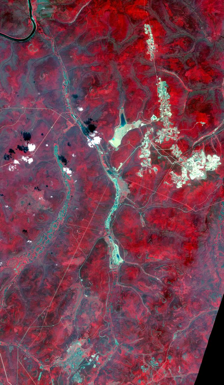
In northestern Siberia, along the Chukchi Sea, and 100 kilometers west of Mys Shmidta, significant evidence of mining is visible in this ASTER image. The numerous small waste piles and small ponds point to dredging operations, most likely for gold. The image was acquired July 15, 2011, covers an area of 27.8 by 36.4 kilometers, and is located at 69.3 degrees north, 178.5 degrees east. https://photojournal.jpl.nasa.gov/catalog/PIA22672
Aldan is the administrative center of the Aldansky District in Siberia, Russia. It was founded in 1923 after discovery of rich gold and uranium deposits. The city can be seen at the bottom of the image. To the north, squiggly tracks in the rivers are the spoilage piles from dredging operations. In the upper right are numerous tailings piles from conventional strip and underground mining operations. The image was acquired July 31, 2019, covers an area of 30.8 by 53 km, and is located near 58.6 degrees north, 125.4 degrees east. https://photojournal.jpl.nasa.gov/catalog/PIA24126
The Mir mine in Siberia is an open pit diamond mine, more than 525 m deep and 1200 m in diameter, making it one of the largest in the world. The diamond-bearing kimberlite pipe was discovered in 1955. With both pit mining and later underground mining, the Mir has produced over 200 million carats of diamonds, the largest weighing 342 carats. The image was acquired July 16, 2019, covers an area of 17 by 17.7 km, and is located at 62.5 degrees north, 114 degrees east. https://photojournal.jpl.nasa.gov/catalog/PIA25856
During the 2003 fire season, blazes in the taiga forests of Eastern Siberia were part of a vast network of fires across Siberia and the Russian Far East, northeast China and northern Mongolia seen here by NASA Terra spacecraft.
Sheveluch Volcano in Kamchatka, Siberia, is one of the frequently active volcanoes located in eastern Siberia. In this image from NASA Terra spacecraft, brownish ash covers the southern part of the mountain, under an ash-laden vertical eruption plume.

GMT336_21_56_Terry Virts_night pass moscow siberia sunrise on array_123

GMT336_21_56_Terry Virts_night pass moscow siberia sunrise on array_123
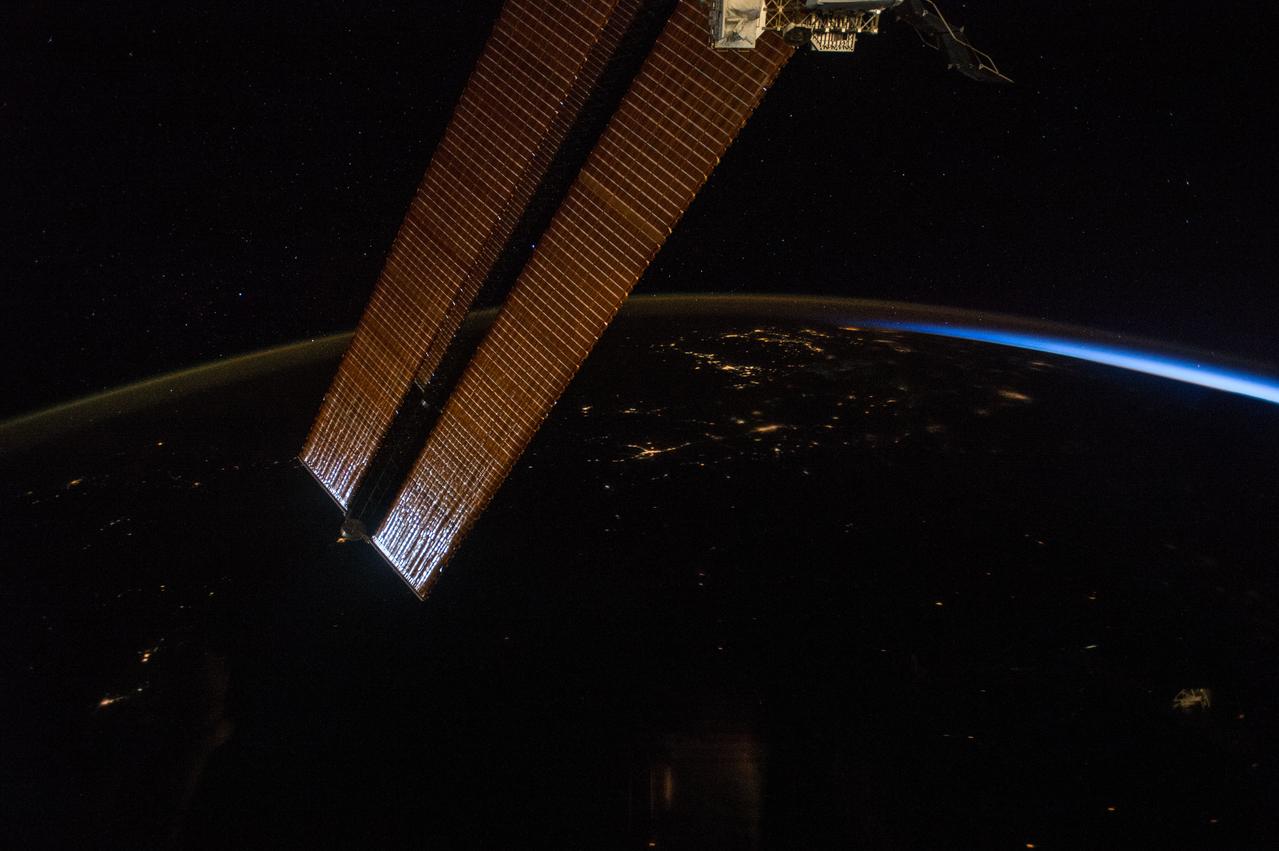
GMT336_21_56_Terry Virts_night pass moscow siberia sunrise on array_123
This spaceborne radar image shows part of the remote central Asian region of Tuva, an autonomous republic of the Russian Federation. Tuva is a mostly mountainous region that lies between western Mongolia and southern Siberia.
The Kondyor Massif is located in Eastern Siberia, Russia, north of the city of Khabarovsk. It is a rare form of igneous intrusion called alkaline-ultrabasic massif and it is full of rare minerals. This image is from NASA Terra satellite.
This image from NASA Terra satellite, acquired on August 18, 2000 during Terra orbit 3562, show the Bering Strait, with Seward Peninsula of Alaska to the east, and Chukotskiy Poluostrov of Siberia to the west.
NASA Terra spacecraft acquired this image of the region north of Lake Baikal on Aug. 22, 2015. For weeks, forest fires have been raging in Siberia around Russia Lake Baikal.
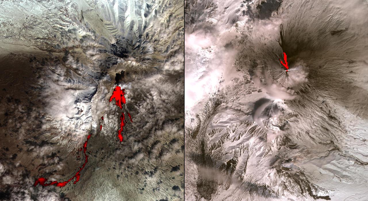
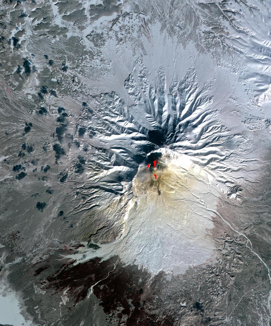
One of the most volcanically active regions of the world is the Kamchatka Peninsula in eastern Siberia, Russia. It is not uncommon for several volcanoes to be erupting at the same time. NASA Terra satellite acquired this image on April 26, 2007

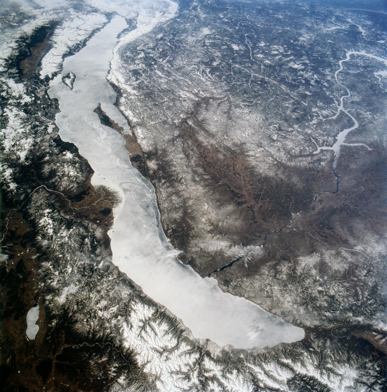
STS060-87-087 (3-11 Feb 1994) --- Lake Baikal, in southeastern Siberia, is the largest freshwater lake in the world by volume, holding nearly 20 per cent of the world's fresh water. Lake Baikal is a biospheric reserve of high international interest to the global scientific community. It is home to some 600 endemic species, many found in no other location. This view shows the northern end of the lake, and was taken in the early morning with low sun highlighting the mountain ranges rimming the lake basin. Pristine forests surround the lake, although heavy logging is evident in other photography of the central and southern portions of the lake. Another unique aspect of Lake Baikal is the existence of the world's only known freshwater hydrothermal springs. The fault system which bounds the lake allows fluids to circulate deep into the Earth and resurface as hot springs around and in the lake. Russian and American scientists are using the Shuttle photography to examine the relationship of the lake's ice cover to areas of known hydrothermal activity. Thus Lake Baikal has been and continues to be a high-priority site for photography from space from both the Space Shuttle and the Russian Space Station MIR.

ISS040-E-027042 (30 June 2014) --- Kulunda Steppe, Siberia in central Russia is featured in this image photographed by an Expedition 40 crew member on the International Space Station. The crew on the station called down to Houston to ask for an explanation of this strange pattern of spikes crossing the Kulunda Steppe in central Russia. The ?spikes? are a prominent visual feature (center) visible from the top of the ISS orbit (approximately 52 degrees north), the highest latitude flown over by the spacecraft. In fact these linear zones are gentle folds in the surface rocks of the area, lying slightly lower than the surrounding lighter-toned agricultural lands. The dark zones are forested with pines and dotted with salt-rich lakes. The image width (left to right edge) represents more than 300 kilometers ground distance, and the forested spikes are nearly that length. The green floodplain of the famous Ob River (right) is the westernmost of Siberia?s three great rivers (the others being the Yenisei and Lena). The Ob flows north (towards the top of the image) for another 2,000 kilometers to the Arctic Ocean. The city of Barnaul (population 612,000), a major center of industry, trade and culture in Siberia, lies on the banks of the river with riverboat, air and rail links to the rest of the country. A broader, winter image of the Kulunda geology and the Ob River can be seen here.
ISS043E190642 (05/13/2015) --- NASA astronaut Terry Virts who is the Commander of Expedition 43 on the International Space Station tweeted this Earth Observation on May 13, 2015, with this comment: "Beautiful part of #Mongolia and #Siberia. Красивейший район Сибири и Монголии".

ISS042E019845 (12/02/2014) ---US Astronaut Terry Virts flight engineer of Expedition 42 on the International Space Station is in the multi windowed Cupola on Dec. 2, 2014 and has the rising sun in view while over Siberia. Virts will spend a total of 6 months in space.
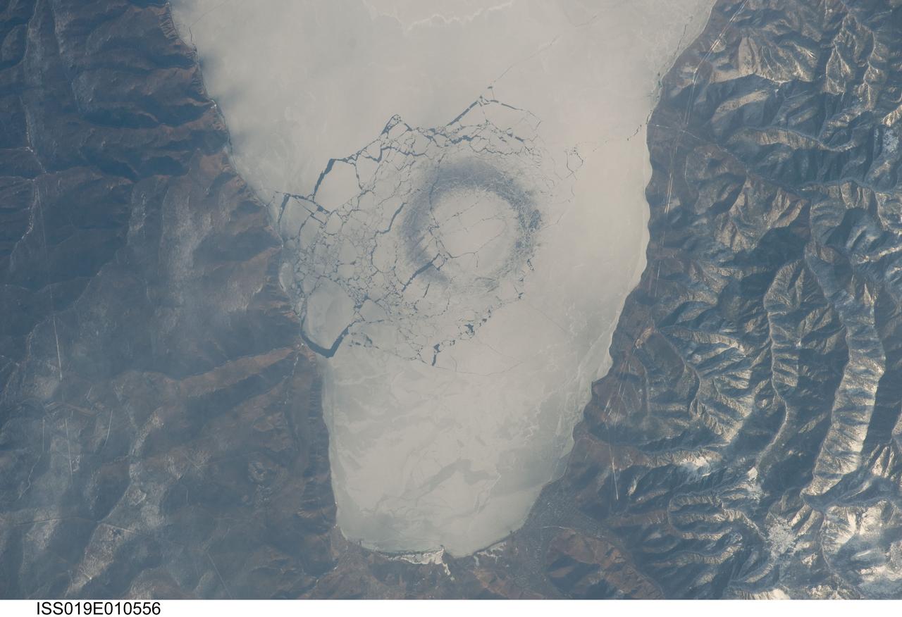
ISS019-E-010556 (23 April 2009) --- A circle in thin ice in Lake Baikal, Russia is featured in this image photographed by an Expedition 19 crewmember on the International Space Station. Late in April 2009, astronauts aboard the station observed a strange circular area of thinned ice (dark in color, with a diameter of about 4.4 kilometers) in the southern end of Lake Baikal in southern Siberia. Lake Baikal is unique in many regards. It is the largest (by volume) and deepest (1,637 meters at the deepest point) fresh water lake on Earth and, as a World Heritage Site, is considered one of Russia?s environmental jewels. The lake?s long, thin and deep profile results from its location in the Baikal Rift valley in Siberia. According to scientists, it is also one of the world?s oldest lakes (25-30 million years old); it contains up to 7 kilometers of sediment deposited on the bottom, and is home to an amazing array of plants and animals, many being found only in Lake Baikal. The lake?s biodiversity includes fresh water seals and several species of fish that are not found elsewhere on Earth. Siberia is remote and cold; ice cover can persist into June. This detailed image shows a circle of thin ice, which is the focal point for ice break up in the very southern end of the lake. While the origin of the circles is unknown, the peculiar pattern suggests convection in the lake?s water column. Ice cover changes rapidly at this time of year. Within a day, the ice can melt almost completely, and then freeze again overnight. Throughout April, the circles are persistent ? they appear when ice cover forms, and then disappear as ice melts. The pattern and appearance suggests that the ice is quite thin.
ISS011-E-09913 (24 May 2005) --- Irkutsk, Siberia, Russian Federation is featured in this image photographed by an Expedition 11 crewmember on the International Space Station. Located approximately 55 kilometers (34 miles) to the northwest of Lake Baikal, Irkutsk is also the chief city of Irkutsk Oblast (equating to a province) in Siberia. The city is located on the Angara River. The central downtown area of the city is depicted in this photograph, as well as the Akademgorodok district around the State University (left of image along the southern bank of the Angara River). The oblique (non-vertical) look angle of this image imparts a three dimension perspective to the scene that accentuates the blockiness of Soviet-era building projects to the east of the downtown area. The Irkutsk Dam (center), built for the generation of hydroelectric power, dramatically widened the river and drowned several stream outlet channels along the north and south banks. The Angara River is the only outlet from Lake Baikal to the southeast, and impoundment of water behind the dam has raised the lake level by 6 meters (20 ft).
STS059-90-098 (9-20 April 1994) --- Ice-covered Lake Baikal, in Siberia, is about 400 miles long within a major rift valley. The water surface is 455 meters above sea level, but the bottom is 1,295 meters below sea level; the lake represents the largest body of fresh water in the world, except for the Antarctic and Greenland ice sheets. A tributary, the Senusi River, has built a delta on the east side. The Angara River exits the lake to the northwest; the city of Irkutsk is under the small, rippled cloud bank that crosses the river. Hasselblad camera.
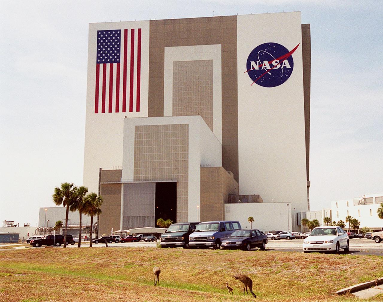
A family of sandhill cranes searches for food on the grounds near the Vehicle Assembly Building. The cranes have been a constant sight in the Launch Complex 39 area during the month of May. Sandhill cranes range from Siberia, Alaska and Arctic islands to Michigan, Minnesota and California; from Florida to Texas. They prefer large freshwater marshes, prairie ponds and marshy tundra. KSC shares a boundary with the Merritt Island National Wildlife Refuge, which encompasses 92,000 acres that are a habitat for more than 331 species of birds, 31 mammals, 117 fishes, and 65 amphibians and reptiles. The marshes and open water of the refuge provide wintering areas for 23 species of migratory waterfowl, as well as a year-round home for great blue herons, great egrets, wood storks, cormorants, brown pelicans and other species of marsh and shore birds, as well as a variety of insects

While the sandhill crane parents search for food in front of the Vehicle Assembly Building, their still-featherless baby nearby tests its voice. The cranes have been a constant sight in the Launch Complex 39 area during the month of May. Sandhill cranes range from Siberia, Alaska and Arctic islands to Michigan, Minnesota and California; from Florida to Texas. They prefer large freshwater marshes, prairie ponds and marshy tundra. KSC shares a boundary with the Merritt Island National Wildlife Refuge, which encompasses 92,000 acres that are a habitat for more than 331 species of birds, 31 mammals, 117 fishes, and 65 amphibians and reptiles. The marshes and open water of the refuge provide wintering areas for 23 species of migratory waterfowl, as well as a year-round home for great blue herons, great egrets, wood storks, cormorants, brown pelicans and other species of marsh and shore birds, as well as a variety of insects
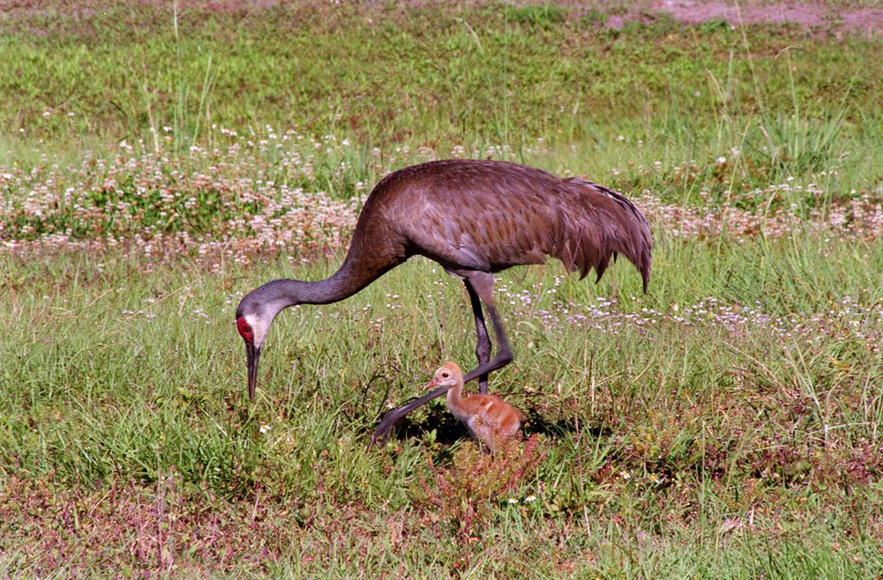
A Sandhill Crane searches for food with its still-fuzzy fledgling by its side. The two, along with another adult crane, have been seen wandering the grassy areas in the KSC Launch Complex 39 area. Sandhill cranes range from Siberia, Alaska and Arctic islands to Michigan, Minnesota and California; from Florida to Texas. They prefer large freshwater marshes, prairie ponds and marshy tundra. KSC shares a boundary with the Merritt Island National Wildlife Refuge, which encompasses 92,000 acres that are a habitat for more than 331 species of birds, 31 mammals, 117 fishes, and 65 amphibians and reptiles. The marshes and open water of the refuge provide wintering areas for 23 species of migratory waterfowl, as well as a year-round home for great blue herons, great egrets, wood storks, cormorants, brown pelicans and other species of marsh and shore birds, as well as a variety of insects
While the sandhill crane parents search for food in front of the Vehicle Assembly Building, their still-featherless baby nearby tests its voice. The cranes have been a constant sight in the Launch Complex 39 area during the month of May. Sandhill cranes range from Siberia, Alaska and Arctic islands to Michigan, Minnesota and California; from Florida to Texas. They prefer large freshwater marshes, prairie ponds and marshy tundra. KSC shares a boundary with the Merritt Island National Wildlife Refuge, which encompasses 92,000 acres that are a habitat for more than 331 species of birds, 31 mammals, 117 fishes, and 65 amphibians and reptiles. The marshes and open water of the refuge provide wintering areas for 23 species of migratory waterfowl, as well as a year-round home for great blue herons, great egrets, wood storks, cormorants, brown pelicans and other species of marsh and shore birds, as well as a variety of insects
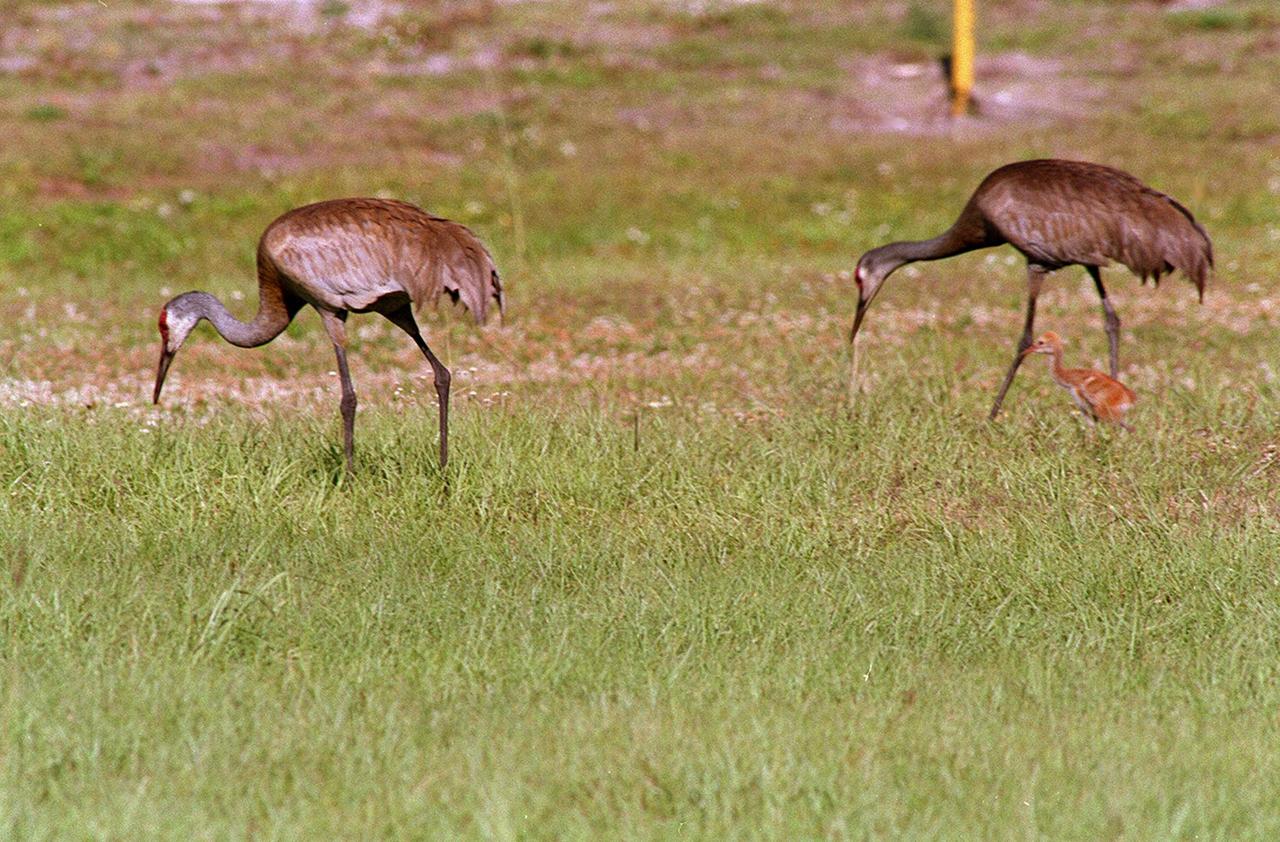
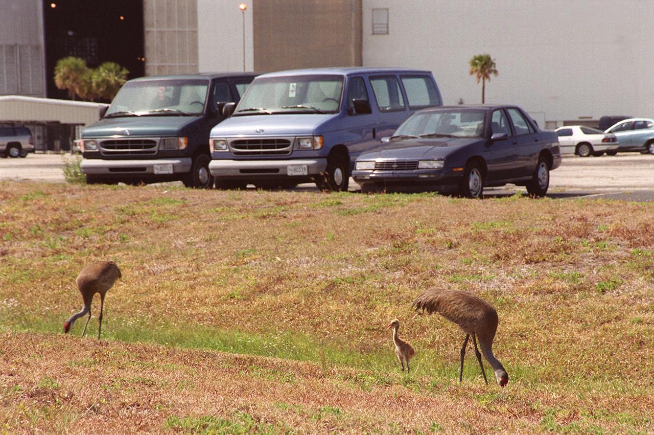
A pair of Sandhill Cranes searches for food with their still-fluffy fledgling close by. The trio have been seen wandering the grassy areas in the KSC Launch Complex 39 area. Sandhill cranes range from Siberia, Alaska and Arctic islands to Michigan, Minnesota and California; from Florida to Texas. They prefer large freshwater marshes, prairie ponds and marshy tundra. KSC shares a boundary with the Merritt Island National Wildlife Refuge, which encompasses 92,000 acres that are a habitat for more than 331 species of birds, 31 mammals, 117 fishes, and 65 amphibians and reptiles. The marshes and open water of the refuge provide wintering areas for 23 species of migratory waterfowl, as well as a year-round home for great blue herons, great egrets, wood storks, cormorants, brown pelicans and other species of marsh and shore birds, as well as a variety of insects

A Sandhill Crane searches for food with its still-fuzzy fledgling by its side. The two, along with another adult crane, have been seen wandering the grassy areas in the KSC Launch Complex 39 area. Sandhill cranes range from Siberia, Alaska and Arctic islands to Michigan, Minnesota and California; from Florida to Texas. They prefer large freshwater marshes, prairie ponds and marshy tundra. KSC shares a boundary with the Merritt Island National Wildlife Refuge, which encompasses 92,000 acres that are a habitat for more than 331 species of birds, 31 mammals, 117 fishes, and 65 amphibians and reptiles. The marshes and open water of the refuge provide wintering areas for 23 species of migratory waterfowl, as well as a year-round home for great blue herons, great egrets, wood storks, cormorants, brown pelicans and other species of marsh and shore birds, as well as a variety of insects

A pair of Sandhill Cranes searches for food with their still-fluffy fledgling close by. The trio have been seen wandering the grassy areas in the KSC Launch Complex 39 area. Sandhill cranes range from Siberia, Alaska and Arctic islands to Michigan, Minnesota and California; from Florida to Texas. They prefer large freshwater marshes, prairie ponds and marshy tundra. KSC shares a boundary with the Merritt Island National Wildlife Refuge, which encompasses 92,000 acres that are a habitat for more than 331 species of birds, 31 mammals, 117 fishes, and 65 amphibians and reptiles. The marshes and open water of the refuge provide wintering areas for 23 species of migratory waterfowl, as well as a year-round home for great blue herons, great egrets, wood storks, cormorants, brown pelicans and other species of marsh and shore birds, as well as a variety of insects

A family of sandhill cranes searches for food on the grounds near the Vehicle Assembly Building. The cranes have been a constant sight in the Launch Complex 39 area during the month of May. Sandhill cranes range from Siberia, Alaska and Arctic islands to Michigan, Minnesota and California; from Florida to Texas. They prefer large freshwater marshes, prairie ponds and marshy tundra. KSC shares a boundary with the Merritt Island National Wildlife Refuge, which encompasses 92,000 acres that are a habitat for more than 331 species of birds, 31 mammals, 117 fishes, and 65 amphibians and reptiles. The marshes and open water of the refuge provide wintering areas for 23 species of migratory waterfowl, as well as a year-round home for great blue herons, great egrets, wood storks, cormorants, brown pelicans and other species of marsh and shore birds, as well as a variety of insects

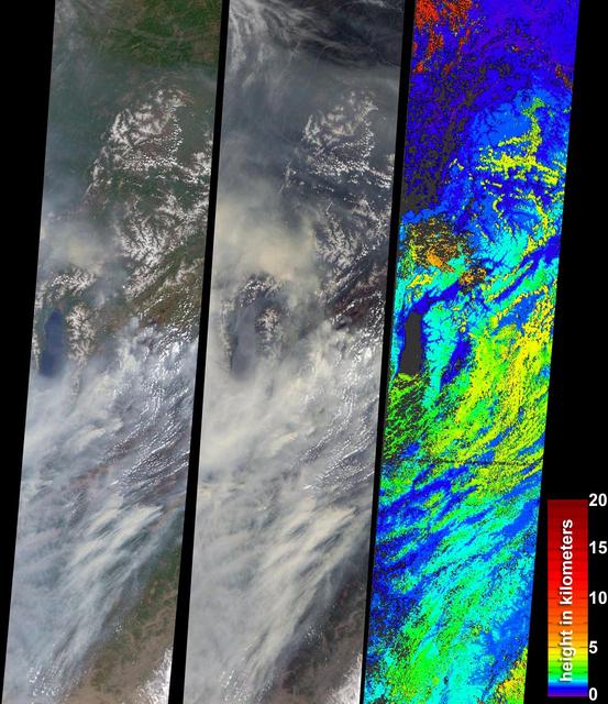
On Oct. 6, 2018, NASA's Terra satellite became one of a handful of NASA satellite ever to complete 100,000 orbits. Launched in 1999, Terra and its five scientific instruments were originally slated to last six years. More than 18 years later, the Multi-angle Imaging SpectroRadiometer (MISR), built by NASA's Jet Propulsion Laboratory in Pasadena, California, and other instruments on Terra are still collecting data and are expected to continue into the 2020s, limited only by the amount of fuel in the spacecraft. MISR carries nine cameras that view the sunlit Earth simultaneously at widely spaced angles, providing global coverage with high spatial detail. The left image shows dusk falling over snowy Queen Maud Land, Antarctica, at the end of orbit 99,999, as captured by MISR's 70-degree backward-looking camera. On the right is MISR's first view from orbit 100,000, taken by its 70-degree forward-looking camera as sunrise illuminated clouds over the Kara Sea, north of Siberia. Over the years, researchers have used MISR's observations to construct a variety of global data sets that have advanced our understanding of Earth. These include the heights of clouds and wildfire smoke, the amounts of dangerous pollutants in the atmosphere, the movements of global wind systems, and the health of vegetation. The instrument remains as healthy as it was in 1999. https://photojournal.jpl.nasa.gov/catalog/PIA22836
Siberian Ribbons - June 15th, 2005 Description: Vivid colors and bizarre shapes come together in an image that could be an imaginative illustration for a fantasy story. This labyrinth of exotic features is present along the edge of Russia's Chaunskaya Bay (vivid blue half circle) in northeastern Siberia. Two major rivers, the Chaun and Palyavaam, flow into the bay, which in turn opens into the Arctic Ocean. Ribbon lakes and bogs are present throughout the area, created by depressions left by receding glaciers. Credit: USGS/NASA/Landsat 5 To learn more about the Landsat satellite go to: <a href="http://landsat.gsfc.nasa.gov/" rel="nofollow">landsat.gsfc.nasa.gov/</a> <b><a href="http://www.nasa.gov/centers/goddard/home/index.html" rel="nofollow">NASA Goddard Space Flight Center</a></b> enables NASA’s mission through four scientific endeavors: Earth Science, Heliophysics, Solar System Exploration, and Astrophysics. Goddard plays a leading role in NASA’s accomplishments by contributing compelling scientific knowledge to advance the Agency’s mission. <b>Follow us on <a href="http://twitter.com/NASA_GoddardPix" rel="nofollow">Twitter</a></b> <b>Join us on <a href="http://www.facebook.com/pages/Greenbelt-MD/NASA-Goddard/395013845897?ref=tsd" rel="nofollow">Facebook</a></b>
ISS011-E-06717 (22 May 2005) --- Uralsk, Kazakhstan is featured in this image photographed by an Expedition 11 crew member on the international space station. The rough boundary between Europe and Asia is defined by the Ural River and the Ural Mountains to its north. The Ural River flows to the great inland Caspian Sea, and gives its name to the major city of Uralsk (population approximately 250,000) on its banks. Lying just inside the Kazakh border with Russia, Uralsk is an agricultural and industrial center, and important trade stop since the early 1600s. Barge traffic has passed up and down the Ural River between the Caspian Sea and the Ural Mountains for centuries. Today it is one of the major entry points for rail traffic from Europe to Siberia, servicing the many new oil fields in the Caspian basin and the industrial cities of the southern Urals. This view shows the sunglint (light reflected from the water surface towards the observer) on the rivers, lakes and ponds of the Ural floodplain (right side of image) and that of a tributary, the Chogan River (left side of image). The cityscape of Uralsk, on the headland between the two, is relatively difficult to see because the water and sunglint dominate the scene.
ISS011-E-06712 (22 May 2005) --- Uralsk, Kazakhstan is featured in this image photographed by an Expedition 11 crew member on the international space station. The rough boundary between Europe and Asia is defined by the Ural River and the Ural Mountains to its north. The Ural River flows to the great inland Caspian Sea, and gives its name to the major city of Uralsk (population approximately 250,000) on its banks. Lying just inside the Kazakh border with Russia, Uralsk is an agricultural and industrial center, and important trade stop since the early 1600s. Barge traffic has passed up and down the Ural River between the Caspian Sea and the Ural Mountains for centuries. Today it is one of the major entry points for rail traffic from Europe to Siberia, servicing the many new oil fields in the Caspian basin and the industrial cities of the southern Urals. Numerous details are visible in the photo, including the city margin, city blocks and even the causeway and individual buildings. Part of the smaller sister city of Zashaghan can be seen on the opposite bank (bottom). The green vegetated parts of the floodplains and black inundated parts (lower left, bottom image) stand out clearly. The brown Ural River waters contrast with the darker color of its tributary, the Chogan River (lower image).
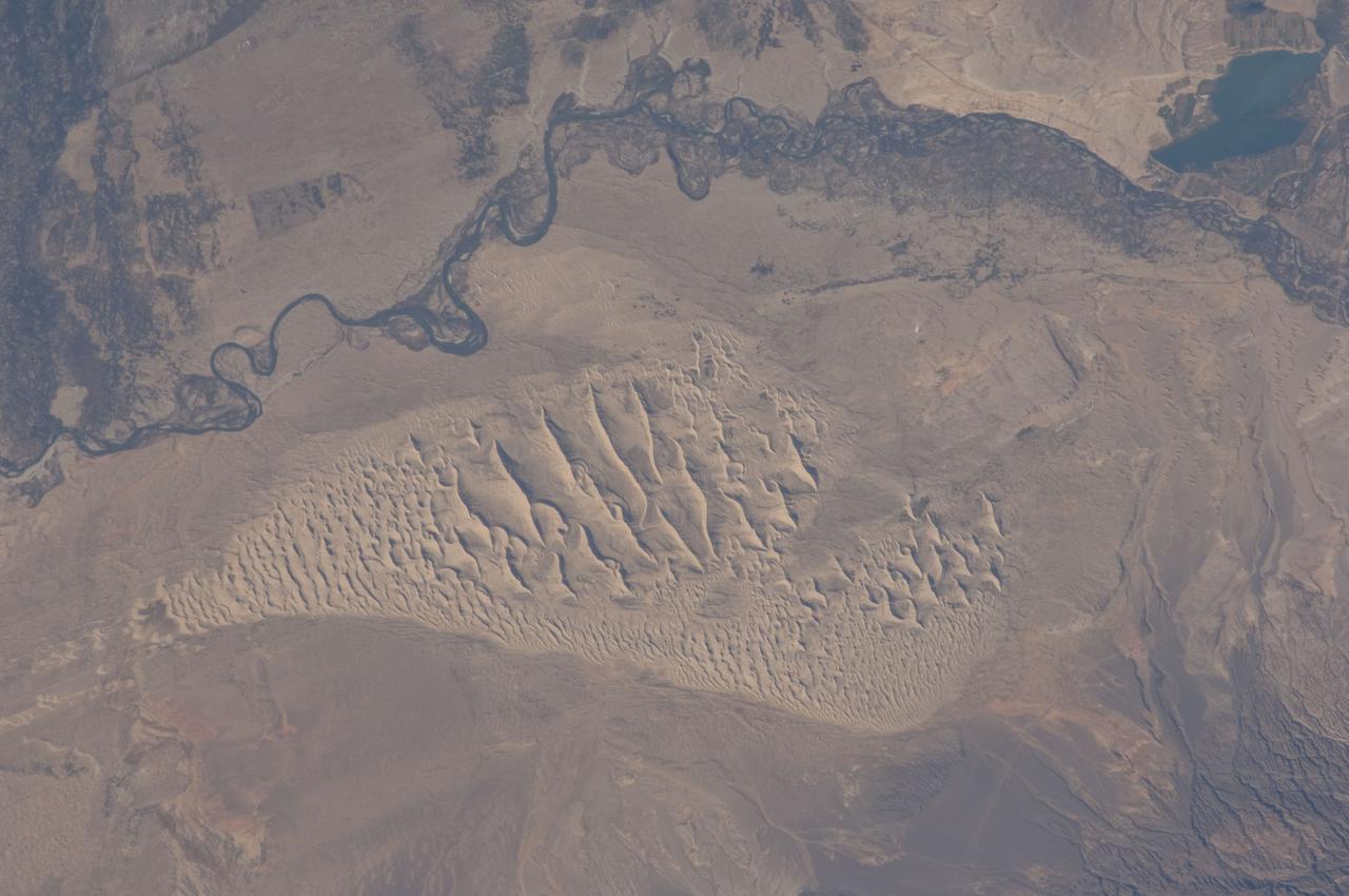
ISS028-E-044444 (8 Sept. 2011) --- This image, photographed by an Expedition 28 crew member on the International Space Station, highlights a sand dune field within the Burqin-Haba River-Jimunai Desert near the borders of China, Mongolia, Russia and Kazakhstan. The dune field (approximately 32 kilometers long) is located immediately to the west-northwest of the city of Burqin (not shown), and is part of the Junggar Basin, a region of active petroleum production in northwestern China. The Irtysh River, with associated wetlands and riparian vegetation (appearing grey-green in the image) flows from its headwaters in the Altay Mountains to the east towards Siberia to the west (right to left). Tan sandy linear dunes at center on the south side of the Irtysh River dominate the view. The linear dunes are formed from mobile barchan (crescent-shaped) dunes moving from left to right in this view; the barchans eventually merge to form the large linear dunes some of which reach 50-100 meters in height. Sand moving along the southern edge of the dune field appears to be feeding a southeastern lobe with a separate population of linear dunes (lower right). The Burqin-Haba River-Jimunai Desert area also includes darker gravel covered surfaces that form pavements known locally as gobi. These are somewhat indistinguishable from vegetated areas arresting some of the dunes at the resolution of the image, but tend to be located on the flat regions between the dunes.
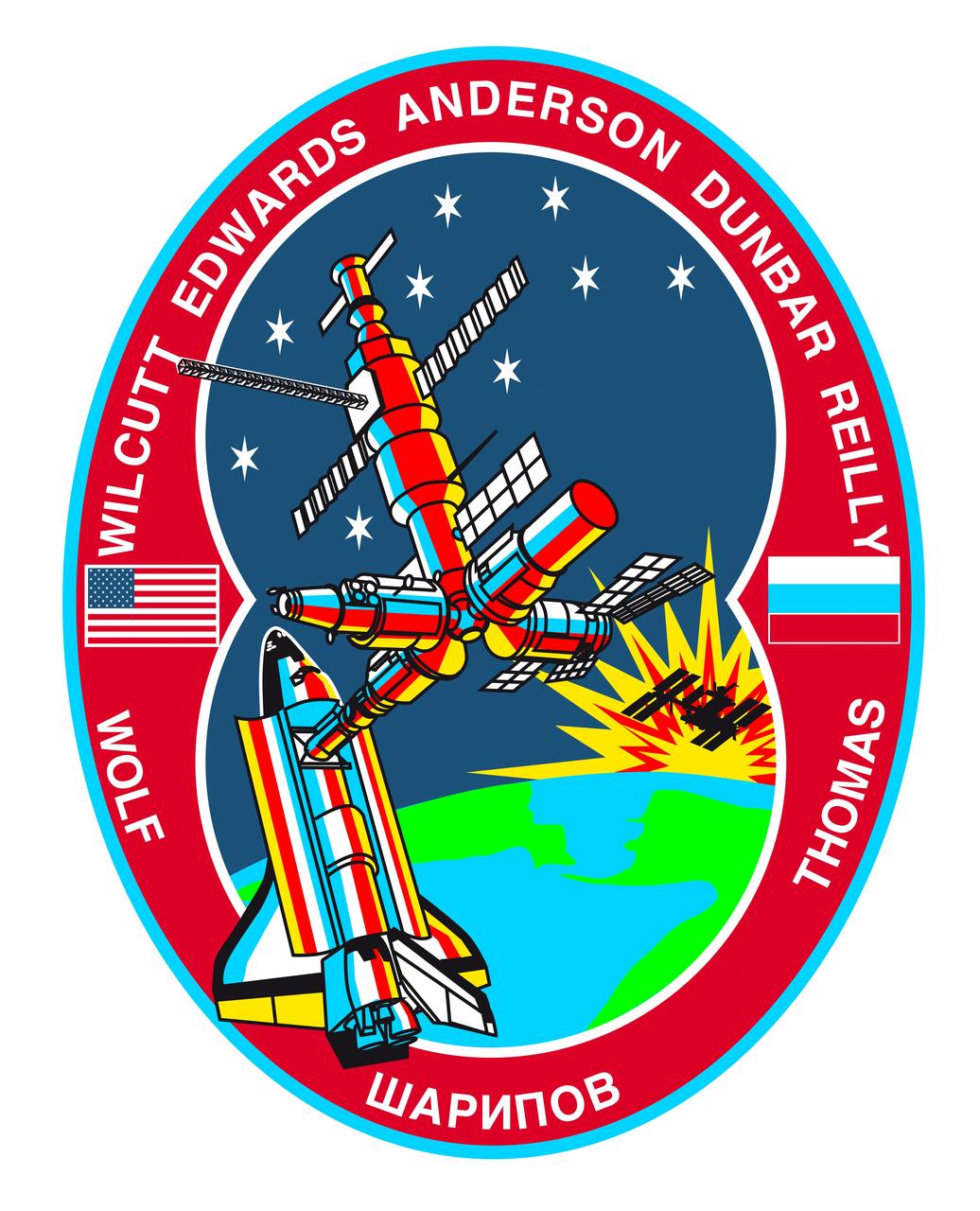
STS089-S-001 (October 1997) --- The link between the United States and Russia is symbolically represented by the space shuttle Endeavour and Russia?s Mir Space Station orbiting above the Bering Strait between Siberia and Alaska. The success of the joint United States-Russian missions is depicted by the space shuttle and Mir colored by the rising sun in the background. A shadowed representation of the International Space Station (ISS) rising with the sun represents the future program for which the Shuttle-Mir missions are prototypes. The inside rim of the insignia describes the outline of the number eight representing STS-89 as the eighth Shuttle/Mir docking mission. The nine stars represent the nine joint missions to be flown of the program and ? when combined with the number eight in the rim -- reflect the mission number. The nine stars also symbolize the children of the crew members who will be the future beneficiaries of the joint development work of the space programs of the two countries. Along the rim are the crew members? names with David A. Wolf?s name on the left and Andrew S. W. Thomas? name on the right, the returning and upgoing cosmonaut guest researcher crew members. In between and at the bottom is the name of Salizan S. Sharipov, mission specialist representing Russian Space Agency (RSA), in Cyrillic alphabet. The other crew members are Terrence W. Wilcutt, commander; Joe F. Edwards Jr., pilot; and mission specialists Michael P. Anderson, Bonnie J. Dunbar, and James F. Reilly. The red, white and blue of the rim reflect the colors of the American and Russian flags which are also represented in the rim on either side of the joined spacecraft. The NASA insignia design for space shuttle flights is reserved for use by the astronauts and for other official use as the NASA Administrator may authorize. Public availability has been approved only in the forms of illustrations by the various news media. When and if there is any change in this policy, which is not anticipated, the change will be publicly announced. Photo credit: NASA

In the STS-89 crew insignia, the link between the United States and Russia is symbolically represented by the Space Shuttle Endeavour and Russia's Mir Space Station orbiting above the Bering Strait between Siberia and Alaska. The success of the joint United States-Russian missions is depicted by the Space Shuttle and Mir colored by the rising sun in the background. A shadowed representation of the International Space Station (ISS) rising with the sun represents the future program for which the Shuttle-Mir missions are prototypes. The inside rim of the insignia describes the outline of the number eight representing STS-89 as the eighth Shuttle/Mir docking mission. The nine stars represent the nine joint missions to be flown of the program and when combined with the number eight in the rim, reflect the mission number. The nine stars also symbolize the children of the crew members who will be the future beneficiaries of the joint development work of the space programs of the two countries. Along the rim are the crew members' names with David A. Wolf's name on the left and Andrew S. W. Thomas' name on the right, the returning and upgoing cosmonaut guest researcher crew members. In between and at the bottom is the name of Salizan S. Sharipov, payload specialist representing Russian Space Agency (RSA), in Cyrillic alphabet. The other crew members are Terrence W. Wilcutt, commander; Joe F. Edwards, Jr., pilot; and mission specialists Michael P. Anderson, Bonnie J. Dunbar, and James F. Reilly. The red, white and blue of the rim reflect the colors of the American and Russian flags which are also represented in the rim on either side of the joined spacecraft.

The rotational axis of Mars is currently tilted by about 25 degrees, very similar to that of the Earth (at 23.4 degrees). However, while Earth's axial tilt (also known as "obliquity") tends to change very slightly over time (almost 3 degrees in 40,000 year-cycles), the obliquity of Mars is much more chaotic and varies widely from 0 to almost 60 degrees! The fact that it is currently similar to that of the Earth is merely a coincidence. Currently, water-ice is stable on the Martian surface only in the polar regions. However, during times of "high obliquity," that stability shifts towards the equatorial regions. We see evidence for recent periods of high obliquity on Mars in the form of features common in the mid-latitude regions, which planetary scientists call "viscous flow features," "lobate debris aprons," or "lineated valley fills." These are all scientifically conservative ways of describing features on Mars that resemble mountain glaciers on Earth. We now know from radar observations, particularly using the SHARAD instrument on board the Mars Reconnaissance Orbiter, that these features are really composed of mixtures of pure ice and dust, and as a result, many scientists have started using the term "glacier-like forms" (GLF) to describe some of them. The main reason that these feature are still present for us to observe nowadays-despite the inhospitable conditions for water ice in these latitudes-is that these "glaciers" are covered by thin layers of dust, which protect them from the atmosphere of Mars and prevents, or significantly slows down, the loss of ice through sublimation to the atmosphere. However, if we were to take a look at this image of a "lobate debris apron," we will see that some areas show numerous depressions, which suggests that these areas have lost some of the ice creating these "deflation features." In addition, if we zoom in on one of these depressions, we will see surface polygonal patterns, which are common in cold regions on Earth (such as Alaska, northern Canada, and Siberia) and are indicators of shallow sub-surface water-ice. http://photojournal.jpl.nasa.gov/catalog/PIA21065
The Kuril Islands are a string of volcanically-formed islands that stretch between Russia and Japan, separating the North Pacific Ocean from the Sea of Okhotsk. Subject to the cold, moist breezes from the North Atlantic, and the frigid air from Siberia, the climate is severe, with frequent storms, and ever-present winds, which often reach hurricane strength. Cloudy, windy conditions are common. On June 1, 2015 the Moderate Resolution Imaging Spectroradiometer (MODIS) aboard NASA’s Aqua satellite captured this true-color image as it passed over the Kuril Islands. Clouds curl into the center of a storm system, bringing strong winds to the region. As the winds scrape over the tall volcanic peaks of the Kuril Islands, they become turbulent air behind the islands. The turbulence disturbs the cloudbank, etching its passage into a striking pattern that can be seen from space. This particular pattern is called “ship-waved-shaped wave clouds”, because the pattern can be likened to that formed behind a ship cutting through a smooth ocean. On the windward side of the Kuril Islands, the cloud bank is generally smooth, with streaks that are lined up parallel to the movement of the wind, blowing from the west and towards the east. Behind the tall volcanic peaks of the islands, V’s fan out on the leeward side, illustrating the flow of the turbulent air. Image Credit: Jeff Schmaltz, MODIS Land Rapid Response Team, NASA GSFC <b><a href="http://www.nasa.gov/audience/formedia/features/MP_Photo_Guidelines.html" rel="nofollow">NASA image use policy.</a></b> <b><a href="http://www.nasa.gov/centers/goddard/home/index.html" rel="nofollow">NASA Goddard Space Flight Center</a></b> enables NASA’s mission through four scientific endeavors: Earth Science, Heliophysics, Solar System Exploration, and Astrophysics. Goddard plays a leading role in NASA’s accomplishments by contributing compelling scientific knowledge to advance the Agency’s mission. <b>Follow us on <a href="http://twitter.com/NASAGoddardPix" rel="nofollow">Twitter</a></b> <b>Like us on <a href="http://www.facebook.com/pages/Greenbelt-MD/NASA-Goddard/395013845897?ref=tsd" rel="nofollow">Facebook</a></b> <b>Find us on <a href="http://instagrid.me/nasagoddard/?vm=grid" rel="nofollow">Instagram</a></b>

Located off the east coast of Russia, the Sea of Okhotsk stretches down to 45 degrees North latitude, and sea ice forms regularly in the basin. In fact, it is the lowest latitude for seasonal sea ice formation in the world. On January 4, 2015, the Moderate Resolution Imaging Spectroradiometer (MODIS) on NASA’s Terra satellite captured this true-color image of the ice-covered Sea of Okhotsk. Every winter, winds from East Siberia, frigid air temperatures, and a large amount of freshwater flowing out from rivers promote the formation of sea ice in the region. Much of the freshwater comes from the Amur River, one of the ten longest rivers in the world. From year to year, variations in temperature and wind speed can cause large fluctuations in sea ice extent. The sea spans more than 1,500,000 square kilometers (600,000 square miles), and ice cover can spread across 50 to 90 percent of it at its annual peak. On average, that ice persists for 180 days. According to research published in 2014, the region's sea ice has been decreasing over a 34-year period. Annual ice production in the Sea of Okhotsk dropped by more than 11 percent from 1974 to 2008. The researchers suggest that this decline has, at least in part, "led to weakening of the overturning in the North Pacific." Water with less sea ice is fresher, less dense, and unable to sink and circulate as well as salty, dense water. A weakened circulation in the North Pacific has implications for the supply of nutrients, such as iron, that affect biological productivity. Credit: NASA/GSFC/Jeff Schmaltz/MODIS Land Rapid Response Team <b><a href="http://www.nasa.gov/audience/formedia/features/MP_Photo_Guidelines.html" rel="nofollow">NASA image use policy.</a></b> <b><a href="http://www.nasa.gov/centers/goddard/home/index.html" rel="nofollow">NASA Goddard Space Flight Center</a></b> enables NASA’s mission through four scientific endeavors: Earth Science, Heliophysics, Solar System Exploration, and Astrophysics. Goddard plays a leading role in NASA’s accomplishments by contributing compelling scientific knowledge to advance the Agency’s mission. <b>Follow us on <a href="http://twitter.com/NASAGoddardPix" rel="nofollow">Twitter</a></b> <b>Like us on <a href="http://www.facebook.com/pages/Greenbelt-MD/NASA-Goddard/395013845897?ref=tsd" rel="nofollow">Facebook</a></b> <b>Find us on <a href="http://instagram.com/nasagoddard?vm=grid" rel="nofollow">Instagram</a></b>
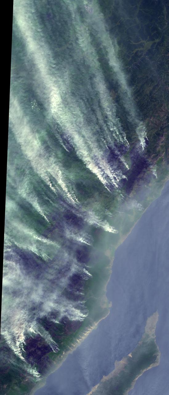
Smoke from Far Eastern Russia’s spring wildfires reached the Bering Sea by May 11, 2012. The Moderate Resolution Imaging Spectroradiometer aboard NASA’s Terra satellite passed over the region at 23:30 UTC on that same day and acquired this true-color image of a broad band of smoke stretching across the blue waters. In this image, the plume of smoke appears light gray while banks of cloud are bright white. Snow covers much of Kamchatka the land mass in the west. Karaginsky Island, just off Kamchatka’s eastern shore, is surrounded by sea ice. Clouds stream off the southwest shores of Beringa and Medny Islands. To the east, Attu Station, Alaska, is surrounded by cloud. In early May, numerous wildfires burned near Lake Baikal, in Siberia. These fires billowed heavy smoke across eastern Mongolia, China and Russia’s Far East. An image of the smoke and fires was captured on May 8 and appeared as the MODIS image of the day on May 11. That image can be viewed here: <a href="http://modis.gsfc.nasa.gov/gallery/individual.php?db_date=2012-05-11" rel="nofollow">modis.gsfc.nasa.gov/gallery/individual.php?db_date=2012-0...</a>. According to a model by the National Oceanic and Atmospheric Administration (NOAA), it is possible that smoke from the Lake Baikal region could take just a few days to reach the Bering Sea. Credit: NASA/GSFC/Jeff Schmaltz/MODIS Land Rapid Response Team <b><a href="http://www.nasa.gov/audience/formedia/features/MP_Photo_Guidelines.html" rel="nofollow">NASA image use policy.</a></b> <b><a href="http://www.nasa.gov/centers/goddard/home/index.html" rel="nofollow">NASA Goddard Space Flight Center</a></b> enables NASA’s mission through four scientific endeavors: Earth Science, Heliophysics, Solar System Exploration, and Astrophysics. Goddard plays a leading role in NASA’s accomplishments by contributing compelling scientific knowledge to advance the Agency’s mission. <b>Follow us on <a href="http://twitter.com/NASA_GoddardPix" rel="nofollow">Twitter</a></b> <b>Like us on <a href="http://www.facebook.com/pages/Greenbelt-MD/NASA-Goddard/395013845897?ref=tsd" rel="nofollow">Facebook</a></b> <b>Find us on <a href="http://instagrid.me/nasagoddard/?vm=grid" rel="nofollow">Instagram</a></b>