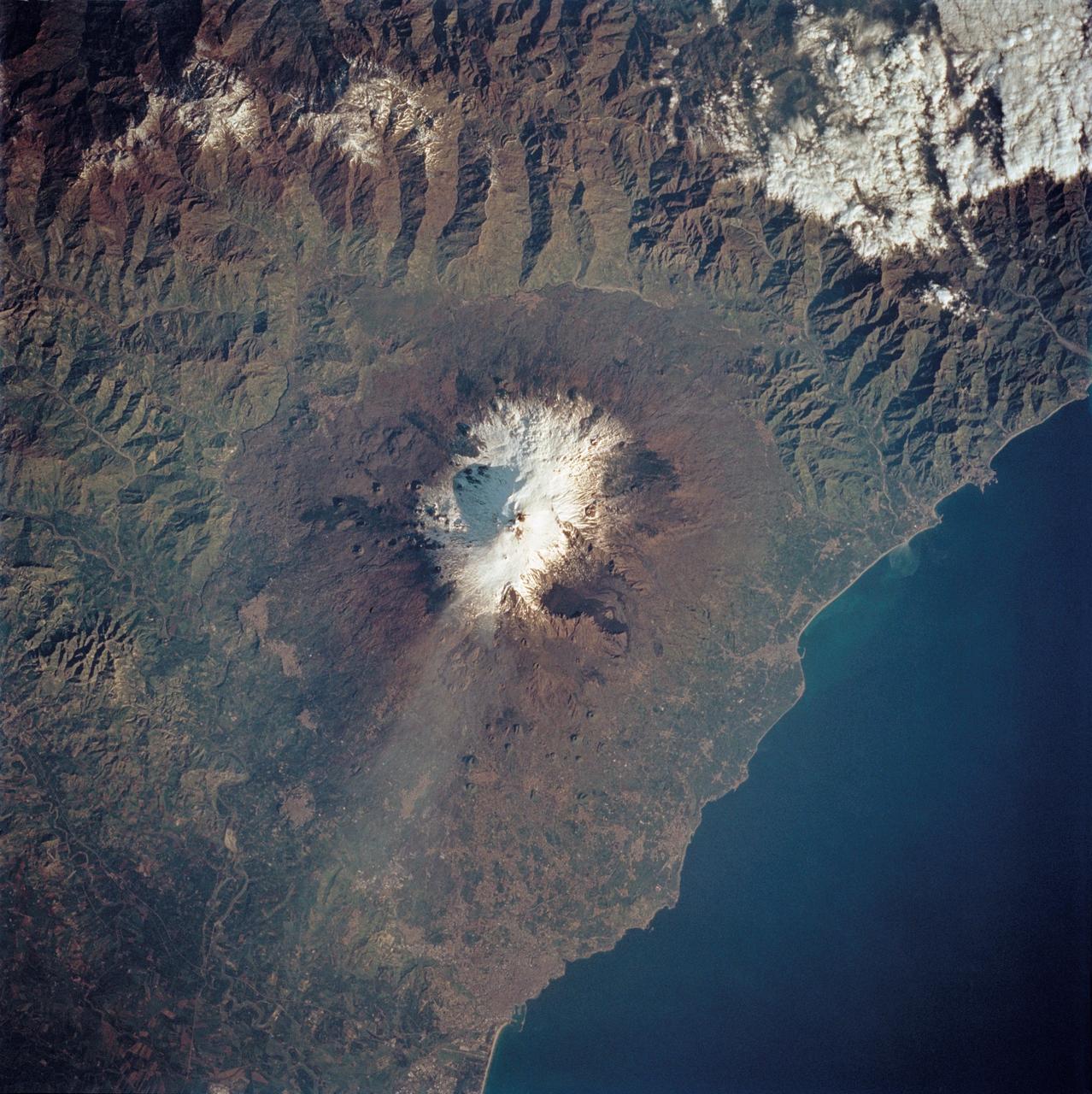
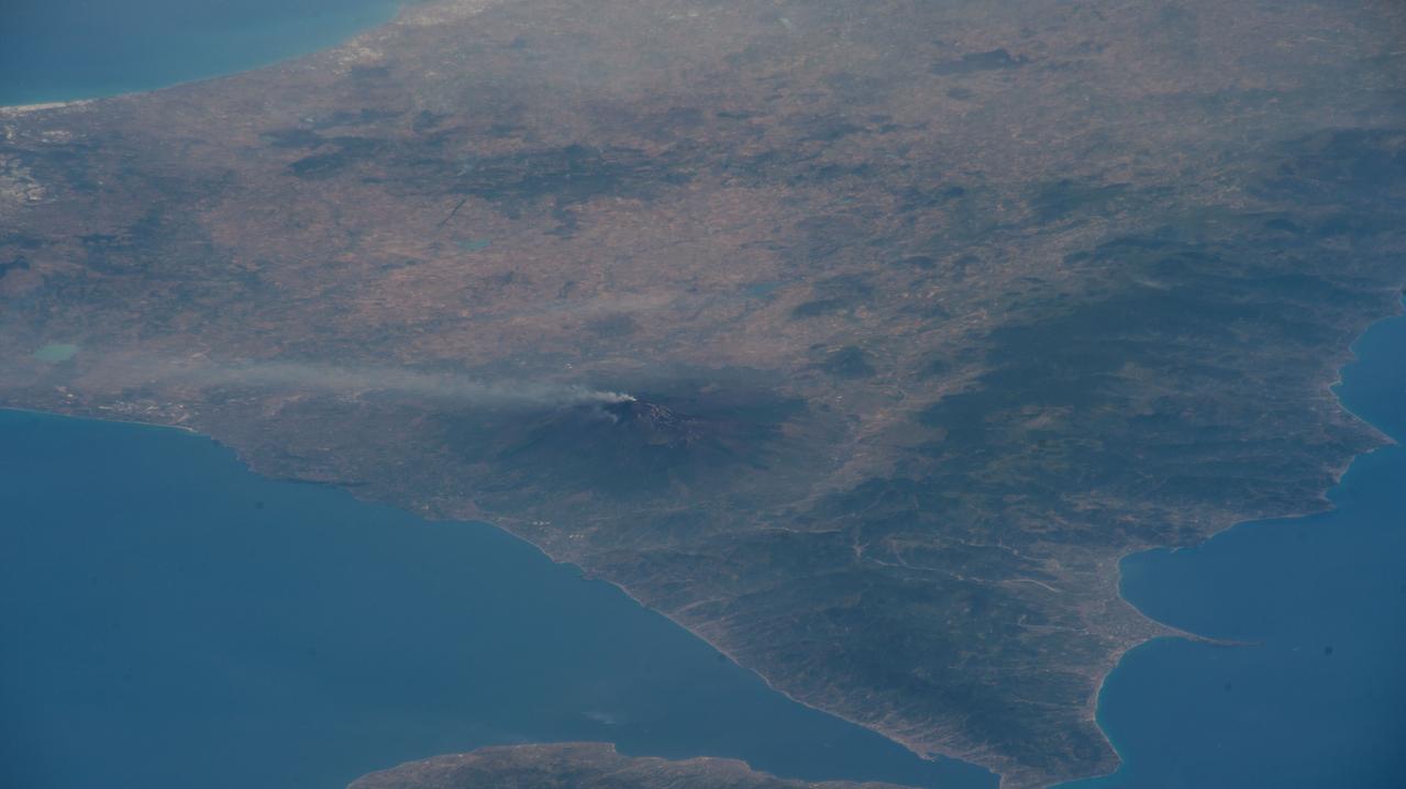
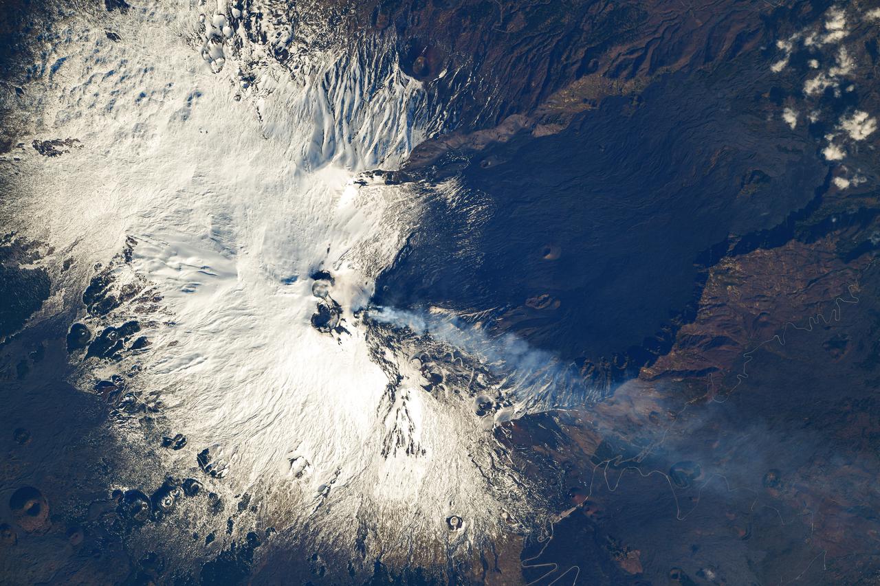
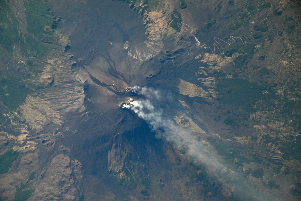
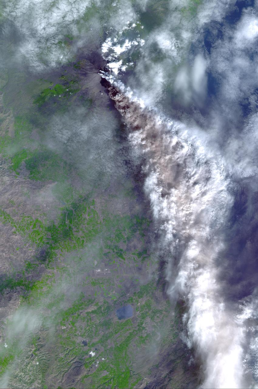
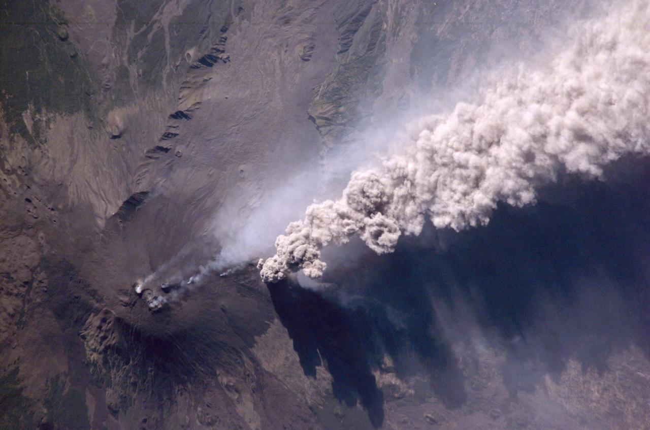
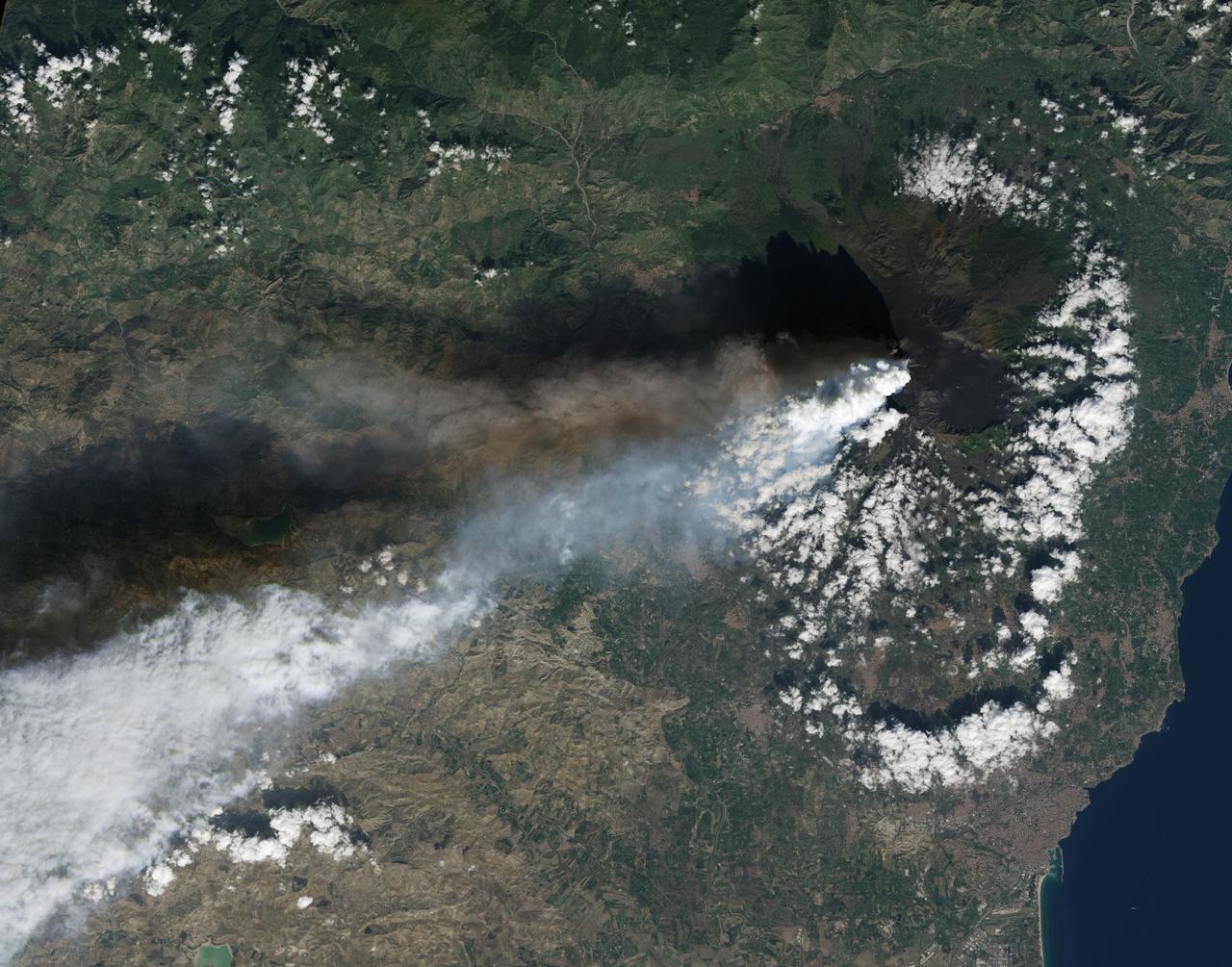
STS062-85-195 (4-18 March 1994) --- A thin plume of steam blows southward from the summit of Mt. Etna, the active volcano on the island of Sicily. The summit is capped with snow but the dark lava flow along the eastern flank (the 1991-93 flow) is clearly visible. The coastal city south of Etna is Catania.
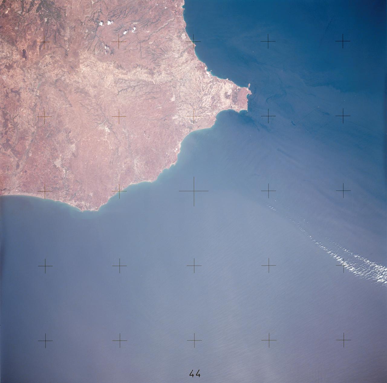
AST-17-1378 (20 July 1975) --- A near vertical view of the most southerly portion of the Island of Sicily in the Mediterranean Sea, as photographed from the Apollo spacecraft in Earth orbit during the joint U.S.-USSR Apollo-Soyuz Test Project mission. This view includes the towns of Gala, Pachino, Avela and Pozzalo. The photograph was taken at an altitude of 228 kilometers (141 statute miles) with a 70mm Hasselblad camera using high-definition aerial Ektachrome SO-242 type film.
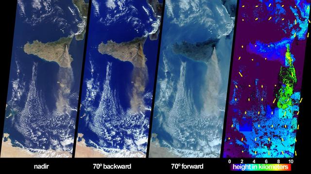
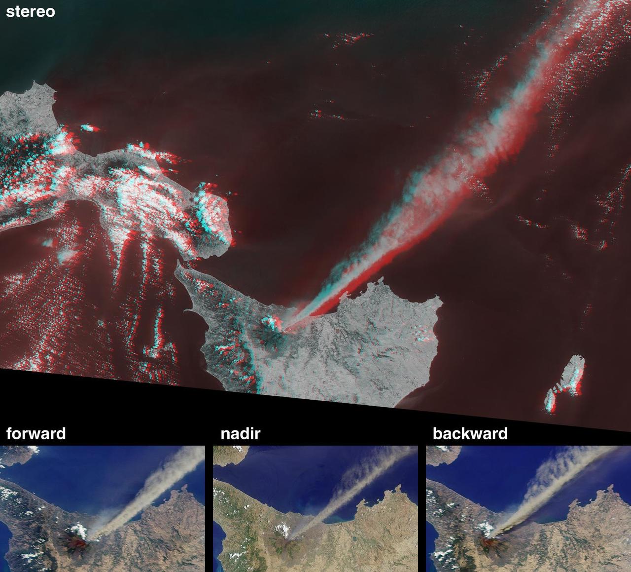
The height and southward extent of the ash plume emanating from Sicily Mount Etna volcano on October 27, 2002 are captured in these four image panels from NASA Terra spacecraft.
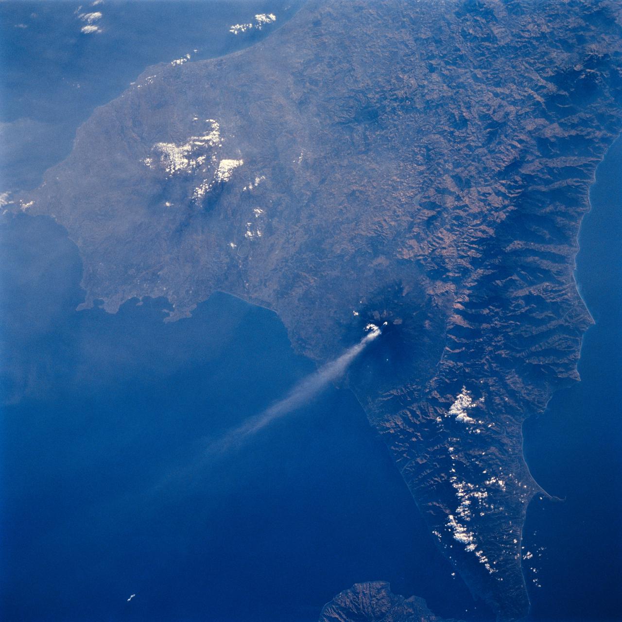
STS064-71-037 (9-20 Sept. 1994) --- Mt. Etna on Sicily displays a steam plume from its summit. Geologists attribute the volcano's existence to the collision of tectonic plates. Unlike the sudden, explosive eruption at Rabaul, Mt. Etna's activity is ongoing and is generally not explosive - Etna's slopes have been settled with villages and cultivated land for centuries. Other Mediterranean volcanoes (like Santorini) have experienced large catastrophic eruptions. Etna recently finished a two-year eruption (ending in 1993), marked by relatively gentle lava flows down the eastern flank. It has been continually degassing since then, according to the geologists, producing an omnipresent steam plume, as seen here. The 1993 flow is difficult to identify in this image because it lies within shadows on the eastern flank, but small cinder cones on the western flank mark earlier episodes of volcanic activity. Photo credit: NASA or National Aeronautics and Space Administration

SL3-87-355 (July-September 1973) --- A vertical view of the eastern coast of Sicily area is seen in this Skylab 3 Earth Resources Experiments Package S190-B (five-inch earth terrain camera) infrared photograph taken from the Skylab space station in Earth orbit. Mount Etna, the highest volcano in Europe (10,958 feet), is still active as evidenced by the thin plume of smoke emanating from its crest. (The altitude is approximate because the height of the volcano changes with each eruption). On the flanks of Etna recent lava flows appear black in contrast to the older flows and volcanic debris that are red. Numerous small, circular cinder cones on the flanks represent sites of previous eruptions. Catania, on the Mediterranean coast south of Etna, is the largest of several cities and villages which appear as light-gray patches on the lower slopes of the volcano. Plano de Catania, south of the city of Catania, is outlined by polygonal light and dark agricultural tracts. Several lakes, the largest of which is Lake Pozzillo, show up as dark blue in the photograph. The unusual colors in the picture are due to the use of color infrared film in which vegetation appears red. This is very evident on the slopes of Etna, in the Monti Nebrodi area at upper let, and in the local areas in the lower part of the picture. Studies of Mount Etna and related volcanic features will be undertaken by Professor Roberto Cassinis of Servizio Geologio d?Italia, Rome. Federal agencies participating with NASA on the EREP project are the Departments of Agriculture, Commerce, Interior, the Environmental Protection Agency and the Corps of Engineers. All EREP photography is available to the public through the Department of Interior?s Earth Resources Observation Systems Data Center, Sioux Falls, South Dakota, 57198. Photo credit: NASA
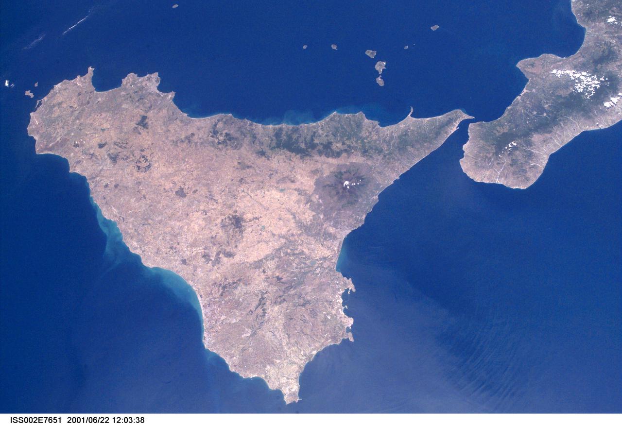
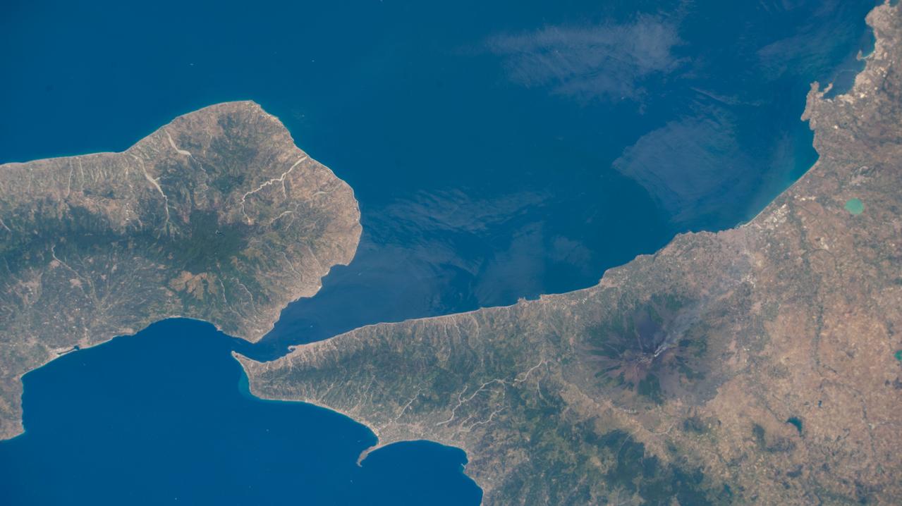
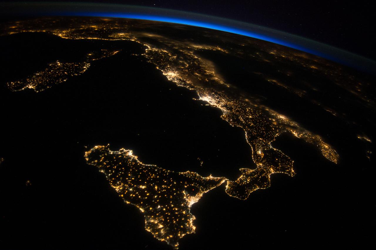
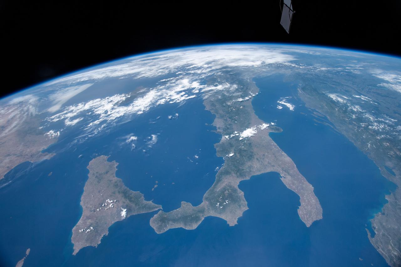
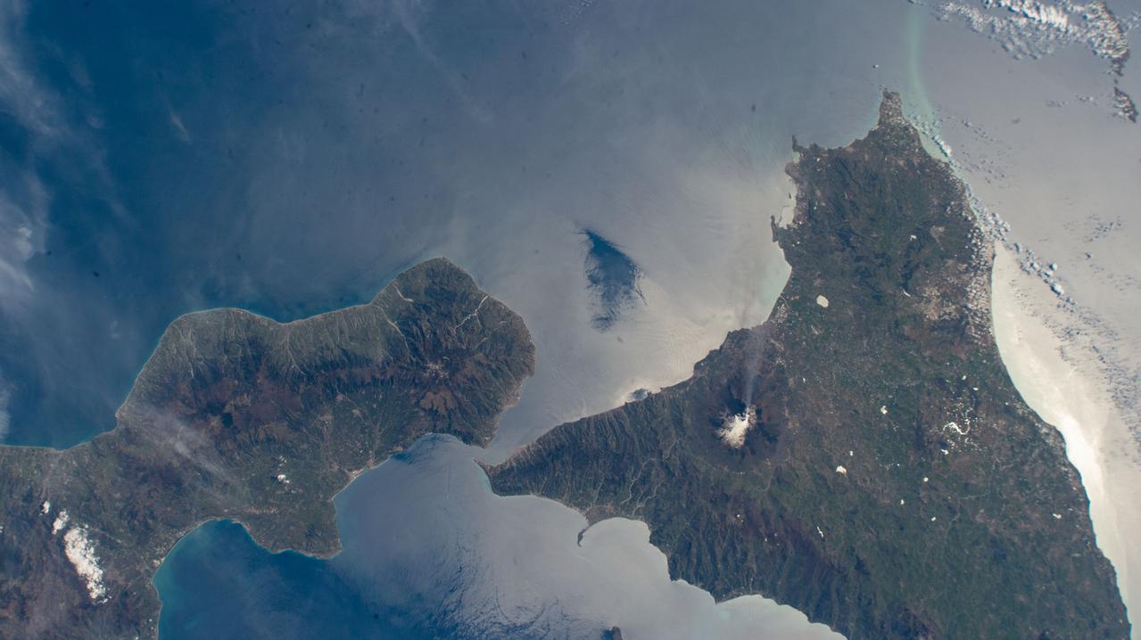
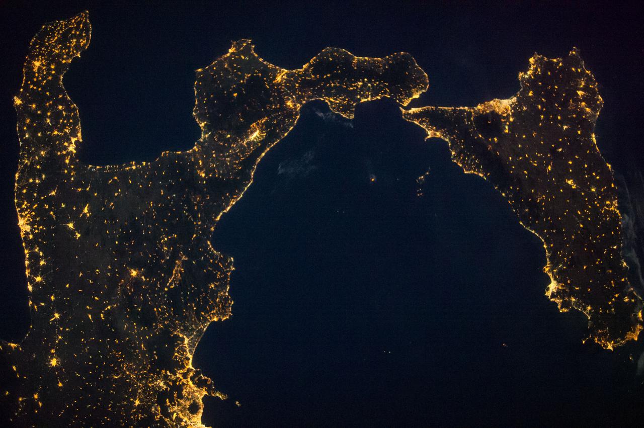
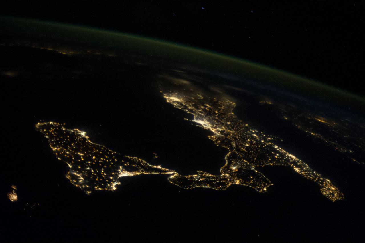
ISS002-E-7651 (22 June 2001) --- Sicily and the "toe" of Italy are featured in this Expedition Two digital still camera's nearly-vertical view from the International Space Station (ISS).
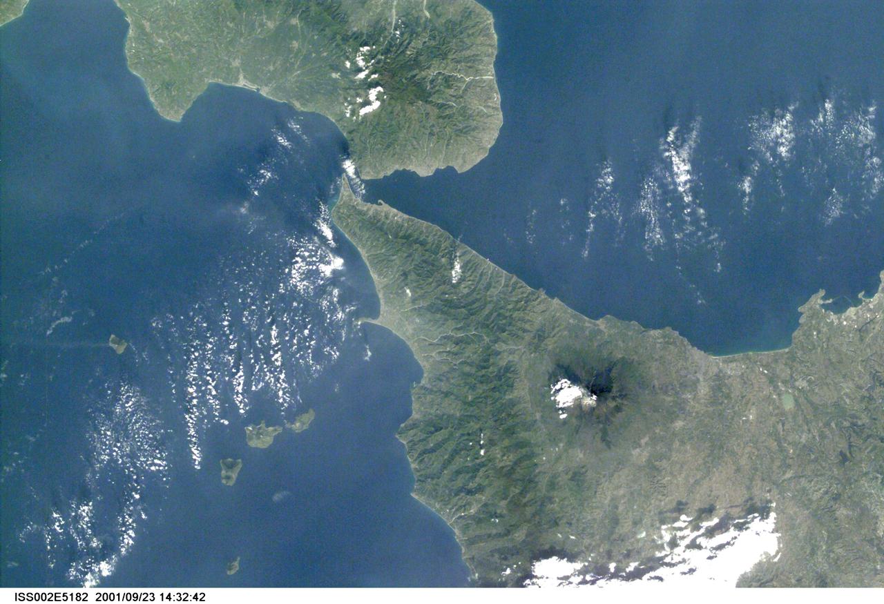
ISS002-E-5182 (March 2001) --- Part of the "toe" of Italy and Sicily are visible in this Expedition Two digital still camera's image.
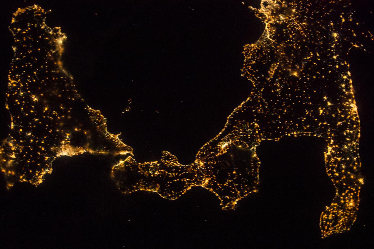
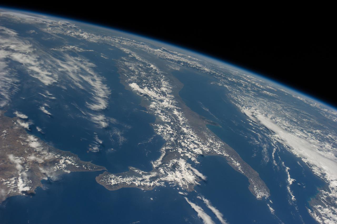
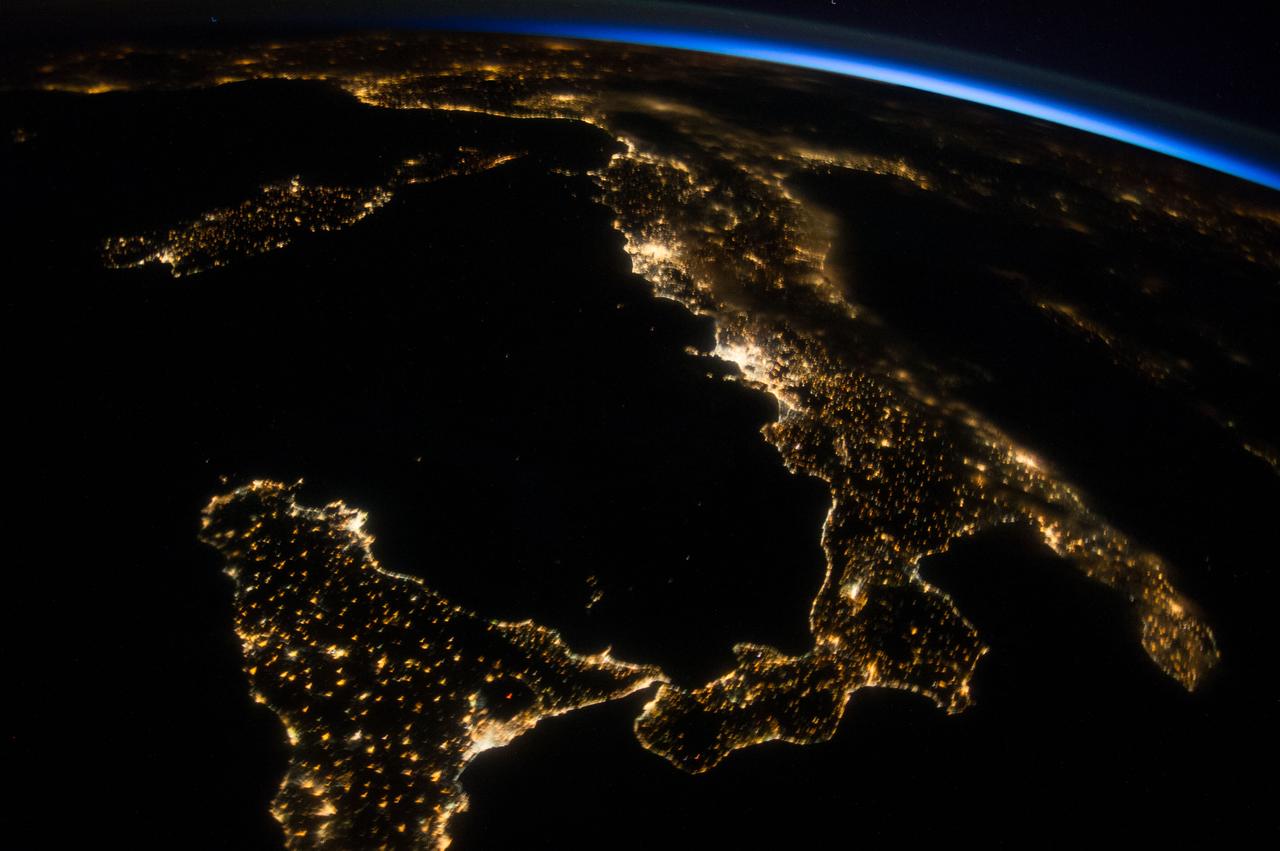
iss069e028451 (July 3, 2023) -- Sicily, the largest Mediterranean island and one of 20 regions of Italy, is photographed from the International Space Station as it orbited 258 miles above.

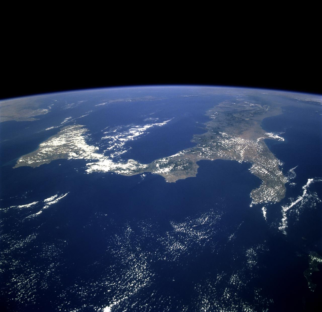
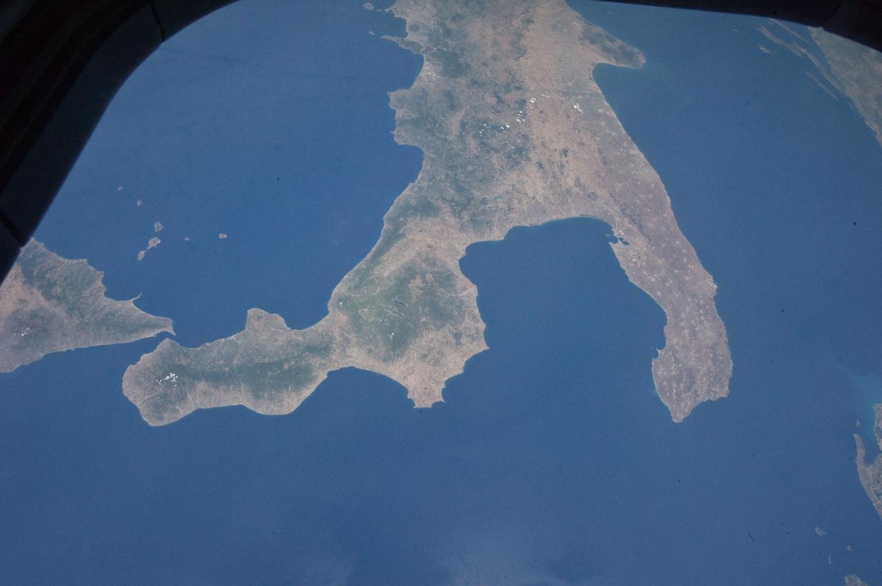
STS100-713-064 (19 April-1 May 2001) --- This southerly-looking view, captured with a 70mm camera onboard the Space Shuttle Endeavour, shows the triangular-shaped island of Sicily. With only very limited coastal plains the island's topography consists of rugged hills and low mountains. Snow-capped Mt. Etna, one of the world's most instrumented volcanoes, is visible near the northeast point of the island. Two other distinctive features in this image are the lighter-colored zone of suspended sediment in the water along the southern coast and, in the distance, the smaller islands of Malta.
Mt. Etna, a volcano on the island of Sicily, erupted on October 26, 2002, as seen by the Atmospheric Infrared Sounding System AIRS on NASA Aqua. http://photojournal.jpl.nasa.gov/catalog/PIA00355
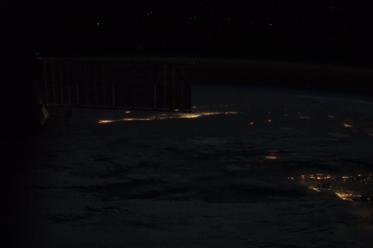
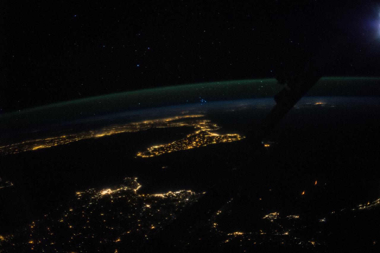
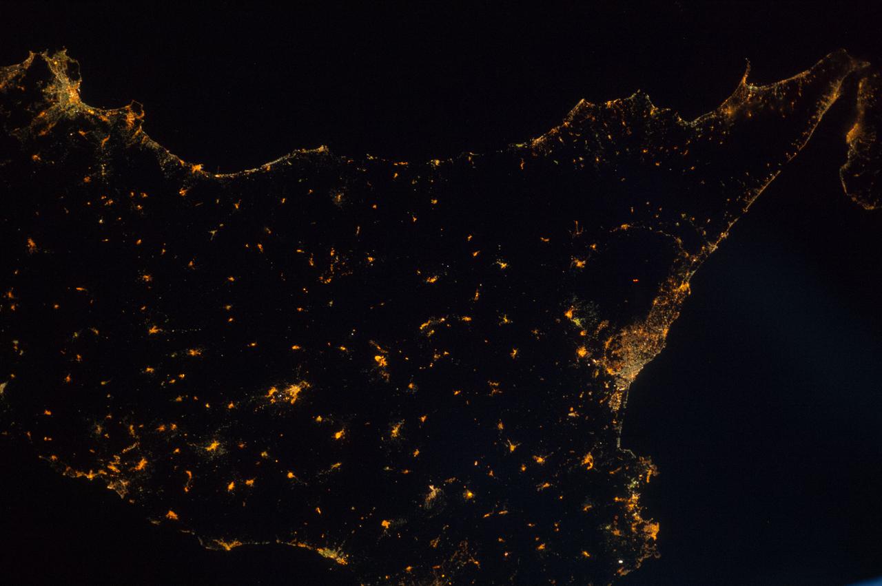
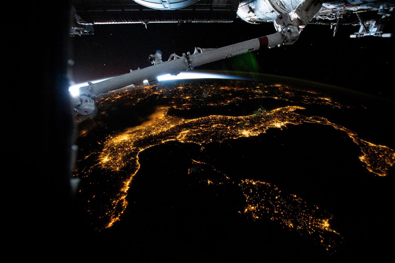
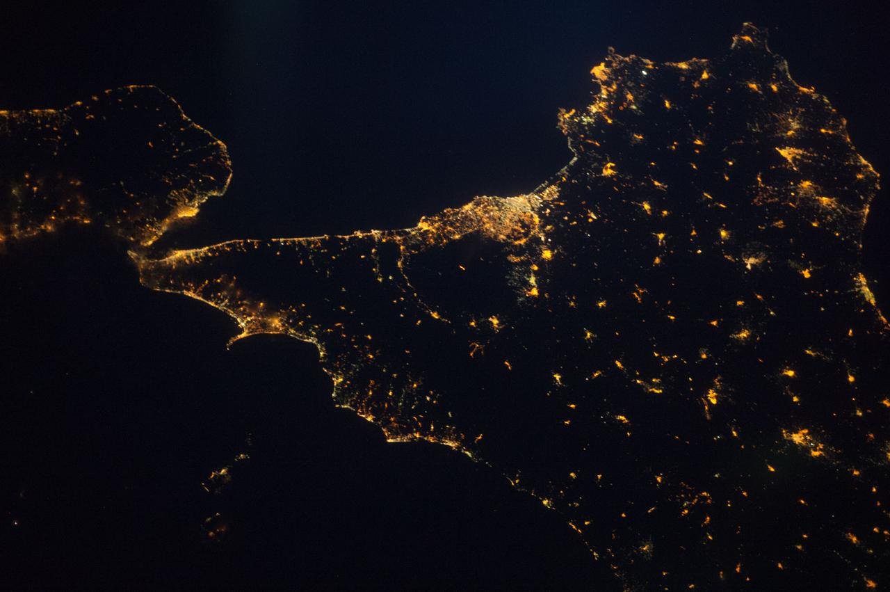
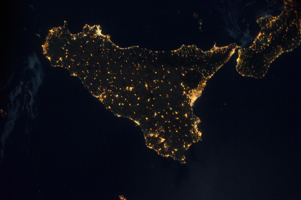
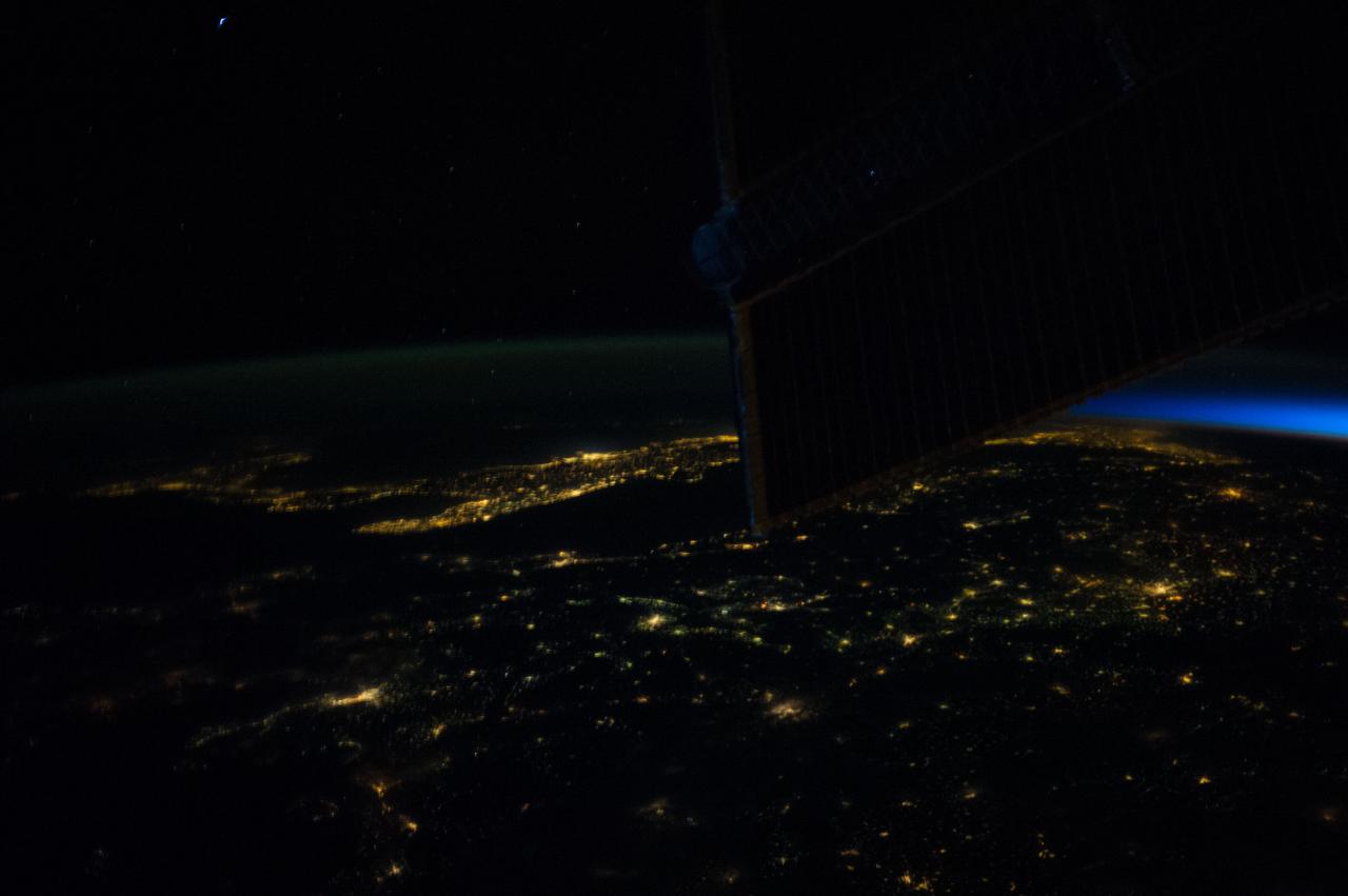
GMT333_21_50_Terry Virts_night sicily russia_131
This anaglyph from the MISR instrument aboard NASA Terra spacecraft captured the energetic eruption of Sicily Mount Etna volcano on October 29, 2002. 3D glasses are necessary to view this image.
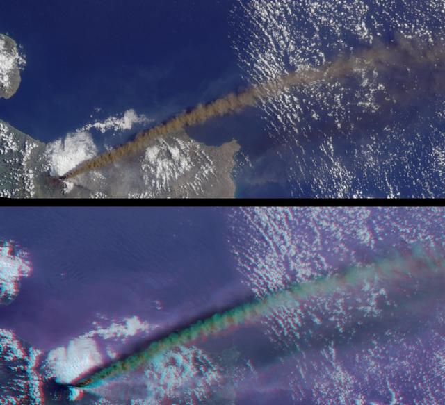
This anaglyph from the MISR instrument aboard NASA Terra spacecraft shows the eruption of Mt. Etna volcano located near the eastern coast of Sicily on July 22, 2001. 3D glasses are necessary to view this image.
This image acquired by NASA Terra spacecraft is of Mount Etna, on the Italian island of Sicily, Europe most active volcano, where its latest series of eruptions has continued for weeks.
iss067e107087 (June 2, 2022) --- The southern tip of the boot of Italy (left) and the island of Sicily are pictured from the International Space Station as it orbited 262 miles above the Mediterranean Sea. Mount Etna (lower right), Europe's tallest active volcano on the coast of Sicily, is visible billowing with activity.
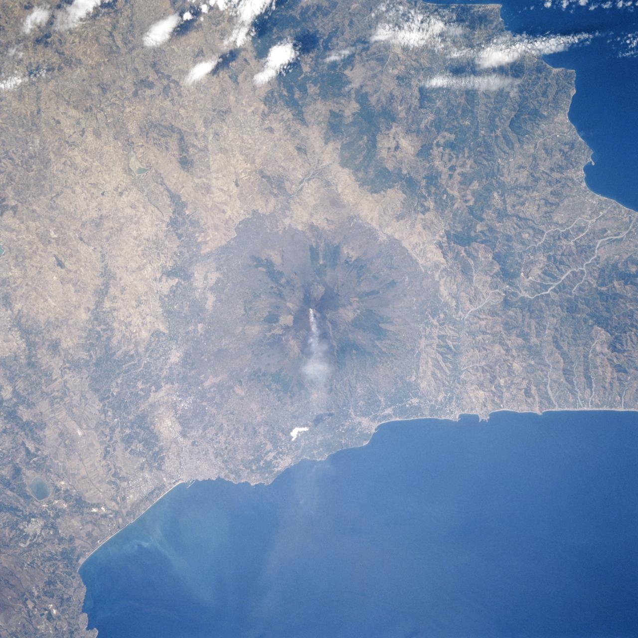
STS106-706-055 (8-20 September 2000) --- One of the STS-106 crew members on board the Space Shuttle Atlantis used a handheld 70mm camera to photograph this image of the Etna Volcano on Sicily. Mt. Etna is known as the volcano with the longest record of volcanic activity with the first being in 1500 BC. It has erupted many times since then and is almost continuously venting gas and steam, as shown in this view. Astronauts can almost be assured of seeing some venting whenever they fly in orbit. Mt. Etna appears as a cone with an almost circular base in this near-vertical view. The Salso River winds around the western and southern flanks of the volcano. The city of Catania appears as a diffuse gray patch at the foot of the volcano where the river meets the Mediterranean Sea. Mt. Etna has a complex of cones at its summit, which is nearly 3300 meters above sea level. Its slopes are a patchwork of colors, the darker colors being lava flows of different ages. Greens are patches of forest on slopes which have not been disrupted by lava and ash in the last few decades. Mt. Etna is a constructional landform which has been built upwards for millennia; it contrasts subtly but distinctly in this view with the surrounding lower hills which are water-eroded landforms everywhere sculpted into V-shaped valleys by the erosive power of flowing water of streams.
Mt. Etna, Sicily, Italy, is Europe most active volcano. In mid-May 2016, Mt. Etna put on a display of lava fountaining, ash clouds and lava flows. Three of the four summit craters were active. NASA Terra spacecraft acquired this image on May 26, 2016.
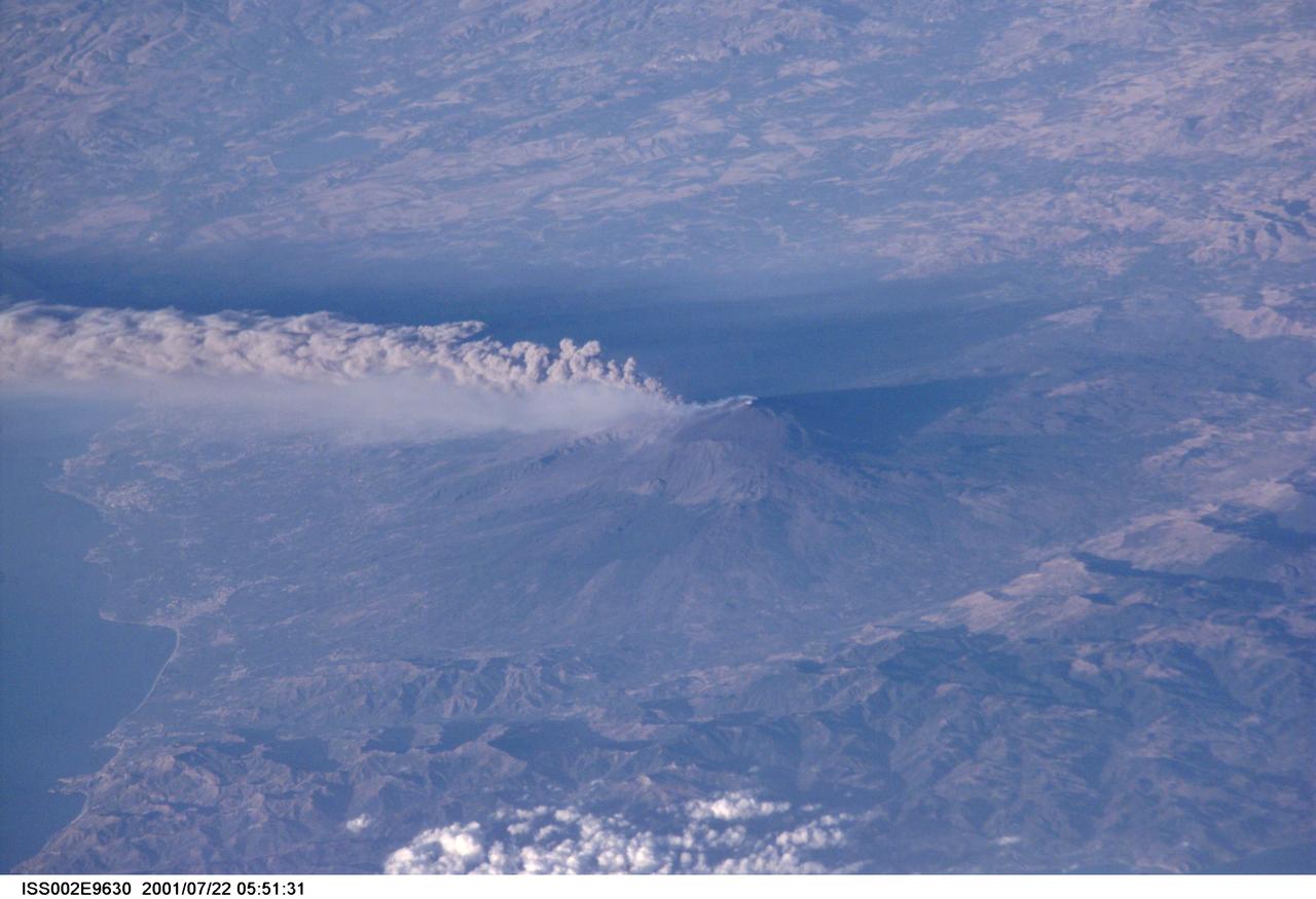
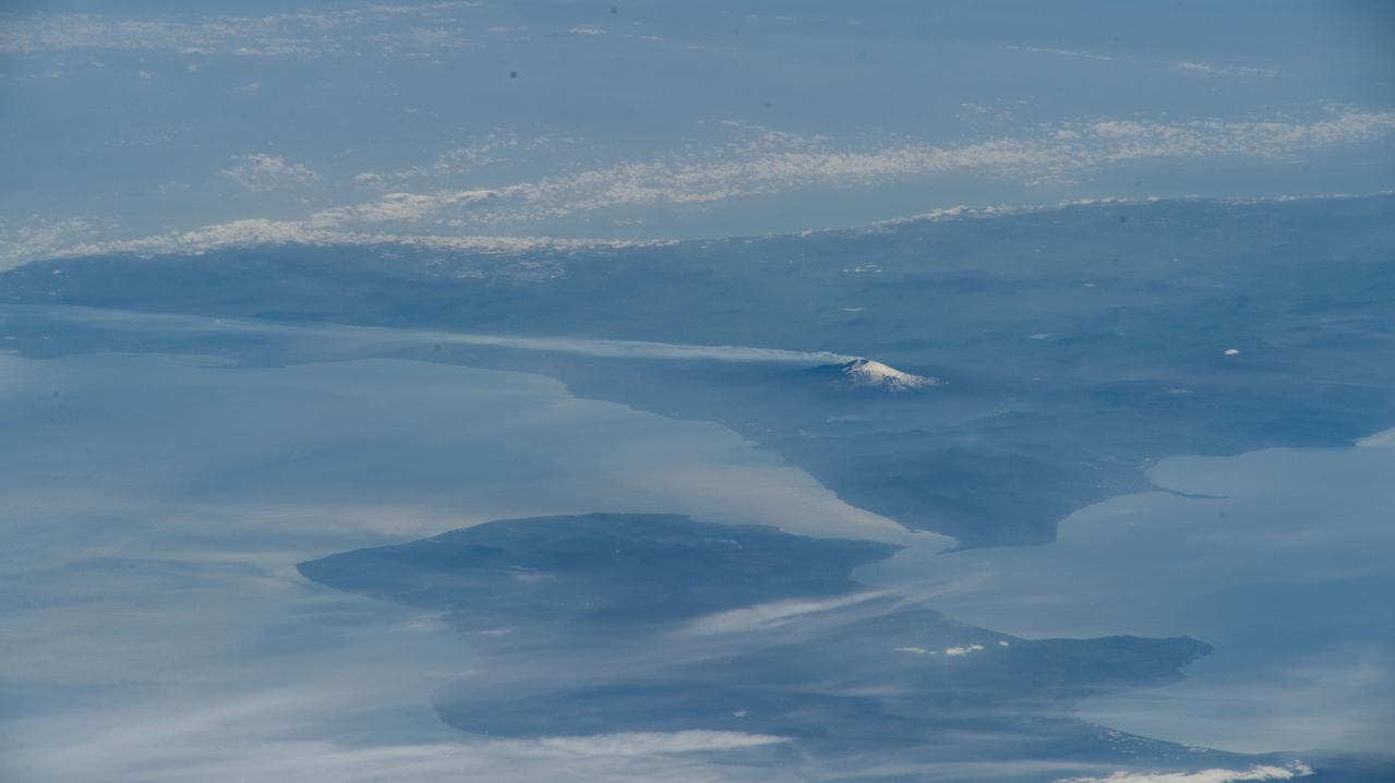
ISS002-E-9630 (22 July 2001) --- The active volcano Mt. Etna on the island of Sicily was recorded by an Expedition Two crew member with a digital still camera.
iss069e000127 (March 30, 2023) --- Mount Etna, an active stratovolcano on Italy's island of Sicily, billows smoke in this oblique photograph from the International Space Station as it orbited 262 miles above the Black Sea coast of Ukraine.
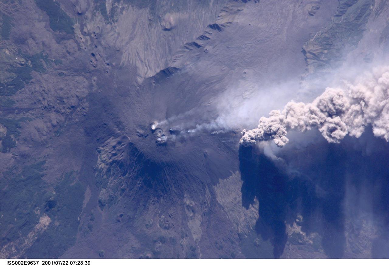
ISS002-E-9637 (22 July 2001) --- An overhead look at the smoke and ash being expelled from the erupting volcano Mt. Etna on the island of Sicily. This image was recorded by an Expedition Two crew member with a digital still camera.
ISS040-E-080962 (26 July 2014) --- One of the Expedition 40 crew members aboard the International Space Station photographed this oblique night image of almost the entire countries of Italy and Sicily on July 26, 2014.
iss067e107088 (June 2, 2022) --- Mount Etna, Europe's tallest active volcano on the coast of Italy's island of Sicily, is pictured billowing with activity as the International Space Station orbited 263 miles above Bulgaria.
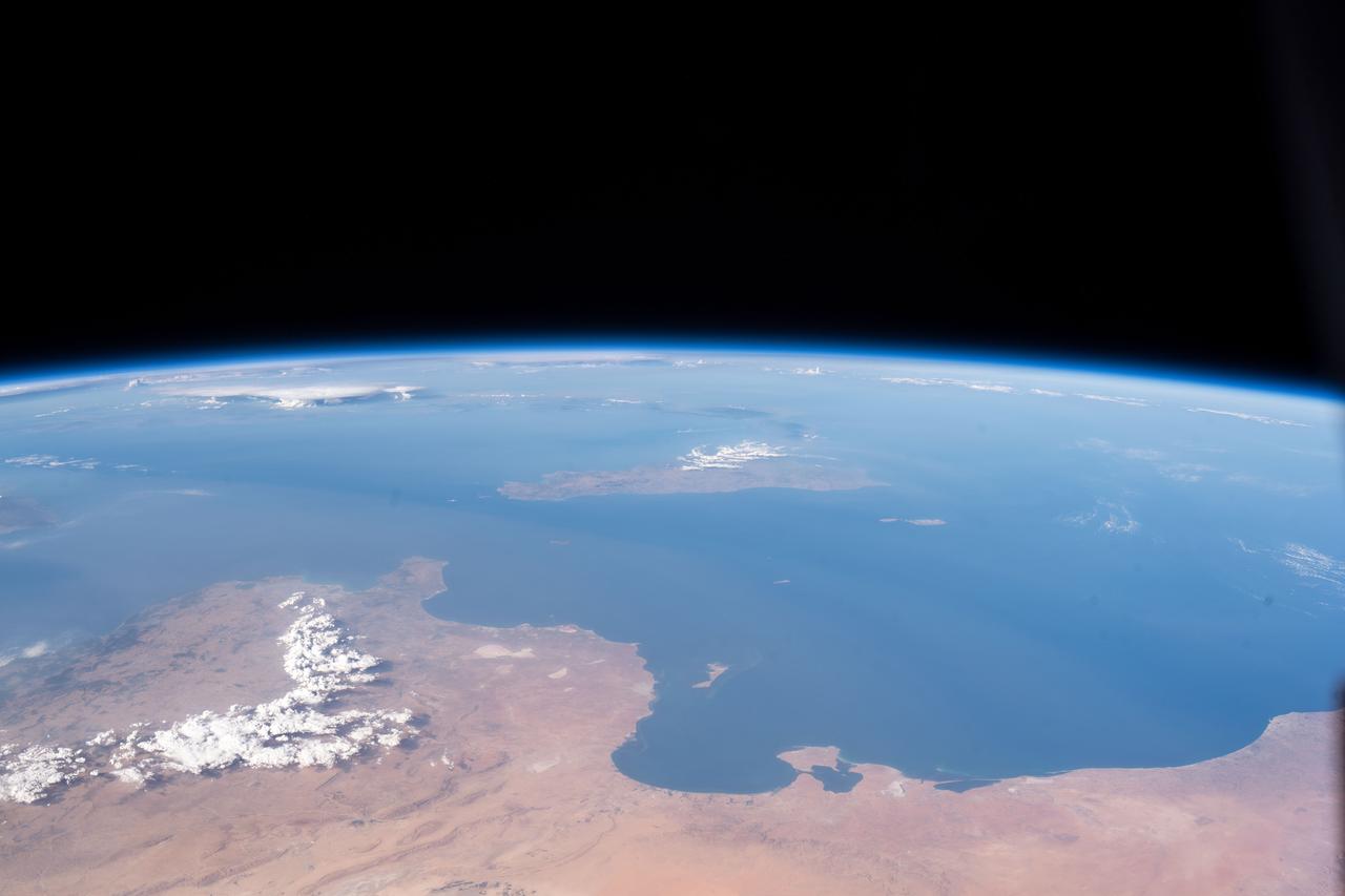
iss060e014848 (July 26, 2019) --- The Mediterranean coasts of Tunisia and Libya and the Italian island of Sicily across the sea are pictured as the International Space Station orbited 260 miles above north Africa.

iss060e019901 (July 29, 2019) --- The International Space Station was orbiting 258 miles above the Mediterranean Sea when an Expedition 60 crewmember photographed a well-lit Italy and its island of Sicily near midnight local time.
iss059e099173 (June 9, 2010) --- The International Space Station was orbiting 255 miles above the Mediterranean Sea when an Expedition 59 crewmember looking northwest took this photograph of Italy and its island Sicily.
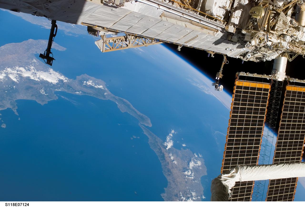
S118-E-07124 (14 Aug. 2007) --- A portion of the International Space Station frames this view of the lower portion of Italy and a portion of Sicily, photographed by a STS-118 crewmember while Space Shuttle Endeavour remains docked with the station.
iss064e029306 (Feb. 3, 2021) --- Mount Etna, an active volcano on the east coast of Sicily, Italy, is pictured from the International Space Station as it orbited 263 miles above. Credit: Roscosmos
iss069e000129 (March 30, 2023) --- Mount Etna, an active stratovolcano on Italy's island of Sicily, billows smoke in this photograph from the International Space Station as it orbited 262 miles above.
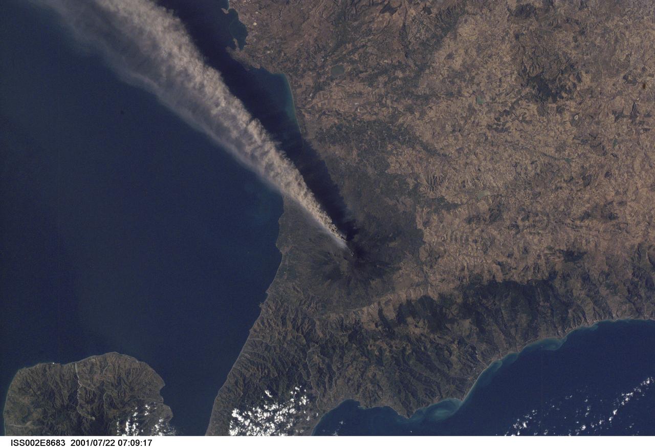
ISS002-E-8683 (22 July 2001) --- Smoke and ash combine to create a plume extending from the erupting volcano on Mt. Etna in Sicily. The digital still image was recorded by one of the Expedition Two crew members.
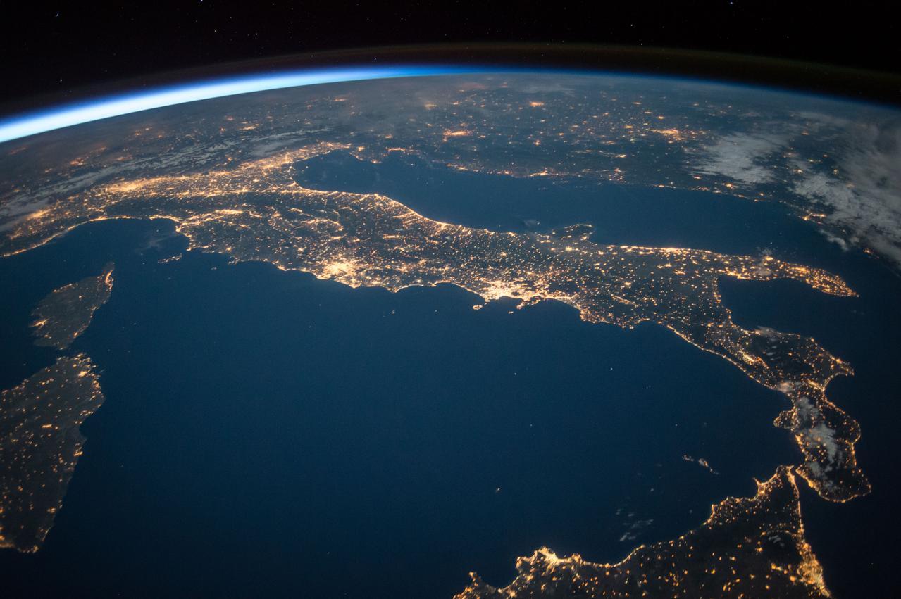
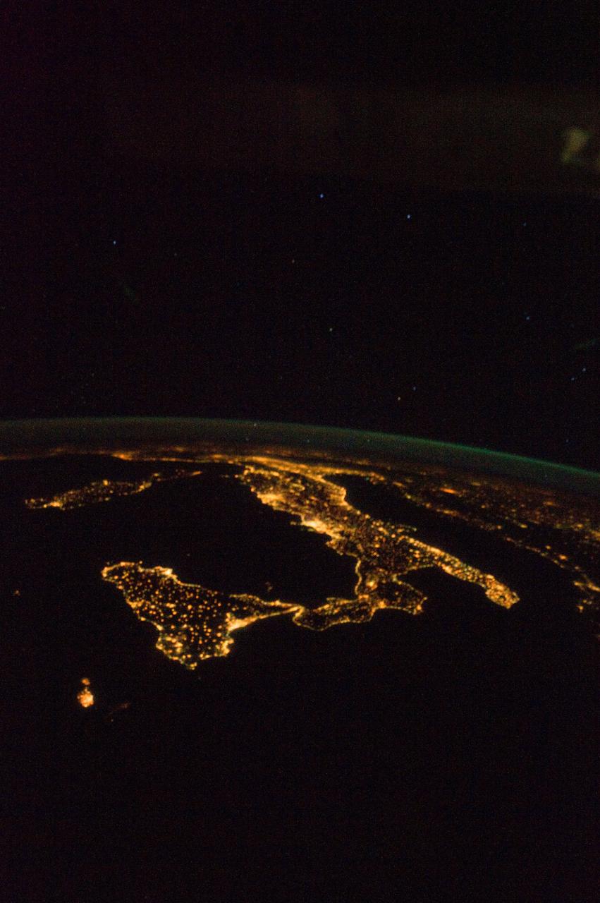
ISS047e125942 (05/21/2016) --- The familiar "boot" shape of the county of Italy stands out in this nighttime image with sparkling city lights reaching from Sicily off the "toe" of the boot, to the approaches to the Alps on the north end of the country.
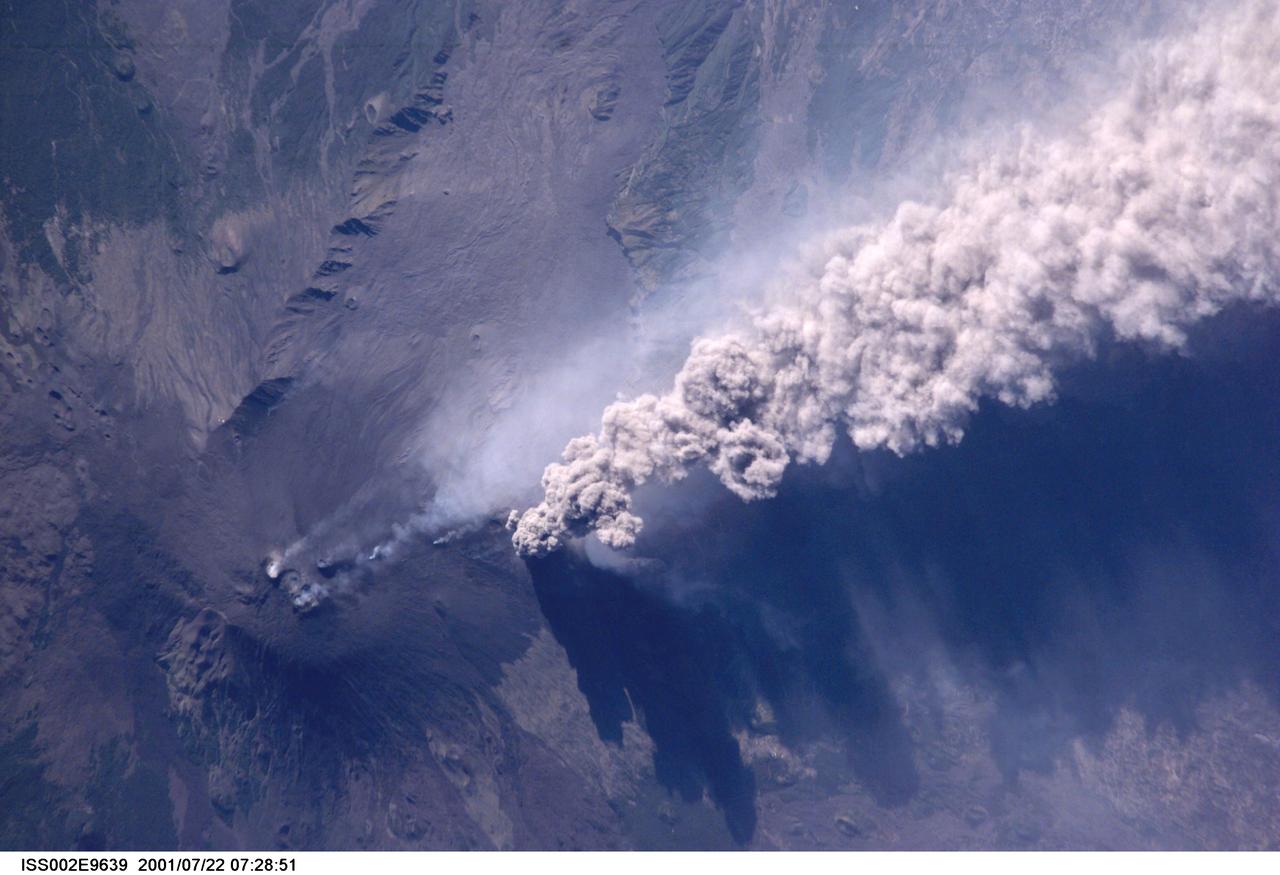
ISS002-E-9639 (22 July 2001) --- An overhead look at the smoke and ash being expelled from the erupting volcano Mt. Etna on the island of Sicily. This image was recorded by an Expedition Two crew member with a digital still camera.
ISS036-E-025908 (29 July 2013) --- One of the Expedition 36 crew members aboard the Earth-orbiting International Space Station, as it was passing over Africa, took this night picture of Sicily (center frame) and much of Italy (frame left to frame center) on July 29, 2013. The Stretto de Messina, which separates Sicily from Italy, is near frame center. The high oblique 50mm lens shot includes a scenic horizon with a number of stars in the late July sky. Barely visible in the darkness, part of the long arm of the Space Station Remote Manipulator System or Canadarm2 runs diagonally through the right one-third of the image.
STS078-751-012 (20 June-7 July 1996) --- The international crew of the Life and Microgravity Spacelab (LMS-1) mission onboard the Space Shuttle Columbia photographed this oblique view of the "toe" of Italy and the island of Sicily. Southern Italy is known as the Mezzogiorno because of the intensity of sunshine there at midday (Mezzogiorno is the Italian term for "midday" or "noon"). Mezzogiorno is a mainland subregion consisting of the modern southern Italian regions of Abruzzi, Molise, Campania, Puglia, Basilicata, and Calabria and an insular subregion composed of Sicily and Sardinia. Southern Italy is dominated by the Apennine Range, seen in the photo on the west side, and up to one-half of the land is too steep for any form of cultivation. Coastal plains are generally narrow and poorly drained and are limited to the environs of the cities of Naples and Salerno, Foggia, and Taranto. Chief crops in this region include wheat, olives, grapes, peaches, apricots, pears, and various vegetables. Iron, steel, machine tools, agricultural machinery, and petrochemicals are produced in the industrial triangle of Bari, Brindisi, and Taranto; industries around Naples are more diversified and produce textiles and various consumer goods, iron, steel, Olivetti office machinery, Pirelli cables, Alfa Romeo automobiles, and ships. The Adriatic Sea on the east separates it from the Balkans, and the Mediterranean Sea on the south separates it from North Africa. Three major tectonic plates, converging from the south, the west, and the northeast, create geologically unstable conditions throughout southern Italy and Sicily. The most famous of southern Italy's four active volcanoes is Mount Vesuvius, whose eruption in AD 79 destroyed Pompeii. Sicily's Mount Etna and Stromboli, on an island north of Sicily, were active during this Space Shuttle mission.
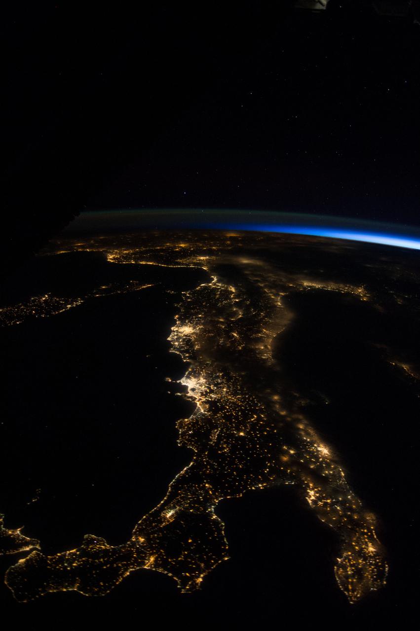
ISS041-E-045376 (27 Sept. 2014) --- One of the Expedition 41 crew members aboard the International Space Station, flying 221 nautical miles above Earth, recorded this night view over southern Italy on Sept. 27, 2014. South is at the bottom of the picture. Italy's "boot" (right) and Sicily are featured in the 28mm image.
ISS47e141893 (06/02/2016) --- This Earth observation image of the southern Mediterranean area was taken by the crew of Expedition 47 aboard the International Space Station. The image looks from the coastline of Greece (bottom left) across the Ionian sea to the bottom "heel" of Italy. The tip of the toe reaches toward Sicily.
STS113-332-030 (14 December 2002) --- The STS-113 crewmembers used a 35mm still camera to record this image of Mt. Etna Volcano erupting on the island of Sicily. The south-looking oblique sunset view shows snowy, winter-time Mt. Etna with a brown smutty ash plume.
ISS040-E-080980 (26 July 2014) --- One of the Expedition 40 crew members aboard the International Space Station photographed this oblique night image of almost the entire country of Italy on July 26, 2014. A small part of Sicily is in the lower left corner.
iss073e0429432 (Aug. 10, 2025) --- Europe's tallest and most active volcano, Mount Etna located on the Italian island of Sicily in the Mediterranean Sea, is pictured from the International Space Station as it orbited 261 miles above the Tyrrhenian Sea. Credit: Roscosmos
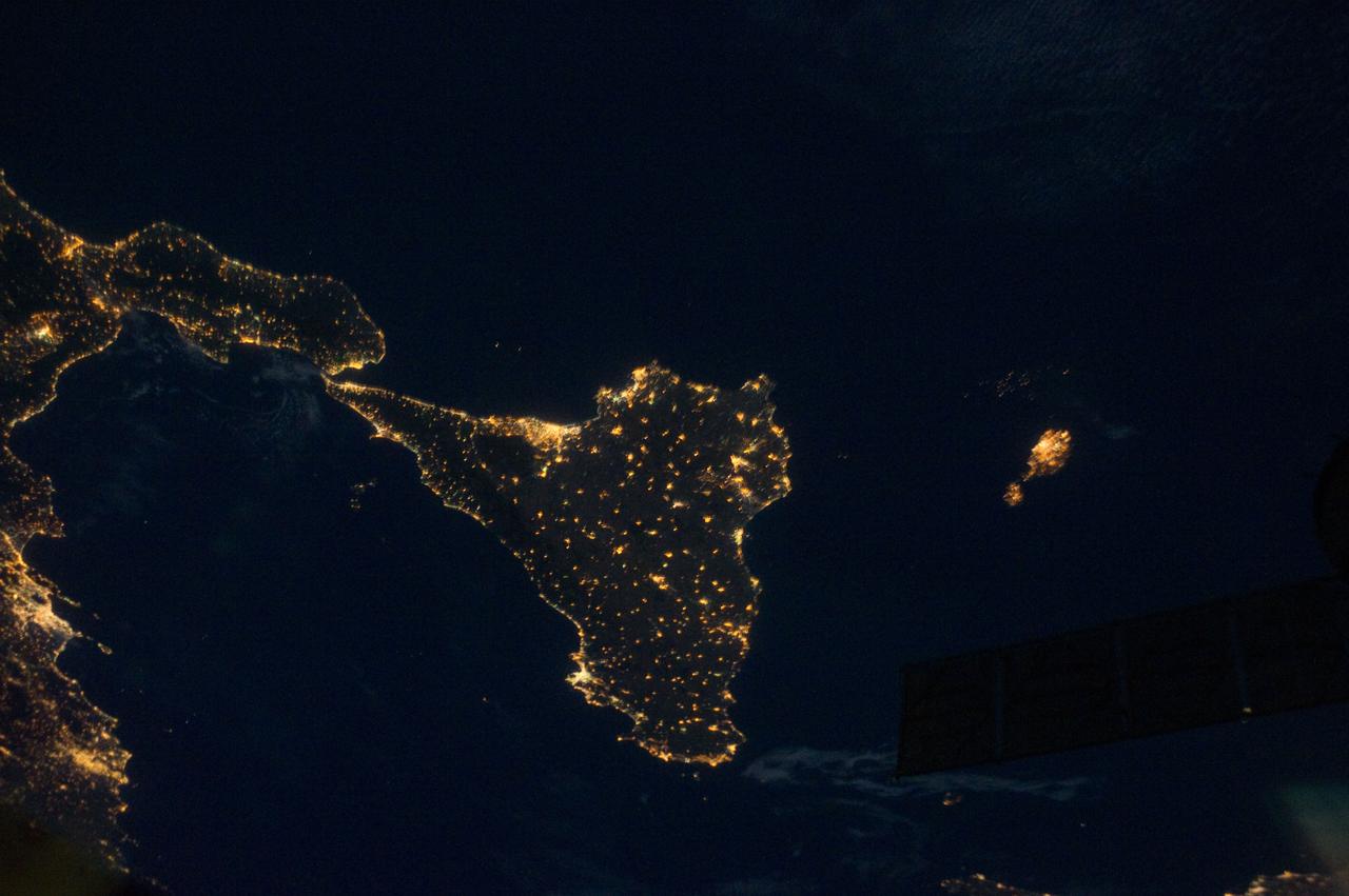
ISS028-E-033104 (18 Aug. 2011) --- Sicily is featured in this night time image captured by one of the Expedition 28 crew members aboard the International Space Station, approximately 220 miles above Earth. The land mass at left edge is part of the "toe" of Italy's "boot." A 38-mm lens was used to record the image.
ISS040-E-131380 (8 Sept. 2014) --- Collections of clouds hug Sicily (lower left) and Italy, which runs vertically through the center of this oblique scene, exposed by one the Expedition 40 crew members aboard the International Space Station at an altitude of 221 nautical miles.
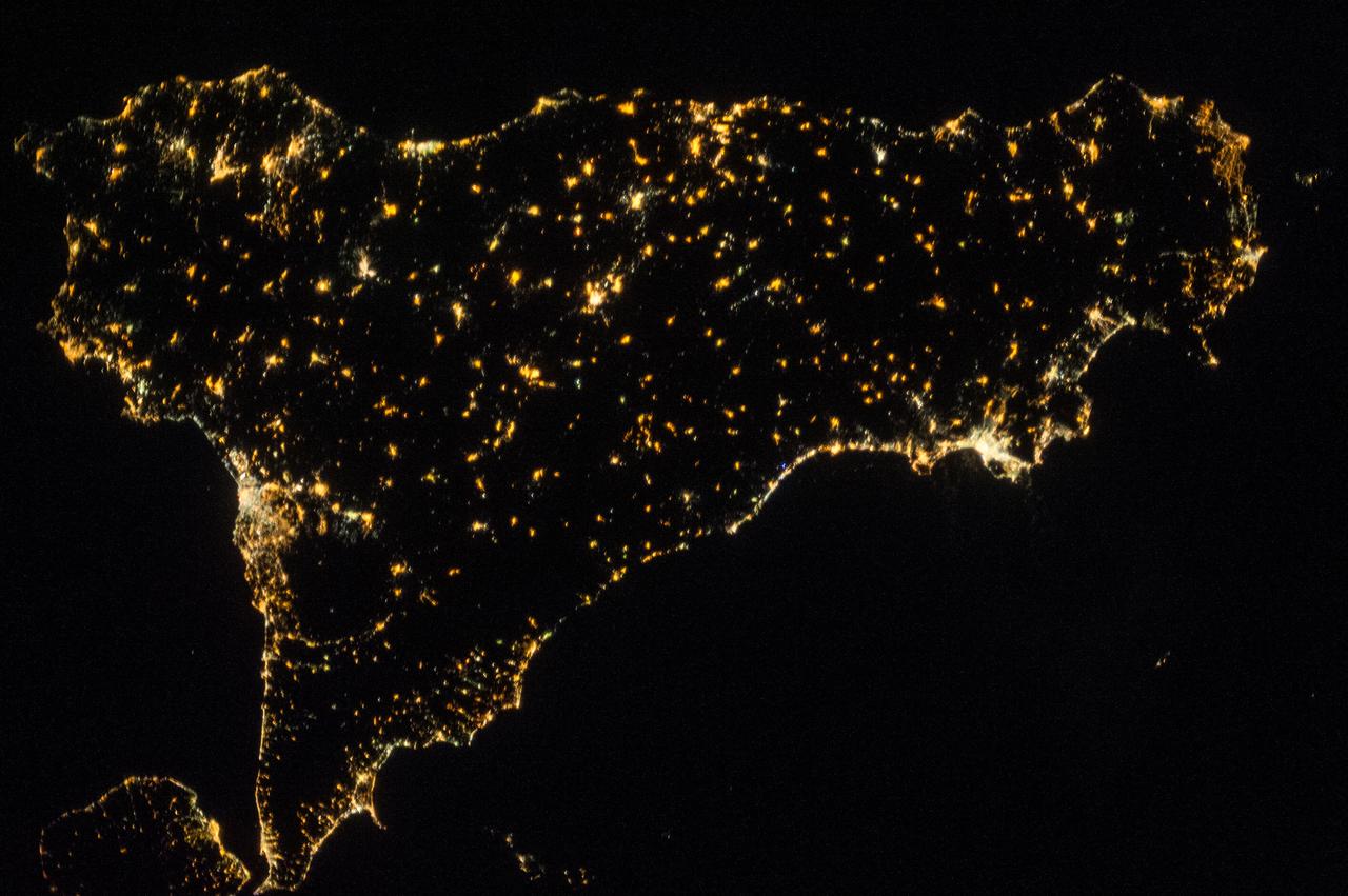
ISS040-E-087275 (1 Aug. 2014) --- Much of the Italian island/province of Sicily is visible in this nighttime nadir image photographed from 221 nautical miles above Earth by one of the Expedition 40 crew members aboard the International Space Station. The tip of the "toe" of Italy's "boot" is barely visible in the upper right corner.
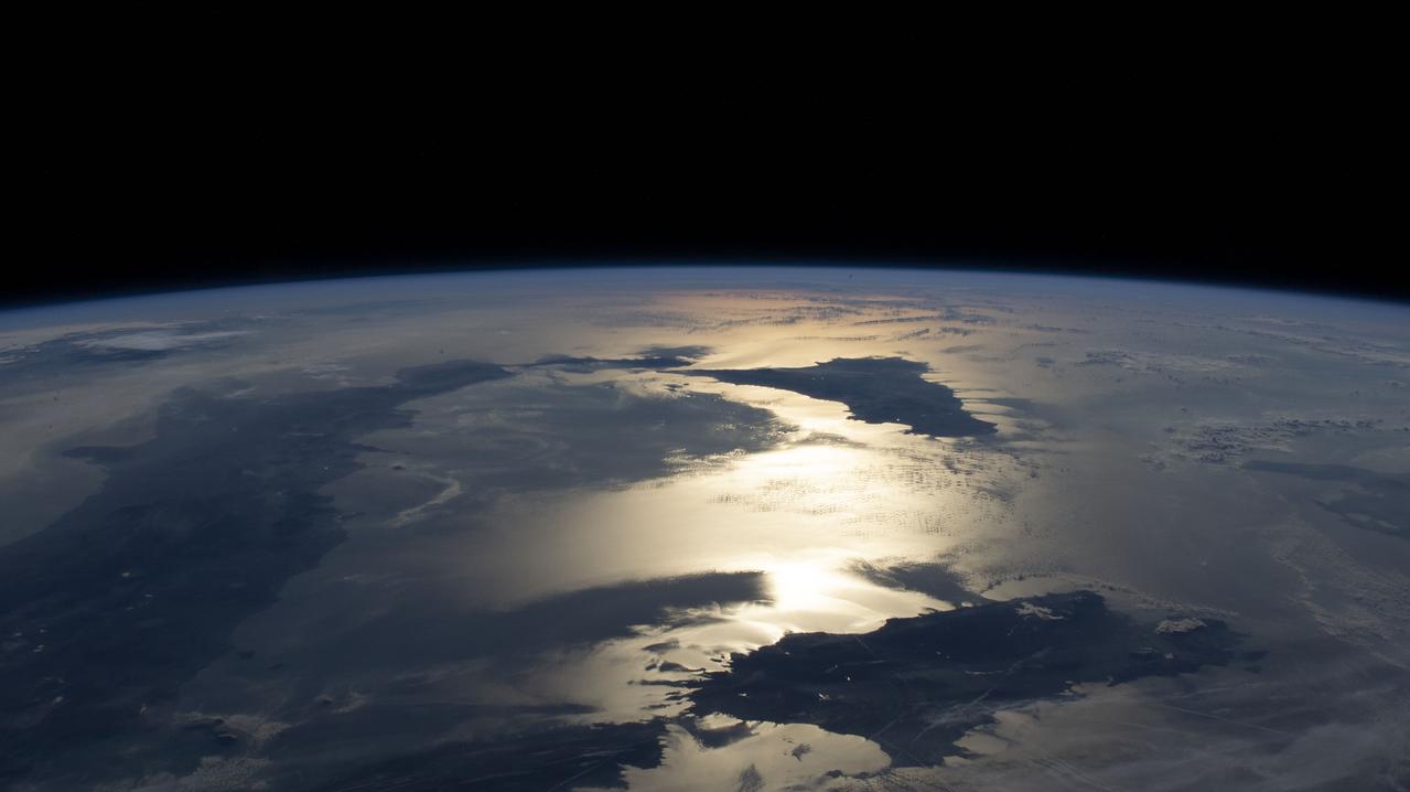
iss059e006521 (March 31, 209) --- The International Space Station orbits 256 miles above the Aegean Sea. This view looks from east to west, from Greece to the boot of Italy and the island of Sicily. The sun's glint radiates off the Ionian Sea in between the two nations.
iss068e020171 (Oct. 31, 2022) --- The International Space Station was orbiting over France when an external high definition camera captured this view looking southward of the sun's glint beaming off the Tyrrhenian Sea surrounded (clockwise from left) by the coast of Italy, the Italian islands of Sicily and Sardinia, and the French island of Corsica.

ISS040-E-092470 (13 Aug. 2014) --- One of the Expedition 40 crew members aboard the International Space Station, flying 225 nautical miles above Earth, recorded this image over southern Italy on Aug. 13, 2014. South is on the left side of the picture. Italy's "boot" and Sicily are featured in the 28mm image.
ISS040-E-090718 (9 Aug. 2014) --- One of the Expedition 40 crew members aboard the International Space Station, flying 225 nautical miles above Earth, recorded this night view over southern Italy on Aug. 9, 2014. South is at the top of the picture. Italy's "boot" and Sicily are featured in the 28mm image.

iss073e0698372 (Sept. 13, 2025) --- The boot of Italy, with the island of Sicily at its "toe," glitters in contrast to the surrounding dark blue seas of southern Europe. The International Space Station was orbiting 262 miles above the Mediterranean Sea when this photograph was taken at approximately 1:43 a.m. local time.
ISS040-E-080967 (26 July 2014) --- One of the Expedition 40 crew members aboard the International Space Station photographed this oblique night image of almost the entire country of Italy and the islands of Sicily, Corse and Sardinia on July 26, 2014.
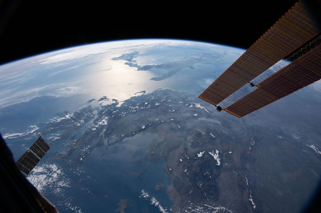
iss067e176401 (July 4, 2022) --- The city lights of Italy, including the French island of Corse and Italian islands of Sardinia and Sicily, are pictured from the International Space Station from 261 miles above the Mediterranean Sea while flying into an orbital sunrise. In the top foreground, is a portion of the Candarm2 robotic arm.
ISS036-E-025991 (29 July 2013) --- One of the Expedition 36 crew members aboard the Earth-orbiting International Space Station took this night picture of Sicily (top) and the tip of Italy's "boot" in the Mediterranean Sea on July 29, 2013.
ISS040-E-087282 (1 Aug. 2014) --- The Italian island/province of Sicily is almost totally visible in this nighttime nadir image photographed from 221 nautical miles above Earth by one of the Expedition 40 crew members aboard the International Space Station. The "toe" of Italy's "boot" is in the upper left corner.
ISS036-E-025984 (29 July 2013) --- One of the Expedition 36 crew members aboard the Earth-orbiting International Space Station took this night picture of Sicily in the Mediterranean Sea on July 29, 2013. The Stretto de Messina is just out of frame at bottom left.
On Sunday, November 3, 2002, Mt. Etna's ash-laden plume was imaged by the Advanced Spaceborne Thermal Emission and Reflection Radiometer (ASTER) on NASA's Terra satellite. The plume is seen blowing toward the south-southeast, over the city and airport of Catania, Sicily. The previous day, the plume was blowing toward the northwest, and posed no hazard to Catania. The current eruption of Mt. Etna, Europe's most active volcano, began on October 27. These sorts of observations from space may help civil defense authorities mitigate hazards from active eruptions. Space data may also help scientists evaluate the behavior and effects volcanic eruptions have on our global climate system. http://photojournal.jpl.nasa.gov/catalog/PIA03881

STS113-332-035 (14 December 2002) --- The STS-113 crewmembers used a 35mm still camera to record this image of Mt. Etna Volcano erupting on the island of Sicily. The oblique, south-looking view shows Mt. Etna's dark ash plume rising above the general altitude of storm clouds over the Mediterranean Sea at sunset on Dec. 14, 2002.

S135-E-006268 (9 July 2011) --- A nadir view from the Earth-orbiting space shuttle Atlantis, photographed by one of four STS-135 crewmembers, shows the area of Italy referred to as the "boot." Part of Sicily is at frame's bottom center. The astronauts were on the mission's second day of activity in Earth orbit, and the eve of docking day with the International Space Station. Photo credit: NASA
iss072e000922 (Sept. 23, 2024) -- The vibrant night lights of coastal cities on the Mediterranean Sea, from Spain to Italy in Europe and Algeria to Lybia in Africa, are pictured from the International Space Station as it orbited 262 miles above Barcelona. Peeking in at the bottom of the image is Mallorca Island, next to it Minorca. The Italian islands of Corsica, Sardinia, and Sicily are also visible. Above Earth, stars glitter in the night sky.
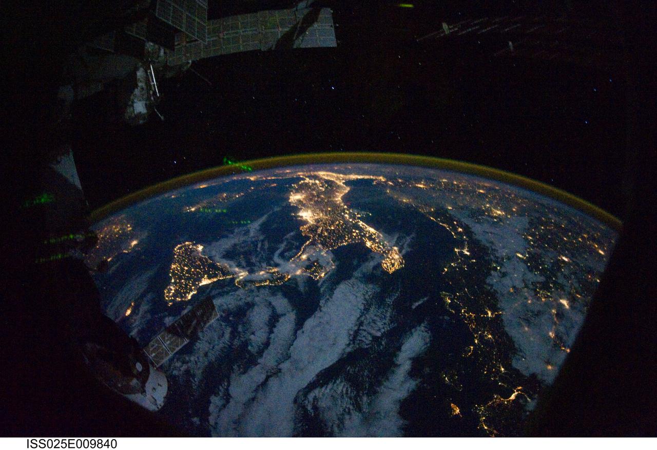
ISS025-E-009840 (28 Oct. 2010) --- Parts of Europe and Africa are very easily recognizable in this night time image shot by one of the Expedition 25 crew members aboard the International Space Station flying 220 miles above Earth on Oct. 28. The view "looks" northward over Sicily and the "boot" of Italy, with the Mediterranean Sea representing most of the visible water in the view and the Adriatic Sea to the right of center. Tunisia is partially visible at left. Part of a docked Russian spacecraft and other components of the ISS are in the foreground.
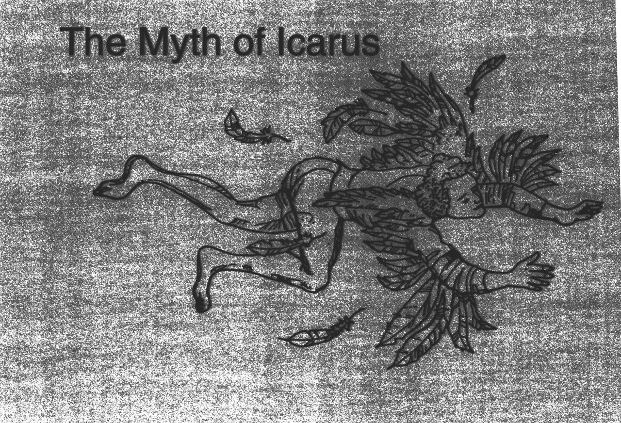
Ever since humans first saw birds soar through the sky, they have wanted to fly. The ancient Greeks and Romans pictured many of their gods with winged feet, and imagined mythological winged animals. According to the legend of Daedalus and Icarus, the father and son escaped prison by attaching wings made of wax and feathers to their bodies. Unfortunately, Icarus flew too near the sun, and the heat caused the wax and feathers to melt. The feathers fell off, and Icarus plummeted to the sea. Daedalus landed safely in Sicily.
An Expedition Two crewmember aboard the International Space Station (ISS) captured this overhead look at the smoke and ash regurgitated from the erupting volcano Mt. Etna on the island of Sicily, Italy. At an elevation of 10,990 feet (3,350 m), the summit of the Mt. Etna volcano, one of the most active and most studied volcanoes in the world, has been active for a half-million years and has erupted hundreds of times in recorded history.
ISS043182340 (05/08/2015) --- NASA astronaut Scott Kelly took this intriguing picture of Mount Etna, a volcano on the Italian island of Sicily. Located on the northeast part of the island it first erupted 500,000 years ago and is still active today. Scott tweeded this image from the International Space Station with the comment: "MtEtna Highest European active #volcano lives up to its Italian name Mongibello (beautiful mountain) from space too".
ISS028-E-033099 (18 Aug. 2011) --- Sicily is featured in this night time image captured by one of the Expedition 28 crew members aboard the International Space Station, approximately 220 miles above Earth. The land mass in upper right corner is part of the "toe" of Italy's "boot." A 32-mm focal length was used to record the image.
STS084-714-007 (15-24 May 1997) --- This 70mm image of the island of Corsica was photographed from the Space Shuttle Atlantis during the STS-84 mission. Birthplace of Napoleon Bonaparte, Corsica is the fourth largest island (after Sicily, Sardinia, and Cyprus) in the Mediterranean. Two-thirds of the island is mountainous with the majority of the population (1990-249, 737) living on the east coast (the "handle on the island points north). French is the official language.
ISS037-E-018864 (23 Oct. 2013) --- This night image of most of Italy and all of Sicily was photographed by one of the Expedition 37 crew members aboard the International Space Station flying approximately 240 miles above Earth on Oct. 23, 2013. The night lights of Rome and Naples are visible near the center of the frame. Many other major cities are also visible by their lights. The Adriatic Sea is on the east (right) side of Italy.
STS098-713-011 (15 February 2001) --- An oblique, westerly-looking view over the Strait of Messini (center), which runs between Italy's "foot" part of the so-called "boot" (bottom) and the heavily cloud-covered Sicily (top). The image was recorded with a handheld 70mm camera by one of the STS-98 crew members aboard the Earth-orbiting Space Shuttle Atlantis. Parts of the Tyrrhenian Sea (right center), Ionian Sea (lower right) and the Mediterranean Sea (left) are covered in the picture.
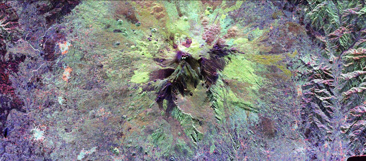
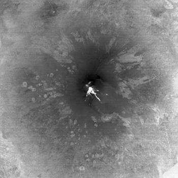
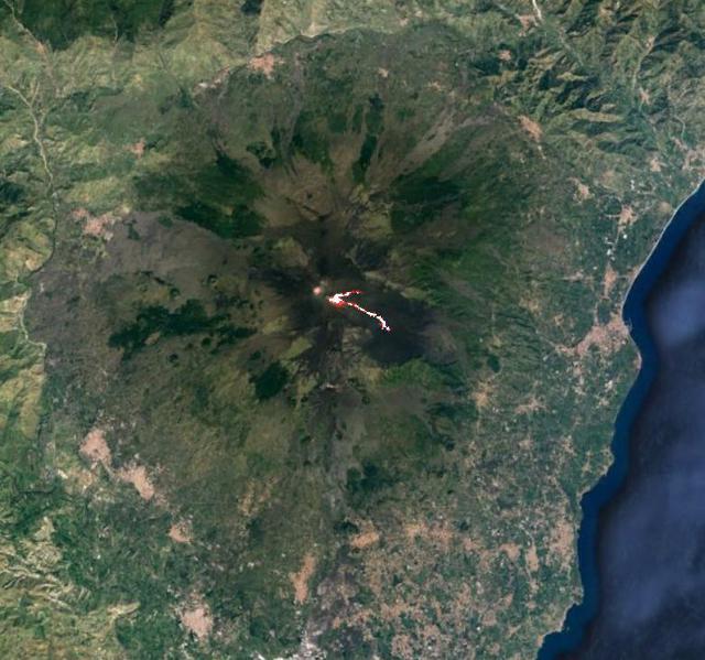
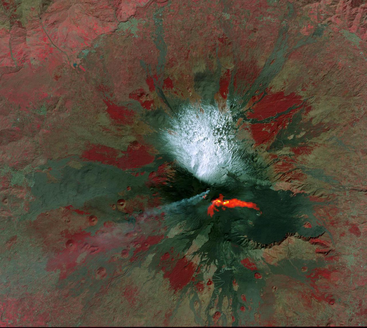
The summit of the Mount Etna volcano on the island of Sicily, Italy, one of the most active volcanoes in the world, is shown near the center of this radar image. Lava flows of different ages and surface roughness appear in shades of purple, green, yellow and pink surrounding the four small craters at the summit. Etna is one of the best-studied volcanoes in the world and scientists are using this radar image to identify and distinguish a variety of volcanic features. Etna has erupted hundreds of times in recorded history, with the most recent significant eruption in 1991-1993. Scientists are studying Etna as part of the international "Decade Volcanoes" project, because of its high level of activity and potential threat to local populations. This image was acquired on October 11, 1994 by the Spaceborne Imaging Radar-C/X-Band Synthetic Aperture Radar (SIR-C/X-SAR) aboard the space shuttle Endeavour. SIR-C/X-SAR, a joint mission of the German, Italian and the United States space agencies, is part of NASA's Mission to Planet Earth. The image is centered at 37.8 degrees North latitude and 15.1 degrees East longitude and covers an area of 51.2 kilometers by 22.6 kilometers (31.7 miles by 14.0 miles). http://photojournal.jpl.nasa.gov/catalog/PIA01776
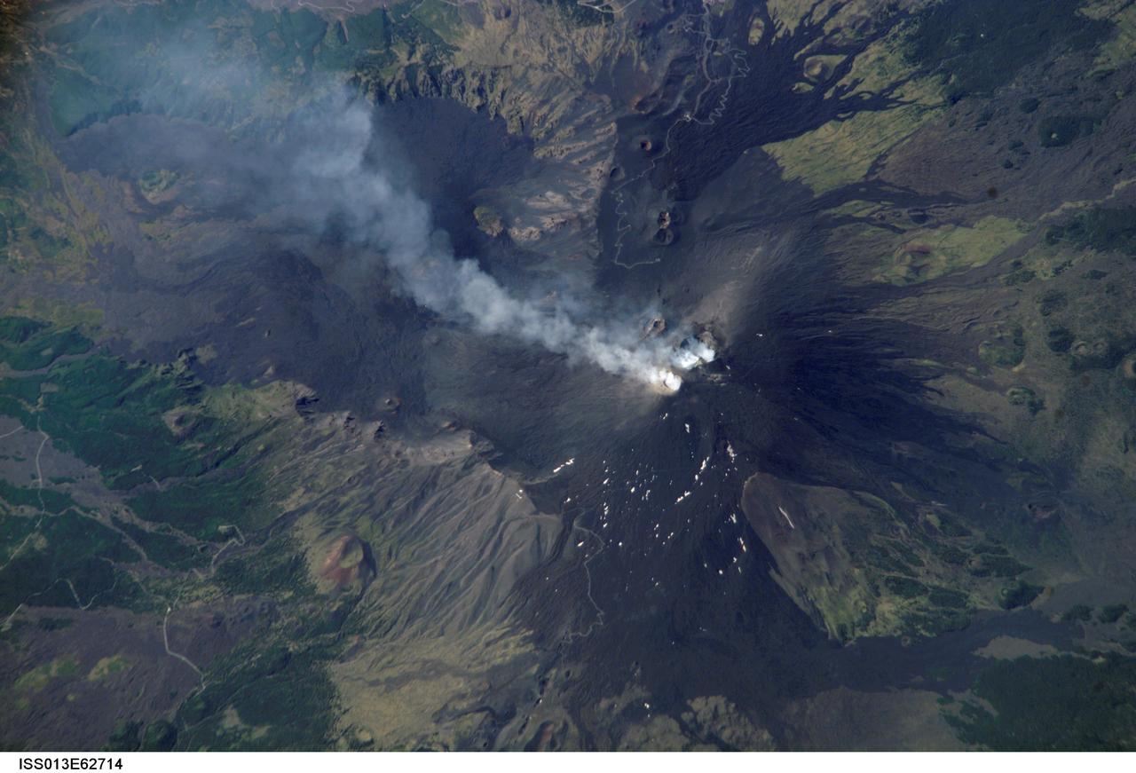
ISS013-E-62714 (2 Aug. 2006) --- Mt. Etna Summit Plumes, Sicily is featured in this image photographed by an Expedition 13 crewmember on the International Space Station. One of the most consistently active volcanoes in the world is Sicily's Mt. Etna, which has a historical record of eruptions dating back to 1500 B.C. This image captures plumes of steam and possible minor ash originating from summit craters on the mountain -- the Northeast Crater and Central Crater, which includes two secondary craters (Voragine and Bocca Nuova). Explosions were heard from the rim of the Northeast Crater on July 26, and scientists suspect that these plumes are a continuation of that activity. The massive 3350 meter high volcano is located approximately 24 kilometers to the north of Catania, the second largest city in Sicily, and dominates the northern skyline. Much of Etna's surface is comprised of numerous generations of dark basaltic lava flows, as can be seen extended outwards from the summit craters. Fertile soils developed on older flows are marked by green vegetation. While the current explosive eruptions of Etna tend to occur at the summit, lava flows generally erupt through fissures lower down on the flanks of the volcano. Many of the lava flow vents are marked by cinder cones on the flanks of Mt. Etna. Scientists have noted evidence of larger eruptive events as well. The Valle Del Bove to the south-southeast of the summit is a caldera formed by the emptying of a subsurface magma chamber during a large eruptive event -- once the magma chamber was emptied, the overlaying roof material collapsed downwards.
ISS028-E-008604 (11 June 2011) --- A night view of the southern Italian Peninsula is featured in this image photographed by an Expedition 28 crew member on the International Space Station. The Earth’s surface at night is covered with a delicate tracery of lights, particularly in regions – such as Europe – that have a long history of urban development. Large urban areas are recognizable from orbit due to extensive electric lighting and distinct street patterns; with smaller urban areas spread across the land surface and coastlines, the outlines of continental landmasses are easily discernable at night. This photograph highlights the night time appearance of the southern Italian Peninsula; the toe and heel of Italy’s “boot” are clearly defined by the lights of large cities such as Naples, Bari, and Brindisi as well as numerous smaller urban areas. The bordering Adriatic, Tyrrhenian, and Ionian Seas appear as dark regions to the east, west, and south of the boot. The city lights of Palermo and Catania on the island of Sicily are visible at image bottom center. The space station was located over an area of Romania close to the capital city of Bucharest – approximately 945 kilometers to the northeast—at the time this image was taken. Part of a docked Russian spacecraft solar panel array is visible in the foreground at left. The distance between the image subject area and the position of the photographer, as well as the viewing angle looking outwards from the space station, contributes to the distorted appearance of the Italian Peninsula and Sicily in the image.
ISS040-E-081344 (26 July 2014) --- Orbital Sciences' Cygnus cargo carrier craft, in the grasp of the International Space Station's robot arm, is prominent in the foreground of this nighttime photo, taken by one of the Expedition 40 crew members aboard the orbital outpost, flying at an altitude of 225 nautical miles. Many European countries can be seen in the photo. Nearly all of Italy, from Turin (bottom left) to the island of Sicily (right center), is visible, as are the islands of Corsica and Sardinia in the Mediterranean in the center foreground. Looking across Italy over the Adriatic Sea, city lights in several other countries are visible. The 1/6 shutter speed allows for a large number of stars to be visible above the horizon.

ISS030-E-074752 (25 Jan. 2012 ) --- This nighttime panorama of much of Europe was photographed by one of the Expedition 30 crew members aboard the International Space Station flying approximately 240 miles above the Tyrrhenian Sea on Jan. 25, 2012. Most of the country of Italy is visible running horizontally across the center of the frame, with the night lights of Rome and Naples being visible to the center and right center, respectively. Sardinia, and Corsica are in the lower left quadrant of the photo, and Sicily is at lower right corner. The Adriatic Sea is on the other side of Italy, and beyond it to the east and north can be seen parts of several other European nations.
ISS036-E-027014 (31 July 2013) --- One of the Expedition 36 crew members aboard the Earth-orbiting International Space Station, as it was passing over Eastern Europe on July 31, 2013, took this night picture looking toward the Mediterranean Sea, which almost blends into the horizon. Also visible are the Aegean Sea, Adriatic Sea and Mediterranean Sea. Parts of the following countries are among those visible as well: Greece, Italy, Sicily, Bulgaria, Serbia, Croatia and Albania. The high oblique 50mm lens shot includes a number of stars in the late July sky. A solar array panel is visible in the darkness on the right side of the frame.
Mt. Etna, Italy erupted Tuesday, February 16, 2021, sending rivers of lava down the southeast flank of the volcano, and spewing ashes and volcanic stones over nearby villages. Sicily's Catania Airport was temporarily closed due to an ash plume that rose to 3700 m altitude. The ASTER nighttime thermal infrared data shows the extent of the active lava flows, draped over an older Google Earth image. The image was acquired February 17, 2021, covers an area of 38 by 39 km, and is located at 37.8 degrees north, 15 degrees east. https://photojournal.jpl.nasa.gov/catalog/PIA24417
S135-E-006377 (9 July 2011) --- An almost vertical view from the Earth-orbiting space shuttle Atlantis, photographed by one of four STS-135 crewmembers, shows the southernmost part of Italy, referred to as the "boot." The eastern-most part of Sicily made it into the frame at left. The dark triangle in upper left corner is part of the window frame on the shuttle's flight deck. When the photo was taken, the STS-135 astronauts were on the mission's second day of activity in Earth orbit, and the eve of docking day with the International Space Station. Photo credit: NASA
ISS032-E-020159 (18 Aug. 2012 ) --- This oblique, nighttime panorama of much of Europe was photographed by one of the Expedition 32 crew members aboard the International Space Station flying approximately 240 miles above the Mediterranean Sea on Aug. 18, 2012. The country of Italy is visible running diagonally southward from the horizon across the center of the frame, with the night lights of Rome and Naples being visible on the coast near the center. Sardinia and Corsica are just above left center of the photo, and Sicily is at lower left. The Adriatic Sea is on the other side of Italy, and beyond it to the east and north can be seen parts of several other European nations.
Mt. Etna, Italy erupted February 17, 2021, sending rivers of lave down the southeast flank of the volcano, and spewing ashes and volcanic stones over nearby villages. Sicily's Catania Airport was temporarily closed due to an ash plume that rose to 3700 m altitude. By the following week, the eruption had waned. The ASTER visible image shows the extent of the active lava flows (derived from the thermal infrared data). The image was acquired February 26, 2021, covers an area of 25.5 by 27.0 km, and is located at 37.8 degrees north, 15 degrees east. https://photojournal.jpl.nasa.gov/catalog/PIA24418

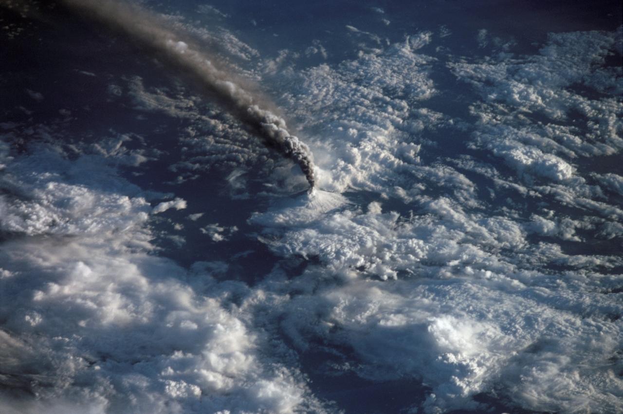
Expedition Five crew members aboard the International Space Station (ISS) captured this overhead look at the smoke and ash regurgitated from the erupting volcano Mt. Etna on the island of Sicily, Italy in October 2002. Triggered by a series of earthquakes on October 27, 2002, this eruption was one of Etna's most vigorous in years. This image shows the ash plume curving out toward the horizon. The lighter-colored plumes down slope and north of the summit seen in this frame are produced by forest fires set by flowing lava. At an elevation of 10,990 feet (3,350 m), the summit of the Mt. Etna volcano, one of the most active and most studied volcanoes in the world, has been active for a half-million years and has erupted hundreds of times in recorded history.
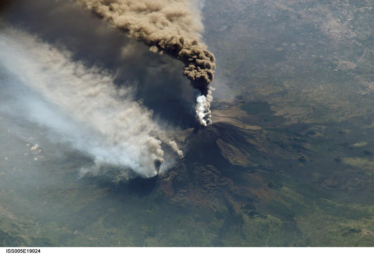
ISS005-E-19024 (30 October 2002) --- The three-member crew of the Expedition Five mission onboard the International Space Station was able to observe Mt. Etna’s spectacular eruption, and photograph the details of the eruption plume and smoke from fires triggered by the lava as it flowed down the 11,000 ft mountain. This image and a second image (ISS005-E-19016) are looking obliquely to the southeast over the island of Sicily. The wider view (ISS005-E-19024) shows the ash plume curving out toward the horizon, caught first by low-level winds blowing to the southeast, and to the south toward Africa at higher altitudes. Ashfall was reported in Libya, more than 350 miles away. The lighter-colored plumes downslope and north of the summit seen in this frame are produced by forest fires set by lava flowing into the pine forests on the slope of the mountain. This image provides a more three-dimensional profile of the eruption plume. This eruption was one of Etna’s most vigorous in years, volcanologists reported this week. The eruption was triggered by a series of earthquakes on October 27, 2002, they said. These images were taken on October 30. Although schools were closed and air traffic was diverted because of the ash, no towns or villages were reported to have been threatened by the lava flow.
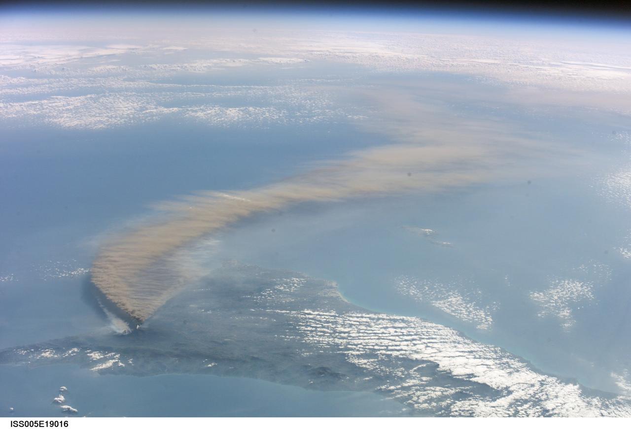
ISS005-E-19016 (30 October 2002) --- The three-member crew of the Expedition Five mission onboard the International Space Station was able to observe Mt. Etna’s spectacular eruption, and photograph the details of the eruption plume and smoke from fires triggered by the lava as it flowed down the 11,000 ft mountain. This image and a second image (ISS005-E-19024) are looking obliquely to the southeast over the island of Sicily. This wide view shows the ash plume curving out toward the horizon, caught first by low-level winds blowing to the southeast, and to the south toward Africa at higher altitudes. Ashfall was reported in Libya, more than 350 miles away. The lighter-colored plumes downslope and north of the summit (see detailed view taken the same day, ISS005-E-19024) are produced by forest fires set by lava flowing into the pine forests on the slope of the mountain. The detailed image provides a more three-dimensional profile of the eruption plume. This eruption was one of Etna’s most vigorous in years, volcanologists reported this week. The eruption was triggered by a series of earthquakes on October 27, 2002, they said. These images were taken on October 30. Although schools were closed and air traffic was diverted because of the ash, no towns or villages were reported to have been threatened by the lava flow.
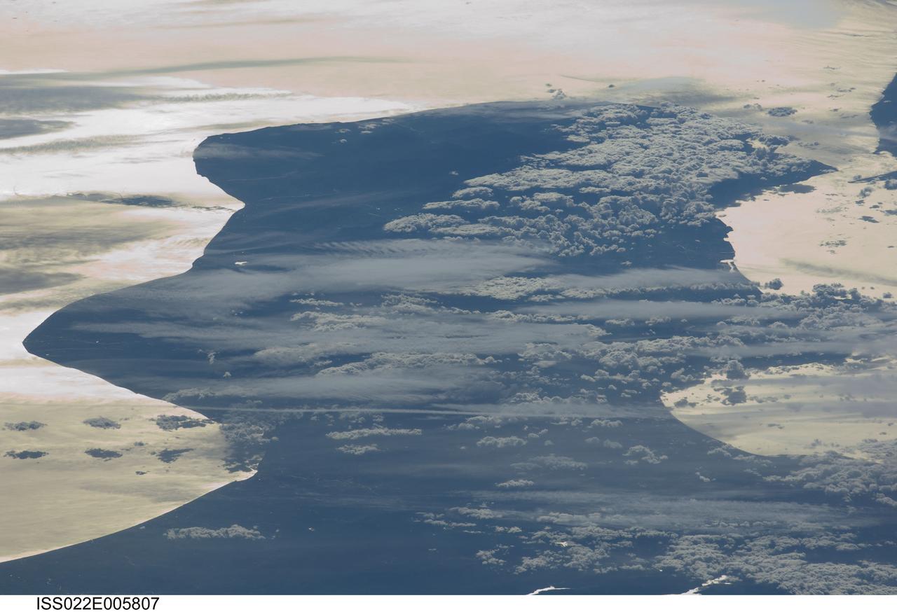
ISS022-E-005807 (3 Dec. 2009) --- Cloud formations and sunglint near Italy are featured in this image photographed by an Expedition 22 crew member on the International Space Station. This view depicts the Calabria region of southern Italy ? the toe of Italy?s ?boot? ? outlined by the Ionian and Tyrrhenian Seas to the southeast and northwest respectively. The water surfaces present a mirror-like appearance due to sunglint. This phenomenon is caused by sunlight reflecting off the water surface directly back towards the crew member aboard the space station. The ISS was located over northwestern Romania, approximately 1,040 kilometers to the northeast of Calabria, when this image was taken. The Calabrian peninsula appears shortened and distorted due to the high viewing angle from the station. Such imagery is termed oblique, indicating that the view is not looking directly downwards towards Earth?s surface from the ISS (known as a nadir view). This highly oblique view also highlights two distinct cloud patterns over the Calabrian interior. Patchy, highly textured cumulus clouds are present at lower altitudes, while grey altostratus clouds are elongated by prevailing winds at higher altitudes. The Strait of Messina, just visible at upper right, marks the boundary between the coastlines of Italy and the island of Sicily.
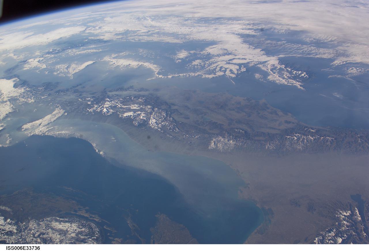
ISS006-E-33736 (25 February 2003) --- The boot of Italy crosses the image in this southwest-looking view taken by an Expedition Six crewmember onboard the International Space Station (ISS). The spine of Italy is highlighted with snow and the largely cloud-covered Mediterranean Sea is at the top. The Adriatic Sea transverses most of the bottom of the image and Sicily appears top left beyond the toe of the boot. The heel lies out of the left side of the image. Corsica and Sardinia appear right of center partly under cloud. The floor of the Po River valley, lower right, is obscured by haze. Experience gained from similar haze events, in which atmospheric pressure, humidity and visibility and atmospheric chemistry were known, suggests that the haze as industrial smog. Industrial haze from the urban region of the central and upper Po valley accumulates to visible concentrations under conditions of high atmospheric pressure and the surrounding mountains prevent easy dispersal. This view illustrates the markedly different color and texture of cloud versus industrial aerosol haze.
STS057-73-075 (21 June-1 July 1993) --- Eastern Mediterranean from an unusually high vantage point over the Nile River, this north-looking view shows not only the eastern Mediterranean but also the entire landmass of Asia Minor, with the Black Sea dimly visible at the horizon. Many of the Greek islands can be seen in the Aegean Sea (top left), off the coast of Asia Minor. Cyprus is visible under atmospheric dust in the northeast corner of the Mediterranean. The dust cloud covers the east end of the Mediterranean, its western edge demarcated by a line that cuts the center of the Nile Delta. This dust cloud originated far to the west, in Algeria, and moved northeast over Sicily, southern Italy, and Greece. Part of the cloud then moved on over the Black Sea, but another part swerved southward back towards Egypt. A gyre of clouds in the southeast corner of the Mediterranean indicates a complementary counterclockwise (cyclonic) circulation of air. The Euphrates River appears as a thin green line (upper right) in the yellow Syrian Desert just south of the blue-green mountains of Turkey. The Dead Sea (lower right) lies in a rift valley which extends north into Turkey and south thousands of miles down the Gulf of Aqaba, the Red Sea, and on through East Africa. The straight international boundary between Israel and Egypt (where the coastline angles) is particularly clear in this view, marked by the thicker vegetation on the Israeli side of the border. The green delta of the Nile River appears in the foreground, with the great conurbation of Cairo seen as a gray area at the apex of the triangle. Most of Egypt's 52 million inhabitants live in the delta. On the east side of the delta, the Suez Canal is visible. On the western corner of the delta lies the ancient city of Alexandria, beside the orange and white salt pans. The World War II battlesite El Alamein lies on the coast.
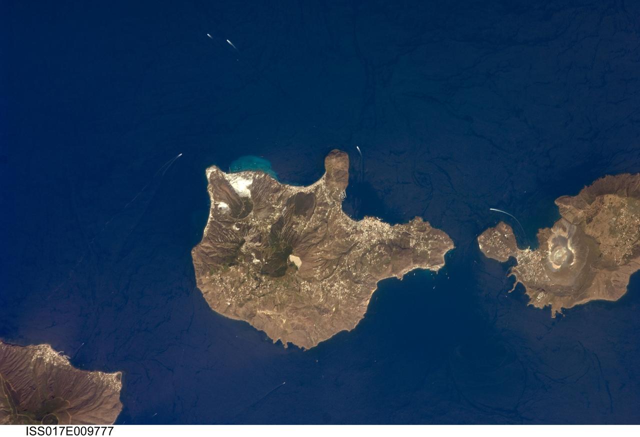
ISS017-E-009777 (24 June 2008) --- Aeolian Islands, Italy are featured in this image photographed by an Expedition 17 crewmember on the International Space Station. The Aeolian Islands formed from a chain of volcanoes in the Tyrrhenian Sea to the north of the island of Sicily. The islands have been studied by geologists and vulcanologists since the 18th century, and were accorded UNESCO World Heritage Site status in 2000 in recognition of their continuing value to study of volcanic processes. Two types of volcanic eruption, Vulcanian and Strombolian, were defined based on study and observation of geologic processes on the islands of Vulcano and Stromboli (not shown). This detailed view features the island of Lipari and the northern portion of the island of Vulcano. Tan, speckled areas on both islands are urban areas and towns. Lipari is the largest of the Aeolian Islands, and is a popular tourist destination due to its rugged volcanic topography and beaches (several boat wakes are visible in the image around the islands). White pumice beaches and caves are located along the northern and northeastern coastlines of Lipari; black sand beaches derived from lava flows can also be found on the island. The most recent eruptive activity on Lipari took place between approximately 580-729. The island of Vulcano (right) is comprised of two calderas -- large craters formed when explosive eruptions empty a magma chamber, followed by collapse of the overlying material into the newly-formed void -- the Caldera della Fossa to the north and the Caldera del Piano to the south. The volcanic cone of La Fossa, located with the Caldera della Fossa, has been the site of much of the historical eruptive activity on the island. The last eruption on Vulcano Island took place during 1898-1900.
Twin volcanic plumes—one of ash, one of gas—rose from Sicily’ Mount Etna on the morning of October 26, 2013. L’Istituto Nazionale di Geofisica e Vulcanologia (INGV) Osservatorio Etneo (National Institute of Geophysics and Volcanology Etna Observatory) reported that Etna was experiencing its first paroxysm in six months. Multiple eruption columns are common at Etna, a result of complex plumbing within the volcano. The Northeast Crater, one of several on Etna’s summit, was emitting the ash column, while the New Southeast Crater was simultaneously venting mostly gas. This natural-color image collected by Landsat 8 shows the view from space at 11:38 a.m. local time. The towering, gas-rich plume cast a dark shadow over the lower, ash-rich plume and Etna’s northwestern flank. Relatively fresh lava flows (less than a century or so old) are dark gray; vegetation is green; and the tile-roofed buildings of Bronte and Biancavilla lend the towns an ochre hue. NASA Earth Observatory image by Jesse Allen and Robert Simmon, using Landsat data from the USGS Earth Explorer. Photograph ©2013, Boris Behncke. Caption by Robert Simmon with contributions from Boris Behncke. Instrument: Landsat 8 - OLI More info: <a href="http://1.usa.gov/1cEcOFi" rel="nofollow">1.usa.gov/1cEcOFi</a> Credit: <b><a href="http://www.earthobservatory.nasa.gov/" rel="nofollow"> NASA Earth Observatory</a></b> <b><a href="http://www.nasa.gov/audience/formedia/features/MP_Photo_Guidelines.html" rel="nofollow">NASA image use policy.</a></b> <b><a href="http://www.nasa.gov/centers/goddard/home/index.html" rel="nofollow">NASA Goddard Space Flight Center</a></b> enables NASA’s mission through four scientific endeavors: Earth Science, Heliophysics, Solar System Exploration, and Astrophysics. Goddard plays a leading role in NASA’s accomplishments by contributing compelling scientific knowledge to advance the Agency’s mission. <b>Follow us on <a href="http://twitter.com/NASA_GoddardPix" rel="nofollow">Twitter</a></b> <b>Like us on <a href="http://www.facebook.com/pages/Greenbelt-MD/NASA-Goddard/395013845897?ref=tsd" rel="nofollow">Facebook</a></b> <b>Find us on <a href="http://instagram.com/nasagoddard?vm=grid" rel="nofollow">Instagram</a></b>
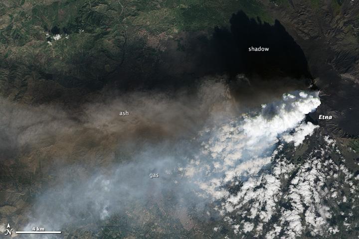
Twin volcanic plumes—one of ash, one of gas—rose from Sicily’ Mount Etna on the morning of October 26, 2013. L’Istituto Nazionale di Geofisica e Vulcanologia (INGV) Osservatorio Etneo (National Institute of Geophysics and Volcanology Etna Observatory) reported that Etna was experiencing its first paroxysm in six months. Multiple eruption columns are common at Etna, a result of complex plumbing within the volcano. The Northeast Crater, one of several on Etna’s summit, was emitting the ash column, while the New Southeast Crater was simultaneously venting mostly gas. This natural-color image collected by Landsat 8 shows the view from space at 11:38 a.m. local time. The towering, gas-rich plume cast a dark shadow over the lower, ash-rich plume and Etna’s northwestern flank. Relatively fresh lava flows (less than a century or so old) are dark gray; vegetation is green; and the tile-roofed buildings of Bronte and Biancavilla lend the towns an ochre hue. NASA Earth Observatory image by Jesse Allen and Robert Simmon, using Landsat data from the USGS Earth Explorer. Photograph ©2013, Boris Behncke. Caption by Robert Simmon with contributions from Boris Behncke. Instrument: Landsat 8 - OLI More info: <a href="http://1.usa.gov/1cEcOFi" rel="nofollow">1.usa.gov/1cEcOFi</a> Credit: <b><a href="http://www.earthobservatory.nasa.gov/" rel="nofollow"> NASA Earth Observatory</a></b> <b><a href="http://www.nasa.gov/audience/formedia/features/MP_Photo_Guidelines.html" rel="nofollow">NASA image use policy.</a></b> <b><a href="http://www.nasa.gov/centers/goddard/home/index.html" rel="nofollow">NASA Goddard Space Flight Center</a></b> enables NASA’s mission through four scientific endeavors: Earth Science, Heliophysics, Solar System Exploration, and Astrophysics. Goddard plays a leading role in NASA’s accomplishments by contributing compelling scientific knowledge to advance the Agency’s mission. <b>Follow us on <a href="http://twitter.com/NASA_GoddardPix" rel="nofollow">Twitter</a></b> <b>Like us on <a href="http://www.facebook.com/pages/Greenbelt-MD/NASA-Goddard/395013845897?ref=tsd" rel="nofollow">Facebook</a></b> <b>Find us on <a href="http://instagram.com/nasagoddard?vm=grid" rel="nofollow">Instagram</a></b>