
SL4-93-167 (February 1974) --- A vertical view of the Kennedy Space Center and the Florida Atlantic coast area is seen in this Skylab 4 Earth Resources Experiments Package S190-B (five-inch earth terrain camera) infrared photography taken from the Skylab space station in Earth orbit. This photograph shows the major land-ocean features of the Florida coast near Vero Beach northward to Cape Canaveral and the KSC complex. The launch pads for the Skylab missions are clearly visible. Identification of living vegetation is possible through the use of the color infrared film. Various shades of red portray differences in the vegetation such as shown in the patterns in the agricultural area near Vero Beach. In the Kennedy Space Center, the nearly continuous and uniform red color shows that most of the land areas are heavily vegetated. The white coastal beach areas are strongly contrasted to the red land and the blue Atlantic Ocean. Old dunal areas in KSC are visible on Merritt Island which is separated from the Launch areas by the Banana River and the mainland by the Indian River. Federal and state highways and numerous causeways over the rivers are easily identified. The Florida mainland is partly shadowed by small white clouds which cast a pronounced shadow to the east of each cloud indicated the Sun is west of solar noon. Federal agencies participating with NASA on the EREP project are the Departments of Agriculture, Commerce, Interior, the Environmental Protection Agency and the Core of Engineers. All EREP photography is available to the public through the Department of Interior's Earth Resources Observations Systems Data Center, Sioux Falls, South Dakota, 57198. Photo credit: NASA
SL4-138-3875 (February 1974) --- A color oblique photograph looking east over the Rocky Mountains and Great Plains. This view covers a portion of the States of Colorado, Wyoming, and Nebraska. A Skylab 4 crewmen took this picture with a hand-held 70mm Hasselblad camera. This entire region, covered with a blanket of snow, depicts much of the structural and topographic features of the Rocky Mountain chain. Man's only apparent change to the snow pattern seen here is the (right center) metropolitan areas of Denver and Colorado Springs, Colorado, which can be observed along the eastern edge of the mountain front. Grand Junction, Colorado on the western slope of the Rocky Mountains is just off the photograph at left center bottom. The major inter-montane valleys of South Park (right center), Middle Park (center), and North Park (left center) are clearly visible and separate the Colorado Rockies Front Range from the high rugged mountains can be discovered such as Pikes Peak near right border (center), Mt. Cunnison region, circular feature accentuated by the Cunnison River (dark) in the right center (bottom) of the photograph. The snow covered peaks of Mts. Harvard, Princeton and Yale form the high region of the Collegiate Range which is the pronounced mountain area in the right center. Snow cover not only enhances mountain features but also the drainage patterns. East of Denver (right corner) the sinuous trace of the South Platte River (center) and its junction with the North Platte River near North Platte, Nebraska. Lake McConaughy in Nebraska is the body of water (black) near the river intersection. The trace of the Republic River in southern Nebraska is visible near the right corner of the photography. Geologic and hydro logic studies using this photograph will be conducted by Dr. Roger Morrison, U.S. Geological Survey. Photo credit: NASA

SL4-93-153 (February 1974) --- A vertical view of the Birmingham and central Alabama area is seen in this Skylab 4 Earth Resources Experiments Package S190-B (five-inch earth terrain camera) infrared photographed taken from the Skylab space station in Earth orbit. Illustrated here is the utility of color infrared film in depicting distribution of living vegetation in the 3,600 square mile Birmingham region. The Birmingham industrial complex, with a population of nearly 850,000, is the light gray area nestled in the valley between the northeast-trending ridges that are prominent topographic features in the southern Appalachian Mountains. The narrow ridges and adjacent valleys reflect folded and faulted sedimentary rocks, indicating the complex geological history of the region. Two major rivers and several reservoirs are easily distinguished in this photograph. Bankhand Lake, formed by a dam on the Black Warrior River, appears as bright blue west of Birmingham. Two lakes are formed by dams on the Goosa River east of Birmingham. Federal and state highways appear as thin white lines and are easily identified. Interstate 65 to Montgomery is the prominent white line extending southward from Birmingham. Power line clearings are visible in the center of the picture along the Goosa River, and can be traced northwestward to northern parts of Birmingham. The predominant deep red color of the picture is due to the reflections from living vegetation. In contrast are the light tan areas that commonly occur as rectangular patterns in the east part of the photograph and represent mature agricultural crops or grazing lands. Analysis of the photographic data from the earth terrain camera will be conducted by Dr. H. Jayroe of the Marshall Space Flight Center in developing analytical techniques. All EREP photography is available to the public through the Department of Interior's Earth Resources Observations Systems Data Center, Sioux Falls, South Dakota, 57198. Photo credit: NASA
SL4-92-300 (February 1974) --- A near vertical view of the Mobile Bay, Alabama area is seen in this Skylab 4 Earth Resources Experiments Package S190-B (five-inch earth terrain camera) photograph taken from the Skylab space station in Earth orbit. North of Mobile the Tombigbee and Alabama Rivers join to form the Mobile River. Detailed configuration of the individual stream channels and boundaries can be defined as the Mobile River flows into Mobile Bay, and thence into the Gulf of Mexico. The Mobile River Valley with its numerous stream channels is a distinct light shade in contrast to the dark green shade of the adjacent areas. The red coloration of Mobile Bay reflects the sediment load carried into the Bay by the rivers. Variations in red color indicate sediment load and the current paths within Mobile Bay. The waterly movement of the along shore currents at the mouth of Mobile Bay is shown by the contrasting light blue of the sediment-laden current and the blue of the Gulf predominately. Agricultural areas east and west of Mobile Bay are characterized by a rectangular pattern in green to white shades. Color variations may reflect the type and growth cycle of crops. Agricultural areas (light gray-greens) are also clearly visible in other parts of the photograph. Interstate 10 extends from near Pascagoula, Mississippi eastward through Mobile to the outskirts of Pensacola, Florida. Analysis of the EREP photographic data will be undertaken by the U.S. Corps of Engineers to determine bay dynamic processes. Federal agencies participating with NASA on the EREP project are the Departments of Agriculture, Commerce, Interior, the Environmental Protection Agency and the Corps of Engineers. All EREP photography is available to the public through the Department of Interior's Earth Resources Observations Systems Data Center, Sioux Falls, South Dakota. 57198 Photo credit: NASA
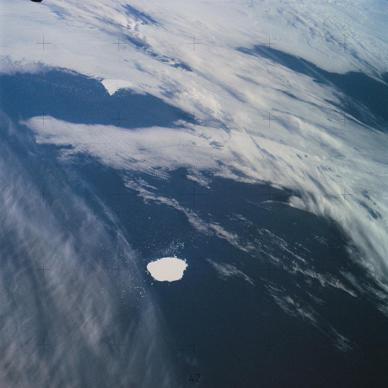
SL4-142-4577 (28 Jan. 1974) --- Two large ice islands in the vicinity of South Georgia Island in the South Atlantic Ocean, as photographed from the Skylab space station in Earth orbit by one of the Skylab 4 crewmen. The camera used was a hand-held 70mm Hasselblad, with SO-368 medium-speed Ektachrome. One of the ice islands is partially obscured by clouds. Ice islands were observed as large as 45 by 60 kilometers (27 x 37 miles) and as far north as 45 degrees south latitude. The size and distribution of the "small" icebergs (to a ship they would look very large) can be used to study the local winds and currents. Recent research has suggested the possibility of towing such Antarctic icebergs to selected areas and using them as water supplies. One such iceberg would contain many times the water as in Lake Powell. Photo credit: NASA
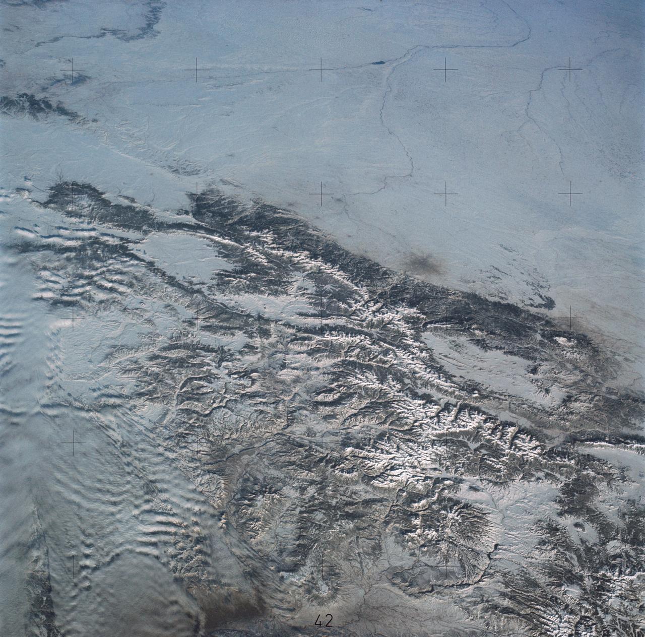
SL4-140-4110 (January 1974) --- View of the USSR, Siberia area from Skylab 4. Other areas seen are Ozero, Kanka, Ussiriysk, the Sea of Japan and Kavalerovo (45.5N, 135.5E). Photo credit: NASA
SL4-141-4340 (20 Jan. 1974) --- An oblique view of the southern part of the Sea of Okhotsk, north of Japan, as photographed from the Skylab space station in Earth orbit by one of the Skylab 4 crewmen. The camera used was a hand-held 70mm Hasselblad, and SO-368 medium-speed Ektachrome. NORTH IS AT THE TOP WHEN THE PICTURE IS HELD WITH THE LARGEST LAND MASS AT THE BOTTOM. Most of the land area is Hokkaido Island, Japan. The southern tip of Sakhalin Island (Soviet Union) is in the northwest corner. This photograph was taken to aid in the study of the formation of sea ice. Comparison of these photographs will be made with observations made during a joint USSR-U.S. experiment in the Bering Sea a year earlier. Observations in the Sea of Okhotsk are of interest because the ice has a morphology similar to that of the Bering Sea. Photo credit: NASA
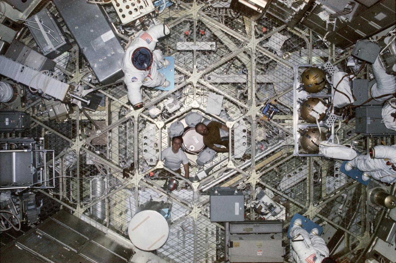
SL4-150-5062 (January 1974) --- A 35mm camera, operated by astronaut William R. Pogue, Skylab 4 pilot, recorded this wide scene of his Skylab 4 crewmates on the other end of the orbital workshop. Astronauts Jerry P. Carr (right), commander, and Edward G. Gibson, science pilot, pose for the snapshot. Also in the frame are parts of three Extravehicular Mobility Unit (EMU) spacesuits, used on several EVA sessions during the third manning of the Skylab space station. Photo credit: NASA
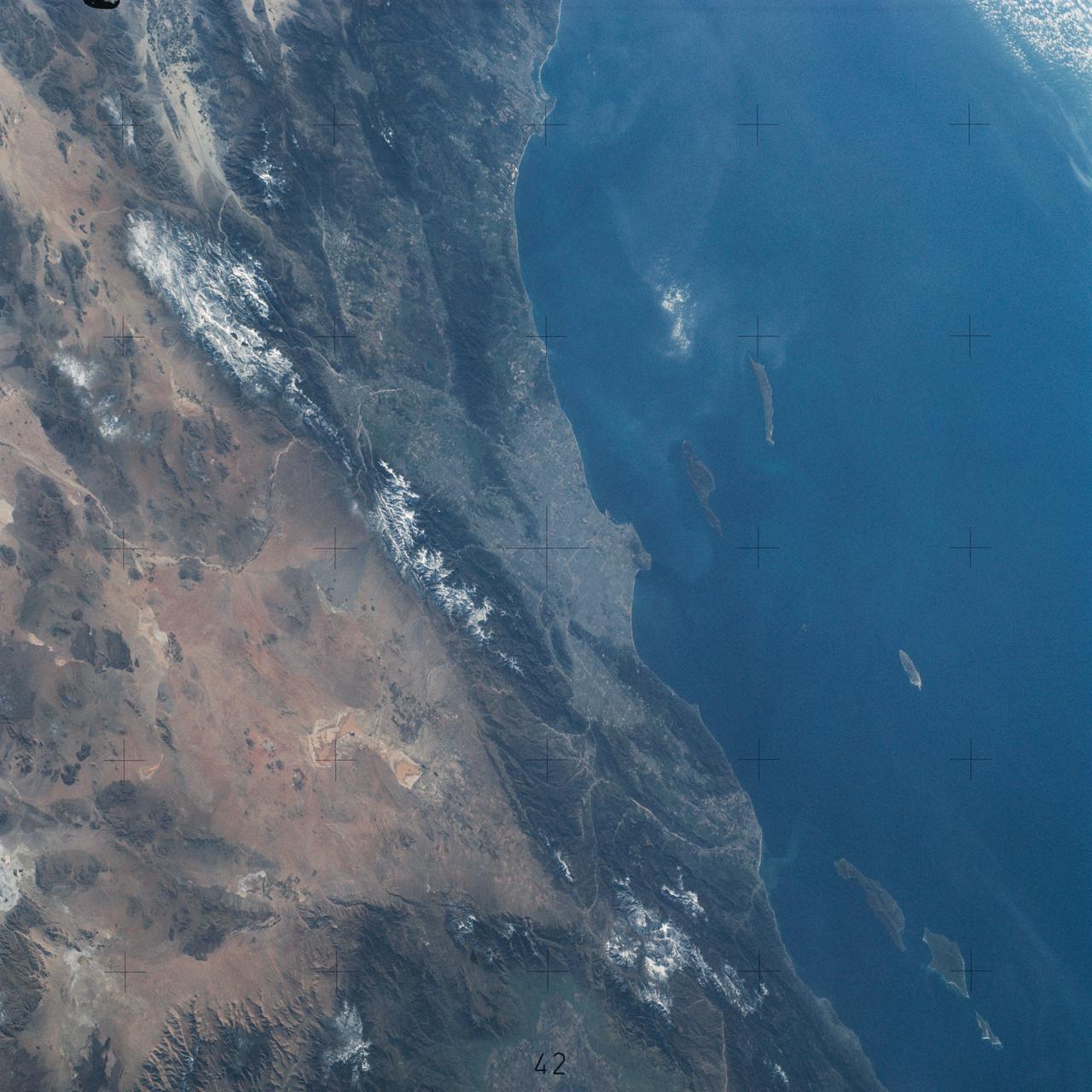
SL4-142-4542 (November 1973-February 1974) --- An oblique view of the Pacific Coast of Southern California, including the Los Angeles and San Diego areas, as seen from the Skylab space station in Earth orbit. This picture was taken by one of the Skylab 4 crewmen using a hand-held 70mm Hasselblad camera with a 100mm lens and SO-368 medium-speed Ektachrome film. The visible coastline extends from San Diego northwesterly to Santa Barbara. The Mojave Desert occupies much of the photograph. This view also includes the Channel Islands off the coast. Note that the higher elevations of the mountains are covered with snow. Photo credit: NASA
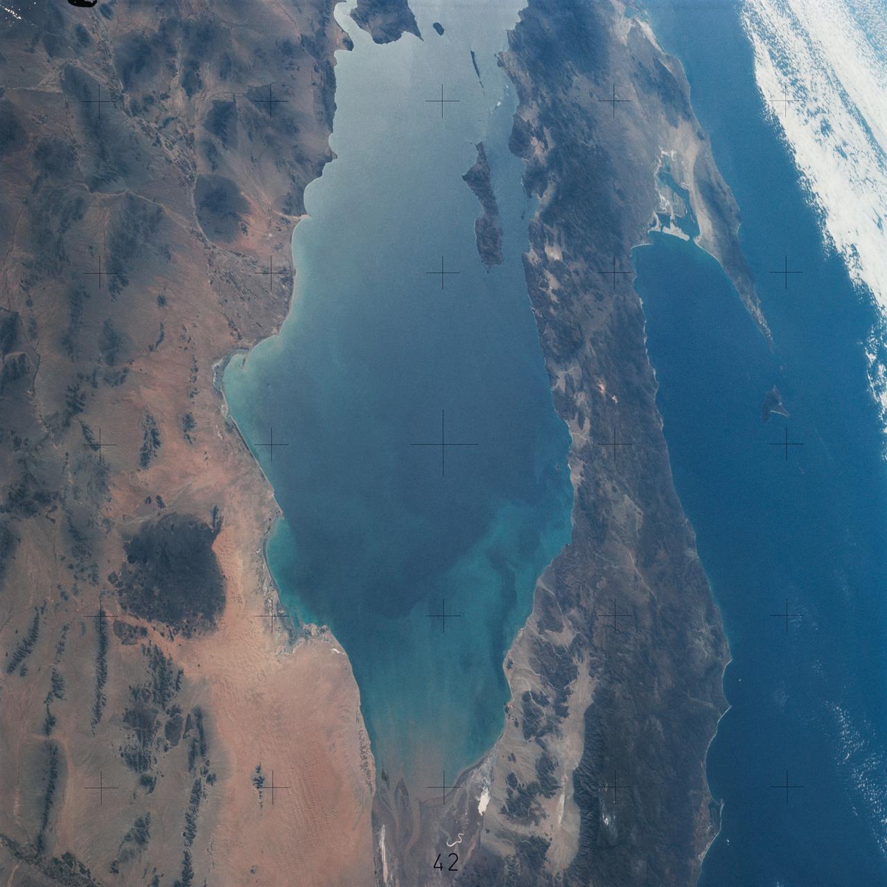
SL4-142-4548 (27 Jan. 1974) --- An oblique view of northwestern Mexico, as photographed from the Skylab space station in Earth orbit by one of the Skylab 4 crewmen. The camera used was a hand-held 70mm Hasselblad, with SO-368 medium-speed Ektachrome film. This photograph was taken on a sweep down the coast to document the fault patterns of southern California and northwest Mexico. SL4-142-4532 gives an excellent overview of the entire region. The specific reason for this picture was an attempt to see if the Agua Blanca Fault in Baja California extends to the east toward the Gulf of California. Several attempts were made by the Skylab 4 crew to visually detect such an extension, but none was found. The report was that the fault disappeared into an area of sand and heavily eroded material that obscured any feature that might be present deeper. This area of sand and loose material is the light-colored area in the center of Baja at the extreme north part of the photograph. In addition to this geology the Pinacate volcanic field in Sonora, the sand dunes in Sonora, and the sediment flow patterns of the Colorado River entering the Gulf are additional areas of study utilizing this photograph. Photo credit: NASA
SL4-138-3843 (1 Jan. 1974) --- A part of northern California centered near San Francisco Bay photographed at 3 p.m. Jan. 2, 1974, from the Skylab space station in Earth orbit. This near vertical view encompasses the coastline from Monterey Bay (right) to about 50 miles north of Point Reyes (left) and includes, from bottom to top, San Francisco Bay (center), Sacramento Valley (left center), San Joaquin Valley (right center), and the snow-covered Sierra Nevada. Afternoon shadows sharply delineate a valley which parallels San Francisco Bay, crosses Point Reyes, and lies between the Bay and the Pacific coastline. This valley marks the location of the San Andreas Fault, a major break in the Earth's crust. Forces acting on the crust are causing the land west (bottom) of the fault line to move north relative to land on the east side. The Skylab 4 astronauts photographed major fault zones in South America, New Zealand, Japan and Africa for use in the study of worldwide tectonic system. Agricultural areas in the Sacramento and San Joaquin Valleys are indicated by the tan areas which are easily discerned in contrast to the green-gray background. Photo credit: NASA
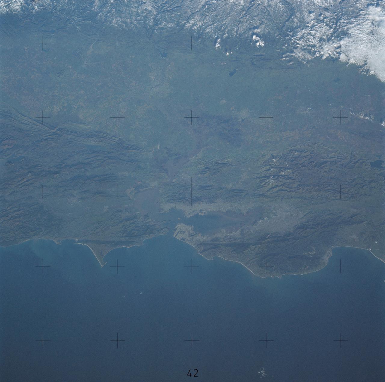
SL4-137-3700 (22 Dec. 1973) --- A near vertical view of a portion of South Island, New Zealand, as see from the Skylab space station in Earth orbit. This picture was taken by one of the Skylab 4 crew members with a handheld 70mm Hasselblad camera using a 100mm lens. The picture should be held with the largest body of water (Tasman Sea) on the left. Cape Foulwind is at the upper left. The City of Christchurch is under clouds at the center right margin. Note the movement of sediment by alongshore currents, especially on the east (right) side of the island. The Alpine Fault, which is part of the circum-Pacific volcanic-tectonic belt, is clearly visible on the left (west) side of the island. The fault line is marked by a scarp, which appears very distinct from orbital altitude. Differences in topography and vegetation on either side of the fault are also sharp. Streams change direction at the fault line, and the change in slope at the fault line is evident in the widening of stream channels. The left side of the fault has moved northeast (upward) relative to the right side; some stream offsets indicate the direction of relative movement, but others are controlled by local topography. The Alpine Fault, which also transects New Zealand's North Island, was photographed and described more than a dozen times by the Skylab 4 crewmen. The circum-Pacific volcanic-tectonic belt is a feature of the Earth's crust which is related to sea floor spreading and continental drift. Though the Alpine Fault is sharply delineated in this photograph, other major crustal features are subtle that their existence was unknown before their observation from orbit. The distance from top to bottom is about 290 kilometers (175 miles). Photo credit: NASA
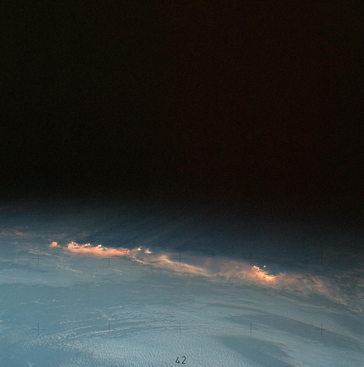
SL4-137-3566 (12 Dec. 1973) --- A group of clouds near New Zealand, as photographed from the Skylab space station in Earth orbit by one of the Skylab 4 crew members. The camera used was a hand-held 70mm Hasselblad with SO-368 medium speed Ektachrome. This picture shows vividly how low sun angles enhance relief, giving these clouds a three-dimensional appearance. In addition to being "pretty," this photograph can be used to study the line of storms seen here at sunset. Relative heights of individuals cells can be measured, as well as their relation to the surrounding clouds. Photo credit: NASA
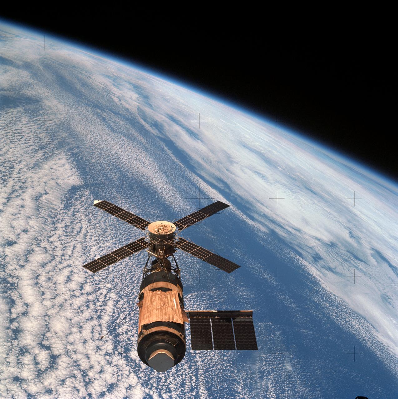
SL4-143-4706 (8 Feb. 1974) --- An overhead view of the Skylab space station cluster in Earth orbit as photographed from the Skylab 4 Command and Service Modules (CSM) during the final fly-around by the CSM before returning home. The space station is contrasted against a cloud-covered Earth. Note the solar shield which was deployed by the second crew of Skylab and from which a micro meteoroid shield has been missing since the cluster was launched on May 14, 1973. The Orbital Workshop (OWS) solar panel on the left side was also lost on workshop launch day. Inside the Command Module (CM) when this picture was made were astronaut Gerald P. Carr, commander; scientist-astronaut Edward G. Gibson, science pilot; and astronaut William R. Pogue, pilot. The crew used a 70mm hand-held Hasselblad camera to take this photograph. Photo credit: NASA
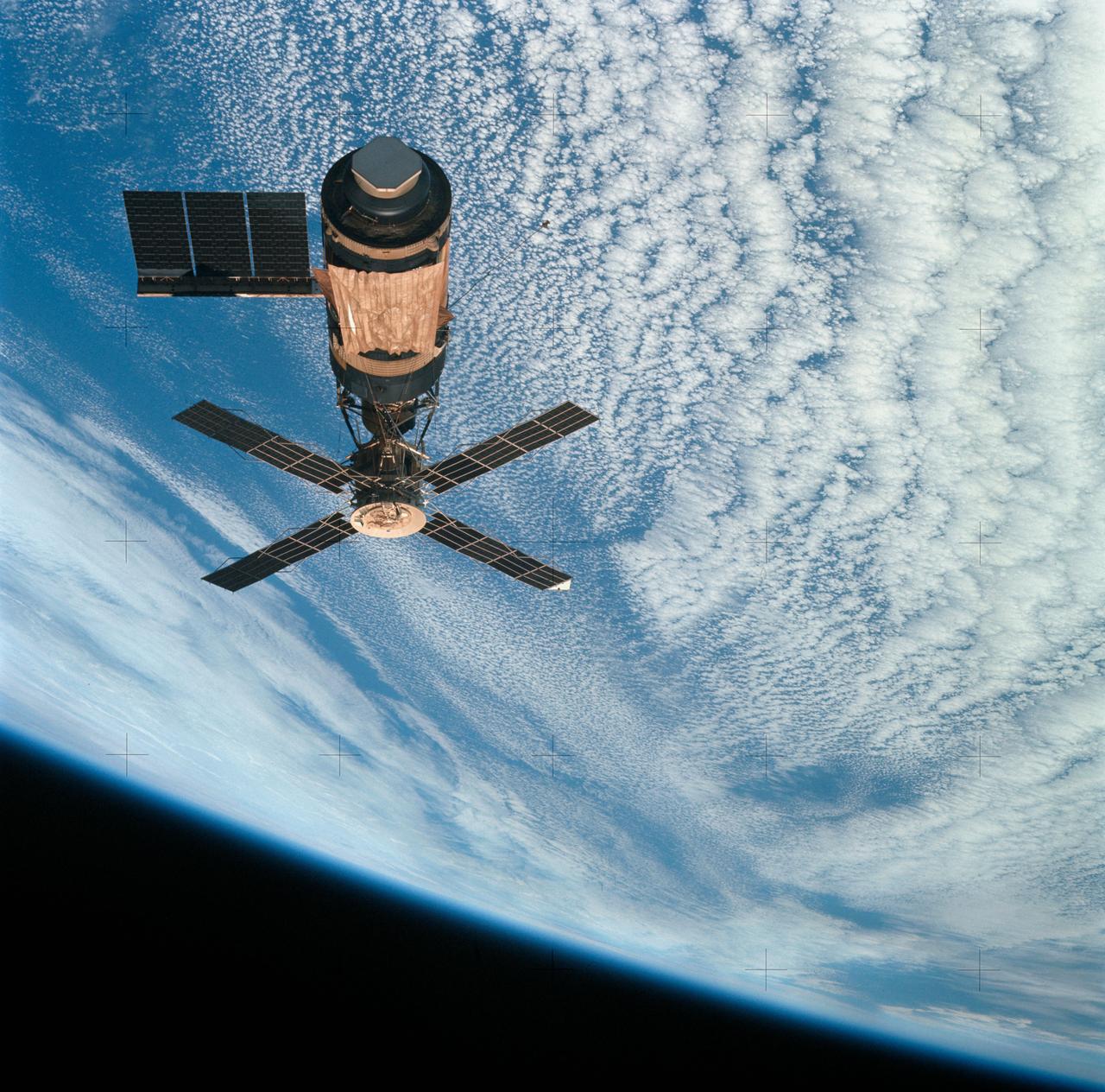
SL4-143-4707 (8 Feb. 1974) --- An overhead view of the Skylab space station cluster in Earth orbit as photographed from the Skylab 4 Command and Service Modules (CSM) during the final fly-around by the CSM before returning home. The space station is contrasted against a cloud-covered Earth. Note the solar shield which was deployed by the second crew of Skylab and from which a micrometeoroid shield has been missing since the cluster was launched on May 14, 1973. The OWS solar panel on the left side was also lost on workshop launch day. Photo credit: NASA
SL4-138-3756 (28 Dec. 1973) --- The northern half of Mauritania's Atlantic Coast, as photographed from the Skylab space station in Earth orbit by one of the Skylab 4 crewmen. The camera used was a hand-held 70mm Hasselblad, with SO-368 medium-speed Ektachrome. Spanish Sahara is just out of the picture to the north. The linear chains of sand dunes leading to the sea were the objects of study in an effort to better understand deserts and their formations. Photographs such as this were compared with similar ones taken over the drought-stricken areas including Mali and Niger in an attempt to understand the desertification processes which may be occurring there. Photo credit: NASA
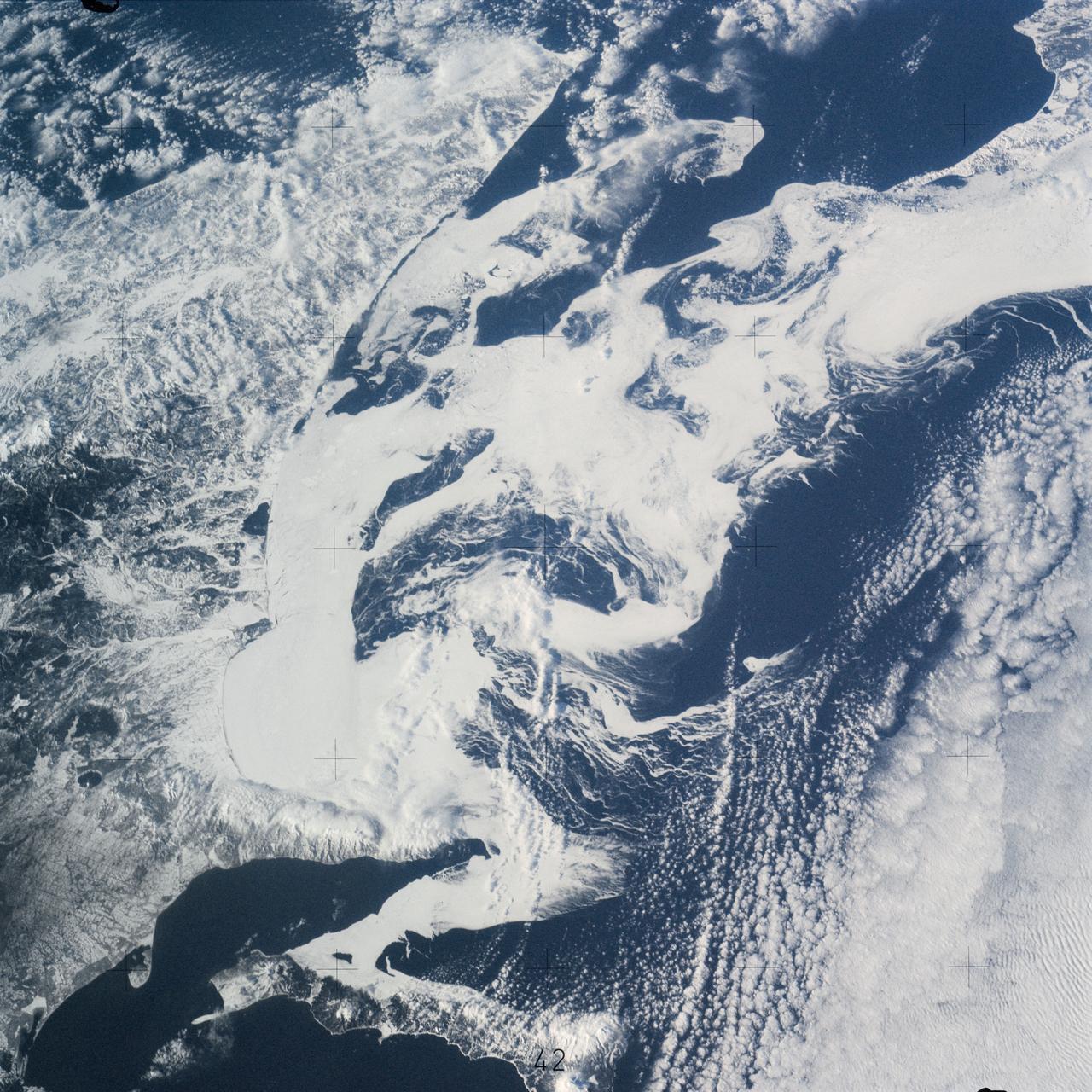
SL4-141-4316 (20 Jan. 1974) --- An oblique view of ice formations in Canada's Hudson Bay, as photographed from the Skylab space station in Earth orbit by one of the Skylab 4 crewmen. The camera used was a hand-held 70mm Hasselblad, with SO-368 medium-speed Ektachrome film. The southwestern part of the bay is prominent with the Nelson River in Manitoba flowing into it. Skylab never flew this far north in latitude. However, its orbital vantage point allowed observations and photography while over a point some 600 miles away as in the case of this picture. The ice formation along the southwest portion of Hudson Bay can be studied from photographs such as this one. The buildup of ice along the windward shore (very white) followed by the clear water gap (dark) caused by the wind blowing the newly formed ice toward the opposite shore, and finally the patterns in the ice structure itself are studied to learn more of the nature of the "winterization" of this area. Photo credit: NASA
SL4-137-3655 (16 Dec. 1973) --- An island wake produced by the Antipodes Islands in the ocean current south of New Zealand is seen in this photograph taken from the Skylab space station in Earth orbit. A Skylab 4 crewmen took the picture with a hand-held 70mm Hasselblad camera. The bow wave pattern is quite evident and can be used to determine the current speed from the angle of the bow wave if the propagation speed of the surface wave is known. Also, evident is the darker band extending downstream from the island tens of miles. This is the actual wake of the island. The existence of water color differences from within to outside a turbulent island wake may indicate a temperature difference, with cooler water being stirred to the surface in the wake. This temperature difference could be used to drive a thermo-electric type generator to reduce small islands' dependence on imported oil for power generation. Photo credit: NASA
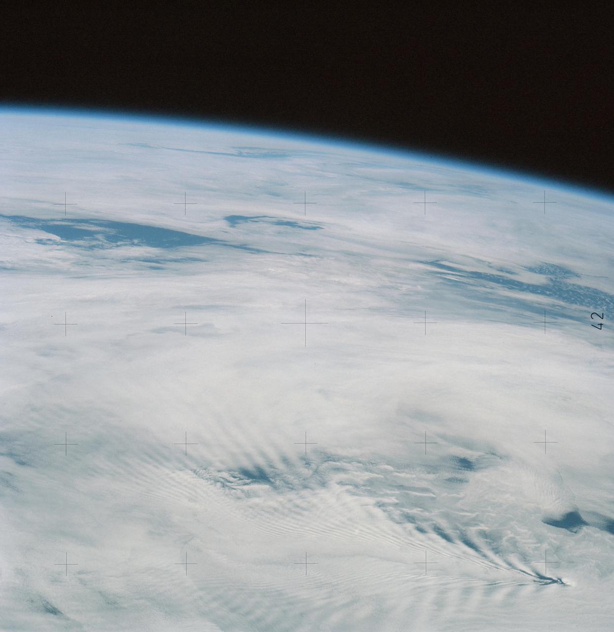
SL4-137-3632 (February 1974) --- A photograph taken from the Skylab space station in Earth orbit illustrating an atmospheric wave pattern by the affect of a small mountainous island on wind currents. Various patterns can be seen downwind of small islands. Often a Von Karmon vortex can be seen which appears as a spiral pattern. Multiple vortices have been photographed on previous missions. This photograph illustrates a "bow wave" pattern which extends for hundreds of miles downwind from the island. The island itself is often clear when a wave pattern is formed downstream. This particular pattern is very symmetrical. These wave patterns are most common in the South Pacific. This picture was taken by a Skylab 4 crewmen using a hand-held 70mm Hasselblad camera. Photo credit: NASA
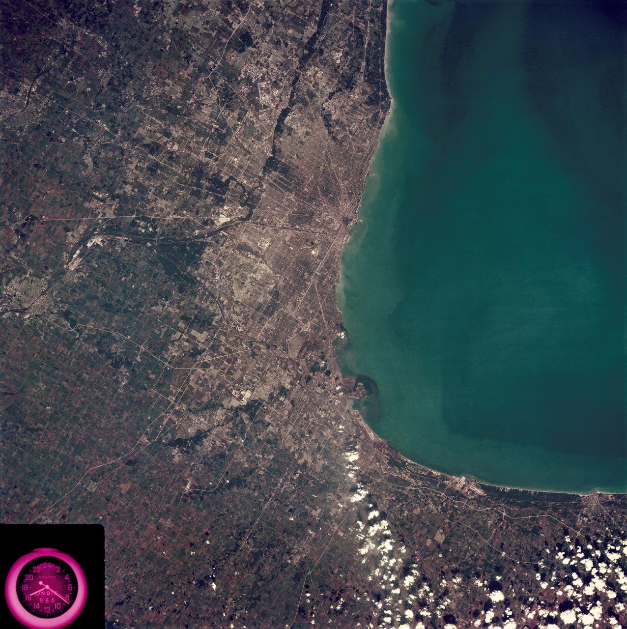
SL3-88-222 (18 Sept. 1973) --- The metropolitan area of Chicago is encompassed in this Skylab 3 Earth Resources Experiments Package (EREP) S190-B photograph taken on Sept. 18, 1973 from the Skylab space station cluster in Earth orbit. The surrounding major cities of Aurora and Joliet, Illinois; Hammond, Gary and East Chicago, Indiana, are easily delineated. The photograph reveals the following: (1) Cultural differentiation of commercial, industrial and residential areas for use in population and social studies in micro-macro community planning and in cultural pattern studies in the improvement of urban areas. (Aurora is one of 27 census cities of interest to Robert Alexander, a principal investigator. Alexander is with the U.S. Geological Survey). (2) The transportation network with major corridors and their interchanges, primary and feeder streets for use in network analysis and in the development of models for population movement and land use projection. (3) The agricultural lands for land use identification on crop inventory analysis; airports for use in delineation of service and infringement of major man-made features that affect ecosystem balance (support to environmental impact studies). (4) Air and water plumes for use in case studies, natural and man-made differentiation of pollution sources, in support of model development and in ecosystem research studies on the effects of pollution. (5) Recreational centers for use in relating recreational centers to population centers, establishing possible demands and in development of possible future recreational centers to support the demand. All EREP photography is available to the public through the Department of Interior?s Earth Resources Observations Systems Data Center, Sioux Falls, South Dakota, 57198. Photo credit: NASA