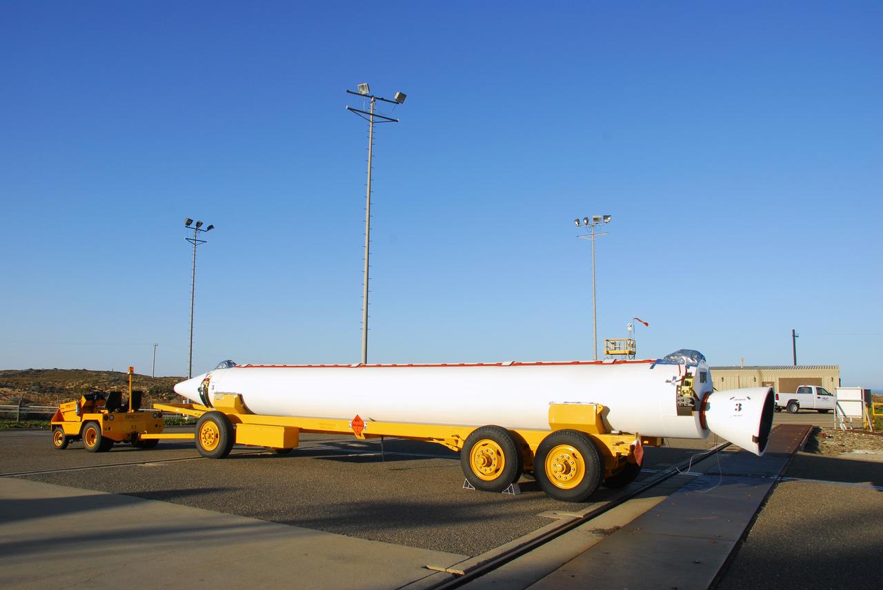
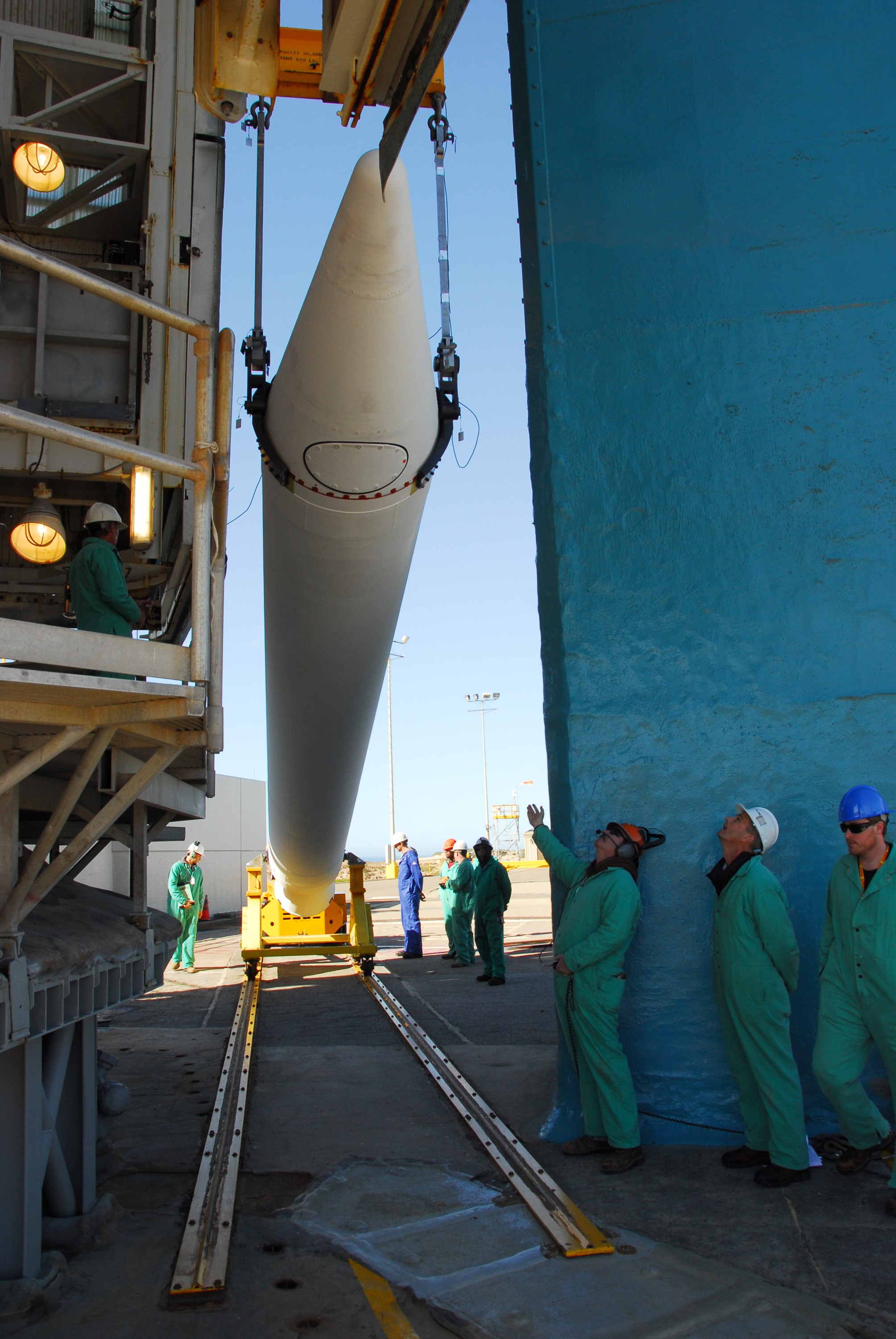
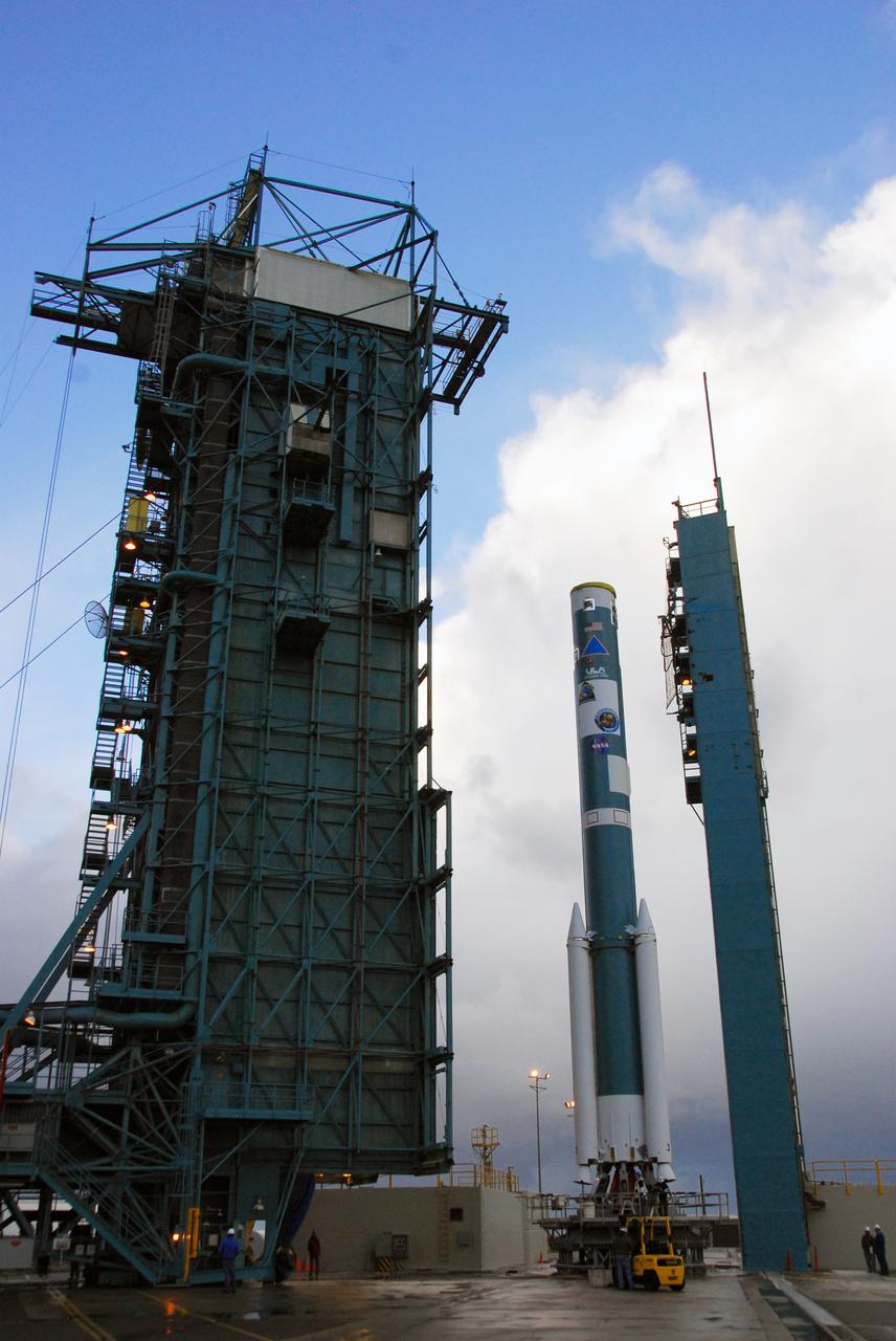
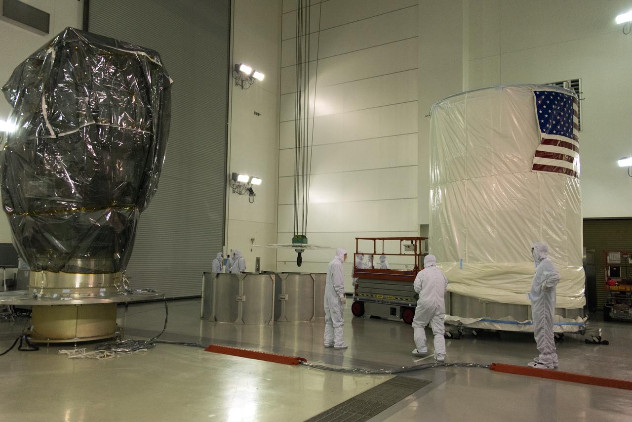
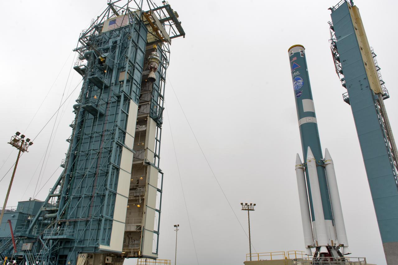
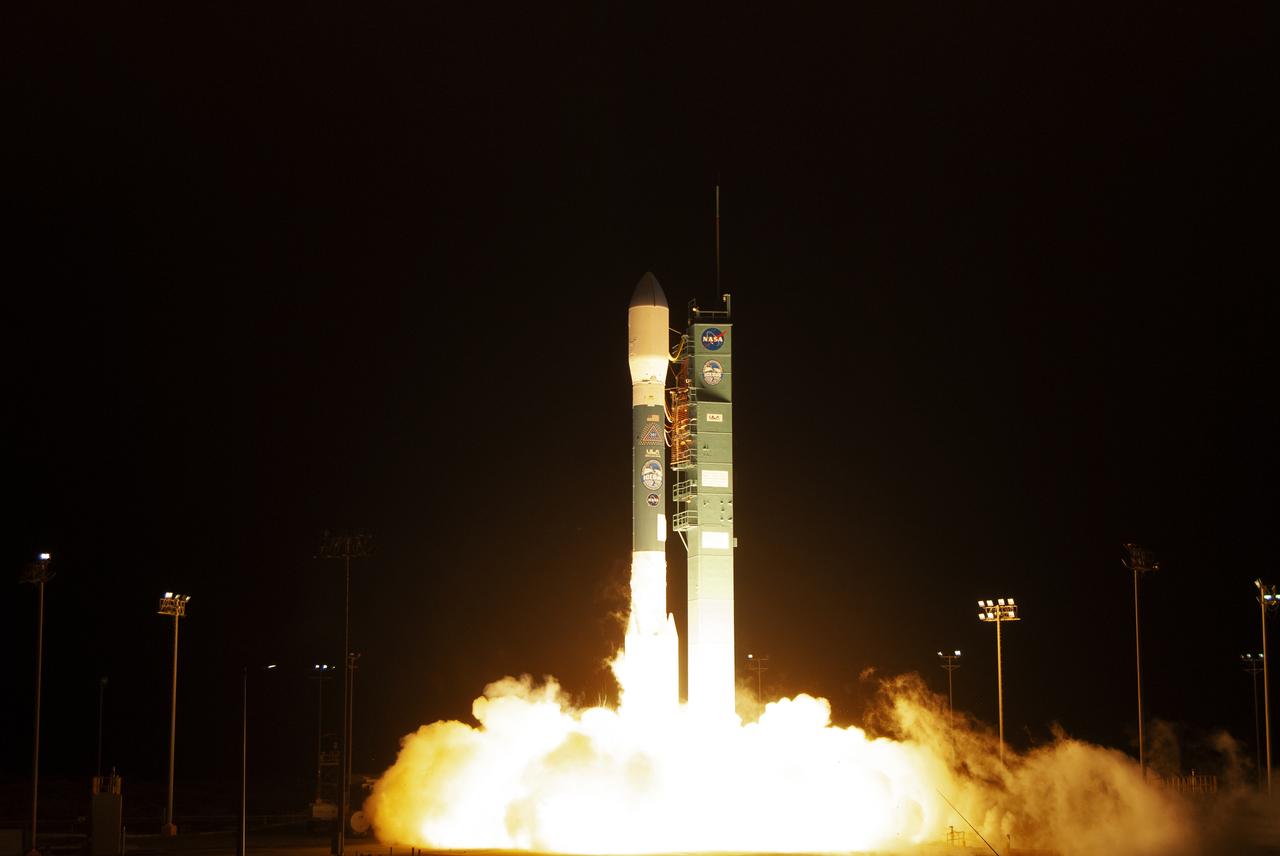
VANDENBERG AIR FORCE BASE, Calif. --At Vandenberg Air Force Base in California, one of three United Space Alliance Delta II solid rocket motors is atop a tug for the move from the solid motor facility to Space Launch Complex-2 West (SLC-2W). Scheduled to launch in June, the Delta II rocket will carry NASA's Aquarius satellite into low Earth orbit. Aquarius' mission will be to provide monthly maps of global changes in sea surface salinity. By measuring ocean salinity from space, Aquarius will provide new insights into how the massive natural exchange of freshwater between the ocean, atmosphere and sea ice influences ocean circulation, weather and climate. Also going up with the satellite are optical and thermal cameras, a microwave radiometer and the SAC-D spacecraft, which were developed with the help of institutions in Italy, France, Canada and Argentina. Photo credit: VAFB/30th Space Wing

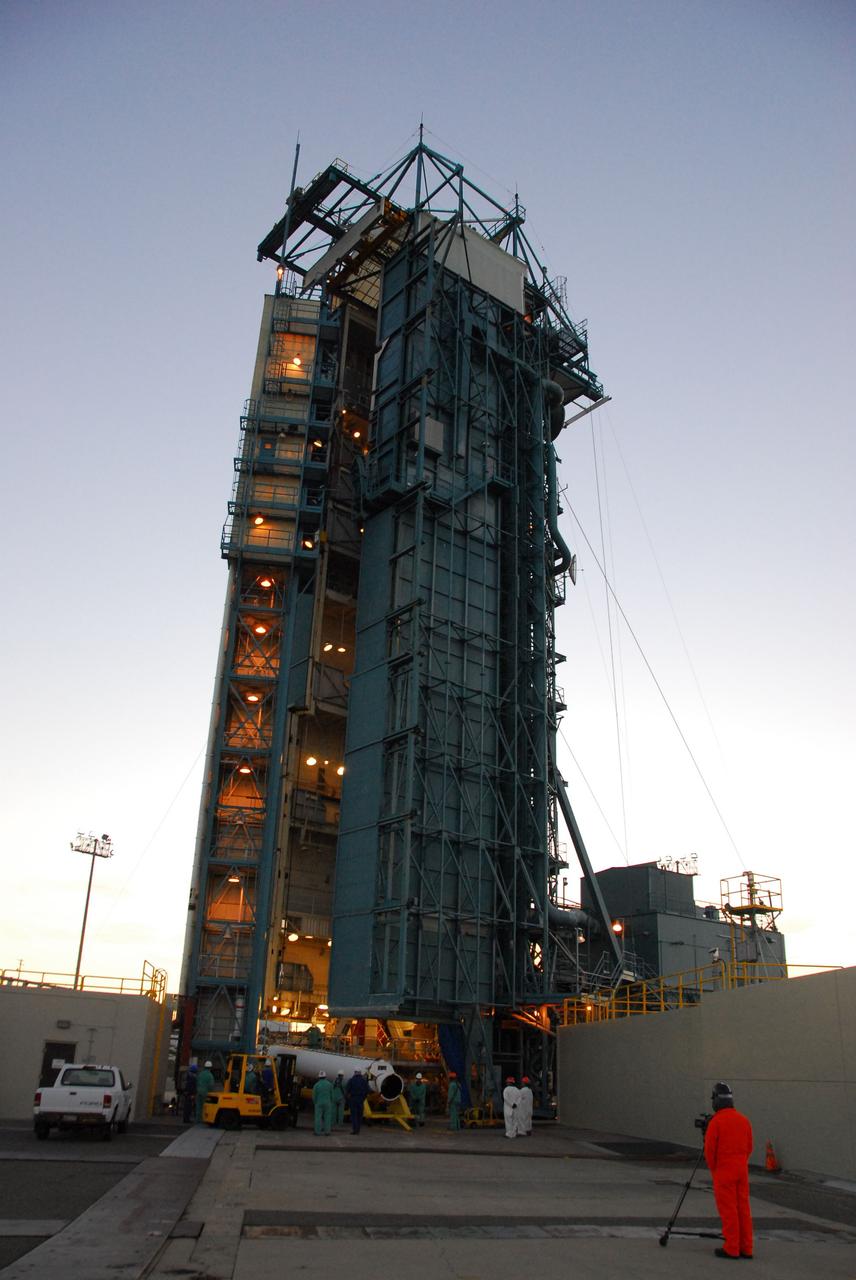
VANDENBERG AIR FORCE BASE, Calif. --As the sun rises over Vandenberg Air Force Base in California, a crane begins to raise one of three United Launch Alliance Delta II solid rocket motors on the pad at Space Launch Complex-2 West (SLC-2W). Scheduled to launch in June, the Delta II rocket will carry NASA's Aquarius satellite into low Earth orbit. Aquarius' mission will be to provide monthly maps of global changes in sea surface salinity. By measuring ocean salinity from space, Aquarius will provide new insights into how the massive natural exchange of freshwater between the ocean, atmosphere and sea ice influences ocean circulation, weather and climate. Also going up with the satellite are optical and thermal cameras, a microwave radiometer and the SAC-D spacecraft, which were developed with the help of institutions in Italy, France, Canada and Argentina. Photo credit: VAFB/30th Space Wing
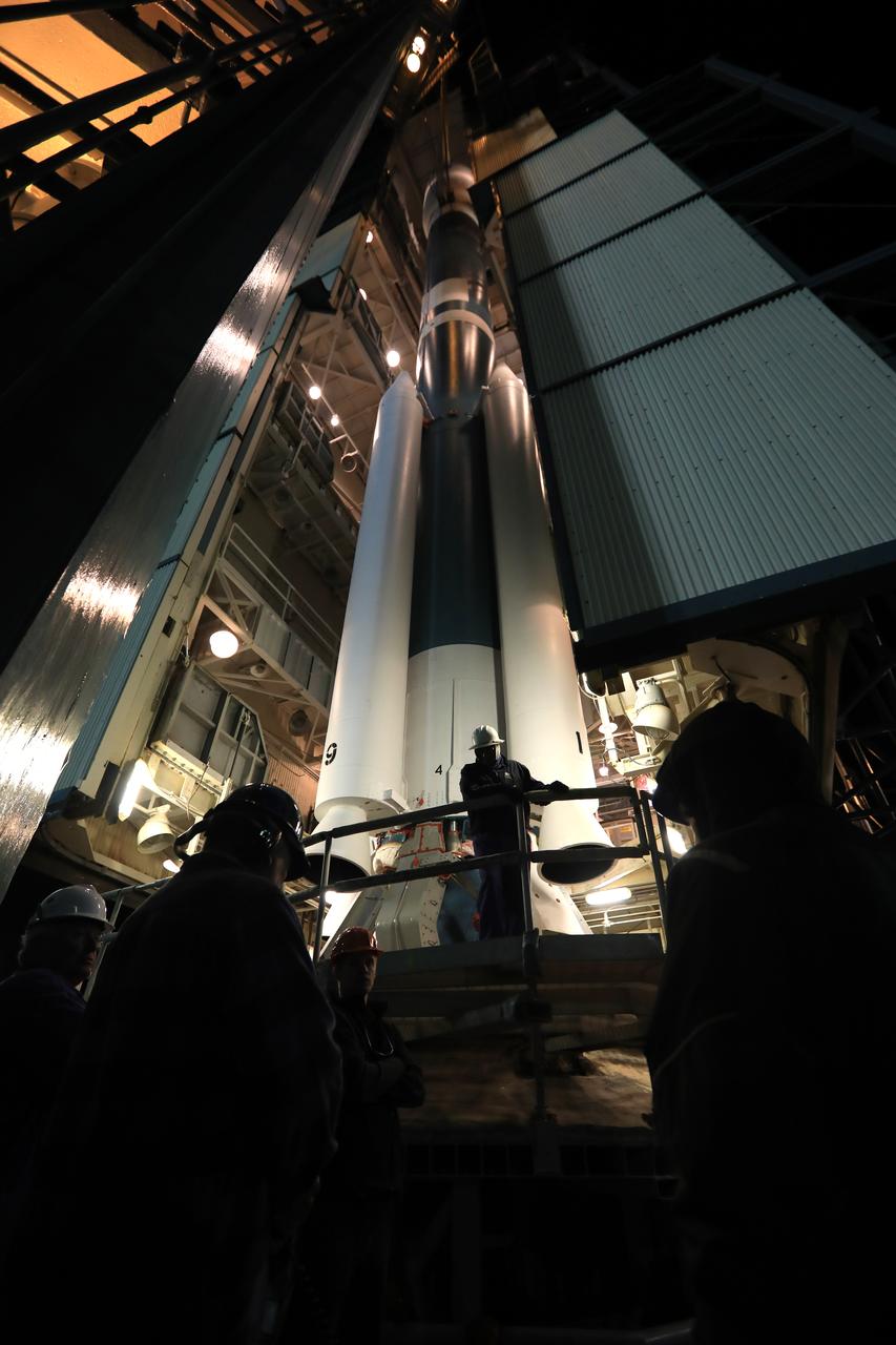
VANDENBERG AIR FORCE BASE, Calif. --At Vandenberg Air Force Base in California, United Launch Alliance technicians finish installing one of three Delta II solid rocket motors on the pad at Space Launch Complex-2 West (SLC-2W). A second motor was installed earlier in the morning. Scheduled to launch in June, the Delta II rocket will carry NASA's Aquarius satellite into low Earth orbit. Aquarius' mission will be to provide monthly maps of global changes in sea surface salinity. By measuring ocean salinity from space, Aquarius will provide new insights into how the massive natural exchange of freshwater between the ocean, atmosphere and sea ice influences ocean circulation, weather and climate. Also going up with the satellite are optical and thermal cameras, a microwave radiometer and the SAC-D spacecraft, which were developed with the help of institutions in Italy, France, Canada and Argentina. Photo credit: VAFB/30th Space Wing
VANDENBERG AIR FORCE BASE, Calif. --As the sun rises over Vandenberg Air Force Base in California, a crane raises one of three United Launch Alliance Delta II solid rocket motors on the pad at Space Launch Complex-2 West (SLC-2W). Scheduled to launch in June, the Delta II rocket will carry NASA's Aquarius satellite into low Earth orbit. Aquarius' mission will be to provide monthly maps of global changes in sea surface salinity. By measuring ocean salinity from space, Aquarius will provide new insights into how the massive natural exchange of freshwater between the ocean, atmosphere and sea ice influences ocean circulation, weather and climate. Also going up with the satellite are optical and thermal cameras, a microwave radiometer and the SAC-D spacecraft, which were developed with the help of institutions in Italy, France, Canada and Argentina. Photo credit: VAFB/30th Space Wing
VANDENBERG AIR FORCE BASE, Calif. --As the sun rises over Vandenberg Air Force Base in California, United Launch Alliance technicians prepare to raise one of three Delta II solid rocket motors on the pad at Space Launch Complex-2 West (SLC-2W). Scheduled to launch in June, the Delta II rocket will carry NASA's Aquarius satellite into low Earth orbit. Aquarius' mission will be to provide monthly maps of global changes in sea surface salinity. By measuring ocean salinity from space, Aquarius will provide new insights into how the massive natural exchange of freshwater between the ocean, atmosphere and sea ice influences ocean circulation, weather and climate. Also going up with the satellite are optical and thermal cameras, a microwave radiometer and the SAC-D spacecraft, which were developed with the help of institutions in Italy, France, Canada and Argentina. Photo credit: VAFB/30th Space Wing
VANDENBERG AIR FORCE BASE, Calif. --As the sun rises over Vandenberg Air Force Base in California, a crane raises one of three United Launch Alliance Delta II solid rocket motors on the pad at Space Launch Complex-2 West (SLC-2W). Scheduled to launch in June, the Delta II rocket will carry NASA's Aquarius satellite into low Earth orbit. Aquarius' mission will be to provide monthly maps of global changes in sea surface salinity. By measuring ocean salinity from space, Aquarius will provide new insights into how the massive natural exchange of freshwater between the ocean, atmosphere and sea ice influences ocean circulation, weather and climate. Also going up with the satellite are optical and thermal cameras, a microwave radiometer and the SAC-D spacecraft, which were developed with the help of institutions in Italy, France, Canada and Argentina. Photo credit: VAFB/30th Space Wing
VANDENBERG AIR FORCE BASE, Calif. --At Vandenberg Air Force Base in California, a crane raises one of three United Launch Alliance Delta II solid rocket motors on the pad at Space Launch Complex-2 West (SLC-2W). A second motor was installed earlier in the morning. Scheduled to launch in June, the Delta II rocket will carry NASA's Aquarius satellite into low Earth orbit. Aquarius' mission will be to provide monthly maps of global changes in sea surface salinity. By measuring ocean salinity from space, Aquarius will provide new insights into how the massive natural exchange of freshwater between the ocean, atmosphere and sea ice influences ocean circulation, weather and climate. Also going up with the satellite are optical and thermal cameras, a microwave radiometer and the SAC-D spacecraft, which were developed with the help of institutions in Italy, France, Canada and Argentina. Photo credit: VAFB/30th Space Wing
VANDENBERG AIR FORCE BASE, Calif. --At Vandenberg Air Force Base in California, a crane raises one of three United Launch Alliance Delta II solid rocket motors on the pad at Space Launch Complex-2 West (SLC-2W). Scheduled to launch in June, the Delta II rocket will carry NASA's Aquarius satellite into low Earth orbit. Aquarius' mission will be to provide monthly maps of global changes in sea surface salinity. By measuring ocean salinity from space, Aquarius will provide new insights into how the massive natural exchange of freshwater between the ocean, atmosphere and sea ice influences ocean circulation, weather and climate. Also going up with the satellite are optical and thermal cameras, a microwave radiometer and the SAC-D spacecraft, which were developed with the help of institutions in Italy, France, Canada and Argentina. Photo credit: VAFB/30th Space Wing
VANDENBERG AIR FORCE BASE, Calif. --As the sun rises over Vandenberg Air Force Base in California, United Launch Alliance technicians prepare to raise one of three Delta II solid rocket motors on the pad at Space Launch Complex-2 West (SLC-2W). Scheduled to launch in June, the Delta II rocket will carry NASA's Aquarius satellite into low Earth orbit. Aquarius' mission will be to provide monthly maps of global changes in sea surface salinity. By measuring ocean salinity from space, Aquarius will provide new insights into how the massive natural exchange of freshwater between the ocean, atmosphere and sea ice influences ocean circulation, weather and climate. Also going up with the satellite are optical and thermal cameras, a microwave radiometer and the SAC-D spacecraft, which were developed with the help of institutions in Italy, France, Canada and Argentina. Photo credit: VAFB/30th Space Wing
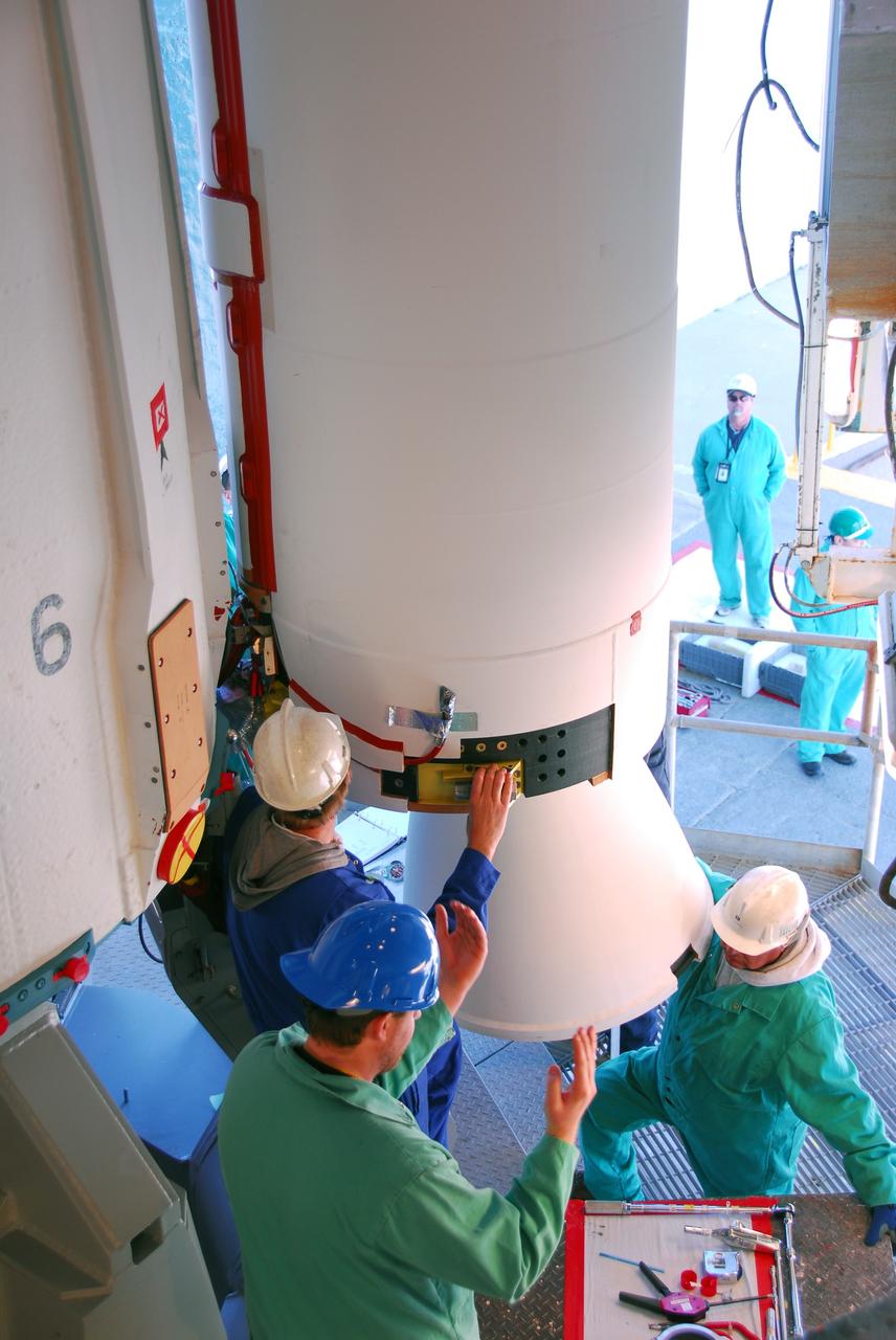
VANDENBERG AIR FORCE BASE, Calif. --At Vandenberg Air Force Base in California, United Launch Alliance technicians finish installing one of three Delta II solid rocket motors on the pad at Space Launch Complex-2 West (SLC-2W). Scheduled to launch in June, the Delta II rocket will carry NASA's Aquarius satellite into low Earth orbit. Aquarius' mission will be to provide monthly maps of global changes in sea surface salinity. By measuring ocean salinity from space, Aquarius will provide new insights into how the massive natural exchange of freshwater between the ocean, atmosphere and sea ice influences ocean circulation, weather and climate. Also going up with the satellite are optical and thermal cameras, a microwave radiometer and the SAC-D spacecraft, which were developed with the help of institutions in Italy, France, Canada and Argentina. Photo credit: VAFB/30th Space Wing
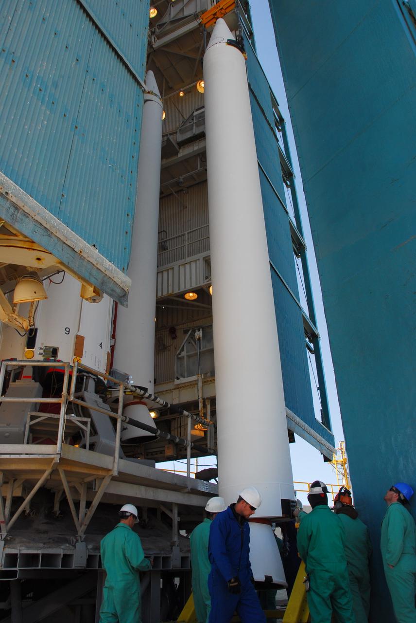
VANDENBERG AIR FORCE BASE, Calif. --At Vandenberg Air Force Base in California, a crane raises one of three United Launch Alliance Delta II solid rocket motors on the pad at Space Launch Complex-2 West (SLC-2W). A second motor was installed earlier in the morning. Scheduled to launch in June, the Delta II rocket will carry NASA's Aquarius satellite into low Earth orbit. Aquarius' mission will be to provide monthly maps of global changes in sea surface salinity. By measuring ocean salinity from space, Aquarius will provide new insights into how the massive natural exchange of freshwater between the ocean, atmosphere and sea ice influences ocean circulation, weather and climate. Also going up with the satellite are optical and thermal cameras, a microwave radiometer and the SAC-D spacecraft, which were developed with the help of institutions in Italy, France, Canada and Argentina. Photo credit: VAFB/30th Space Wing

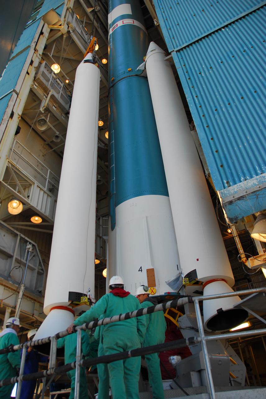
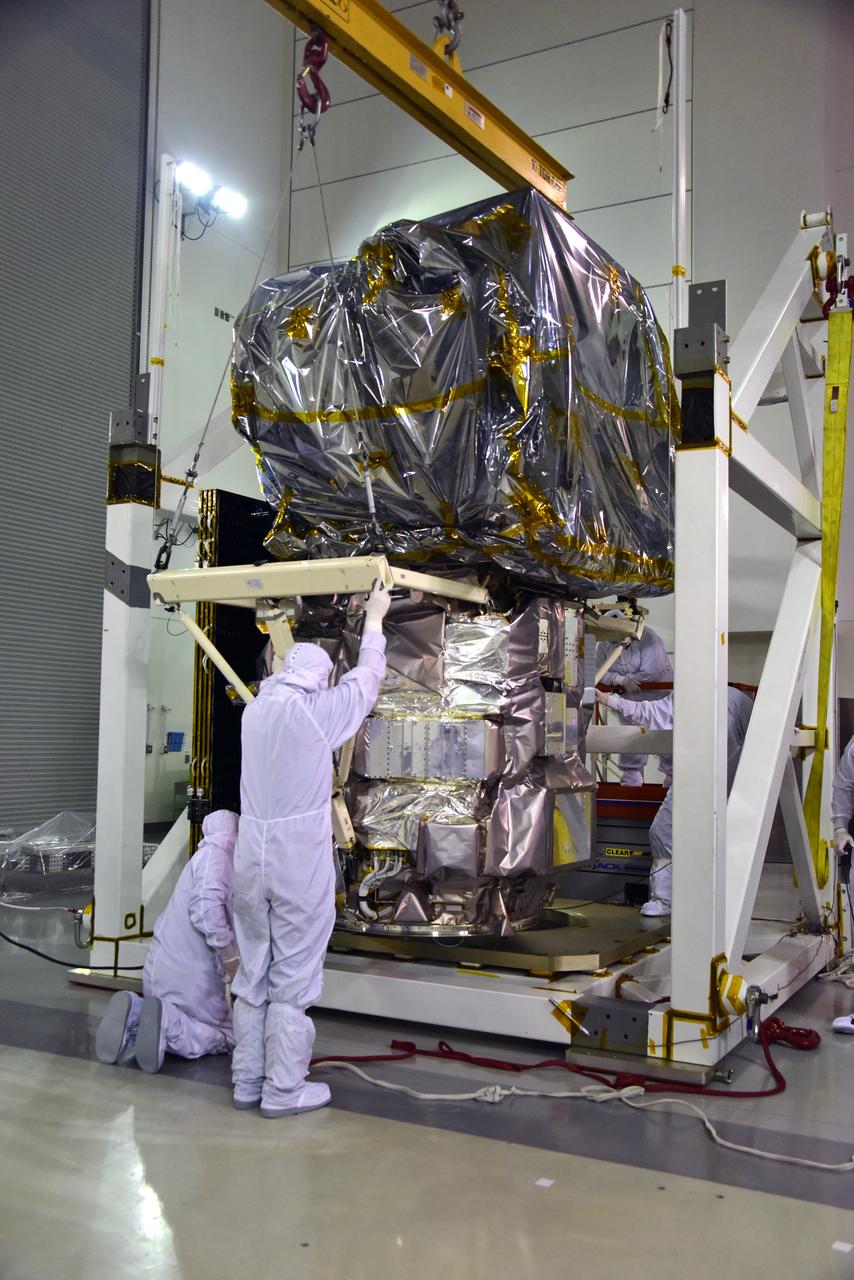
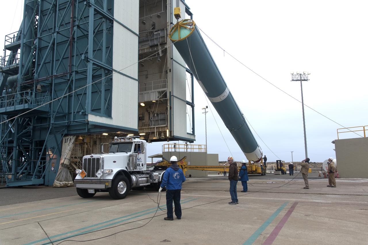
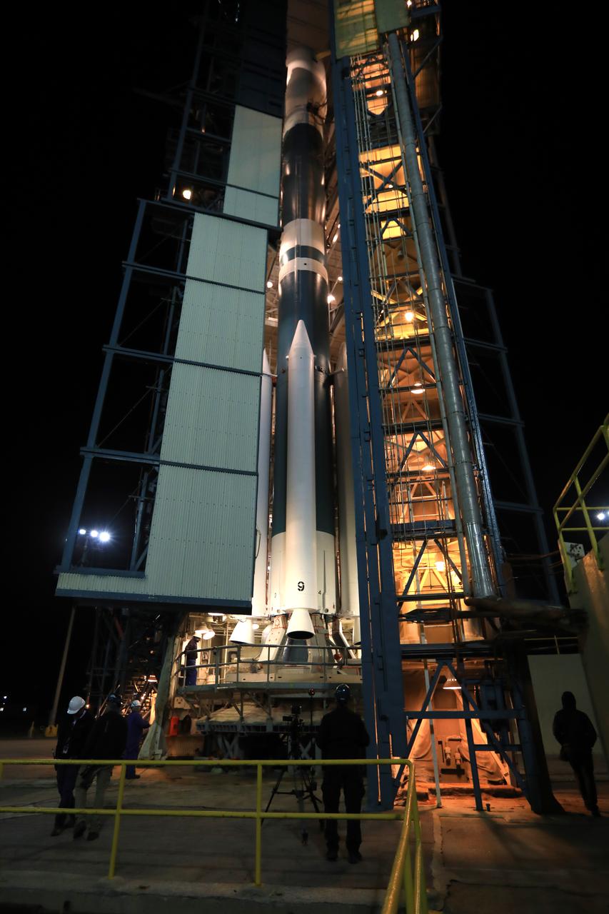
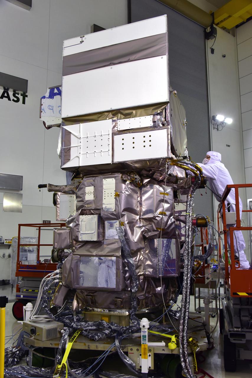
AQUARIUS - Second Stage Erection
AQUARIUS - Second Stage Erection
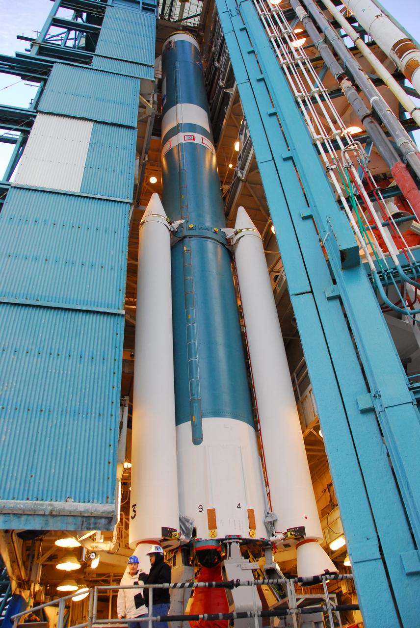
AQUARIUS - Second Stage Erection
AQUARIUS - Second Stage Erection
AQUARIUS - Second Stage Erection
AQUARIUS - Second Stage Erection
AQUARIUS - Second Stage Erection
AQUARIUS - Second Stage Erection
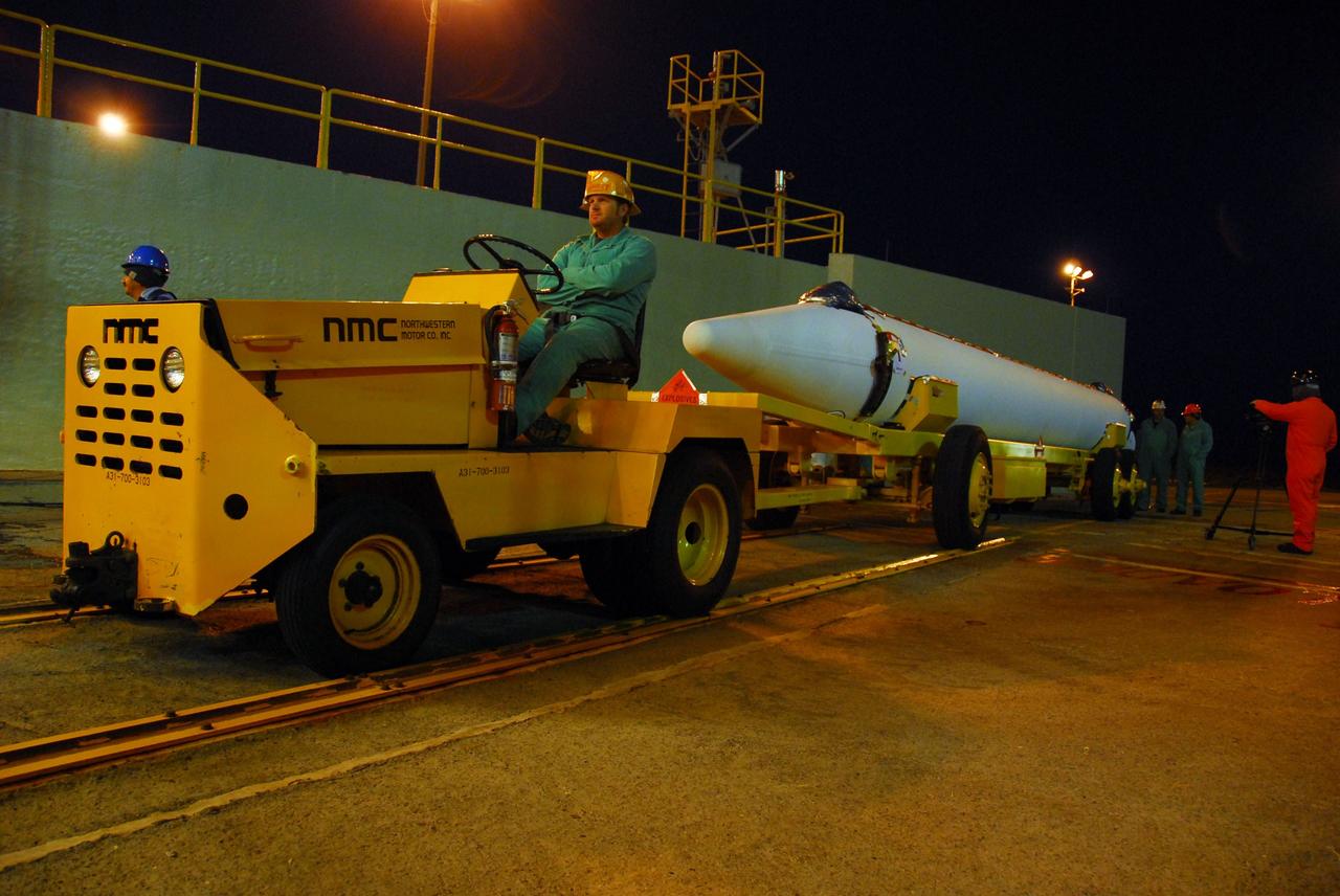
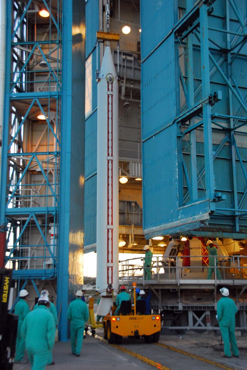
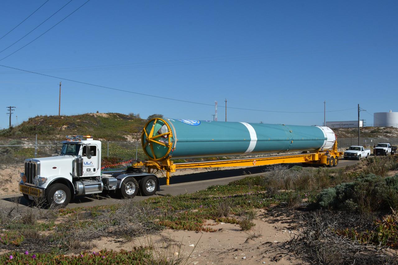
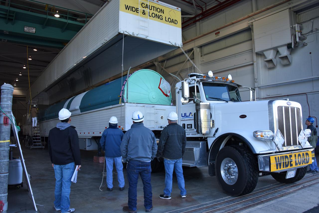
VANDENBERG AIR FORCE BASE, Calif. --Before the sun rises over Vandenberg Air Force Base in California, United Launch Alliance technicians prepare to move one of three Delta II solid rocket motors from the solid motor facility to Space Launch Complex-2 West (SLC-2W) atop a tug. ULA technician Eric Chambless is in the tug's driver seat. Scheduled to launch in June, the Delta II rocket will carry NASA's Aquarius satellite into low Earth orbit. Aquarius' mission will be to provide monthly maps of global changes in sea surface salinity. By measuring ocean salinity from space, Aquarius will provide new insights into how the massive natural exchange of freshwater between the ocean, atmosphere and sea ice influences ocean circulation, weather and climate. Also going up with the satellite are optical and thermal cameras, a microwave radiometer and the SAC-D spacecraft, which were developed with the help of institutions in Italy, France, Canada and Argentina. Photo credit: VAFB/30th Space Wing
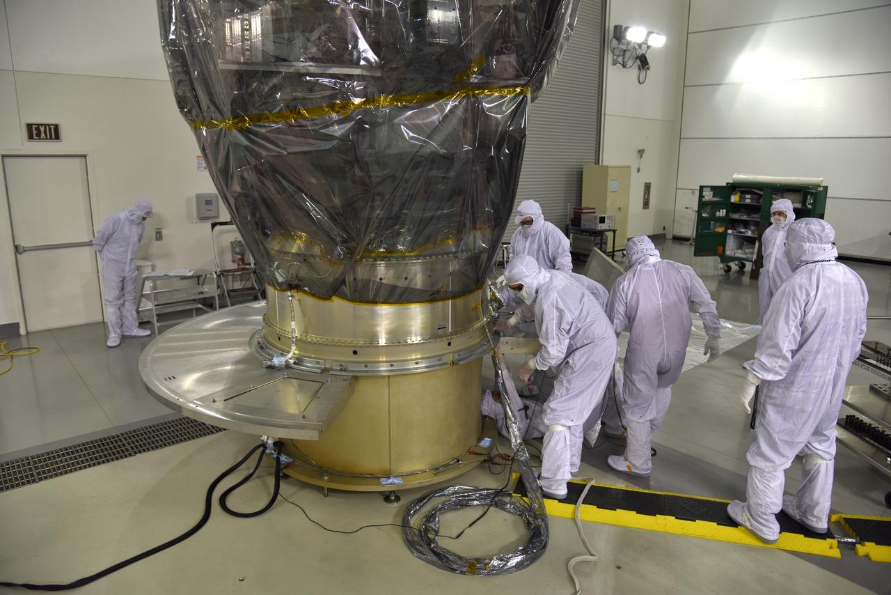
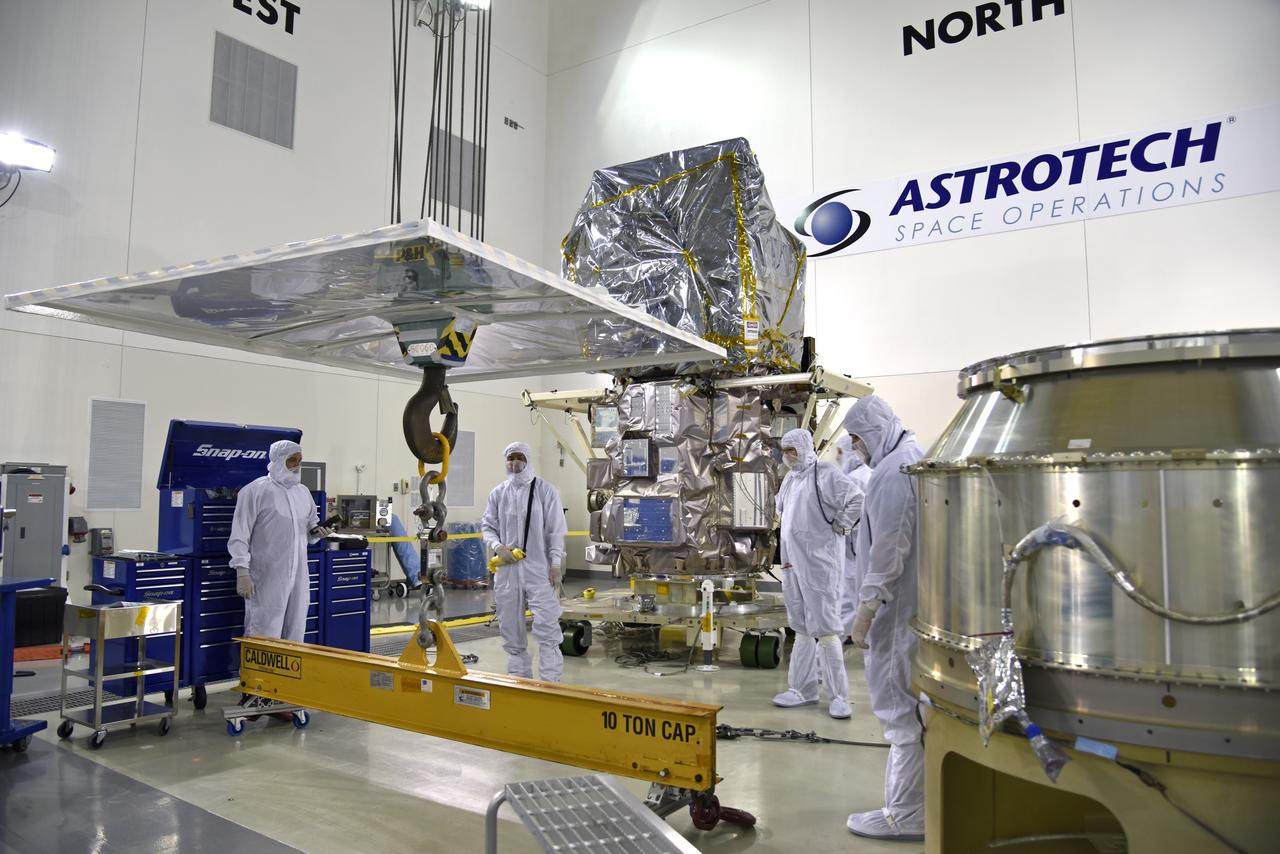
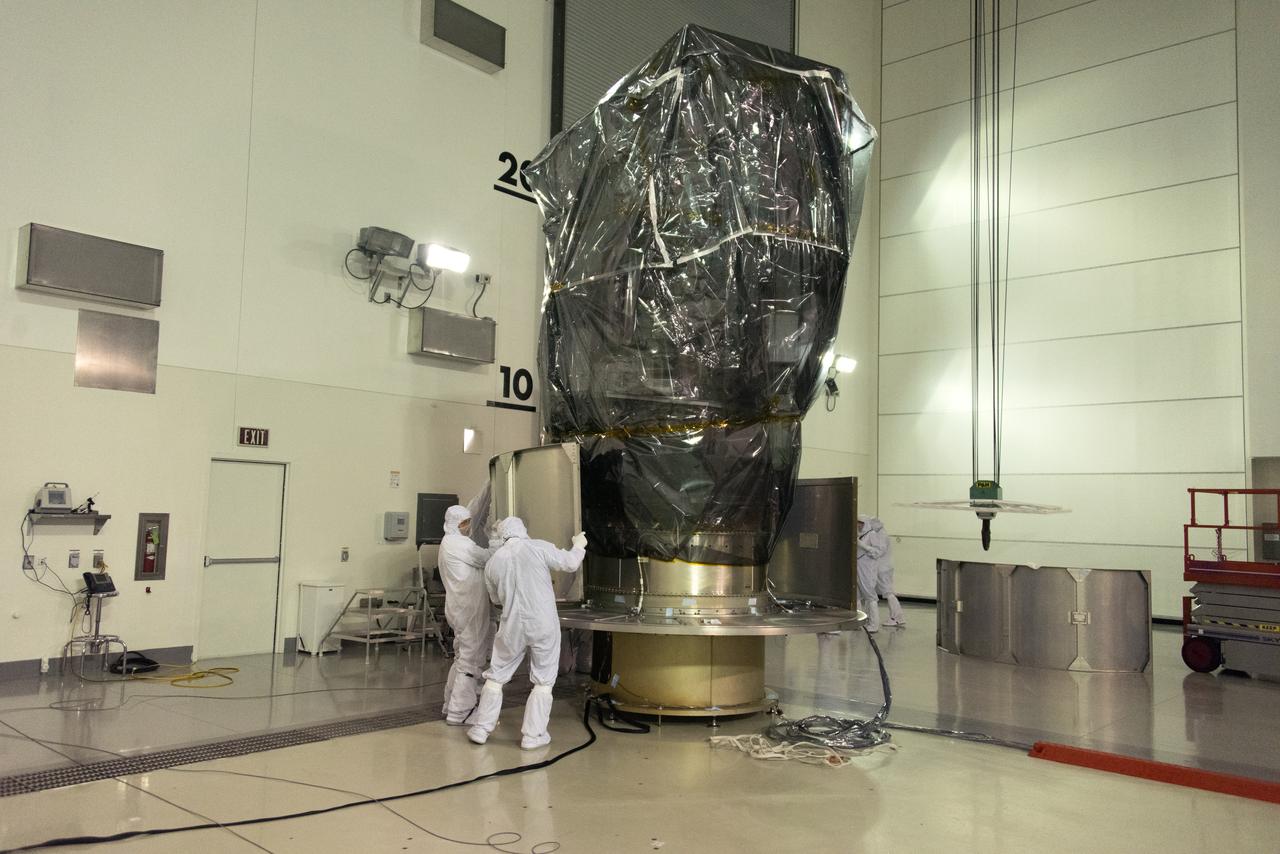
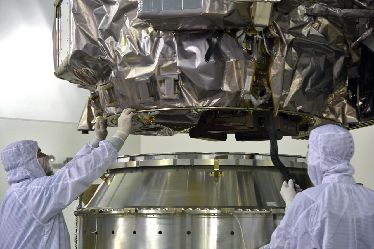
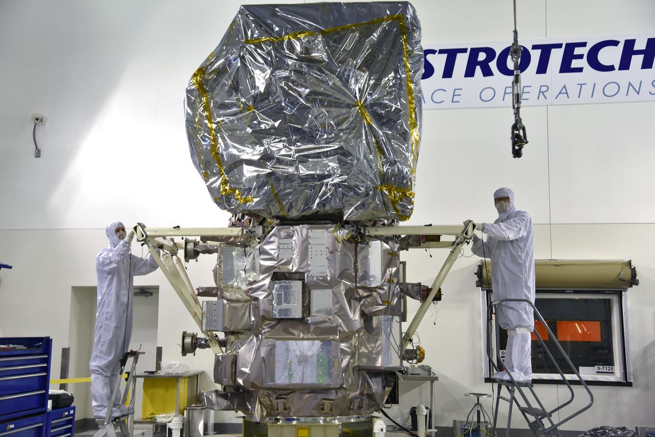
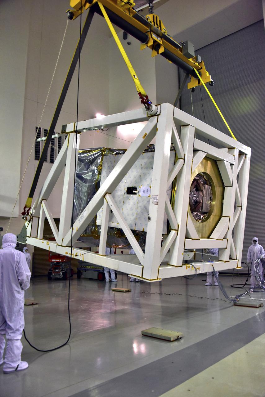
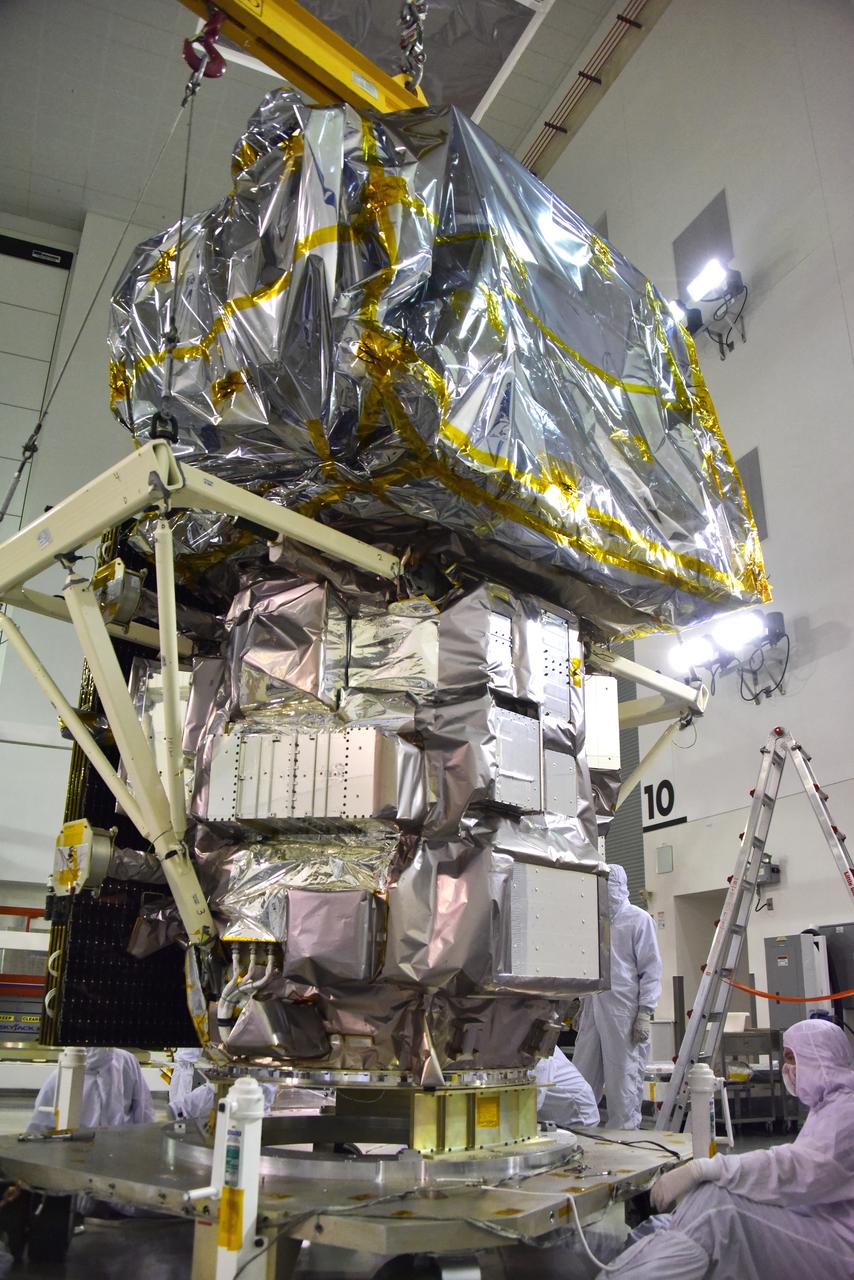
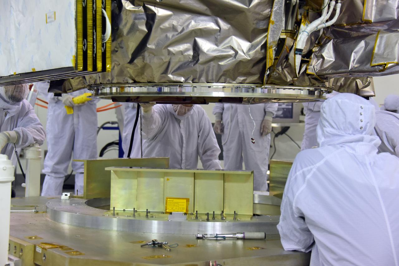
Inside the high bay of the Astrotech Space Operations facility at Vandenberg Air Force Base in California, technicians attach NASA's Ice, Cloud and land Elevation Satellite-2 (ICESat-2) to the payload direct mate adapter, on Aug. 24, 2018. The satellite is being prepared for its scheduled launch from Space Launch Complex 2 at Vandenberg on the final United Launch Alliance Delta II rocket. ICESat-2 will measure the height of a changing Earth, one laser pulse at a time, 10,000 laser pulses a second. The satellite will carry the Advanced Topographic Laser Altimeter System (ATLAS). ICESat-2 will help scientists investigate why, and how much our planet's frozen and icy areas, called the cryosphere, are changing in a warming climate.
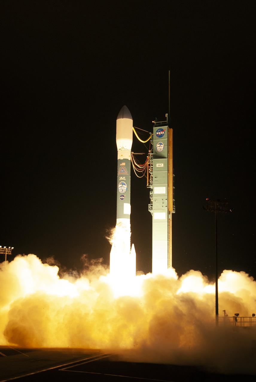
The final United Launch Alliance Delta II rocket lifts off from Space Launch Complex 2 at Vandenberg Air Force Base in California, on Sept. 15, 2018, carrying NASA's Ice, Cloud and land Elevation Satellite-2 (ICESat-2). Liftoff was at 9:02 a.m. EDT (6:02 a.m. PDT). The satellite will measure the height of our changing Earth, one laser pulse at a time, 10,000 laser pulses per second. ICESat-2 will provide scientists with height measurements that create a global portrait of Earth's third dimension, gathering date that can precisely track changes of terrain, including glaciers, sea ice and forests.
Inside the high bay of the Astrotech Space Operations facility at Vandenberg Air Force Base in California, technicians prepare to attach NASA's Ice, Cloud and land Elevation Satellite-2 (ICESat-2) to the payload adapter, on Aug. 20, 2018. The satellite is being prepared for its scheduled launch from Space Launch Complex 2 at Vandenberg on the final United Launch Alliance Delta II rocket. ICESat-2 will measure the height of a changing Earth, one laser pulse at a time, 10,000 laser pulses a second. The satellite will carry the Advanced Topographic Laser Altimeter System (ATLAS). ICESat-2 will help scientists investigate why, and how much our planet's frozen and icy areas, called the cryosphere, are changing in a warming climate.
Technicians assist as a crane rotates NASA's Ice, Cloud and land Elevation Satellite-2 (ICESat-2) into position for removal and lift to a work stand in the high bay of the Astrotech Space Operations facility on June 14, 2018, at Vandenberg Air Force Base in California. ICESat-2 was shipped from the Northrop Grumman facility in Gilbert, Arizona, where it was built and tested. The satellite is scheduled to launch from Space Launch Complex-2 at Vandenberg on the final United Launch Alliance Delta II rocket. ICESat-2 will measure the height of a changing Earth, one laser pulse at a time, 10,000 laser pulses a second. The satellite will carry the Advanced Topographic Laser Altimeter System. ICESat-2 will help scientists investigate why, and how much our planet's frozen and icy areas, called the cryosphere, is changing in a warming climate.
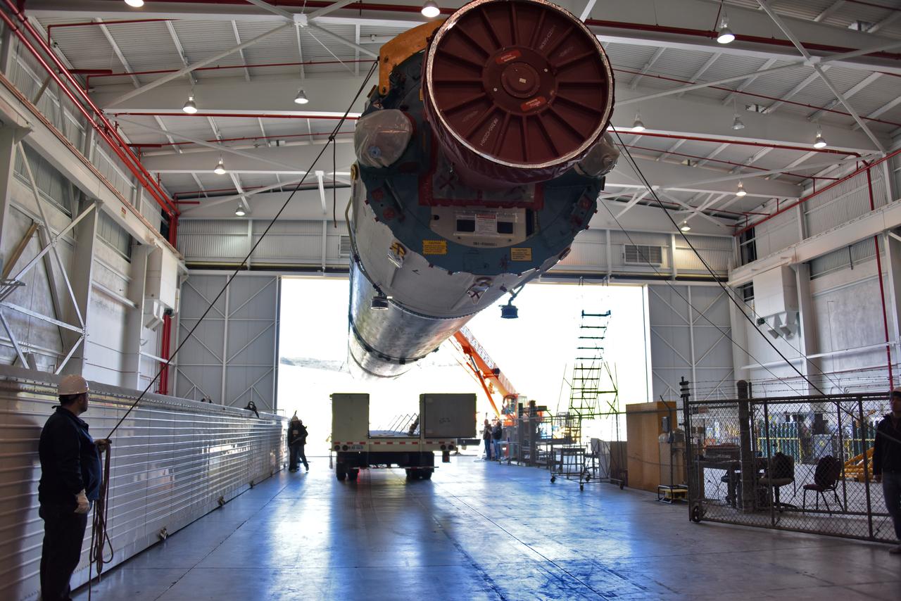
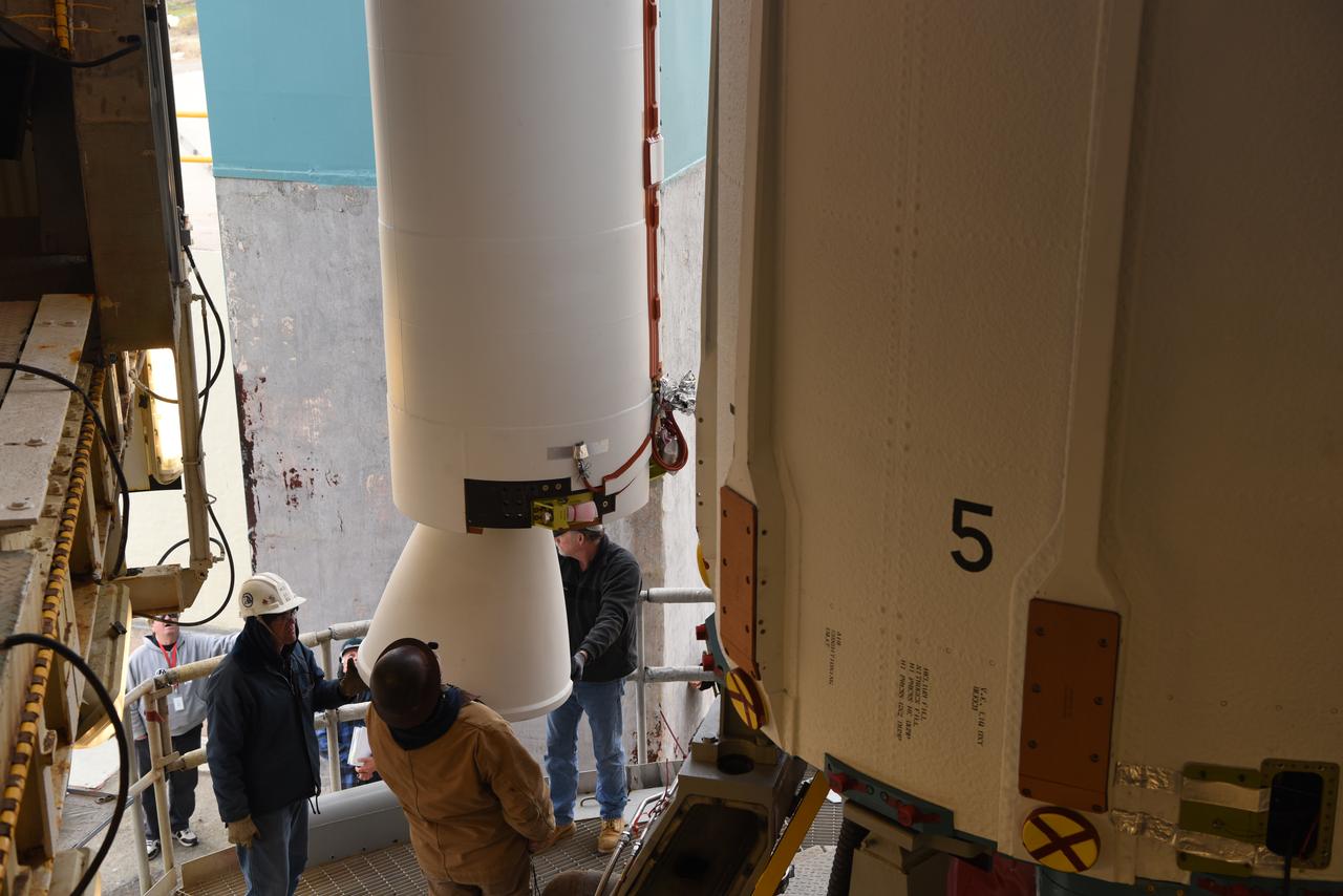
The United Launch Alliance Delta II interstage is lifted up at the Vertical Integration Facility at Space Launch Complex 2 on June 12, 2018, at Vandenberg Air Force Base in California. The interstage will be moved in and mated to the top of the booster, or first stage of the rocket. NASA's Ice, Cloud and land Elevation Satellite-2 (ICESat-2) will launch on the final Delta II rocket. ICESat-2 will measure the height of a changing Earth, one laser pulse at a time, 10,000 laser pulses a second. The satellite will carry a single instrument, the Advanced Topographic Laser Altimeter System. ICESat-2 will help scientists investigate why, and how much our planet's frozen and icy areas, called the cryosphere, is changing in a warming climate.
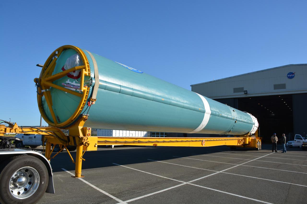
At NASA's Building 836, the Spacecraft Labs Telemetry Station at Vandenberg Air Force Base in California, a United Launch Alliance Delta II booster is removed from its shipping container. After it is offloaded, preliminary checkouts and preflight processing will begin leading to launch of the agency's Ice, Cloud and land Elevation Satellite-2, or ICESat-2. Liftoff from Space Launch Complex-2 at Vandenberg is scheduled for Sept. 12, 2018, and will be the last for the venerable Delta II rocket. Once in orbit, the satellite is designed to measure the height of a changing Earth, one laser pulse at a time, 10,000 laser pulses a second. The satellite will carry a single instrument, the Advanced Topographic Laser Altimeter System. ICESat-2 will help scientists investigate why, and how much, Earth's frozen and icy areas are changing. These area make up Earth's the cryosphere.
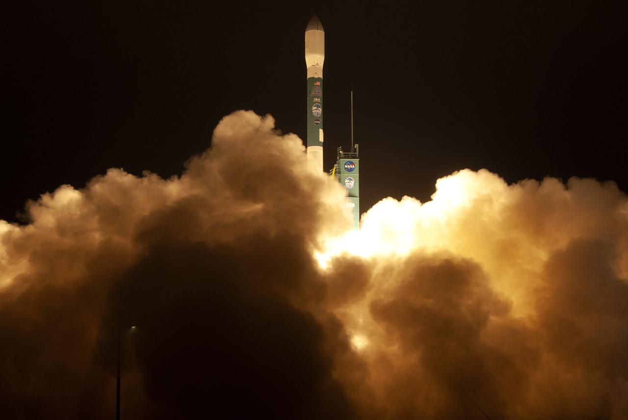
The final United Launch Alliance Delta II rocket lifts off from Space Launch Complex 2 at Vandenberg Air Force Base in California, on Sept. 15, 2018, carrying NASA's Ice, Cloud and land Elevation Satellite-2 (ICESat-2). Liftoff was at 9:02 a.m. EDT (6:02 a.m. PDT). The satellite will measure the height of our changing Earth, one laser pulse at a time, 10,000 laser pulses per second. ICESat-2 will provide scientists with height measurements that create a global portrait of Earth's third dimension, gathering date that can precisely track changes of terrain, including glaciers, sea ice and forests.
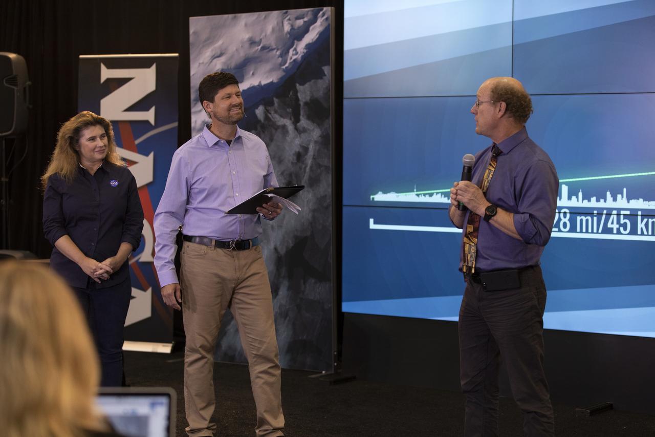
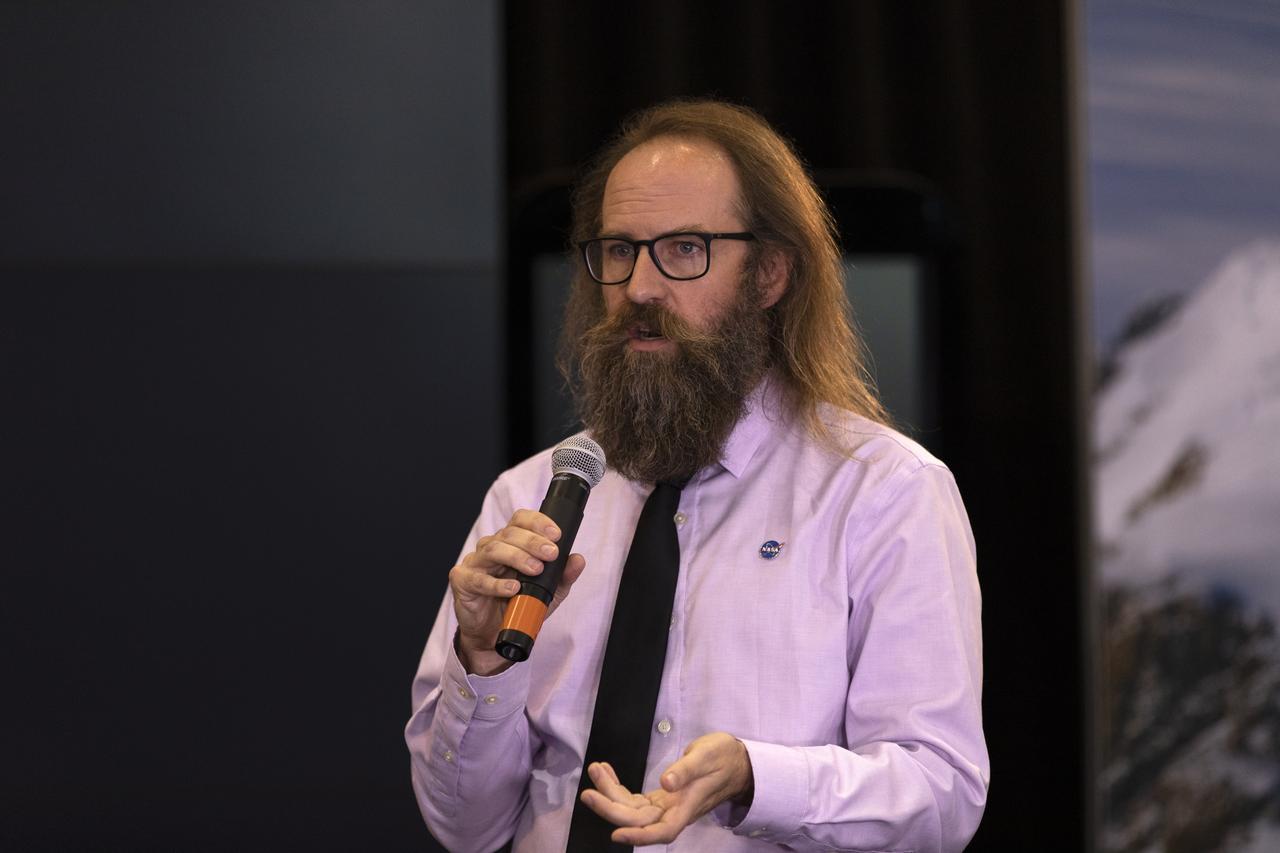
Doug McLennan, ICESat-2 project manager, NASA’s Goddard Space Flight Center, speaks to members of the news media and social media participants during a prelaunch mission briefing for NASA's Ice, Cloud and land Elevation Satellite-2 (ICESat-2), a mission to measure the changing height of Earth's ice, on Sept. 13, 2018 at Vandenberg Air Force Base (VAFB) in California. ICESat-2 will launch aboard a United Launch Alliance Delta II, the rocket’s final mission, from Space Launch Complex 2 at VAFB. Launch is scheduled for 8:46 a.m. EDT (5:46 a.m. PDT).
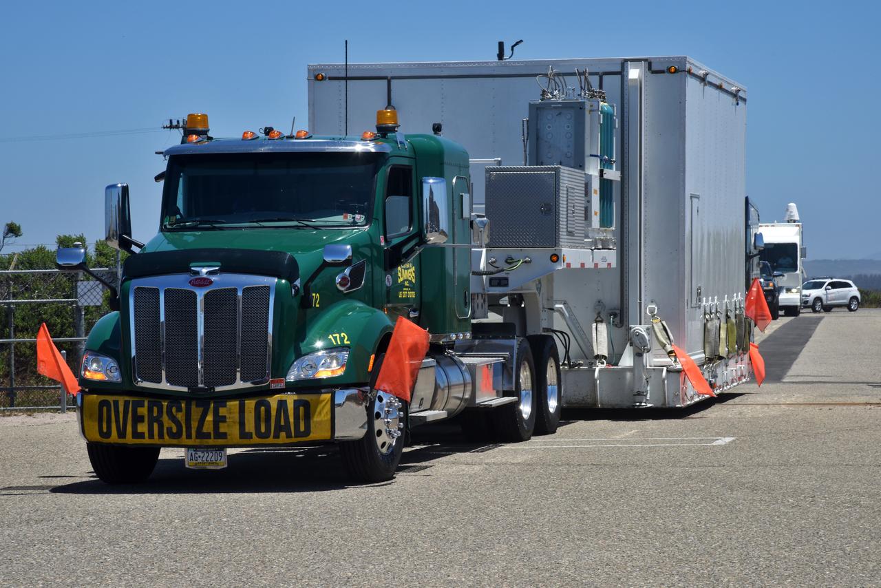
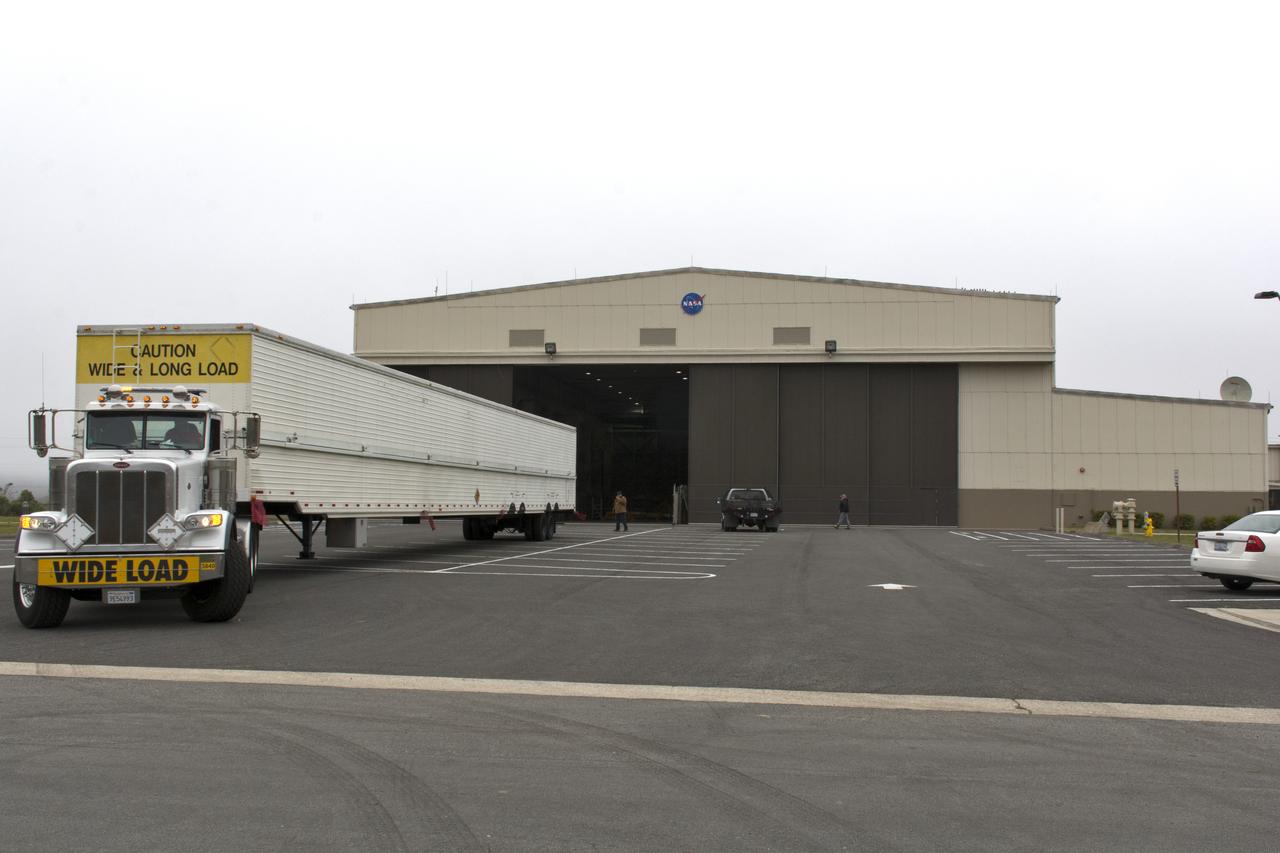
NASA's Ice, Cloud and land Elevation Satellite-2 (ICESat-2) arrives in its shipping container aboard a heavy transport truck on June 12, 2018, at Vandenberg Air Force Base in California. ICESat-2 was shipped from the Northrop Grumman facility in Gilbert, Arizona, where it was built and tested. The satellite is scheduled to launch Sept. 12, 2018, on the final United Launch Alliance Delta II rocket from Space Launch Complex-2 at Vandenberg. ICESat-2 will measure the height of a changing Earth, one laser pulse at a time, 10,000 laser pulses a second. The satellite will carry the Advanced Topographic Laser Altimeter System. ICESat-2 will help scientists investigate why, and how much our planet's frozen and icy areas, called the cryosphere, is changing in a warming climate.
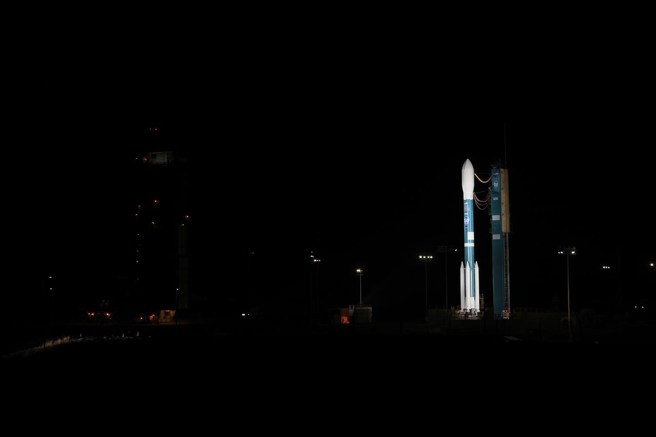
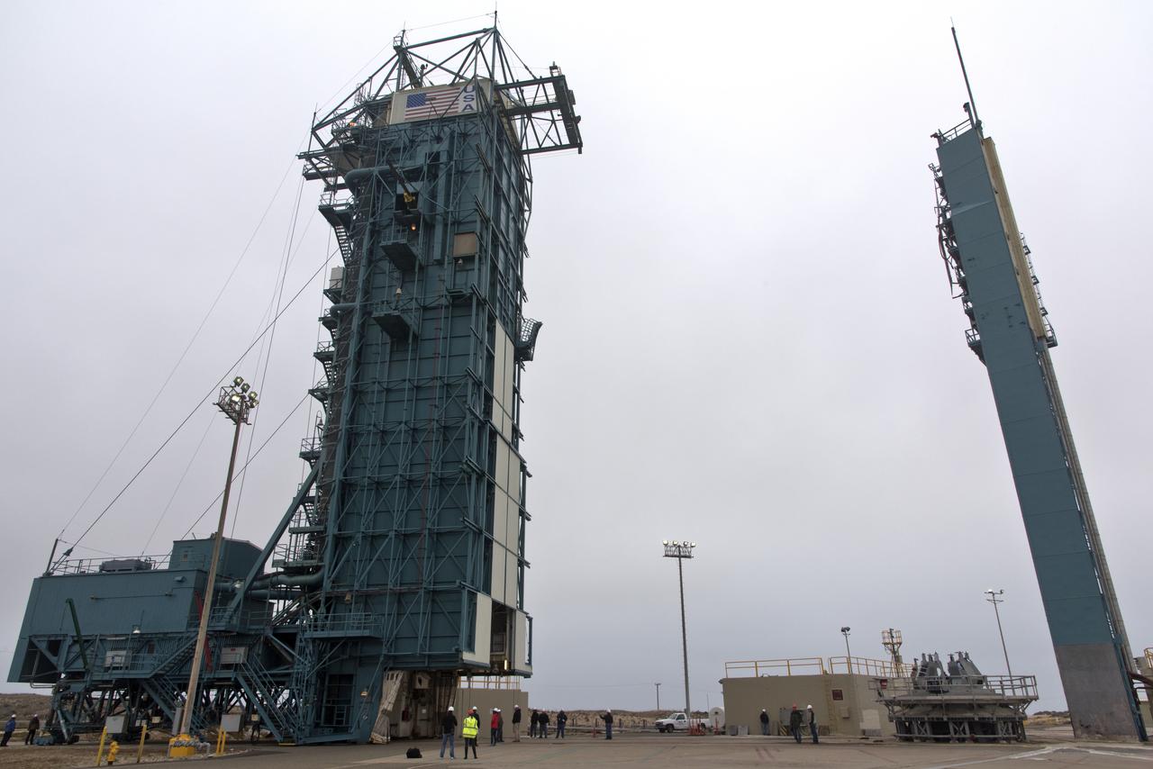
The gantry rolls back at Space Launch Complex 2 at Vandenberg Air Force Base in California, on Sept. 14, 2018, for the final United Launch Alliance Delta II rocket which will carry NASA's Ice, Cloud and land Elevation Satellite-2 (ICESat-2). Liftoff is scheduled for Sept. 15, 2018, at 8:46 a.m. EDT (5:46 a.m. PDT). The satellite will measure the height of our changing Earth, one laser pulse at a time, 10,000 laser pulses per second. ICESat-2 will provide scientists with height measurements that create a global portrait of Earth's third dimension, gathering date that can precisely track changes of terrain, including glaciers, sea ice and forests.
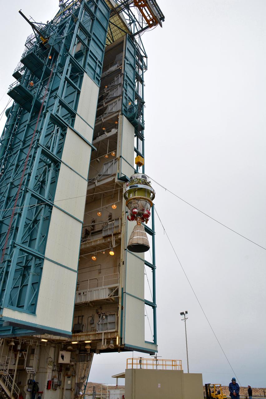
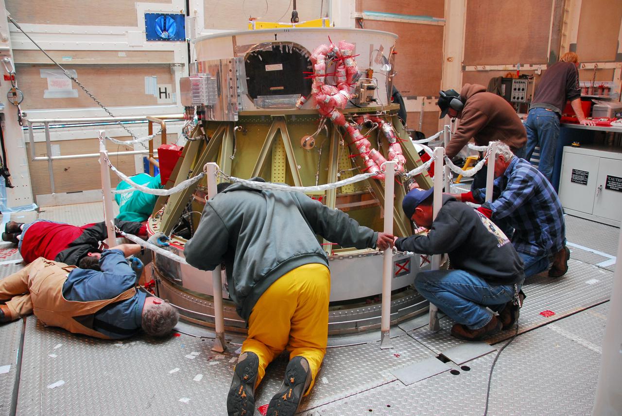
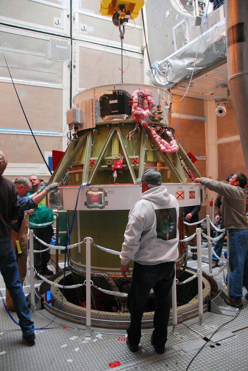
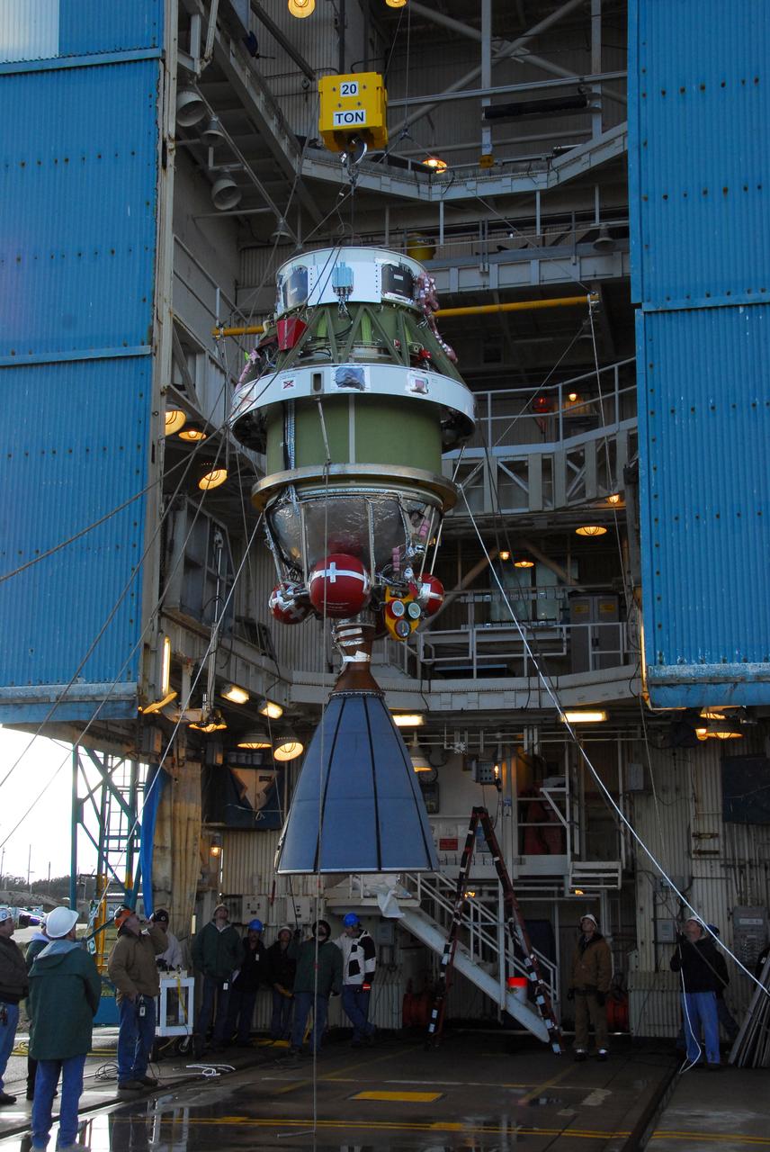
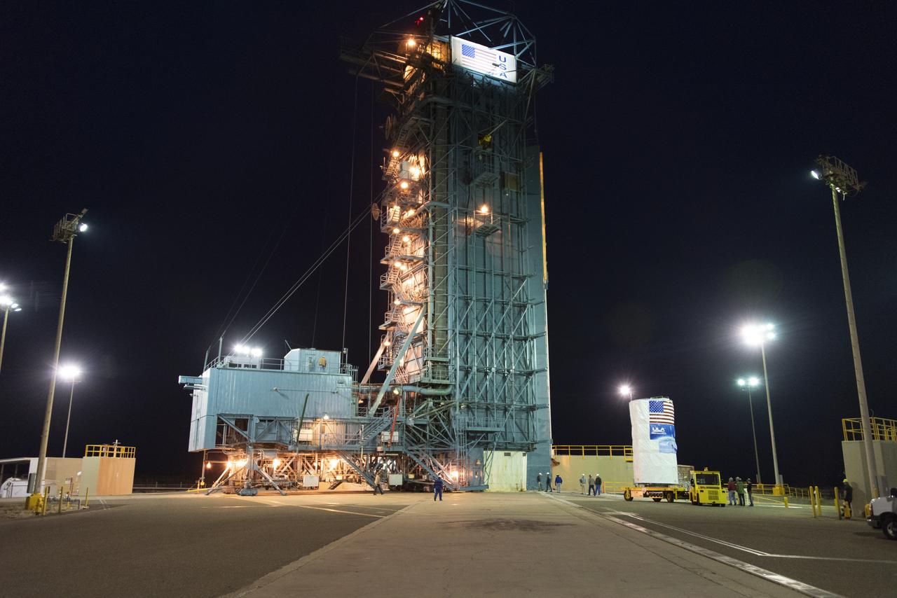
The United Launch Alliance Delta II second stage is lifted high up at the Vertical Integration Facility at Space Launch Complex 2 on June 12, 2018, at Vandenberg Air Force Base in California. The second stage will be attached to the top of the booster, or first stage of the rocket. NASA's Ice, Cloud and land Elevation Satellite-2 (ICESat-2) will launch on the final Delta II rocket. ICESat-2 will measure the height of a changing Earth, one laser pulse at a time, 10,000 laser pulses a second. The satellite will carry a single instrument, the Advanced Topographic Laser Altimeter System. ICESat-2 will help scientists investigate why, and how much our planet's frozen and icy areas, called the cryosphere, is changing in a warming climate.
Inside the Astrotech Space Operations high bay at Vandenberg Air Force Base in California, technicians prepare NASA's Ice, Cloud and land Elevation Satellite-2 (ICESat-2), for installation of the protective canister on Aug. 25, 2018. The satellite will be transported to Space Launch Complex 2 where it will be hoisted up by crane and attached to the United Launch Alliance Delta II rocket. Launch is scheduled for Sept. 15, 2018. ICESat-2 will measure the height of a changing Earth, one laser pulse at a time, 10,000 laser pulses a second. The satellite will carry the Advanced Topographic Laser Altimeter System (ATLAS). ICESat-2 will help scientists investigate why, and how much our planet's frozen and icy areas, called the cryosphere, are changing in a warming climate.
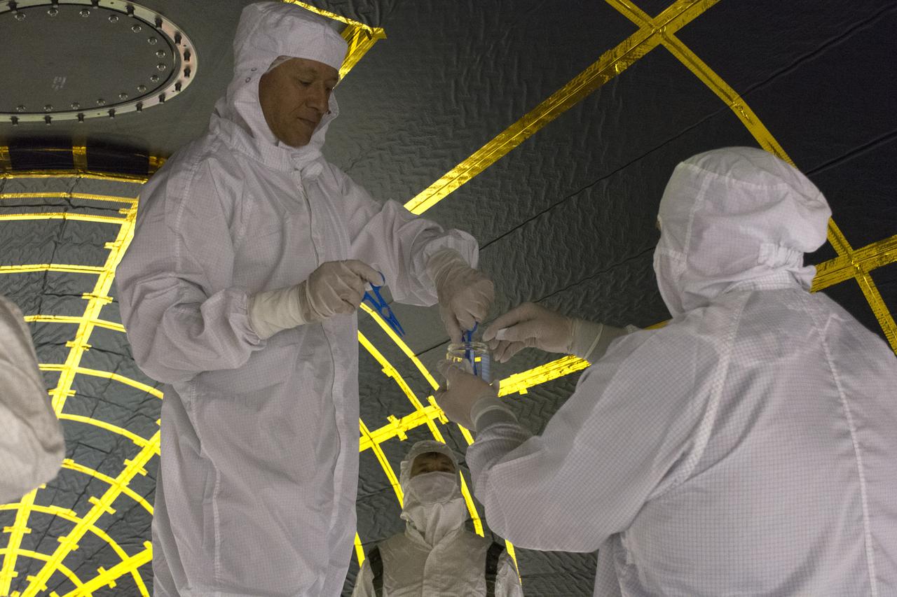
On Friday, April 6, 2018, in NASA’s Building 8337 at Vandenberg Air Force Base in California, technicians and engineers clean and take samples from the payload fairing the will protect NASA's Ice, Cloud and land Elevation Satellite-2, or ICESat-2, satellite during launch. Liftoff atop a United Launch Alliance Delta II rocket is scheduled for Sept. 12, 2018, from Space Launch Complex-2 at Vandenberg. It will be the last for the venerable Delta II rocket. ICESat-2, which is being built and tested by Orbital ATK in Gilbert, Arizona, will carry a single instrument called the Advanced Topographic Laser Altimeter System, or ATLAS. The ATLAS instrument is being built and tested at NASA’s Goddard Space Flight Center in Greenbelt Maryland. Once in orbit, the satellite is designed to measure the height of a changing Earth, one laser pulse at a time, 10,000 laser pulses a second. ICESat-2 will help scientists investigate why, and how much, Earth’s frozen and icy areas, called the cryosphere, are changing.
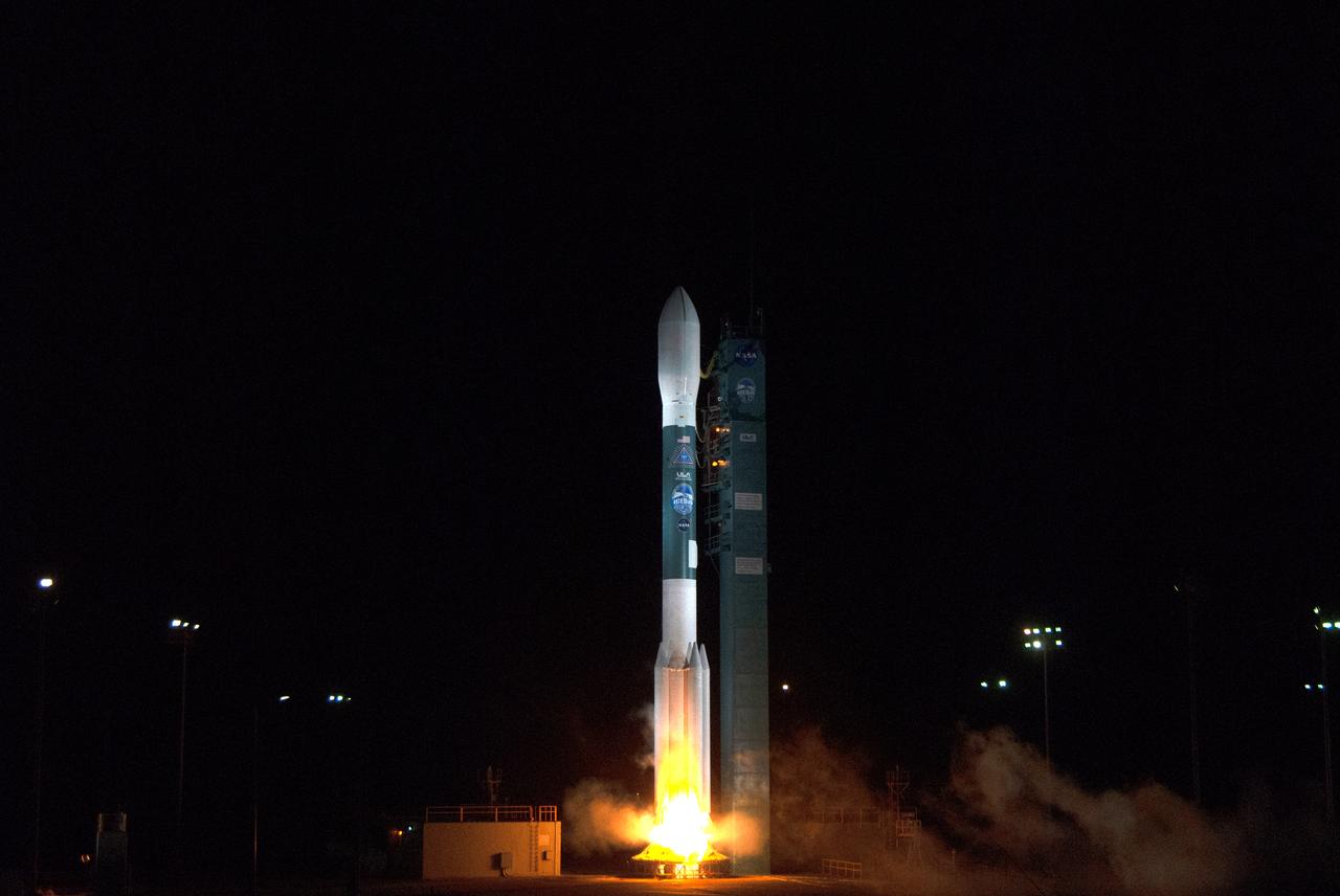
The final United Launch Alliance Delta II rocket lifts off from Space Launch Complex 2 at Vandenberg Air Force Base in California, on Sept. 15, 2018, carrying NASA's Ice, Cloud and land Elevation Satellite-2 (ICESat-2). Liftoff was at 9:02 a.m. EDT (6:02 a.m. PDT). The satellite will measure the height of our changing Earth, one laser pulse at a time, 10,000 laser pulses per second. ICESat-2 will provide scientists with height measurements that create a global portrait of Earth's third dimension, gathering date that can precisely track changes of terrain, including glaciers, sea ice and forests.
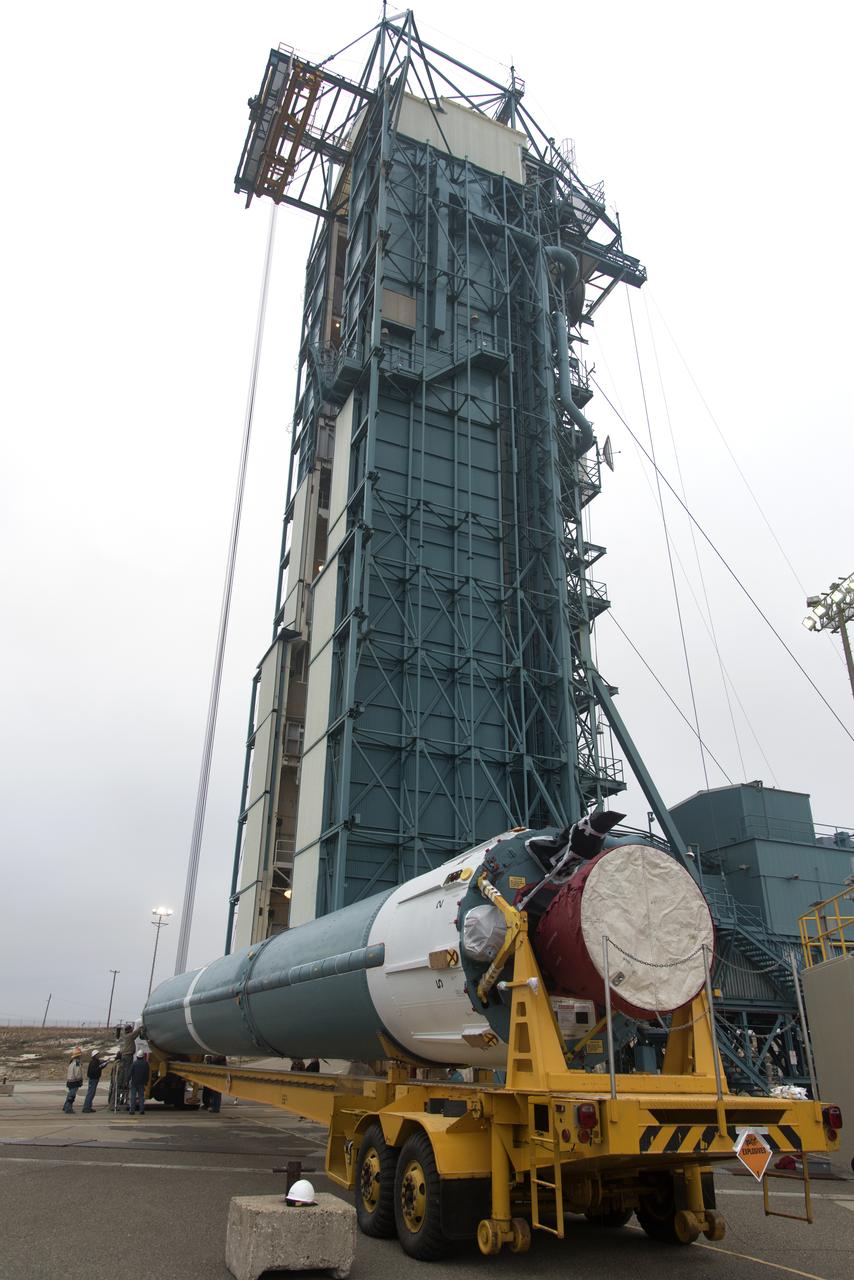
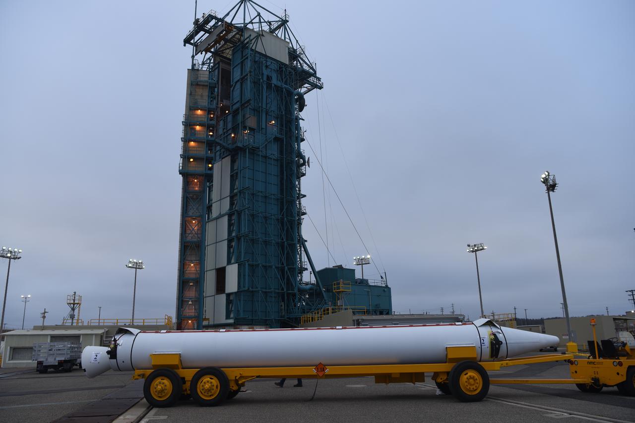
At Vandenberg Air Force Base in California, on Tuesday, April 17, 2018, a United Launch Alliance (ULA) Delta II booster is transported to Space Launch Complex-2 where it will launch NASA's Ice, Cloud and land Elevation Satellite-2, or ICESat-2, satellite. This will be the last flight for the venerable Delta II rocket. ICESat-2, which is being built and tested by Orbital ATK in Gilbert, Arizona, will carry a single instrument called the Advanced Topographic Laser Altimeter System, or ATLAS. The ATLAS instrument is being built and tested at NASA’s Goddard Space Flight Center in Greenbelt Maryland. Once in orbit, the satellite is designed to measure the height of a changing Earth, one laser pulse at a time, 10,000 laser pulses a second. ICESat-2 will help scientists investigate why, and how much, Earth’s frozen and icy areas, called the cryosphere, are changing.
NASA's Ice, Cloud and land Elevation Satellite-2 (ICESat-2) is moved into the high bay of the Astrotech processing facility on June 13, 2018, at Vandenberg Air Force Base in California. ICESat-2 was shipped from the Northrop Grumman facility in Gilbert, Arizona, where it was built and tested. The satellite is scheduled to launch from Space Launch Complex-2 at Vandenberg on the final United Launch Alliance Delta II rocket. ICESat-2 will measure the height of a changing Earth, one laser pulse at a time, 10,000 laser pulses a second. The satellite will carry the Advanced Topographic Laser Altimeter System. ICESat-2 will help scientists investigate why, and how much our planet's frozen and icy areas, called the cryosphere, is changing in a warming climate.
Technicians assist as the second half of the United Launch Alliance (ULA) Delta II rocket payload fairing is lifted up into the Vertical Integration Facility at Space Launch Complex 2 at Vandenberg Air Force Base in California, on June 4, 2018. NASA's Ice, Cloud and land Elevation Satellite-2 (ICESat-2) will launch later this year on the final Delta II rocket. ICESat-2 will measure the height of a changing Earth, one laser pulse at a time, 10,000 laser pulses a second. The satellite will carry a single instrument, the Advanced Topographic Laser Altimeter System. ICESat-2 will help scientists investigate why, and how much our planet's frozen and icy areas, called the cryosphere, is changing in a warming climate.
The United Launch Alliance Delta II first stage is lifted to vertical on the stand at Space Launch Complex 2 on June 8, 2018, at Vandenberg Air Force Base in California. The booster will be lifted and moved into the mobile service tower. NASA's Ice, Cloud and land Elevation Satellite-2 (ICESat-2) will launch on the final Delta II rocket. ICESat-2 will measure the height of a changing Earth, one laser pulse at a time, 10,000 laser pulses a second. The satellite will carry a single instrument, the Advanced Topographic Laser Altimeter System. ICESat-2 will help scientists investigate why, and how much our planet's frozen and icy areas, called the cryosphere, is changing in a warming climate.
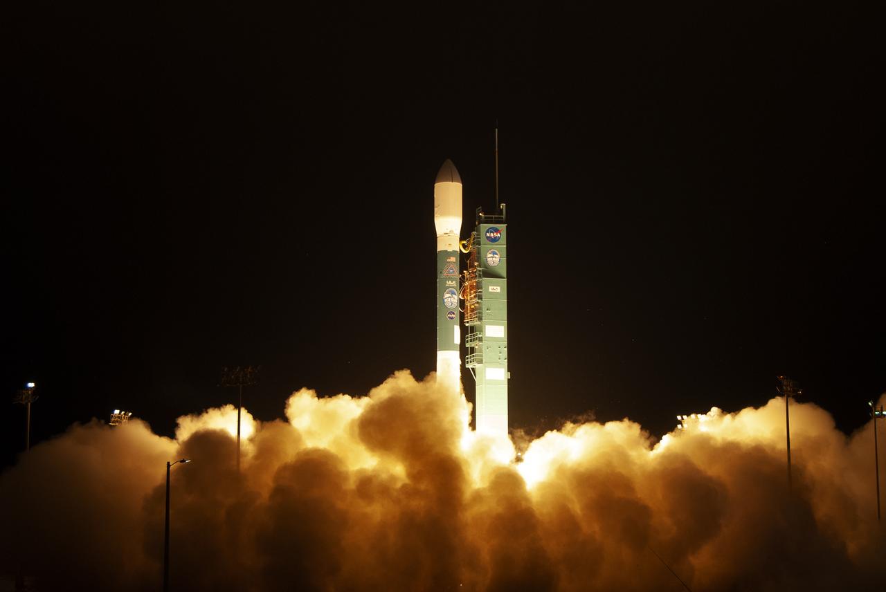
The final United Launch Alliance Delta II rocket lifts off from Space Launch Complex 2 at Vandenberg Air Force Base in California, on Sept. 15, 2018, carrying NASA's Ice, Cloud and land Elevation Satellite-2 (ICESat-2). Liftoff was at 9:02 a.m. EDT (6:02 a.m. PDT). The satellite will measure the height of our changing Earth, one laser pulse at a time, 10,000 laser pulses per second. ICESat-2 will provide scientists with height measurements that create a global portrait of Earth's third dimension, gathering date that can precisely track changes of terrain, including glaciers, sea ice and forests.
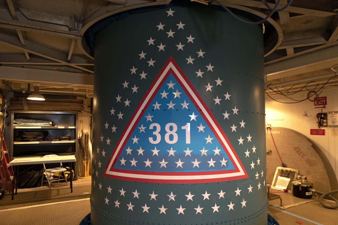
Stars are in view on the first stage of the United Launch Alliance Delta II rocket at Space Launch Complex 2 at Vandenberg Air Force Base in California, on Sept. 13, 2018. Historically, each Delta rocket used to notate the number of launches within the program, beginning in May, 1960, with the first Delta I. This practice was brought back for the final Delta II launch of ICESat-2. The “381” on the rocket signifies that this will be the 381st flight in the Delta family. A star traditionally was placed on the rocket to recognize each mission. For the final Delta II, stars were sent to team members and partners throughout the nation. This rocket boasts more than 150 stars with over 800 signatures of people who have been part of the Delta II program.

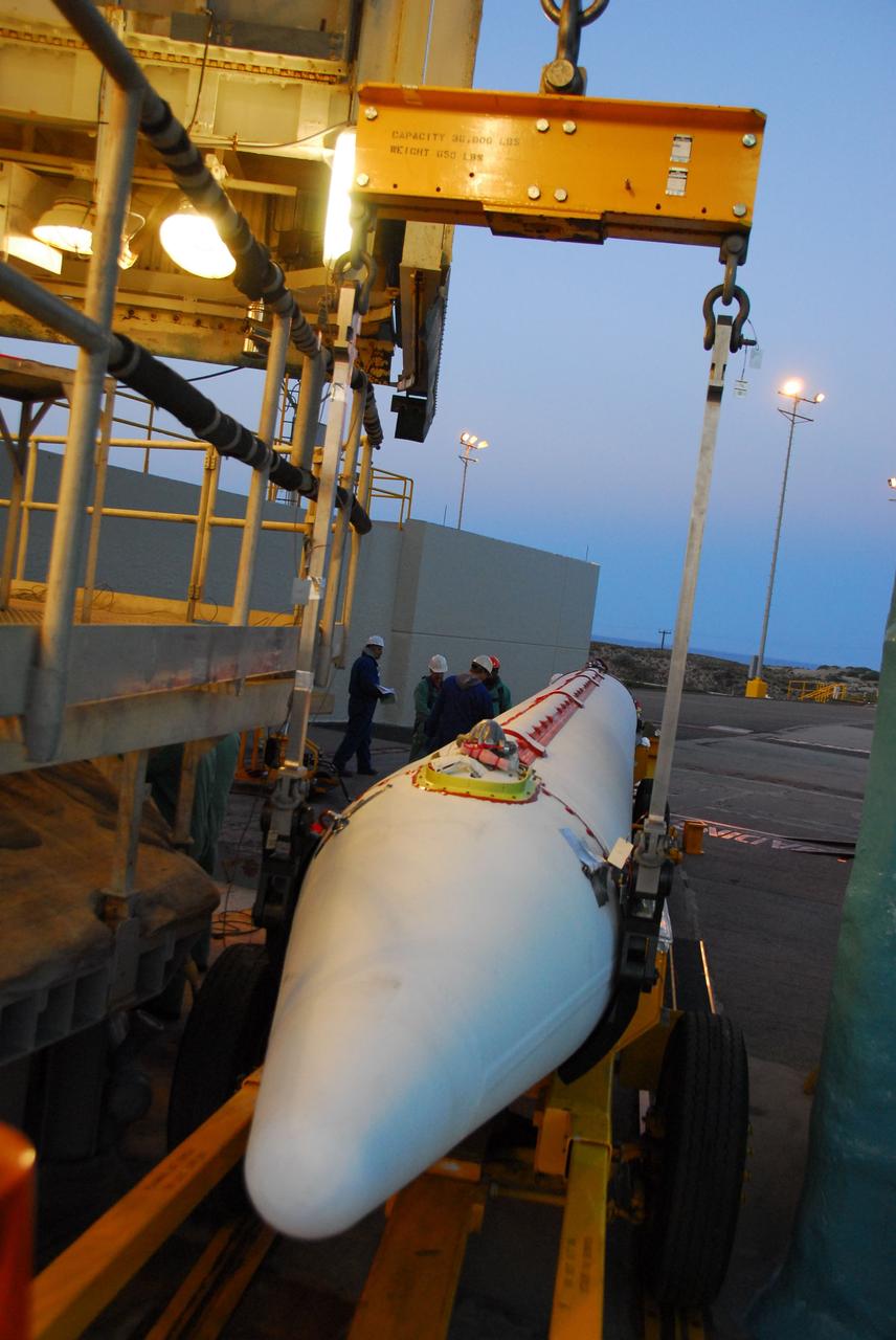
At Vandenberg Air Force Base in California, NASA's Ice, Cloud and land Elevation Satellite-2 (ICESat-2) is hoisted up by crane at the mobile service tower at Space Launch Complex 2, on Aug. 26, 2018. The satellite will be attached to the top of the United Launch Alliance Delta II rocket. Launch is scheduled for Sept. 15, 2018. ICESat-2 will measure the height of a changing Earth, one laser pulse at a time, 10,000 laser pulses a second. The satellite will carry the Advanced Topographic Laser Altimeter System (ATLAS). ICESat-2 will help scientists investigate why, and how much our planet's frozen and icy areas, called the cryosphere, are changing in a warming climate.

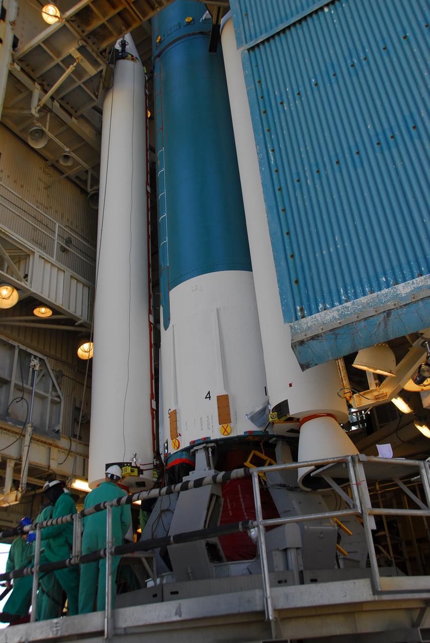
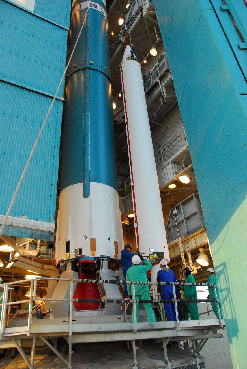
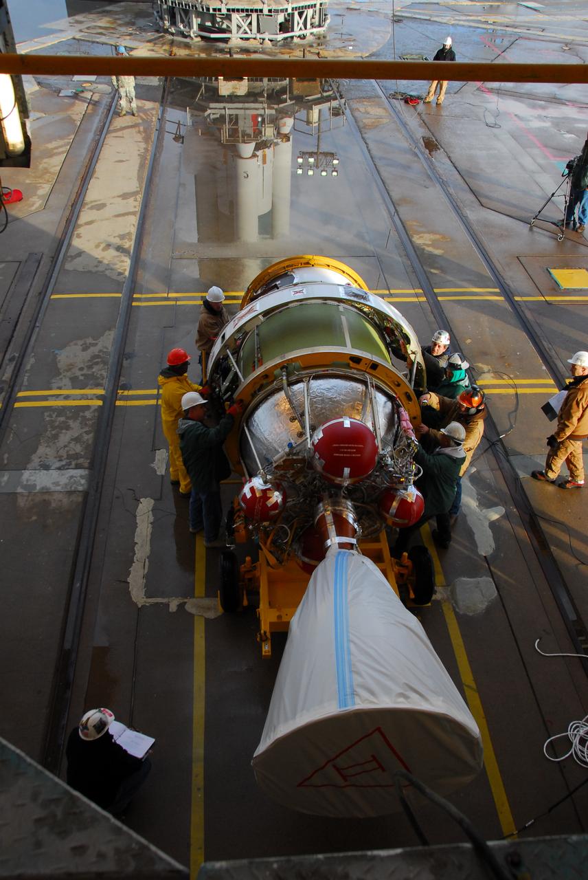
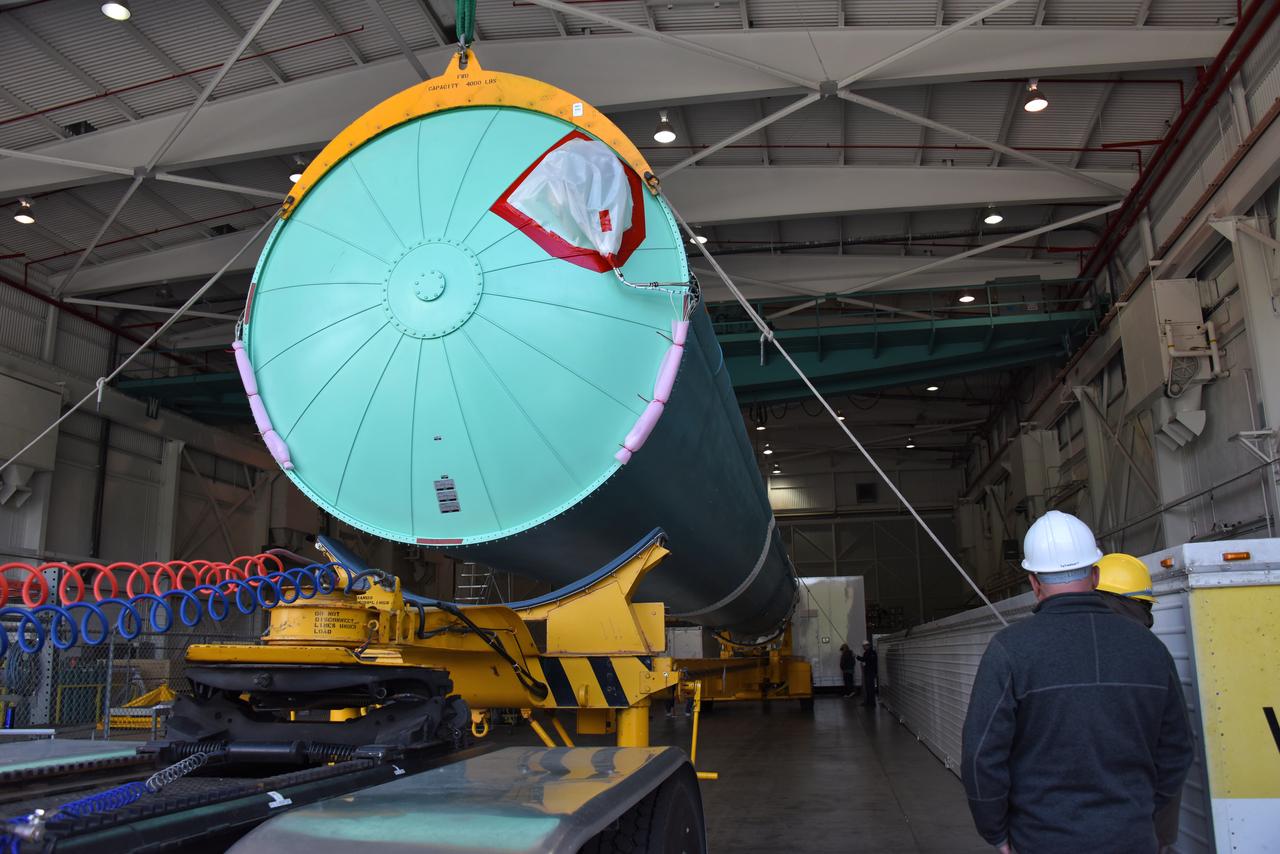
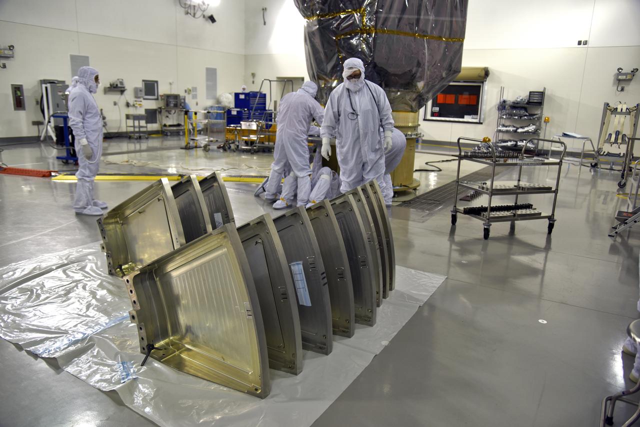
The solid rocket motor for mating to the United Launch Alliance Delta II launch vehicle is lifted up at the Vertical Integration Facility (VIF) at Space Launch Complex 2 on June 14, 2018, at Vandenberg Air Force Base in California. The solid rocket motor will be attached to the rocket. NASA's Ice, Cloud and land Elevation Satellite-2 (ICESat-2) will launch on the final Delta II rocket. ICESat-2 will measure the height of a changing Earth, one laser pulse at a time, 10,000 laser pulses a second. The satellite will carry a single instrument, the Advanced Topographic Laser Altimeter System. ICESat-2 will help scientists investigate why, and how much our planet's frozen and icy areas, called the cryosphere, is changing in a warming climate.
A United Launch Alliance Delta II booster arrives at NASA's Building 836, the Spacecraft Labs Telemetry Station at Vandenberg Air Force Base in California. It will be offloaded and begin preliminary checkouts and preflight processing for launch of the agency's Ice, Cloud and land Elevation Satellite-2, or ICESat-2. Liftoff from Space Launch Complex-2 at Vandenberg is scheduled for Sept. 12, 2018, and will be the last for the venerable Delta II rocket. Once in orbit, the satellite is designed to measure the height of a changing Earth, one laser pulse at a time, 10,000 laser pulses a second. The satellite will carry a single instrument, the Advanced Topographic Laser Altimeter System. ICESat-2 will help scientists investigate why, and how much, Earth's frozen and icy areas are changing. These area make up Earth's the cryosphere.
The first half of the United Launch Alliance (ULA) Delta II rocket payload fairing is lifted up and into the Vertical Integration Facility at Space Launch Complex 2 at Vandenberg Air Force Base in California, on June 4, 2018. NASA's Ice, Cloud and land Elevation Satellite-2 (ICESat-2) will launch later this year on the final Delta II rocket. ICESat-2 will measure the height of a changing Earth, one laser pulse at a time, 10,000 laser pulses a second. The satellite will carry a single instrument, the Advanced Topographic Laser Altimeter System. ICESat-2 will help scientists investigate why, and how much our planet's frozen and icy areas, called the cryosphere, is changing in a warming climate.
Inside the Astrotech Space Operations high bay at Vandenberg Air Force Base in California, technicians prepare the canister, at right, for installation around NASA's Ice, Cloud and land Elevation Satellite-2 (ICESat-2), at left, on Aug. 25, 2018. The satellite will be transported to Space Launch Complex 2 where it will be hoisted up by crane and attached to the United Launch Alliance Delta II rocket. Launch is scheduled for Sept. 15, 2018. ICESat-2 will measure the height of a changing Earth, one laser pulse at a time, 10,000 laser pulses a second. The satellite will carry the Advanced Topographic Laser Altimeter System (ATLAS). ICESat-2 will help scientists investigate why, and how much our planet's frozen and icy areas, called the cryosphere, are changing in a warming climate.
At NASA's Building 836, the Spacecraft Labs Telemetry Station at Vandenberg Air Force Base in California, a United Launch Alliance Delta II booster has been removed from its shipping container. Preliminary checkouts and preflight processing will begin leading to launch of the agency's Ice, Cloud and land Elevation Satellite-2, or ICESat-2. Liftoff from Space Launch Complex-2 at Vandenberg is scheduled for Sept. 12, 2018, and will be the last for the venerable Delta II rocket. Once in orbit, the satellite is designed to measure the height of a changing Earth, one laser pulse at a time, 10,000 laser pulses a second. The satellite will carry a single instrument, the Advanced Topographic Laser Altimeter System. ICESat-2 will help scientists investigate why, and how much, Earth's frozen and icy areas are changing. These area make up Earth's the cryosphere.

Social media participant sketches NASA and industry leaders speaking to members of the news media and social media participants during a prelaunch mission briefing for NASA's Ice, Cloud and land Elevation Satellite-2 (ICESat-2) on Sept. 13, 2018, at Vandenberg Air Force Base (VAFB) in California. ICESat-2 will launch aboard a United Launch Alliance Delta II, the rocket’s final mission, from Space Launch Complex 2 at VAFB. Launch is scheduled for 8:46 a.m. EDT (5:46 a.m. PDT). The satellite will measure the height of our changing Earth, one laser pulse at a time, 10,000 laser pulses per second. ICESat-2 will provide scientists with height measurements that create a global portrait of Earth's third dimension, gathering date that can precisely track changes of terrain, including glaciers, sea ice and forests.
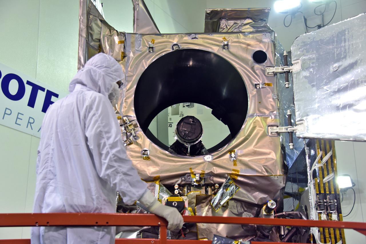
Inside the high bay of the Astrotech Space Operations facility at Vandenberg Air Force Base in California, a technician opens and checks the flight door for the Advanced Topographic Laser Altimeter System (ATLAS) on NASA's Ice, Cloud and land Elevation Satellite-2 (ICESat-2) on June 21, 2018. The satellite is being prepared for its scheduled launch from Space Launch Complex-2 at Vandenberg on the final United Launch Alliance Delta II rocket. ICESat-2 will measure the height of a changing Earth, one laser pulse at a time, 10,000 laser pulses a second. The satellite will carry ATLAS. ICESat-2 will help scientists investigate why, and how much our planet's frozen and icy areas, called the cryosphere, is changing in a warming climate.
United Launch Alliance (ULA) technicians assist as the solid rocket motor is lifted up and moved toward the Delta II launch vehicle in the Vertical Integration Facility (VIF) at Space Launch Complex 2 on June 14, 2018, at Vandenberg Air Force Base in California. The solid rocket motor will be attached to the rocket. NASA's Ice, Cloud and land Elevation Satellite-2 (ICESat-2) will launch on the final ULA Delta II rocket. ICESat-2 will measure the height of a changing Earth, one laser pulse at a time, 10,000 laser pulses a second. The satellite will carry a single instrument, the Advanced Topographic Laser Altimeter System. ICESat-2 will help scientists investigate why, and how much our planet's frozen and icy areas, called the cryosphere, is changing in a warming climate.
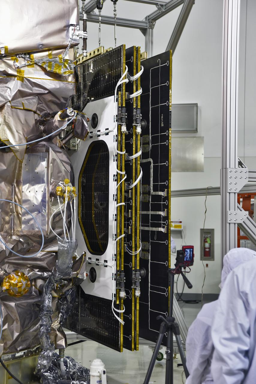
Inside the high bay of the Astrotech Space Operations facility at Vandenberg Air Force Base in California, a solar array first motion test is underway on NASA's Ice, Cloud and land Elevation Satellite-2 (ICESat-2) on June 18, 2018. The satellite is being prepared for its scheduled launch from Space Launch Complex-2 at Vandenberg on the final United Launch Alliance Delta II rocket. ICESat-2 will measure the height of a changing Earth, one laser pulse at a time, 10,000 laser pulses a second. The satellite will carry the Advanced Topographic Laser Altimeter System. ICESat-2 will help scientists investigate why, and how much our planet's frozen and icy areas, called the cryosphere, is changing in a warming climate.
At NASA's Building 836, the Spacecraft Labs Telemetry Station at Vandenberg Air Force Base in California, on Tuesday, April 17, 2018, a United Launch Alliance (ULA) Delta II booster is transported to Space Launch Complex-2 where it will launch NASA's Ice, Cloud and land Elevation Satellite-2, or ICESat-2, satellite. This will be the last flight for the venerable Delta II rocket. ICESat-2, which is being built and tested by Orbital ATK in Gilbert, Arizona, will carry a single instrument called the Advanced Topographic Laser Altimeter System, or ATLAS. The ATLAS instrument is being built and tested at NASA’s Goddard Space Flight Center in Greenbelt Maryland. Once in orbit, the satellite is designed to measure the height of a changing Earth, one laser pulse at a time, 10,000 laser pulses a second. ICESat-2 will help scientists investigate why, and how much, Earth’s frozen and icy areas, called the cryosphere, are changing.
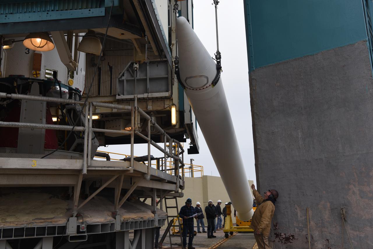
The solid rocket motor for mating to the United Launch Alliance Delta II launch vehicle is lifted up at the Vertical Integration Facility (VIF) at Space Launch Complex 2 on June 14, 2018, at Vandenberg Air Force Base in California. The solid rocket motor will be attached to the rocket. NASA's Ice, Cloud and land Elevation Satellite-2 (ICESat-2) will launch on the final Delta II rocket. ICESat-2 will measure the height of a changing Earth, one laser pulse at a time, 10,000 laser pulses a second. The satellite will carry a single instrument, the Advanced Topographic Laser Altimeter System. ICESat-2 will help scientists investigate why, and how much our planet's frozen and icy areas, called the cryosphere, is changing in a warming climate.
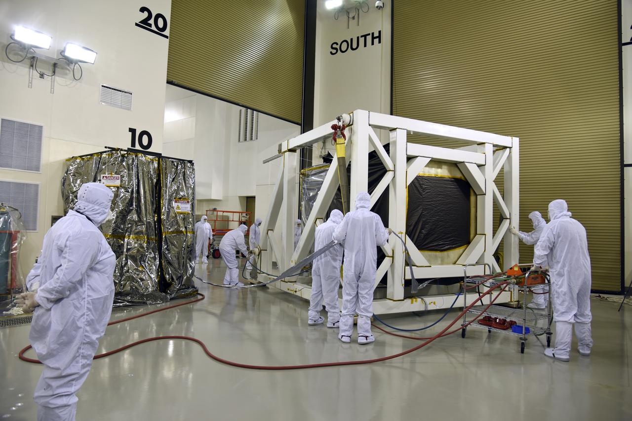
Inside the high bay of the Astrotech Space Operations facility at Vandenberg Air Force Base in California, technicians assist as a crane lowers NASA's Ice, Cloud and land Elevation Satellite-2 (ICESat-2) onto the payload adapter on Aug. 30, 2018. ICESat-2 is being prepared for its scheduled launch from Space Launch Complex 2 at Vandenberg on the final United Launch Alliance Delta II rocket. ICESat-2 will measure the height of a changing Earth, one laser pulse at a time, 10,000 laser pulses a second. The satellite will carry the Advanced Topographic Laser Altimeter System (ATLAS). ICESat-2 will help scientists investigate why, and how much our planet's frozen and icy areas, called the cryosphere, are changing in a warming climate.
At NASA's Building 836, the Spacecraft Labs Telemetry Station at Vandenberg Air Force Base in California, a United Launch Alliance Delta II booster is removed from its shipping container. After it is offloaded, preliminary checkouts and preflight processing will begin leading to launch of the agency's Ice, Cloud and land Elevation Satellite-2, or ICESat-2. Liftoff from Space Launch Complex-2 at Vandenberg is scheduled for Sept. 12, 2018, and will be the last for the venerable Delta II rocket. Once in orbit, the satellite is designed to measure the height of a changing Earth, one laser pulse at a time, 10,000 laser pulses a second. The satellite will carry a single instrument, the Advanced Topographic Laser Altimeter System. ICESat-2 will help scientists investigate why, and how much, Earth's frozen and icy areas are changing. These area make up Earth's the cryosphere.
The gantry rolls back at Space Launch Complex 2 at Vandenberg Air Force Base in California, on Sept. 14, 2018, for the final United Launch Alliance Delta II rocket which will carry NASA's Ice, Cloud and land Elevation Satellite-2 (ICESat-2). Liftoff is scheduled for Sept. 15, 2018, at 8:46 a.m. EDT (5:46 a.m. PDT). The satellite will measure the height of our changing Earth, one laser pulse at a time, 10,000 laser pulses per second. ICESat-2 will provide scientists with height measurements that create a global portrait of Earth's third dimension, gathering date that can precisely track changes of terrain, including glaciers, sea ice and forests.
Inside the high bay of the Astrotech Space Operations facility at Vandenberg Air Force Base in California, a solar array first motion test is in progress on NASA's Ice, Cloud and land Elevation Satellite-2 (ICESat-2) on June 18, 2018. The satellite is being prepared for its scheduled launch from Space Launch Complex-2 at Vandenberg on the final United Launch Alliance Delta II rocket. ICESat-2 will measure the height of a changing Earth, one laser pulse at a time, 10,000 laser pulses a second. The satellite will carry the Advanced Topographic Laser Altimeter System. ICESat-2 will help scientists investigate why, and how much our planet's frozen and icy areas, called the cryosphere, is changing in a warming climate.
United Launch Alliance (ULA) workers assist as the Delta II first stage is lifted to vertical at Space Launch Complex 2 on June 8, 2018, at Vandenberg Air Force Base in California. The booster will be moved into the mobile service tower. NASA's Ice, Cloud and land Elevation Satellite-2 (ICESat-2) will launch on the final Delta II rocket. ICESat-2 will measure the height of a changing Earth, one laser pulse at a time, 10,000 laser pulses a second. The satellite will carry a single instrument, the Advanced Topographic Laser Altimeter System. ICESat-2 will help scientists investigate why, and how much our planet's frozen and icy areas, called the cryosphere, is changing in a warming climate.
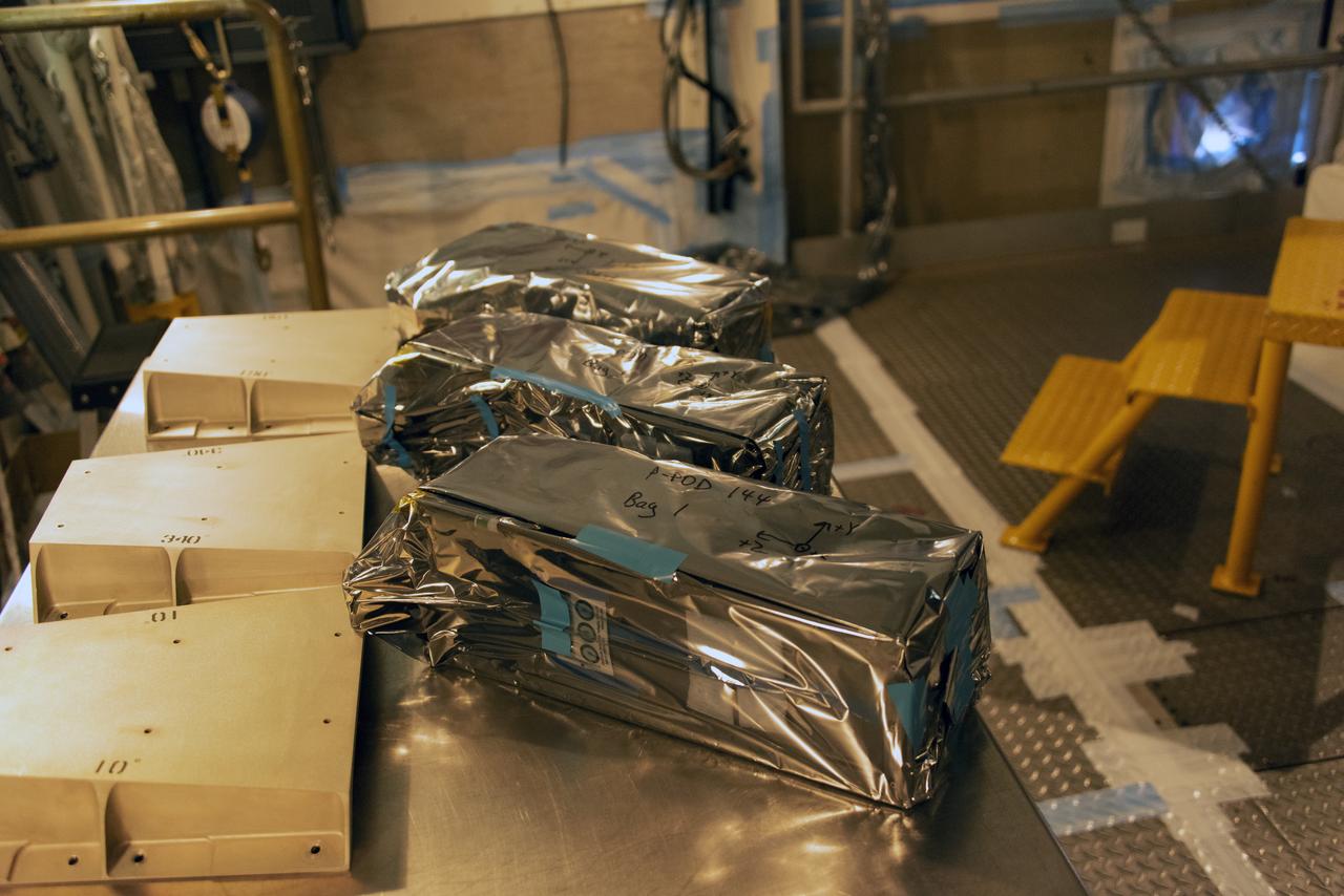
At Space Launch Complex 2 at Vandenberg Air Force Base in California, three poly picosatellite orbital deployers, or P-POD containers, with tiny satellites, called CubeSats inside, are being prepared for installation on the direct mate adapter of the United Launch Alliance Delta II rocket, on Aug. 31, 2018. NASA's Ice, Cloud and land Elevation Satellite-2 (ICESat-2) is ready for launch aboard the final Delta II rocket. Launch is scheduled for Sept. 15, 2018. ICESat-2 will measure the height of a changing Earth, one laser pulse at a time, 10,000 laser pulses a second. The satellite will carry the Advanced Topographic Laser Altimeter System (ATLAS). ICESat-2 will help scientists investigate why, and how much our planet's frozen and icy areas, called the cryosphere, are changing in a warming climate.

Tim Dunn, launch director, NASA's Kennedy Space Center in Florida, speaks to members of the news media and social media participants during a prelaunch mission briefing for NASA's Ice, Cloud and land Elevation Satellite-2 (ICESat-2), a mission to measure the changing height of Earth's ice, on Sept. 13, 2018 at Vandenberg Air Force Base (VAFB) in California. ICESat-2 will launch aboard a United Launch Alliance Delta II, the rocket’s final mission, from Space Launch Complex 2 at VAFB. Launch is scheduled for 8:46 a.m. EDT (5:46 a.m. PDT).
The gantry rolls back at Space Launch Complex 2 at Vandenberg Air Force Base in California, on Sept. 14, 2018, for the final United Launch Alliance Delta II rocket which will carry NASA's Ice, Cloud and land Elevation Satellite-2 (ICESat-2). Liftoff is scheduled for Sept. 15, 2018, at 8:46 a.m. EDT (5:46 a.m. PDT). The satellite will measure the height of our changing Earth, one laser pulse at a time, 10,000 laser pulses per second. ICESat-2 will provide scientists with height measurements that create a global portrait of Earth's third dimension, gathering date that can precisely track changes of terrain, including glaciers, sea ice and forests.
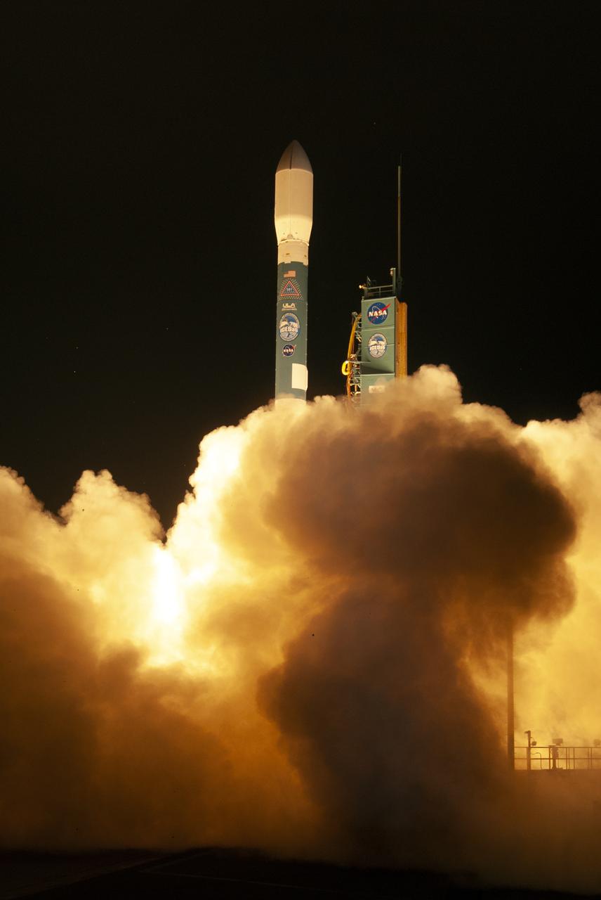
The final United Launch Alliance Delta II rocket lifts off from Space Launch Complex 2 at Vandenberg Air Force Base in California, on Sept. 15, 2018, carrying NASA's Ice, Cloud and land Elevation Satellite-2 (ICESat-2). Liftoff was at 9:02 a.m. EDT (6:02 a.m. PDT). The satellite will measure the height of our changing Earth, one laser pulse at a time, 10,000 laser pulses per second. ICESat-2 will provide scientists with height measurements that create a global portrait of Earth's third dimension, gathering date that can precisely track changes of terrain, including glaciers, sea ice and forests.
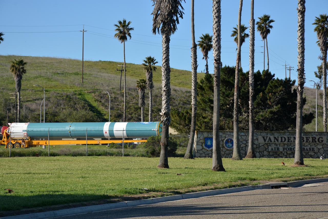
At Vandenberg Air Force Base in California, on Tuesday, April 17, 2018, a United Launch Alliance (ULA) Delta II booster is transported to Space Launch Complex-2 where it will launch NASA's Ice, Cloud and land Elevation Satellite-2, or ICESat-2, satellite. This will be the last flight for the venerable Delta II rocket. ICESat-2, which is being built and tested by Orbital ATK in Gilbert, Arizona, will carry a single instrument called the Advanced Topographic Laser Altimeter System, or ATLAS. The ATLAS instrument is being built and tested at NASA’s Goddard Space Flight Center in Greenbelt Maryland. Once in orbit, the satellite is designed to measure the height of a changing Earth, one laser pulse at a time, 10,000 laser pulses a second. ICESat-2 will help scientists investigate why, and how much, Earth’s frozen and icy areas, called the cryosphere, are changing.
The gantry rolls back at Space Launch Complex 2 at Vandenberg Air Force Base in California, on Sept. 14, 2018, for the final United Launch Alliance Delta II rocket which will carry NASA's Ice, Cloud and land Elevation Satellite-2 (ICESat-2). Liftoff is scheduled for Sept. 15, 2018, at 8:46 a.m. EDT (5:46 a.m. PDT). The satellite will measure the height of our changing Earth, one laser pulse at a time, 10,000 laser pulses per second. ICESat-2 will provide scientists with height measurements that create a global portrait of Earth's third dimension, gathering date that can precisely track changes of terrain, including glaciers, sea ice and forests.
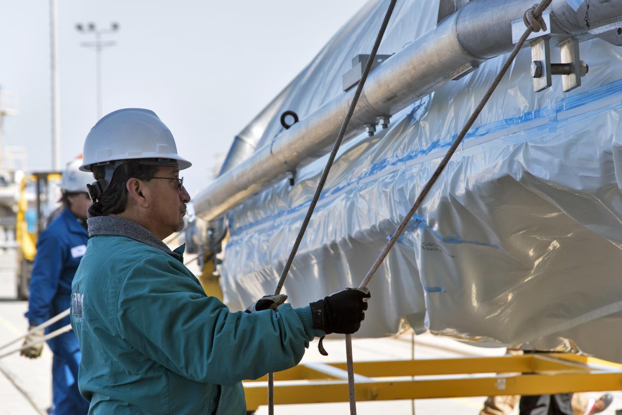
The second half of the United Launch Alliance (ULA) Delta II rocket payload fairing is being prepared for the move to the Vertical Integration Facility at Space Launch Complex 2 at Vandenberg Air Force Base in California, on June 4, 2018. NASA's Ice, Cloud and land Elevation Satellite-2 (ICESat-2) will launch later this year on the final Delta II rocket. ICESat-2 will measure the height of a changing Earth, one laser pulse at a time, 10,000 laser pulses a second. The satellite will carry a single instrument, the Advanced Topographic Laser Altimeter System. ICESat-2 will help scientists investigate why, and how much our planet's frozen and icy areas, called the cryosphere, is changing in a warming climate.
Inside the high bay of the Astrotech Space Operations facility at Vandenberg Air Force Base in California, technicians prepare to attach NASA's Ice, Cloud and land Elevation Satellite-2 (ICESat-2) to the payload adapter, on Aug. 20, 2018. The satellite is being prepared for its scheduled launch from Space Launch Complex 2 at Vandenberg on the final United Launch Alliance Delta II rocket. ICESat-2 will measure the height of a changing Earth, one laser pulse at a time, 10,000 laser pulses a second. The satellite will carry the Advanced Topographic Laser Altimeter System (ATLAS). ICESat-2 will help scientists investigate why, and how much our planet's frozen and icy areas, called the cryosphere, are changing in a warming climate.
A United Launch Alliance Delta II booster arrives at NASA's Building 836, the Spacecraft Labs Telemetry Station at Vandenberg Air Force Base in California. It will be offloaded and begin preliminary checkouts and preflight processing for launch of the agency's Ice, Cloud and land Elevation Satellite-2, or ICESat-2. Liftoff from Space Launch Complex-2 at Vandenberg is scheduled for Sept. 12, 2018, and will be the last for the venerable Delta II rocket. Once in orbit, the satellite is designed to measure the height of a changing Earth, one laser pulse at a time, 10,000 laser pulses a second. The satellite will carry a single instrument, the Advanced Topographic Laser Altimeter System. ICESat-2 will help scientists investigate why, and how much, Earth's frozen and icy areas are changing. These area make up Earth's the cryosphere.
The gantry rolls back at Space Launch Complex 2 at Vandenberg Air Force Base in California, on Sept. 14, 2018, for the final United Launch Alliance Delta II rocket which will carry NASA's Ice, Cloud and land Elevation Satellite-2 (ICESat-2). Liftoff is scheduled for Sept. 15, 2018, at 8:46 a.m. EDT (5:46 a.m. PDT). The satellite will measure the height of our changing Earth, one laser pulse at a time, 10,000 laser pulses per second. ICESat-2 will provide scientists with height measurements that create a global portrait of Earth's third dimension, gathering date that can precisely track changes of terrain, including glaciers, sea ice and forests.
The United Launch Alliance Delta II first stage arrives at Space Launch Complex 2 on June 8, 2018, at Vandenberg Air Force Base in California. The booster will be lifted to vertical and moved into the mobile service tower. NASA's Ice, Cloud and land Elevation Satellite-2 (ICESat-2) will launch on the final Delta II rocket. ICESat-2 will measure the height of a changing Earth, one laser pulse at a time, 10,000 laser pulses a second. The satellite will carry a single instrument, the Advanced Topographic Laser Altimeter System. ICESat-2 will help scientists investigate why, and how much our planet's frozen and icy areas, called the cryosphere, is changing in a warming climate.
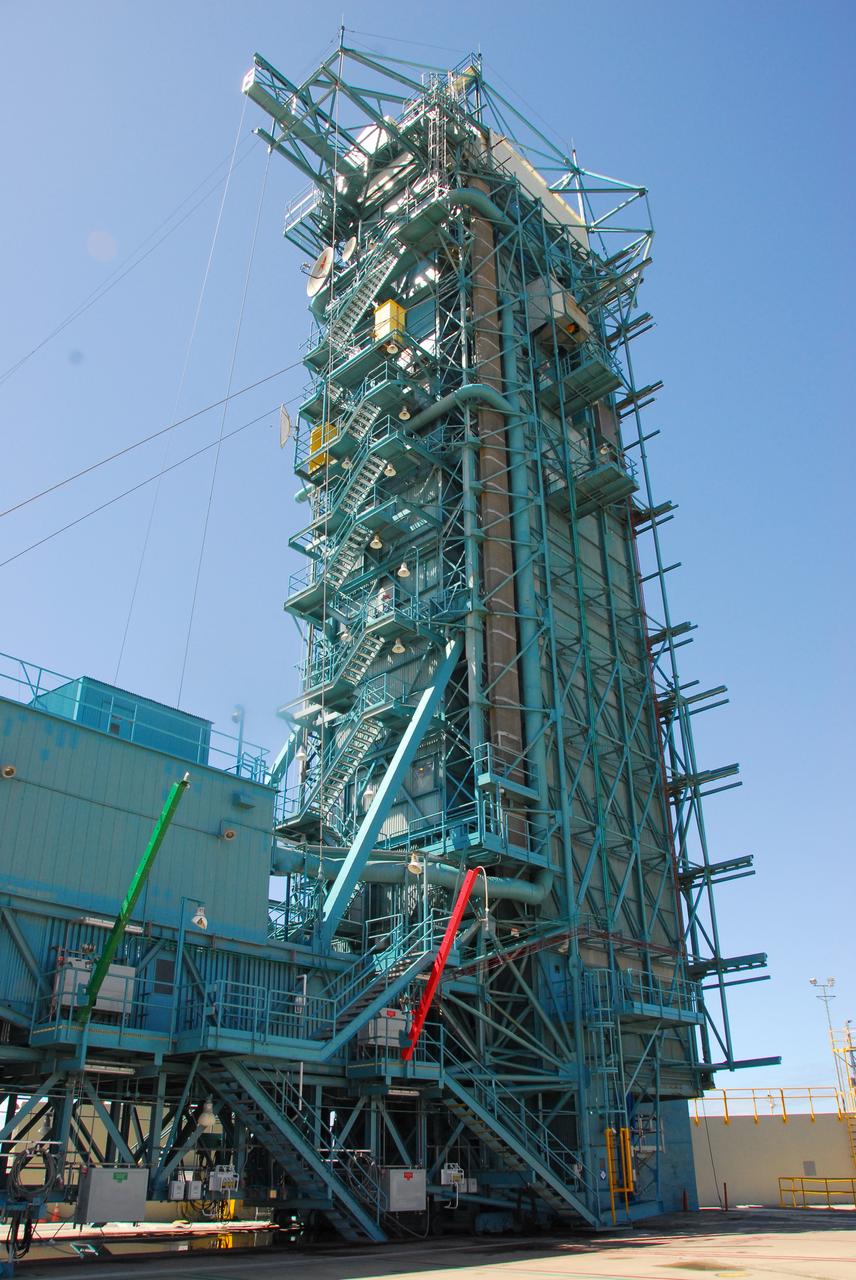
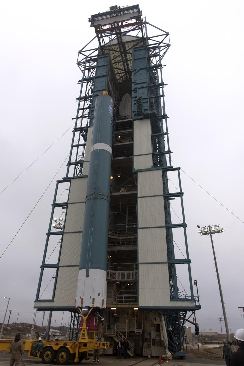
Protective doors have been closed on the mobile service tower at Space Launch Complex 2 at Vandenberg Air Force Base in California, on June 8, 2018. The United Launch Alliance Delta II first stage is lifted up and secured inside the tower. NASA's Ice, Cloud and land Elevation Satellite-2 (ICESat-2) will launch on the final Delta II rocket. ICESat-2 will measure the height of a changing Earth, one laser pulse at a time, 10,000 laser pulses a second. The satellite will carry a single instrument, the Advanced Topographic Laser Altimeter System. ICESat-2 will help scientists investigate why, and how much our planet's frozen and icy areas, called the cryosphere, is changing in a warming climate.
The first half of the United Launch Alliance (ULA) Delta II rocket payload fairing is lifted up and into the Vertical Integration Facility at Space Launch Complex 2 at Vandenberg Air Force Base in California, on June 4, 2018. NASA's Ice, Cloud and land Elevation Satellite-2 (ICESat-2) will launch later this year on the final Delta II rocket. ICESat-2 will measure the height of a changing Earth, one laser pulse at a time, 10,000 laser pulses a second. The satellite will carry a single instrument, the Advanced Topographic Laser Altimeter System. ICESat-2 will help scientists investigate why, and how much our planet's frozen and icy areas, called the cryosphere, is changing in a warming climate.
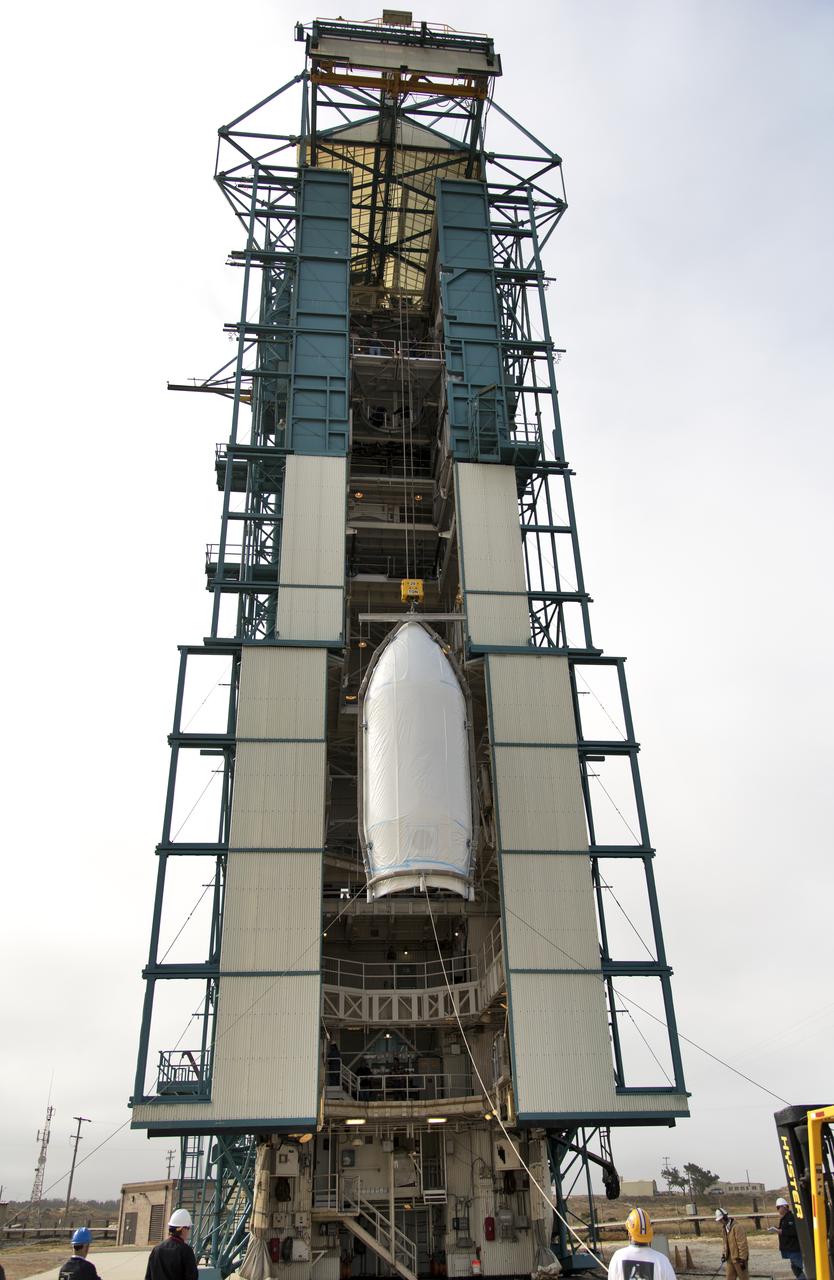
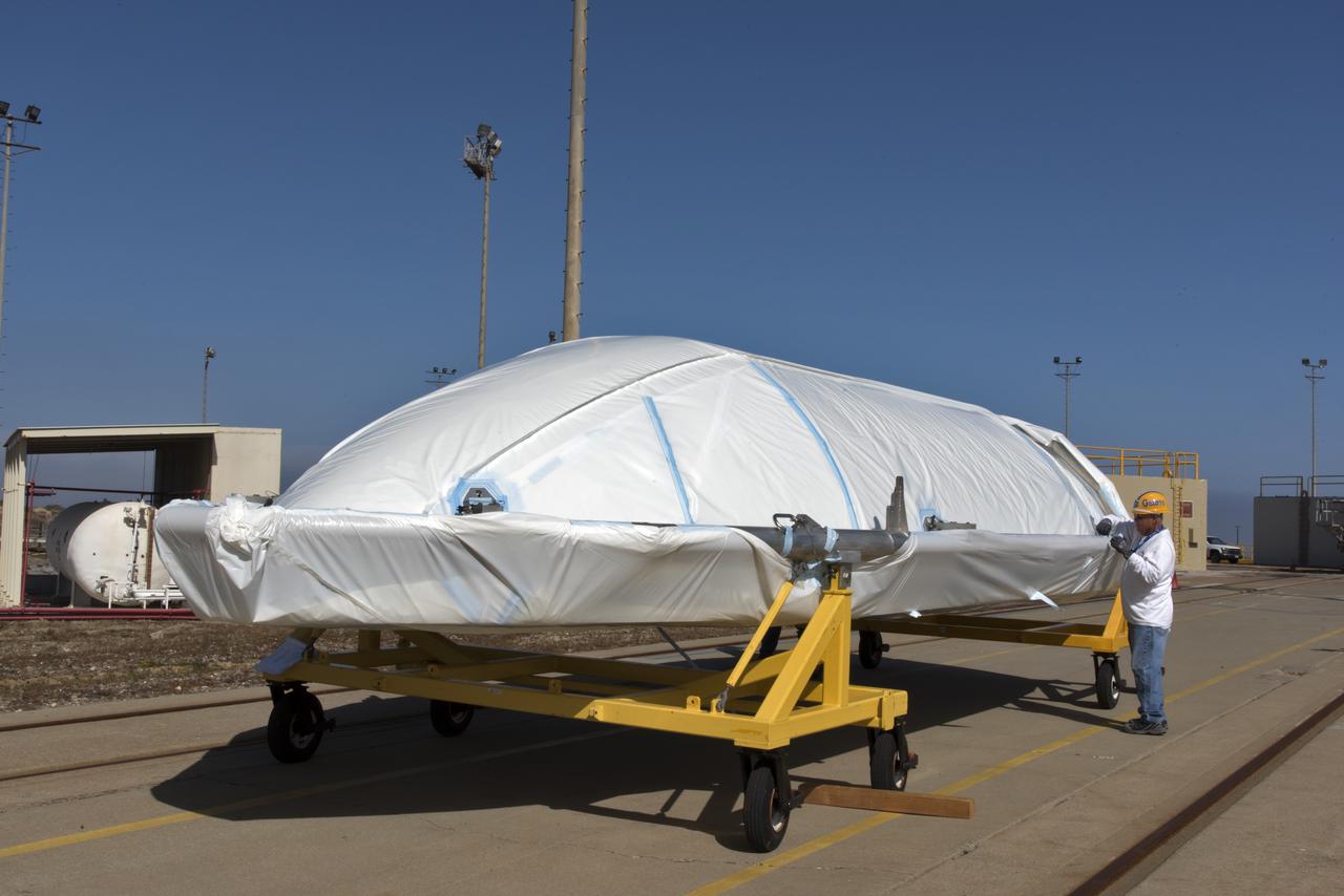
NASA's Ice, Cloud and land Elevation Satellite-2 (ICESat-2), at right, encased in its protective covering, arrives at the mobile service tower at Space Launch Complex 2 at Vandenberg Air Force Base in California, on Aug. 26, 2018. The satellite will be hoisted up by crane and attached to the United Launch Alliance Delta II rocket. Launch is scheduled for Sept. 15, 2018. ICESat-2 will measure the height of a changing Earth, one laser pulse at a time, 10,000 laser pulses a second. The satellite will carry the Advanced Topographic Laser Altimeter System (ATLAS). ICESat-2 will help scientists investigate why, and how much our planet's frozen and icy areas, called the cryosphere, are changing in a warming climate.
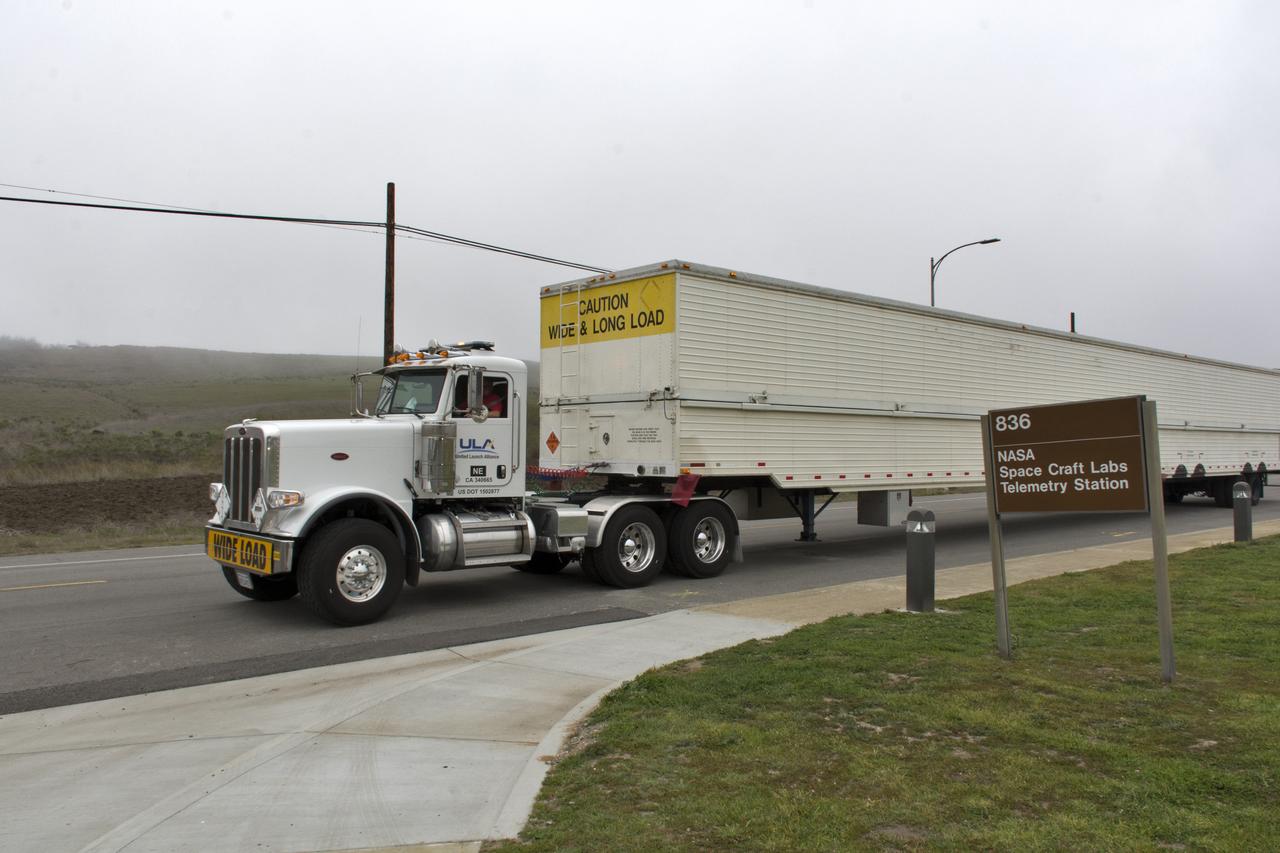
A United Launch Alliance Delta II booster arrives at NASA's Building 836, the Spacecraft Labs Telemetry Station at Vandenberg Air Force Base in California. It will be offloaded and begin preliminary checkouts and preflight processing for launch of the agency's Ice, Cloud and land Elevation Satellite-2, or ICESat-2. Liftoff from Space Launch Complex-2 at Vandenberg is scheduled for Sept. 12, 2018, and will be the last for the venerable Delta II rocket. Once in orbit, the satellite is designed to measure the height of a changing Earth, one laser pulse at a time, 10,000 laser pulses a second. The satellite will carry a single instrument, the Advanced Topographic Laser Altimeter System. ICESat-2 will help scientists investigate why, and how much, Earth's frozen and icy areas are changing. These area make up Earth's the cryosphere.
The second half of the United Launch Alliance (ULA) Delta II rocket payload fairing is being prepared for the move to the Vertical Integration Facility at Space Launch Complex 2 at Vandenberg Air Force Base in California, on June 4, 2018. NASA's Ice, Cloud and land Elevation Satellite-2 (ICESat-2) will launch later this year on the final Delta II rocket. ICESat-2 will measure the height of a changing Earth, one laser pulse at a time, 10,000 laser pulses a second. The satellite will carry a single instrument, the Advanced Topographic Laser Altimeter System. ICESat-2 will help scientists investigate why, and how much our planet's frozen and icy areas, called the cryosphere, is changing in a warming climate.
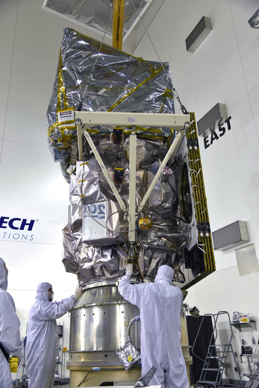
NASA's Ice, Cloud and land Elevation Satellite-2 (ICESat-2) is lifted in its fixture inside the high bay of the Astrotech Space Operations facility on June 14, 2018, at Vandenberg Air Force Base in California. ICESat-2 was shipped from the Northrop Grumman facility in Gilbert, Arizona, where it was built and tested. The satellite is scheduled to launch from Space Launch Complex-2 at Vandenberg on the final United Launch Alliance Delta II rocket. ICESat-2 will measure the height of a changing Earth, one laser pulse at a time, 10,000 laser pulses a second. The satellite will carry the Advanced Topographic Laser Altimeter System. ICESat-2 will help scientists investigate why, and how much our planet's frozen and icy areas, called the cryosphere, is changing in a warming climate.
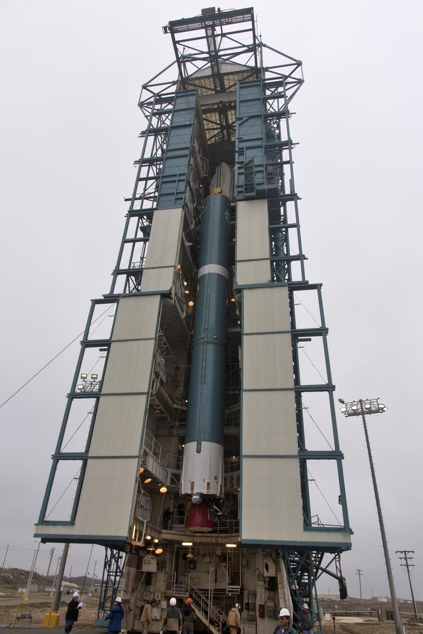
The second stage of the United Launch Alliance Delta II rocket is lifted high up at the Vertical Integration Facility, at left, at Space Launch Complex 2 on June 21, 2018, at Vandenberg Air Force Base in California. The second stage will be attached to the top of the booster, or first stage of the rocket, which is being moved out of the Mobile Service Tower, at right. NASA's Ice, Cloud and land Elevation Satellite-2 (ICESat-2) will launch on the final Delta II rocket. ICESat-2 will measure the height of a changing Earth, one laser pulse at a time, 10,000 laser pulses a second. The satellite will carry a single instrument, the Advanced Topographic Laser Altimeter System. ICESat-2 will help scientists investigate why, and how much our planet's frozen and icy areas, called the cryosphere, is changing in a warming climate.
Inside the high bay of the Astrotech Space Operations facility at Vandenberg Air Force Base in California, a technician checks the flight door for the Advanced Topographic Laser Altimeter System (ATLAS) on NASA's Ice, Cloud and land Elevation Satellite-2 (ICESat-2) on June 21, 2018. The satellite is being prepared for its scheduled launch from Space Launch Complex-2 at Vandenberg on the final United Launch Alliance Delta II rocket. ICESat-2 will measure the height of a changing Earth, one laser pulse at a time, 10,000 laser pulses a second. The satellite will carry ATLAS. ICESat-2 will help scientists investigate why, and how much our planet's frozen and icy areas, called the cryosphere, is changing in a warming climate.

Inside the high bay of the Astrotech Space Operations facility at Vandenberg Air Force Base in California, a technician checks the flight door for the Advanced Topographic Laser Altimeter System (ATLAS) on NASA's Ice, Cloud and land Elevation Satellite-2 (ICESat-2) on June 21, 2018. The satellite is being prepared for its scheduled launch from Space Launch Complex-2 at Vandenberg on the final United Launch Alliance Delta II rocket. ICESat-2 will measure the height of a changing Earth, one laser pulse at a time, 10,000 laser pulses a second. The satellite will carry ATLAS. ICESat-2 will help scientists investigate why, and how much our planet's frozen and icy areas, called the cryosphere, is changing in a warming climate.
The United Launch Alliance Delta II interstage is lifted up at the Vertical Integration Facility at Space Launch Complex 2 on June 12, 2018, at Vandenberg Air Force Base in California. The interstage will be moved in and mated to the top of the booster, or first stage of the rocket. NASA's Ice, Cloud and land Elevation Satellite-2 (ICESat-2) will launch on the final Delta II rocket. ICESat-2 will measure the height of a changing Earth, one laser pulse at a time, 10,000 laser pulses a second. The satellite will carry a single instrument, the Advanced Topographic Laser Altimeter System. ICESat-2 will help scientists investigate why, and how much our planet's frozen and icy areas, called the cryosphere, is changing in a warming climate.
At Vandenberg Air Force Base in California, on Tuesday, April 17, 2018, a United Launch Alliance (ULA) Delta II booster is transported to Space Launch Complex-2 where it will launch NASA's Ice, Cloud and land Elevation Satellite-2, or ICESat-2, satellite. This will be the last flight for the venerable Delta II rocket. ICESat-2, which is being built and tested by Orbital ATK in Gilbert, Arizona, will carry a single instrument called the Advanced Topographic Laser Altimeter System, or ATLAS. The ATLAS instrument is being built and tested at NASA’s Goddard Space Flight Center in Greenbelt Maryland. Once in orbit, the satellite is designed to measure the height of a changing Earth, one laser pulse at a time, 10,000 laser pulses a second. ICESat-2 will help scientists investigate why, and how much, Earth’s frozen and icy areas, called the cryosphere, are changing.

A photon demonstration was conducted in front of news media and social media participants during a prelaunch mission briefing for NASA's Ice, Cloud and land Elevation Satellite-2 (ICESat-2), a mission to measure the changing height of Earth's ice, on Sept. 13, 2018 at Vandenberg Air Force Base (VAFB) in California. ICESat-2 will launch aboard a United Launch Alliance Delta II, the rocket’s final mission, from Space Launch Complex 2 at VAFB. Launch is scheduled for 8:46 a.m. EDT (5:46 a.m. PDT). The satellite will measure the height of our changing Earth, one laser pulse at a time, 10,000 laser pulses per second. ICESat-2 will provide scientists with height measurements that create a global portrait of Earth's third dimension, gathering date that can precisely track changes of terrain, including glaciers, sea ice and forests.
Inside the high bay of the Astrotech Space Operations facility at Vandenberg Air Force Base in California, technicians help secure NASA's Ice, Cloud and land Elevation Satellite-2 (ICESat-2) to the payload adapter on Aug. 30, 2018. ICESat-2 is being prepared for its scheduled launch from Space Launch Complex 2 at Vandenberg on the final United Launch Alliance Delta II rocket. ICESat-2 will measure the height of a changing Earth, one laser pulse at a time, 10,000 laser pulses a second. The satellite will carry the Advanced Topographic Laser Altimeter System (ATLAS). ICESat-2 will help scientists investigate why, and how much our planet's frozen and icy areas, called the cryosphere, are changing in a warming climate.
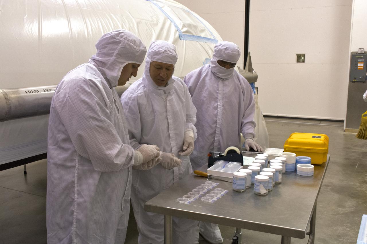
On Friday, April 6, 2018, in NASA’s Building 8337 at Vandenberg Air Force Base in California, technicians and engineers check samples during cleaning of the payload fairing that will protect NASA's Ice, Cloud and land Elevation Satellite-2, or ICESat-2, satellite during launch. Liftoff atop a United Launch Alliance Delta II rocket is scheduled for Sept. 12, 2018, from Space Launch Complex-2 at Vandenberg. It will be the last for the venerable Delta II rocket. ICESat-2, which is being built and tested by Orbital ATK in Gilbert, Arizona, will carry a single instrument called the Advanced Topographic Laser Altimeter System, or ATLAS. The ATLAS instrument is being built and tested at NASA’s Goddard Space Flight Center in Greenbelt Maryland. Once in orbit, the satellite is designed to measure the height of a changing Earth, one laser pulse at a time, 10,000 laser pulses a second. ICESat-2 will help scientists investigate why, and how much, Earth’s frozen and icy areas, called the cryosphere, are changing.

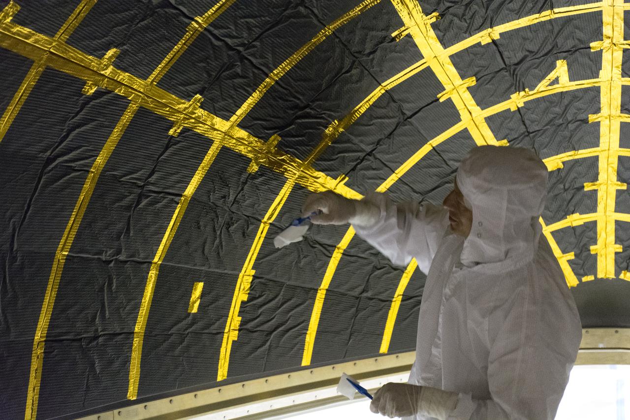
The first half of the United Launch Alliance Delta II payload fairing is secured around NASA's Ice, Cloud and land Elevation Satellite-2 (ICESat-2) on Sept. 4, 2018, at Space Launch Complex 2 at Vandenberg Air Force Base in California. The satellite is being prepared for its scheduled launch on the final Delta II rocket. ICESat-2 will measure the height of a changing Earth, one laser pulse at a time, 10,000 laser pulses a second. The satellite will carry the Advanced Topographic Laser Altimeter System (ATLAS). ICESat-2 will help scientists investigate why, and how much our planet's frozen and icy areas, called the cryosphere, are changing in a warming climate.
Inside the high bay of the Astrotech Space Operations facility at Vandenberg Air Force Base in California, technicians attach NASA's Ice, Cloud and land Elevation Satellite-2 (ICESat-2) to the payload direct mate adapter, on Aug. 24, 2018. The satellite is being prepared for its scheduled launch from Space Launch Complex 2 at Vandenberg on the final United Launch Alliance Delta II rocket. ICESat-2 will measure the height of a changing Earth, one laser pulse at a time, 10,000 laser pulses a second. The satellite will carry the Advanced Topographic Laser Altimeter System (ATLAS). ICESat-2 will help scientists investigate why, and how much our planet's frozen and icy areas, called the cryosphere, are changing in a warming climate.
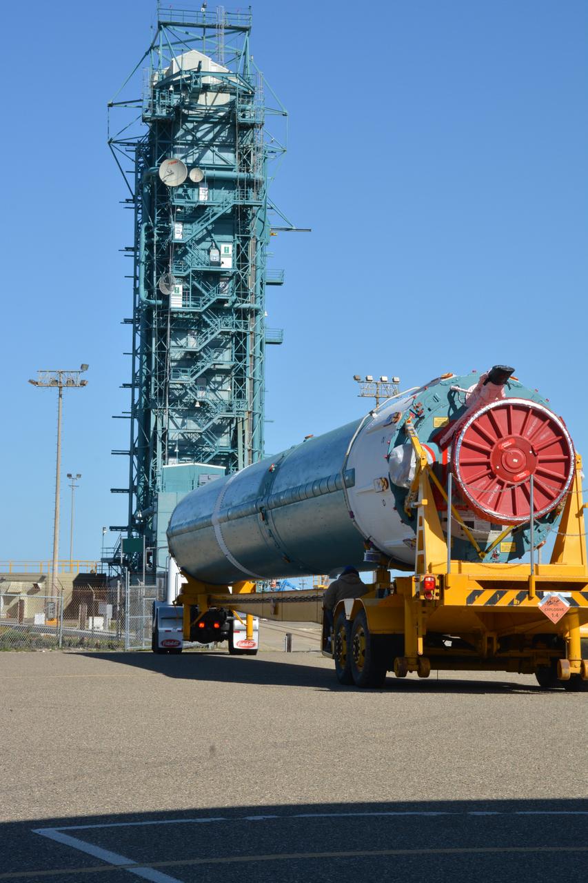
At Vandenberg Air Force Base in California, on Tuesday, April 17, 2018, a United Launch Alliance (ULA) Delta II booster arrives at Space Launch Complex-2 where it will launch NASA's Ice, Cloud and land Elevation Satellite-2, or ICESat-2, satellite. This will be the last flight for the venerable Delta II rocket. ICESat-2, which is being built and tested by Orbital ATK in Gilbert, Arizona, will carry a single instrument called the Advanced Topographic Laser Altimeter System, or ATLAS. The ATLAS instrument is being built and tested at NASA’s Goddard Space Flight Center in Greenbelt Maryland. Once in orbit, the satellite is designed to measure the height of a changing Earth, one laser pulse at a time, 10,000 laser pulses a second. ICESat-2 will help scientists investigate why, and how much, Earth’s frozen and icy areas, called the cryosphere, are changing.
The final United Launch Alliance Delta II rocket lifts off from Space Launch Complex 2 at Vandenberg Air Force Base in California, on Sept. 15, 2018, carrying NASA's Ice, Cloud and land Elevation Satellite-2 (ICESat-2). Liftoff was at 9:02 a.m. EDT (6:02 a.m. PDT). The satellite will measure the height of our changing Earth, one laser pulse at a time, 10,000 laser pulses per second. ICESat-2 will provide scientists with height measurements that create a global portrait of Earth's third dimension, gathering date that can precisely track changes of terrain, including glaciers, sea ice and forests.
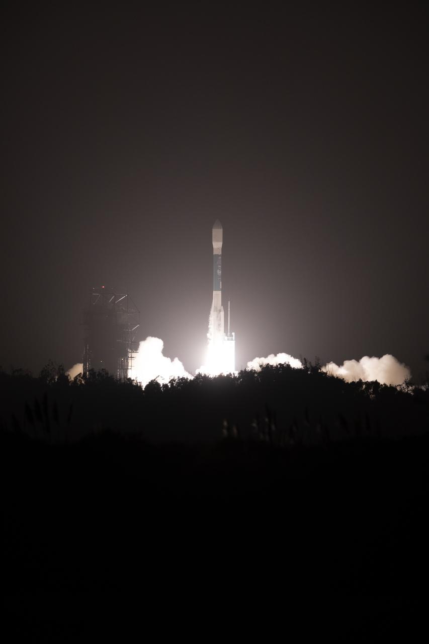
The final United Launch Alliance Delta II rocket lifts off from Space Launch Complex 2 at Vandenberg Air Force Base in California, on Sept. 15, 2018, carrying NASA's Ice, Cloud and land Elevation Satellite-2 (ICESat-2). Liftoff was at 9:02 a.m. EDT (6:02 a.m. PDT). The satellite will measure the height of our changing Earth, one laser pulse at a time, 10,000 laser pulses per second. ICESat-2 will provide scientists with height measurements that create a global portrait of Earth's third dimension, gathering date that can precisely track changes of terrain, including glaciers, sea ice and forests.
The solid rocket motor for mating to the United Launch Alliance Delta II launch vehicle arrives at the Vertical Integration Facility (VIF) at Space Launch Complex 2 on June 14, 2018, at Vandenberg Air Force Base in California. The solid rocket motor will be lifted up and attached to the rocket. NASA's Ice, Cloud and land Elevation Satellite-2 (ICESat-2) will launch on the final Delta II rocket. ICESat-2 will measure the height of a changing Earth, one laser pulse at a time, 10,000 laser pulses a second. The satellite will carry a single instrument, the Advanced Topographic Laser Altimeter System. ICESat-2 will help scientists investigate why, and how much our planet's frozen and icy areas, called the cryosphere, is changing in a warming climate.
Technicians assist as a crane lowers NASA's Ice, Cloud and land Elevation Satellite-2 (ICESat-2) onto a work stand in the high bay of the Astrotech Space Operations facility on June 14, 2018, at Vandenberg Air Force Base in California. ICESat-2 was shipped from the Northrop Grumman facility in Gilbert, Arizona, where it was built and tested. The satellite is scheduled to launch from Space Launch Complex-2 at Vandenberg on the final United Launch Alliance Delta II rocket. ICESat-2 will measure the height of a changing Earth, one laser pulse at a time, 10,000 laser pulses a second. The satellite will carry the Advanced Topographic Laser Altimeter System. ICESat-2 will help scientists investigate why, and how much our planet's frozen and icy areas, called the cryosphere, is changing in a warming climate.
The United Launch Alliance Delta II first stage is lifted up in the mobile service tower at Space Launch Complex 2 on June 8, 2018, at Vandenberg Air Force Base in California. NASA's Ice, Cloud and land Elevation Satellite-2 (ICESat-2) will launch on the final Delta II rocket. ICESat-2 will measure the height of a changing Earth, one laser pulse at a time, 10,000 laser pulses a second. The satellite will carry a single instrument, the Advanced Topographic Laser Altimeter System. ICESat-2 will help scientists investigate why, and how much our planet's frozen and icy areas, called the cryosphere, is changing in a warming climate.

The gantry rolls back at Space Launch Complex 2 at Vandenberg Air Force Base in California, on Sept. 14, 2018, for the final United Launch Alliance Delta II rocket which will carry NASA's Ice, Cloud and land Elevation Satellite-2 (ICESat-2). Liftoff is scheduled for Sept. 15, 2018, at 8:46 a.m. EDT (5:46 a.m. PDT). The satellite will measure the height of our changing Earth, one laser pulse at a time, 10,000 laser pulses per second. ICESat-2 will provide scientists with height measurements that create a global portrait of Earth's third dimension, gathering date that can precisely track changes of terrain, including glaciers, sea ice and forests.
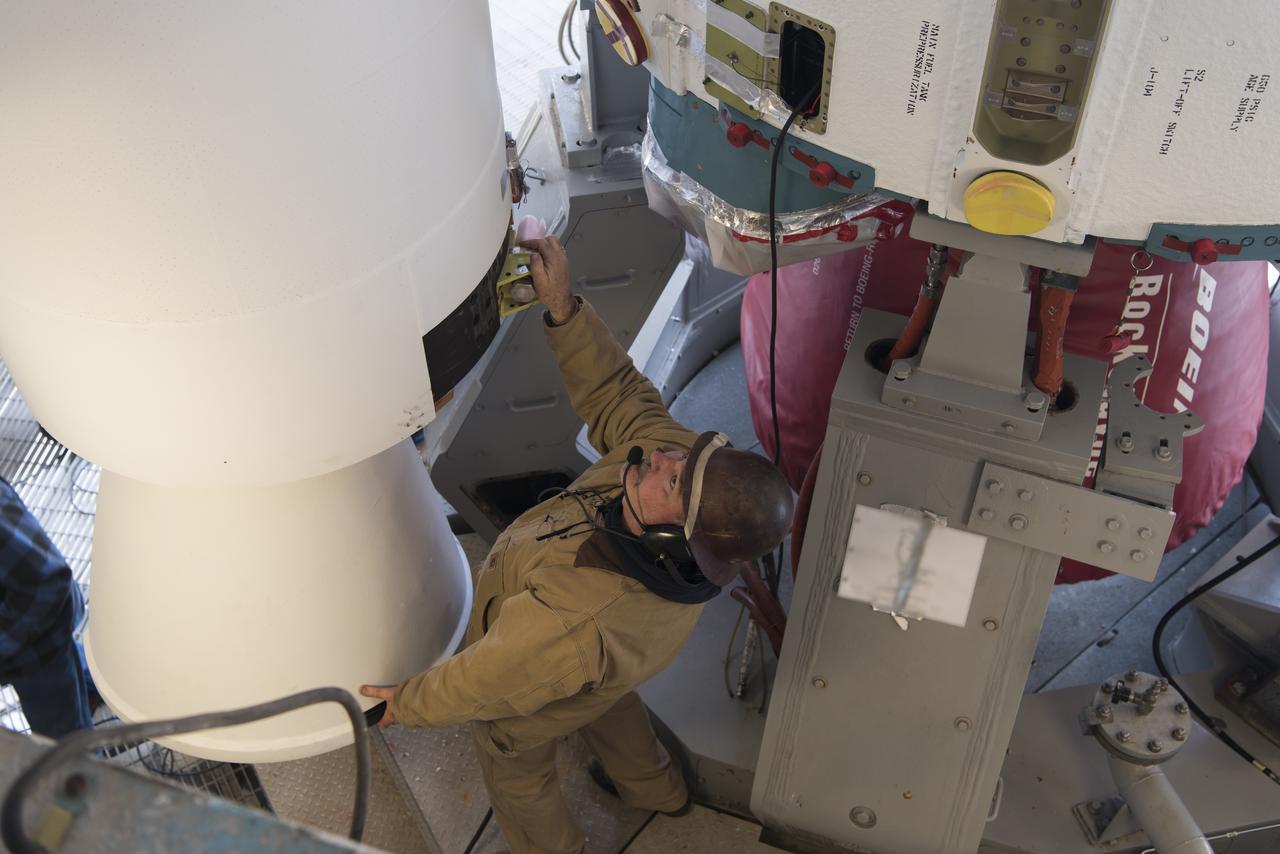
United Launch Alliance (ULA) technicians assist as the solid rocket motor is moved toward the Delta II launch vehicle in the Vertical Integration Facility (VIF) at Space Launch Complex 2 on June 14, 2018, at Vandenberg Air Force Base in California. The solid rocket motor will be attached to the rocket. NASA's Ice, Cloud and land Elevation Satellite-2 (ICESat-2) will launch on the final ULA Delta II rocket. ICESat-2 will measure the height of a changing Earth, one laser pulse at a time, 10,000 laser pulses a second. The satellite will carry a single instrument, the Advanced Topographic Laser Altimeter System. ICESat-2 will help scientists investigate why, and how much our planet's frozen and icy areas, called the cryosphere, is changing in a warming climate.
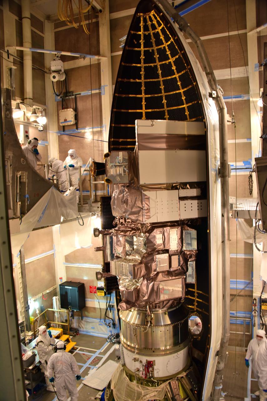
The first half of the United Launch Alliance Delta II payload fairing is secured around NASA's Ice, Cloud and land Elevation Satellite-2 (ICESat-2) on Sept. 4, 2018, at Space Launch Complex 2 at Vandenberg Air Force Base in California. The satellite is being prepared for its scheduled launch on the final Delta II rocket. ICESat-2 will measure the height of a changing Earth, one laser pulse at a time, 10,000 laser pulses a second. The satellite will carry the Advanced Topographic Laser Altimeter System (ATLAS). ICESat-2 will help scientists investigate why, and how much our planet's frozen and icy areas, called the cryosphere, are changing in a warming climate.
Tom Neumann, ICESat-2 deputy project scientist, NASA's Goddard Space Flight Center, speaks to members of the news media and social media participants during a prelaunch mission briefing for NASA's Ice, Cloud and land Elevation Satellite-2 (ICESat-2), a mission to measure the changing height of Earth's ice, on Sept. 13, 2018 at Vandenberg Air Force Base (VAFB) in California. ICESat-2 will launch aboard a United Launch Alliance Delta II, the rocket’s final mission, from Space Launch Complex 2 at VAFB. Launch is scheduled for 8:46 a.m. EDT (5:46 a.m. PDT).
Technicians assist as a crane lowers NASA's Ice, Cloud and land Elevation Satellite-2 (ICESat-2) onto a work stand in the high bay of the Astrotech Space Operations facility on June 14, 2018, at Vandenberg Air Force Base in California. ICESat-2 was shipped from the Northrop Grumman facility in Gilbert, Arizona, where it was built and tested. The satellite is scheduled to launch from Space Launch Complex-2 at Vandenberg on the final United Launch Alliance Delta II rocket. ICESat-2 will measure the height of a changing Earth, one laser pulse at a time, 10,000 laser pulses a second. The satellite will carry the Advanced Topographic Laser Altimeter System. ICESat-2 will help scientists investigate why, and how much our planet's frozen and icy areas, called the cryosphere, is changing in a warming climate.
On Friday, April 6, 2018, in NASA’s Building 8337 at Vandenberg Air Force Base in California, a technician cleans and takes samples from the payload fairing the will protect NASA's Ice, Cloud and land Elevation Satellite-2, or ICESat-2, satellite during launch. Liftoff atop a United Launch Alliance Delta II rocket is scheduled for Sept. 12, 2018, from Space Launch Complex-2 at Vandenberg. It will be the last for the venerable Delta II rocket. ICESat-2, which is being built and tested by Orbital ATK in Gilbert, Arizona, will carry a single instrument called the Advanced Topographic Laser Altimeter System, or ATLAS. The ATLAS instrument is being built and tested at NASA’s Goddard Space Flight Center in Greenbelt Maryland. Once in orbit, the satellite is designed to measure the height of a changing Earth, one laser pulse at a time, 10,000 laser pulses a second. ICESat-2 will help scientists investigate why, and how much, Earth’s frozen and icy areas, called the cryosphere, are changing.
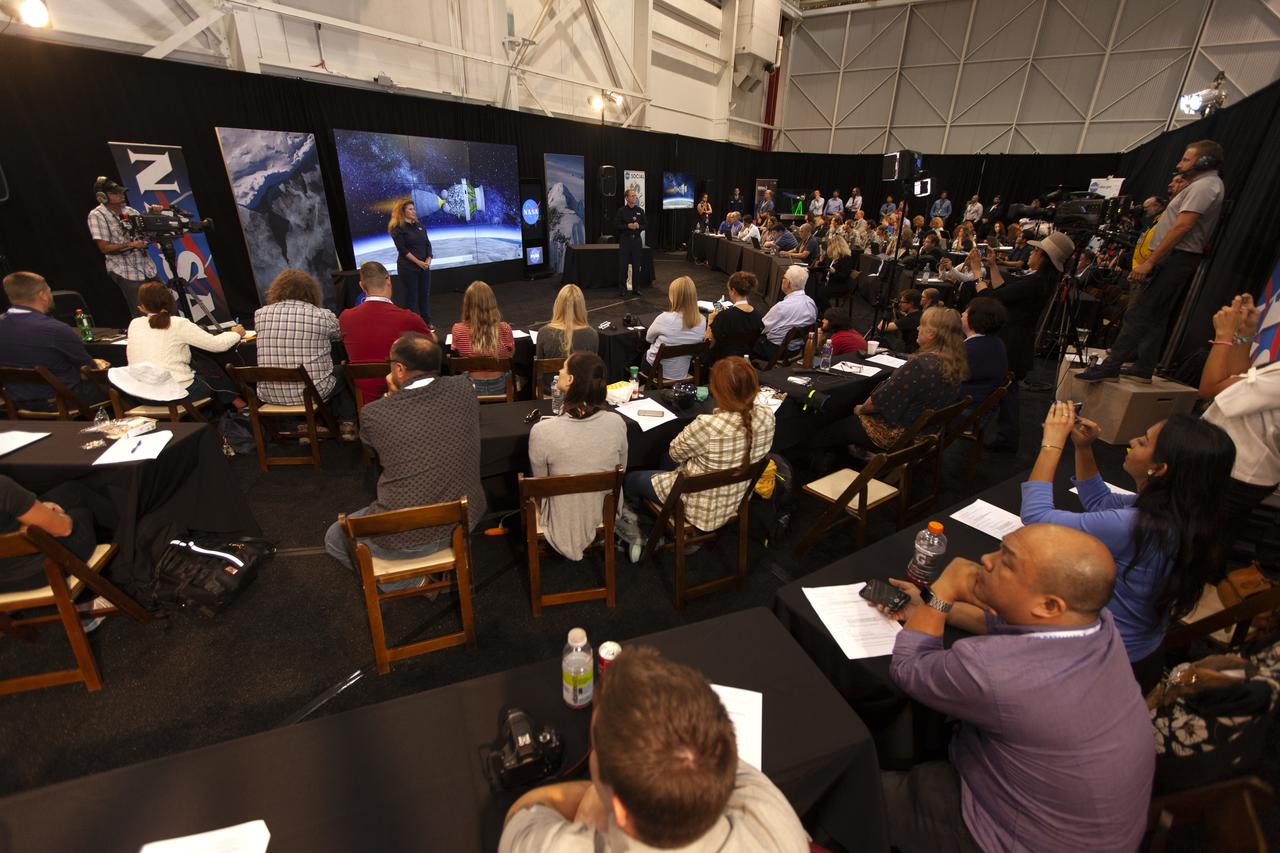
NASA and industry leaders speak to members of the news media and social media participants during a prelaunch mission briefing for NASA's Ice, Cloud and land Elevation Satellite-2 (ICESat-2) on Sept. 13, 2018, at Vandenberg Air Force Base (VAFB) in California. ICESat-2 will launch aboard a United Launch Alliance Delta II, the rocket’s final mission, from Space Launch Complex 2 at VAFB. Launch is scheduled for 8:46 a.m. EDT (5:46 a.m. PDT). The satellite will measure the height of our changing Earth, one laser pulse at a time, 10,000 laser pulses per second. ICESat-2 will provide scientists with height measurements that create a global portrait of Earth's third dimension, gathering date that can precisely track changes of terrain, including glaciers, sea ice and forests.
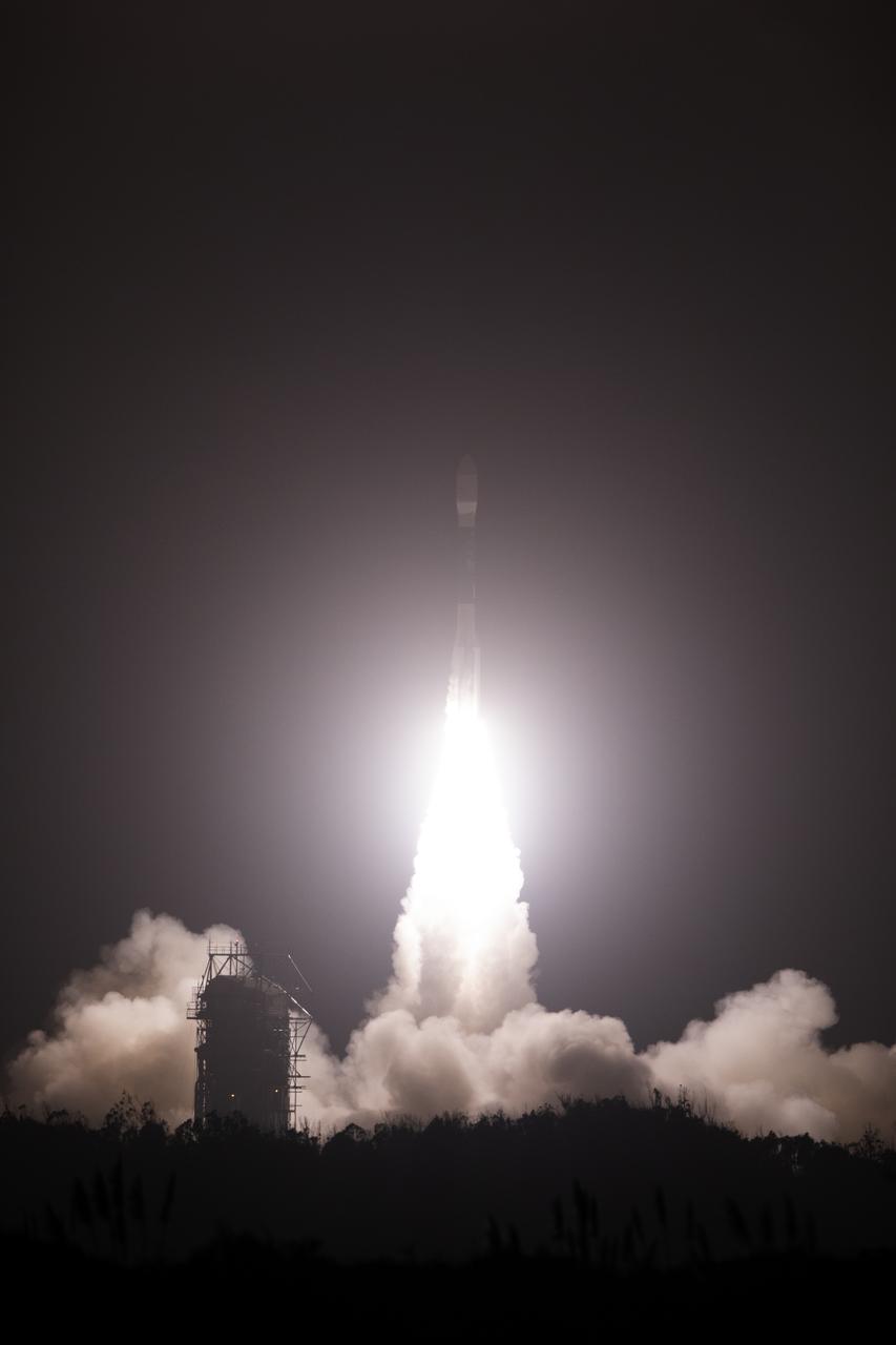
The final United Launch Alliance Delta II rocket lifts off from Space Launch Complex 2 at Vandenberg Air Force Base in California, on Sept. 15, 2018, carrying NASA's Ice, Cloud and land Elevation Satellite-2 (ICESat-2). Liftoff was at 9:02 a.m. EDT (6:02 a.m. PDT). The satellite will measure the height of our changing Earth, one laser pulse at a time, 10,000 laser pulses per second. ICESat-2 will provide scientists with height measurements that create a global portrait of Earth's third dimension, gathering date that can precisely track changes of terrain, including glaciers, sea ice and forests.
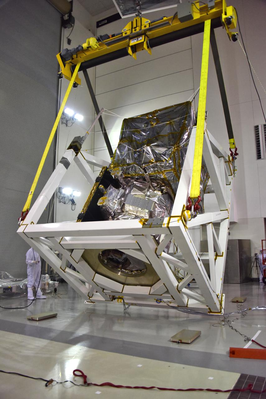
A crane is used to rotate NASA's Ice, Cloud and land Elevation Satellite-2 (ICESat-2) in its fixture inside the high bay of the Astrotech Space Operations facility on June 14, 2018, at Vandenberg Air Force Base in California. ICESat-2 was shipped from the Northrop Grumman facility in Gilbert, Arizona, where it was built and tested. The satellite is scheduled to launch from Space Launch Complex-2 at Vandenberg on the final United Launch Alliance Delta II rocket. ICESat-2 will measure the height of a changing Earth, one laser pulse at a time, 10,000 laser pulses a second. The satellite will carry the Advanced Topographic Laser Altimeter System. ICESat-2 will help scientists investigate why, and how much our planet's frozen and icy areas, called the cryosphere, is changing in a warming climate.
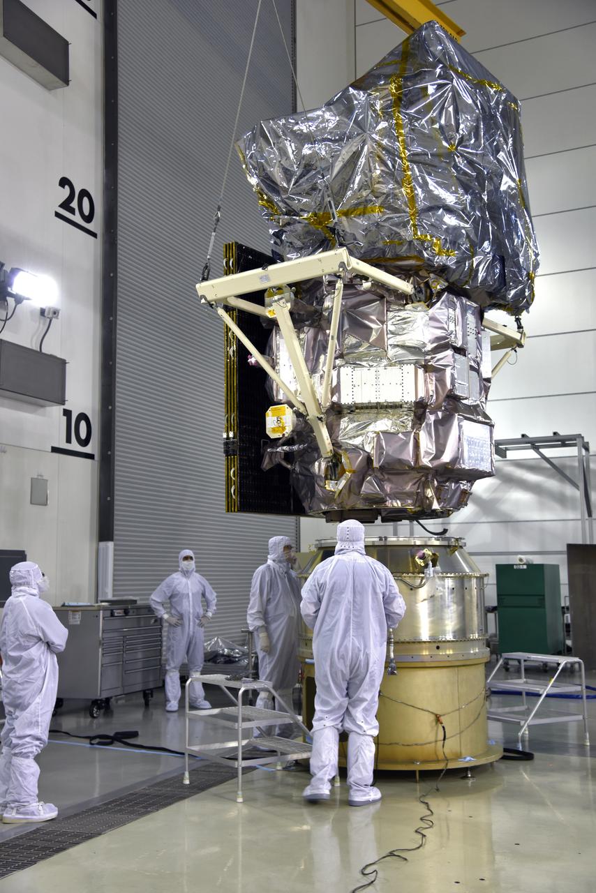
Inside the high bay of the Astrotech Space Operations facility at Vandenberg Air Force Base in California, a crane lifts and moves NASA's Ice, Cloud and land Elevation Satellite-2 (ICESat-2) over the payload adapter on Aug. 30, 2018. The satellite will be attached to the adapter. ICESat-2 is being prepared for its scheduled launch from Space Launch Complex 2 at Vandenberg on the final United Launch Alliance Delta II rocket. ICESat-2 will measure the height of a changing Earth, one laser pulse at a time, 10,000 laser pulses a second. The satellite will carry the Advanced Topographic Laser Altimeter System (ATLAS). ICESat-2 will help scientists investigate why, and how much our planet's frozen and icy areas, called the cryosphere, are changing in a warming climate.