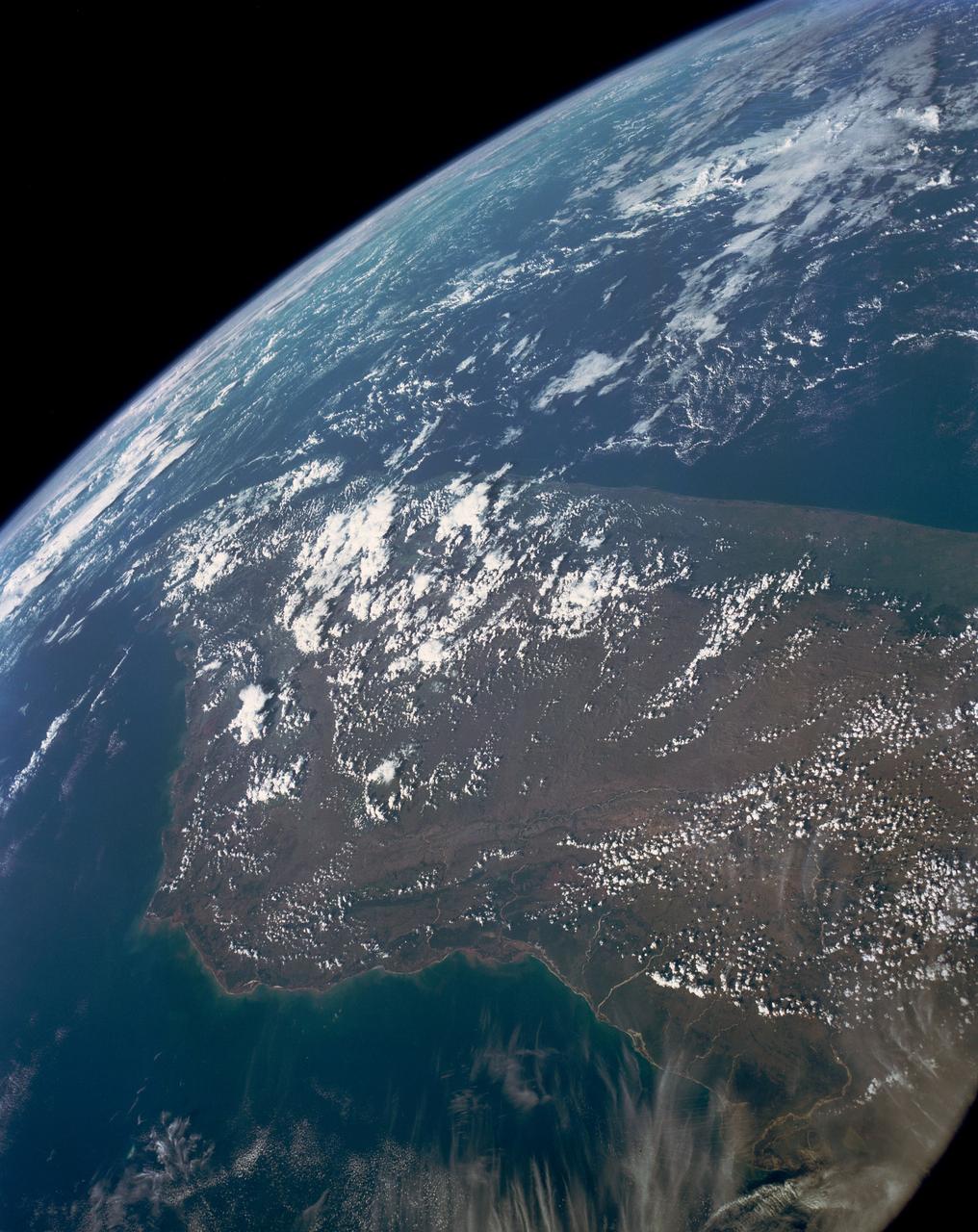
This high oblique view shows the majority of the island of Madagascar (19.0S, 47.5E). This Texas sized island is now largely deforested and is suffering from severe soil erosion as well as a declining biological species diversity and productivity. At the turn of the century, the island was almost totally forested but now, forests cover only about 10 percent of the surface. Evidence of soil erosion can be seen in the offshore sediment plumes.
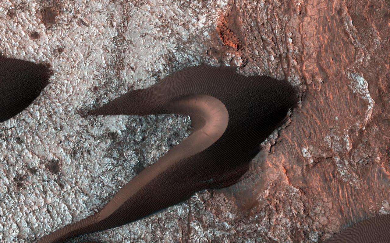
This image from NASA Mars Reconnaissance Orbiter spacecraft provides information about erosion and movement of surface material, about wind and weather patterns, even about the soil grains and grain sizes. However, looking past the dunes, these images also reveal the nature of the substrate beneath. Within the spaces between the dunes, a resistant and highly fractured surface is revealed. The fractured ground is resistant to erosion by the wind, and suggests the material is bedrock that is now shattered by a history of bending stresses or temperature changes, such as cooling, for example. Alternately, the surface may be a sedimentary layer that was once wet and shrunk and fractured as it dried, like gigantic mud cracks. In either case, the relative small and indistinct fractures have trapped the dark dune sand marching overhead. Now the fractures have become quite distinct, allowing us to examine the orientation and spacing of the fractures to learn more about the processes that formed them. http://photojournal.jpl.nasa.gov/catalog/PIA19958
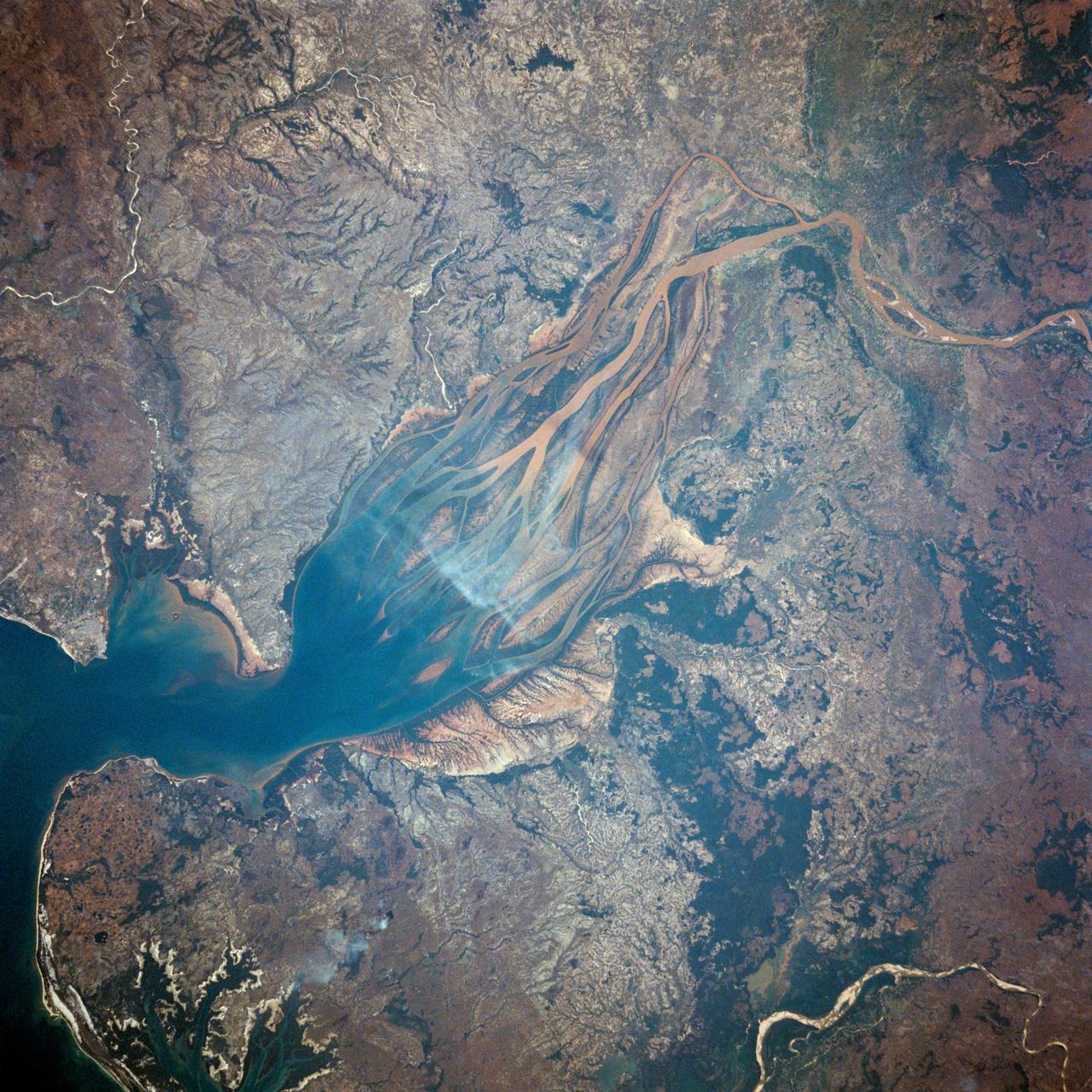
STS007-03-058 (18-24 June 1983) --- The Island of Madagascar in the Indian Ocean off the coast of Africa. The colorful area is the mouth of the Betsiboka River near the city of Majunga. The photograph was taken with a 70mm handheld camera aimed through the aft flight deck?s overhead windows on the Earth-orbiting Space Shuttle Challenger.

This 1970 photograph shows Skylab's Microwave Radiometer/Scatterometer and Altimeter, one of the major components for an Earth Resources Experiment Package (EREP). It was designed to study varying ocean surface, soil erosion, sea and lake ice, snow cover, seasonal vegetational changes, flooding, rainfall and soil types. The overall purpose of the EREP was to test the use of sensors that operated in the visible, infrared, and microwave portions of the electromagnetic spectrum to monitor and study Earth resources. The Marshall Space Flight Center had program management responsibility for the development of Skylab hardware and experiments.
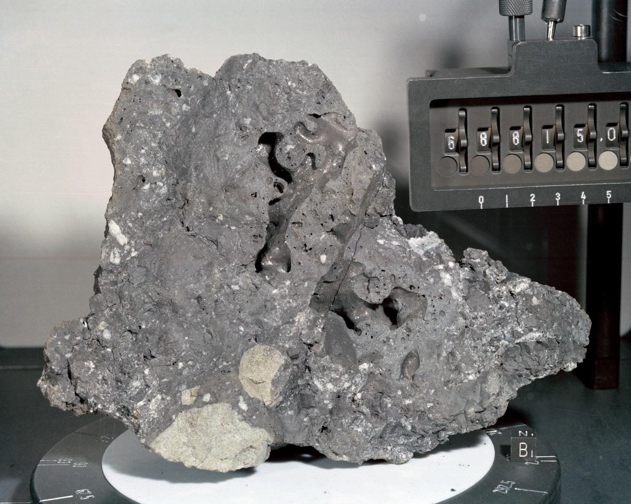
A closeup view or "mug shot" of Apollo 16 lunar sample no. 68815, a dislodged fragment from a parent boulder roughly four feet high and five feet long encountered at Station 8. The crew tried in vain to overturn the parent boulder. A fillet-soil sample was taken close to the boulder, allowing for study of the type and rate of erosion acting on lunar rocks. The fragment itself is very hard, has many veticles and a variety of inclusions. In addition, numerous metallic particles were observed in the black matrix.
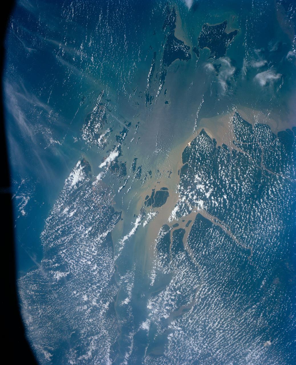
This view shows the area around Northeastern Sumatra, Indonesia (1.0N, 104.0E). The city of Singapore and the Singapore Strait is in the center at the southern tip of the Malay Peninsula. The Singapore Strait is the eastern extension of the Strait of Malacca and separates the Malay Peninsula from Sumatra. Large sediment plumes from the rivers attest to the local soil erosion and industrial dumping ofd wastes.
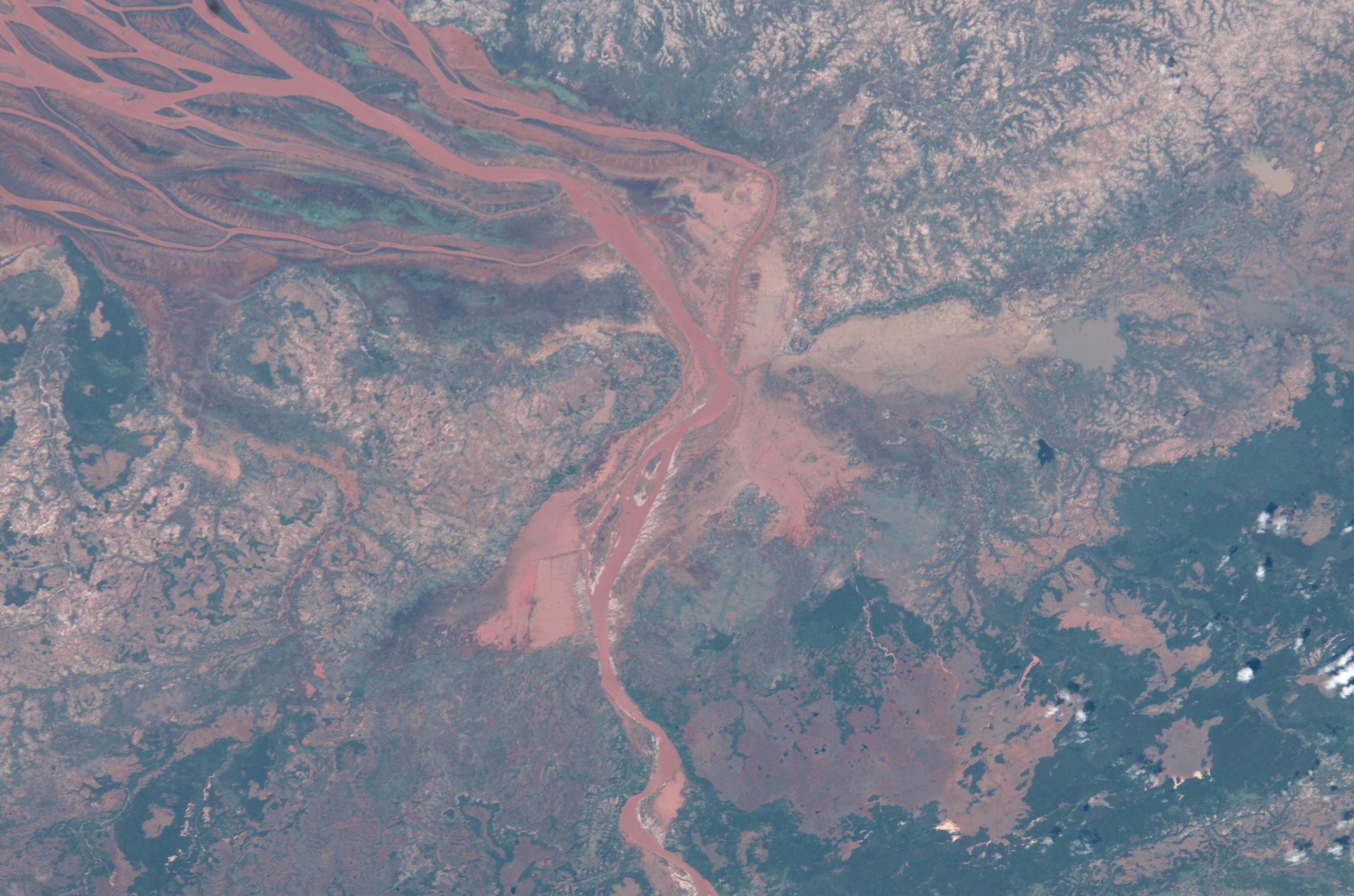
ISS008-E-19236 (25 March 2004) --- This image featuring the Betsiboka estuary on the northwest coast of Madagascar was taken by an Expedition 8 crewmember on the International Space Station (ISS). The Betsiboka estuary is the mouth of Madagascar’s largest river and one of the world’s fast-changing coastlines. Nearly a century of extensive logging of Madagascar’s rainforests and coastal mangroves has resulted in nearly complete clearing of the land and fantastic rates of erosion. After every heavy rain, the bright red soils are washed from the hillsides into the streams and rivers to the coast. Astronauts describe their view of Madagascar as “bleeding into the ocean”. One impact of the extensive 20th century erosion is the filling and clogging of coastal waterways with sediment – a process that is well illustrated in the Betsiboka estuary. In fact, ocean-going ships were once able to travel up the Betsiboka estuary, but must now berth at the coast.
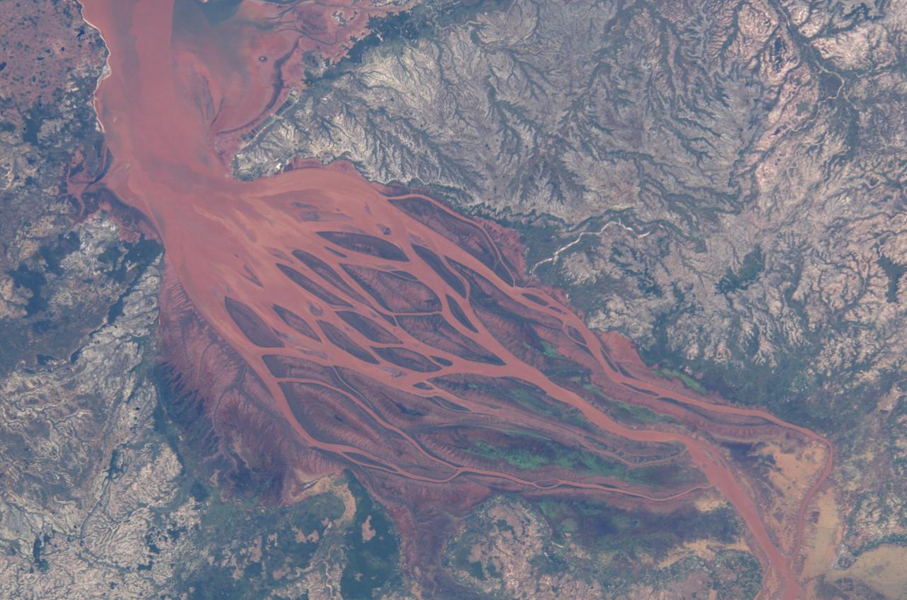
ISS008-E-19233 (25 March 2004) --- This image featuring the Betsiboka estuary on the northwest coast of Madagascar was taken by an Expedition 8 crewmember on the International Space Station (ISS). The Betsiboka estuary is the mouth of Madagascar’s largest river and one of the world’s fast-changing coastlines. Nearly a century of extensive logging of Madagascar’s rainforests and coastal mangroves has resulted in nearly complete clearing of the land and fantastic rates of erosion. After every heavy rain, the bright red soils are washed from the hillsides into the streams and rivers to the coast. Astronauts describe their view of Madagascar as “bleeding into the ocean”. One impact of the extensive 20th century erosion is the filling and clogging of coastal waterways with sediment – a process that is well illustrated in the Betsiboka estuary. In fact, ocean-going ships were once able to travel up the Betsiboka estuary, but must now berth at the coast.
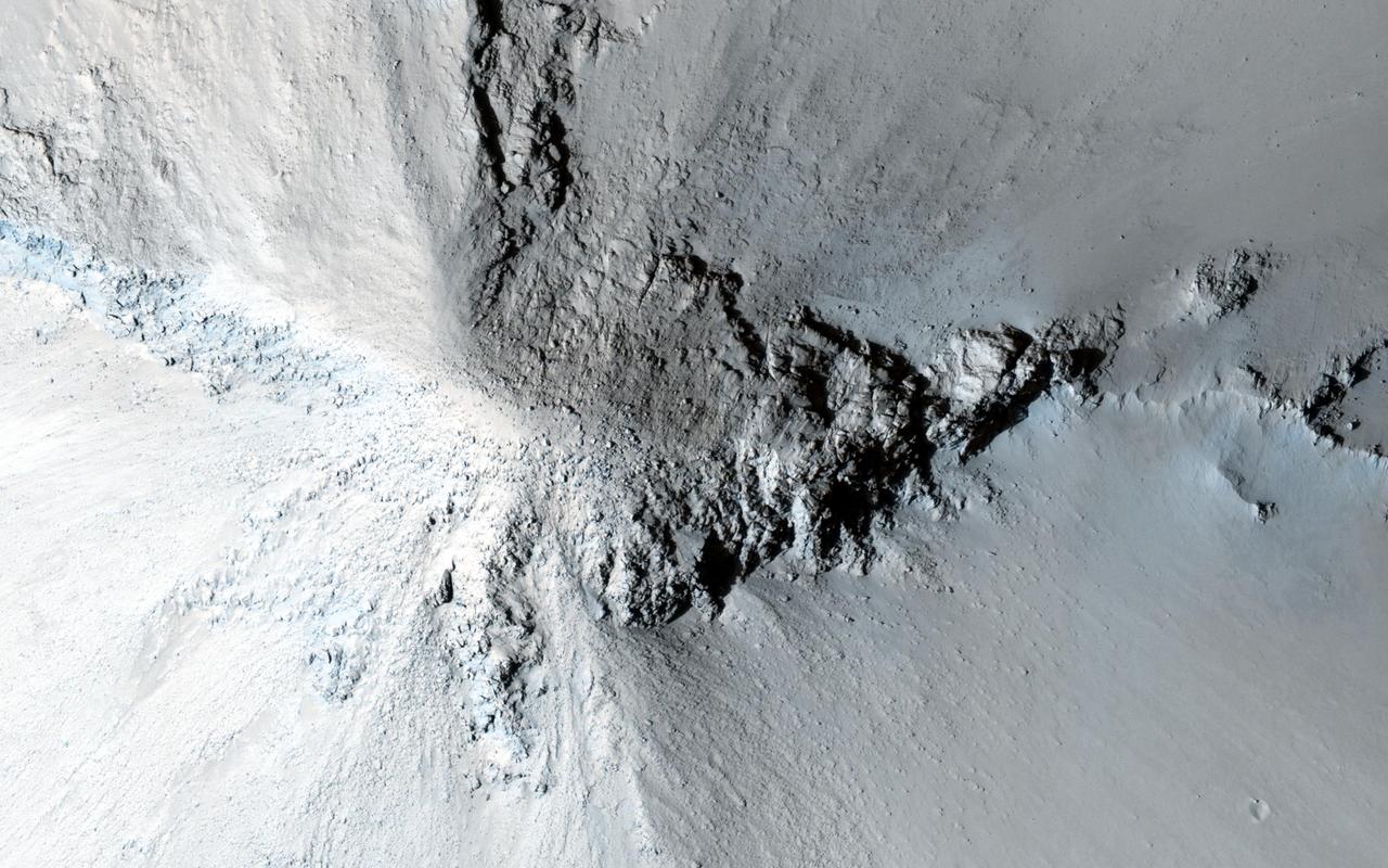
There are many hills and knobs on Mars that reveal aspects of the local geologic history. Typically, the hills in the relatively-smooth region surrounding this image are flat topped erosional remnants or mesas with irregular or even polyhedral margins. These landforms suggest wide spread erosion of the soft or weakly-cemented sedimentary layers. This hill stands out because of is circular inverted-cone shape and apparent dark streaks along its flanks visible in lower resolution images. Close inspection from HiRISE reveals that the fine soils sloping down from the peak are intersected with radiating lines of rock and eroding rubble. This formation is similar to lava intrusions that form in the core of a volcano. As lava is squeezed up into a central conduit, radiating fractures fill with lava forming rock units called dikes. As the lava cools inside the ground and in the fractures, it forms into a harder rock that is more resistant to erosion. Later, as the surrounding sediments and soils erode, the resistant volcanic rock remains standing to tell a story of what happened underground long ago. http://photojournal.jpl.nasa.gov/catalog/PIA20003

S89-E-5328 (27 Jan 1998) --- This Electronic Still Camera (ESC) image shows astronaut James F. Reilly, mission specialist, holding the Mechanics of Granular Materials (MGM) experiment. The MGM experiment is aimed at understanding the behavior of granular materials, such as sand or salt, under very low confining pressure. This pressure is the force that keeps a granular material ?sticking together?. The experiment has applications in a wide range of fields, including earthquake engineering; coastal and off-shore engineering; mining; transportation of granular materials; soil erosion; the handling of granular materials such as grains and powders; off-road vehicles; geology of the Earth; and planetary geology and exploration. Findings from the experiment may lead to improved selection and preparation of building sites, better management of undeveloped land, and improved handling of materials in chemical, agricultural and other industries.
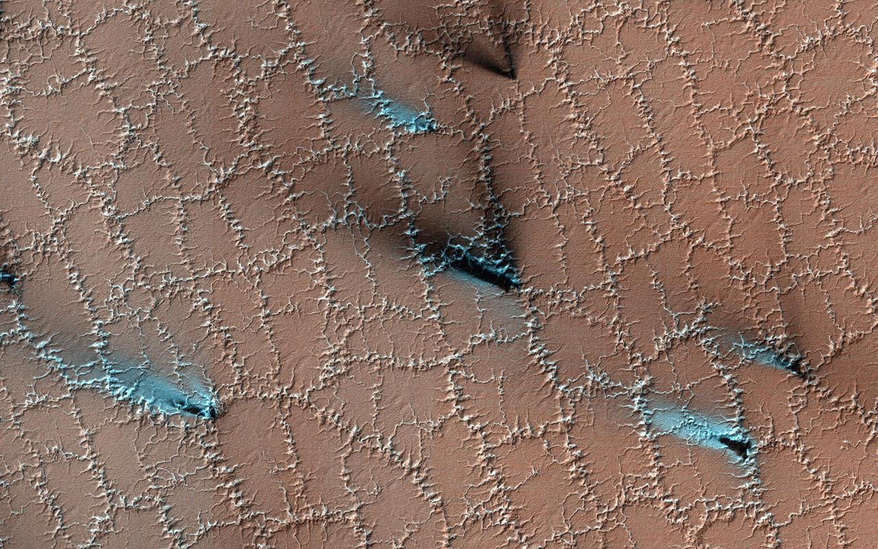
Both water and dry ice have a major role in sculpting Mars' surface at high latitudes. Water ice frozen in the soil splits the ground into polygons. Erosion of the channels forming the boundaries of the polygons by dry ice sublimating in the spring adds plenty of twists and turns to them. Spring activity is visible as the layer of translucent dry ice coating the surface develops vents that allow gas to escape. The gas carries along fine particles of material from the surface further eroding the channels. The particles drop to the surface in dark fan-shaped deposits. Sometimes the dark particles sink into the dry ice, leaving bright marks where the fans were originally deposited. Often the vent closes, then opens again, so we see two or more fans originating from the same spot but oriented in different directions as the wind changes. https://photojournal.jpl.nasa.gov/catalog/PIA25357
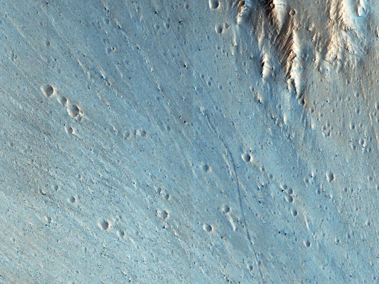
This picture of the rim of Eos Chasma in Valles Marineris shows active erosion of the Martian surface. Layered bedrock is exposed in a steep cliff on a spur of the canyon rim. Dark layers in this cliff are made up of large boulders up to 4 meters in diameter. The boulders are lined up along specific horizons, presumably individual lava flows, and are perched to descend down into the canyon upon the slightest disturbance. How long will the boulders remain poised to fall, and what will push them over the edge? Just as on Earth, the main factors that contribute to dry mass wasting erosion on Mars are frost heaving and thermal expansion and contraction due to changes in temperature. The temperature changes on Mars are extreme compared to Earth, because of the lack of humidity in the Martian atmosphere and the eccentricity of the Martian orbit. Each daily temperature cycle and each seasonal change from summer to winter produces a cycle of expansion and contraction that pushes the boulders gradually closer to the brink. Inevitably, the boulders fall from their precarious positions and plunge into the canyons below. Most simply slide down slope and collect just below the source layers. A few are launched along downward trajectories, travelling long distances before they settle on the slopes below. These trundling boulders left behind conspicuous tracks, up to a kilometer long. The tracks resemble dashed lines or perforations, indicating that the boulders bounced as they trundled down the slopes. The visibility of the boulder tracks suggests that this process may have taken place recently. The active Martian winds quickly erased the tracks of the rover Opportunity, for example. However, the gouges produced by trundling boulders probably go much deeper than the shallow compression of soil by the wheels of a relatively lightweight rover. The boulder tracks might persist for a much longer time span than the rover tracks for this reason. Nevertheless, the tracks of the boulders suggest that erosion of the rim of Eos Chasma is a process that continues today. http://photojournal.jpl.nasa.gov/catalog/PIA21203
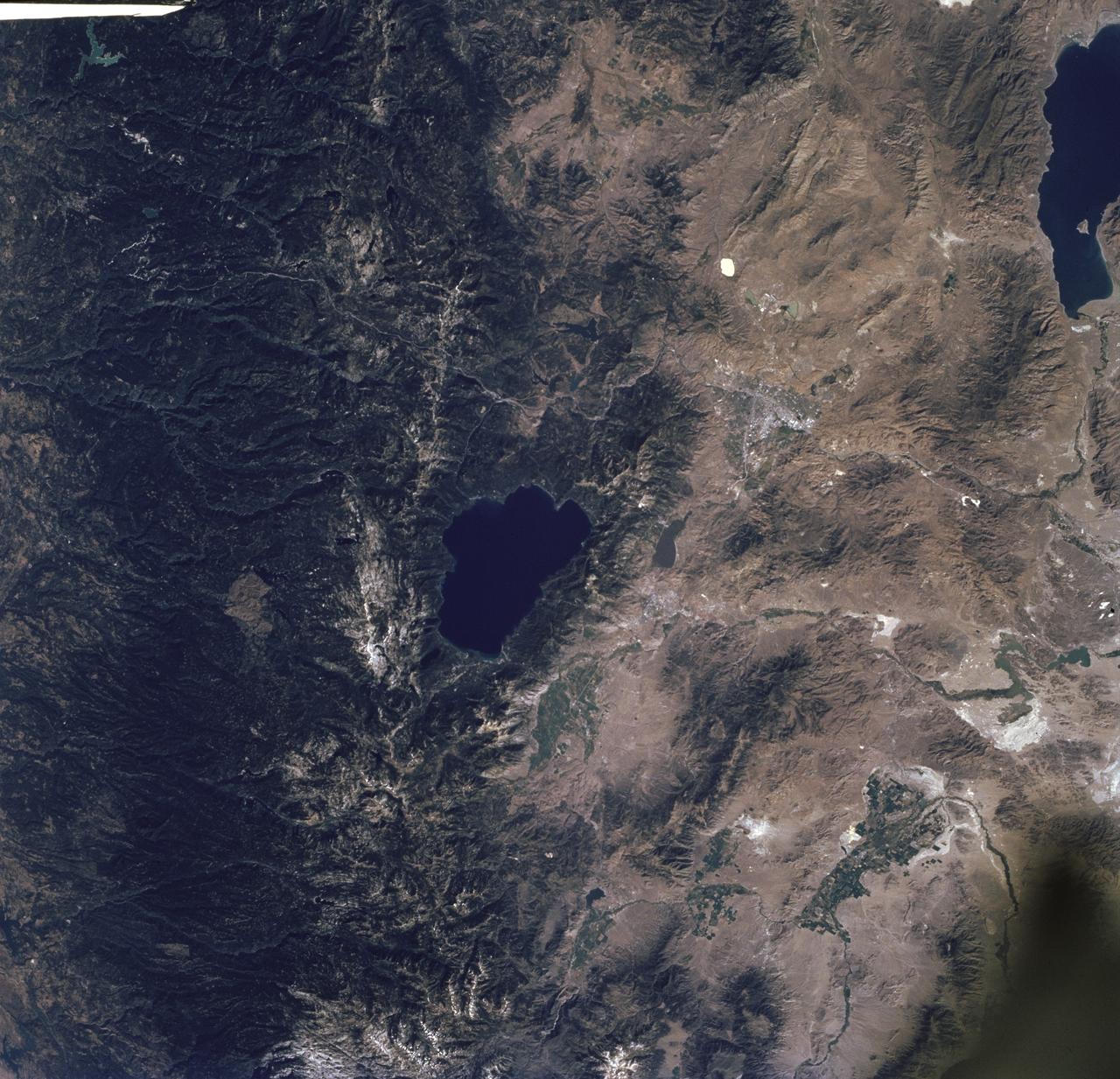
STS085-716-061 (7 - 19 August 1997) --- The dark green forests of the Sierra Nevada Mts. occupy the left side of the picture. Reno lies between Lake Tahoe (center) and Pyramid Lake (top right). Lake Tahoe, is a clear, deep alpine lake (over 505 meters deep), surrounded by Montane forest, ski resorts and casinos. Although Tahoe is known as one of the clearest lakes in the world, water quality in the lake has been declining due to soil erosion from development. Since 1968, it has lost about 30 feet of clarity. A partnership was recently formed between environmentalists and resort owners to protect their common interest in keeping the lake as clear as possible. Over the last five years they have slowed the erosion and the growth of algae that it causes so that clarity is now "only" lost at a rate of roughly one foot per year. Pyramid Lake (on the upper right of the photo) is as different from Tahoe as a lake could be. The sagebrush desert around the lake and is owned by the Pyramid Lake Paiute tribe who manage it as a fishery for an endangered sucker (fish), the cui-cui. The tribe has added modern fisheries' biology methods to their traditional management and chooses not to develop the lake as a recreation destination. Anaho Island, in the lower half of the lake, is a wildlife refuge managed for American White Pelicans which fly hundreds of miles each day to get from this safe breeding area to the shallow marshes where they feed. Directly above Lake Tahoe is Donner pass, near the site where the beleaguered Donner Party spent the winter of 1846 - 1847 trapped in the mountains. Several shallow ephemeral lakes can be seen in Lemmon Valley north of Reno's core urban area. These lakes would normally have dried up by August when this photo was taken, but are still wet because of the extremely wet winter and floods of January 1997.
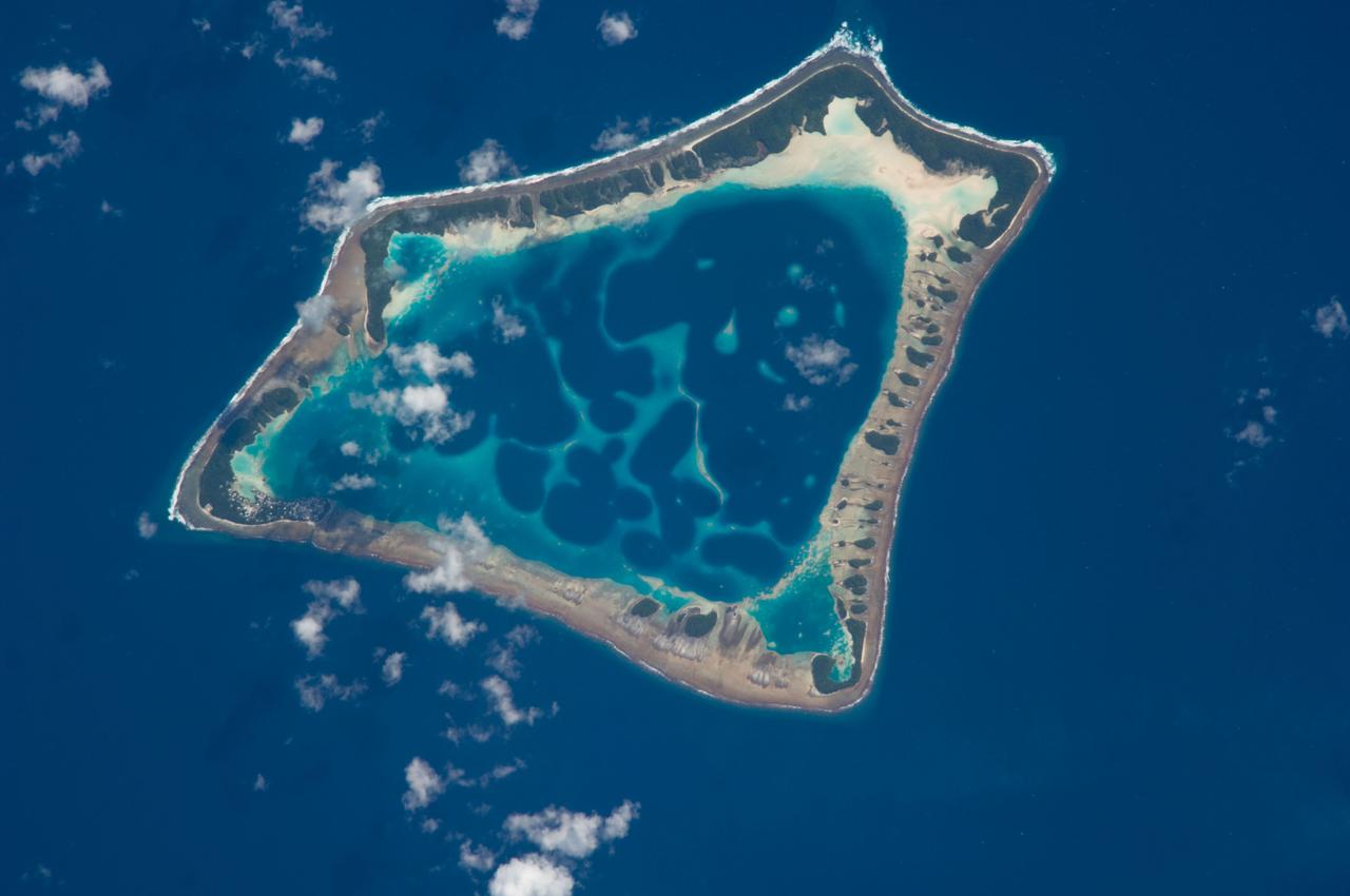
ISS018-E-018129 (6 Jan. 2009) --- Atafu Atoll in the Southern Pacific Ocean is featured in this image photographed by an Expedition 18 crewmember on the International Space Station. At roughly eight kilometers wide, Atafu Atoll is the smallest of three atolls (with Nukunonu and Fakaofo atolls to the southeast, not shown) comprising the Tokelau Islands group located in the southern Pacific Ocean. Swains Island to the south (not shown) is also considered part of the Tokelau group. The political entity of Tokelau is currently a territory of New Zealand. In recent years, public referendums on independence within the islands have been held, but have not received sufficient support to move forward. The primary settlement on Atafu is a village located at the northwestern corner of the atoll ? indicated by an area of light gray dots in this photograph. The typical ring shape of the atoll is the result of coral reefs building up around a former volcanic island. Over geologic time, the central volcano has subsided beneath the water surface, leaving the fringing reefs and a central lagoon that contains submerged coral reefs. Erosion and soil development on the surfaces of the exposed fringing reefs has lead to formation of tan to light brown beach deposits (southern and western sides of the atoll) and green vegetation cover (northern and eastern sides of the atoll). The Tokelau Islands, including Atafu Atoll, suffered significant inundation and erosion during Tropical Cyclone Percy in 2005. The approximate elevation of Atafu Atoll is only two meters above the tidal high water level. Vulnerability to tropical cyclones and potential sea level rise makes the long-term habitability of the atoll uncertain.
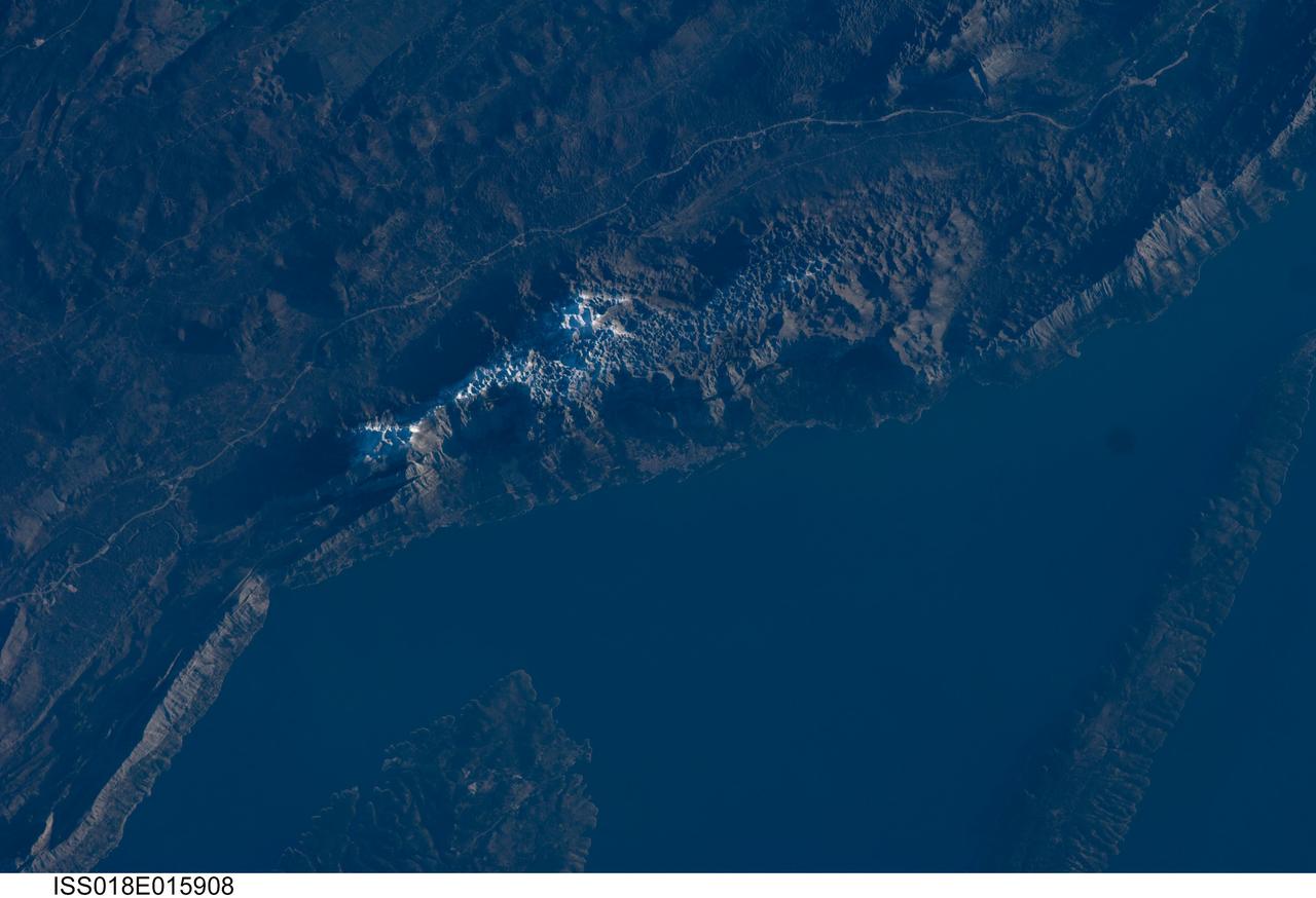
ISS018-E-015908 (29 Dec. 2008) --- The Biokovo Range in Croatia is featured in this image photographed by an Expedition 18 crewmember on the International Space Station. The Biokovo Range in Croatia is part of the Dinaric Alps extending northwest-southeast along the coastline of the Adriatic Sea. The Range itself is the location of a national park; the nearby city of Makarska, located between the mountains and the sea, is a popular tourist destination. The highest peak in the Biokovo Range, Sveti Jure (1762 meters above sea level), is reachable by road or hiking. The Range is comprised mainly of Mesozoic age carbonate rocks ? primarily limestone, a sedimentary rock type rich in calcium carbonate ? deposited in relatively warm, shallow waters. Later tectonic processes uplifted and exposed the carbonate rocks to erosion ? leading to a distinctive geological surface known as karst topography. Karst topography originates due to the chemical erosion of carbonate rocks by acids formed in surface and subsurface water; as the rock is dissolved, underground networks of drainages and caves form. As more underground void space develops through time, the overlaying rock and soil collapses to form a variety of landforms including sinkholes, blind valleys, and towers. In the Biokovo Range, much of the karst surface has a pitted appearance, made easily visible by early morning light in this astronaut photograph. The pitted appearance is produced by numerous circular or semi-circular collapse valleys known locally as vrtace. While this image captures Sveti Jure covered with snow, there are no glaciers or ice fields in the Biokovo Range.
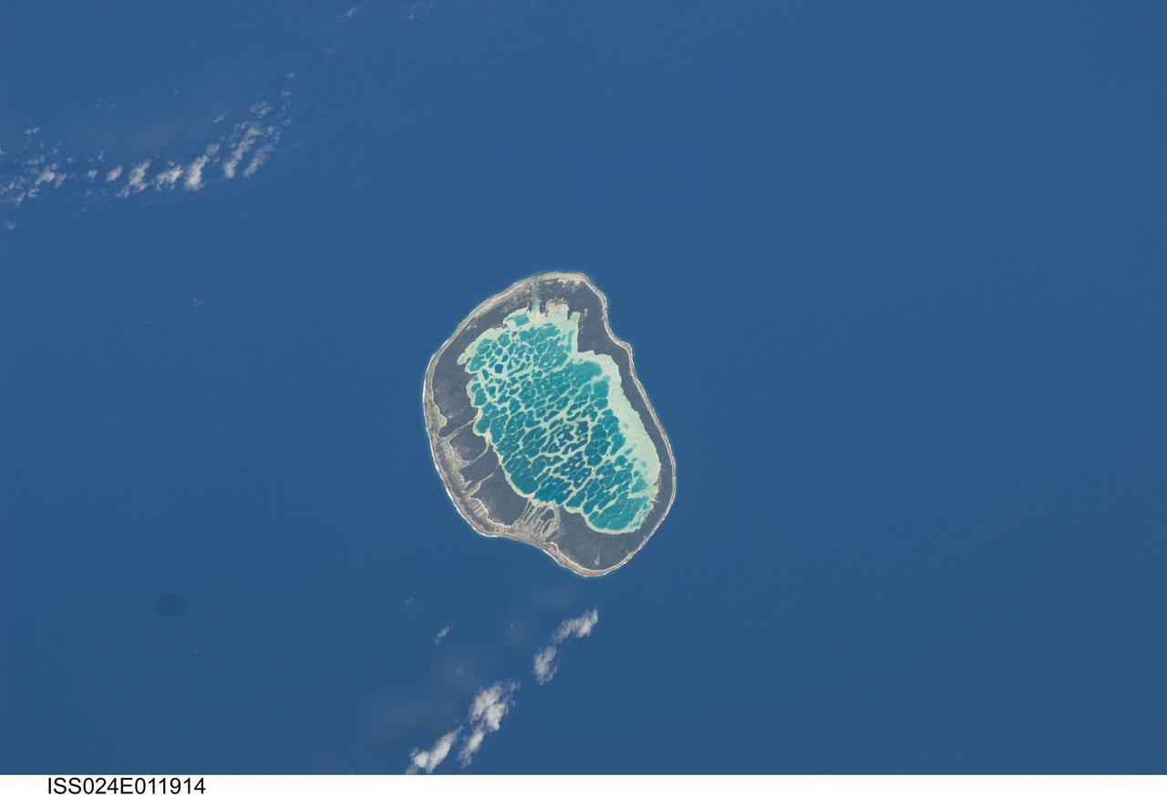
ISS024-E-011914 (13 Aug. 2010) --- Mataiva Atoll, Tuamotu Archipelago in the South Pacific Ocean is featured in this image photographed by an Expedition 24 crew member on the International Space Station. The Tuamotu Archipelago is part of French Polynesia, and forms the largest chain of atolls in the world. This photograph features Mataiva Atoll, the westernmost atoll of the Tuamotu chain. An atoll is a ring-shaped island that encloses a central lagoon. This distinctive morphology is usually associated with oceanic islands formed by volcanoes; coral reefs become established around the partially submerged volcanic cone. Over geologic time the central volcano becomes extinct, followed by erosion and subsidence beneath the sea surface, leaving the coral reefs as a ring around (or cap on) the submerged island remnant. Coral reefs exposed above the sea surface in turn experience erosion, sedimentation and soil formation, leading to the establishment of vegetation and complex ecosystems – including in many cases human habitation. Mataiva Atoll is notable in that its central lagoon includes a network of ridges (white, center) and small basins formed from eroded coral reefs. Mataiva means “nine eyes” in Tuamotuan, an allusion to nine narrow channels on the south-central portion of the island. The atoll is sparsely populated, with only a single village – Pahua – located on either side of the only pass providing constant connection between the shallow (light blue) water of the lagoon and the deeper (dark blue) adjacent Pacific Ocean. Much of the 10 kilometer-long atoll is covered with forest (greenish brown); vanilla and copra (dried coconut) are major exports from the atoll, but tourism is becoming a greater economic factor.
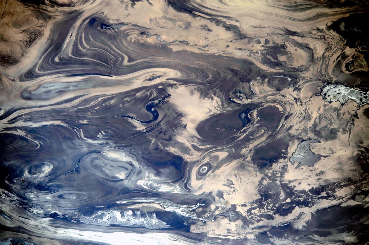
ISS038-E-047388 (14 Feb. 2014) --- As the International Space Station passed over the deserts of central Iran, including Kavir, one of the Expedition 38 crew members used a digital camera equipped with a 200mm lens to record this image featuring an unusual pattern of numerous parallel lines and sweeping curves. The lack of soil and vegetation allows the geological structure of the rocks to appear quite clearly. According to geologists, the patterns result from the gentle folding of numerous, thin, light and dark layers of rock. Later erosion by wind and water, say the scientists, cut a flat surface across the folds, not only exposing hundreds of layers but also showing the shapes of the folds. The dark water of a lake (image center) occupies a depression in a more easily eroded, S-shaped layer of rock. The irregular light-toned patch just left of the lake is a sand sheet thin enough to allow the underlying rock layers to be detected. A small river snakes across the bottom of the image. In this desert landscape there are no fields or roads to give a sense of scale. In fact, the image width represents a distance of 65 kilometers.
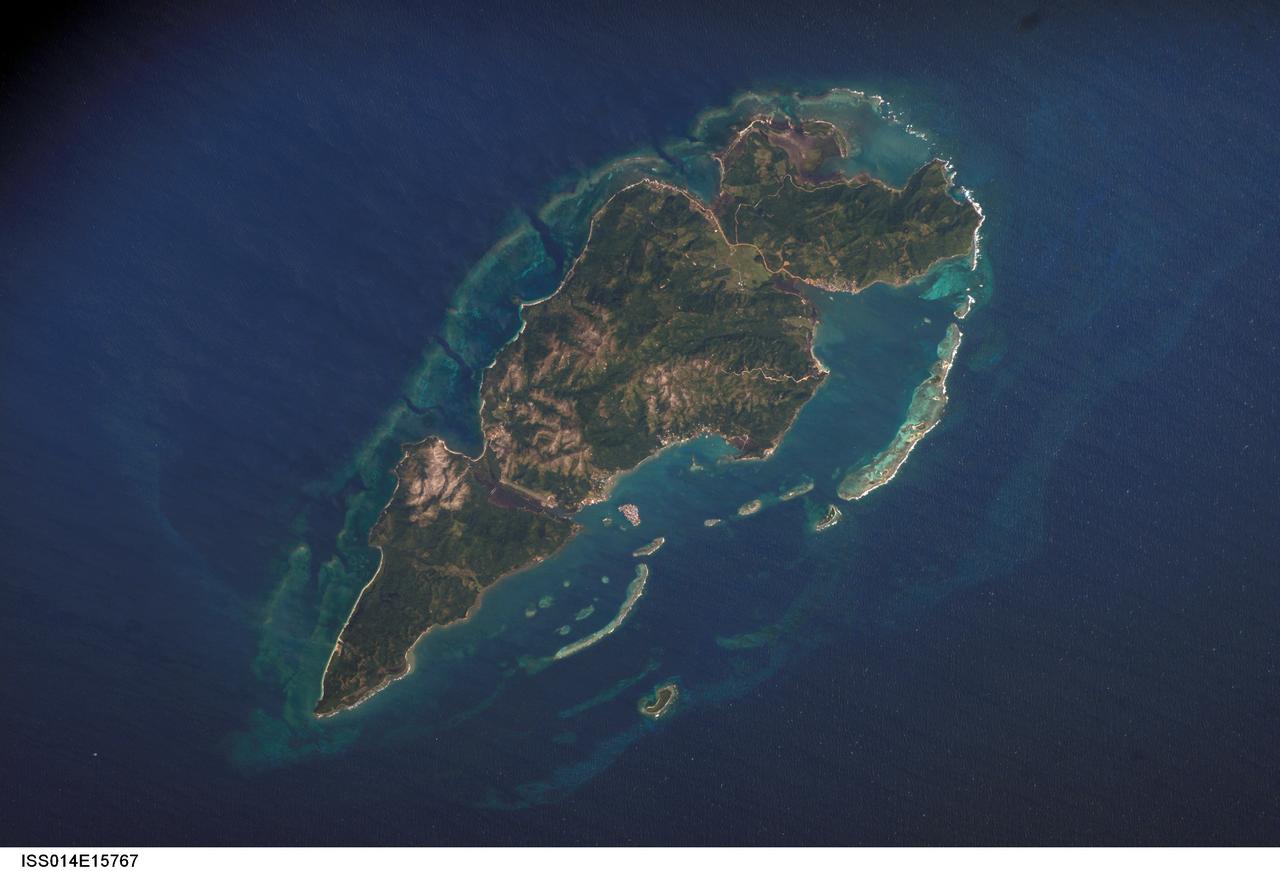
ISS014-E-15767 (1 March 2007) --- Guanaja Island, Honduras is featured in this image photographed by an Expedition 14 crewmember on the International Space Station. Guanaja Island is located along the southwestern margin of the Gulf of Mexico, approximately 60 kilometers north of mainland Honduras. The island is situated near the western edge of the Cayman Ridge, a topographic feature comprised of rock types indicative of ancient volcanic islands, sedimentary layers, and ocean crust. The Ridge formed as a result of tectonic interactions between the North American, South American, and Caribbean Plates. Guanaja and the nearby islands of Roatan and Utila (not shown) comprise the only portions of the western Cayman Ridge currently exposed above water. The island is also notable for its largely undeveloped character -- the exception being highly concentrated development on Bonacca Cay, a small island (roughly 0.5 kilometers by 0.3 kilometers) located along the southeastern coastline of the main island. The main island has little in the way of roads or other infrastructure -- a canal is the major means of traversing the island - making it an attractive destination for hikers and eco-tourists. The clear waters and reefs that almost completely encircle Guanaja also attract divers. In 1998, hurricane Mitch destroyed almost all (97 percent) of the island's mangrove forests, impacting coastal habitats and resulting in soil erosion. Regeneration of mangroves is slow and active reseeding efforts have been suggested as the only means to restore the forests.
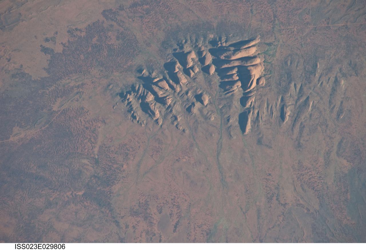
ISS023-E-029806 (30 April 2010) --- Kata Tjuta, Australia is featured in this image photographed by an Expedition 23 crew member on the International Space Station. Located in the Northern Territory of Australia, Uluru – Kata Tjuta National Park hosts some of the world’s most spectacular examples of inselbergs, or isolated mountains. The most famous of these inselbergs is Uluru (also known as Ayers Rock). An equally massive inselberg located approximately 30 kilometers to the northwest is known as Kata Tjuta– like Uluru, this is a sacred site to the native Anangu or Aboriginal people. Explorers named the highest peak Mount Olga, with the entire grouping of rocks informally known as “the Olgas”. Mount Olga has a peak elevation of 1,069 meters above sea level, making it 206 meters higher than Uluru. Kata Tjuta is comprised of gently dipping Mount Currie Conglomerate, a sedimentary rock that includes abundant rounded fragments of other rock types (here, primarily granite with less abundant basalt and rhyolite) in a coarse sandy matrix. Geologists interpret the Mount Currie Conglomerate as a remnant of a large fan of material rapidly eroded from mountains uplifted approximately 550 million years ago. Subsequent burial under younger sediments consolidated the eroded materials to form the conglomerate exposed at the surface today. In this photograph, afternoon sunlight highlights the rounded summits of Kata Tjuta against the surrounding sandy plains. Sand dunes are visible at upper right; while in other areas (image top and image left) sediments washed from the rocks have been anchored by a variety of grasses and bushes adapted to the arid climate. Green vegetation in the ephemeral stream channels that drain Kata Tjuta (bottom center) provides colorful contrast with the red rocks and surrounding soils. Large gaps in the rocks (highlighted by shadows) are thought to be fractures that have been enlarged due to erosion.
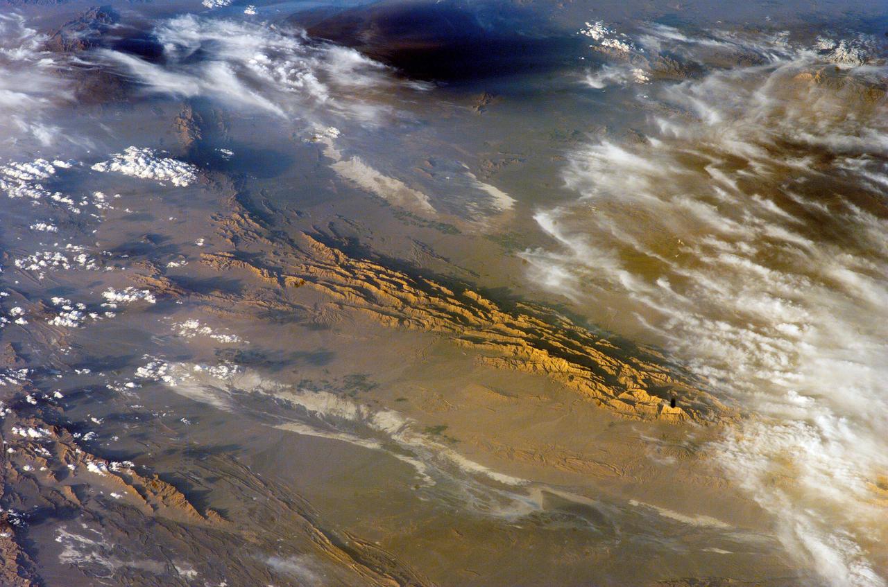
ISS012-E-18779 (28 Feb. 2006) --- Winter in the Dasht-e-Lut Desert, eastern Iran is featured in this image photographed by an Expedition 12 crew member on the International Space Station. The image takes advantage of the low angle of illumination to reveal linear geological structures of the Iranian mountain range bordering the western edge of the basin known as Dasht-e-Lut. The range rises 1818 meters (6000 feet) above sea level and lies 750 kilometers (466 miles) north of the Persian Gulf. The convoluted appearance results from erosion of folded and faulted rocks – softer rocks erode away quickly, leaving more resistant rock to form linear ridges perpendicular to the direction of compression. While not a major oil producing region like the Zagros Fold Belt to the southwest, the mountains of east-central Iran contain economically important deposits of copper and other metals. Little vegetation is visible from space in the arid interior basin of the Dasht-e-Lut. Iran is climatically part of the Afro-Asian belt of deserts that stretch from the Cape Verde islands off West Africa all the way to Mongolia near Beijing. The patchy, elongated, light-colored feature in the foreground (parallel to the mountain range) is the northernmost of the Dasht dry lakes that stretch southward 300 kilometers (186 miles). High country is the source of precipitation-derived water in all near-tropical deserts. Agricultural fields (small dark patches in the image) that depend on this precipitation are located down slope near the margin of the dry, salty soils of the lake.

ISS013-E-74843 (2 Sept. 2006) --- Rio Negro in Amazonia, Brazil is featured in this image photographed by an Expedition 13 crewmember onboard the International Space Station. The wide, multi-island zone in the Rio Negro (Black River) shown in this image is one of two, long "archipelagoes" upstream of the city of Manaus (not shown) in central Amazonia. Ninety kilometers of the total 120 kilometers length of this archipelago appear in this view. On the day the photo was taken, air temperatures over the cooler river water of the archipelago were just low enough to prevent cloud formation. Over the neighboring rainforest, temperatures were warm enough to produce small convection-related clouds, known to pilots as "popcorn" cumulus. Several zones of deforestation, represented by lighter green zones along the river banks, are also visible. Two different types of river appear in this image. Flowing east-southeast (left to right) is the multi-island, Rio Negro, 20 kilometers wide near the right of the view. Two other "black" rivers, Rio Caures and Rio Jufari, join Rio Negro downstream. The second river type is the Rio Branco (White River; right) which is the largest tributary of the Rio Negro. The difference in water color is controlled by the source regions: black-water rivers derive entirely from soils of lowland forests. Water in these rivers has the color of weak tea, which appears black in images from space. By contrast, white-water rivers like the Branco carry a load of sand and mud particles, mudding the waters. The reason for the tan color is that white-water rivers rise in mountainous country where headwater streams erode exposed rock. The Amazon itself rises in the Andes Mts., where very high erosion occurs, and it is thus the most famous white river in Amazonia. This image was taken in September, near low-water stage. Pictures taken at other times show the channels much wider during high-water season (May--July) when water levels rise several meters. It was discovered recently, from high resolution GPS measurements at Manaus, that the land surface actually rises vertically a small amount in compensation when this vast mass of water drains away each season. Although small, the vertical displacement--50-70 mm--was unexpectedly large according to the scientists who performed the study.
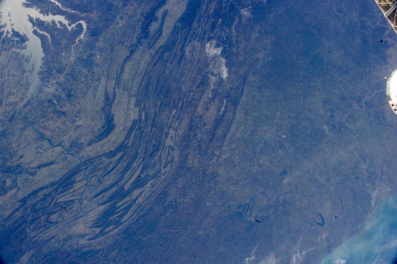
ISS033-E-022378 (17 Nov. 2012) --- The Appalachian Mountains in the eastern Unites States are featured in this image photographed by an Expedition 33 crew member on the International Space Station. This regional view shows the striking visual effect of the valley-and-ridge topography of the Appalachian Mountains as viewed from orbit. The view shows more than 300 miles (500 kilometers) of this low mountain chain, from northeast Pennsylvania (lower left) to southern West Virginia, where a dusting of snow can be seen (top center). Sunglint reflections reveal detail of Chesapeake Bay and the great bend of the Potomac River. Cities are difficult to detect from space during daylight hours, so the sickle-shaped bend of the river is a good visual guide for station crew members trying to photograph the nation?s capital, Washington D.C. (upper left). The farm-dominated Piedmont Plateau is the light-toned area between the mountains and the bay. The Appalachian Mountains appear striped because the ridges are forested; providing a dense and dark canopy cover, while the valleys are farmed with crops that generally appear as lighter-toned areas. Geologically the valleys are the softer, more erodible rock layers, much the preferred places for human settlement. Not only do the larger rivers occupy the valley floors, but all the larger rivers flow in them, soils are thicker, slopes are gentle, and valleys are better protected from winter winds. According to scientists, rocks that form the valley-and-ridge province, as it is known, are relatively old (540-300 million years old), and were laid down in horizontal layers when North America was attached to Europe as the ancient supercontinent of Laurasia. During this time Gondwanaland ? an ancient supercontinent that included present-day Africa, India, South America, Australia and Antarctica - was approaching Laurasia under the influence of plate tectonics. The northwest coastline of modern Africa was the section of Gondwanaland that ?bumped up? against modern North America over a long period (320 ? 260 million years ago), according to scientists. The net result of the tectonic collision was the building of a major mountain chain, much higher than the present Appalachian range?in the process of which the flat-lying rock layers were crumpled up into a series of tight folds, at right angles to the advance of Gondwanaland. The collision also formed the singular supercontinent of Pangaea. The scientists say that, over the following 200 million years, Pangaea broke apart; the modern Atlantic Ocean formed; and erosion wore down the high mountains. What is left to see are the coastline of North America, and the eroded stumps of the mountain chain as the relatively low, but visually striking present-day Appalachian Mountains.