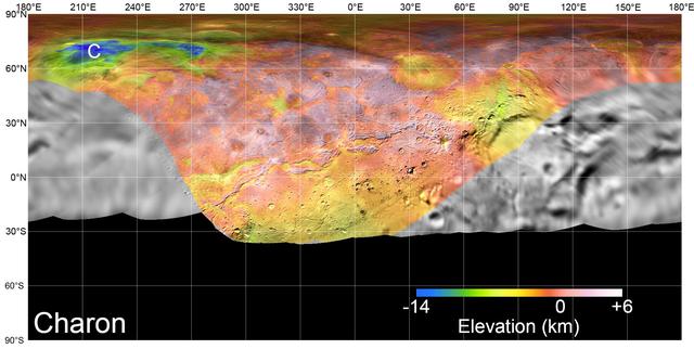
On July 14, 2015, NASA's New Horizons spacecraft made its historic flight through the Pluto system. This detailed, high-quality global mosaic of Pluto's largest moon, Charon, was assembled from nearly all of the highest-resolution images obtained by the Long-Range Reconnaissance Imager (LORRI) and the Multispectral Visible Imaging Camera (MVIC) on New Horizons. The mosaic is the most detailed and comprehensive global view yet of Charon's surface using New Horizons data. It includes topography data of the hemisphere visible to New Horizons during the spacecraft's closest approach. The topography is derived from digital stereo-image mapping tools that measure the parallax -- or the difference in the apparent relative positions -- of features on the surface obtained at different viewing angles during the encounter. Scientists use these parallax displacements of high and low terrain to estimate landform heights. The global mosaic has been overlain with transparent, colorized topography data wherever on the surface stereo data is available. Terrain south of about 30°S was in darkness leading up to and during the flyby, so is shown in black. All feature names on Pluto and Charon are informal. The global mosaic has been overlain with transparent, colorized topography data wherever on their surfaces stereo data is available. Standing out on Charon is the Caleuche Chasma ("C") in the far north, an enormous trough at least 350 kilometers (nearly 220 miles) long, and reaching 14 kilometers (8.5 miles) deep -- more than seven times as deep as the Grand Canyon. https://photojournal.jpl.nasa.gov/catalog/PIA21860
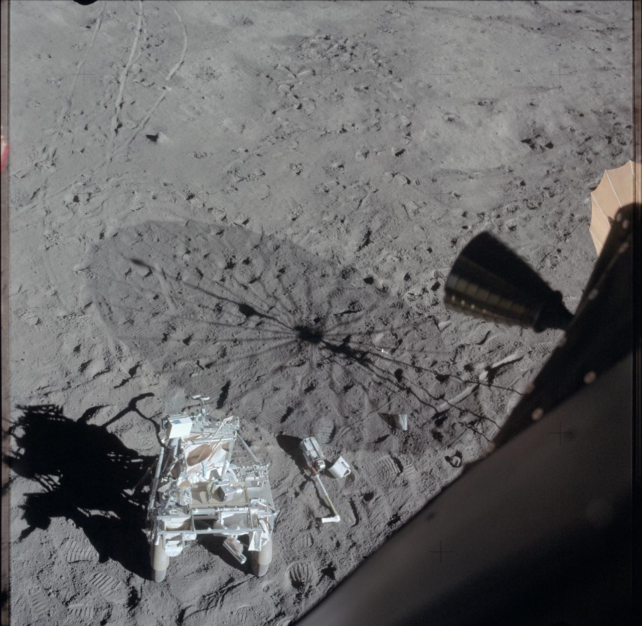
AS14-66-9340 (6 Feb. 1971) --- A view from inside the Lunar Module (LM) following the second Apollo 14 extravehicular activity (EVA). At the left foreground is the modularized equipment transporter (MET). Tracks made by the two-wheeled "Rickshaw"-type cart can be seen in the left background. The Apollo 35mm stereo close-up camera lies next to the MET, near a huge shadow of the erectable S-Band antenna. The area is largely covered with bootprints made by astronauts Alan B. Shepard Jr., commander, and Edgar D. Mitchell, lunar module pilot. While the pair explored the moon, astronaut Stuart A. Roosa, command module pilot, remained with the Command and Service Modules (CSM) in lunar orbit.
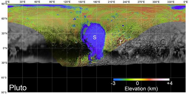
On July 14, 2015, NASA's New Horizons spacecraft made its historic flight through the Pluto system. This detailed, high-quality global mosaic of Pluto was assembled from nearly all of the highest-resolution images obtained by the Long-Range Reconnaissance Imager (LORRI) and the Multispectral Visible Imaging Camera (MVIC) on New Horizons. The mosaic is the most detailed and comprehensive global view yet of Pluto's surface using New Horizons data. It includes topography data of the hemisphere visible to New Horizons during the spacecraft's closest approach. The topography is derived from digital stereo-image mapping tools that measure the parallax -- or the difference in the apparent relative positions -- of features on the surface obtained at different viewing angles during the encounter. Scientists use these parallax displacements of high and low terrain to estimate landform heights. The global mosaic has been overlain with transparent, colorized topography data wherever on the surface stereo data is available. Terrain south of about 30°S was in darkness leading up to and during the flyby, so is shown in black. Examples of large-scale topographic features on Pluto include the vast expanse of very flat, low-elevation nitrogen ice plains of Sputnik Planitia ("P") -- note that all feature names in the Pluto system are informal -- and, on the eastern edge of the encounter hemisphere, the aligned, high-elevation ridges of Tartarus Dorsa ("T") that host the enigmatic bladed terrain, mountains, possible cryovolcanos, canyons, craters and more. https://photojournal.jpl.nasa.gov/catalog/PIA21861
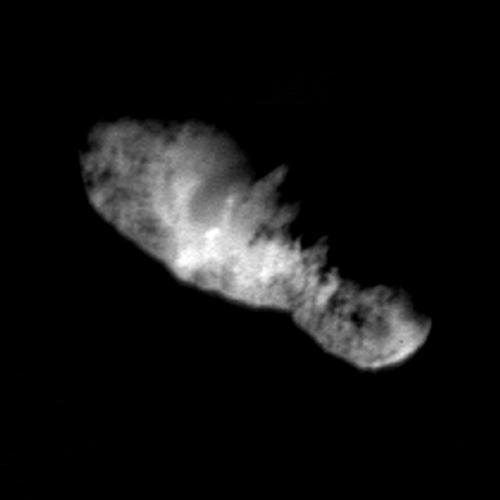
In this highest resolution view of the icy, rocky nucleus of comet Borrelly, (about 45 meters or 150 feet per pixel) a variety of terrains and surface textures, mountains and fault structures, and darkened material are visible over the nucleus's surface. This was the final image of the nucleus of comet Borrelly, taken just 160 seconds before Deep Space1's closest approach to it. This image shows the 8-km (5-mile) long nucleus about 3417 kilometers (over 2,000 miles) away. Smooth, rolling plains containing brighter regions are present in the middle of the nucleus and seem to be the source of dust jets seen in the coma. The rugged land found at both ends of the nucleus has many high ridges along the jagged line between day and night on the comet. This rough terrain contains very dark patches that appear to be elevated compared to surrounding areas. In some places the dark material accentuates grooves and apparent faults. Stereo analysis shows the smaller end of the nucleus (lower right) is tipped toward the viewer (out of frame). Sunlight is coming from the bottom of the frame. http://photojournal.jpl.nasa.gov/catalog/PIA03500
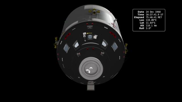
In December of 1968, the crew of Apollo 8 became the first people to leave our home planet and travel to another body in space. But as crew members Frank Borman, James Lovell, and William Anders all later recalled, the most important thing they discovered was Earth. Using photo mosaics and elevation data from Lunar Reconnaissance Orbiter (LRO), this video commemorates the 45th anniversary of Apollo 8's historic flight by recreating the moment when the crew first saw and photographed the Earth rising from behind the Moon. Narrator Andrew Chaikin, author of A Man on the Moon, sets the scene for a three-minute visualization of the view from both inside and outside the spacecraft accompanied by the onboard audio of the astronauts. The visualization draws on numerous historical sources, including the actual cloud pattern on Earth from the ESSA-7 satellite and dozens of photographs taken by Apollo 8, and it reveals new, historically significant information about the Earthrise photographs. It has not been widely known, for example, that the spacecraft was rolling when the photos were taken, and that it was this roll that brought the Earth into view. The visualization establishes the precise timing of the roll and, for the first time ever, identifies which window each photograph was taken from. The key to the new work is a set of vertical stereo photographs taken by a camera mounted in the Command Module's rendezvous window and pointing straight down onto the lunar surface. It automatically photographed the surface every 20 seconds. By registering each photograph to a model of the terrain based on LRO data, the orientation of the spacecraft can be precisely determined. Credit: NASA's Scientific Visualization Studio <b><a href="http://www.nasa.gov/audience/formedia/features/MP_Photo_Guidelines.html" rel="nofollow">NASA image use policy.</a></b> <b><a href="http://www.nasa.gov/centers/goddard/home/index.html" rel="nofollow">NASA Goddard Space Flight Center</a></b> enables NASA’s mission through four scientific endeavors: Earth Science, Heliophysics, Solar System Exploration, and Astrophysics. Goddard plays a leading role in NASA’s accomplishments by contributing compelling scientific knowledge to advance the Agency’s mission. <b>Follow us on <a href="http://twitter.com/NASA_GoddardPix" rel="nofollow">Twitter</a></b> <b>Like us on <a href="http://www.facebook.com/pages/Greenbelt-MD/NASA-Goddard/395013845897?ref=tsd" rel="nofollow">Facebook</a></b> <b>Find us on <a href="http://instagram.com/nasagoddard?vm=grid" rel="nofollow">Instagram</a></b>