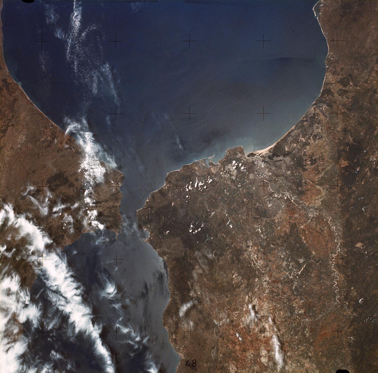
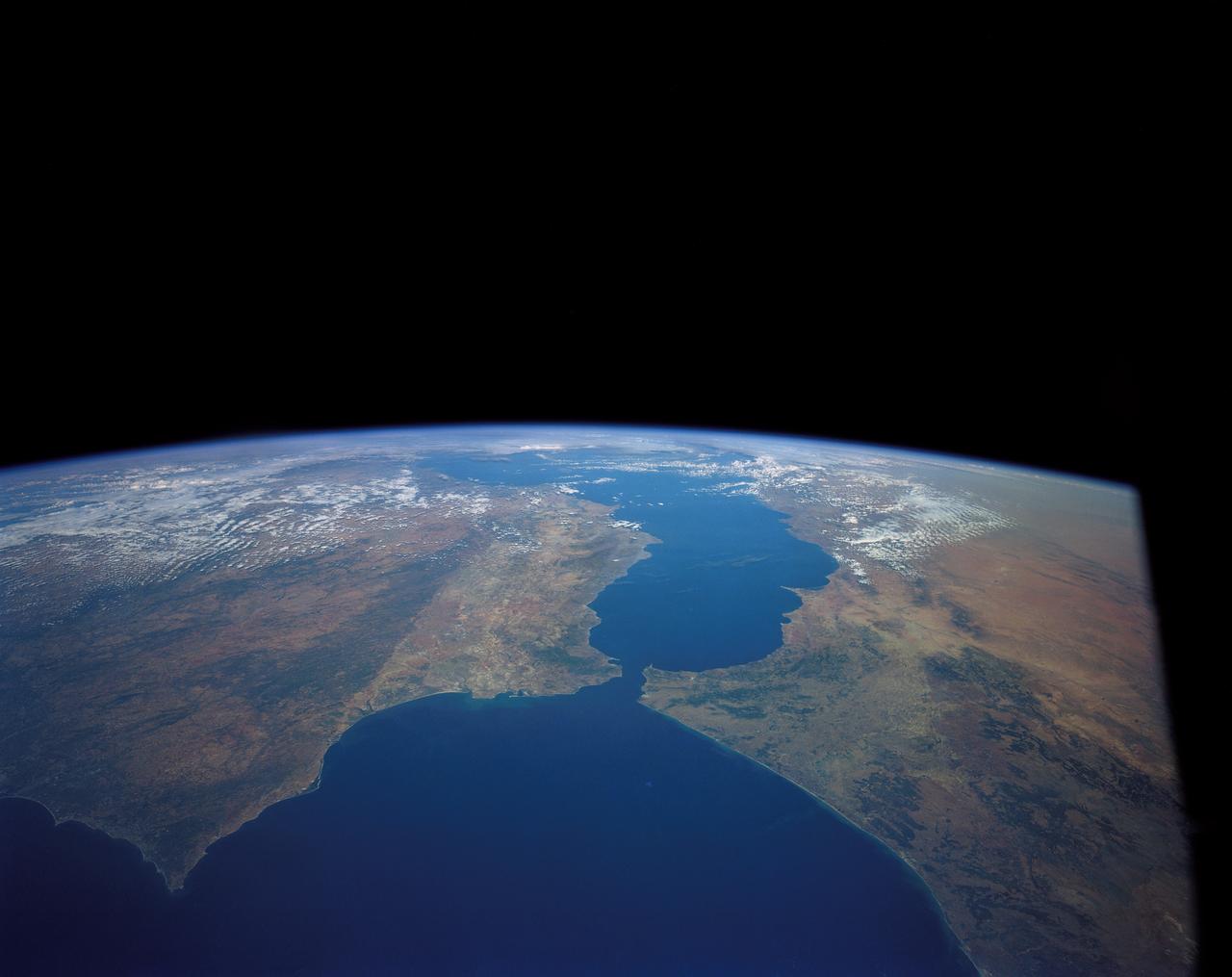
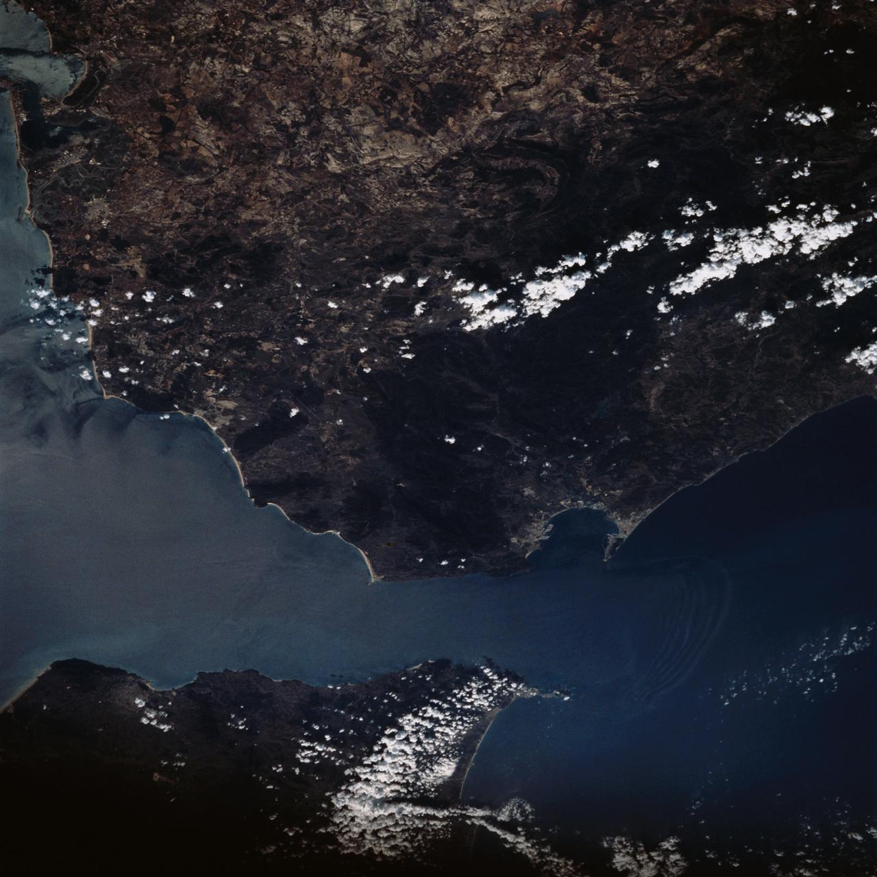
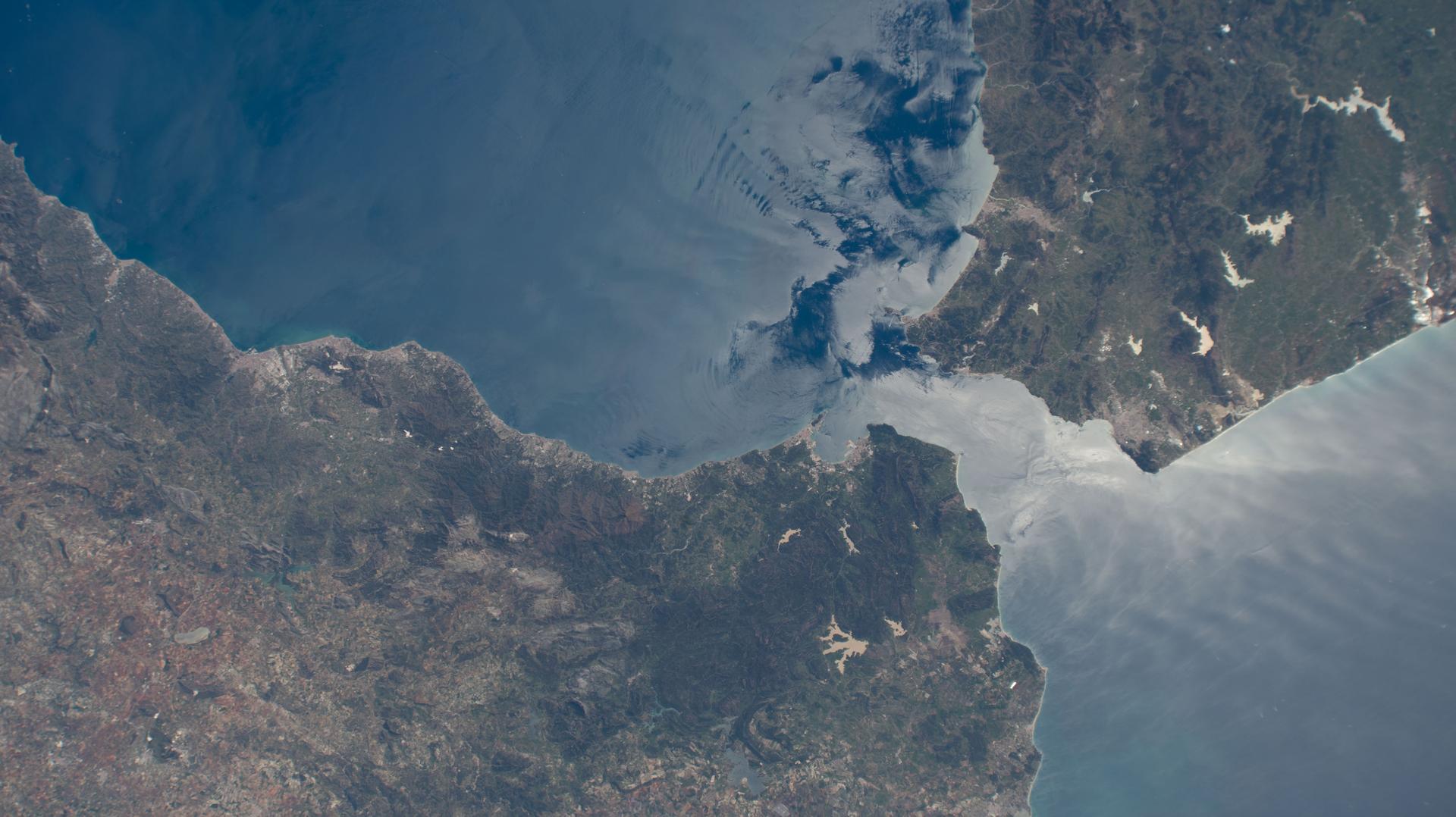
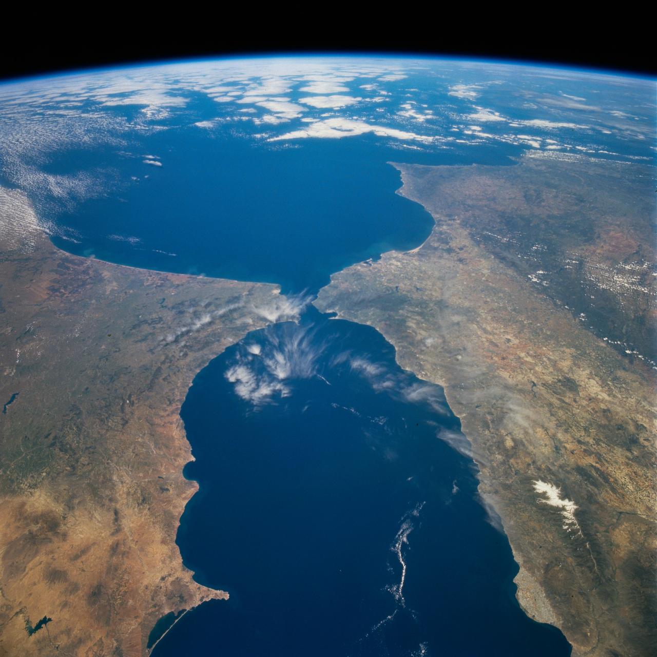
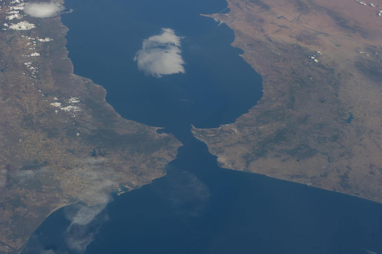
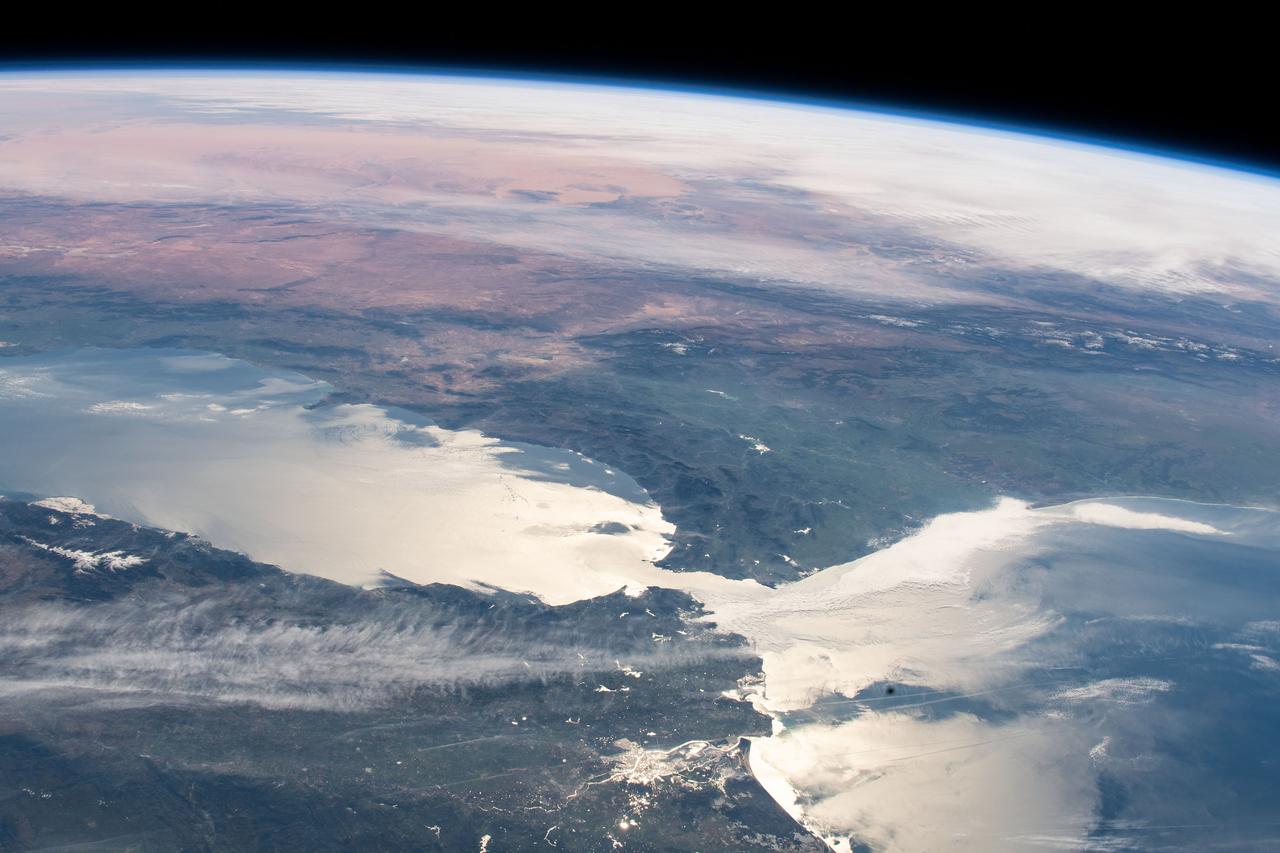
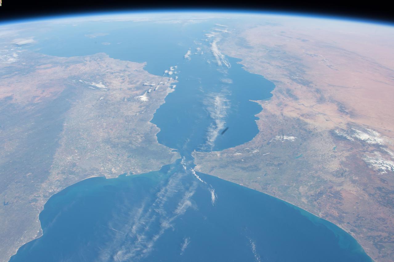
SL2-05-370 (22 June 1973) --- Gateway to the Atlantic, since ancient times the Strait of Gibraltar (36.5N, 4.5W) is also the border between Africa and Europe. In Spain to the north, the dark area near the coast is the delta of the Guadalquivir River and the city of Seville. The small spike of land on the north side of the strait is the actual Rock of Gibraltar. On the African side, a cloud front cutting across from the coast is blowing into Europe from Morocco and Algeria. Photo credit: NASA
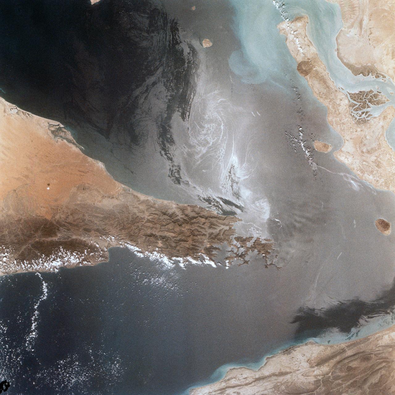
Portions of Oman, The United Arab Emirates and Iran are seen at the Strait of Hormuz (26.0N, 56.0E) in this view. A number of ship wakes can be seen in the area of the strait. Sunglint in the Persian Gulf to the northwest, accentuates the complex currents and oil slicks, seen as dark toned blue streaks on the surface. Qeshm Island, just off the coast of Iran, can be seen on the edge of the photo.

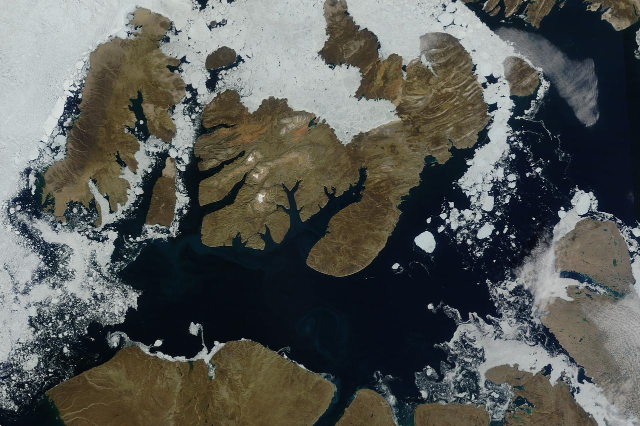
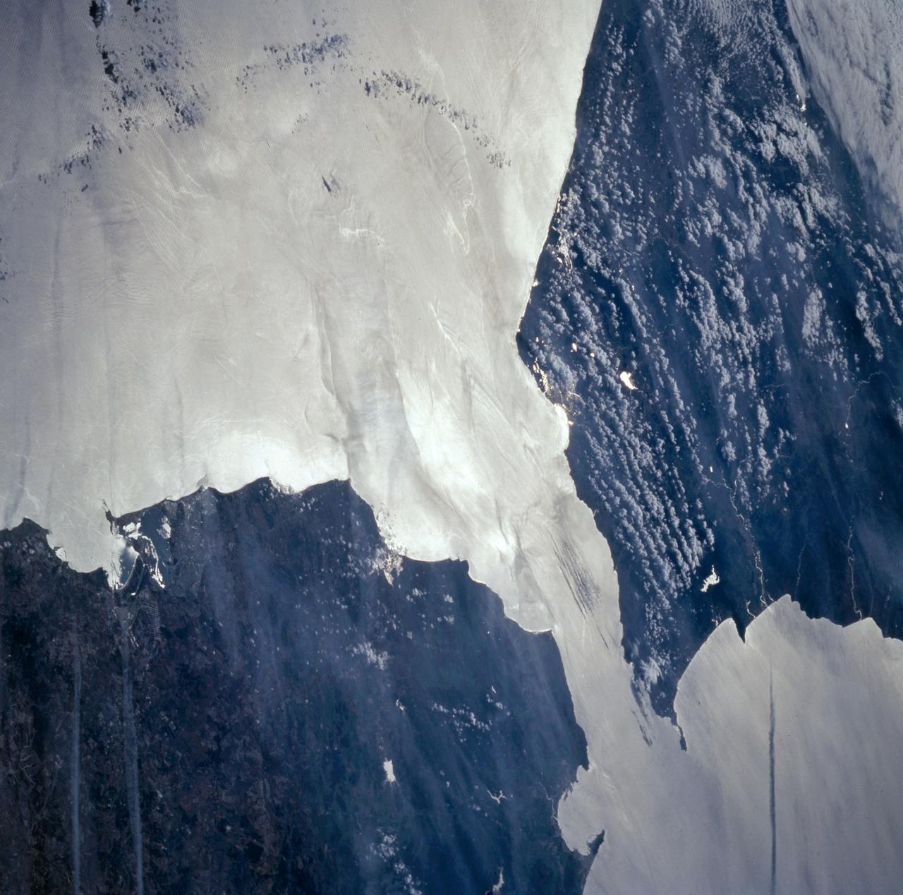
The late winter sun shone brightly on a stunning scene of clouds and ice in the Davis Strait in late February, 2013. The Moderate Resolution Imaging Spectroradiometer aboard NASA’s Aqua satellite captured this true-color image on February 22 at 1625 UTC. The Davis Strait connects the Labrador Sea (part of the Atlantic Ocean) in the south with Baffin Bay to the north, and separates Canada, to the west, from Greenland to the east. Strong, steady winds frequently blow southward from the colder Baffin Bay to the warmer waters of the Labrador Sea. Over ice, the air is dry and no clouds form. However, as the Arctic air moves over the warmer, open water the rising moist air and the temperature differential gives rise to lines of clouds. In this image, the clouds are aligned in a beautiful, parallel pattern. Known as “cloud streets”, this pattern is formed in a low-level wind, with the clouds aligning in the direction of the wind. Credit: NASA/GSFC/Jeff Schmaltz/MODIS Land Rapid Response Team <b><a href="http://www.nasa.gov/audience/formedia/features/MP_Photo_Guidelines.html" rel="nofollow">NASA image use policy.</a></b> <b><a href="http://www.nasa.gov/centers/goddard/home/index.html" rel="nofollow">NASA Goddard Space Flight Center</a></b> enables NASA’s mission through four scientific endeavors: Earth Science, Heliophysics, Solar System Exploration, and Astrophysics. Goddard plays a leading role in NASA’s accomplishments by contributing compelling scientific knowledge to advance the Agency’s mission. <b>Follow us on <a href="http://twitter.com/NASA_GoddardPix" rel="nofollow">Twitter</a></b> <b>Like us on <a href="http://www.facebook.com/pages/Greenbelt-MD/NASA-Goddard/395013845897?ref=tsd" rel="nofollow">Facebook</a></b> <b>Find us on <a href="http://instagram.com/nasagoddard?vm=grid" rel="nofollow">Instagram</a></b>
NASA image acquired August 17, 2010 In mid-August 2010, the Northwest Passage was almost—but not quite—free of ice. The ice content in the northern route through the passage (through the Western Parry Channel) was very light, but ice remained in McClure (or M’Clure) Strait. The Moderate Resolution Imaging Spectroradiometer (MODIS) on NASA’s Terra satellite captured this natural-color image on August 17, 2010. Although most of McClure Strait looks perfectly ice-free, immediately west of Prince Patrick Island, a band of sea ice stretches southward across the strait (left edge of the image). The National Snow and Ice Data Center Sea Ice News and Analysis blog reported that even more ice remained in the southern route (through Amundsen’s Passage) of the Northwest Passage in mid-August 2010. Nevertheless, the ice content in the northern route was not only well below the 1968–2000 average, but also nearly a month ahead of the clearing observed in 2007, when Arctic sea ice set a record low. As of mid-August 2010, however, overall sea ice extent was higher than it had been at the same time of year in 2007. Credit: NASA/GSFC/Jeff Schmaltz/MODIS Land Rapid Response Team Caption by Michon Scott. To learn more go to: <a href="http://earthobservatory.nasa.gov/NaturalHazards/view.php?id=45333" rel="nofollow">earthobservatory.nasa.gov/NaturalHazards/view.php?id=45333</a> Instrument: Terra - MODIS <b><a href="http://www.nasa.gov/centers/goddard/home/index.html" rel="nofollow">NASA Goddard Space Flight Center</a></b> is home to the nation's largest organization of combined scientists, engineers and technologists that build spacecraft, instruments and new technology to study the Earth, the sun, our solar system, and the universe. <b>Follow us on <a href="http://twitter.com/NASA_GoddardPix" rel="nofollow">Twitter</a></b> <b>Join us on <a href="http://www.facebook.com/pages/Greenbelt-MD/NASA-Goddard/395013845897?ref=tsd" rel="nofollow">Facebook</a><b> Click here to see more images from <b><a href="#//earthobservatory.nasa.gov/" rel="nofollow"> NASA Goddard’s Earth Observatory</a></b></b></b>
STS039-151-193 (28 April-6 May 1991) --- The Strait of Gibraltar, the only outlet for the Mediterranean Sea, was photographed with a large format handheld camera by the STS-39 crew members. Scientists site evidence in Shuttle photography that the Mediterranean Sea dried up a number of times between 5 million and 20 million years ago. Sea levels, they say, dropped slightly, cutting off the Mediterranean (top right) from the Atlantic Ocean (bottom). In southern Spain, the dark area near the coast is the delta of the Guadalquivir River with the city of Seville. The Sierra Nevada range still has some snow. A small field fire near the Spanish coast has generated a conspicuous smoke plume. The small spike of land on the north side of the Strait is the Rock of Gibraltar, an outpost of the British empire. The larger spike of land on the north coast of Africa marks the border between Morocco (center foreground) and Algeria (right). The sharp line cutting across them Mediterranean (top right) marks the edge of a dust cloud blowing from Africa into Europe. Photo credit: NASA
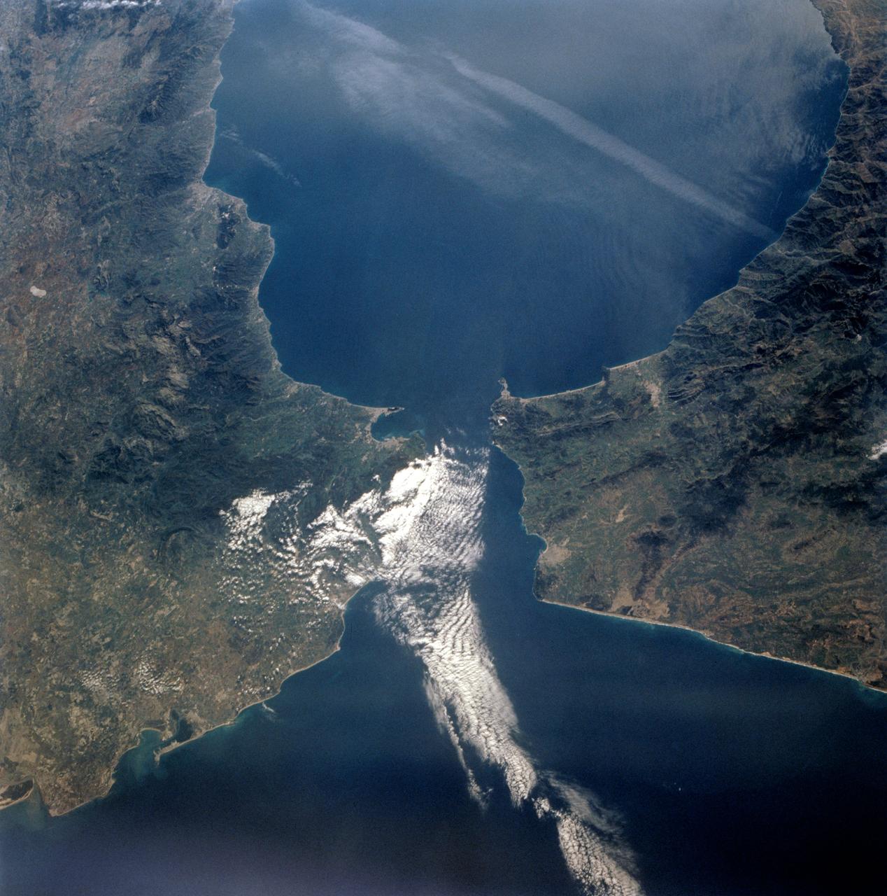
41G-120-082 (5-13 Oct. 1984) --- This High oblique view was photographed with a medium format camera aboard the Earth-orbiting space shuttle Challenger. It features the Strait of Gibraltar and the Mediterranean Sea. Unlike vertical photographs from this area taken by crews of previous spaceflights, this oblique view allows extensive viewing into Spain and Morocco. Photo credit: NASA
STS-56 Earth observation taken aboard Discovery, Orbiter Vehicle (OV) 103, is of the Strait of Gibraltar. A small bank of clouds marks the passage between Spain and Morocco at the western edge of the Mediterranean Sea. This passage, one of the two Pilars of Hercules of the Ancient Greeks, is now known as the Strait of Gibraltar. The cities of Cadiz on the Atlantic Coast of Spain and Malaga on the Mediterranean coast, as well as Tangier, Morocco (facing the strait), can be seen. According to NASA scientists studying the STS-56 photos, a subtle difference in the water color on the Atlantic side suggests that a pulse of surface water had recently flowed out of the Mediterranean into the Atlantic.
This image from NASA Terra satellite, acquired on August 18, 2000 during Terra orbit 3562, show the Bering Strait, with Seward Peninsula of Alaska to the east, and Chukotskiy Poluostrov of Siberia to the west.
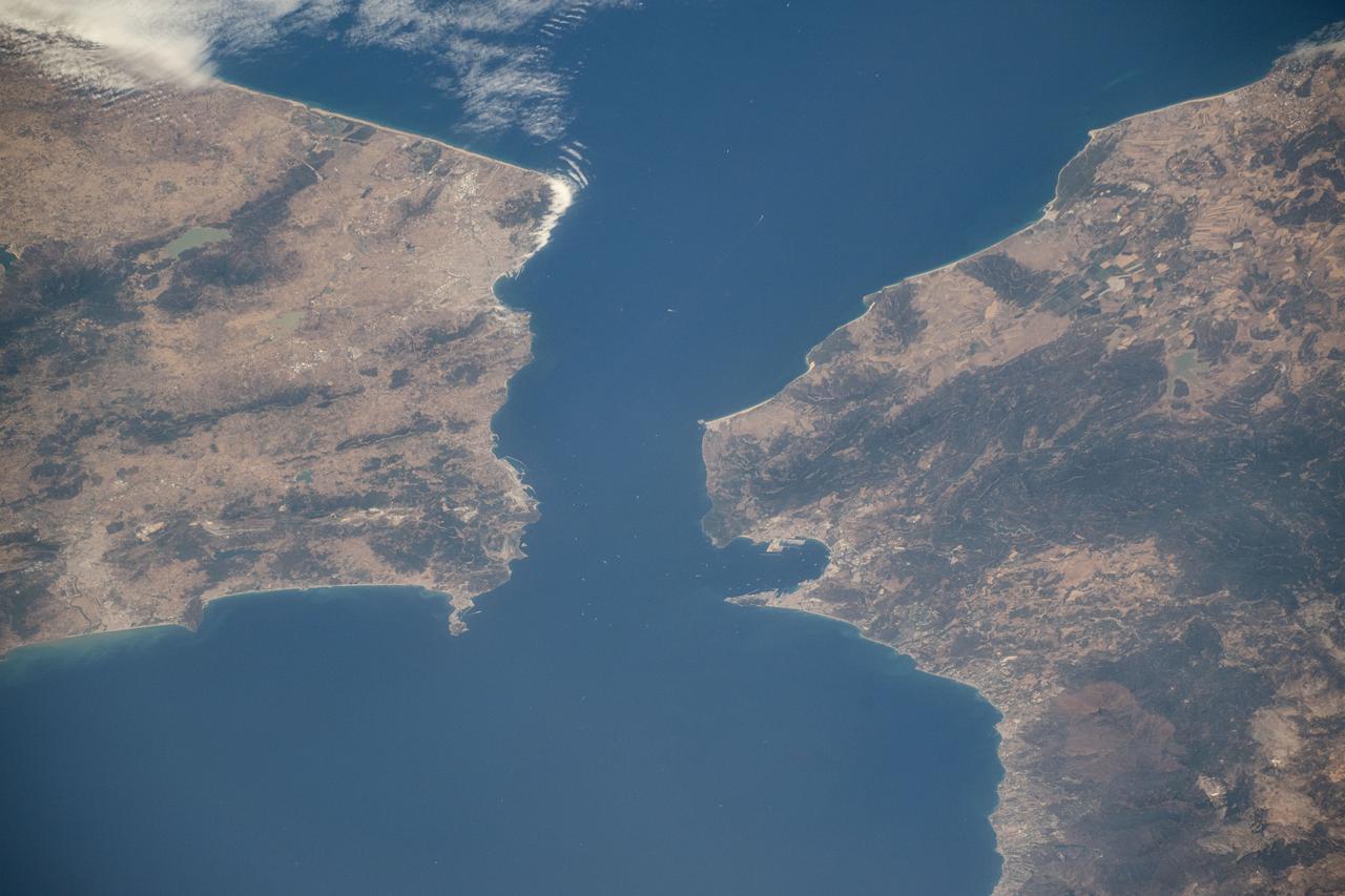
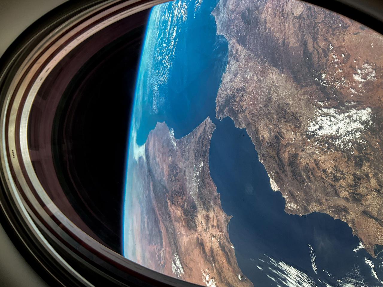
iss071e414110 (July 30, 2024) -- The Strait of Gibraltar separates Morocco (left) and Spain (right) while connecting the Atlantic Ocean to the Mediterranean Sea. The narrow strait spans only ~8 miles (~13 kilometers) between the two countries. As the International Space Station soared 258 miles above, NASA astronaut Matthew Dominick captured this photo.
STS058-73-009 (18 Oct-1 Nov 1993) --- Atlantic water flowing with the tide through the Strait of Gibraltar into the Mediterranean generates internal waves as depicted in this photo. The incoming cool, less dense Atlantic water flows over the warm, more saline Mediterranean water. As the tide moves into the Strait of Gibraltar it encounters the Camarinal Sill, which is like a cliff under water, south of Camarinal Point, Spain. Internal waves are generated at the Sill and travel along the density boundary between the Atlantic water and the Mediterranean water. Internal waves have very little effect on the sea surface, except for gentle slopes and slight differences in roughness. We can see them in the Space Shuttle photos because of sunglint which reflects off the water. Internal waves smooth out some of the capillary waves at the surface in bands. The sun reflects more brightly from these smooth areas showing us the pattern of the underwater waves. The Bay of Cadiz on the southwest coast of Spain, the Rock of Gibraltar, and the Moroccan coast are also visible in this photo.
This 34 by 59 km sub-scene, acquired on July 5, 2000, covers the eastern part of the Strait of Gibraltar, separating Spain from Morocco. The promontory on the eastern side of the conspicuous Spanish port is the Rock of Gibraltar. The Rock of Gibraltar was once one of the two classical Pillars of Hercules, crowned with silver columns by Phoenician mariners to mark the limits of safe navigation for the ancient Mediterranean peoples. The rocky promontory still commands the western entrance to the Mediterranean Sea, separated from North Africa only by the narrow Strait of Gibraltar. A British colony, Gibraltar occupies a narrow strip of land at the southernmost tip of the Iberian Peninsula. It is separated from the Spanish mainland by a neutral zone contained on a narrow, sandy isthmus. The rocky limestone and shale ridge known as the Rock rises abruptly from the sea, to a maximum elevation of 426 meters (1,398 feet). Because of its strategic location and formidable topography, Gibraltar serves mainly as a British fortress. The Rock has traditionally been a symbol of British naval strength. Most of its sparse land is taken up by air and naval installations, and the civilian population is small. The image is centered at 36 degrees north latitude, 5.5 degrees west longitude. http://photojournal.jpl.nasa.gov/catalog/PIA11167
This perspective view shows the Strait of Gibraltar, which is the entrance to the Mediterranean Sea from the Atlantic Ocean. Europe (Spain) is on the left. Africa (Morocco) is on the right. The Rock of Gibraltar, administered by Great Britain, is the peninsula in the back left. The Strait of Gibraltar is the only natural gap in the topographic barriers that separate the Mediterranean Sea from the world's oceans. The Sea is about 3700 kilometers (2300 miles) long and covers about 2.5 million square kilometers (one million square miles), while the Strait is only about 13 kilometers (8 miles) wide. Sediment samples from the bottom of the Mediterranean Sea that include evaporite minerals, soils, and fossil plants show that about five million years ago the Strait was topographically blocked and the Sea had evaporated into a deep basin far lower in elevation than the oceans. Consequent changes in the world's hydrologic cycle, including effects upon ocean salinity, likely led to more ice formation in polar regions and more reflection of sunlight back to space, resulting in a cooler global climate at that time. Today, topography plays a key role in our regional climate patterns. But through Earth history, topographic change, even perhaps over areas as small as 13 kilometers across, has also affected the global climate. This image was generated from a Landsat satellite image draped over an elevation model produced by the Shuttle Radar Topography Mission (SRTM). The view is eastward with a 3-times vertical exaggeration to enhance topographic expression. Natural colors of the scene (green vegetation, blue water, brown soil, white beaches) are enhanced by image processing, inclusion of some infrared reflectance (as green) to highlight the vegetation pattern, and inclusion of shading of the elevation model to further highlight the topographic features. Landsat has been providing visible and infrared views of the Earth since 1972. SRTM elevation data matches the 30-meter (99-feet) resolution of most Landsat images and will substantially help in analyses of the large Landsat image archive. Elevation data used in this image was acquired by the Shuttle Radar Topography Mission (SRTM) aboard the Space Shuttle Endeavour, launched on February 11, 2000. http://photojournal.jpl.nasa.gov/catalog/PIA03397
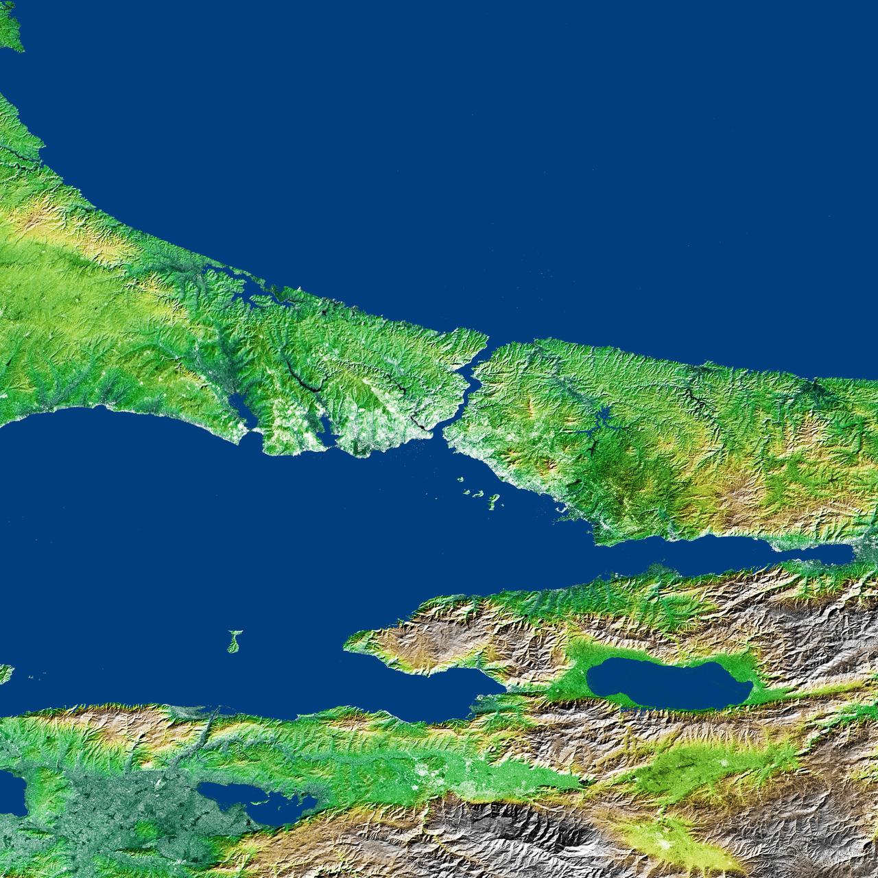
The Bosporus also spelled Bosphorus is a strait that connects the Black Sea with the Sea of Marmara in the center of this view of northwest Turkey, taken during NASA Shuttle Radar Topography Mission.
iss073e0983013 (Oct. 21, 2025) --- The Taiwan Strait separates the eastern coast of China’s Fujian Province (right) from the island nation of Taiwan (lower left) in this photograph taken from the International Space Station as it orbited 257 miles above Earth. The strait is a vital waterway in East Asia, supporting the fishing, shipping, and communications industries.
iss072e574770 (Jan. 29, 2025) --- The Bosphorus Strait splits the city of Istanbul, Türkiye, and connects the Black Sea with the Sea of Marmara in this photograph from the International Space Station as it orbited 260 miles above where Europe connects to Asia.

STS060-88-070 (3-11 Feb 1994) --- This view shows sunglint in the Strait of Gibralter. In this photograph a high pressure atmospheric system over the Iberian Peninsula has set the conditions for seeing a plankton bloom along the Moroccan coast in the Alboran Sea (Western Mediterranean) coastal counter current as well as illumining the influence of winds in the sunglint pattern near the Strait of Gibraltar. Where the water is ruffled from a wind gust, such as off Cadiz, Spain, the surface is less reflective and thus appears dark. A combination of the effects of the tide and the surface winds through the Strait of Gibraltar have created a unique sunglint pattern at the entrance of the Mediterranean. The Atlantic Ocean waters are flowing with the tide through the Strait of Gibraltar into the Mediterranean Sea and are probably smoothing out some of the smaller waves at the surface. The incoming tide generates internal waves as can be faintly seen in this photograph. The incoming relatively cooler, less dense Atlantic water flows over the warm, more saline Mediterranean water. As the tide moves into the Strait of Gibraltar it encounters the Camarinal Sill, which is like a cliff under the water, south of Camarinal Point, Spain. Internal waves are generated at this sill and they travel along the density boundary between the Atlantic water and the Mediterranean water masses. There is little evidence of the internal waves at the surface of the ocean. We can see them in spacecraft photography because of the sunglint which reflects off the different water layers in differential patterns. The internal waves also smooth out some of the bands of capillary waves at the surface. That is, the sun reflects more brightly from these smooth areas, showing the pattern of the underwater waves more prominently than do the surface waves. The Bay of Cadiz on the southwest coast of Spain, the Rock of Gibraltar, and the Moroccan coast are also beautifully illustrated in this photography. The focus for scientists, however, remains the high clarity and spatial resolution given by sunglint studies to physical phenomena in the ocean.
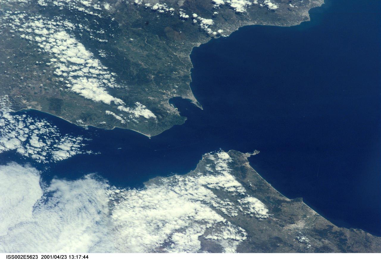
ISS002-E-5623 (23 April 2001) --- The Strait of Gibraltar, with part of Spain and all of Gibraltar at upper left and upper center, respectively, and portions of Morocco at bottom, was photographed with a digital still camera by the Expedition Two crew onboard the International Space Station (ISS).
iss072e436132 (Dec. 28, 2024) --- The Korea Strait separates Busan, Korea (bottom left), and Fukuoka, Japan, in this photograph taken approximately 12:55 a.m. local time from the International Space Station as it orbited 258 miles above the Korean coast. Toward the top right, are the city lights of Osaka, Nagoya, and Tokyo.
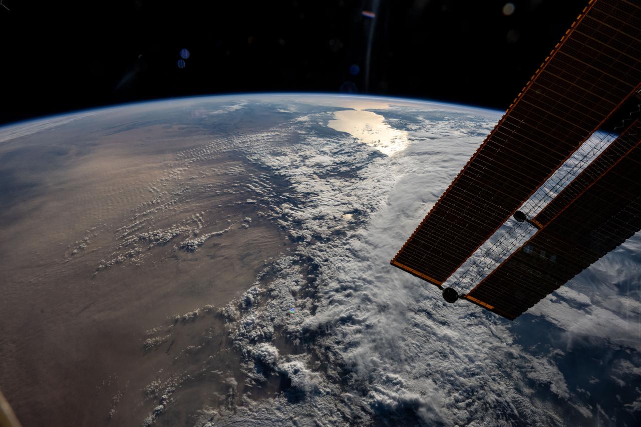
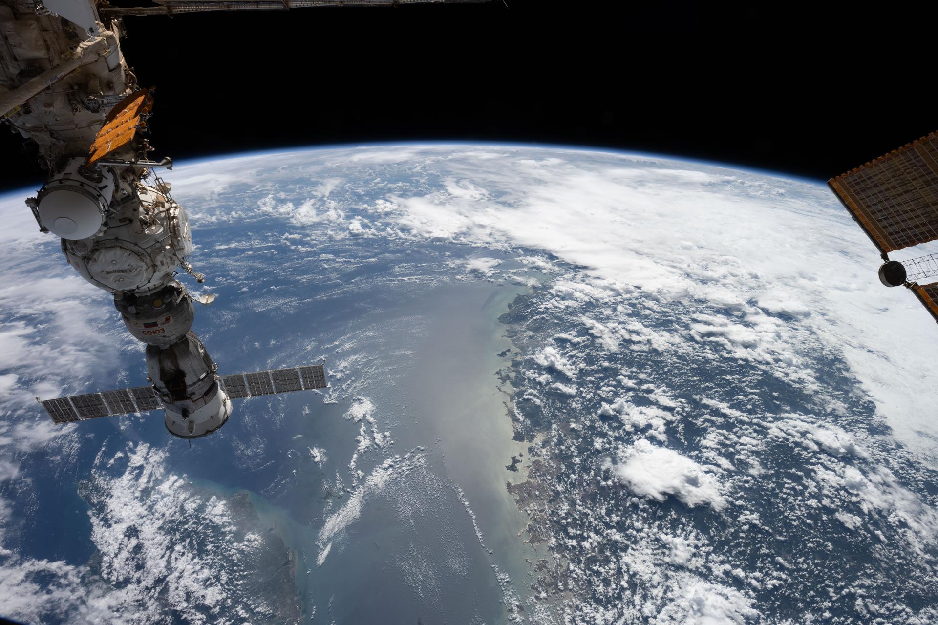
iss073e0032281 (May 15, 2025) --- The sun's glint beams off the Strait of Gibraltar at the top of this photograph as the International Space Station orbited 261 miles above a cloudy Mediterranean Sea. At left, is the Sahara Desert extending across the north African continent. In the right foreground, is a set of of the orbital outpost's main solar arrays.
iss074e0425752 (March 29, 2026) --- The Strait of Gibraltar separates the European nation of Spain (left) from the African nation of Morocco (right) and connects the Atlantic Ocean to the Mediterranean Sea. The International Space Station was orbiting 266 miles above Spain at the time of this photograph. Credit: NASA
S66-45749 (18 July 1966) --- Straits of Gibraltar, Mediterranean Sea, Spain in background, Algeria and Morocco in foreground as seen from Gemini-10 spacecraft. Photo credit: NASA
S65-45737 (22 Aug. 1965) --- Looking northeast, the Strait of Gibraltar, Morocco (foreground) and Spain (background) are photographed from the Gemini-5 spacecraft during its 14th revolution of Earth.
Swift currents flow through the Strait of Gibraltar, producing complicated patterns in the surface waters. Some of those patterns are highlighted in the sunglint in this photograph. The Mediterranian Sea is on the upper right, the Atlantic Ocean in in the lower left. Few features can be seen on the Mediterranian side, but current shears (straight lines coming off Spain), several sets of internal waves (impinging on the Spanish continental shelf) and ship wakes can be seen on the Atlantic side, west of Cadiz. Both Tangier and Cadiz show up in the sunglint as well.
iss072e435710 (Dec. 28, 2024) --- The Taiwan Strait separates China's southeast coast from Taiwan in this photograph from the International Space Station as it orbited 257 miles above Asia. From bottom center toward the upper left, the city lights from Quanzhuo to Shanghai light up the Chinese coast. Toward right center, the city lights from Taipei to Tainan (bottom right) illuminate Taiwan's western coast. This frame was captured approximately 12:51 a.m. local time.

Dr. Kevin Strait, curator of history, National Museum of African American History and Culture (NMAAHC), speaks at an event to commemorate Black Space Week (BSW) 2024 titled, "Beyond the Color Lines From Science Fiction to Science Fact," in the Oprah Winfrey Theater at the Smithsonian National Museum of African American History and Culture, Monday, June 17, 2024 in Washington. Photo Credit: (NASA/Aubrey Gemignani)
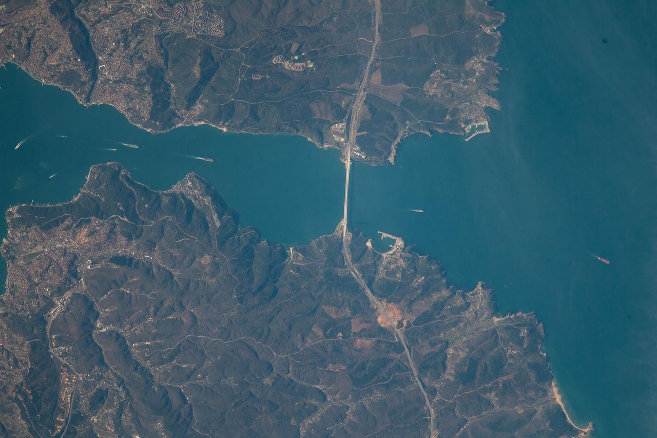
ISS036-E-036611 (23 Aug. 2013) --- One of the Expedition 36 crew members aboard the International Space Station on Aug. 23 exposed this image of the Strait of Gibraltar, where Europe and Africa meet and where the Atlantic Ocean waters flow through the strait into the Mediterranean Sea. A popular photographic target of astronauts has always been the Strait of Gibraltar, easily spotted at left center in this wide photograph, shot from the International Space Station. Spain is to the north (top) and Morocco to the south. The strait is 36 miles (58 kilometers) long and slims down to 8 miles (13 kilometers) at it?s most narrow point. The British colony of Gibraltar is north of the strait.
iss073e0688699 (Aug. 26, 2025) --- The blue-green lights of fishing boats, designed to lure squid, sardines, or mackerel, dot the East China Sea and the Taiwan Strait contrasting with the coastal city lights of Taiwan and China. The International Space Station was orbiting 259 miles above the South China Sea just south of Taiwan at approximately 11:53 p.m. local time when this photograph was taken.
STS077-718-088 (19-29 May 1996) --- A popular photographic target of Space Shuttle astronauts has always been the Strait of Gibraltar seen at center in this wide photograph, shot from the Space Shuttle Endeavour. Spain is to the north (right) and Morocco to the south. The strait is 36 miles (58 kilometers) long and narrows to 8 miles (13 kilometers) at it’s most narrow point. The winds in the strait are either easterly or westerly. The British colony of Gibraltar is the semi-circular feature north of the strait. Gibraltar is considered to be one of the Pillars of Hercules. The white colored area to the southeast of Gibraltar on the Moroccan coast is the city of Tanger (Tangier). The snow covered mountains in Spain are the Sistemas Penibeticos.
The Diomede Islands consisting of the western island Big Diomede, and the eastern island Little Diomede are two rocky islands located in the middle of the Bering Strait between Russia and Alaska. This image was acquired by NASA Terra satellite.
The false-color VNIR image from NASA Terra spacecraft was acquired off the island of Tsushima in the Korea Strait shows the signatures of several internal wave packets, indicating a northern propagation direction.
The Channel Tunnel is a 50.5 km-long rail tunnel beneath the English Channel at the Straits of Dover. It connects Dover, Kent in England with Calais, northern France. This image was acquired by NASA Terra spacecraft.
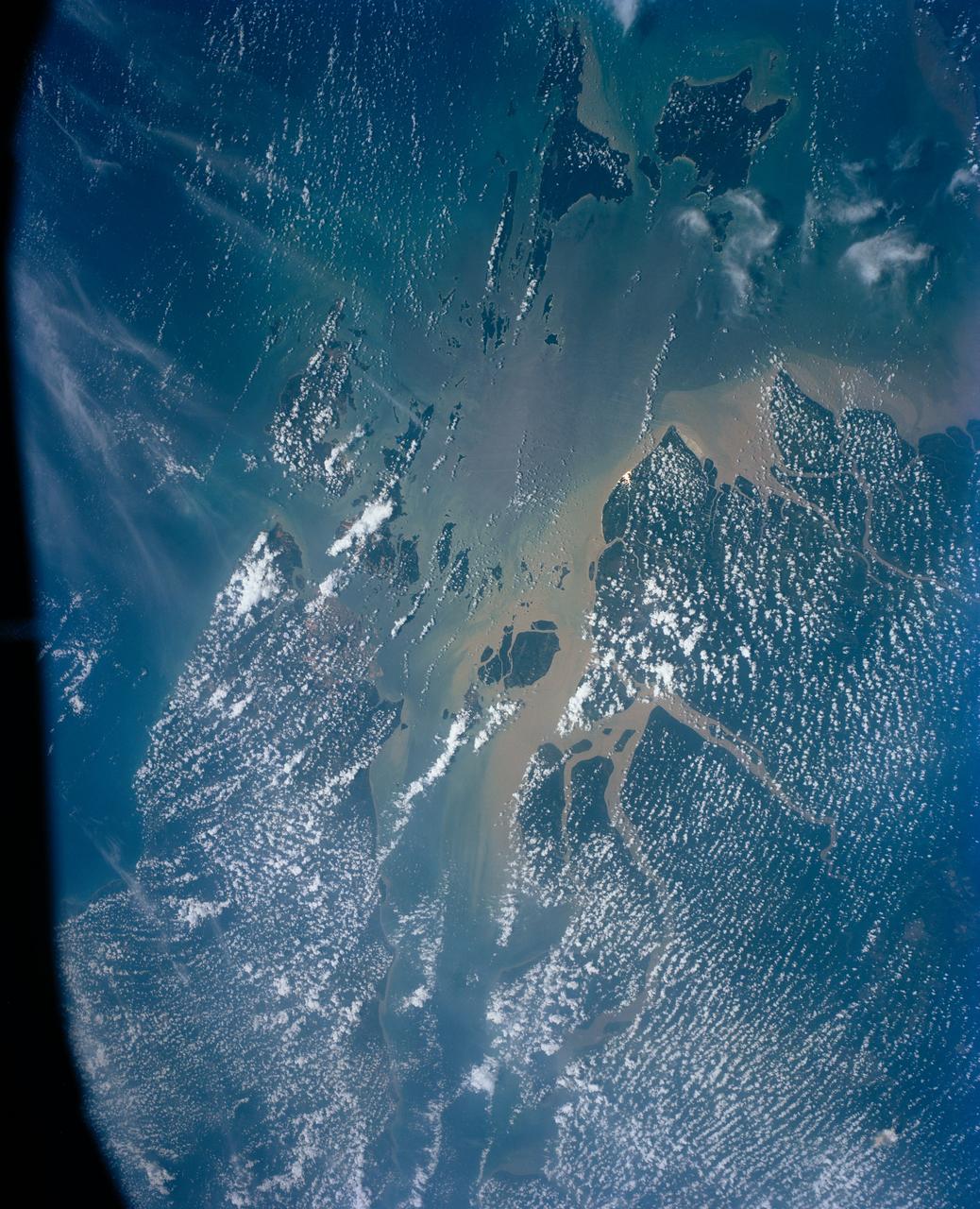
This view shows the area around Northeastern Sumatra, Indonesia (1.0N, 104.0E). The city of Singapore and the Singapore Strait is in the center at the southern tip of the Malay Peninsula. The Singapore Strait is the eastern extension of the Strait of Malacca and separates the Malay Peninsula from Sumatra. Large sediment plumes from the rivers attest to the local soil erosion and industrial dumping ofd wastes.
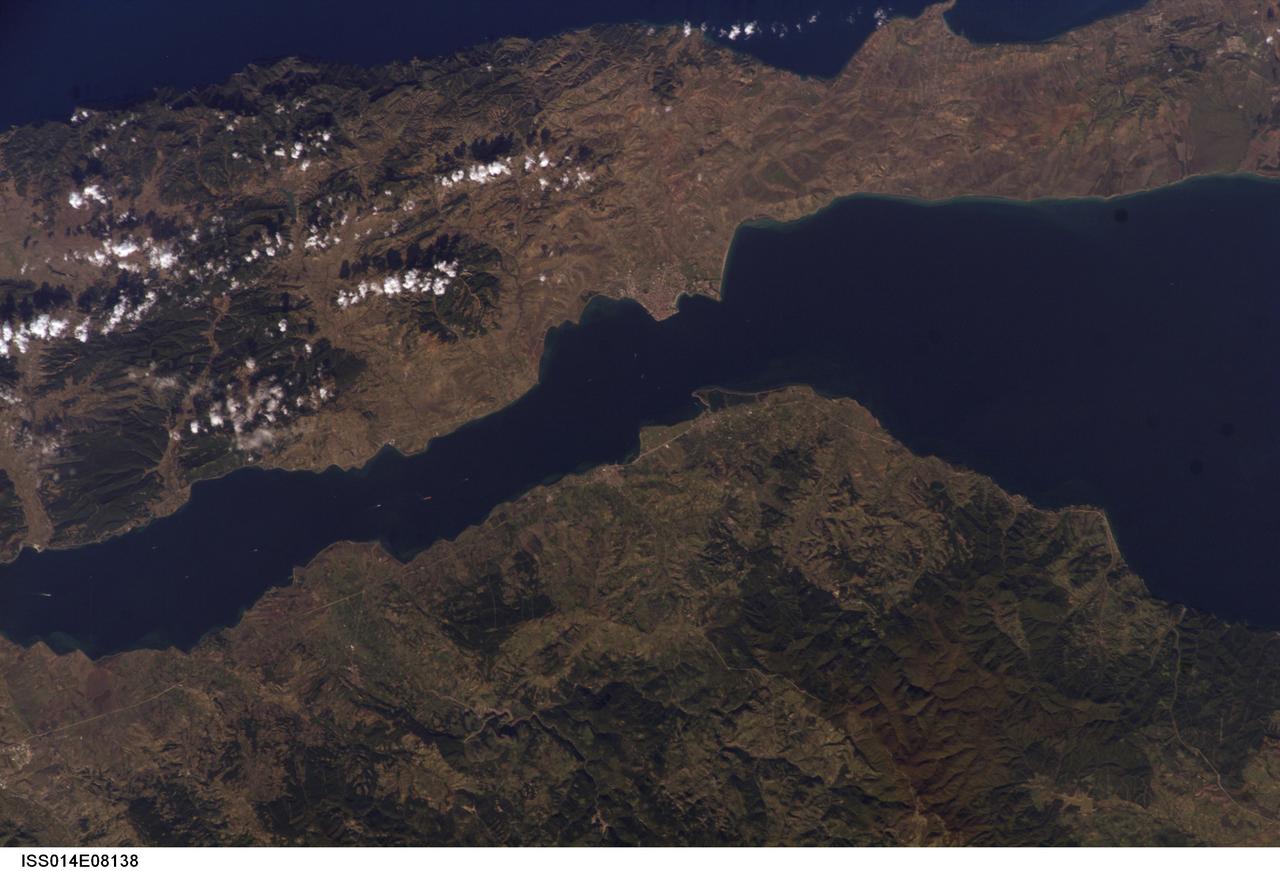
ISS014-E-08138 (9 Nov. 2006) --- Gallipoli and Dardanelles Strait, Turkey are featured in this image photographed by an Expedition 14 crewmember on the International Space Station. The city of Gallipoli (or Gelibolu in Turkish) sits at a crossroads between the Marmara and Aegean Seas, connected by the Dardanelles Strait. According to scientists, the strait is a 61 kilometer-long drowned fault valley formed during tectonic activity during the Tertiary period as the Arabian, Indian, and African plates collided with the Eurasian plate. This faulting, which formed the great mountain ranges of the Alps and Himalayas, also created the rugged terrain of western Turkey visible in the lower half of this image. Plate collision continues today, leading to frequent strike-slip (side-by-side relative motion along a fault, rather than up or down motion) earthquakes in the region as Turkey moves westward in relation to Eurasia (sometimes called escape tectonics). The urbanized area of modern Gallipoli is visible as a light gray to pink region at the entrance to the Dardanelles Strait. Water in the Strait flows in both northeast and southwest directions due to opposite surface and undercurrents. Several ships are visible in the Strait to the southwest of Gallipoli (center left).
iss059e036722 (April 28, 2019) --- The International Space station was flying 258 miles above of China's eastern border with Russia when an Expedition 59 crewmember photographed the frozen Strait of Tartary. The strait separates the Russian island of Sakhalin from the Asian continent. The sun's glint beams off the Northern Pacific coast of Sakhalin.

KENNEDY SPACE CENTER, FLA. -- United Space Alliance (USA) Shuttle Systems Inspector David Strait talks to the media in the NASA-KSC Newsroom. Strait is the USA quality inspector who first discovered a crack in one of the Space Shuttle orbiter's Main Propulsion System (MPS) flow liners.
iss071e365604 (July 19, 2024) --- The Soyuz MS-25 crew ship is picture docked to the Prichal docking module as the International Space Station orbited 271 miles above the Bass Strait in between Australia's mainland province of Victoria and its island province of Tasmania.
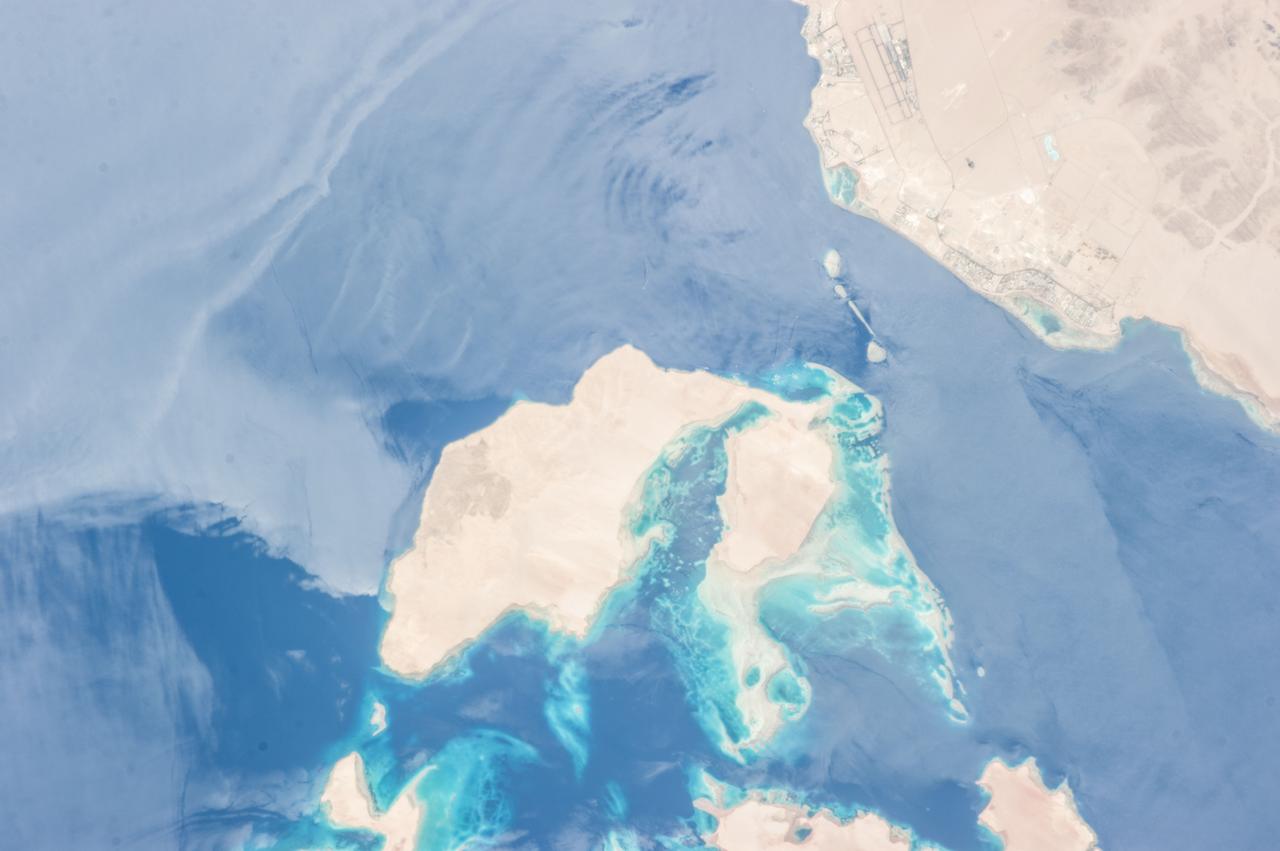
ISS036-E-010628 (24 June 2013) --- Strait of Tiran, Red Sea and Gulf of Aqaba are featured in this image photographed by an Expedition 36 crew member on the International Space Station. The approximately six-kilometer wide Strait of Tiran (also known as the Straits of Tiran) between the Egyptian mainland and Tiran Island separates the Gulf of Aqaba from the Red Sea, and provides two channels (290 meters and 73 meters deep, respectively) navigable by large ships bound for ports in Jordan and Israel. A smaller passage also exists between the east side of Tiran Island and Saudi Arabia, but this a single channel that is 16 meters deep. Due to its strategic position, control of the Strait has been an important factor in historical conflicts of the region, such as the Suez Crisis in 1956 and the Six-Day War in 1967. This photograph illustrates the morphology of the Strait. The relatively clear, deep-water passages of the western Strait of Tiran are visible at right, while the more sinuous shallow-water passage on the Saudi Arabia side can be seen at bottom center. Light blue to turquoise areas around Tiran Island indicate shallow water, while the island itself is arid and largely free of vegetation. Coral reefs are also found in the Straits of Tiran and are a popular diving destination. The silvery sheen on the water surface within the Strait and the south of Tiran Island is sunglint – light reflecting off the water surface back towards the observer on the space station. Disturbance to the water surface, as well as presence of substances such as oils and surfactants, can change the reflective properties of the water surface and highlight both surface waves and subsurface currents. For example, a large wave set is highlighted by sunglint at upper left.
ISS036-E-028444 (3 Aug. 2013) --- Hervey Bay, Queensland, Australia is featured in this image photographed by an Expedition 36 crew member on the International Space Station. The northern end of the Great Sandy Strait and Hervey Bay are highlighted in this photograph. The Strait is an estuary that separates the mainland coastline of the state of Queensland, Australia from neighboring Fraser Island. The mainland side of the Strait includes the city of Hervey Bay, visible at top center. Other communities that have become part of the larger metropolitan area include Scarness, Booral, and Urangan. A small vegetated island and shallow sand bars of the Great Sandy Strait are visible at center left, while submerged sands appear as bright blue flowing ribbons at center. A small, bright white exposure of sand is visible above the water level near the center point of the image. While once a major freighting center for the sugar cane industry, the local economy is now largely based on tourism, with whale watching tours a popular attraction. The Great Sandy Strait estuary provides habitat for breeding fish, crustaceans, turtles, and other sea life, as well as a wide variety of birds. Nearby Fraser Island is the world?s largest sand island and a World Heritage site.
Earth observation taken during a night pass by the Expedition 37 crew. Per Twitter message: The Korea Strait.
STS047-151-488 (12 - 20 Sept 1992) --- In this large format camera image, the forested Cascade Range appears along the left side; the Pacific Ocean, on the right. The frame was photographed as the Space Shuttle Endeavour flew north to south over Vancouver and Seattle. Many peaks in the Cascades reach altitudes greater than 9,000 feet and remain snowcapped even in mid-summer. The Strait of Juan de Fuca separates the Olympic Peninsula (top right) from Vancouver Island (bottom right). Snowcapped Mt. Olympus (7,965 feet) is one of the wettest places in the continental United States, with rainfall in excess of 120 inches per year. The port cities of Seattle and Tacoma occupy the heavily indented coastline of Puget Sound (top center). They appear as light-colored areas on the left side of the Sound. The angular street pattern of Tacoma is visible at the top of the picture. The international boundary between Canada and the United States of America runs across the middle of the view. The city of Victoria (center) is the light patch on the tip of Vancouver Island. Canada's Fraser River Delta provides flat topography on which the cities of Vancouver, Burnaby, and New Westminster were built. These cities appear as the light-colored area just left of center. The Fraser River can be seen snaking its way out of the mountains at the apex of the delta. Numerous ski resorts dot the slopes of the mountains (bottom left) that rise immediately to the north of Vancouver. In the same area the blue water of Harrison and other, smaller lakes fills some of the valleys that were excavated by glaciers in the "recent" geological past, according to NASA scientists studying the photography. A Linhof camera was used to expose the frame.
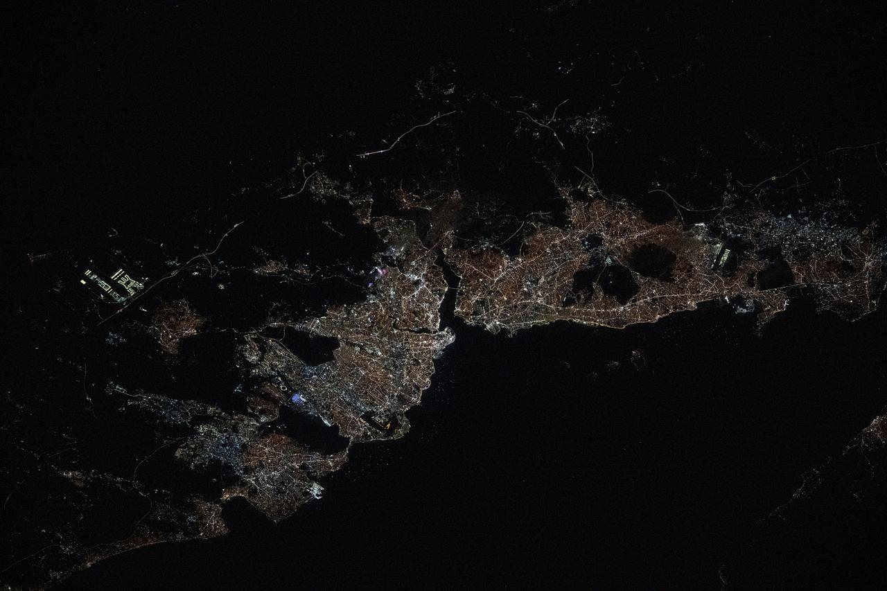
iss072e519796 (Jan. 23, 2025) --- The city lights of Istanbul, Turkiye, with a population of about 15.7 million split by the Bosphorus strait in between the Sea of Mammara and the Black Sea, are pictured at approximately 9:44 p.m. local time from the International Space Staation as it orbited 259 miles above.
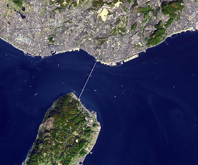
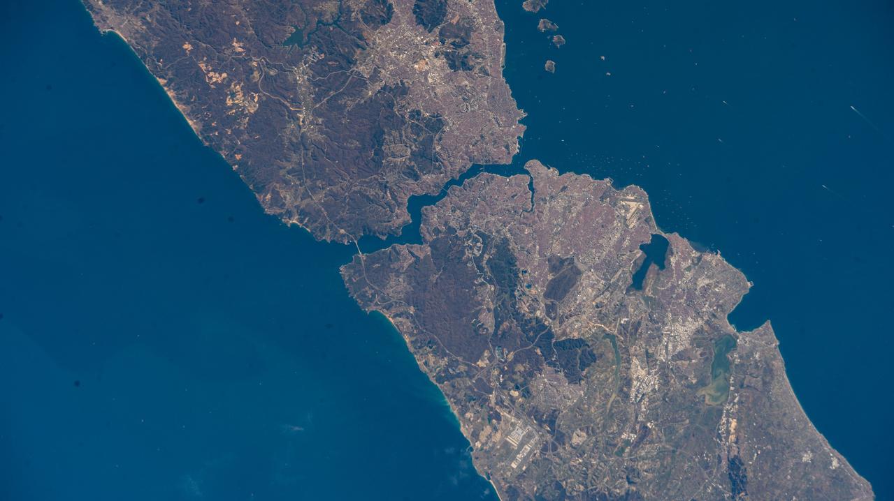
NASA Terra spacecraft shows the Akashi Kaikyo Bridge or Pearl Bridge, the longest central span of any suspension bridge in the world, at 1991 meters, connecting the city of Kobe, Japan with Iwaja on Awaji Island by crossing the busy Akashi Strait.

Earth observation taken by the Expedition 40 crew aboard the International Space Station (ISS). Folder lists this as: Near the straits of Magellan camera 2.
Earth Observation taken during a day pass by the Expedition 40 crew aboard the International Space Station (ISS). Folder lists this as: Near the Straits of Magellan - Glaciers.
Earth observation taken during a day pass by the Expedition 40 crew aboard the International Space Station. File identifies it as: Straits of Hormuz through Pakistan into India.

iss056e127068 (Aug. 6, 2018) --- The International Space Station was orbiting off the coast of Portugal when an Expedition 56 crew member photographed wildfires near its southern coast and the Strait of Gibraltar which separates Spain on the European continent from Morocco on the African continent. The North Atlantic Ocean connects to the Strait of Gibraltar which leads into the Mediterranean Sea.

ISS002-E-5627 (23 April 2001) --- Algecira (left), the Bay of Gibraltar (Bahia de Algecira) and "The Rock of Gibraltar" (right) are featured in this detailed vertical view on the European side of the Strait of Gibraltar. Ship traffic in the Bay and Gibraltar Dock Yard can easily be seen. This digital still camera's image is part of a series of pictures centering on the Strait of Gibraltar area which was recorded by the ISS Expedition Two crew on April 23, 2001.
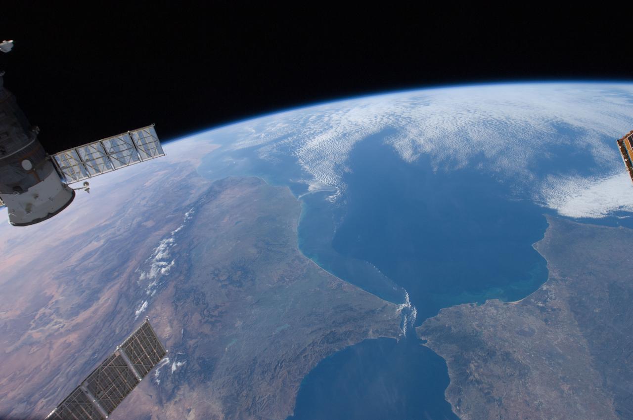
ISS030-E-030428 (31 Dec. 2011) --- This high oblique panorama shows Morocco and Spain as photographed by the Expedition 30 crew members aboard the International Space Station. The Atlantic Ocean, Straits of Gibraltar and Alboran Sea (the westernmost portion of the Mediterranean Sea) separate Spain on the right from Morocco on the left. Algeciras Harbor is the prominent notch cut out of the eastern end of the north shore of the Strait. A Russian spacecraft, docked to the orbital outpost, is in the upper left corner.

KENNEDY SPACE CENTER, FLA. -- U.S. Sen. Bill Nelson congratulates Rick Beckwith, with the Flow Liner Inspection & Repair team. Nelson presented gold seal Senate certificates to the team for their work on finding the cracks in orbiter flow liners and repairing them. Other team members behind Nelson are Mike Young (center) and Jerry Gouding (right). Not pictured are Tony Nesotas and David Strait. Strait first spotted the fuel-line crack; Goudy performed arc welding on one of Atlantis' flow liners.
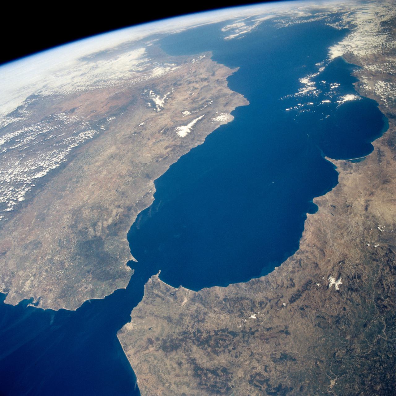
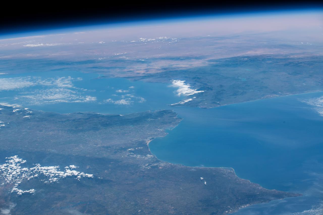
STS059-238-074 (9-20 April 1994) --- The Atlantic Ocean, Straits of Gibraltar, and Alboran Sea (the westernmost portion of the Mediterranean Sea) separate Spain on the left from Morocco on the right. Algeciras Harbor is the prominent notch cut out of the eastern end of the north shore of the Strait; the Rock of Gibraltar is the tiny arrowhead that separates the notch from the Alboran Sea. The Sierra Nevada, farther away down the Spanish coast, lives up to its name in this April scene. The difference in elevation between the Sierra Morena and the Guadalquivir River valley is highlighted nicely by cumulus clouds. Tangier, Morocco can be seen as a light-toned spot on the southern shore of the Strait, near the entrance to the Atlantic Ocean. Hasselblad photograph.
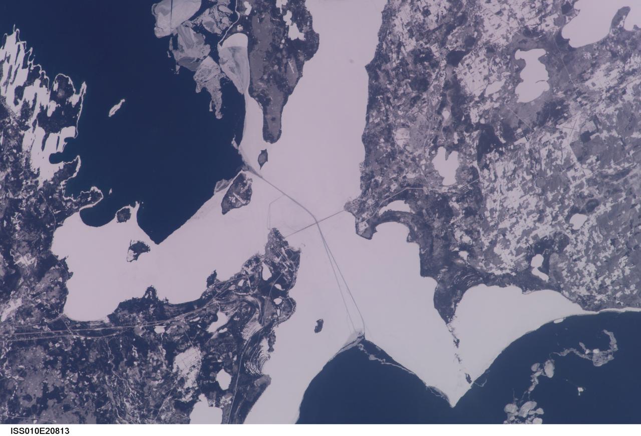
ISS010-E-23748 (9 April 2005) --- The Straits of Mackinac are featured in this image photographed by an Expedition 10 crewmember on the International Space Station (ISS). The Mackinac Bridge spans a stretch of water five miles wide between Michigan’s lower and upper peninsulas. The strait connects Lakes Michigan (left) and Huron (right). The bridge is a combination of pier-supported spans with a high, central suspension sector that allows passage of lake steamers. The suspension sector is the longest in the Americas (8614 feet or 1.6 miles). Prior to construction of the bridge, the only passage across the straits was by ferryboat. This view shows the ice broken into a series of irregular rafts that appear gray against bright water in this partial sunglint view. The shipping channel is maintained even through remnants of the ice mass, but the ice ridges can be hazardous to shipping during ice break-up.
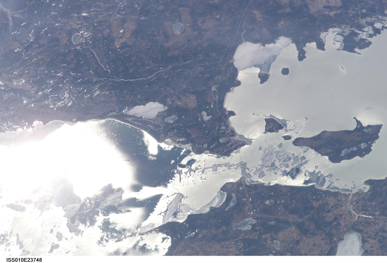
ISS010-E-20813 (22 March 2005) --- The Straits of Mackinac are featured in this image photographed by an Expedition 10 crewmember on the International Space Station (ISS). The Mackinac Bridge spans a stretch of water five miles wide between Michigan’s lower and upper peninsulas. The strait connects Lakes Michigan (left) and Huron (right). The bridge is a combination of pier-supported spans with a high, central suspension sector that allows passage of lake steamers. The suspension sector is the longest in the Americas (8614 feet or 1.6 miles). Prior to construction of the bridge, the only passage across the straits was by ferryboat. This view shows shipping lanes opened by ice breakers. A narrow passage leads to the small town of St. Ignace at the north end of the bridge (Mackinaw City appears at the south end). The shipping channel is maintained even through remnants of the ice mass, but the ice ridges can be hazardous to shipping during ice break-up.
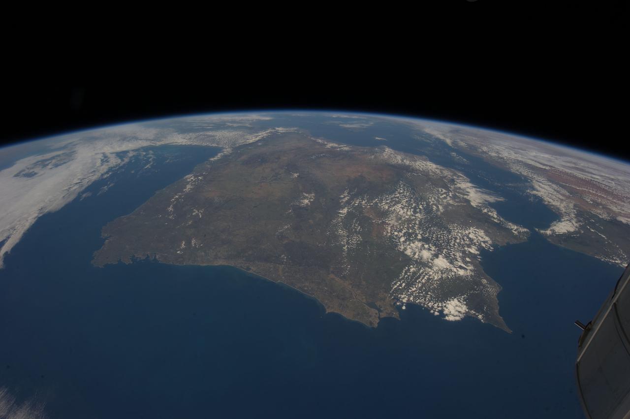
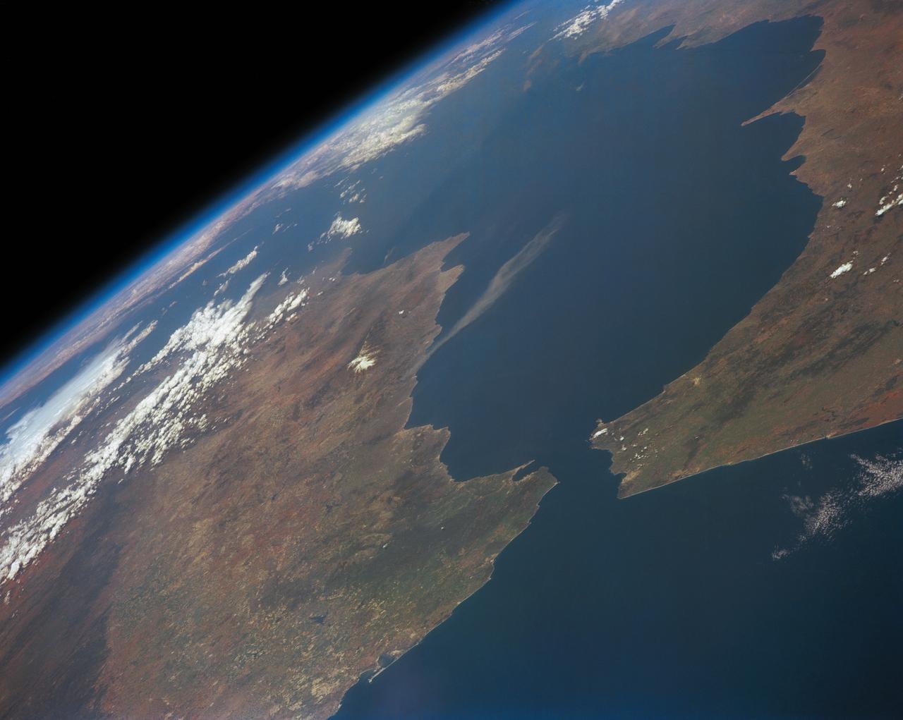
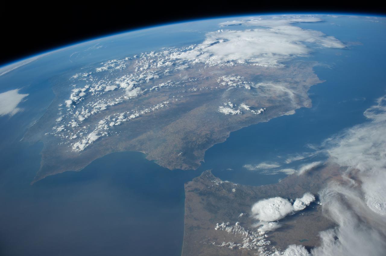
ISS035-E-027420 (23 April 2013) --- One of the Expedition 35 crew members aboard the International Space Station photographed this high oblique image of the Iberian Peninsula on April 23, 2013. This is one of the very few pictures in the history of the decades old NASA-managed human-tended space program that shows the entire peninsula, with Portugal, Spain and Gibraltar. The Strait of Gibraltar (right center) is a narrow strait that connects the Atlantic Ocean to the Mediterranean Sea and separates Gibraltar and Spain in Europe from Morocco (far right center)in Africa. Europe and Africa are separated by 7.7 nautical miles (14.3 kilometers or 8.9 statute miles) of ocean at the strait's narrowest point. A small part of France is barely visible at the horizon (top center).
iss068e053710 (Feb. 14, 2023) --- The northern portion of Turkey's Bosporus Strait, crossed by the Yavuz Sultan Selim Bridge, leads into the Black Sea in this photograph from the International Space Station as it orbited 264 miles above.
iss066e153994 (Feb. 26, 2022) --- The city lights of Sharjah and Ajman are pictured during an orbital night pass as the International Space Station orbited 261 miles above the northeastern tip of the United Arab Emirates near the Strait of Hormuz.
iss066e158512 (March 8, 2022) --- Quanzhou, a port city on China's Taiwan Strait, split by the Jinjiang River, is pictured during an orbital night pass from the International Space Station at an altitude of 262 miles above the Asian nation.
ISS040-E-011996 (14 June 2014) --- One of the Expedition 40 crew members aboard the Earth-orbiting International Space Station recorded this image of the Strait of Gibraltar, showing parts of Morocco and Spain, on June 14, 2014.
iss069e032977 (July 18, 2023) --- The city lights of the oasis city of Al Ain in the United Arab Emirates are pictured from the International Space Station as it orbited 260 miles above southern Iran near the coast of the Strait of Hormuz.
iss067e213409 (July 30, 2022) --- The city of Istanbul, Turkey, is separated by the Bosphorus Strait and sits in between the Black Sea (top) and the Sea of Marmara (bottom) in this photograph from the International Space Station as it orbited 259 miles above.
iss063e002679 (April 23, 2020) --- The northern tip of the Middle Eastern nation of Oman is pictured on the Strait of Hormuz. The International Space Station was orbiting above the Persian Gulf when this photograph was taken.
ISS040-E-010889 (12 June 2014) --- One of the Expedition 40 crew members aboard the Earth-orbiting International Space Station recorded this image of the Strait of Gibraltar, showing parts of Morocco and Spain, on June 12, 2014.

iss071e620932 (Aug. 20, 2024) --- Lightning (at center) illuminates the storm clouds above China near the coast of the Taiwan Strait in this photograph from the International Space Station as it orbited 261 miles above the Asian nation.
iss065e030820 (May 10, 2021) --- The night lights of Istanbul, Turkey, split by the Bosphorus Strait and the Golden Horn, are pictured from the International Space Station as it orbited 263 miles above the Black Sea.
iss062e147381 (March 11, 2020) --- The Strait of Juan de Fuca and the Salish Sea, pictured from the International Space Station, separate the western-most border of the United States and Canada.
iss059e078914 (May 29, 2019) --- Storm clouds are seen on the southwestern coast of Yemen as the International Space Station was about to fly 254 miles over the Bab al-Mandab Strait in between the Gulf of Aden and the Red Sea.
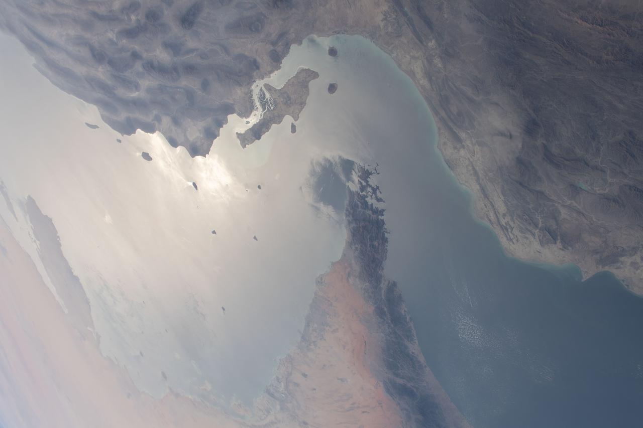
iss064e046338 (March 24, 2021) --- The strategically important shipping route of the Strait of Hormuz is pictured separating the nations of the United Arab Emirates and Iran. It also separates the main water bodies of the Persian Gulf and the Gulf of Oman.
41G-34-098 (5-13 Oct 1984) --- Strait of Gibraltar and western Mediterranean photographed sunglint. Sun reflection on water delineates surface texture, which corresponds to the ocean's dynamics. The large group of waves connecting Gibraltar with the Moroccan coast is the response of the ocean to a tidal pulse moving into the Mediterranean. The low level wing shear line extending out from the Moroccan coastline into the Mediterranean for approximately 40 miles is the southern extremity of the wind funneling through the strait. This is the first high resolution photograph ever taken of this phenomenon permitting detailed delineation of individual waves which comprise the wave packet.

KENNEDY SPACE CENTER, FLA. - U.S. Sen. Bill Nelson (right) honors the Flow Liner Inspection & Repair team for their work on repairing the flow liners on the orbiters. The team (background) comprises (left to right) Rick Beckwith, STR engineer; Mike Young, MPS engineer; Jerry Goudy, welder; Tony Nesotas, OFP-2 aft technician; and David Strait, OPF-2 orbiter inspector. Strait first spotted the fuel-line crack; Goudy performed arc welding on one of Atlantis' flow liners. Nelson presented gold seal Senate certificates to the team.
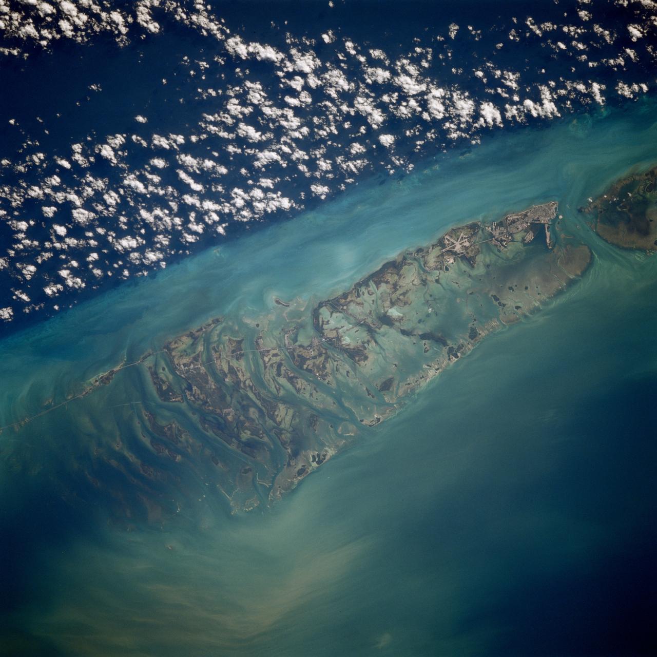
STS080-709-094 (19 Nov.-7 Dec. 1996) --- This is a view of the western portion of the Florida Keys. The view shows the city of Key West, bottom mid-right, with Marathon Key, near top middle left, and the edge of the Straits of Florida, the dark water on the right edge. Clouds form over the cooler waters of the strait. The runways at Boca Chica Key Naval Air Station are seen near Key West. The bottom can be seen clearly in the shallow water, the deeper water has depths of over a half a mile. The thin line of the Overseas Highway can be traced east from Key West. Prior to a hurricane in 1935, this route was a railway line.
iss073e0763866 (Sept. 21, 2025) --- The Southeast Asian city-state of Singapore (center), separated from Johor Bahru, Malaysia (left), by the Johor Strait, is pictured at approximately 12:34 a.m. from the International Space Station as it orbited 260 miles above. Singapore Changi Airport (right center) sits along the Straits of Singapore and features the world’s tallest indoor waterfall and a forest with over 2,000 trees and 100,000 shrubs. The bright rectangular area at bottom center is Pasir Panjang Terminal, designed to accommodate some of the world’s largest container vessels.
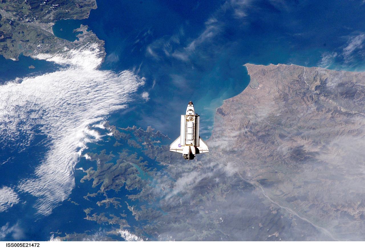
ISS005-E-21472 (25 November 2002) --- The Space Shuttle Endeavour is backdropped over Cook Strait, New Zealand as it approaches the International Space Station (ISS) during STS-113 rendezvous and docking operations. Docking occurred at 3:59 p.m. (CST) on November 25, 2002. The Port One (P1) truss, which was later to be attached to the station and outfitted during three spacewalks, can be seen in Endeavour's cargo bay. Endeavour's namesake, and her captain, First Lieutenant James Cook, moved through the waters of Cook Strait for the first time on Feb. 7, 1770.

KENNEDY SPACE CENTER, FLA. -- U.S. Sen. Bill Nelson (front) presents gold seal Senate certificates to the Flow Liner Inspection & Repair team for their work on repairing the flow liners on the orbiters. The team (background) comprises (left to right) Rick Beckwith, STR engineer; Mike Young, MPS engineer; Jerry Goudy, welder; Tony Nesotas, OFP-2 aft technician; and David Strait, OPF-2 orbiter inspector. Strait first spotted the fuel-line crack; Goudy performed arc welding on one of Atlantis' flow liners.
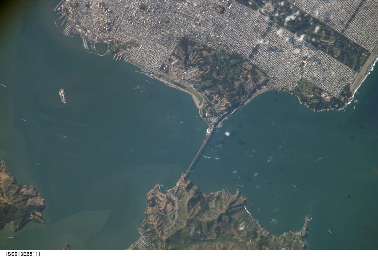
ISS013-E-65111 (6 Aug. 2006) --- Golden Gate, San Francisco, CA is featured in this image photographed by an Expedition 13 crewmember on the International Space Station. The Golden Gate of San Francisco Bay is one of the most recognizable straits in the world due to the Golden Gate Bridge that spans it. This image is a nearly cloud-free view of the northern San Francisco metropolitan area. The gridded pattern of streets, residential neighborhoods, and high-rise commercial blocks is clearly evident in the top half of the image. The twin support towers of the Golden Gate Bridge and its distinctive orange paint scheme can also be distinguished. The vegetated landscape of a portion of the Golden Gate National Recreation Area (green rectangular region at image center) connects the Bridge with steep, less vegetated hill slopes south of the city of Sausalito across the strait. Other features in this view include the former prison of Alcatraz, located on the island of the same name. Numerous boat wakes of commercial and pleasure craft are visible beneath and to the west of the Bridge. The shadow of the roadbed of the Bridge can be seen directly to the west of the Bridge itself. Regions of greenish-brown water visible in San Francisco Bay mark water masses with differing amounts of suspended sediment that are streamlined by the strong tidal currents that flow through the strait.
iss067e035819 (May 7, 2022) --- The Canadian provinces of Nova Scotia, Prince Edward Island, and New Brunswick, are pictured from the International Space Station as it orbited 260 miles above the North American continent. The major bodies of water seen in the photograph (from right) are the Gulf of St. Lawrence, Northumberland Strait, and New London Bay.
ISS040-E-016324 (20 June 2014) --- One of the Expedition 40 crew members aboard the Earth-orbiting International Space Station recorded this oblique panorama of the Strait of Gibraltar, showing parts of Morocco and Spain, on June 20, 2014.
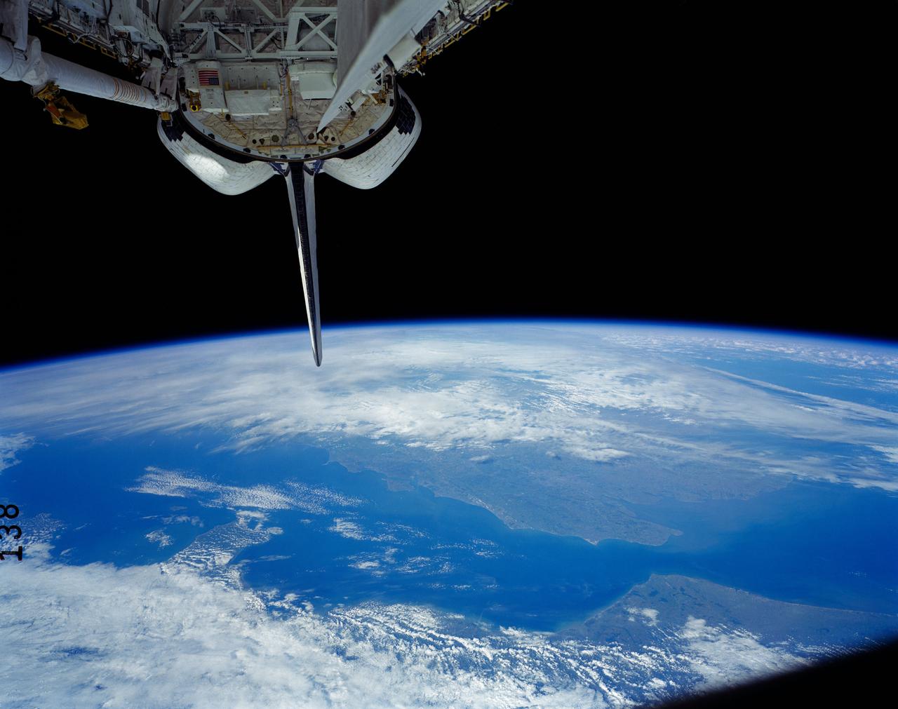
41G-121-138 (5-13 Oct 1984) --- A view of the Earth's horizon featuring France and England. The Strait of Dover and the English channel are visible behind the tail (vertical stabilizer) of Challenger. The remote manipulator system (RMS arm rests in its "stow" position at upper left corner.
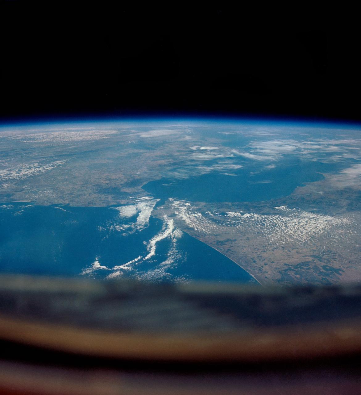
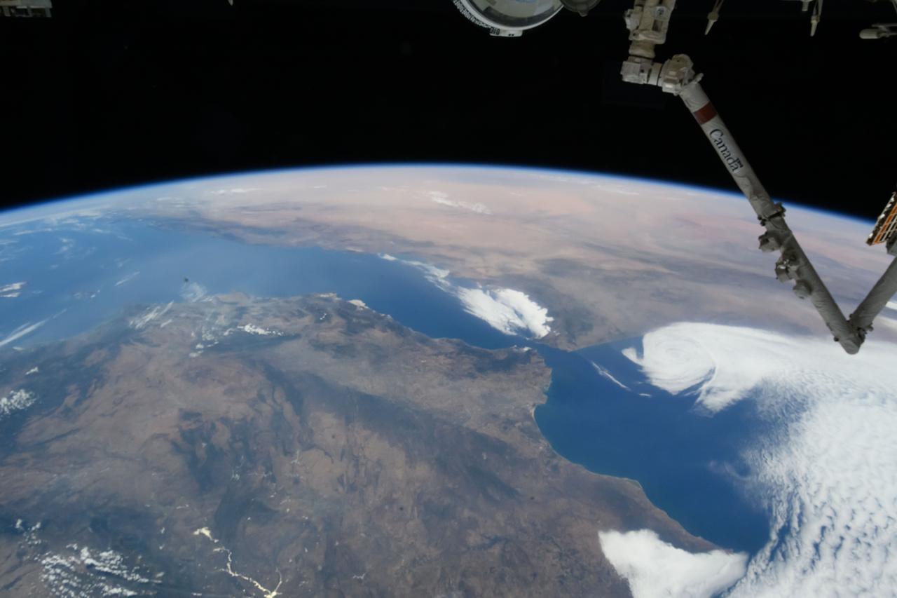
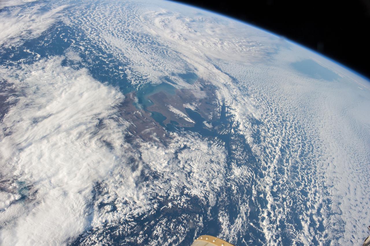
iss059e038134 (April 30, 2019) --- Looking from northwest to southeast (bottom to top), this oblique view shows portions of Western Europe, the Atlantic Ocean, the Mediterranean Sea and North Africa. More specific regions such as Portugal, Spain, the Strait of Gibraltar, Morocco and Algeria are seen as the International Space Station orbited 257 miles above the Atlantic.
iss072e399852 (Dec. 20, 2024) --- The city lights of Busan, South Korea, a port city with a population of over 3.3 million on the Korean Strait, are pictured at approximately 4:19 a.m. local time from the International Space Station as it orbited 257 miles above.
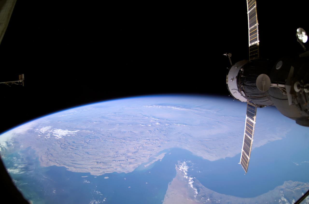
ISS008-E-12570 (22 January 2004) --- Backdropped by Earth’s horizon and the blackness of space, an unpiloted Progress supply vehicle docked to the International Space Station (ISS) was photographed by one of the Expedition 8 crewmembers. Parts of Iran, the United Arab Emirates, Oman, Strait of Hormuz and the Persian Gulf are also visible.
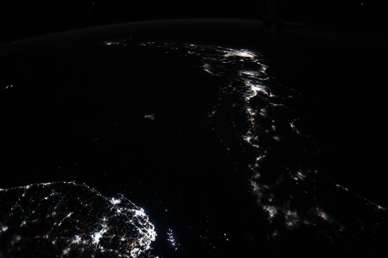
iss073e0686324 (Aug. 30, 2025) --- The nighttime coastal lights of Morocco and Spain, where the Atlantic Ocean meets the Mediterranean Sea at the Strait of Gibraltar, are pictured at approximately 1:36 a.m. local time as the International Space Station orbited 260 miles above the Moroccan coast.
S66-46044 (18-21 July 1966) --- Straits of Gibraltar and Spain ? Portugal (left), Morocco (right), Atlantic Ocean (foreground), and unique vortex, as seen from the Gemini-10 spacecraft. Taken with J.A. Maurer 70mm camera, using Eastman Kodak, Ektachrome, MS (S.O. 217) color film. Photo credit: NASA
iss062e005579 (Feb. 11, 2020) --- The Strait of Gibraltar connects the Atlantic Ocean with the Mediterranean Sea and separates Spain on the European continent from Morocco on the African continent. The International Space Station was orbiting 265 miles above the Atlantic off the coast of Lisbon, Portugal, when this photograph was taken.

iss069e056918 (Aug. 14, 2023) --- The Strait of Hormuz (bottom left) connects the Gulf of Oman with the Persian Gulf in this photograph from the International Space Station as it orbited 262 miles above southwestern Iran. In the right foreground, is the Northrop Grumman Cygnus space freighter and one of its cymbal-shaped UltraFlex solar arrays.
ISS047e001308 (03/02/2016) --- Europe meets Africa in this Earth Observation image captured by NASA astronaut Tim Peake. He tweeted this message out with the photo " Strait of Gibraltar - 9 miles separating #Europe and #Africa . @Space_Station #Explore ".
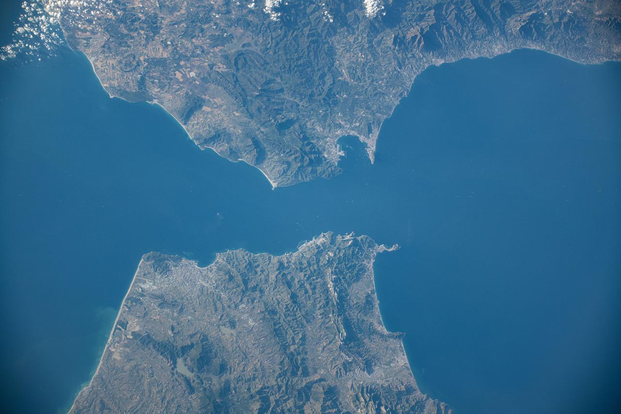
iss071e217183 (June 25, 2024) -- As the International Space Station orbited 263 miles above Earth, NASA astronaut Butch Wilmore captured this image of Spain and Morocco. The Strait of Gibraltar separates the two countries and connects the Atlantic Ocean to the Mediterranean Sea.
iss065e001923 (April 22, 2021) --- Istanbul, Turkey, connects Europe and Asia and is split by the Golden Horn and the Bosphorus Strait which links the Sea of Marmara to the Black Sea. The International Space Station was orbiting 264 miles above Turkey just southwest of its capital city, Ankara, at the time this photograph was taken.
iss069e086298 (Aug. 27, 2023) --- This view of Earth was captured from a window on the SpaceX Dragon Endurance spacecraft as it approached the International Space Station. Pictured below is the Strait of Gibraltar that connects the Atlantic Ocean to the Mediterranean Sea, which separates the continents of Europe and Africa.
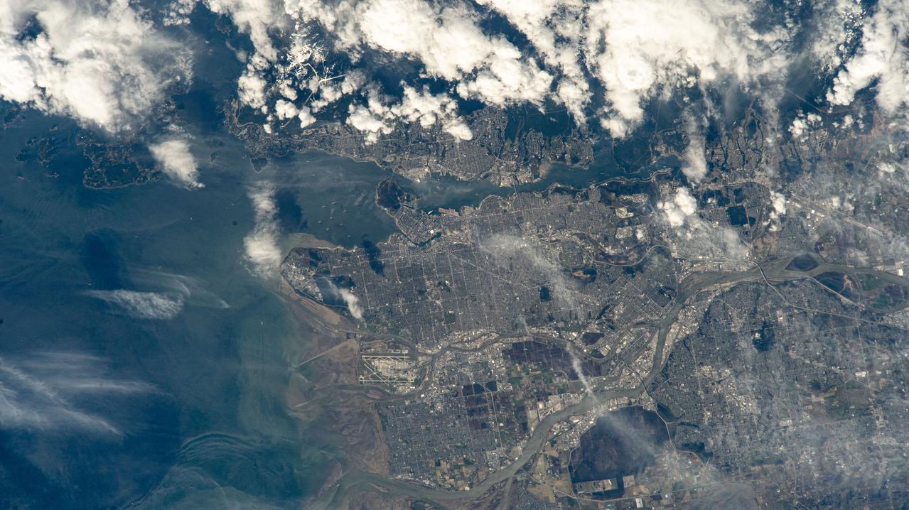
iss071e006133 (April 9, 2024) --- Vancouver, British Columbia, and its surroundng suburbs on the Strait of Georgia are pictured from the International Space Station as it orbited 261 miles above Canada. Toward lower center, is the Fairmont Vancouver Airport on Sea Island.
Earth Observation taken during a day pass by the Expedition 40 crew aboard the International Space Station (ISS). Folder lists this as:Straights of Magellan - Atlantic entrance - Clearish skies. Also sent down as Twitter message: Atlantic entrance to the Straits of Magellan. Prettiest place I've ever been.
iss071e082829 (May 16, 2024) --- The Strait of Gibraltar separates the European nation of Spain from the African nation of Morocco and connects the Atlantic Ocean with the Medirrranean Sea. The International Space Station was orbiting 259 miles above North Africa at the time of this photograph.
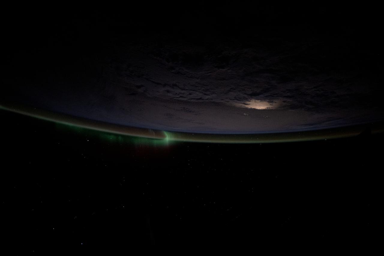
iss073e0036151 (April 20, 2025) --- A wispy aurora intersects with Earth's atmospheric glow as a slight moon glint beams off a cloudy Southern Ocean. The International Space Station was orbiting 269 miles above the Bass Strait off the coast of Tasmania at the time of this photograph.
S66-45951 (18-21 July 1966) --- China, Fukien and Kwangtung provinces, Formosa Strait, Pescadores Island, Quemoy Island, as seen from the Gemini-10 spacecraft. Taken with a J.A. Maurer 70mm camera, using Eastman Kodak, Ektachrome, MS (S.O. 217) color film. Photo credit: NASA
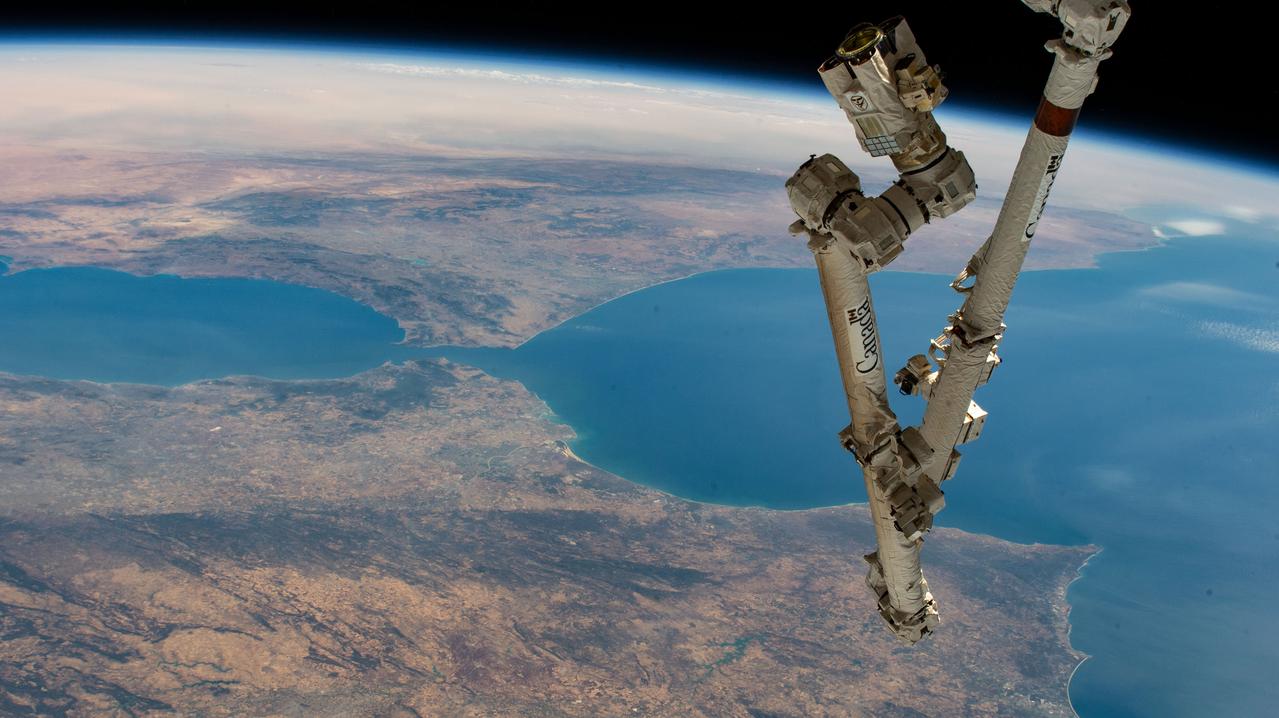
iss067e270597 (Aug. 18, 2022) --- The Canadarm2 robotic arm extends from the International Space Station, orbiting 259 miles above the northern coast of Spain, in this photograph of the Strait of Gibraltar which separates the Atlantic Ocean (right) from the Mediterranean Sea and the European nation of Spain (bottom) from the African country of Morocco.
iss072e398901 (Dec. 19, 2024) --- The city lights of Maracaibo, Venezuela, with a population of 2.66 million residents on the strait between Lake Maracaibo and the Gulf of Venezuela, are pictured at approximately 3:28 a.m. local time from the International Space Station as it orbited 255 miles above.
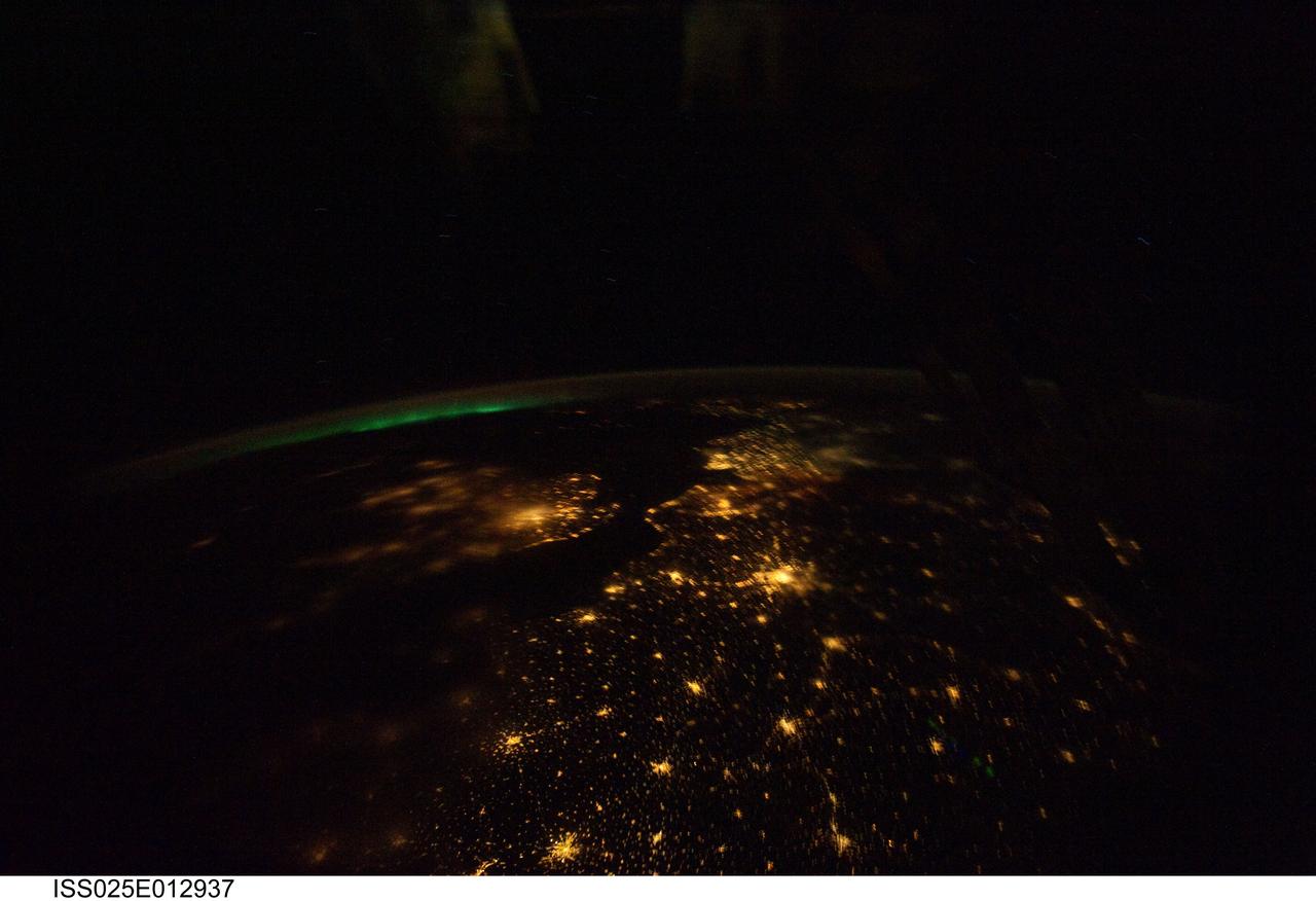
ISS025-E-012937 (7 Nov. 2010) --- Aurora Borealis sits on the horizon of this night view over much of Europe. The Strait of Dover is relatively clear as is Paris, the City of Lights. There is some fog over the western part of England and London.
iss067e270600 (Aug. 18, 2022) --- The Strait of Hormuz connects the Gulf of Oman (left) with the Persian Gulf (right). The waterway also separates the Middle Eastern nation of Iran (bottom) from the Arabian Peninsula nations of Oman, United Arab Emirates, and Qatar (top left to right).
iss056e084388 (July 6, 2018) --- The eastern-flowing Amur River forms a portion of the border between northeastern China and far eastern Russia. At the time of this photograph, the International Space Station was orbiting almost 257 miles above the Strait of Tartary which separates mainland Asia from the Russian island of Sakhalin.

KENNEDY SPACE CENTER, FLA. - Bob Herman,chief engineer, Ground Operations for United Space Alliance (USA), shows U.S. Sen. Bill Nelson (center) part of orbiter Atlantis. Nelson was at KSC to present gold seal Senate certificates to the Flow Liner Inspection & Repair team for their part in finding the cracks in orbiter flow liners and repairing them. Team members are (behind Herman and Nelson, left to right) Mike Young, Jerry Goudy, Rick Beckwith, Tony Nesotas and David Strait. Goudy performed arc welding on one of Atlantis' flow liners; Strait found the original crack. In the foreground are Shuttle Engineering Director, USA, Mark Nappi; Center Director Roy Bridges; and vice president and deputy program manager, Florida Operations, USA, Bill Pickavance.
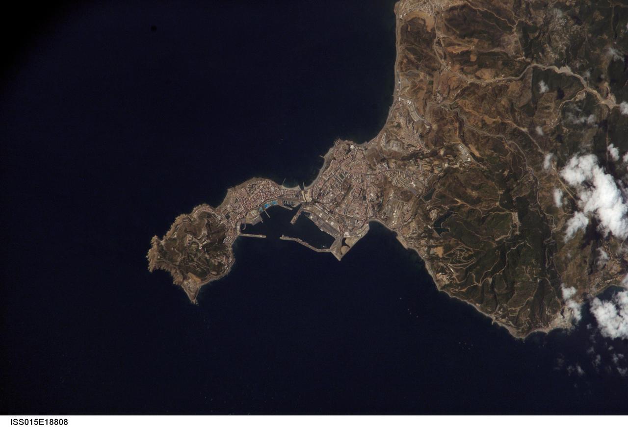
ISS015-E-18808 (21 July 2007) --- Ceuta on the northern African coastline is featured in this image photographed by an Expedition 15 crewmember on the International Space Station. The small Spanish enclave of Ceuta occupies a narrow isthmus of land on the African side of the Strait of Gibraltar. This view illustrates the sharp contrast in land cover between urban Ceuta (pink to white residential and industrial rooftops at center), the bay formed by seawalls to the north of the city, and the higher elevations of Monte Hacho forming the end of the isthmus. Green, vegetated slopes surround the Spanish fort atop the mountain, which commands a clear view of the Strait of Gibraltar to the northwest (not shown). Several small dots are visible near the coastline to the northwest and south of Ceuta -- these are small pleasure or fishing boats.
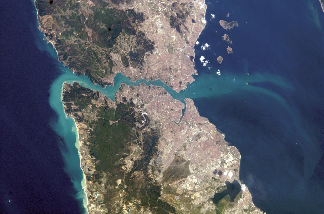
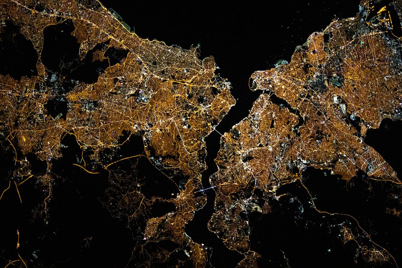
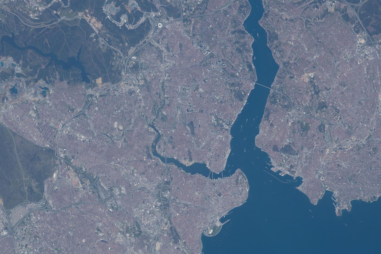
ISS008-E-21752 (16 April 2004) --- This image featuring Istanbul, Turkey was photographed by an Expedition 8 crewmember on the International Space Station (ISS). This metropolis of 15 million occupies both sides of the entrance to the narrow, 20-mile long Bosporus Strait connecting the Mediterranean and Sea of Marmara (south) to the Black Sea (north). When this image was taken, strong currents carried turbid coastal waters from the Black Sea through the Strait and into the Sea of Marmara. The rugged uplands to the north of the city are forested and contain vital reservoirs. Note Ataturk airport southwest of the city near the bottom of the image, the picturesque Prince Islands in the Sea of Marmara, and the sinuous waterway and harbor on the western shore known as the Golden Horn.