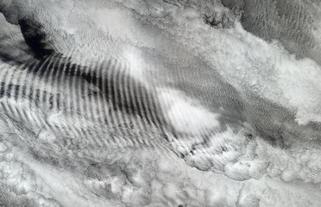
In this natural-color image from NASA Terra spacecraft, a fingerprint-like gravity wave feature occurs over a deck of marine stratocumulus clouds.
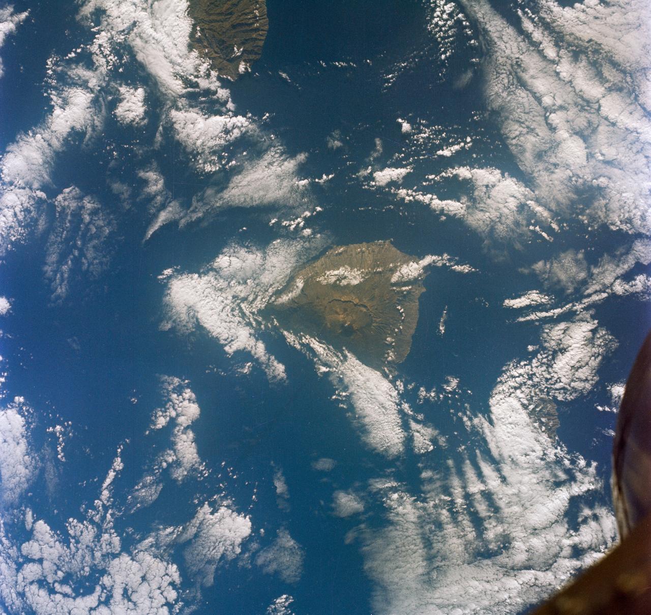
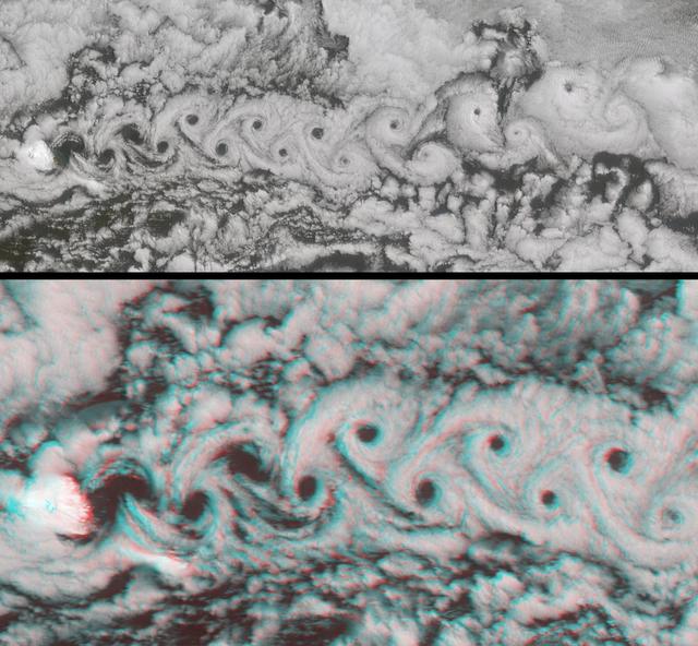
S65-63150 (16 Dec. 1965) --- Eddies in stratocumulus clouds over the Canary Islands as seen from the Gemini-6 spacecraft during its 14th revolution of Earth. Photo credit: NASA or National Aeronautics and Space Administration
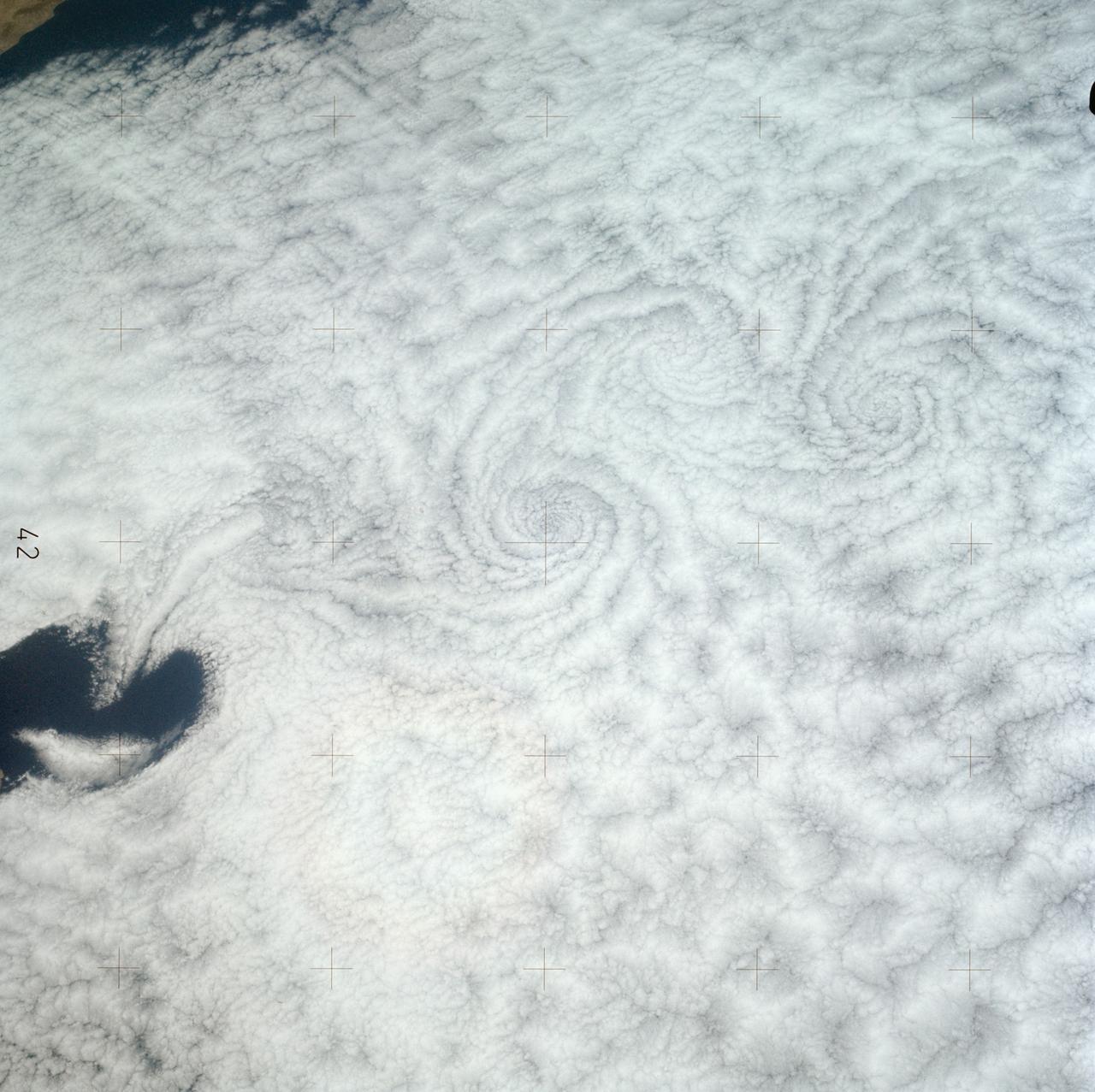
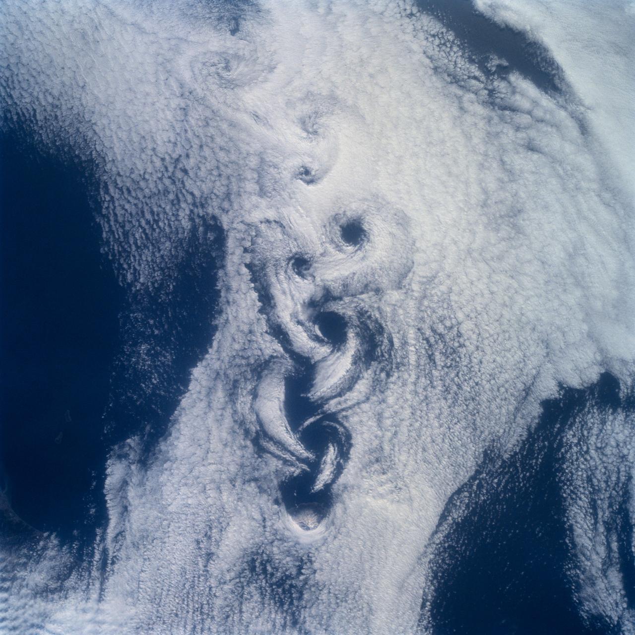
SL3-121-2371 (July-September 1973) --- A pattern of downstream eddies in the stratocumulus clouds over the Pacific Ocean west of Baja California, as photographed by the crewmen of the second Skylab manned mission (Skylab 3) from the space station cluster in Earth orbit. The clouds, produced by the cold California current running to the south and southwest, are prevented from rising by warm air above them. Photo credit: NASA
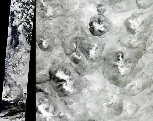
NASA Terra satellite shows the shape and size of cellular patterns within marine stratocumulus cloud layers can change dramatically with the prevailing meteorological conditions.
Marine stratocumulus clouds frequently form parallel rows, or cloud streets, along the direction of wind flow. NASA Terra spacecraft captured this stereo image of Jan Mayen island Beerenberg volcano. 3D glasses are necessary to view this image.
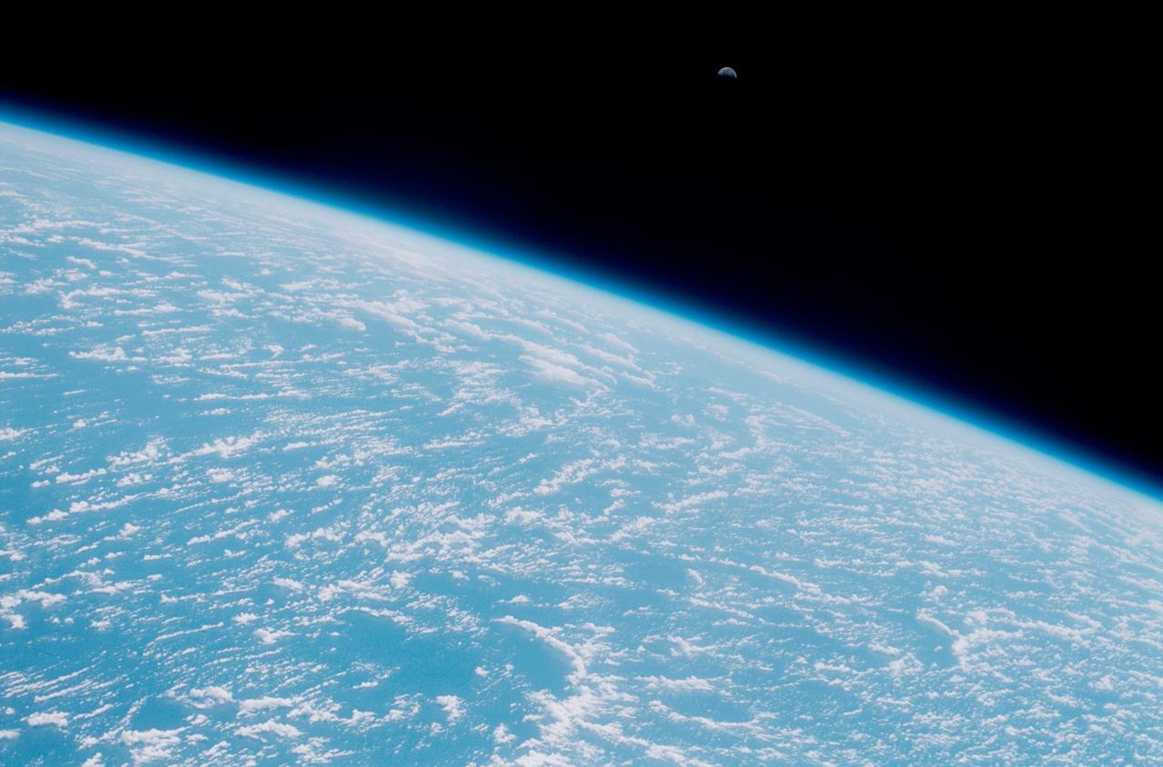
STS102-324-028 (16 March 2001) --- The moon and Earth's limb were viewed from the Space Shuttle Discovery as it flew over the central Pacific Ocean with stratocumulus clouds below.

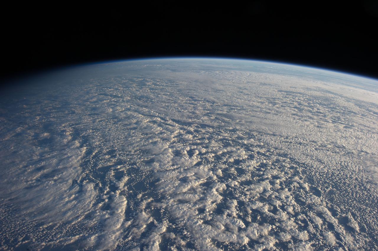
ISS036-E-039811 (30 Aug. 2013) --- One of the Expedition 36 crew members aboard the International Space Station photographed this unusual image of what appear to be either stratocumulus or altocumulus clouds off the coast of southern California on Aug. 30, 2013.
ISS034-E-016601 (4 Jan. 2013) --- On Jan. 4 a large presence of stratocumulus clouds was the central focus of camera lenses which remained aimed at the clouds as the Expedition 34 crew members aboard the International Space Station flew above the northwestern Pacific Ocean about 460 miles east of northern Honshu, Japan. This is a descending pass with a panoramic view looking southeast in late afternoon light with the terminator (upper left). The cloud pattern is typical for this part of the world. The low clouds carry cold air over a warmer sea with no discernable storm pattern.
STS100-710-182 (19 April-1 May 2001) --- Easily recognizable in this STS-100 70mm frame are phenomena known as the von Karman vortices, which were forming in the stratocumulus field downwind from the volcanic island of Rishiri-to in the northern Sea of Japan off the northwest coast of Hokkaido, Japan. According to NASA scientists studying the STS-100 photo collection, these features form when a stable atmosphere with low clouds flows past a relatively small obstacle with a height greater than the depth of the cloud layer. Because the atmosphere is stable, a series of eddies form in the moving cloud field.

NOAA's GOES-15 satellite captured the southern California "June Gloom" on June 10, 2013. That's a weather pattern that creates cloudy, overcast skies and cool temperatures. The "June Gloom" of low lying stratus clouds form over the ocean and can be pushed to coastal areas by wind. It usually happens off the west coast of California during the late spring and early summer. As for the "seam" of blue within the "June Gloom," it appears to be actinoform clouds, a seam in the marine stratocumulus aka "June Gloom" of southern California. Actinoform clouds and marine stratus in general are only marginally stable. Sometimes the cloud deck spontaneously dissolves along a line by drizzling out the moisture. This seam is an unusually long curve that is not identified with a coastline or a weather front. Dennis Chesters/Rob Gutro NASA's Goddard Space Flight Center, Greenbelt, Md. REFERENCES <a href="http://en.wikipedia.org/wiki/Actinoform_cloud" rel="nofollow">en.wikipedia.org/wiki/Actinoform_cloud</a> <a href="http://en.wikipedia.org/wiki/June_Gloom" rel="nofollow">en.wikipedia.org/wiki/June_Gloom</a> <b><a href="http://www.nasa.gov/audience/formedia/features/MP_Photo_Guidelines.html" rel="nofollow">NASA image use policy.</a></b> <b><a href="http://www.nasa.gov/centers/goddard/home/index.html" rel="nofollow">NASA Goddard Space Flight Center</a></b> enables NASA’s mission through four scientific endeavors: Earth Science, Heliophysics, Solar System Exploration, and Astrophysics. Goddard plays a leading role in NASA’s accomplishments by contributing compelling scientific knowledge to advance the Agency’s mission. <b>Follow us on <a href="http://twitter.com/NASA_GoddardPix" rel="nofollow">Twitter</a></b> <b>Like us on <a href="http://www.facebook.com/pages/Greenbelt-MD/NASA-Goddard/395013845897?ref=tsd" rel="nofollow">Facebook</a></b> <b>Find us on <a href="http://instagram.com/nasagoddard?vm=grid" rel="nofollow">Instagram</a></b>
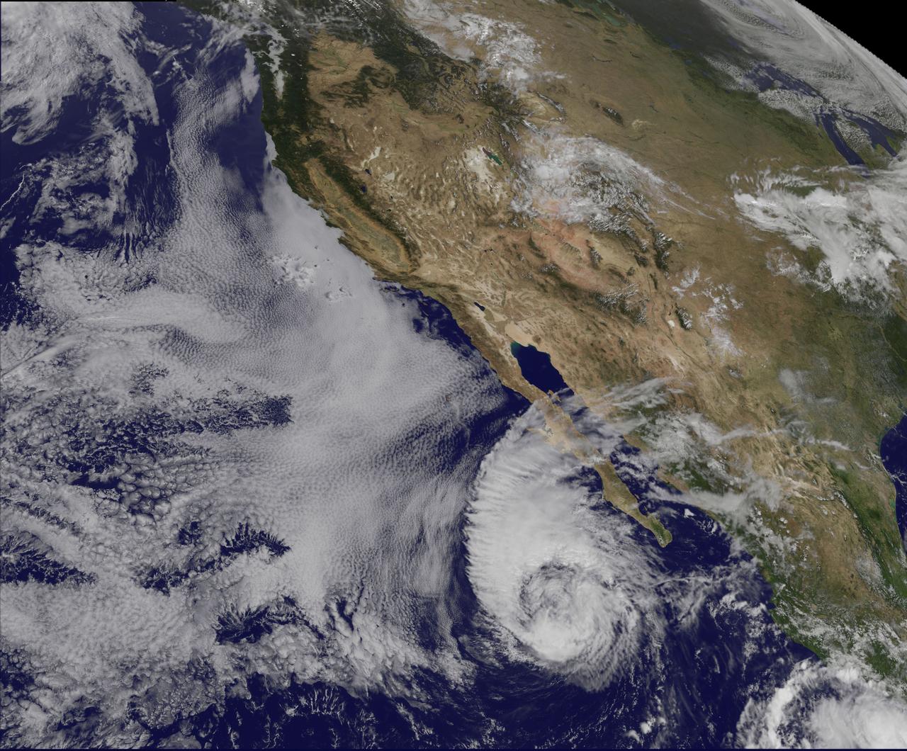
This visible image of Tropical Storm Miriam was captured by NOAA's GOES-15 satellite on Sept. 26, 2012 at 10:45 a.m. EDT off the coast of Baja California. The strongest thunderstorms were in a large band of thunderstorms north and northwest of the center. Miriam is banked to the north and west by an extensive field of stratocumulus clouds. Credit: NASA/NOAA GOES Project ---- Once a powerful hurricane, Miriam is now a tropical storm off the coast of Baja California, Mexico. Tropical Storm Miriam was seen in the Eastern Pacific Ocean by NOAA's GOES-15 satellite, and the visible image revealed that the strongest part of the storm was north and west of the center. NOAA's GOES-15 satellite sits in a fixed position over the western U.S. that allows it to monitor the Eastern Pacific Ocean and it captured a visible image of Tropical Storm Miriam on Sept. 26, 2012 at 10:45 a.m. EDT off the coast of Baja California. The strongest thunderstorms were north and northwest of the center in a large band, wrapping around the center of the tropical storm. Miriam is banked to the north and west by an extensive field of stratocumulus clouds Wind shear is taking its toll on Miriam. The National Hurricane Center noted there is an increasing "separation between the low- to mid-level centers of the storm (think of the storm as having multiple layers) due to 20-25 knots of southwesterly shear associated with a shortwave trough (elongated area of low pressure) rotating around the northwestern side of the storm. At 11 a.m. EDT on Sept. 26, Tropical Storm Miriam had maximum sustained winds near 65 mph (100 kph), dropping from 70 mph (100 kmh) just six hours before. It was located about 425 miles (680 km) west-southwest of the southern tip of Baja California Miriam was moving slowly at 6 mph (9 kmh) to the north-northwest and away from the coast. Miriam's minimum central pressure was near 992 millibars. A Miriam continues to pull away from Baja California, rough ocean swells will keep affecting the south and west coasts today, Sept. 26, and tomorrow, Sept. 27. By Sept. 28, Friday, the ocean swells will gradually begin to subside. Miriam is moving into a region where wind shear is forecast to increase and sea surface temperatures will fall. Those are two factors that will contribute to the weakening of the tropical storm over the next several days. Rob Gutro NASA's Goddard Space Flight Center Image: NASA GOES Project <b><a href="http://www.nasa.gov/audience/formedia/features/MP_Photo_Guidelines.html" rel="nofollow">NASA image use policy.</a></b> <b><a href="http://www.nasa.gov/centers/goddard/home/index.html" rel="nofollow">NASA Goddard Space Flight Center</a></b> enables NASA’s mission through four scientific endeavors: Earth Science, Heliophysics, Solar System Exploration, and Astrophysics. Goddard plays a leading role in NASA’s accomplishments by contributing compelling scientific knowledge to advance the Agency’s mission. <b>Follow us on <a href="http://twitter.com/NASA_GoddardPix" rel="nofollow">Twitter</a></b> <b>Like us on <a href="http://www.facebook.com/pages/Greenbelt-MD/NASA-Goddard/395013845897?ref=tsd" rel="nofollow">Facebook</a></b> <b>Find us on <a href="http://instagrid.me/nasagoddard/?vm=grid" rel="nofollow">Instagram</a></b>
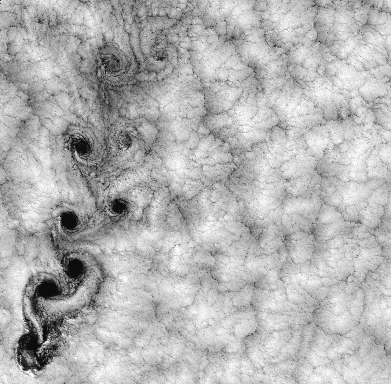
NASA image acquired September 15, 1999 This Landsat 7 image of clouds off the Chilean coast near the Juan Fernandez Islands (also known as the Robinson Crusoe Islands) on September 15, 1999, shows a unique pattern called a “von Karman vortex street.” This pattern has long been studied in the laboratory, where the vortices are created by oil flowing past a cylindrical obstacle, making a string of vortices only several tens of centimeters long. Study of this classic “flow past a circular cylinder” has been very important in the understanding of laminar and turbulent fluid flow that controls a wide variety of phenomena, from the lift under an aircraft wing to Earth’s weather. Here, the cylinder is replaced by Alejandro Selkirk Island (named after the true “Robinson Crusoe,” who was stranded here for many months in the early 1700s). The island is about 1.5 km in diameter, and rises 1.6 km into a layer of marine stratocumulus clouds. This type of cloud is important for its strong cooling of the Earth’s surface, partially counteracting the Greenhouse warming. An extended, steady equatorward wind creates vortices with clockwise flow off the eastern edge and counterclockwise flow off the western edge of the island. The vortices grow as they advect hundreds of kilometers downwind, making a street 10,000 times longer than those made in the laboratory. Observing the same phenomenon extended over such a wide range of sizes dramatizes the “fractal” nature of atmospheric convection and clouds. Fractals are characteristic of fluid flow and other dynamic systems that exhibit “chaotic” motions. Both clockwise and counter-clockwise vortices are generated by flow around the island. As the flow separates from the island’s leeward (away from the source of the wind) side, the vortices “swallow” some of the clear air over the island. (Much of the island air is cloudless due to a local “land breeze” circulation set up by the larger heat capacity of the waters surrounding the island.) The “swallowed” gulps of clear island air get carried along within the vortices, but these are soon mixed into the surrounding clouds. Landsat is unique in its ability to image both the small-scale eddies that mix clear and cloudy air, down to the 30 meter pixel size of Landsat, but also having a wide enough field-of-view, 180 km, to reveal the connection of the turbulence to large-scale flows such as the subtropical oceanic gyres. Landsat 7, with its new onboard digital recorder, has extended this capability away from the few Landsat ground stations to remote areas such as Alejandro Island, and thus is gradually providing a global dynamic picture of evolving human-scale phenomena. For more details on von Karman vortices, refer to <a href="http://climate.gsfc.nasa.gov/~cahalan" rel="nofollow">climate.gsfc.nasa.gov/~cahalan</a>. Image and caption courtesy Bob Cahalan, NASA GSFC Instrument: Landsat 7 - ETM+ Credit: NASA/GSFC/Landsat <b><a href="http://www.nasa.gov/centers/goddard/home/index.html" rel="nofollow">NASA Goddard Space Flight Center</a></b> enables NASA’s mission through four scientific endeavors: Earth Science, Heliophysics, Solar System Exploration, and Astrophysics. Goddard plays a leading role in NASA’s accomplishments by contributing compelling scientific knowledge to advance the Agency’s mission. <b>Follow us on <a href="http://twitter.com/NASA_GoddardPix" rel="nofollow">Twitter</a></b> <b>Join us on <a href="http://www.facebook.com/pages/Greenbelt-MD/NASA-Goddard/395013845897?ref=tsd" rel="nofollow">Facebook</a></b>
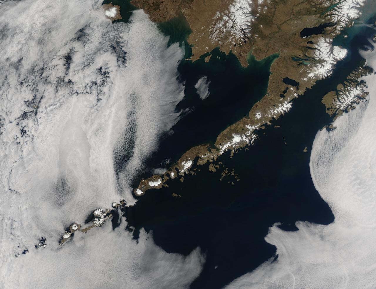
Remote, rugged and extraordinarily beautiful, Alaska’s Aleutian Islands are best known for wildlife reserves, military bases, fishing, furs and fog. The sprawling volcanic archipelago was brought into the spotlight by the Russian-supported expedition of Alexey Chirikov and Vitus Bering in 1741, and soon became controlled by the Russian-American Fur Company. In 1867 the United States purchased Alaska, including the Aleutian Islands, from Russia. By 1900 the port in Unalaska was well established as a shipping port for Alaska gold. The archipelago sweeps about 1,200 miles (1,800 km) from the tip of the Alaskan Peninsula to Attu, the most westward island. Four major island groups hold 14 large islands, about 55 smaller islands, and a large number of islets, adding up to roughly 150 islands/islets in total. This chain separates the Bering Sea (north) from the Pacific Ocean (south) and the islands are connected by the Marine Highway Ferry – at least as far as Unalaska. For the most remote islands, such as birding paradise of Attu, the western-most Aleutian Island, travel becomes trickier and relies primarily on custom charter. The Moderate Resolution Imaging Spectroradiometer (MODIS) flew over the region and captured this spectacular true-color image of the eastern Aleutian Islands on May 15, 2014. In this image, the Alaskan Peninsula protrudes from the mainland and sweeps to the southwest. The first set of islands are called the Fox Island group. Unalaska Island is part of this group and can be identified, with some imagination, as an island formed in the shape of a flying cherub, with two arms (peninsulas) outstretched towards the northeast, seemingly reaching for the round “balls” of Akutan and Akun Islands. The smallest islands in the west of the image belong to the group known as the Islands of Four Mountains. The Aleutians continue far to the west of this image. Fog surrounds the Aleutians, stretching from just off the southwestern Alaska mainland to the western Fox Islands group, then further southwest across the Pacific Ocean. It appears to give way to marine stratocumulus clouds in the west. Fog is common in the area, and can be a hazard to shipping. Credit: NASA/GSFC/Jeff Schmaltz/MODIS Land Rapid Response Team <b><a href="http://www.nasa.gov/audience/formedia/features/MP_Photo_Guidelines.html" rel="nofollow">NASA image use policy.</a></b> <b><a href="http://www.nasa.gov/centers/goddard/home/index.html" rel="nofollow">NASA Goddard Space Flight Center</a></b> enables NASA’s mission through four scientific endeavors: Earth Science, Heliophysics, Solar System Exploration, and Astrophysics. Goddard plays a leading role in NASA’s accomplishments by contributing compelling scientific knowledge to advance the Agency’s mission. <b>Follow us on <a href="http://twitter.com/NASAGoddardPix" rel="nofollow">Twitter</a></b> <b>Like us on <a href="http://www.facebook.com/pages/Greenbelt-MD/NASA-Goddard/395013845897?ref=tsd" rel="nofollow">Facebook</a></b> <b>Find us on <a href="http://instagram.com/nasagoddard?vm=grid" rel="nofollow">Instagram</a></b>