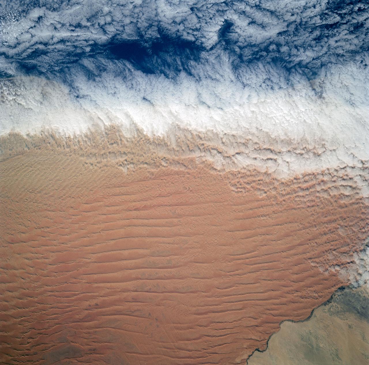
Fog is the only source of moisture for desert dwelling animals and plants living in the Namib Desert sand dune field, Namibia (23.5N, 15.0E). Coastal stratus clouds provide most of the life supporting moisture as fog droplets in this arid land where the usual annual rainfall is less than a quarter of an inch for decades at a time. In this view, the stratus clouds over the coast conform to the dune pattern proving that the fog is in ground contact.
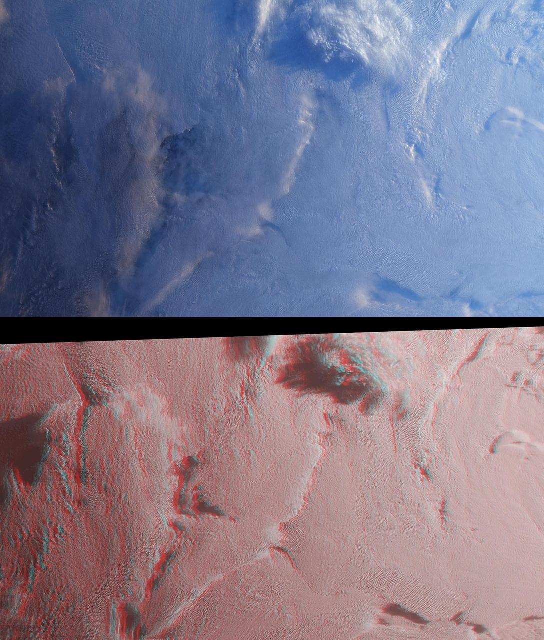
Stratus clouds are common in the Arctic during the summer months, and are important modulators of the arctic climate as seen in this anaglyph from the MISR instrument aboard NASA Terra spacecraft. 3D glasses are necessary to view this image.
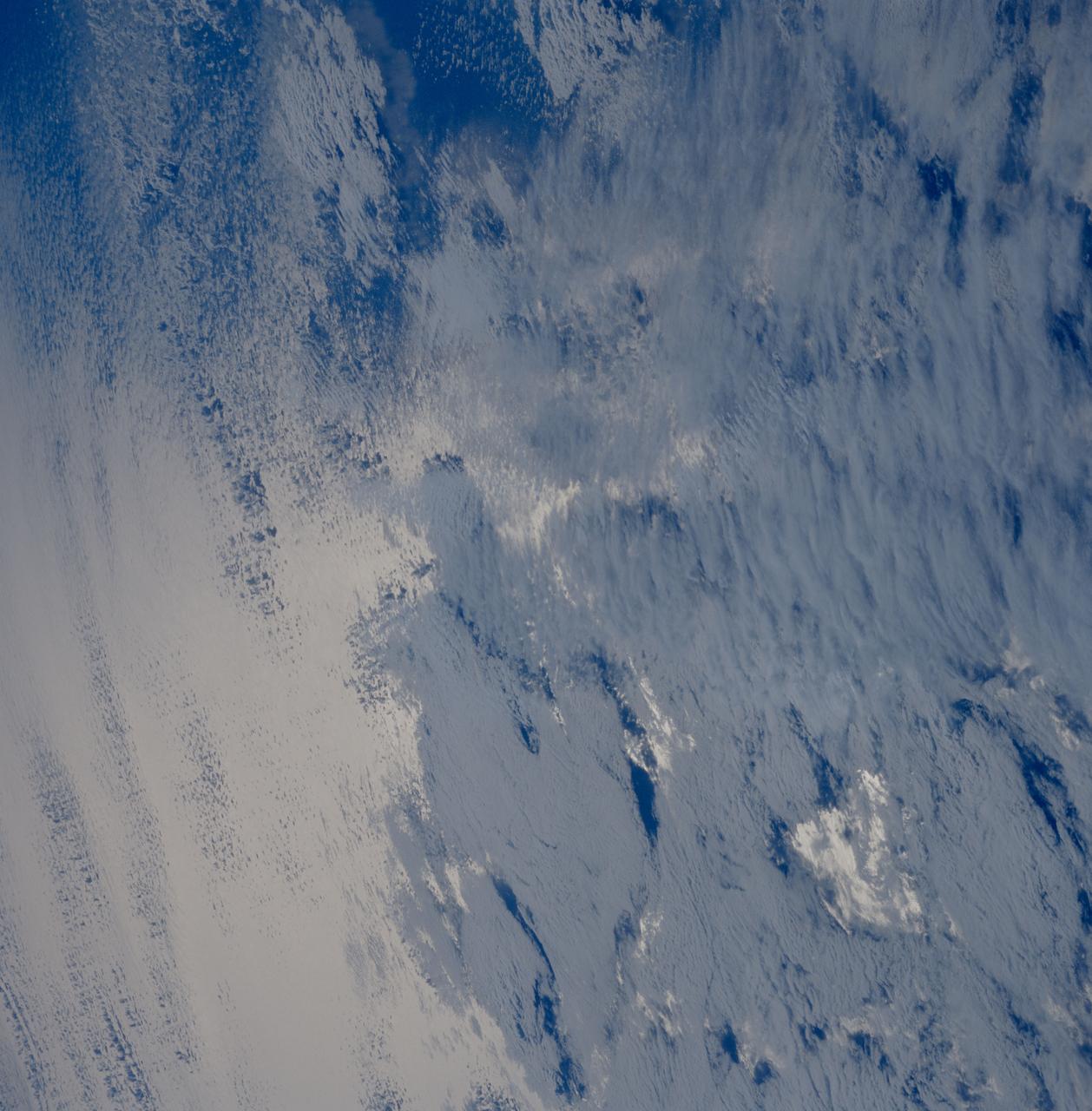
STS039-81-00BC (28 April-6 May 1991) --- A variety of stratus clouds is represented in this picture. The clouds are backdropped against the sunglinted northern Pacific Ocean. One of Discovery's seven crewmembers aimed a 70mm handheld camera through an overhead window on the aft flight deck to obtain the image.
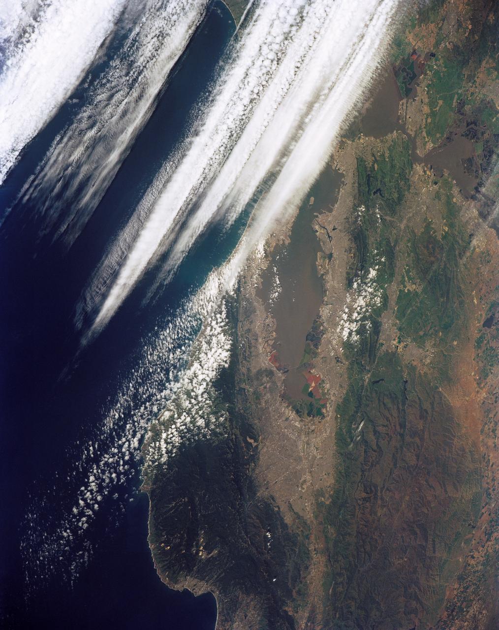
STS039-151-181A (28 April-6 May 1991) --- Large format (five-inch) frame of the San Francisco/Oakland Bay Area of northern California. Stratus clouds at 35,000 feet and cumulus clouds at about 15,000 feet are seen over the Pacific Coast, obscuring the Golden Gate Bridge.
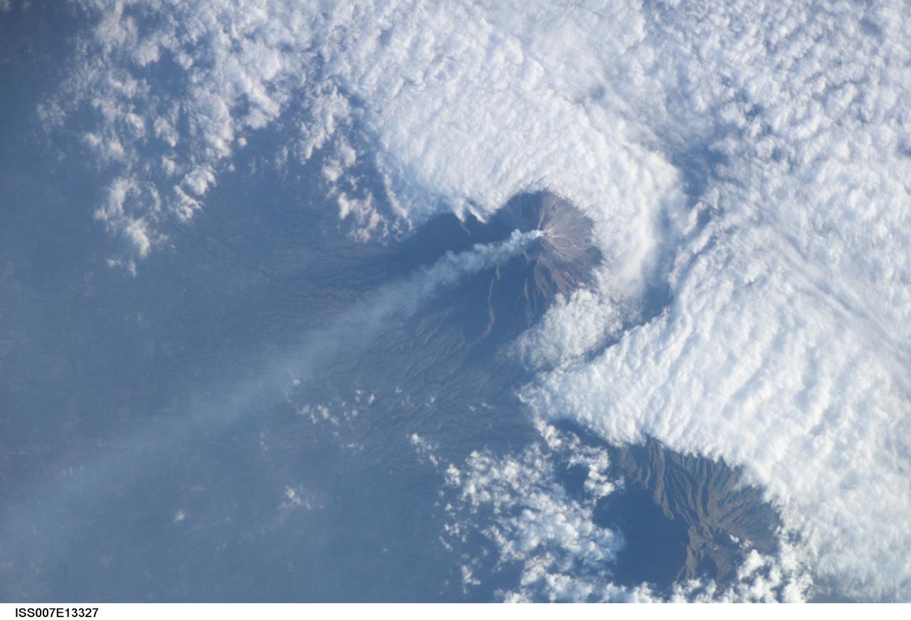
ISS007-E-13327 (24 August 2003) --- This view featuring Java’s Merapi volcano was photographed by one of the Expedition 7 crewmembers onboard the International Space Station (ISS). At 2,911 meters, the summit of Merapi and its vigorous steam plume rises above a bank of stratus clouds. One of Indonesia’s most active volcanoes, it has been almost continuously active for nearly ten years, including periodic pyroclastic flows and avalanches. The volcano is located less than 25 miles north of the city of Yogykarta in central Java.
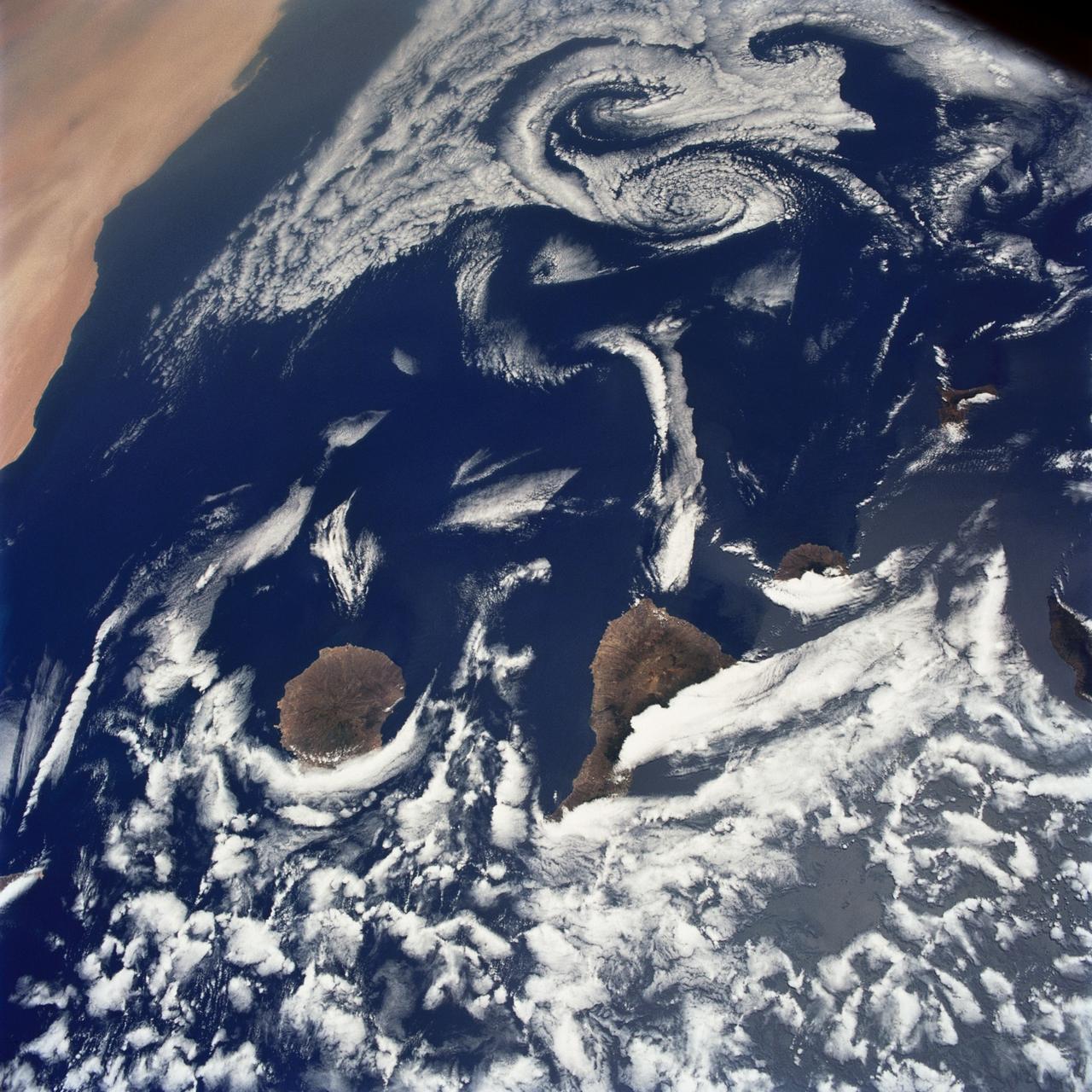
STS040-75-003 (5-14 June 1991) --- This image shows several of the Canary Islands, located in the North Atlantic Ocean just west of Africa. Low level stratus clouds often form here (and along the west coast of continents at these latitudes) are trapped in vertical movement due to an overlying atmospheric temperature inversion. The islands are generating disturbances in the low-level wind flow which is generally from the north-northeast or from top to bottom in the image. These disturbances travel downstream from the islands and manifest themselves as cloud swirls which are called von Karman vortices. The northern extent of a large dust storm moving off the coast of Africa is apparent at the lower right of the image. The dust, extended across the Atlantic Ocean as far west as the Dominican Republic later in the mission.

NOAA's GOES-15 satellite captured the southern California "June Gloom" on June 10, 2013. That's a weather pattern that creates cloudy, overcast skies and cool temperatures. The "June Gloom" of low lying stratus clouds form over the ocean and can be pushed to coastal areas by wind. It usually happens off the west coast of California during the late spring and early summer. As for the "seam" of blue within the "June Gloom," it appears to be actinoform clouds, a seam in the marine stratocumulus aka "June Gloom" of southern California. Actinoform clouds and marine stratus in general are only marginally stable. Sometimes the cloud deck spontaneously dissolves along a line by drizzling out the moisture. This seam is an unusually long curve that is not identified with a coastline or a weather front. Dennis Chesters/Rob Gutro NASA's Goddard Space Flight Center, Greenbelt, Md. REFERENCES <a href="http://en.wikipedia.org/wiki/Actinoform_cloud" rel="nofollow">en.wikipedia.org/wiki/Actinoform_cloud</a> <a href="http://en.wikipedia.org/wiki/June_Gloom" rel="nofollow">en.wikipedia.org/wiki/June_Gloom</a> <b><a href="http://www.nasa.gov/audience/formedia/features/MP_Photo_Guidelines.html" rel="nofollow">NASA image use policy.</a></b> <b><a href="http://www.nasa.gov/centers/goddard/home/index.html" rel="nofollow">NASA Goddard Space Flight Center</a></b> enables NASA’s mission through four scientific endeavors: Earth Science, Heliophysics, Solar System Exploration, and Astrophysics. Goddard plays a leading role in NASA’s accomplishments by contributing compelling scientific knowledge to advance the Agency’s mission. <b>Follow us on <a href="http://twitter.com/NASA_GoddardPix" rel="nofollow">Twitter</a></b> <b>Like us on <a href="http://www.facebook.com/pages/Greenbelt-MD/NASA-Goddard/395013845897?ref=tsd" rel="nofollow">Facebook</a></b> <b>Find us on <a href="http://instagram.com/nasagoddard?vm=grid" rel="nofollow">Instagram</a></b>

ISS017-E-012583 (4 Aug. 2008) --- Cape Farewell, Greenland is featured in this image photographed by an Expedition 17 crewmember on the International Space Station (ISS). This view illustrates the southernmost tip of Greenland, known as Kap Farvel in Danish and Nunap Isua in Inuit. The viewing direction is towards the northeast; the image was taken when the space station was located near its most northerly orbital latitude of 52 degrees, off the northern coast of the Island of Newfoundland approximately 1160 kilometers to the southwest. Greenland is the world's largest island with an area of over 2 million square kilometers; however much of the island is covered by an ice cap that can reach thicknesses of 3 kilometers. The image is highly oblique -- taken from an angle looking outwards from the ISS, rather than straight down towards the Earth -- and this provides a sense of topography along the southern edge of Greenland. The exposed dark grey bedrock along the southwestern coastline has been carved by glaciers into numerous fjords -- steep-sided valleys that drain directly into the ocean; the white cloud cover surrounding the island doubtless contains some sea ice and icebergs calved from glaciers. A band of high-altitude cirrus clouds (light grey) cast shadows on the lower stratus cloud deck in the lower third of the image. The thin blue layer of Earth's atmosphere is visible.
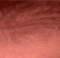
This is the first color image ever taken from the surface of Mars of an overcast sky. Featured are pink stratus clouds coming from the northeast at about 15 miles per hour (6.7 meters/second) at an approximate height of ten miles (16 kilometers) above the surface. The clouds consist of water ice condensed on reddish dust particles suspended in the atmosphere. Clouds on Mars are sometimes localized and can sometimes cover entire regions, but have not yet been observed to cover the entire planet. The image was taken about an hour and forty minutes before sunrise by the Imager for Mars Pathfinder (IMP) on Sol 16 at about ten degrees up from the eastern Martian horizon. Sojourner spent 83 days of a planned seven-day mission exploring the Martian terrain, acquiring images, and taking chemical, atmospheric and other measurements. The final data transmission received from Pathfinder was at 10:23 UTC on September 27, 1997. Although mission managers tried to restore full communications during the following five months, the successful mission was terminated on March 10, 1998. http://photojournal.jpl.nasa.gov/catalog/PIA00796
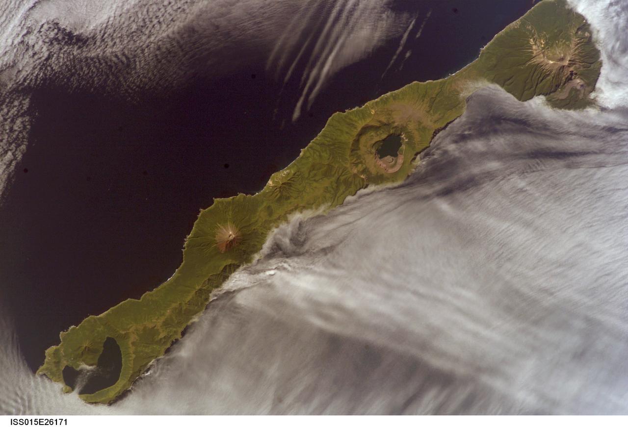
ISS015-E-26171 (1 Sept. 2007) --- Simushir Island, Kuril Archipelago, Russian Far East, is featured in this image photographed by an Expedition 15 crewmember on the International Space Station. Simushir is a deserted, 5-mile-wide volcanic island in the Kuril island chain, half way between northern Japan and the Kamchatka Peninsula of Russia. Four volcanoes - Milne, Prevo, Urataman and Zavaritski - have built cones that are high enough to rise above the altitude of green forest. The remaining remnant of Zavaritski volcano is a caldera -- a structure formed when a volcano collapses into its emptied magma chamber. A small lake fills the innermost of three nested calderas which make up Zavaritski Caldera. The larger caldera of Urataman Volcano is connected to the sea. A defunct Soviet naval base occupies the northern tip of the island next to this caldera. The islands and volcanoes of the Kuril chain are part of the Pacific Rim of Fire, marking the edge of the Pacific tectonic plate. Low stratus clouds approaching from the northwest (from the Sea of Okhotsk--top left) bank up against the northwest side of the island, making complex cloud patterns. A small finger of cloud can be seen entering the northernmost caldera (Urataman) at sea level. When this image was taken, the cloud layer had stopped at the northwest coast of the island, not flowing over even the low points of the island between the volcanoes. The cloud pattern suggests that the air mass flowed up and over the island, descending on the southeast side. This descending motion was enough--under stable atmospheric conditions--to warm up the atmosphere locally so that a cloud-free zone formed on the southeastern, lee side of the island.

ISS038-E-036501 (28 Jan. 2014) --- This wide field-of-view image photographed by an Expedition 38 crew member on the International Space Station shows an east-west swath of the southwestern Indian Ocean. Two remote islands, part of the French Southern and Antarctic Lands, appear in the center of the image. Possession Island (right center) and East Island (center) are both only 18 kilometers long. A smaller island, Ile aux Cochons (Pigs Island), lies 100 kilometers to the west. Each island has set up V-shaped trains of waves, like bow waves, as the air flows over the islands from the west (right to left). The bow-wave patterns are overlaid on the low regional stratus (blanket) cloud that is so common in the southern Indian Ocean at 50 degrees south latitude. This view was taken from more than 400 kilometers above the sea surface and reveals relationships that could not be readily understood by someone standing on one of the islands. For example, larger and higher islands produce larger waves. So the largest are being generated by Possession Island (934 meters above sea level at the highest point), and East Island, versus much smaller waves developed downwind of the tiny Ile de Pingouins (340 meters above sea level high, invisible below the cloud deck). Other patterns also can be detected. Waves in an upper layer can be seen casting shadows onto a lower layer (lower left). In the top half of the image the waves are making thicker and thinner zones in the clouds of the lower layer. Wave trains from Possession Island and Ile aux Cochons are interacting in a cross-hatch pattern (center).
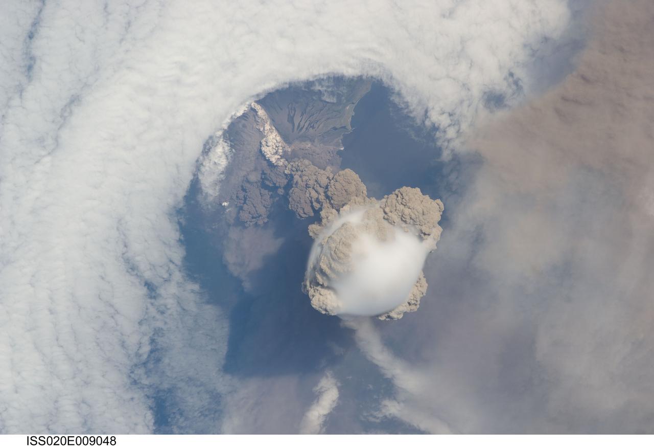
ISS020-E-009048 (12 June 2009) --- Sarychev Peak Volcano eruption, Kuril Islands, is featured in this image photographed by an Expedition 20 crew member on the International Space Station. A fortuitous orbit of the International Space Station allowed the astronauts this striking view of Sarychev volcano (Russia?s Kuril Islands, northeast of Japan) in an early stage of eruption on June 12, 2009. Sarychev Peak is one of the most active volcanoes in the Kuril Island chain and is located on the northwestern end of Matua Island. Prior to June 12, the last explosive eruption had occurred in 1989 with eruptions in 1986, 1976, 1954, and 1946 also producing lava flows. Ash from the June 2009 eruption has been detected 2407 kilometers ESE and 926 kilometers WNW of the volcano, and commercial airline flights are being diverted away from the region to minimize the danger of engine failures from ash intake. This detailed photograph is exciting to volcanologists because it captures several phenomena that occur during the earliest stages of an explosive volcanic eruption. The main column is one of a series of plumes that rose above Matua Island (48.1 degrees north latitude and 153.2 degrees east longitude) on June 12. The plume appears to be a combination of brown ash and white steam. The vigorously rising plume gives the steam a bubble-like appearance; the surrounding atmosphere has been shoved up by the shock wave of the eruption. The smooth white cloud on top may be water condensation that resulted from rapid rising and cooling of the air mass above the ash column, and is probably a transient feature (the eruption plume is starting to punch through). The structure also indicates that little to no shearing winds were present at the time to disrupt the plume. Another series of images, acquired 2-3 days after the start of eruptive activity, illustrate the effect of shearing winds on extent of the ash plumes across the Pacific Ocean. By contrast, a cloud of denser, gray ash ? most probably a pyroclastic flow -- appears to be hugging the ground, descending from the volcano summit. The rising eruption plume casts a shadow to the northwest of the island (bottom center). Brown ash at a lower altitude of the atmosphere spreads out above the ground at upper right. Low-level stratus clouds approach Matua Island from the east, wrapping around the lower slopes of the volcano. Only about 1.5 kilometers of the coastline of Matua Island (upper center) can be seen beneath the clouds and ash.
STS061-101-023 (8 Dec 1993) --- This color photograph is a spectacular, panoramic (southeastern view) shot that features the northern half of the country of Chile and the Andes Mountains of South America. The Atacama Desert, one of the driest regions on earth, is clearly visible along the northern Chilean coast. This desert extends from roughly Arica in the north to the city of Caldera in the south, a distance of six hundred miles. Some parts of this very arid region go for more than twenty years without measurable precipitation. It is an area of dramatic and abrupt elevation changes. For example, from the waters edge there is an escarpment of the coastal plateau that rises like an unbroken wall two or three thousand feet above the Pacific Ocean. From the coastal plateau, there is an even more dramatic increase in elevation -- from two thousand feet above sea level to an average elevation of thirteen thousand feet above sea level in the Bolivian Altiplano. This elevation change occurs within a one hundred to two hundred mile distance from the Pacific Ocean. The north-south trending spine of the Andes Mountains can be seen on this photograph. Several of the volcanic peaks in this mountain chain exceed 20,000 feet above sea level. Interspersed with these volcanic peaks, numerous dry lake beds (salars) can be seen as highly reflective surfaces. The largest of these salars (Salar de Uyuni) is visible at the edge of the Hubble Space Telescope (HST). Offshore, the cold Peruvian current produces low stratus clouds that can be found along this coastline at certain times of the year. This is the same type of meteorological phenomena that is found along the southern California coast and the Skeleton coast of southwestern Africa.