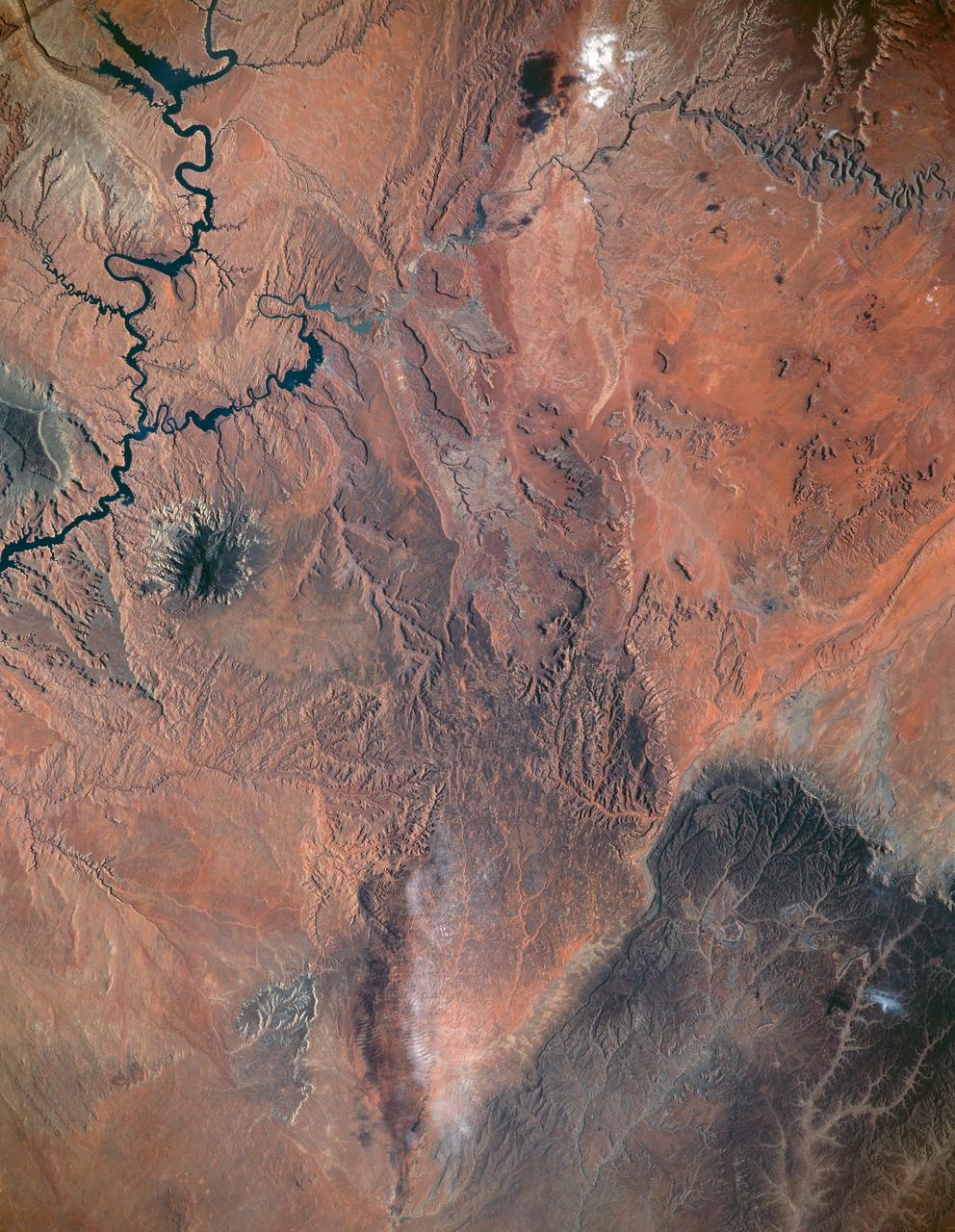
STS040-151-123 (5-14 June 1991) --- This large format view shows parts of northern Arizona and southern Utah. San Juan River, Lake Powell and Monument Valley are visible. Water of Lake Powell can be seen filling the valleys of the Colorado and San Juan Rivers at the top of the image. The darker green areas indicate high, forested country of the lone Navajo Mountain (center left) and Black Mesa (bottom right). Strip mines can be seen south of the rim of Black Mesa. Monument Valley lies between the San Juan River and Black Mesa. Shadows thrown by the individual steep-sided hills make them stand out in the scene.
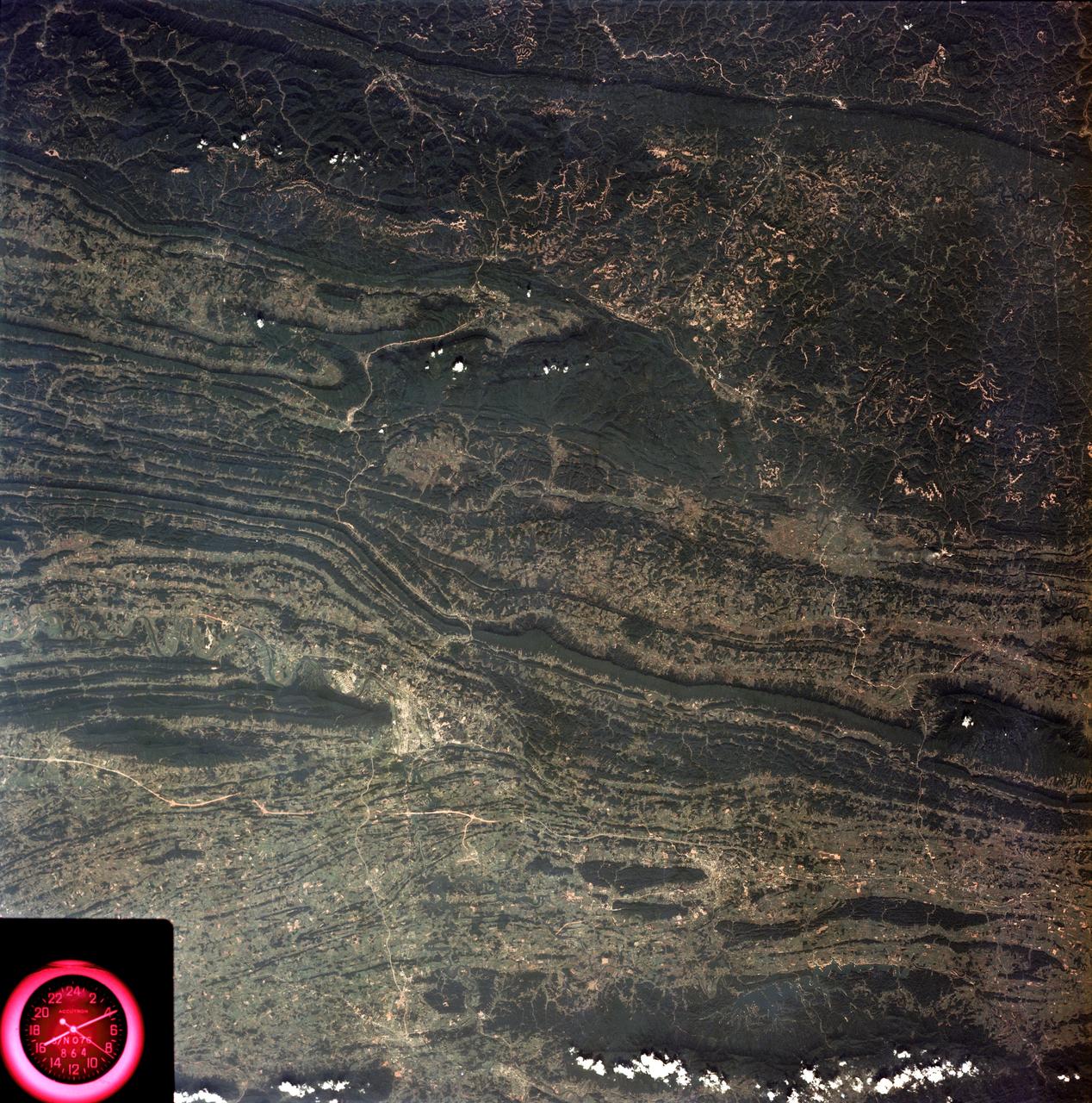
SL3-88-053 (July-September 1973) --- A near vertical view of the Tennessee-Virginia-Kentucky border area is seen in this Skylab 3 Earth Resources Experiments Package S190-B (five-inch Earth terrain camera) photograph taken from the Skylab space station in Earth orbit. The clock is in the most southerly corner of the picture. Interstate 81 under construction extends northeast-southwest across the bottom portion of the photograph. The larger urban area nearest the center of the picture is Kingsport, Tennessee. On the southern side of I-80 and east of Kingsport is the city of Bristol, Tennessee-Virginia. Johnson City, Tennessee is the urban area near the edge of the picture southeast of Kingsport. The Holston River, a tributary of the Tennessee River, meanders through the Kingsport area. The characteristic ridge and valley features in the Cumberland Plateau of Kentucky, Tennessee and Virginia are clearly visible. Forests (dark green) occur on the ridges and clearly outline the folded and faulted rock formations. The valleys (light) were formed in the softer rocks as a result of erosion. Agricultural areas are indicated by the characteristic rectangular patterns. Coal production is an important industry of this area; and it is mined by surface open pit operations. The irregular light areas in the Kentucky-Virginia border area are the strip mines which follow the contour of the land. Reclamation of the strip mine areas is aided through accurate knowledge of the mine and drainage systems. Dr. Ronald Brooks of the Wolf Research and Development Corporation can use this photograph in study of strip mine areas in the east central U.S. Federal agencies participating with NASA on the EREP project are the Departments of Agriculture, Commerce, Interior, the Environmental Protection Agency and the Corps of Engineers. All EREP photography is available to the public through the Department of Interior’s Earth Resources Observations Systems Data Center, Sioux Falls, South Dakota, 57198. Photo credit: NASA
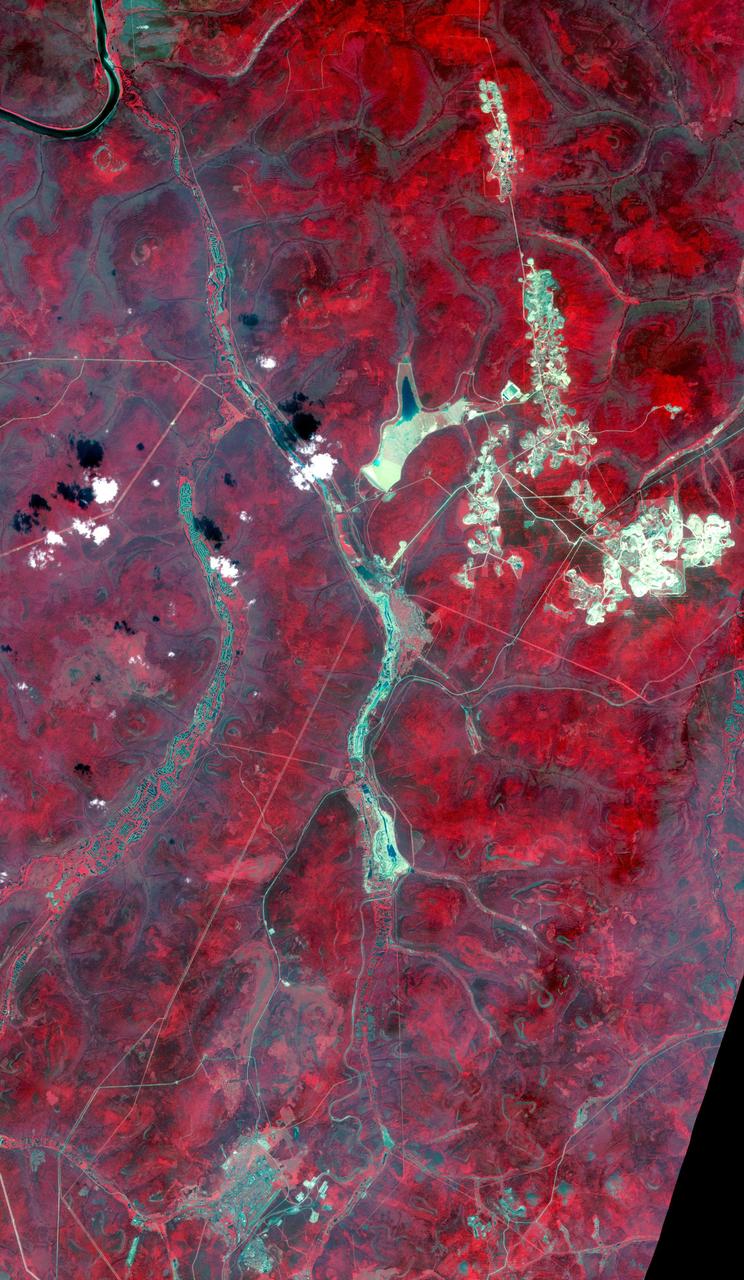
Aldan is the administrative center of the Aldansky District in Siberia, Russia. It was founded in 1923 after discovery of rich gold and uranium deposits. The city can be seen at the bottom of the image. To the north, squiggly tracks in the rivers are the spoilage piles from dredging operations. In the upper right are numerous tailings piles from conventional strip and underground mining operations. The image was acquired July 31, 2019, covers an area of 30.8 by 53 km, and is located near 58.6 degrees north, 125.4 degrees east. https://photojournal.jpl.nasa.gov/catalog/PIA24126
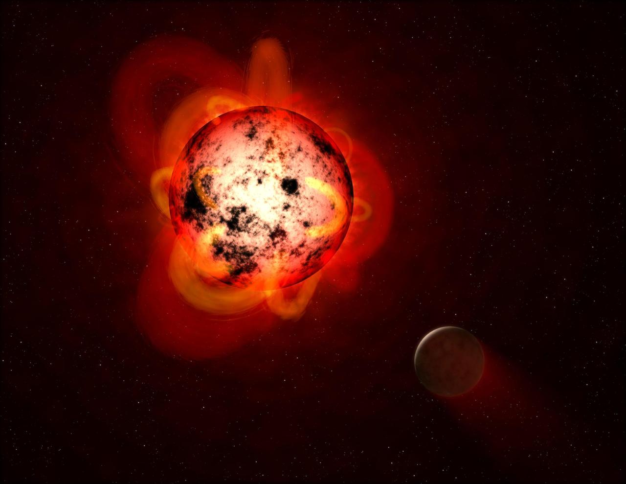
This illustration shows a red dwarf star orbited by a hypothetical exoplanet. Red dwarfs tend to be magnetically active, displaying gigantic arcing prominences and a wealth of dark sunspots. Red dwarfs also erupt with intense flares that could strip a nearby planet's atmosphere over time, or make the surface inhospitable to life as we know it. By mining data from the Galaxy Evolution Explorer (GALEX) spacecraft, a team of astronomers identified dozens of flares at a range of durations and strengths. The team measured events with less total energy than many previously detected flares from red dwarfs. This is important because, although individually less energetic and therefore less hostile to life, smaller flares might be much more frequent and add up over time to produce a cumulative effect on an orbiting planet. https://photojournal.jpl.nasa.gov/catalog/PIA21473
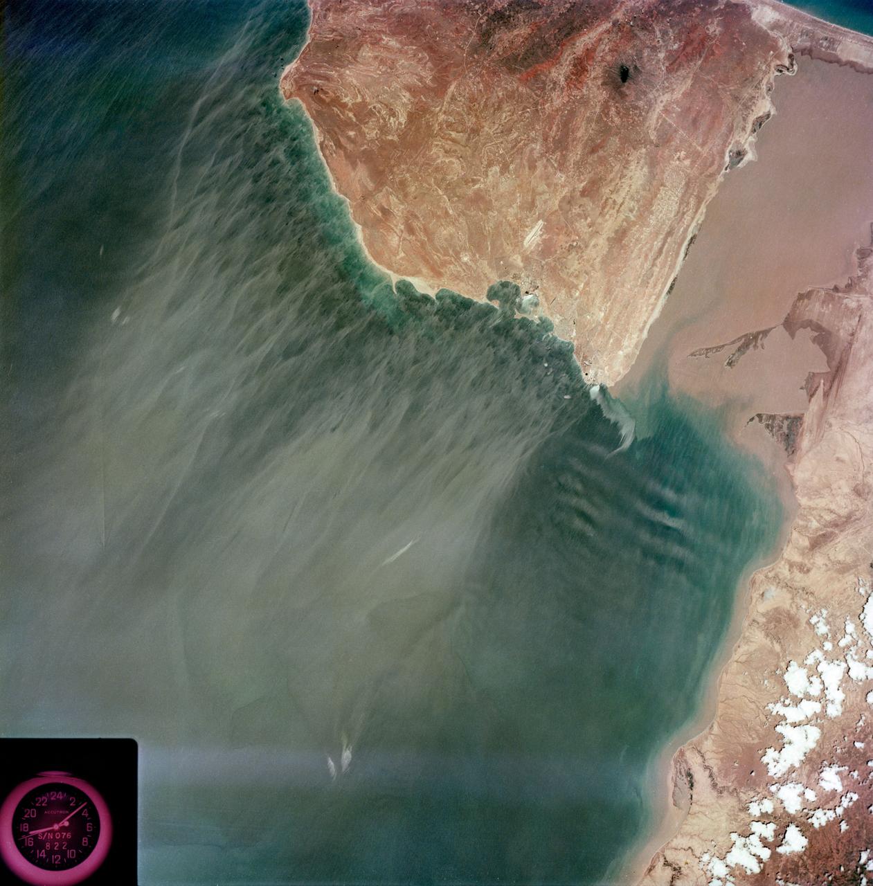
S73-35079 (July-September 1973) --- A near vertical view of the Caribbean coast of Venezuela is seen in this Skylab 3 Earth Resources Experiment Package S190-B (five-inch Earth terrain camera) photograph taken from the Skylab space station in Earth orbit. The large body of water is the Golfo de Venezuela; and the major land mass is the Peninsula de Paraguana. The view is looking northward from the mouth of the Golfete de Coro and Punta Cardon to Punta Macolla. The peninsula is connected to the Venezuelan mainland by the narrow strip of land in the most easterly corner of the picture. The dry, arid climate on the peninsula is indicated by sparse vegetation and the abundance of sand dunes. The highest point is about 2,700 feet above the sea and is the conspicuous black spot. Old raised shoreline features appear as streaks parallel to the Golfete de Coro. Sand dunes and stream erosion have modified these features. Water of the Golfete de Coro is red from the high sediment content. The streaks in the water off the peninsula is apparently an effect of wind which is blowing sand and water offshore. The EREP investigator Dr. Jose Antonio Galavis, of the Ministerio de Mines e Hidrocarburos, will use this information to map geology and coastal sedimentation in the Peninsula de Paraguana. Federal agencies participating with NASA on the EREP projects are the Departments of Agriculture, Commerce, Interior, the Environmental Protection Agency and the Corps of Engineers. All EREP photography is available to the public through the Department of Interior?s Earth Resources Observations Systems Data Center, Sioux Falls, South Dakota, 57198. (Alternate number SL3-83-237) Photo credit: NASA