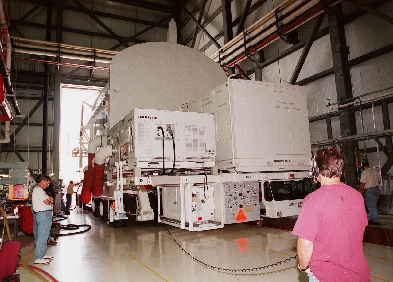
KENNEDY SPACE CENTER, FLA. -- A payload transporter, carrying a payload canister with the Shuttle Radar Topography Mission (SRTM) inside, pulls into Orbiter Processing Facility (OPF) bay 2. The SRTM, the primary payload on STS-99, will soon be installed into the payload bay of the orbiter Endeavour already undergoing processing in bay 2. The SRTM consists of a specially modified radar system that will gather data for the most accurate and complete topographic map of the Earth's surface that has ever been assembled. SRTM will make use of radar interferometry, wherein two radar images are taken from slightly different locations. Differences between these images allow for the calculation of surface elevation. The SRTM hardware includes one radar antenna in the Shuttle payload bay and a second radar antenna attached to the end of a mast extended 60 meters (195 feet) from the shuttle. STS-99 is scheduled to launch Sept. 16 at 8:47 a.m. from Launch Pad 39A
KENNEDY SPACE CENTER, FLA. -- A crane is lowered over the payload canister with the Shuttle Radar Topography Mission (SRTM) inside in Orbiter Processing Facility (OPF) bay 2. The primary payload on STS-99, the SRTM will soon be lifted out of the canister and installed into the payload bay of the orbiter Endeavour. The SRTM consists of a specially modified radar system that will gather data for the most accurate and complete topographic map of the Earth's surface that has ever been assembled. SRTM will make use of radar interferometry, wherein two radar images are taken from slightly different locations. Differences between these images allow for the calculation of surface elevation. The SRTM hardware includes one radar antenna in the Shuttle payload bay and a second radar antenna attached to the end of a mast extended 60 meters (195 feet) from the shuttle. STS-99 is scheduled to launch Sept. 16 at 8:47 a.m. from Launch Pad 39A
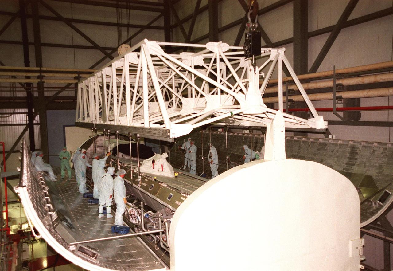
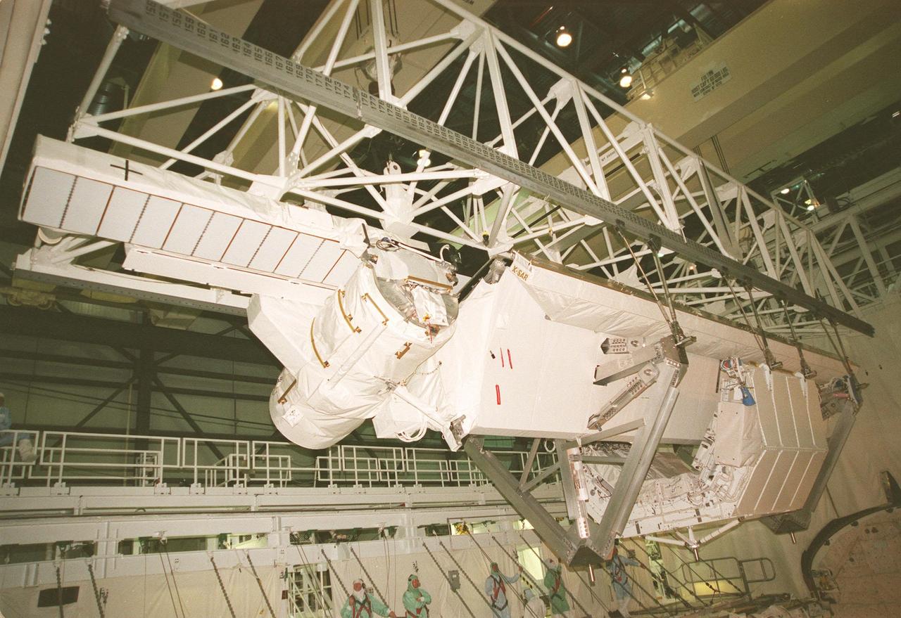
KENNEDY SPACE CENTER, FLA. -- A crane lifts the Shuttle Radar Topography Mission (SRTM), the primary payload on STS-99, from a payload canister used to transport it to Orbiter Processing Facility (OPF) bay 2 to the payload bay of the orbiter Endeavour. The SRTM consists of a specially modified radar system that will gather data for the most accurate and complete topographic map of the Earth's surface that has ever been assembled. SRTM will make use of radar interferometry, wherein two radar images are taken from slightly different locations. Differences between these images allow for the calculation of surface elevation. The SRTM hardware includes one radar antenna in the Shuttle payload bay and a second radar antenna attached to the end of a mast extended 60 meters (195 feet) from the shuttle. STS-99 is scheduled to launch Sept. 16 at 8:47 a.m. from Launch Pad 39A
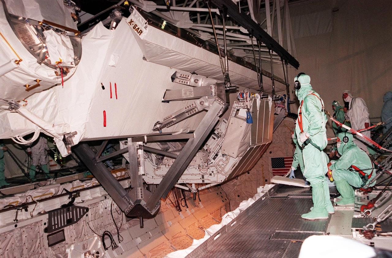
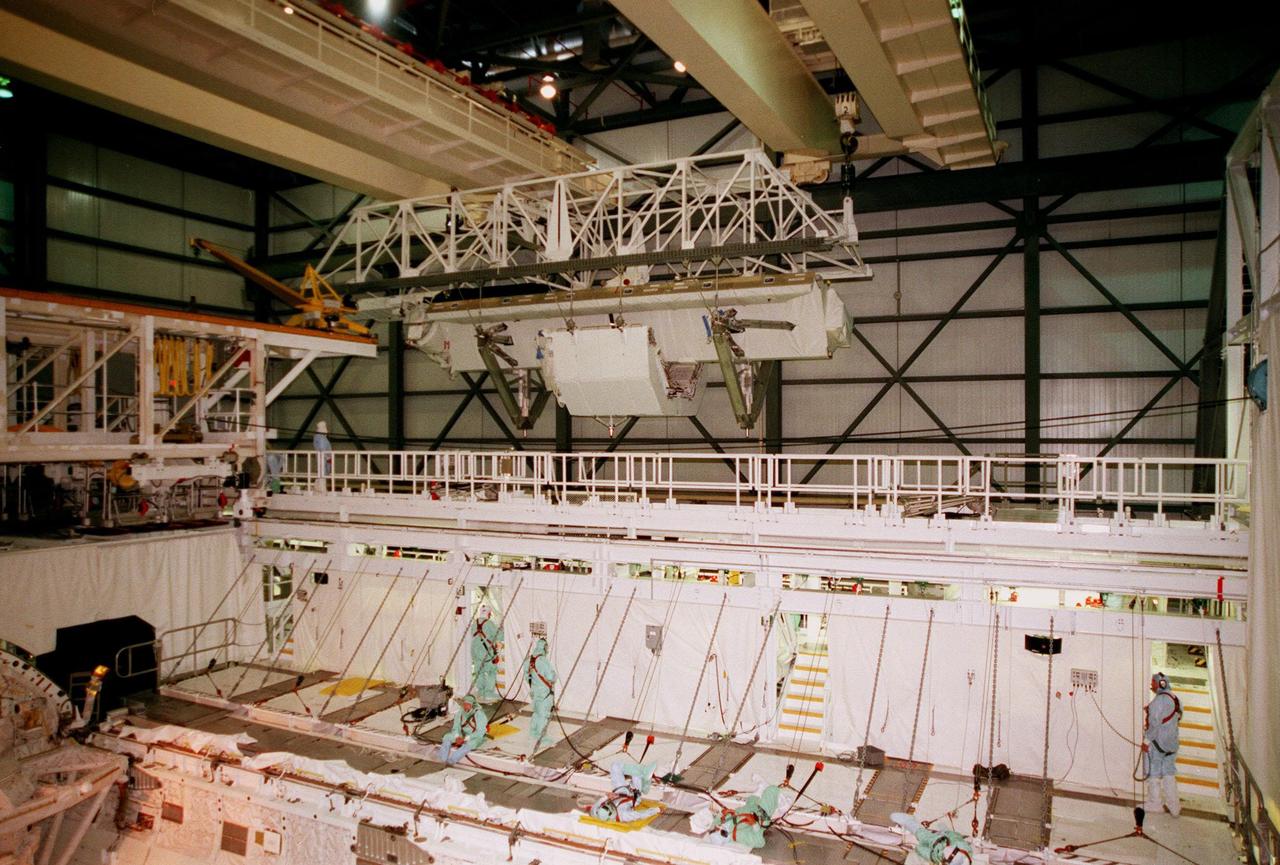
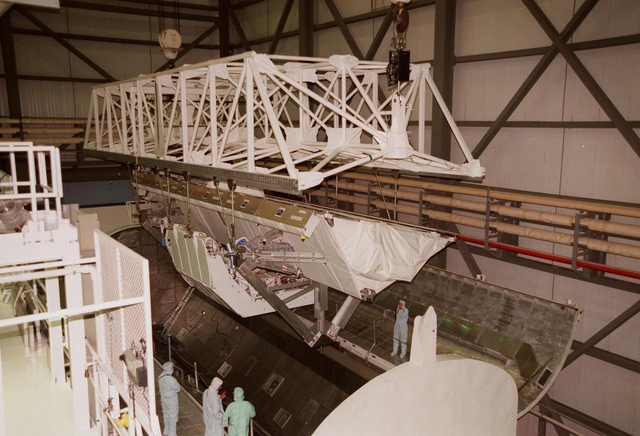
KENNEDY SPACE CENTER, FLA. -- A crane lowers the Shuttle Radar Topography Mission (SRTM), the primary payload on STS-99, into the payload bay of the orbiter Endeavour in Orbiter Processing Facility bay 2. The SRTM consists of a specially modified radar system that will gather data for the most accurate and complete topographic map of the Earth's surface that has ever been assembled. SRTM will make use of radar interferometry, wherein two radar images are taken from slightly different locations. Differences between these images allow for the calculation of surface elevation. The SRTM hardware includes one radar antenna in the Shuttle payload bay and a second radar antenna attached to the end of a mast extended 60 meters (195 feet) from the shuttle. STS-99 is scheduled to launch Sept. 16 at 8:47 a.m. from Launch Pad 39A
KENNEDY SPACE CENTER, FLA. -- A crane lifts the Shuttle Radar Topography Mission (SRTM), the primary payload on STS-99, from a payload canister used to transport it to Orbiter Processing Facility (OPF) bay 2. The SRTM will soon be installed into the payload bay of the orbiter Endeavour. The SRTM consists of a specially modified radar system that will gather data for the most accurate and complete topographic map of the Earth's surface that has ever been assembled. SRTM will make use of radar interferometry, wherein two radar images are taken from slightly different locations. Differences between these images allow for the calculation of surface elevation. The SRTM hardware includes one radar antenna in the Shuttle payload bay and a second radar antenna attached to the end of a mast extended 60 meters (195 feet) from the shuttle. STS-99 is scheduled to launch Sept. 16 at 8:47 a.m. from Launch Pad 39A
KENNEDY SPACE CENTER, FLA. -- A crane lowers the Shuttle Radar Topography Mission (SRTM), the primary payload on STS-99, into the payload bay of the orbiter Endeavour in Orbiter Processing Facility (OPF) bay 2. The SRTM consists of a specially modified radar system that will gather data for the most accurate and complete topographic map of the Earth's surface that has ever been assembled. SRTM will make use of radar interferometry, wherein two radar images are taken from slightly different locations. Differences between these images allow for the calculation of surface elevation. The SRTM hardware includes one radar antenna in the Shuttle payload bay and a second radar antenna attached to the end of a mast extended 60 meters (195 feet) from the shuttle. STS-99 is scheduled to launch Sept. 16 at 8:47 a.m. from Launch Pad 39A
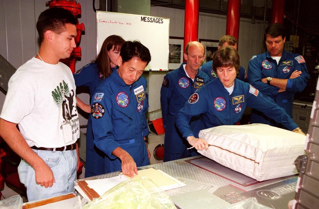
In the Orbiter Processing Facility (OPF) Bay 2, under the watchful eyes of a KSC worker (far left) the STS-99 crew look over equipment as part of a Crew Equipment Interface Test (CEIT). From left (second from right) are Mission Specialists Janet Lynn Kavandi (Ph.D.), Mamoru Mohri, Gerhard P.J. Thiele, and Janice Voss (Ph.D.); behind Voss are Pilot Dominic L. Pudwill Gorie and Commander Kevin R. Kregel. Mohri is with the National Space Development Agency (NASDA) of Japan, and Thiele is with the European Space Agency. The CEIT provides an opportunity for crew members to check equipment and facilities that will be aboard the orbiter during their mission. The STS-99 mission is the Shuttle Radar Topography Mission (SRTM), a specially modified radar system that will gather data for the most accurate and complete topographic map of the Earth's surface that has ever been assembled. SRTM will make use of radar interferometry, wherein two radar images are taken from slightly different locations. Differences between these images allow for the calculation of surface elevation, or change. The SRTM hardware will consist of one radar antenna in the shuttle payload bay and a second radar antenna attached to the end of a mast extended 60 meters (195 feet) out from the shuttle. STS-99 is scheduled to launch Sept. 16 at 8:47 a.m. from Launch Pad 39A
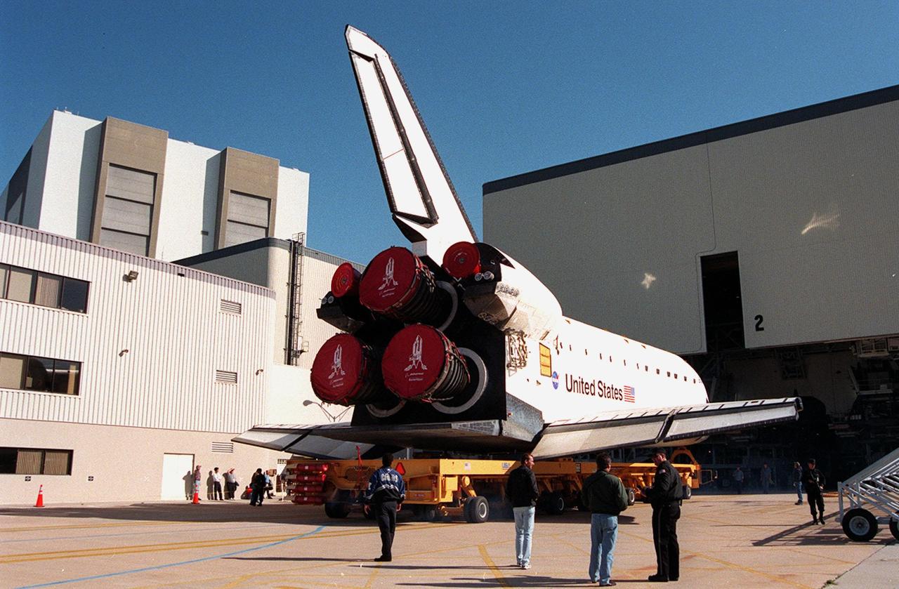
KENNEDY SPACE CENTER, FLA. -- Orbiter Endeavour rolls out of the Orbiter Processing Facility bay 2 for transfer to the Vehicle Assembly Building. There it will be mated to the external tank and solid rocket boosters in high bay 1. Space Shuttle Endeavour is targeted for launch on mission STS-99 Jan. 13, 2000 at 1:11 p.m. EST. STS-99 is the Shuttle Radar Topography Mission, an international project spearheaded by the National Imagery and Mapping Agency and NASA, with participation of the German Aerospace Center DLR. The SRTM consists of a specially modified radar system that will gather data for the most accurate and complete topographic map of the Earth's surface that has ever been assembled. SRTM will make use of radar interferometry, wherein two radar images are taken from slightly different locations. Differences between these images allow for the calculation of surface elevation, or change. The SRTM hardware will consist of one radar antenna in the shuttle payload bay and a second radar antenna attached to the end of a mast extended 60 meters (195 feet) out from the shuttle
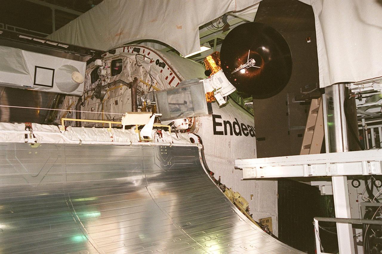
KENNEDY SPACE CENTER, FLA. -- Orbiter Endeavour waits in the Orbiter Processing Facility bay 2 for the closing of its payload bay doors. The Ku-band antenna (upper right) is still in the open position, outside the payload bay. Endeavour is expected to roll over to the Vehicle Assembly Building in three days for mating to the external tank and solid rocket boosters in high bay 1. Space Shuttle Endeavour is targeted for launch on mission STS-99 Jan. 13, 2000 at 1:11 p.m. EST. STS-99 is the Shuttle Radar Topography Mission, an international project spearheaded by the National Imagery and Mapping Agency and NASA, with participation of the German Aerospace Center DLR. The SRTM consists of a specially modified radar system that will gather data for the most accurate and complete topographic map of the Earth's surface that has ever been assembled. SRTM will make use of radar interferometry, wherein two radar images are taken from slightly different locations. Differences between these images allow for the calculation of surface elevation, or change. The SRTM hardware will consist of one radar antenna in the shuttle payload bay and a second radar antenna attached to the end of a mast extended 60 meters (195 feet) out from the shuttle
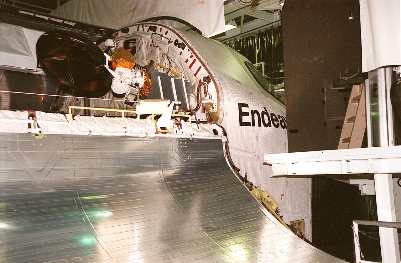
KENNEDY SPACE CENTER, FLA. -- Orbiter Endeavour waits in the Orbiter Processing Facility bay 2 for the closing of its payload bay doors. The Ku-band antenna (upper right) is now in its closed position inside the payload bay. Endeavour is expected to roll over to the Vehicle Assembly Building in three days for mating to the external tank and solid rocket boosters in high bay 1. Space Shuttle Endeavour is targeted for launch on mission STS-99 Jan. 13, 2000 at 1:11 p.m. EST. STS-99 is the Shuttle Radar Topography Mission, an international project spearheaded by the National Imagery and Mapping Agency and NASA, with participation of the German Aerospace Center DLR. The SRTM consists of a specially modified radar system that will gather data for the most accurate and complete topographic map of the Earth's surface that has ever been assembled. SRTM will make use of radar interferometry, wherein two radar images are taken from slightly different locations. Differences between these images allow for the calculation of surface elevation, or change. The SRTM hardware will consist of one radar antenna in the shuttle payload bay and a second radar antenna attached to the end of a mast extended 60 meters (195 feet) out from the shuttle
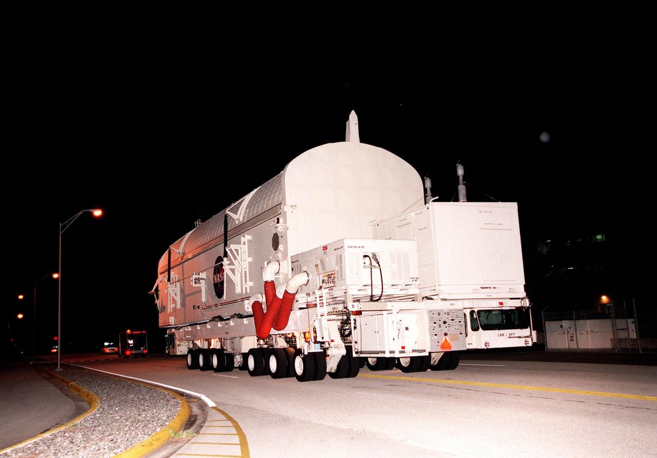
KENNEDY SPACE CENTER, FLA. -- A payload canister containing the Shuttle Radar Topography Mission (SRTM), riding atop a payload transporter, is moved from the Space Station Processing Facility to Orbiter Processing Facility (OPF) bay 2. Once there, the SRTM, the primary payload on STS-99, will be installed into the payload bay of the orbiter Endeavour. The SRTM consists of a specially modified radar system that will gather data for the most accurate and complete topographic map of the Earth's surface that has ever been assembled. SRTM will make use of radar interferometry, wherein two radar images are taken from slightly different locations. Differences between these images allow for the calculation of surface elevation. The SRTM hardware includes one radar antenna in the Shuttle payload bay and a second radar antenna attached to the end of a mast extended 60 meters (195 feet) from the shuttle. STS-99 is scheduled to launch Sept. 16 at 8:47 a.m. from Launch Pad 39A
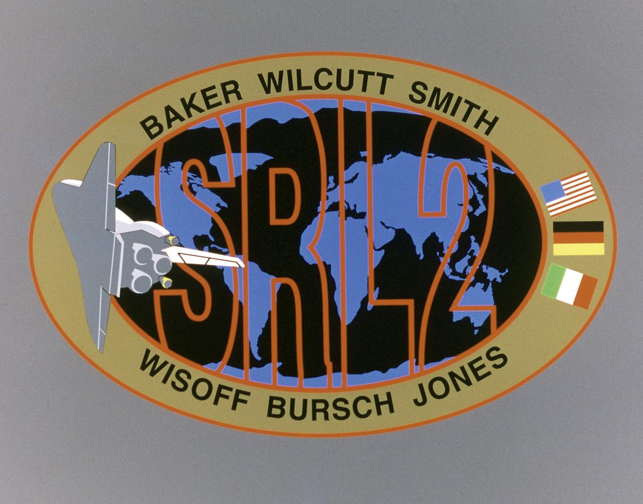
This STS-68 patch was designed by artist Sean Collins. Exploration of Earth from space is the focus of the design of the insignia, the second flight of the Space Radar Laboratory (SRL-2). SRL-2 was part of NASA's Mission to Planet Earth (MTPE) project. The world's land masses and oceans dominate the center field, with the Space Shuttle Endeavour circling the globe. The SRL-2 letters span the width and breadth of planet Earth, symbolizing worldwide coverage of the two prime experiments of STS-68: The Shuttle Imaging Radar-C and X-Band Synthetic Aperture Radar (SIR-C/X-SAR) instruments; and the Measurement of Air Pollution from Satellites (MAPS) sensor. The red, blue, and black colors of the insignia represent the three operating wavelengths of SIR-C/X-SAR, and the gold band surrounding the globe symbolizes the atmospheric envelope examined by MAPS. The flags of international partners Germany and Italy are shown opposite Endeavour. The relationship of the Orbiter to Earth highlights the usefulness of human space flights in understanding Earth's environment, and the monitoring of its changing surface and atmosphere. In the words of the crew members, the soaring Orbiter also typifies the excellence of the NASA team in exploring our own world, using the tools which the Space Program developed to explore the other planets in the solar system.
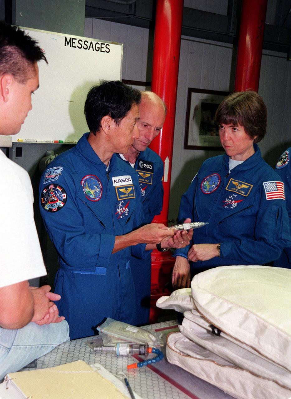
Under the watchful eyes of a KSC worker (far left), members of the STS-99 crew check out equipment in the Orbiter Processing Facility (OPF) Bay 2. From left are Mission Specialists Mamoru Mohri, Gerhard P.J. Thiele, and Janice Voss (Ph.D.). Mohri represents the National Space Development Agency (NASDA) of Japan, and Thiele the European Space Agency. Other crew members (not shown) are Commander Kevin R. Kregel, Pilot Dominic L. Pudwill Gorie, and Mission Specialist Janet Lynn Kavandi (Ph.D.). The crew are at KSC to take part in a Crew Equipment Interface Test (CEIT), which provides an opportunity for crew members to check equipment and facilities that will be aboard the orbiter during their mission. The STS-99 mission is the Shuttle Radar Topography Mission (SRTM), a specially modified radar system that will gather data for the most accurate and complete topographic map of the Earth's surface that has ever been assembled. SRTM will make use of radar interferometry, wherein two radar images are taken from slightly different locations. Differences between these images allow for the calculation of surface elevation, or change. The SRTM hardware will consist of one radar antenna in the shuttle payload bay and a second radar antenna attached to the end of a mast extended 60 meters (195 feet) out from the shuttle. STS-99 is scheduled to launch Sept. 16 at 8:47 a.m. from Launch Pad 39A
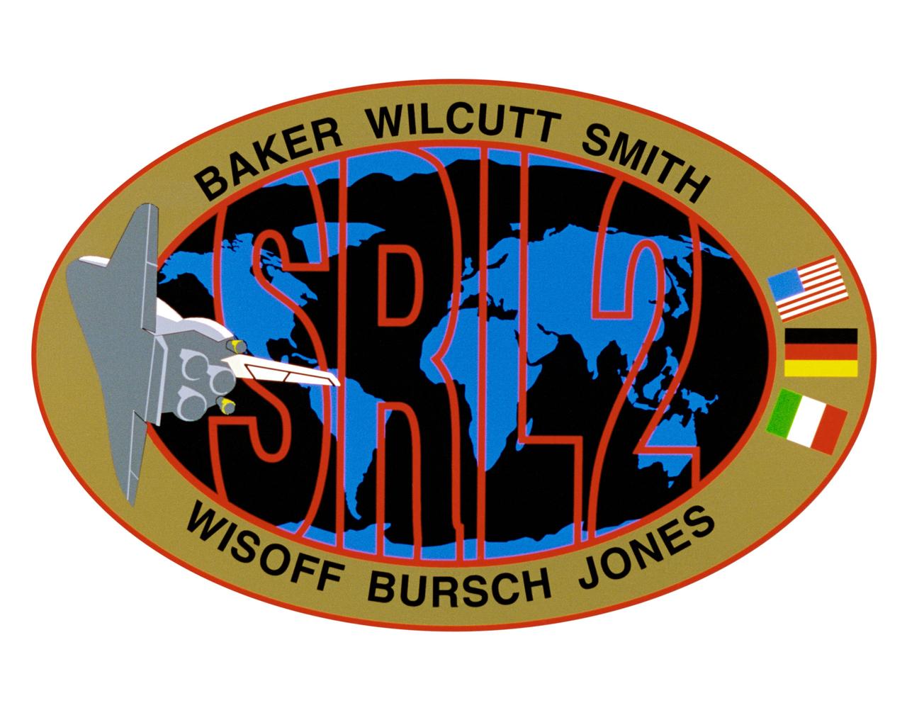
STS068-S-001 (March 1994) --- Exploration of Earth from space is the focus of the design of the STS-68 insignia, the second flight of the Space Radar Laboratory (SRL-2). SRL-2 is part of NASA's Mission to Planet Earth (MTPE) *project. The world's land masses and oceans dominate the center field, with the space shuttle Endeavour circling the globe. The SRL-2 letters span the width and breadth of planet Earth, symbolizing worldwide coverage of the two prime experiments of STS-68 - The Shuttle Imaging Radar-C and X-Band Synthetic Aperture Radar (SIR-C/X-SAR) instruments, and the Measurement of Air Pollution from Satellites (MAPS) sensor. The red, blue and black colors of the insignia represent the three operating wavelengths of SIR-C/X-SAR, and the gold band surrounding the globe symbolizes the atmospheric envelope examined by MAPS. The flags of international partners Germany and Italy are shown opposite Endeavour. The relationship of the orbiter to Earth highlights the usefulness of human spaceflights in understanding Earth's environment, and the monitoring its changing surface and atmosphere. In the words of the crew members, "the soaring orbiter also typifies the excellence of the NASA team in exploring our own world, using the tools which the Space Program developed to explore the other planets in the solar system". This STS-68 patch was designed by artist Sean Collins. The NASA insignia design for space shuttle flights is reserved for use by the astronauts and for other official use as the NASA Administrator may authorize. Public availability has been approved only in the forms of illustrations by the various news media. When and if there is any change in this policy, which is not anticipated, the change will be publicly announced. Photo credit: NASA
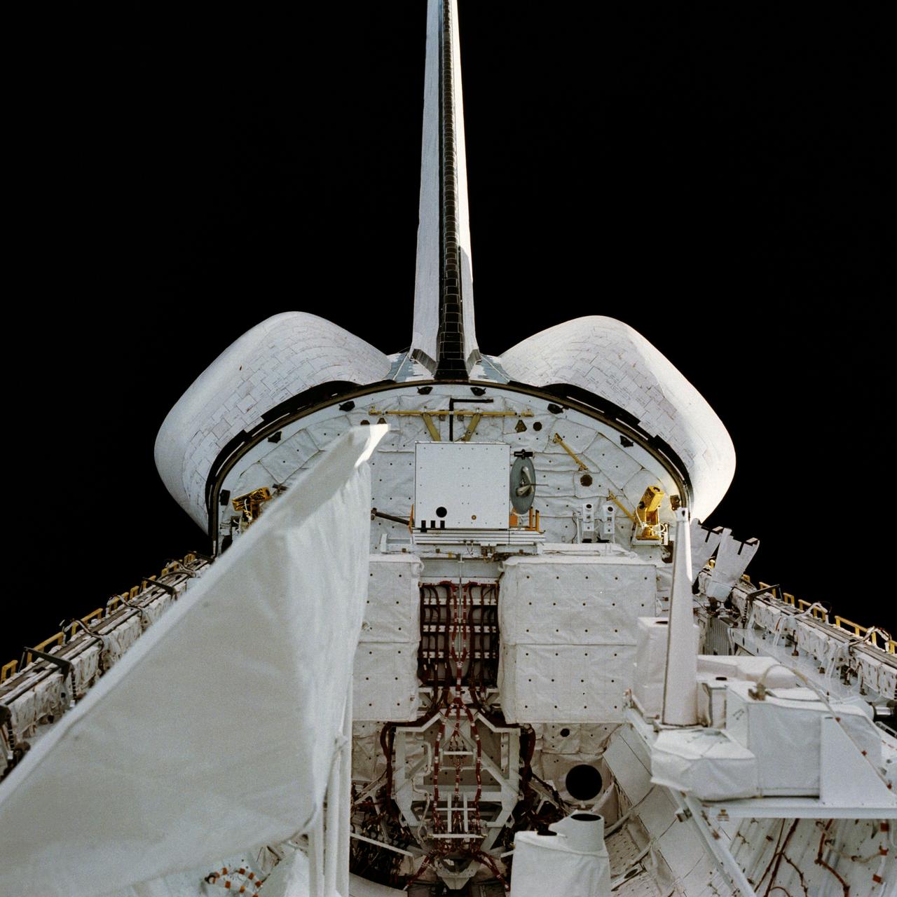
STS002-13-208 (12-14 Nov. 1981) --- This clear view of the aft section of the Earth-orbiting space shuttle Columbia's cargo bay and some of its cargo was photographed through the flight deck's aft windows. Visible in the center of the photo are the twin orbital maneuvering system (OMS) pods. The vertical stabilizer or tail splits the top part of the image in half. The Induced Environment Contamination Monitor (IECM) Location experiment is located in the back center of the cargo bay, near the top. There is a grapple fixture attached to the side of the IECM. Various components of the Office of Space Terrestrial Applications (OSTA-1) payload are seen near the aft section of the cargo bay, such as the Feature Identification and Location Experiment (FILE) (the long cone shaped object on the right back), the Shuttle Multispectral Infrared Radiometer (SMIRR) (on pallet base) and the SIR-A recorder in the right foreground. In the left foreground the Shuttle Imaging Radar-A (SIR-A) antenna can be seen. Photo credit: NASA

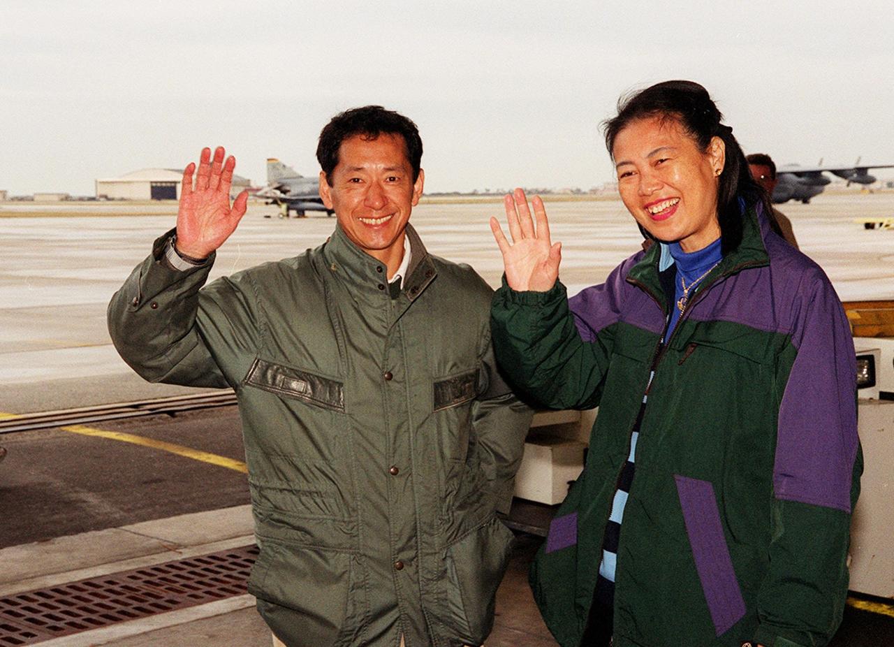
STS-99 Mission Specialist Mamoru Mohri of Japan and his wife, Akiko, wave before their departure from Patrick Air Force Base and return to Houston. With the postponement of the launch of STS-99 on Jan. 31, the crew have an opportunity for more training and time with their families. During the launch countdown, Endeavour's enhanced master events controller (E-MEC) No. 2 failed a standard preflight test. Launch was postponed and Shuttle managers decided to replace the E-MEC located in the orbiter's aft compartment. Launch controllers will be in a position to begin the STS-99 countdown the morning of Feb. 6 and ready to support a launch midto late next week pending availability of the Eastern Range. Known as the Shuttle Radar Topography Mission, it will chart a new course to produce unrivaled 3-D images of the Earth's surface, using two antennae and a 200-foot-long section of space station-derived mast protruding from the payload bay. The result could be close to 1 trillion measurements of the Earth's topography. Besides contributing to the production of better maps, these measurements could lead to improved water drainage modeling, more realistic flight simulators, better locations for cell phone towers, and enhanced navigation safety
STS-99 Mission Specialist Mamoru Mohri of Japan and his wife, Akiko, wave before their departure from Patrick Air Force Base and return to Houston. With the postponement of the launch of STS-99 on Jan. 31, the crew have an opportunity for more training and time with their families. During the launch countdown, Endeavour's enhanced master events controller (E-MEC) No. 2 failed a standard preflight test. Launch was postponed and Shuttle managers decided to replace the E-MEC located in the orbiter's aft compartment. Launch controllers will be in a position to begin the STS-99 countdown the morning of Feb. 6 and ready to support a launch midto late next week pending availability of the Eastern Range. Known as the Shuttle Radar Topography Mission, it will chart a new course to produce unrivaled 3-D images of the Earth's surface, using two antennae and a 200-foot-long section of space station-derived mast protruding from the payload bay. The result could be close to 1 trillion measurements of the Earth's topography. Besides contributing to the production of better maps, these measurements could lead to improved water drainage modeling, more realistic flight simulators, better locations for cell phone towers, and enhanced navigation safety

STS-99 Mission Specialist Mamoru Mohri of Japan waves before his departure from Patrick Air Force Base and return to Houston. With the postponement of the launch of STS-99 on Jan. 31, the crew have an opportunity for more training and time with their families. During the launch countdown, Endeavour's enhanced master events controller (E-MEC) No. 2 failed a standard preflight test. Launch was postponed and Shuttle managers decided to replace the E-MEC located in the orbiter's aft compartment. Launch controllers will be in a position to begin the STS-99 countdown the morning of Feb. 6 and ready to support a launch midto late next week pending availability of the Eastern Range. Known as the Shuttle Radar Topography Mission, it will chart a new course to produce unrivaled 3-D images of the Earth's surface, using two antennae and a 200-foot-long section of space station-derived mast protruding from the payload bay. The result could be close to 1 trillion measurements of the Earth's topography. Besides contributing to the production of better maps, these measurements could lead to improved water drainage modeling, more realistic flight simulators, better locations for cell phone towers, and enhanced navigation safety

STS-99 Mission Specialist Mamoru Mohri of Japan waves before his departure from Patrick Air Force Base and return to Houston. With the postponement of the launch of STS-99 on Jan. 31, the crew have an opportunity for more training and time with their families. During the launch countdown, Endeavour's enhanced master events controller (E-MEC) No. 2 failed a standard preflight test. Launch was postponed and Shuttle managers decided to replace the E-MEC located in the orbiter's aft compartment. Launch controllers will be in a position to begin the STS-99 countdown the morning of Feb. 6 and ready to support a launch midto late next week pending availability of the Eastern Range. Known as the Shuttle Radar Topography Mission, it will chart a new course to produce unrivaled 3-D images of the Earth's surface, using two antennae and a 200-foot-long section of space station-derived mast protruding from the payload bay. The result could be close to 1 trillion measurements of the Earth's topography. Besides contributing to the production of better maps, these measurements could lead to improved water drainage modeling, more realistic flight simulators, better locations for cell phone towers, and enhanced navigation safety
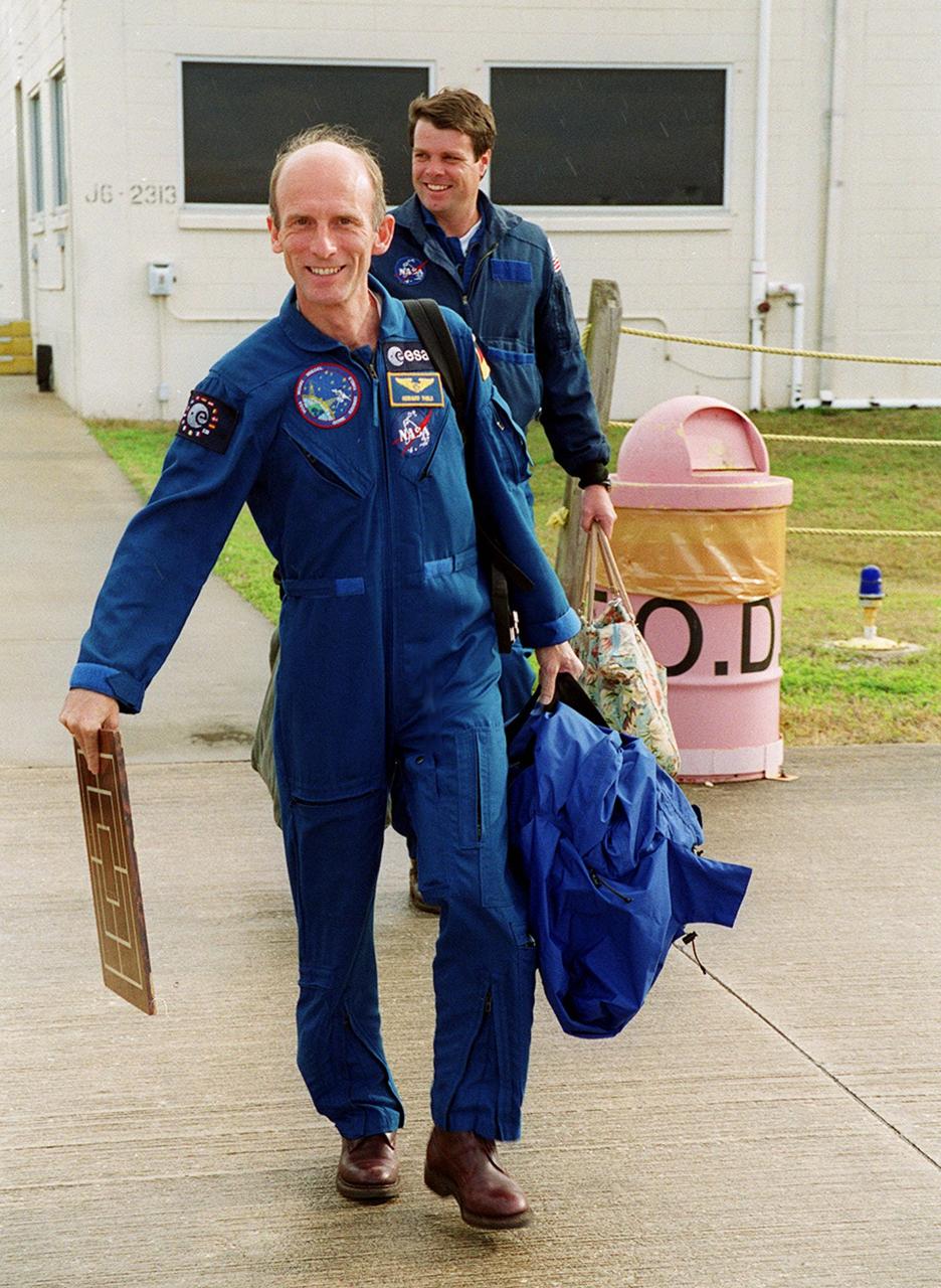
STS-99 Mission Specialist Gerhard Thiele (foreground) and Commander Kevin Kregel make their way to the runway at the Shuttle Landing Facility for a return flight to Houston. During the Jan. 31 launch countdown, Endeavour's enhanced master events controller (E-MEC) No. 2 failed a standard preflight test. Launch was postponed and Shuttle managers decided to replace the E-MEC located in the orbiter's aft compartment. Launch controllers will be in a position to begin the STS-99 countdown the morning of Feb. 6 and ready to support a launch midto late next week pending availability of the Eastern Range. The postponed launch gives the crew an opportunity for more training and time with their families. Known as the Shuttle Radar Topography Mission, it will chart a new course to produce unrivaled 3-D images of the Earth's surface, using two antennae and a 200-foot-long section of space station-derived mast protruding from the payload bay. The result could be close to 1 trillion measurements of the Earth's topography. Besides contributing to the production of better maps, these measurements could lead to improved water drainage modeling, more realistic flight simulators, better locations for cell phone towers, and enhanced navigation safety

On the runway at the Shuttle Landing Facility, STS-99 crew members Pilot Dominic Gorie, Mission Specialist Janice Voss, Commander Kevin Kregel and Mission Specialist Gerhard Thiele discuss departure plans to Houston. Kregel and Gorie will be piloting T-38 jets with Voss and Thiele as passengers. During the Jan. 31 launch countdown, Endeavour's enhanced master events controller (E-MEC) No. 2 failed a standard preflight test. Launch was postponed and Shuttle managers decided to replace the E-MEC located in the orbiter's aft compartment. Launch controllers will be in a position to begin the STS-99 countdown the morning of Feb. 6 and ready to support a launch midto latenext week pending availability of the Eastern Range. The postponed launch gives the crew an opportunity for more training and time with their families. Known as the Shuttle Radar Topography Mission, it will chart a new course to produce unrivaled 3-D images of the Earth's surface, using two antennae and a 200-foot-long section of space station-derived mast protruding from the payload bay. The result could be close to 1 trillion measurements of the Earth's topography. Besides contributing to the production of better maps, these measurements could lead to improved water drainage modeling, more realistic flight simulators, better locations for cell phone towers, and enhanced navigation safety

STS-99 Mission Specialist Gerhard Thiele (foreground) and Commander Kevin Kregel make their way to the runway at the Shuttle Landing Facility for a return flight to Houston. During the Jan. 31 launch countdown, Endeavour's enhanced master events controller (E-MEC) No. 2 failed a standard preflight test. Launch was postponed and Shuttle managers decided to replace the E-MEC located in the orbiter's aft compartment. Launch controllers will be in a position to begin the STS-99 countdown the morning of Feb. 6 and ready to support a launch midto late next week pending availability of the Eastern Range. The postponed launch gives the crew an opportunity for more training and time with their families. Known as the Shuttle Radar Topography Mission, it will chart a new course to produce unrivaled 3-D images of the Earth's surface, using two antennae and a 200-foot-long section of space station-derived mast protruding from the payload bay. The result could be close to 1 trillion measurements of the Earth's topography. Besides contributing to the production of better maps, these measurements could lead to improved water drainage modeling, more realistic flight simulators, better locations for cell phone towers, and enhanced navigation safety
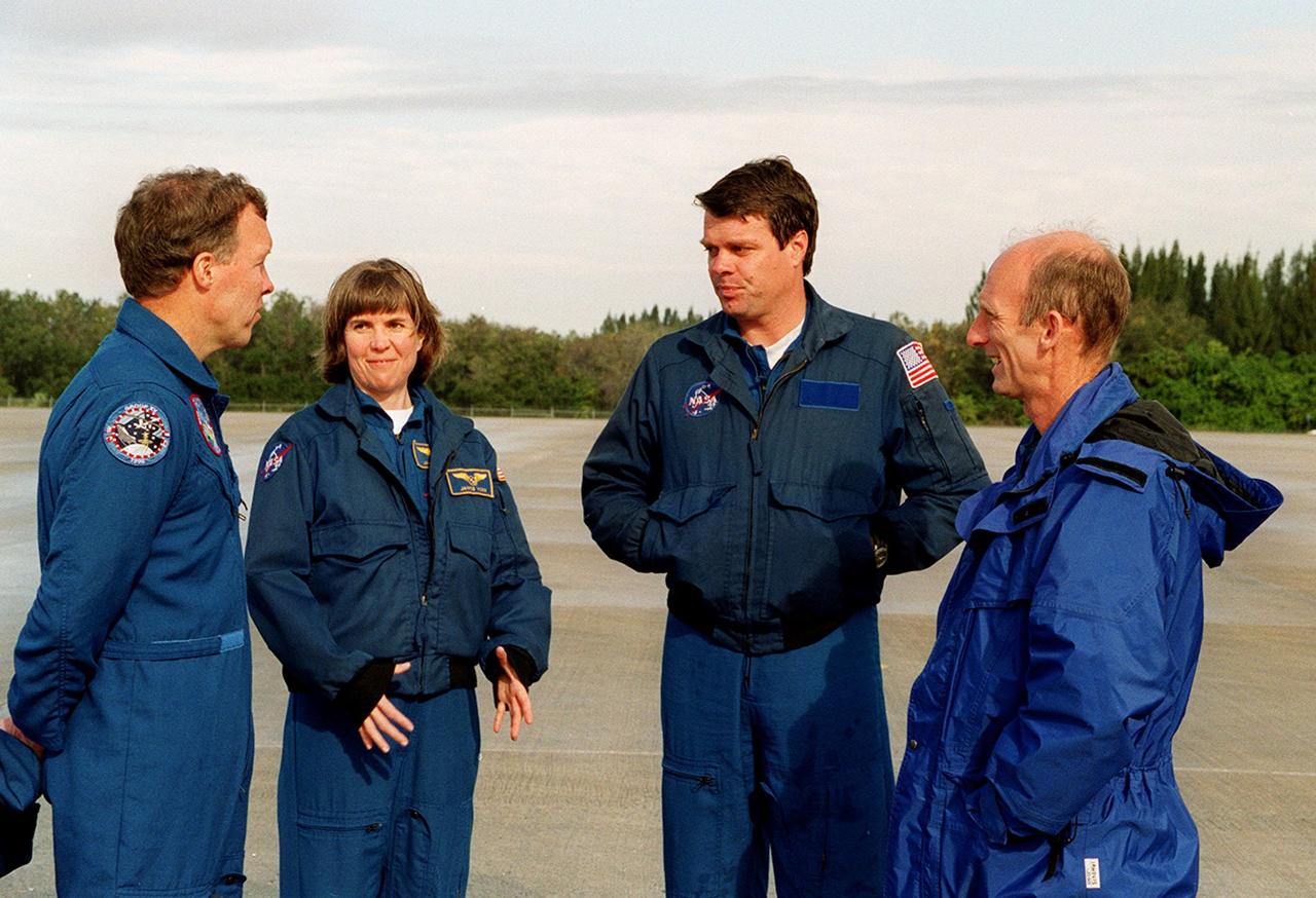
On the runway at the Shuttle Landing Facility, STS-99 crew members Pilot Dominic Gorie, Mission Specialist Janice Voss, Commander Kevin Kregel and Mission Specialist Gerhard Thiele discuss departure plans to Houston. Kregel and Gorie will be piloting T-38 jets with Voss and Thiele as passengers. During the Jan. 31 launch countdown, Endeavour's enhanced master events controller (E-MEC) No. 2 failed a standard preflight test. Launch was postponed and Shuttle managers decided to replace the E-MEC located in the orbiter's aft compartment. Launch controllers will be in a position to begin the STS-99 countdown the morning of Feb. 6 and ready to support a launch midto latenext week pending availability of the Eastern Range. The postponed launch gives the crew an opportunity for more training and time with their families. Known as the Shuttle Radar Topography Mission, it will chart a new course to produce unrivaled 3-D images of the Earth's surface, using two antennae and a 200-foot-long section of space station-derived mast protruding from the payload bay. The result could be close to 1 trillion measurements of the Earth's topography. Besides contributing to the production of better maps, these measurements could lead to improved water drainage modeling, more realistic flight simulators, better locations for cell phone towers, and enhanced navigation safety

On the runway at the Shuttle Landing Facility, STS-99 crew members Mission Specialists Gerhard Thiele and Janice Voss, Commander Kevin Kregel and Pilot Dominic Gorie briefly talk to the media about their imminent departure to Houston. Kregel and Gorie will be piloting T-38 jets with Voss and Thiele as passengers. During the Jan. 31 launch countdown, Endeavour's enhanced master events controller (E-MEC) No. 2 failed a standard preflight test. Launch was postponed and Shuttle managers decided to replace the E-MEC located in the orbiter's aft compartment. Launch controllers will be in a position to begin the STS-99 countdown the morning of Feb. 6 and ready to support a launch midto late next week pending availability of the Eastern Range. The postponed launch gives the crew an opportunity for more training and time with their families. Known as the Shuttle Radar Topography Mission, it will chart a new course to produce unrivaled 3-D images of the Earth's surface, using two antennae and a 200-foot-long section of space station-derived mast protruding from the payload bay. The result could be close to 1 trillion measurements of the Earth's topography. Besides contributing to the production of better maps, these measurements could lead to improved water drainage modeling, more realistic flight simulators, better locations for cell phone towers, and enhanced navigation safety
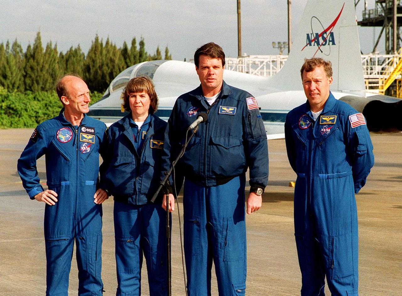
On the runway at the Shuttle Landing Facility, STS-99 crew members Mission Specialists Gerhard Thiele and Janice Voss, Commander Kevin Kregel and Pilot Dominic Gorie briefly talk to the media about their imminent departure to Houston. Kregel and Gorie will be piloting T-38 jets with Voss and Thiele as passengers. During the Jan. 31 launch countdown, Endeavour's enhanced master events controller (E-MEC) No. 2 failed a standard preflight test. Launch was postponed and Shuttle managers decided to replace the E-MEC located in the orbiter's aft compartment. Launch controllers will be in a position to begin the STS-99 countdown the morning of Feb. 6 and ready to support a launch midto late next week pending availability of the Eastern Range. The postponed launch gives the crew an opportunity for more training and time with their families. Known as the Shuttle Radar Topography Mission, it will chart a new course to produce unrivaled 3-D images of the Earth's surface, using two antennae and a 200-foot-long section of space station-derived mast protruding from the payload bay. The result could be close to 1 trillion measurements of the Earth's topography. Besides contributing to the production of better maps, these measurements could lead to improved water drainage modeling, more realistic flight simulators, better locations for cell phone towers, and enhanced navigation safety